Embed Size (px)
Citation preview

This proprietary document and all information contained therein is the property of Esterline CMC Electronics (CMC), its divisions and subsidiaries. It may not be used, copied, reproduced or otherwise dealt
with, nor may its contents be communicated to others in whole or in part, without the express written consent of CMC. It may not be used directly or indirectly for purposes other than those expressly granted in
writing by CMC.
www.cmcelectronics.ca
New GPS TechnologiesFOR HELICOPTER SAFETY

Esterline CMC Electronics – Proprietary DataAugust-1-16
LP & LPV Approaches• Localizer performance with vertical
guidance (LP/LPV) are the highest
precision GPS (SBAS enabled) aviation
instrument approach procedures
currently available. Provides CAT I
equivalent approach. LPV approach
can provide vertical guidance to minima
as low as 200 feet AGL.
• Made possible by SBAS
1
CAT I approach capability provided
By CMC’s CMA-5024 & CMA-6024

Esterline CMC Electronics – Proprietary DataAugust-1-16
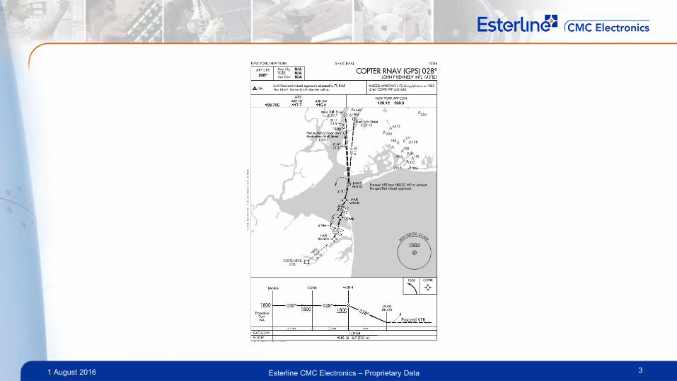
PinS: Point in Space Approach• An approach procedure originally designed for helicopters that includes both an
instrument and a visual segment
• PinS approaches can have LNAV or LPV minima
• Approach will be up until a point in space (MAP), after which, the pilot should have
visual reference to the landing site (Helipad) or initiate missed approach
• Main advantage is the flexibility to position the MAP freely. Especially in
obstacle/congested areas e.g. NYC
2
Supported by CMC’s CMA-5024
& CMA-6024
Esterline CMC Electronics – Proprietary Data1 August 2016 3

Esterline CMC Electronics – Proprietary Data1 August 2016
ADS-B Out
4
Automatic dependent surveillance –
broadcast (ADS–B) is a cooperative
surveillance technology in which an aircraft
determines its position via satellite
navigation and periodically broadcasts it,
enabling it to be tracked.
An SBAS Certified GPS is
recommended by the authorities and
provides best integrity and availability
• Flight ID
• Position + Certainty
• Altitude
• Vertical Tendency
• Distance
• Heading
• GS/IAS
Supported by CMC’s CMA-5024
& CMA-6024

Esterline CMC Electronics – Proprietary DataAugust-1-16
LP & LPV Approaches• GBAS: Ground Based Augmentation System augments the existing GPS utilized in
the airspace by providing corrections to aircraft in the vicinity of an airport in order to
improve the accuracy of, and provide integrity for, these aircrafts' GPS navigational
position.
• The goal of GBAS implementation
is to provide GLS approaches, an
alternative to the Instrument
Landing System (ILS) supporting
the full range of approach and
landing operations CAT I/II/III
• LAAS: Local Area Augmentation
System, US implementation of
GBAS
5
Available on CMC’s CMA-6024

Esterline CMC Electronics – Proprietary DataAugust-1-16
GVS: GPS Velocity Sensor• CMC’s GPS Emulates Doppler Velocity Sensor (DVS) used in Hover Hold
• GVS takes advantage of existing AP interface and controls: Plug&Play. No difference
in operation
• Extremely precise (drift 2cm/24hr) vs. Doppler (1m/mins)
• No new equipment = less weight
6
Available on CMC’s CMA-5024 &
CMA-6024

Esterline CMC Electronics – Proprietary DataAugust-1-16
GVS: GPS Velocity Sensor• Zero drift hover hold: Predictable
� reduce workload increase effectiveness
• Not affected by environment, terrain,
current or rotor downwash
• Other capabilities not affected: ADS-B,
LPV, RNP C
• Flight tested and certified on Bell412EP.
Technical paper on success story
presented at AHS in 2011
7
Made possible by CMC’s CMA-5024
& CMA-6024

This proprietary document and all information contained therein is the property of Esterline CMC Electronics (CMC), its divisions and subsidiaries. It may not be used, copied, reproduced or otherwise dealt
with, nor may its contents be communicated to others in whole or in part, without the express written consent of CMC. It may not be used directly or indirectly for purposes other than those expressly granted in
writing by CMC.
www.cmcelectronics.ca
LPV Approaches FOR OFFSHORE HELICOPTER OPERATIONS

Esterline CMC Electronics – Proprietary Data1 August 2016
LPV for Helicopter Offshore Operations
9
Localizer Performance with
Vertical Guidance
NOTE: Offshore helicopter operations usually refers to water-installed oil/gas fixed base platform personnel and cargo support operations using large transport helicopters
A satellite-derived, synthesized Instrument
Landing System using GPS-SBAS to provide
higher levels of precision and safety during
helicopter approach and landing for offshore
operations.

Esterline CMC Electronics – Proprietary DataAugust-1-16
LPV for Helicopter Offshore Operations• Benefits to helicopter offshore operator
– Provides a safe oil platform helideck approach solution where visibility may be
reduced by weather or darkness (traditional navaids are not installed)
– May permit lower approach minima than today
– Allows for higher degree of flight/mission completion
– Supports an integrated solution
– Reduces flight crew workload
– ILS look-alike support easy aircraft integration and pilot training
• Application where it can be used
– Any helicopter where lateral & vertical deviation information can be displayed to
the flight crew
– Any fixed-base landing pad with known GPS position information where new
Approach Procedures can be written
10

Esterline CMC Electronics – Proprietary DataAugust-1-16
LPV in Use TodayLPV can only be enabled if the positioning source is an SBAS/GPS receiver. An
SBAS receiver also meets/exceeds the ADS-B requirement for a high integrity
position source
LPV is similar to ILS LOC/GS, enabling accurate descent to 200-250 feet above the
helideck. A “Delta-4” SBAS receiver outputs look-alike LOC and GS guidance.
LPV approaches are operationally equivalent to ILS. However, LPV does not require
installation of navigation infrastructure on helidecks - is contained entirely within the
helicopter avionics
There are over 3000 LPV approaches in use today by GA and EMS helicopter
operators in the US and the FAA publishes 300 new LPV approaches/year, see next
slide for WAAS procedures11

Esterline CMC Electronics – Proprietary DataAugust-1-16
WAAS-Capable Approaches(by Procedure Type), March 2016
12
Procedures at NON
Part 139 airports
Procedures at
Part 139 airports
Total Number of
Procedures
LNAV
Procedures4272 1773 6045
LNAV/VNAV
Procedures2110 1392 3502
LPV Procedures 2232 1396 3628
LPV Procedures
w 200 HAT300 642 942
LP 521 83 604

Esterline CMC Electronics – Proprietary Data1 August 2016
LPV Operations Approved in the US
13

Esterline CMC Electronics – Proprietary DataAugust-1-16
Current Offshore Approach Issues• Typically flown using standard raw data – poor precision when visual cues are degraded or absent
• Tend to result in high workload for the flight crew especially in poor visibility
• Standard weather radar is used to identify platform centre of
mass and avoid obstacles – NOT ideal
• Single radar altimeter used for height
• awareness
• Not operator friendly
• No precise lateral deviation/guidance
• Wind not accounted for
• Significant training burden
14

Esterline CMC Electronics – Proprietary DataAugust-1-16
LPV Helicopter Approach Benefits • Provides standard LOC/GS
guidance visual cues
• Integrated with helicopter AFCS for coupled
approach – possible lower landing minima
• LPV is a straight-in approach to any oil platform
• Establishes a safe missed approach procedure
• Crew uses weather radar and radar altimeter for
verification
• “Bolt-On” avionics retrofit to existing helicopters,
no oil platform equipment required
15

Esterline CMC Electronics – Proprietary DataAugust-1-16
Standalone LPV with CMC GLSSU• GLSSU sensor provides
both navigation (Beta-3) andstandalone LPV capability (Delta-4)Beta-3 = best SBAS navigation performance Delta-4 = SBAS LPV LOC and GS guidance is provided
• ARINC 743B compliantJ1 navigation connector (1Hz)J3 approach connector (20Hz) Complete Solution update (10Hz)J2 RF connector (antenna C190)
• LP/LPV installs “on top of” FMS,LPV Database hosted in GLSSU,Control Panel selects the LPVand manages the GLSSU
• Growth to GBAS/LAAS GLSwith future upgrade
16
CMA-5025
GLSSU Control
Panel
+
CMA-5024
GLSSU Landing
Guidance Unit
GPS Landing System Sensor Unit (GLSSU)

Esterline CMC Electronics – Proprietary DataAugust-1-16
LPV Landing Guidance Architecture
17
DMEDMEDMEDME VORVORVORVOR
Flight Mode Flight Mode Flight Mode Flight Mode GLSGLSGLSGLS
Source Source Source Source SelectSelectSelectSelect
Nav SystemNav SystemNav SystemNav System
Radio-Nav Control
Heads
Flight Flight Flight Flight Guidance Guidance Guidance Guidance DisplaysDisplaysDisplaysDisplays
CMACMACMACMA----5024 GLSSU5024 GLSSU5024 GLSSU5024 GLSSU& High Integrity & High Integrity & High Integrity & High Integrity
Switch Switch Switch Switch
GLS GLS GLS GLS CMACMACMACMA----5025 5025 5025 5025
Control Control Control Control PanelPanelPanelPanel
Flight Mode Flight Mode Flight Mode Flight Mode GLSGLSGLSGLS
AnnunciatorAnnunciatorAnnunciatorAnnunciator
Esterline CMC Electronics – Proprietary DataAugust-1-16
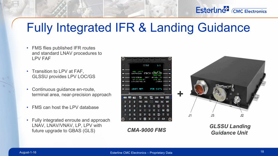
Fully Integrated IFR & Landing Guidance
• FMS flies published IFR routesand standard LNAV procedures to LPV FAF
• Transition to LPV at FAF,GLSSU provides LPV LOC/GS
• Continuous guidance en-route, terminal area, near-precision approach
• FMS can host the LPV database
• Fully integrated enroute and approach LNAV, LNAV/VNAV, LP, LPV with future upgrade to GBAS (GLS)
18
+
GLSSU Landing
Guidance UnitCMA-9000 FMS

Esterline CMC Electronics – Proprietary Data1 August 2016
LPV with FMS, GPS-WAAS & SBAS
19
• Precision Approach to 200 feet (FAA 200 feet « near Cat-1 »)
• GLSSU: a dual purpose GPS Sensor
– Provides RNP Navigation Capability
– Provides Approach Capability, including Precision Approach Navigator, Localizer, Glide Slope and DME outputs
– “BOLT-ON” solution for easy retrofit or new aircraft integration
– Low Altitude IFR for helicopters using SBAS
• Helicopter LPV Operations
– Pilot selects approach source (either ILS or LPV) per approach plate
– If LPV approach is selected, GLSSU switches out ILS Receiver LOC and GS and replaces with GLSSU calculated LOC and GS (ILS look-alike)
– If ILS is selected, ILS “passes through” GLSSU “as-is” (like through relay)

Esterline CMC Electronics – Proprietary Data1 August 2016
LPV Offshore Approach Procedure
20
*
*
*
*
*
*
IAF FAF MAP
Initial
Approach
Segment
Final
Approach
Segment
Missed
Approach
Segment
Oil Rig
HeliDeck
H
.75NM
.25NM Offset
50 Ft
Deck Height
30 °°°°
.5-.6NM
Min MDA 200 ft
300 ft at night
Plan View
Profile View
* Heli
Deck2 NM
4-6º

Esterline CMC Electronics – Proprietary Data1 August 2016
Summary
21
• Typical helicopter offshore operations need a better, safer and far more precise instrument approach procedure to offshore platforms
• WAAS in the US and EGNOS in Europe offers a very unique solution with many other benefits for offshore operators
• LPV holds the promise of significantly enhancing safety of operations through improved positional and approach path accuracy
• LPV operations will only require minimal cost equipment installed on the helicopter and virtually none on the oil platform helideck