Embed Size (px)
Citation preview

ICES Advice North Atlantic Ecoregion Published 20 June 2017 vme.neafc DOI: 10.17895/ices.pub.3060
ICES Advice 2017 1
New information regarding vulnerable habitats in the NEAFC Regulatory Area Advice summary ICES advises that the existing NEAFC closure in the Hatton–Rockall Basin be extended to encompass new records of VME habitat (deep-sea sponge aggregations). Further records of VME indicators were made on the Rockall Bank, but ICES does not consider that any changes are needed to the boundaries of NEAFC bottom-fishing closures in this area. A limited amount of bottom-trawl fishing is occurring within closed areas, or in the waters between NEAFC fishing areas. Request NEAFC requests ICES to continue to provide all available new information on distribution of vulnerable habitats in the NEAFC Convention Area and fisheries activities in and in the vicinity of such habitats, and provide advice relevant to the Regulatory Area and the above mentioned objectives. Elaboration on the advice Hatton–Rockall Basin Three new vulnerable marine ecosystem (VME) habitat records, in the form of soft-bottom deep-sea sponge aggregations, including a mix of Pheronema spp. and Hyalonema spp. (stalked sponges) as well as unknown larger species, were recorded in the Hatton–Rockall Basin at water depths of approximately 1200 m. The sponge aggregations were present along the full length of the survey transects. Since the existing NEAFC bottom-fishing closure does not fully enclose the new records of VME habitat, ICES advises an extension of the closure using the coordinates provided in Table 1 and shown in Figure 1. Table 1 The coordinates for each vertex of the proposed extended Hatton–Rockall Basin bottom-fishing closure. Coordinates are
shown in both decimal degrees (DD) and degrees, minutes, and seconds (DMS).
Point Latitude (DD) Longitude (DD) Latitude (DMS) Longitude (DMS)
1 58.10772 −16.619213 58o 6' 27.792" N 16o 37' 9.167" W
2 58.265568 −16.474374 58o 15' 56.045" N 16o 28' 27.746" W
3 58.112869 −16.17333 58o 6' 46.328" N 16o 10' 23.988" W
4 58.05719 −16.173806 58o 3' 25.884" N 16o 10' 25.702" W
5 58.024825 −16.419742 58o 1' 29.370" N 16o 25' 11.071" W
6 58.043576 −16.615919 58o 2' 36.874" N 16o 36' 57.308" W
Published 20 June 2017 ICES Special Request Advice vme.neafc
2 ICES Advice 2017
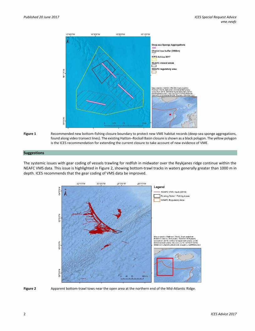
Figure 1 Recommended new bottom-fishing closure boundary to protect new VME habitat records (deep-sea sponge aggregations, found along video transect lines). The existing Hatton–Rockall Basin closure is shown as a black polygon. The yellow polygon is the ICES recommendation for extending the current closure to take account of new evidence of VME.
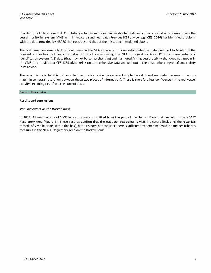
Suggestions The systemic issues with gear coding of vessels trawling for redfish in midwater over the Reykjanes ridge continue within the NEAFC VMS data. This issue is highlighted in Figure 2, showing bottom-trawl tracks in waters generally greater than 1000 m in depth. ICES recommends that the gear coding of VMS data be improved.
Figure 2 Apparent bottom-trawl tows near the open area at the northern end of the Mid-Atlantic Ridge.
ICES Special Request Advice Published 20 June 2017 vme.neafc
ICES Advice 2017 3
In order for ICES to advise NEAFC on fishing activities in or near vulnerable habitats and closed areas, it is necessary to use the vessel monitoring system (VMS) with linked catch and gear data. Previous ICES advice (e.g. ICES, 2016) has identified problems with the data provided by NEAFC that goes beyond that of the miscoding mentioned above. The first issue concerns a lack of confidence in the NEAFC data, as it is uncertain whether data provided to NEAFC by the relevant authorities includes information from all vessels using the NEAFC Regulatory Area. ICES has seen automatic identification system (AIS) data (that may not be comprehensive) and has noted fishing vessel activity that does not appear in the VMS data provided to ICES. ICES advice relies on comprehensive data, and without it, there has to be a degree of uncertainty in its advice. The second issue is that it is not possible to accurately relate the vessel activity to the catch and gear data (because of the mis-match in temporal resolution between these two pieces of information). There is therefore less confidence in the real vessel activity becoming clear from the current data. Basis of the advice Results and conclusions VME indicators on the Rockall Bank In 2017, 41 new records of VME indicators were submitted from the part of the Rockall Bank that lies within the NEAFC Regulatory Area (Figure 3). These records confirm that the Haddock Box contains VME indicators (including the historical records of VME habitats within this box), but ICES does not consider there is sufficient evidence to advise on further fisheries measures in the NEAFC Regulatory Area on the Rockall Bank.

Published 20 June 2017 ICES Special Request Advice vme.neafc
4 ICES Advice 2017
Figure 3 New VME indicator records for the Rockall Bank (and VME habitat records in the Hatton–Rockall Basin) within the NEAFC Regulatory Area. New records outside the NEAFC Regulatory Area are displayed as transparent.
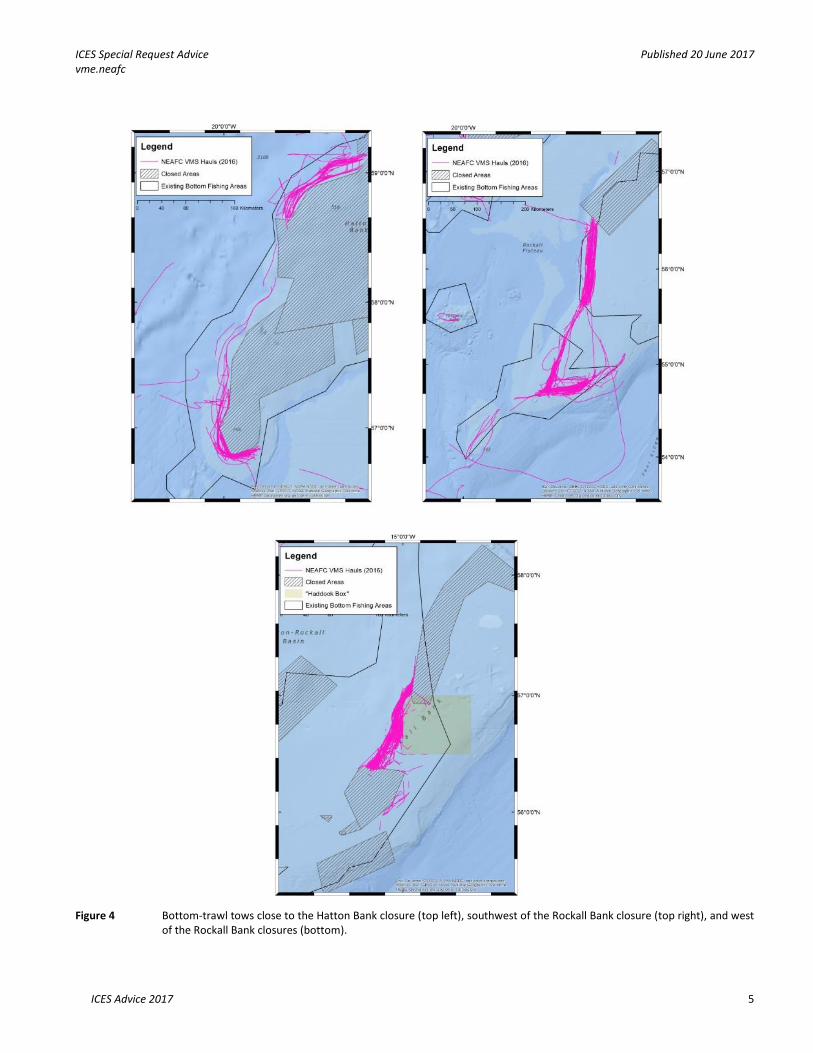
Fishing activities in and near NEAFC closed areas ICES plotted bottom-trawl fishing tracks, based on VMS data received in and near the Hatton Bank and Rockall Bank closures. There were no records of such fishing near other closures. There were relatively minor infringements into the Hatton Bank and Rockall Bank closures. Some trawling still occurs in the northwestern part of the Haddock Box and outside the fishing areas southwest of Rockall (Figure 4).
ICES Special Request Advice Published 20 June 2017 vme.neafc
ICES Advice 2017 5
Figure 4 Bottom-trawl tows close to the Hatton Bank closure (top left), southwest of the Rockall Bank closure (top right), and west
of the Rockall Bank closures (bottom).

Published 20 June 2017 ICES Special Request Advice vme.neafc
6 ICES Advice 2017
Methods Hatton–Rockall Basin Surveys using high resolution video chariot tows were conducted in 2016. The boundary of the ICES recommended closure was produced using the following standard process:
1) All new VME data and associated imagery were reviewed by specialist experts. 2) A buffer zone was applied around each video transect, in line with ICES advice (ICES, 2013). These buffer zones
considered two aspects: a) Positional accuracy of the record: the video chariot system used to identify the VME was towed
approximately 1500 m behind the vessel. b) Warp length of bottom-fishing vessels: ICES has previously advised that at depths greater than 500 m, a
buffer of twice water depth should be used; the records were located at water depths of approximately 1200 m.
3) A boundary was drawn around the area of sensitive seabed habitat with a total buffer of 3900 m (1500 m + (2 × 1200 m)) (Figure 1).
Sources and references ICES. 2013. Report of the ICES\NAFO Joint Working Group on Deep-water Ecology (WGDEC), 11–15 March 2013, Flødevigen, Norway. ICES CM 2013/ACOM:28. 95 pp.
ICES. 2017. Report of the ICES/NAFO Joint Working Group on Deep-water Ecology (WGDEC), 20–24 March 2017, Copenhagen, Denmark. ICES CM 2017/ACOM:25. 119 pp.