Embed Size (px)
Citation preview


New Mexico Bureau of Mines & Mineral Resources
A DIVISION OF NEW MEXICO INSTITUTE OF MINING & TECHNOLOGY
Fluorspar in New Mexico
by William N. McAnulty
SOCORRO 1978


iii
Acknowledgments This report is the product of a study of all previously published works on fluorspar
in New Mexico and evaluation of new data gathered over a period of six years (1970-75) by the author and ten graduate students (working on M.S. theses under his direction) at University of Texas at El Paso. Also, a significant contribution was made by a graduate student at University of Western Ontario. Altogether, the results of eight M.S. theses on fluorspar in New Mexico are incorporated in this report. In addition to revising and supervising the theses, I examined all of the principal deposits in the state.
This study was sponsored by the New Mexico Bureau of Mines and Mineral Resources, and special thanks are due Dr. Frank E. Kottlowski, Director, for his support and encouragement in the initiation and execution of the project. Grants-in-aid were provided by New Mexico Bureau of Mines and Mineral Resources to the following graduate students at University of Texas at El Paso: Edward J. Huskinson for work in the Chise area, Sierra County; Robert C. Rogers, eastern Caballo Mountains, Sierra County; Martin A. Nelson, southern Caballo Mountains, Sierra County; Richard W. Morris, northern Cooke's Peak area, Grant County; Brad P. Biggerstaff, Steeple Rock-Twin Peaks area, Grant County; Randal I. Arnold, Little Whitewater-Holt Canyon area, Catron County; Harold M. Messenger, Zuni Mountains, Valencia County; and Thomas J. Glover, western Organ Mountains, Dona Ana County.
Walter V. Kramer and Roger D. Ellis, also graduate students at University of Texas at El Paso, were given financial support by the Rangaire Corporation, Cleburne, Texas, for their work in the Bishop Cap area, Doña Ana County, and the Winkler anticline in the Animas Mountains, Hidalgo County, respectively.
Thesis studies by students from other universities that contributed significantly to the knowledge of fluorspar in New Mexico include Harold Backer, New Mexico Institute of Mining and Technology, for the Gila area, Grant County; and Albert Lamarre, University of Western Ontario, for the Salado area, Sierra County. Lamarre's work was sponsored by Midwest Oil Corporation.
Several companies, including Allied Chemical Corporation, Louisiana Land and Exploration Company, Rangaire Corporation, and American Mining and Milling Company, supplied valuable information. Ira Young also furnished data on several fluorspar deposits (Chise, White Eagle, and Little Whitewater-Holt Canyon deposits). Other individuals who contributed valuable information are Milton Head (Zuni district), John Hanson (northern Caballo Mountains), and Howard E. Rothrock (Burro Mountains). Previously published works by Howard E. Rothrock (1970; Rothrock, Johnson, and Hahn, 1946), Elliot Gillerman (1952), and Frank E. Williams (1966) were particularly helpful.
The manuscript was reviewed by Ralph E. Van Alstine, Resource Geologist for Fluorspar with the U.S. Geological Survey, and I appreciate his helpful comments and corrections. Much of the original drafting was done by Dennis L. Kuhfal, graduate student in the Department of Geological Sciences at University of Texas at El Paso.
El Paso, Texas William N. McAnulty June 1977 Professor of Geology
Department of Geological Sciences University of Texas at El Paso


7
Abstract Current knowledge and theories about the geology of fluorspar are summarized,
and the many industrial uses of this important mineral commodity are discussed in this report. New geological data on several fluorspar districts and specific deposits in New Mexico, the results of recent detailed studies of several areas by graduate students at University of Texas at El Paso and University of Western Ontario, and by the writer, are also presented. Exploration, new fluorspar discoveries, and mining performed in New Mexico since 1966 are included. The tonnage and grade of identified reserves in the United States are inadequate to supply the domestic demand, and more than 80 percent of the fluorspar consumed in the United States is imported. Southwestern New Mexico is a fluorine-rich province in which more than 200 fluorspar deposits have been discovered in districts scattered over 13 counties. Systematic exploration in several districts could discover large low-grade resources, particularly fluorspar-bearing jasperoid deposits. In the not too distant future, deposits in New Mexico may become significant sources of fluorspar.
General information on fluorspar Introduction
Fluorspar is the commercial name for an aggregate of rock and mineral matter containing a sufficient amount of the mineral fluorite (CaF2 ) to qualify the aggregate as a marketable commodity, or as a primary source (ore) of a profitable, salable product after beneficiation. Fluorite is the principal source of fluorine, an element which is used in many ways by modern industry, and there are no adequate substitutes for it in any of its major uses. The principal uses of fluorspar are as a source of fluorine for making hydrofluoric acid (HF), as a flux in metallurgy, and as a raw material in the manufacture of glass and enamels.
Fluorspar is a relatively scarce mineral commodity, and the United States imports more than 80 percent of its requirements. Although occurrences of fluorspar are known at more than 200 different places scattered over 13 counties in New Mexico, and small-scale mining has been done on 91 deposits in 11 counties in the state, the aggregate total mine production of fluorspar in New Mexico since the early 1880's is approximately 700,000 tons of all grades. However, several companies, groups, and individuals are actively exploring and evaluating fluorspar districts in the state at the present time, and chances are good that New Mexico will become an important fluorspar producer in the near future.
Geology of fluorspar Mineralogy
Fluorite (CaF2 ; calcium, 51.1 percent, and fluorine, 48.9 percent) is the most abundant fluoride mineral. It crystallizes in the isometric system, usually in cubic form hut also in octahedral and dodecahedral forms. The mineral possesses perfect octahedral cleavage, has a hardness of 4 on the Mohs scale, and its specific gravity ranges from 3.01 to 3.6 in various forms; pure crystal-line fluorite has a specific gravity of 3.18. Colors of the mineral vary greatly, and fluorite may be colorless, white, yellow, green, violet, purple, blue, pink, red, brown, light to dark gray, or black. Crystalline varieties have a vitreous luster and range from transparent to subtranslucent; a diagnostic optical property of fluorite
is its low index of refraction, n=1.4339. It is isotropic, has low dispersion, and some varieties will transmit ultraviolet light.
Fluorite may be finely to coarsely crystalline, massive, compact, earthy, and (rarely) columnar. It is a ubiquitous and persistent mineral which forms and exists under a wide range of temperature and pressure con-ditions. Commonly, it is intercrystallized with calcite, quartz, and pyrite, and it is frequently associated with galena, sphalerite, and barite, and less frequently with celestite, strontianite, and witherite.
Other minerals found in fluorspar deposits include rhodochrosite, biotite, potassium feldspars, and molyb-denite. Other elements found in fluorspar deposits, sometimes in co- or by-product quantities, include: sulfur, gold, silver, beryllium, scandium, manganese, tin, tungsten, rare earths, and uranium.
Geochemistry of fluorine As fluorite is an important industrial mineral com-
modity because of its fluorine content, some knowledge of the geochemistry of fluorine is essential for under-standing the origins and modes of occurrence of fluorite.
Fluorine is a highly reactive, gaseous element, having the highest electron affinity of all of the elements. The fluorine atom contains 9 protons and 10 neutrons. Its only isotope usually occurs as a singly charged anion, F-. The atom has a radius of 1.33A, and under favorable valency conditions it can easily substitute diadochically for the hydroxyl ion (OH)- and the oxygen ion O-2, all of which have radii of about the same size.
Fluorine is widely dispersed throughout the litho-sphere, hydrosphere, and biosphere. It is a characteristic constituent of alkalic and silicic alkali magmas and plays an important role in the later ("fugitive") stages of their differentiation. Large amounts of fluorine issue to the surface and into the atmosphere and probably onto the ocean floor and into sea waters through volcanic activity. Both surface and ground waters contain fluoride in amounts controlled by the nature of the bedrocks and the source of the waters. Some highly saline lakes have a high fluoride content; recorded contents range from a few ppm to more than 1,600 ppm. According to

8
Fleischer and Robinson (1963), the average fluoride content of river waters is 0.2 ppm. Ground waters containing more than 1.5 ppm are common over large areas. Ten analyses of waters from hot springs in the United States and New Zealand reported by White (1957) contain 1.5 to 21.5 ppm fluorine. According to White (1955), thermal springs at Poncha Springs and Browns Canyon, Colorado, and Ojo Caliente, New Mexico, contain fluorine in amounts of 12, 15, and 16 ppm, respectively. Acid spring waters in active volcanic areas in New Zealand contain up to 6,000 ppm fluorine (Mahon, 1964). Sea waters contain less fluorine than hypabyssal rocks because of the removal of fluorine by the formation of fluorapatite on the continental shelves.
Determination of the amounts of fluorine in crustal rocks has proved to be difficult, but values as reported by Fleischer and Robinson (1963, p. 67) for various rock types are as follows (in parts per million): basalt, 360; andesite, 210; rhyolite, 480; phonolite, 930; gabbro, 420; granite and granodiorite, 870; alkalic rock, 1000; limestone, 220; dolomite, 260; sandstone and graywacke, 180; shale, 800; oceanic sediment, 730; and soil, 285.
Although the ultimate source of fluorine is unknown, the fluorine geochemical cycle, as depicted and de-scribed by Peters (1958, p. 666-684) and Worl (1973, p. 224-229), is such that any region initially rich in fluorine will remain so through many geologic cycles. Lamarre (1974) suggests that fluorine may be derived by melting fluorine-rich phlogopite in the deepest parts of subduc-tion zones and may be transported upward as alkali-fluoride compounds, in alkalic magmas.
As stated by Peters (1958, p. 667), the maximum concentration of fluorine occurs during later stages of magmatic and hydrothermal activity and the bio-chemical-phosphatic stage of sedimentation. Most fluorspar deposits appear to be products of the magmatic-hydrothermal environment.
Fluorspar deposits Geologic-mineralogic relationships observable in
most regions where fluorspar deposits occur strongly suggest that the fluorine involved was introduced as a constituent of fluids derived from silica-, soda-, and potash-rich magmas during the late hydrothermal stage of differentiation. Many deposits are associated directly or indirectly with alkali-rich rhyolites and granites; some are associated with syenites, nepheline syenites, and phonolites.
It appears that the fluorite in most commercial deposits formed from fluorine-bearing fluids moving upward and outward from magma chambers along faults and fissures and through permeable rocks where temperature, pressure, and chemical conditions were favorable. Hydrofluoric acid that formed by hydrolysis along the way could react with limestone or calcite encountered as the fluids moved through the rocks and could produce fluorite as in the following reaction: 2HF + CaCO3 = CaF2 + H2O + CO2. The presence of limestone or calcite is not essential to the formation of fluorite; calcium may be available in the hydrothermal fluids due to alteration and breakdown of calcium-bearing silicate minerals. Although fluorite may form and exist in a wide range of temperature and pressure
conditions, many of the larger commercial deposits of fluorspar apparently formed in low-temperature and low-pressure (near-surface) environments from rela-tively cool hydrothermal fluids composed largely of meteoric water.
The best host rocks are permeable, nearly pure limestones that underlie relatively impervious rocks, although fluorspar deposits occur in all kinds of host rocks. Ground preparation is very important for the formation of fluorspar deposits; faults and fractures provide passageways for the fluorine-bearing fluids. Brecciated zones, especially those capped by imperme-able rocks, provide sites favorable for void-filling and replacement deposits. Intrusive igneous processes in-volving alkali magmas contribute to ground preparation and supply fluorine. Tectonic processes which produce crustal deformation (faults and folds) also contribute to ground preparation. For example, Basin-and-Range faulting and associated alkali magmatic activity resulted in widespread occurrences of fluorspar in the western United States.
Commercial fluorspar deposits occur in many different geologic environments and in a variety of forms, the most important being:
1) Fissure veins, both void filling and replacement; may be in any kind of rock along faults and fractures, but more commonly in limestone, rhyolite, granite, or andesite
2) Concordant replacement bodies (stratiform) or mantos in brecciated zones along bedding-plane faults in carbonate rocks
3) Stratiform replacement deposits in permeable carbonate rocks capped by relatively impervious rocks
4) Stratiform replacement/void-filling deposits in jasperoidal bodies replacing carbonate strata or layered volcanic rocks
5) Discordant replacement/void-filling deposits in jasperoidal bodies replacing carbonate strata or layered volcanic rocks
6) Replacement/void-filling deposits in carbonate rocks, usually limestones, in brecciated contact zones adjacent to intrusive silicic, alkali-rich igneous rock, usually rhyolites or granites
7) Replacement/void-filling deposits in collapse breccia in sinkholes and caverns
8) Void-filling deposits in solution channels and other solution cavities
9) Replacement/void filling in breccia pipes 10) Replacement/void-filling stockworks in tecton-
ically-produced shear and shattered zones in limestones, dolomites, calcareous shales, and igneous rocks
11) Replacement/void-filling xenoliths and/or roof pendants in silicic, alkalic intrusions
12) Pegmatites, carbonatites, and alkalic ring-dike complexes. Of the types of deposits listed above, the most
common and most important as sources of fluorspar are: fissure veins, stratiform replacements (mantos) in limestones, and replacements in limestones in contact zones adjacent to silicic-alkalic intrusive igneous rocks (Nos. 1, 2, 3, and 6 above). Several types of deposits commonly occur in the same district. Jasperoid-type deposits (Nos. 4 and 5) may become important in the future—if and when siliceous rock containing 15 to 25 percent CaF2 can be mined and beneficiated at a profit.
FISSURE VEINS—Many of the larger fluorspar mines in

the world are developed on fissure veins located in fault and shear zones. Fluorspar fissure veins are similar in all respects to veins containing concentrations of metallic ore minerals. In fact, fluorite is a gangue mineral in many metallic ore deposits and is sometimes produced as a by-product from such deposits.
Fluorspar deposits in fissure veins may be the result of 1) simple void filling (chemical precipitation), 2) replacement of wallrock and fault breccia, and 3) both void filling and replacement. Commonly, both void filling and replacement were involved. The vein material may be sharply separated from the wall rock on both sides, or only on one side and gradational into the wallrock on the opposite side, or gradational on both sides. Vein deposits characteristically pinch and swell, both along the strike and downdip. Commercial grade vein material is often concentrated in the form of "ore shoots," which are generally structurally controlled.
Fluorite-bearing veins range from a fraction of an inch to several tens of feet in width. Minable fluorspar veins range from about 2 to 40+ ft; the average width is about 15 ft. In general, veins tend to decrease in width with depth. Ore shoots are known to extend to depths of nearly 1,000 ft below the surface, but downdip exten-sions depend on several factors and particularly on the amount of erosion in any given area since the deposits were formed. Strike lengths also vary greatly-from a few tens of feet to several miles, with the average being about 3,000 ft for strong veins.
Fissure veins occur in all kinds of rocks but particu-larly in granitic and andesitic igneous rocks and lime-stones. Most of the fluorspar produced in New Mexico has been mined from veins in Precambrian granites in Grant and Valencia Counties. However, many of the world's great fissure vein deposits are in limestone. As a general rule, commercial fissure vein deposits have a higher CaF2 content than other types of deposits; some void-filling deposits in veins contain very high grade fluorspar.
CONCORDANT REPLACEMENT DEPOSITS (MANTOS)— Concordant (stratiform or strata-bound) replacement deposits in carbonate rocks (usually limestones, dolo-mitic limestones or calcareous shales) are found in brecciated zones related to bedding-plane faulting and in permeable beds or layers overlain by less permeable rocks. They occur at many places throughout the world and are major sources of fluorspar in several districts. Some of the largest fluorspar mines in the world are developed on deposits of this type, including the Illinois-Kentucky district in the United States, and in Mexico, Spain, Italy, Tunisia, and South Africa (Grogan and others, 1974). These bedding replacements, or mantos, are generally concordant with the bedding or layering of the host rock sequence, but they are not necessarily horizontal. Their attitude is the result of the structural position of favorable host zones at the time of fluoritiza-tion and any tectonic deformation of the host sequence after the deposits were formed. The genetic relationship between deposits of this type and cross-cutting passage-ways (faults and fractures), veins, and intrusive igneous bodies is clearly shown in numerous mines and prospects. Ascending mineralizing fluids moved outward into and reacted with favorable beds or layers as they were encountered. These deposits are often extensions
9
of veins and irregular-shaped deposits in contact zones adjacent to intrusive igneous bodies. Their lateral extent may be controlled by several factors, including the temperature, pressure, and concentration of the min-eralizing fluids and the permeability and amenability of the host rock to replacement.
Deposits of this type vary greatly in thickness, length, and grade. Minable thicknesses range from less than 3 to more than 30 ft; lengths range from a few tens of feet to more than 3,000 ft; the CaF2 content ranges from less than 10 to more than 90 percent. The grade and thickness may be variable within a single deposit. Better deposits contain between 60 and 85 percent CaF2. Banded and coontail ores occur in many deposits of this type.
CONTACT ZONE DEPOSITS-Some of the major sources of high-grade fluorspar are replacement/void-filling deposits in brecciated and/or otherwise highly permeable carbonate rocks. These deposits, usually limestones, are adjacent to intrusive silicic-alkalic igneous rocks, particularly rhyolites or granites. Some of the world's largest and highest grade deposits are of this type, most of which are in Mexico (Cuatro PalmasAguachile, Las Cuevas, and Rio Verde districts). Potentially large, high-grade deposits of this type are also known in the Christmas Mountains, Eagle Mountains, and Sierra Blanca Peaks districts in west Texas.
These deposits generally exhibit characteristics of a low-temperature and low-pressure (near-surface) envi-ronment and should be classed as low-temperature hydrothermal rather than contact metamorphic or contact metasomatic. In view of the fact that the intrusive rocks associated with these deposits are generally altered and fluoritized to some degree and commonly are hosts for veins and veinlets of fluorspar, it is obvious that the fluoritization occurred after their emplacement and at least partial solidification. Apparently, the mineralizing solutions were relatively cool and their bulk component may have been meteoric water. However, the close association of deposits of this type with silicic, alkali-rich rhyolites and granites must be more than mere coincidence, and it is believed that the fluorine was brought upward in hydrothermal fluids emanating from the same magma chambers which gave rise to the rhyolites and granites.
The mineralization in the Cuatro Palmas deposit in the Aguachile district in northern Coahuila is typical of the Mexican deposits, and a description of the Cuatro Palmas ore follows (McAnulty and others, 1963, p. 741):
The Cuatro Palmas fluorspar occurs in shades of purple, white, pink, yellow, red, and brown. The nonpurple colors occur as streaks, wavy bands, and splotches in the purplish background, which give the ore a marbleized appearance.
The fluorite formed by replacement of limestone and by direct precipitation in voids. Its texture is dom-inantly microcrystalline; grains range from about 0.01 to 5 mm in diameter. Tiny crystals line small vugs in spongy zones scattered throughout the ore body. In places, the ore is sugary; elsewhere, it has a fibrous structure. Fibrous development is associated with con-cretionary botryoidal, mammillary, reniform, and col-loform masses, which were probably precipitated in voids. Rodlike structures (one sixteenth to 1 inch in diameter) of thin concentric layers, abundant in certain

10
zones, probably represent small stalactites and stalag-mites precipitated in voids; some have solid centers whereas others are hollow and tubelike. Many of the tiny acicular fibers are also hollow.
Most of the ore exhibits a brecciated structure. Angular fragments ranging from a fraction of an inch to 3 inches in diameter are embedded in a mylonitized matrix, all of which is now fluorite. There is evidence of at least two stages of brecciation: ( I) brecciated lime-stone was replaced by fluorite; and (2) the first-generation fluorite was brecciated and rehealed with a second generation of fluorite. The present ore body is the result of at least three generations of fluoritization.
Coon-tail banding is common in the ore. Alternating dark- and light-colored bands one-quarter inch or less in width probably resulted from rhythmic replacement of the limestone. Thin sections show that the dark bands are fluorite and the light-colored bands are either fluorite or calcite, or both in some instances.
Irregular-shaped patches of coarsely crystalline white and brown calcite are fairly numerous in places. Calcite also occurs in seams, veinlets, wavy bands, and streaks in the ore. Stringers and fairly large irregular-shaped masses of rhyolite, commonly highly altered, and some partially replaced limestone are enclosed in the ore body. However, these impurities constitute less than 5 percent of the total volume. The ore averages about 70 percent CaF2 , 18 percent CaCO3 , 5 percent SiO2 , and 7 percent R203 and other impurities.
The Aguachile deposit, located about one mile southeast of the Cuatro Palmas ore body, is another example of a contact zone deposit. It formed in brecciated limestones adjacent to a ring dike of rhyolite, which encircles a sunken prism of Cretaceous limestone formations. The average composition of Aguachile ore is approximately as follows: CaF2 , 81.6 percent; CaCO3 , 12.0 percent; SiO2, 5 percent; BeO, 0.3 percent; and R2O3 and other impurities, 1.1 percent. Texturally and structurally the Aguachile and Cuatro Palmas ores are similar.
An important difference between the mineral compo-sition of the Cuatro Palmas and Aguachile ore bodies is the high beryllium content of the Aguachile ore. The beryllium, contained in bertrandite (Be4(OH)2Si2O7), is extremely variable in its distribution through the ore body, ranging from a few parts per million to more than six percent.
Contact zone deposits in the Sierra Blanca Peaks district, Hudspeth County, Texas, also contain bertran-dite. The beryllium content of several samples analyzed ranged from 1,000 to 10,000 ppm.
JASPEROID DEPOSITS—Both concordant and discordant bodies of silicified (jasperized) rock are widespread in a variety of host rocks in New Mexico and other regions that have been subjected to tectonic and magmatic hydrothermal activities. All rock types are to some degree susceptible to replacement by silica, and lime-stone and dolomite are particularly vulnerable to silici-fication. Jasperoid has been defined as an "epigenetic siliceous replacement of a previously lithified host rock" (Spurr, 1898). Jasperoid is a rock formed by silicification and consisting essentially of very fine grained quartz, chalcedony, or opal. Silica-rich solutions moving along joints and faults and extending outward from them into permeable layers or beds effect replacement
of susceptible rocks and produce jasperoid; contacts with the host rock may be sharp or gradational.
Jasperoid masses are hard and brittle and commonly exhibit a jigsaw-puzzlelike fit of angular pieces of jasperoid of variable sizes. The space between the breccia clasts is usually filled with a later generation of aphanitic but coarser grained silica than that composing the clasts. The brecciation resulted from tectonic move-ments following initial silicification and/or chemical brecciation associated with the hydrothermal replace-ment processes. Original bedding and other primary structures of the host rock may be preserved in places. Unreplaced blocks of host rock, completely surrounded by jasperoid, may be scattered through some bodies. Colors may range through shades of gray to black; dark red is common, as are colored streaks, bands, and splotches.
Analyses of samples of jasperoid indicate that jasperi-zation of limestone results in a loss of MgO, CaO, CO2, and MnO, and a gain of SiO2 (Lamarre, 1974). Trace amounts of several minerals may be present in jas-peroids, including: hematite, limonite, pyrite, siderite, calcite, allophane, and sericite; some contain small amounts of galena and sphalerite and other ore minerals. Many jasperoid bodies contain fluorite and are potential commercial sources of fluorspar.
Jasperoid bodies usually contain appreciable amounts of "secondary," massive, or anhedral quartz precipitated in open spaces during later stages of the hydrothermal cycle. This quartz lines, partially fills, or fills vugs and other openings formed by shrinkage during replacement and tectonically-produced joints, faults, and openings in brecciated rocks formed after the initial silicification. Also, it is in such openings that most of the fluorite occurs. Generally, fluorite is most abundant in fault breccia zones where it cements the angular breccia fragments. However, there may be scattered pods of high-grade fluorspar containing up to several tens of tons. In some manto or concordant bedding-replacement deposits coon-tail banding is well developed. Veins of relatively high-grade fluorspar are associated with discordant jasperoid bodies at several places. The veins may occupy positions on the hanging wall or footwall or within the jasperoid body. Thin sections show minor replacement of quartz and jas-peroid by fluorite, but by far most of the fluorite is medium- to coarse-crystalline, void-filling material.
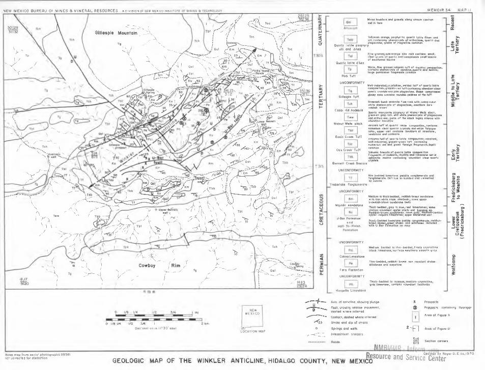
The paragenetic sequence in a fluorite-rich jasperoid deposit located on the Winkler anticline, Animas Mountains, Hidalgo County, New Mexico, is as follows:
1) Silica-rich solutions from a magmatic source at depth entered a folded and faulted sequence of lime-stones and shales, moved upward along faults and spread laterally into permeable beds, particularly along bedding-plane faults produced by earlier folding. The more susceptible limestone beds were almost completely replaced with silica, producing jasperoid in beds overlain by more impermeable rock. Trace amounts of fine-grained, replacement fluorite were formed during this period.
2) The jasperoid was brecciated by tectonic move-ments and possibly by shrinkage of silica gel. Open spaces were provided.
3) A second pulse of hydrothermal activity, richer in

fluorine and poorer in silica than the first pulse, deposited fluorite in available open spaces, forming a fine- to medium-grained cement around breccia frag-ments and coarser aggregates in larger openings. Some quartz was precipitated in open spaces along with fluorite and minor amounts of pyrite.
4) A third and final hydrothermal pulsation resulted in encrustation of subhedral to euhedral quartz crystals on pre-existing minerals, and formation of euhedral crystals of quartz up to 1/8 inch in diameter in larger openings. Little or no fluorite was formed during this final pulse.
The fluorite in jasperoid deposits is not uniformly distributed through the rock; in fact, its distribution is very erratic. Irregular-shaped pods, the location of which is not predictable, may contain a few hundred tons of 50± percent CaF2 , but more often rich concentrations are in pods containing less than one ton. Large areas surrounding the pods commonly contain little or no visible fluorite. The tonnage in the higher grade concentrations is not likely to be enough to support a profitable mining operation. All of the jasperoid body would have to be mined and beneficiated. Ascertaining the average grade of jasperoid deposits is extremely difficult and cannot be done satisfactorily by analyzing chip or channel samples cut from a few outcrops or by analyzing drill cuttings obtained by percussion drilling. Blending sizable bulk samples taken from several places in a deposit and averaging several analyses of a thoroughly mixed composite of the bulk samples probably are the best ways to determine a reliable grade percentage. Jasperoid deposits in Hidalgo and Sierra Counties, New Mexico, which have been carefully sampled and analyzed contain an average of 33.42 and 19.35 percent CaF 2 , respectively.
The size, shape, and attitude of individual jasperoid bodies vary greatly; the bulk tonnage ranges from less than one ton to several million tons. Concordant (manto) bedding replacement deposits range from a few inches to more than 50 ft in thickness; usually the thickness is not uniform. The lateral dimensions of mantos range from a few feet to several hundred feet. Discordant bodies developed along joints and faults range from less than one inch to more than 100 ft in width, and strike lengths vary from a few feet to several miles; dip lengths are unpredictable but are not likely to be more than a few hundred feet. The thickness of the host rock formation often controls the dip dimension.
OTHER TYPES OF DEPOSITS-Several other types of deposits have yielded appreciable fluorspar at one place or another in the world and constitute sources for future production. These include: replacement and void-filling deposits in collapse breccias in sinkholes and caverns; void-filling deposits in solution-enlarged openings; breccia pipes; stockwork and shear-zone deposits; replaced xenoliths, pegmatitic carbonatites, and alkali igneous complexes. Actually, breccia pipes, stockwork and shear-zone deposits, and some void-filling deposits in solution-enlarged openings are not distinct types; all are associated with and part of fissure veins. Breccia pipes also occur in some contact zones.
Replacement and void-filling deposits in collapse breccias and in solution-enlarged openings have been sources of considerable high-grade flourspar, especially
11
in some districts where thick sequences of carbonate rocks have been subjected to strong solutioning, such as the San Vicente district, in Coahuila, Mexico.
Breccia pipes localized along intersecting faults and fractures form "ore shoots" in some fissure veins. Many such pipes contain appreciable amounts of high-grade ore. Replaced brecciated pipe-like structures also occur in some contact zones—for example, Iron Mountain, Sierra County, New Mexico. Breccia pipe deposits range in size from a few feet to several tens of feet in diameter. Some are oval and others are irregular-shaped bodies. Pipes in the Thomas Range (Spor Mountain) in Utah range from 20 to 350 ft long and have been mined to a depth of about 200 ft below the surface, yielding fluorspar ranging from 65 to 95 percent CaF2 . Pipe-like breccia bodies in the Gallinas Mountains, New Mexico, occur as irregular-shaped bodies along fissure veins cutting quartzitic sandstone near an alkali intrusive body. The Gallinas pipes range from 30 to 6,000 ft in length (Perhac, 1970).
Peters (1958, p. 671-672) described several brecciated fluorspar pipes in Utah, Nevada, Colorado, and New Mexico, including deposits at Wagon Wheel Gap, Colorado; Meyers Cove, Idaho; Gallinas Mountains, New Mexico; and Jamestown, Colorado. Brecciation is characteristic of most fluorspar deposits. Premineralization brecciation makes the host rock more vulnerable to mineralizing fluids and provides space for void-filling fluorspar. In many places, brecciation also occurred during fluoritization. Peters (1958, p. 673) suggested "that brecciation in fluorspar deposits commonly reflects alternating conditions of deposition and corrosion."
According to Bateman (1956, p. 124) "a stockwork is an interlacing network of small ore-bearing veinlets traversing a mass of rock. The individual veinlets rarely exceed an inch or so in width or a few feet in length, and they are spaced a few inches to a few feet apart. The interveinlet zone is, or may in part be, impregnated by ore minerals. The entire rock mass is mined." McKinstry (1948, p. 653) defines shear zone as follows: "A layer or slab-like portion of a rock mass traversed by closely spaced zones are special cases of fissure veins, and many fluorspar-bearing veins in western United States are of the stockwork type." Characteristically, the CaF2 content of stockworks is low. Examples of stockwork fluorspar deposits are found in the Little Rocky Mountains, Montana; Climax, Colorado; Questa, New Mexico; and the White Eagle mine in New Mexico. Stock-work and shear-zone deposits are known in granites in the Union of South Africa. Some stockworks are wide and long and contain large tonnages of low-grade fluorspar.
A few commercial fluorspar deposits appear to have been formed by replacement of massive inclusions (xenoliths and/or roof pendants), particularly carbonate rocks, in granitic intrusions, and probably many de-posits of this type have not been identified as such. The Buffalo and related deposits in South Africa are out-standing examples of replacements of massive inclu-sions in granitic rocks (Grogan and others, 1974). The Doña Nino deposits in the Aguachile district, Coahuila, Mexico, may in part be replacement of roof pendants of limestone in a rhyolite intrusion. The Crystal Mountain

12
deposits in Montana, believed by some workers to be of pegmatitic origin, may be replacements of calcareous rock inclusions in granite.
Pegmatites, pegmatitic carbonatites, and alkali ig-neous complexes contain interesting amounts of fluorspar in several districts in the world, but, to date. deposits in these environments have not been important sources of supply. However, some are potential sources for large, low-grade resources of fluorspar and a variety of by- or co-products.
Fluorite and other fluorine-bearing minerals are common constituents of granitic pegmatites, and some high-temperature quartz veins associated with pegmatites also contain fluorite. According to Jahns (1946, p. 62) most of the pegmatites in the Petaca district, Mora County, New Mexico, contain fluorite in pods, rounded masses, and veinlets. Fluorite is present in numerous Precambrian zoned pegmatites in Colorado—particularly marginal to the core and in the altered wall zone.
Fluorine seems to be a characteristic constituent of carbonatite intrusions. Calcite and dolomite are the chief constituents in carbonatites, but several other carbonates may be present in lesser amounts, including ankerite, siderite, and manganiferous carbonates. Rare earth carbonates such as bastnaesite are widely distributed through some carbonatite masses, for example, al Mountain Pass, California. Many other minerals are found in carbonatites, including the following: apatite. barite, fluorite, pyrochlore, and perovskite. Carbonatites are invariably associated with stocks, ring-dike com-plexes, or plugs of basic alkaline rocks (Turner and Verhoogen, 1960, p. 398).
The Snowbird fluorspar deposit in the Bitterroot Mountains of Montana is in a small intrusive body which has been described as a carbonatite pegmatite (Clabaugh and Sewell, 1964, p. 268). The Mountain Pass carbonatite in California contains sizable pods of fluorite, as well as barite and bastnaesite. The Okorusu deposit in southwest Africa is a good example of fluorspar associated with carbonatite and alkali rock complexes. According to Grogan and others (1974, p. 8):
This deposit consists of a number of bodies of fluorspar in a 900-foot-high curving ridge made up of limestones, quartzites, and related rocks which have been intruded and metamorphosed by an alkalic ig-neous rock complex, including a nepheline syenite stock. The fluorspar appears to have replaced bedded and brecciated limestone, marble, and quartzite, form-ing large lenticular masses of irregular shape. Apatite and quartz are abundant accessory minerals.
The types of deposits and depositional environments described above are the principal sources of commercial fluorspar ore at the present time. All are epigenetic. However, syngenetic fluorite and other fluorine-bearing minerals are known to occur in lacustrine, volcaniclastic, evaporite, and marine carbonate sedimentary rocks. Interesting occurrences of fluorspar are also known in greisens, tactites, and in silicic volcanic rocks in association with topaz.
Mining and Beneficiation The mining of fluorspar does not differ in any
important aspects from the mining of metalliferous
deposits, except for scale. Most fluorspar mining opera-tions do not lend themselves to large-scale mining. Both opencast and underground methods are employed, depending on the type of the deposit. Shrinkage and sublevel stoping are commonly used in vein deposits, whereas some form of room-and-pillar or cut-and-fill method is generally used in bedded deposits. Some larger operations are highly mechanized, but the degree of mechanization varies greatly from mine to mine, depending on the location, size, shape, and grade of the deposit, and the financial condition of the operator. In view of the fact that most commercial deposits occur either in vertical or steeply dipping fissure veins or in horizontal to subhorizontal "bedded" replacement deposits, most of the fluorspar produced in the world comes from underground mines. A few deposits at or near the surface are worked by opencast methods using various kinds and sizes of earth-moving equipment. The Cuatro Palmas deposit in Mexico, an inverted cone-shaped replacement ore body that is now nearly depleted, was mined by open pit to a depth of about 300 feet. A steep haulage road spiralled tightly around the outside of the oval-shaped deposit. The Cuevas mine near the City of San Luis Potosi in Mexico is being mined on a sizable scale by the room-and-pillar method. The bedded replacement deposits in the Illinois-Kentucky district are mined by a modified room-and-pillar (open stoping) method and are highly mechanized. Many small mines and prospects through-out the world, especially those developed in veins, are narrow, "gopher-type" excavations.
Most crude (mine-run) fluorspar ore requires bene-ficiation (upgrading) to make a salable and usable product. By selective mining, a few deposits yield direct-selling ore. Almost no domestic fluorspar is sold without undergoing some kind of beneficiation. Fluorspar ores commonly are mixtures of fluorite, calcite, fine-grained quartz, and wallrock; some ores contain galena, sphalerite, and silver minerals; and a few contain barite, celestite, and minor amounts of other impurities, including beryllium. Were it not for the by- and co-product values in some ores they could not be mined profitably. Some deposits in the Illinois-Kentucky district, as well as in many foreign districts, would not be commercial without the added values of associated sulfide ore minerals.
Beneficiating methods employed include cobbing, hand picking (sometimes from moving belts), washing, screening, jigging, heavy-media (sink-float) separation, and selective froth flotation. Cobbing and hand picking are common at many small mines, especially where labor is cheap. Washing is useful in removing clay from ores in weathered and strongly altered zones. Washing is sometimes done by a mechanical device known as a log washer, or on a vibration screen, or in a trommel. Jigging is used at many small mines in Mexico and elsewhere, but this method does not effect a high degree of separation, and it has been replaced by heavy-media separation at many mines. Most of the domestic output is beneficiated by either heavy-media separation or selective froth flotation or both.
The heavy-media process is usually employed when a coarse product, such as metallurgical-grade gravel, is desired, and concentration can be achieved without fine
grinding. Some producers use both sink-float and froth flotation, producing a gravel product by sink-float or heavy-media and treating undersize material from the heavy-media plant by froth flotation; sink-float is used also in some cases to produce a preconcentrate which is then fed to a froth flotation plant.
In order to convert the fine, powdery fluorspar concentrates produced by froth flotation into a form usable in steel furnaces, some producers are pelletizing or briquetting the material. Pellets or briquettes are superior to natural gravel spar because their composi-tion is more uniform, and they are easier to handle. There are at least seven plants in the United States with facilities for making "bricks," briquettes, or pellets from fluorspar fines.
Consumption and uses of fluorspar and fluorine
The principal direct uses of fluorspar are: 1) as a source of fluorine for making hydrofluoric acid (HF), 2) as a flux in metallurgy, and 3) as a raw material in the manufacture of glass and enamel products. Fluorspar is an important industrial mineral commodity in the chemical, steel and metallurgical, aluminum, and ceramic industries (table 1).
Hydrofluoric acid manufacture In 1971, 52 percent of the total fluorspar consumed in
the United States was used to make hydrofluoric acid. Hydrofluoric acid is used in the manufacture of synthetic cryolite and aluminum fluoride for the aluminum industry, and it has many uses in the chemical industry —particularly in production of fluorocarbons for refrig-erants, aerosols, and plastics. This is discussed further in the section about uses of fluorine chemicals. Steel manufacture and other metallurgical uses
The iron and steel and other metallurgical industries in the United States consumed 572,475 tons of fluorspar in 1971, or 43 percent of the total U.S. consumption.
13
Fluorspar is used in making steel in the basic open-hearth, electric, Bessemer, and oxygen furnaces; it serves as a fluxing agent and may assist in the refining process.
An average of about 9 pounds of metallurgical-grade fluorspar is used in the production of a ton of steel. The amount used varies, depending on the process, from 2 to 5 pounds in open-hearth furnaces, 8 to 15 pounds in basic oxygen furnaces, and 5 to 8 pounds per ton in electric furnaces. Only natural "gravel," 1 to 1 1/2 inch, or pellets and briquettes can be used in steel furnaces.
All grades of fluorspar are used in varying amounts in the manufacture of special iron alloys, such as fer-rochromium and ferromanganese. In fact, more than 21,000 tons of fluorspar were consumed in 1971 in making ferroalloys and other furnace products. Fluorspar and other fluorides are used extensively in welding fluxes and welding rod coatings. In the reduc-tion of alumina, fluorspar is added to the cryolite bath to lower the melting point. Minor amounts of fluorspar are used as a flux in the production of magnesium and in the smelting and refining of antimony, copper, chromium, gold, lead, silver, tin, nickel, and zinc.
Iron and steel castings Iron foundries in the United States used 31,565 tons
of fluorspar in 1971, principally in the production of fine-grained castings, such as automobile engines. An average of 15 to 20 pounds of gravel fluorspar and about 3 percent ground spar is added per ton of metal. The fluorspar serves to reduce the melting temperature and increase the fluidity of the slag. It aids in the removal of impurities such as sulfur and phosphorus, reduces lime accumulation at air inlets, and gives a cleaner drop at the end of the pouring period.
Ceramics Approximately 15,000 tons of fluorspar were con-
sumed in the United States in 1971 as a raw material in the manufacture of glass and enamel products. From 50 to 500 pounds of ground fluorspar are used for each l,000 pounds in the glass mix for fluxing and opacifying purposes. Fluorspar is also used in making fiber glass and enamels and glazes used for coating cast iron, steel, and other metals (cermets).
Uses of fluorine chemicals One of the chief uses of acid-grade (97 + percent
CaF2) fluorspar is for making hydrofluoric acid (HF), a fluorine chemical of many uses; in addition to use as an acid, it is the "raw material" used in the manufacture of almost all other fluorine chemicals.
Aqueous HF is used in making many organic and acid fluorides used in frosting, etching, and polishing glass; in acidizing oil wells; in cleaning copper and brass; in electroplating; and for many other purposes. Anhydrous HF is used in organic chemistry for many purposes, some of which are catalysis, sulfonation, esterification, fluorination, and hydrofluorination. Most of the HF now consumed is used in the manufacture of aluminum and fluorocarbons.
Appreciable quantities of synthetic cryolite (Na3AlF,3) and aluminum fluoride (AIF3), made with HF, are used in the electrolytic reduction of aluminum. This use amounts to the equivalent of about 128 pounds of
14
acid-grade fluorspar per ton of aluminum produced. However, there may be less consumption of fluorspar per ton of aluminum in the future because of increased efficiency in the electrolytic process, due to use of lithium carbonate pellets, which reduce fluorine emis-sions and permit better recovery and recycling of fluorine effluents. Also, fluosilicic acid (H2SiF6), a by-product produced in processing phosphates to fer-tilizers, is now being used to a limited extent by the aluminum companies. By-product fluosilicic acid equivalent to 51,000 tons of acid-grade fluorspar was consumed by the aluminum industry in 1971.
Significant quantities of hydrofluoric acid are con-sumed in the manufacture of a series of fluorocarbon gases ideally suitable for making refrigerants, aerosols, and plastics. Refrigerant gases are essential for home and commercial refrigeration and air conditioning, and the refrigeration and air conditioning industries are expanding. The aerosol propellant industry has grown at a rapid rate, and it is expected that consumption of fluorocarbons used for this purpose will continue to increase in the future, even in the face of competition from other gases, provided that it is not proved that they are harmful to the ozone layer. Approximately 3 billion aerosol spray units are produced annually.
Plastics made from fluorocarbon polymers have burst upon the scene in recent years and have a very promising future; Teflon and Kel-F (both trade names) are examples. The polymerization processes used in making fluorinated plastics can also produce several liquids, oils, lubricants, greases, and waxes for which many uses have been developed.
Other uses for HF include petroleum alkylation for producing high-octane blending components for gaso-line, in making uranium reactor fuel, and in producing liquid fluorine used as an oxidizer in rocket engines. Also, a variety of inorganic fluorides is used, including stannous, sodium ammonium, and boron fluorides, fluorinated sulfur compounds, tungsten hexafluoride, and silicane tetrafluoride. The rare gases can now be fluorinated, and such compounds may be important in the future.
Miscellaneous uses Miscellaneous uses of fluorspar include the
following: water fluoridation; as a flux in the manufacture of portland cement; in the manufacture of calcium cyanamide and mineral wool; for optical lenses; as an ingredient in dental cements; as a binder in high-temperature brick; and in jewelry.
Marketing Commercial grades and specifications
Listed in order of increasing CaF2 content, commer-cial grades of fluorspar are metallurgical, ceramic, and acid. Market specifications vary with different con-sumers for each grade, but the general specifications for each are as follows:
Metallurgical-grade (Metspar) fluorspar is sold on the basis of percentage of effective CaF2. Effective percen-tage is calculated by subtracting 2 1/2 times the percen-tage of silica (SiO2) from the percentage of calcium fluoride (CaF2). For example, a lot of fluorspar contain
ing 80 percent CaF2 and 4 percent SiO2 contains 70 percent effective CaF2. In the United States the mini-mum requirement for metallurgical-grade fluorspar is 60 percent effective CaF2. Market quotations are commonly given for 60, 70, and 72.5 percent effective CaF2. The lower the effective percentage, the lower the price. Some consumers specify a maximum of 0.3 percent sulfide sulfur and 0.5 percent lead content. For metallurgical uses fluorspar must be in the form of gravel or lumps (briquettes or pellets); fines cannot be used. Usually the maximum size is about two inches.
Ceramic-grade specifications vary greatly, depending on the individual requirement of the specific consumer. The CaF2 content ranges from 85 to 96 percent, with the average being 93 to 95 percent. Rather strict limitations are generally placed on allowable amounts of impurities such as SiO2, CaCO3, and Fe2O3, and stringent limits are set for lead, zinc, and sulfur. The particle size may be specified; generally, reasonably coarse, dust-free material is preferred.
Acid-grade fluorspar must contain more than 97 percent CaF2. Some consumers specify a maximum of 1 percent CaCO3 and 1.5 percent SiO2, and stringent limits on total sulfur content. Iron, lead, and zinc are deleterious impurities. For use in making hydrofluoric acid, there may be a requirement that all the material is less than 200 mesh. Acid-grade concentrate is commonly marketed as a filter cake containing less than 10 percent moisture and is then dried at the point of consumption. However, because of extra cost of shipping material with a high moisture content, many producers dry the concentrate at the mill. Dried material must not contain more than one percent moisture. Dried concentrates are generally shipped in closed hopper cars or in bags.
Selling Fluorspar usually enters the market through one of
three principal channels. Some mines are captive opera-tions whose output normally goes directly to the con-suming plants of the parent organization, such as Allied Chemical, Du Pont, or Pennwalt. Producers having no affiliations with consumers usually sell the major por-tion of their product on a commission basis through a sales agency or to a broker who maintains contacts between producers and consumers. A third way is by direct contract between the producers and the pur-chaser. The output of small mines is commonly sold to larger producers who either sell it as direct-shipping ore or process it into a higher grade product before it enters the market.
Because of its varied uses, fluorspar is consumed in at least 37 states in this country alone. Five states (Texas, Louisiana, Pennsylvania, Ohio, and Arkansas) account for more than 50 percent of the consumption. There is a concentration of steel and hydrofluoric acid plants around the Great Lakes and on inland waterways. Plants are concentrated in New Jersey and Pennsylvania, as well as in the Los Angeles and San Francisco areas in California. The Illinois-Kentucky district is very favorably situated insofar as transportation and proximity to markets are concerned.
Fluorspar moves from mine to market in several ways. Shipments of larger metallurgical-grade sizes commonly are transported in open (gondola) railroad

cars or barges; bulk shipments of fine material are made in boxcars, covered hopper cars, or in covered barges. Pellets move in both covered railroad hopper cars and in covered barges. Finely ground fluorspar is sometimes shipped in paper bags holding 100 pounds each. Crude ore is usually hauled from mine to mill or shipping point in trucks of various types and sizes. In the Illinois-Kentucky district several producers maintain loading facilities on the Ohio River for barge shipment. An appreciable amount of fluorspar is shipped by deep-sea barge from Tampico, Mexico, to the United States. Ore imported from Europe and Africa is shipped in ocean-going vessels.
Transportation costs constitute a very important economic consideration in the fluorspar business. Mines far removed from rail or water transportation are severely handicapped. Long truck hauls are almost
15
prohibitive. Rail transportation is much more costly than water transportation.
Prices Market quotations on the different grades of fluorspar
are published regularly in Engineering and Mining Journal (E/ MJ), Metal and Mineral Markets, Steel Magazine, and Chemical and Engineering News. Prices of fluorine compounds are quoted in Oil, Drug, and Paint Reporter. Because the major center for production of hydrofluoric acid was the Philadelphia-Wilmington area for a long time, that area became the basing point for acid-grade fluorspar pricing. Quoted prices serve as a general guide, but most fluorspar is sold on long-term contract, with escalation clauses, and usually at prices lower than those quoted in market reports.
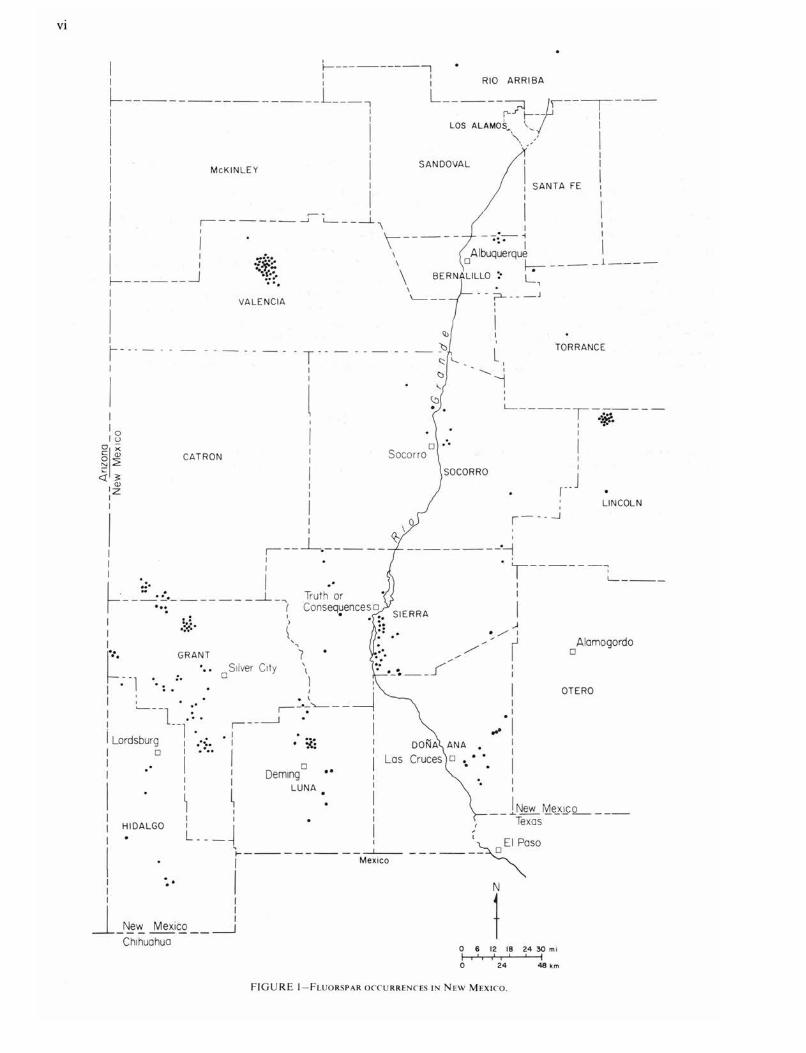
Fluorspar Deposits in New Mexico Although occurrences of fluorspar are known at more
than 200 different places scattered over 15 counties in the western half of New Mexico (fig. l), and small-scale mining has been done on 91 deposits in 11 counties in the state, the aggregate total mine production of all grades is approximately 700,000 tons; shipments of beneficiated product total about 400,000 tons. However, companies, groups, and individuals are actively explor-ing and evaluating several districts at the present time, and chances are good that New Mexico will become an important producer of fluorspar in the near future.
Occurrences are known in the following counties: Bernalillo, Catron, Doha Ana, Grant, Hidalgo, Lincoln, Luna, Mora, Rio Arriba, Sandoval, Sierra, Socorro, Taos, Torrance, and Valencia. The bulk of the produc-tion has come from deposits in Grant, Valencia, Luna, Sierra, and Catron Counties.
Most of the deposits listed below in table 2 have been previously described in excellent papers by Rothrock and others (1946), Gillerman (1964), Williams (1966), and others listed in the references at the end of this paper. Therefore, it is not the purpose of this report to redescribe all occurrences, but rather to update the literature by reporting results of recent detailed studies of certain areas; discoveries not previously reported in the literature; and recent exploration, developments, and mining on new and old deposits.
Modes of occurrence of fluorspar deposits in New Mexico
Most of the known fluorspar deposits in New Mexico are in 1) fissure veins, 2) jasperoid bodies, and 3) bedding-replacement mantos; a few minor occurrences are in breccia pipes and brecciated shear zones and stockworks. Fissure veins, both void-filling and replace-ment, are found in silicic intrusive and intermediate to silicic extrusive igneous rocks, and in carbonate and detrital sedimentary rocks. Fissure vein deposits in Precambrian granites in the Caballo Mountains, Cooke's Range, Burro Mountains, and Zuni Mountains
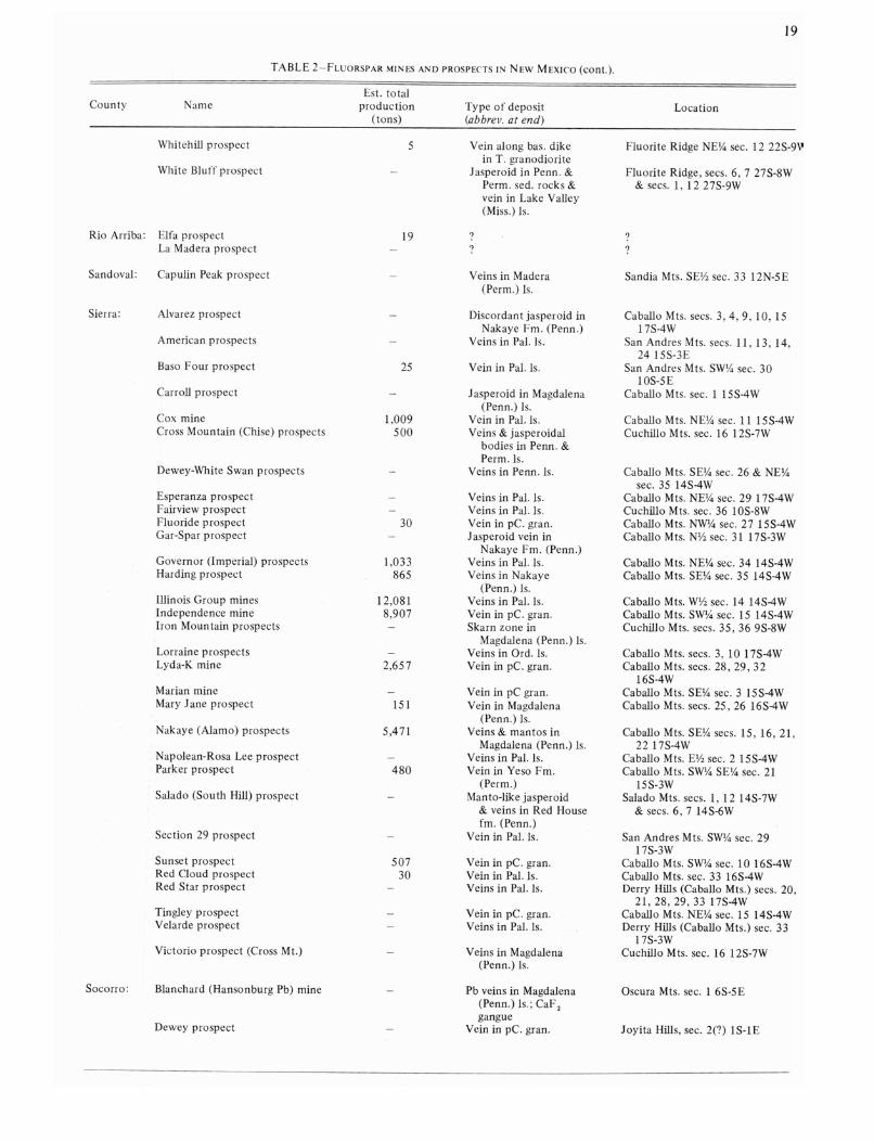
are, or have been, the most important type of deposit both quantitatively and productively in the state. Jasperoid deposits, both concordant and discordant, are widespread and numerous in both sedimentary and igneous host rocks and probably constitute the most important type in terms of future production. Small, concordant bedding-replacement deposits in Pennsylva-nian (Magdalena) limestones in the southern Caballo Mountains have yielded minor production. Table 2 lists the name, total production, type of deposit, and location of most known deposits in the state.
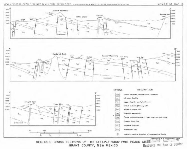
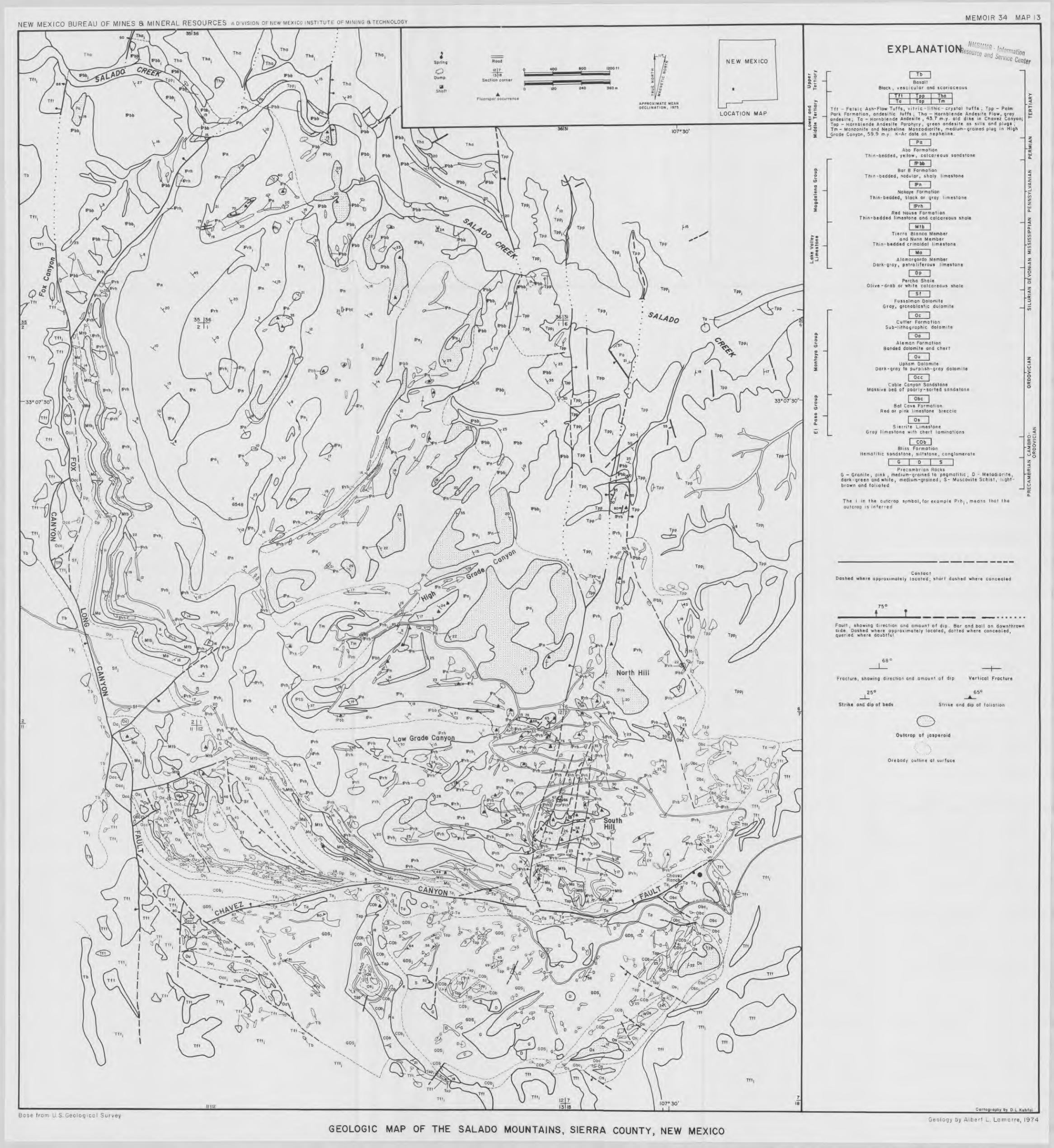
Vein deposits have been the principal source of fluorspar in New Mexico in the past for several reasons: l) they are numerous and widespread in a variety of host rocks, particularly in Precambrian granites in the Caballo Mountains, Cooke's Range, Burro Mountains, and Zuni Mountains; 2) many veins contain void-filling deposits from which a marketable product can be produced with little or no beneficiation by selective mining; 3) such relatively high-grade deposits lend themselves to small-scale mining for a small amount of capital, and 4) there is a lack of beneficiation plants within economic hauling distances of deposits to process low-grade ores. However, it appears that very few of the vein deposits are large enough to supply and amortize even a small beneficiation plant, and larger, low-grade jasperoid deposits are likely to become the principal sources for fluorspar production in the future. Several fluorspar-bearing jasperoid deposits have been mined on a small scale in the past in the Caballo Mountains, but only recently with the discovery of large jasperoid deposits in the Animas and Salado Mountains have such deposits been recognized as potentially important sources of fluorspar.
Catron County Ten fluorspar mines, prospects, and unexplored oc-
currences are known along the faulted, western margin of the Mogollon Mountains in southwestern Catron County (fig. 2). Production totalling about 9,500 tons is


recorded from three mines in the county (table 2). The bulk of the production came from the Huckleberry mine in Little Whitewater Canyon prior to 1955. No fluorspar has been mined in Catron County since 1955. Most of the deposits are in veins in Tertiary volcanic and intrusive igneous rocks. There are a few fluorspar-jasperoid occurrences in andesite in the Holt Canyon area.
A considerable amount of new information has become available in recent years as the result of geologic studies and exploration for fluorspar along the western front of the Mogollon Mountains. Ratté and others (1972) conducted a mineral survey of the Gila Wilderness area for the U.S. Geological Survey and U.S. Bureau of Mines, and Arnold (1974) studied the Little Whitewater Canyon and Holt Canyon areas as an M.S. thesis problem at University of Texas at El Paso. Ira Young and Louisiana Land and Exploration Company explored several fluorspar deposits in the Little Whitewater-Holt segment by drilling.
The faulted, western front of the Mogollon Mountains has many of the geologic requisites for commercial mineral deposits, including favorable structures, intru-sive igneous rocks, favorable host rocks, hydrothermally altered zones, and actual widespread mineralization. However, chances for the area to be properly explored and developed for mining are greatly diminished because of the conflicts and restrictions associated with exploration and mining in and near a Wilderness area. The western boundary of the Gila Wilderness area is down the middle of the mineralized belt (map 1). Relocating the western boundary of the Wilderness area
21
one mile eastward would do little harm to the wilder-ness concept, and it would open up a strongly min-eralized belt for exploration and possible mining of fluorspar.
Huckleberry mine (Whitewater prospect) The Huckleberry mine is located approximately 3.5
mi east of the town of Glenwood in unsurveyed secs. 20 and 29, T. 11 S., R. 19 W. It is near the center of a block of 16 unpatented claims. Access from Glenwood is by way of an unmaintained road up Little Whitewater Canyon. The claims are owned by Felix and Arment Menges of Glenwood and Reserve, New Mexico. Ira Young of Deming holds a lease option on the property.
Production from the Huckleberry mine is reported at 8,500 tons. In 1947 the U.S. Bureau of Mines conducted exploration around the Huckleberry mine, drilling 74 percussion holes and digging several trenches and pits. The results of that project were reported by Sur (1947). In 1972 Ira Young drilled 30 shallow core holes on the Whitewater claims, mainly offsetting earlier drilling done by the U.S. Bureau of Mines. Louisiana Land and Exploration Company drilled two shallow percussion holes near the Huckleberry mine portal in 1974.
GEOLOGY AND FLUORSPAR DEPOSITS—The Whitewater prospect is on the western margin of the Mogollon Mountains, which are composed of a thick pile of Tertiary volcanic rocks (silicic and andesitic) (maps 2 and 3). The Whitewater claims lie astride part of a large, complex fault zone which trends north-northwest for several miles along the western edge of the Mogollon Mountains, generally coincident with their topographic margin. The country rock in the area of the claims is latite lithic-crystal tuff of the Cooney formation, in-truded by discontinuous, east-northeast-trending rhyolite dikes. Fluorite occurs in silicified fault zones and less abundantly in pods and veinlets cutting the rhyolite dikes. At the Huckleberry mine, fluorite is localized along two faults; one strikes east-west and is nearly flat, and the other strikes northwest with a dip of 20° south. The northern third of the Huckleberry deposit is nearly horizontal; the southern two-thirds dips southward about 20 degrees, subparallel to the topography. The orebody ranges in thickness from 3 to 20 ft, and the average thickness is about 10 ft. Another zone of fluorite crops out about 800 ft north of and across the ridge divide from the Huckleberry deposit. At least two fluoritized zones are indicated in that area by outcrops of fluorspar 2 to 16 ft wide along silicified faults which dip 40 to 61 degrees eastward.
Drill-indicated proven reserves on the Whitewater prospect (Huckleberry mine area) are about 40,000 tons of 30 percent CaF2; additional probable reserves are about 20,000 tons in the southern zone and 25,000 tons in the northern zone. However, actual minable reserves may not exceed 40 percent of the ore present, since the deposits are in relatively narrow, nearly flat veins near the surface.
The fluorspar in the Huckleberry mine deposit is the result of both open-space filling and replacement of fault breccia and a rhyolite dike. Thin sections reveal that the rhyolite dike was replaced by fluorite. Two periods of silicification and fluoritization can be recog-nized in thin sections of the ore. Fluorite coats joints

22
and fractures in the mine area and in fault zones north of the mine. The fluorite is fine to coarse crystalline and exhibits a variety of colors, including green, white, and purple. The gangue consists principally of quartz, calcite, and unreplaced country rock.
Fluoritization associated with the known fluorspar deposits on the Whitewater property and possibly com-mercial fluorspar deposits extend eastward into the Gila Wilderness area. Mining and exploration of the property probably will be hampered in the future by restrictive mining regulations designed to protect Wil-derness areas.
Shelton Canyon prospects Two groups of prospect pits about 325 ft apart, near
the bottom of Shelton Canyon (just west of the Gila Wilderness boundary), expose fluorspar in veins up to 3 ft wide in andesite host rock. The veins are along faults striking N. 5°-35° W. and dipping 50°-70° NE. The CaF2 content of the veins is estimated at 40 to 60 percent; quartz is the principal gangue mineral.
Little Spar prospects The Little Spar claims are located in the area between
Shelton Canyon and Holt Gulch in secs. 28, 33, 34, T. 11 S., R. 19 W. They are owned by Jimmie and Ruby Zook of Truth or Consequences, New Mexico. Fluorspar, exposed in several shallow prospecting pits, occurs as fracture filling and breccia cement along faults striking N. 10°-30° W. in andesite. Green and purple fluorite is present in veins 6 inches to 1 ft in thickness. The gangue consists of quartz and calcite, with quartz being the major constituent.
Holt Group (claims 13, 14, and 15) The best fluorspar outcrops in the area between Little
Whitewater Canyon and the Goddard Canyon area are on the north slope of Holt Canyon, about 500 ft east of the Gila Wilderness area boundary, sec. 34, T. 11 S., R. 19 W. The country rock is gray andesite. Old workings in the area include the dilapidated remains of a 1 ft by 2 ft wooden ore chute trough which extends about 200 ft up the north slope of Holt Gulch to an old adit driven along a fluorite vein in a fault zone trending N. 35° W. for about 30 ft. The vein pinches rapidly and is only 2 inches wide at the end of the adit. About 1,400 ft north of this adit is another adit developed along a fault striking N. 40° W. and dipping 70° SW. Fluorspar exposed in this working occurs as cement in breccia and in a weak stockwork.
The principal fluorspar shows are along faults striking N. 35°-40° W. and dipping 60°-70° NE., in a stockwork zone 100 to 300 ft wide and at least 600 ft long across the north slope of Holt Gulch, beginning about 100 ft above Holt Creek. The fluorite occurs as breccia cement, coating on joints and fractures, and in veins and veinlets. Some veins are up to 3 ft wide, but most of them are less than 6 inches wide. Several of the wider veins are traceable for 100 ft or more before they either begin to pinch out or end abruptly. The vein density within the zone ranges from 1 to 15 per ft. Fine-grained quartz and minor amounts of calcite are usually intermingled with fluorite in the veins; the quartz content appears to increase northward (Arnold, 1974, p. 46).
There are two other old adits in Holt Gulch inside the Wilderness area. A small amount of fluorspar is present in the dumps from these workings.
Holt Group (claims 16, 17, and 18) The Holt claims, Nos. 16, 17, and 18, located in sec.
34, T. 11 S., R. 19 W., are owned by Felix and Arment Menges of Glenwood and Reserve, New Mexico. They were leased to Ira Young in 1972. Young drilled 11 percussion holes, 30 to 50 ft deep, along a fault in Holt Gulch (fig. 3). Assay values for composite samples collected from drill cuttings from the holes are shown in table 3. Rocks exposed in Holt Gulch in the area of the claims include gray andesite, overlain by purple andesite and flow-banded rhyolite. Rhyolite dikes striking east and northeast and a major fault striking N. 30° W. cut the andesite and canyon directly north of Holt Cabin. The rhyolite dikes, 5 to 50 ft wide, are exposed over a distance of 600 ft. Fluorspar occurs sporadically along the rhyolite dikes in veins and veinlets and as fracture coatings. Locally, the host andesite along the contact zone contains small stockworks of fluorspar veinlets. Quartz and calcite are the principal gangue minerals.
In the area drilled by Ira Young, fluorspar occurs as breccia cement, void-filling, and replacement in and near the intersection of an east-trending rhyolite dike and a fault which strikes N. to N. 15° E. and dips 85° W. Fluorite in the fault zone is white and green, fine to coarse crystalline, and intermixed with quartz; the silica

content ranges from 57 to 79 percent; CaF2 from 8 to 27 percent; and calcite from 1 to 14 percent. Fluorspar crops out continuously along the fault for about 500 ft to a point where the strike of the fault turns more northerly; beyond that point, fluorspar shows continue sporadically for a quarter of a mile.
Morning Star prospect The Morning Star claim, located in sec. 4, T. 12 S., R.
19 W., is part of a block of claims held by Ira Young under a lease from Felix and Arment Menges.
An old 10-ft adit reveals fluorspar filling open spaces in gray andesite along a fault which strikes N. 22° E. The fault is traceable for a distance of about 1,100 ft northwestward to Gold Hill, but mineralization decreases away from the site of the old workings. Several quartz veins up to one foot wide crop out near the old working and on Gold Hill.
Red Shaft prospects The Red Shaft is on Holt No. 2 claim, located in sec.
5, T. 12 S., R. 19 W. The shaft, now caved, is reported to have been sunk to a depth of 400 ft in search of gold. It is located about 100 ft north of a rhyolite plug from which silicic dikes 5 to 50 ft wide radiate outward through gray andesite. Fluorspar occurs in the rhyolite and in a weak stockwork in the adjacent andesite.
A normal fault striking N. 10° E. cuts the west end of the Red Shaft rhyolite plug, and the intrusion is strongly fractured near the fault. There is evidence of cauldron subsidence, which also produced fractures in the central part of the intrusion. Fluorite fills fractures, and where brecciation was intense minor replacement of the rhyolite occurred. About 35 ft below the top of the intrusion, a vein of coarse-crystalline fluorite ranging from a few inches to 5 ft in thickness has a strike length of about 400 ft along the base of the sagged area. Ira Young drilled 10 percussion holes (fig. 4) in and near the rhyolite plug in 1972, and, according to Young (Arnold, 1974, p. 47), the fluorspar content of the cuttings from the holes ranged from 15 to 25 percent. The contact zone possibly warrants additional explora-tion.
Goddard Canyon prospects Minor amounts of fluorite are exposed in several
prospect pits located along faults and silicic dikes in Tertiary andesite and rhyolite in the Goddard, Red Colt, and Wilcox areas south of Holt Canyon, but
apparently relatively little prospecting has been done. Brief reconnaissance of those areas revealed that geo-logic relationships are favorable for fluorspar and other minerals.
Dotla Ana County Fluorspar occurrences are known in 13 areas in Doña
Ana County—six in the Organ Mountains, two in Tortugas ("A") Mountain, one in San Diego (Tonuco) Mountain, and four in the San Andres Mountains (fig. 5). Production has been recorded for six of the deposits, with the Tortugas and Tonuco mines accounting for the bulk of the production (20,751 tons and 7,720 tons, respectively). No mining is in progress at the present time.
A few tons of fluorspar were produced from a prospect in the Bishop Cap area in 1969-72, and exploration has been done during the past five years at several places in the Bishop Cap area and around the Ruby (Hayner) mine on the west side of the Organ Mountains. The Bishop Cap area was the subject of a M.S. thesis completed in 1970 by Walter V. Kramer; a M.S. thesis by Thomas J. Glover, dealing with the geology and mineralization along the western margin of the Organ Mountains, was completed in 1975. Discus-sions of these areas follow.
Bishop Cap Hills district The Bishop Cap Hills district covers about 7 sq mi
near the southwestern margin of the Organ Mountains,

approximately 15 mi southeast of Las Cruces. These hills, the highest of which is Bishop Cap (elevation 5,419 ft above sea level and about 900 ft above the valley floor), are erosional remnants of blocks produced by five high-angle normal faults. The Bishop Cap Hills and Tortugas Mountain near the southeast edge of Las Cruces may be erosional remnants of the western and southwestern rim of the Organ Mountains caldera (fig. 6). Fluorspar is present in both areas, as it often is in rims of resurgent calderas in Texas, Mexico, and elsewhere. Mineralization consisting of fluorite, barite, calcite, and cryptocrystalline quartz (jasperoid) is wide-spread through most of the sedimentary section, and particularly in the Fusselman Dolomite (Silurian), Canutillo (Devonian), Rancheria (Mississippian), and La Tuna (Pennsylvanian) Formations. Small deposits occur in narrow veins along steep normal faults and in brecciated, jasperized zones along bedding-plane faults.
Both void-filling and replacement contributed to the formation of the deposits.
HISTORY OF DISTRICT—Fluorspar was discovered in the Bishop Cap Hills in the early 1900's. Ladoo (1927) noted fluorspar in narrow veins in a few shallow test pits and trenches, but, according to him, no fluorspar from the deposits had been sold up to that time. Approximately 100 tons of fluorspar from a small adit on the SW¼NW¼ sec. 25, T. 24 S., R. 3 E. were shipped for metallurgical testing in 1944. The U.S. Bureau of Mines investigated the area in 1945 by excavating and sampling 15 trenches, assaying, and making beneficiation tests on the ore. It was their conclusion that the veins were too thin and too low in grade to be of commercial value (Sur, 1946). According to Williams (1966), a shipment of 12 tons of fluorspar from the Blue Star prospect (S½NE¼NW¼ sec. 25, T. 24 S., R. 3 E.) was made in 1954. A small amount of subgrade fluorspar was mined from the Grant prospect (NW¼ sec. 25, T. 24 S., R. 3 E.) and sold to Border Steel Company, El Paso, Texas, for use in an electric furnace in 1969-72.
A limited core-drilling program on the Blue Star claims in 1969-70, supervised by the writer and financed by the Rangaire Corporation, Cleburne, Texas, failed to find commercial deposits. Most of the district is currently controlled by Allied Chemical Corporation; Allied drilled several percussion holes in the south-central

part of the area in 1975 and found appreciable low-grade mineralization.
GEOLOGY—The Bishop Cap Hills are separated from the main mass of the Organ Mountains by a valley developed on a major northwest-trending fault. More than 2,500 ft of Paleozoic sedimentary rocks, ranging in age from Ordovician to Pennsylvanian, are exposed in the area (table 4). Approximately 27 percent of the exposed strata is limestone, 36 percent dolomite, and 27 percent shale; no igneous rocks are exposed in the hills (map 4).
As previously mentioned, the hills are erosional remnants of five large fault blocks. Four of the fault blocks were formed by north-trending, steeply east-dipping normal faults; strata in these blocks dip westward. The fifth block was produced by an east-trending, high-angle, north-dipping normal fault; strata in this block dip northwestward. Stratigraphic displacements along these faults range from 900 to 2,500 ft. The larger fault blocks are cut by numerous minor faults and fractures along which much of the mineralization occurs.
The most important minor fault in the district is the Blue Star fault. It is a long curved normal fault that controlled much of the principal mineralization. A segment of the fault plane is well exposed in the vicinity of the Blue Star prospect (S½NE¼NW¼ sec. 25, T. 24 S., R. 3 E.). It dips 50°-70° N. at that place. Displace-ment along the Blue Star fault ranges from 400 to 600 ft, with the upthrown side being on the south and/or west. Most of the minor faulting in the hills appears to be related to the Blue Star fault.
MINERALIZATION AND FLUORSPAR DEPOSITS—Fluorite, barite, cryptocrystalline quartz (jasperoid), and calcite are widespread throughout the district. Minor amounts of pyrite, hematite, galena, chalcopyrite, azurite, mala-chite, and unidentified uranium minerals occur in a few places. The mineralization is localized in fissure veins along faults and fractures and in irregular-shaped jasperoidal replacements in brecciated zones along fractures and bedding-plane faults.
Varying amounts of fluorite are present in strongly
25
mineralized areas. In typical outcrops the fluorite is in the form of massive, crystalline pods. Coarse-crystalline fluorite fills or partially fills voids in fractures and brecciated jasperoid masses. Most vein and jasperoid material contains some fine-grained, replacement fluorite that is difficult to recognize with the unaided eye. Limestone is replaced or partially replaced to a limited extent by fine-grained fluorite in places along some veins and bedding-plane faults. The principal gangue minerals are cryptocrystalline quartz, calcite, and barite.
In most places barite (BaSO4) occurs in subordinate amounts along with fluorite and the gangue minerals. However, high-grade pods of barite occur in a few places, particularly in the Fusselman Dolomite along the Blue Star fault on the Blue Star prospect. Generally, barite fills voids and cements breccias; it rarely replaces the host rock. It commonly occurs in the form of clear to white orthorhombic plates and crystalline rosettes scattered through the mineralized material.
Silicification is extensive in the area, and practically all of the fluoritization is associated with it. Irregular-shaped jasperoid masses are common, especially in the Fusselman Dolomite in faulted and brecciated zones. Many veins in the area consist principally of jasperoid and probably served as feeders for silica-rich fluids that effected the jasperization there and in other places. Dolomites and limestones in the Canutillo Formation and the Magdalena Group are silicified in many places, particularly the upper part of the Canutillo immediately beneath the overlying Percha Shale. Limestones in the Lake Valley and Rancheria forma-tions are extensively silicified also.
Calcite (CaCO3) is an abundant gangue mineral in the fault zone deposits; ferruginous and manganiferous varieties are common. It occurs in the form of small rhombohedrons, large dogtooth scalenohedrons, and coarse anhedral masses. Calcite and barite are in-timately intermixed in the fault zone deposits.
Dunham (1935) pointed out an apparent crude zonal arrangement surrounding the Organ stock or batholith. Outward from the large intrusion of quartz monzonite are successive zones of copper, zinc, lead, barite, and fluorite. Deposits in the Bishop Cap Hills are characteristic of an outer zone.
Large commercial deposits of fluorspar have not yet been found in the Bishop Cap Hills, but small deposits crop out at many places in several different formations throughout the district. The principal known deposits are concentrated in the north half of sec. 25, T. 24 S., R. 3 E.—Grant's prospect in the NW¼, and the Blue Star prospect in the NE¼.
Grant's prospect was described as the Bishop Cap deposit by earlier workers (Johnston, 1928; Rothrock and others, 1946; Sur, 1946; and Williams, 1966). It is herein called Grant's prospect because the claims are currently owned by J. F. Grant of Las Cruces, New Mexico.
Grant's prospect is located in a highly faulted area south of the Blue Star fault (map 5). At least three northwest-trending faults and one north-trending fault cut the area. The mineralization occurs along faults in the Fusselman Dolomite. Exploration on the Grant claims consists of 9 short adits, 6 shallow test pits, and numerous trenches in fault zones. Most of the explora-

26
tion was done by the U.S. Bureau of Mines in 1945. Four of the adits and several trenches are located on the north-trending fault A (map 5). Rothrock and others (1946) reported that 3- to 4-ft thicknesses of fluorspar occur in the fault A zone for more than 1,200 ft along the strike. The Fusselman Dolomite forms the footwall, and the hanging wall is the Canutillo Formation. Most of the fluorite occurs as open-space filling in breccia along the footwall; ferruginous and manganiferous calcite with some barite and fluorite are present along the hanging wall. The vein pinches and swells both downdip and along the strike. Several small fluoritized veins and pods occur along the other faults in the area.
A composite sample taken from the Grant's prospect for a beneficiation test by the U.S. Bureau of Mines in 1945 contained 47.5 percent CaF2 , 23.5 percent SiO2 , 14.9 percent CaCO3 , and 11.1 percent BaSO4 . The concentrate made contained 98.2 percent CaF2 and 0.5 percent SiO2, with recovery being 82.3 percent (Sur, 1946).
The Blue Star prospect lies astride the Blue Star and other faults (map 6) in the NE¼ sec. 25, T. 24 S., R. 3 E., on the Blue Star group of claims owned by Fred C. Leach and others. This area has been partially explored by two short adits, several test pits, and 753 ft of coring. The principal mineralization occurs along a group of minor faults which branch off southward from the Blue Star fault at angles of about 30 degrees, and in a second area of minor faulting located about 400 ft south of the first, parallel to the Blue Star fault. Most of the mineralization is in jasperoid in the Fusselman Dolomite. Barite appears to be more abundant in this area
than elsewhere in the district. Although fluoritization is widespread over the Blue Star claims, the known deposits are small and noncommercial. However, there is a possibility that more drilling would discover larger deposits.
Small outcrops of fluorspar are known at several other places in the Bishop Cap Hills, some of which may merit exploration, particularly occurrences in and around Conklings Cave (sec. 25, T. 24 S., R. 3 E.). A fluorite vein about 100 ft long and 2 ft wide which forms the western wall of the cave has been explored by two interconnected shafts about 50 ft deep and two trenches, revealing appreciable fluorspar and calcite. A large mass of barite is partially exposed in a shallow trench located about 400 ft north of Conklings Cave. The barite is on or near a major fault. East of and below Bishop Cap Peak, a small replacement zone in the Rancheria Formation contains barite, fluorite, pyrite, quartz, and unidentified radioactive minerals immediately below the contact with the overlying Helms Formation.
Ruby (Hayner) mine The Ruby or Hayner mine is located in the NW¼
sec. 25, T. 22 S., R. 3 E., Doña Ana County, New Mexico. It is 17 mi by road northeast of Las Cruces, on the west flank of the Organ Mountains. It may be reached from US-70 by taking a ranch road southward at a point 3¼ mi southwest of the town of Organ.
Frank M. Hayner located three contiguous claims in the area in 1926—Ruby, Live Oak, and Gloria (fig. 7). These claims were patented later. The total production

recorded from the property is 400 tons of fluorspar in 1933. Only the Ruby and Gloria claims are assessed and taxed at the present time. They are owned by Mrs. Audria Hayner Palmer of Las Cruces. The Cougar Fluorspar Corporation holds a lease on the claims and, reportedly, is preparing to mine the fluorspar.
GEOLOGY—Fluorspar occurs in a series of six sub-parallel fissure veins in the Hueco Limestone (Permian) and in a Tertiary andesite dike on the lower west slope of the Organ Mountains, near the contact with the Organ Mountain batholith of quartz monzonite (fig. 8). The veins strike approximately N. 20° E. and dip 50°75° E. Eight additional fracture zones containing minor amounts of fluorite are exposed in underground working on the property. The Hueco limestones are moderately to intensely chloritized and epidotized (Glover, 1975, p. 72).
The CaF2 content ranges from about 20 percent to 70 percent, the average being about 30 percent. Most of
27
the fluorite was precipitated in available open spaces in the fissure veins; minor replacement fluorite occurs in brecciated zones. The fluorite is fine- to coarse-grained, and is white, pale green, and purple. The vein material includes quartz on each side, and alternating bands of calcite and fluorite in the central portion with trace amounts of barite.
Glover (1975, p. 72) gave the dimensions of the veins as follows:


DEVELOPMENT—Glover (1975, p. 74) described the exploratory and development workings as follows:
The principal workings consist of open stopes, trenches, and drifts on Veins 2, 3, and 6. Most of the work was done prior to 1943. Vein No. 2 has been trenched along the strike for 80 feet (24 m) and to a depth of approximately 20 feet (6 m). Vein No. 6 has been worked by 25-, 32-, and 55-foot adits, all parallel to the strike. The principal workings of the Ruby mine are on Vein No. 3. It was worked by adits on two levels in the early stages of development, and later the bottom level was stoped to the surface. The workings consist of an open stope 160 feet (49 m) along the strike of the vein and to a depth of approximately 50 feet (15 m). Exploratory work between 1973 and 1975 consisted of sinking a 95-foot (29 m) incline shaft on Vein No. 3 and drifting east 595 feet (181 m). This tunnel cuts all the veins except Vein No. 1.
A well-planned exploration program, including core drilling, careful sampling, and good analytical work might result in discovery of a few thousand tons of medium-grade fluorspar on the Ruby property. It is the writer's opinion that some promotional reports in circulation contain unrealistic reserve estimates and report much higher grades than can be mined from the narrow vein deposits.
Fillmore Canyon prospect A fluorspar occurrence not previously reported in the
literature, located in NW¼ sec. 6, T. 23 S., R. 4 E., in Fillmore Canyon on the west slope of the Organ Mountains, is herein called the Fillmore Canyon pros-pect. The fluorspar outcrop is approximately 200 ft south of the old Orejon lead mine. It is on an unpatented claim, the Orejon, owned by Daniel J. Ford, Las Cruces, New Mexico.
Fluorspar occurs in limestone in the Hueco Formation (Permian) in small pods and replacements associated with jasperoid in the footwall of the Modoc fault. The fluorite is fine to medium grained and is intimately associated with cryptocrystalline quartz. The mineral-ized zones also contain some andradite garnet, calcite, specularite, and limonite.
Grant County More than 40 percent of the fluorspar produced in
New Mexico has come from deposits in Grant County. Production has been recorded from 33 of the 50 known mines and prospects in the county (table 2). Five of the 12 mines in the state with production of more than 10,000 tons are in Grant County (table 2). However, there is no production in the county at the present time.
Deposits in Grant County are known in northern Cooke's Range, the Burro Mountains, Mogollon Moun-tains, Pinos Altos Mountains, and the Steeple Rock-Twin Peaks area (fig. 9). Most of the known occurrences are in veins in Precambrian granites and metamorphic rocks; however, several are in veins in andesite, latite, rhyolite, quartzite, and quartz monzonite of Tertiary age, and a few are in veins in Paleozoic limestones.
Most of the deposits listed in table 2 have been described by Rothrock and others (1946) and Williams (1966), and only those which have been restudied or explored since 1966 are discussed in this report. These
29
include the White Eagle mine and the Linda Vista-Wagon Tire prospects studied by Richard W. Morris as a M.S. thesis problem in geology at University of Texas at El Paso, and later explored by Louisiana Land and Exploration Company; the Great Eagle mine explored by Allied Chemical Corporation; the Mohawk mine, Black Willow prospect, Powell prospect, and Leta Lynn prospect in the Steeple Rock-Twin Peaks area studied as a M.S. thesis problem by Brad P. Biggerstaff (1974); and the Clum mine explored by Letrado Exploration Company of Santa Fe, New Mexico, in 1972.
White Eagle mine The White Eagle mine is located about five miles
north of Cooke's Peak, in sec. 34, T. 19 S., R. 9 W., approximately 32 mi north of Deming, New Mexico. Access from Deming is from US-180, NM-61, and about 13 mi of good ranch road. The White Eagle property consists of 1 patented claim, 8 unpatented claims, and 3 fractional unpatented claims.
The White Eagle deposit was first worked prior to 1918, and the aggregate total of intermittent production through 1972 is 62,300 tons of metallurgical grade fluorspar. Ownership has changed hands several times during its history. Various lessees operated the mine for short periods of time in the 1930's and 1940's. The U.S. Bureau of Mines explored the property by diamond drilling in 1945 (Soule, 1946). Finley Dunegan and Hiram Harrison of Deming, New Mexico, purchased the claims in 1945. In the summer of 1950, the Ozark-Mahoning Company of Tulsa, Oklahoma, leased the property and mined 12,300 tons of fluorspar, averaging 61.7 percent CaF2 (Williams, 1966, p. 35) during 1953-54. They dropped their lease in 1959, and• there was no activity at the mine for ten years. From 1969 to 1972, Southwest Fluorspar Company (Bishop Bailey) held a lease on the claims and mined 5,500 tons of fluorspar from pillars and previously developed stopes. Ira Young of Deming leased the property in 1972 and explored the vein trend by means of several bulldozer trenches and shallow percussion drill holes. Young subleased, with an option to purchase, to Louisiana Land and Exploration Company in 1973. Louisiana Land and Exploration Company drilled 5 diamond core holes on the vein trend in 1974 and dropped their option in 1975.
Most of the mine development work was done by Ozark-Mahoning Company during 1953-54. The mine has been developed along a steeply-dipping fissure vein by opencut and underground methods. The underground mining was done by both underhand and shrinkage stoping down the dip of the vein. A few pillars were left to support the walls, and the shafts were deepened as mining progressed. Two shafts were used: Shaft No. 1 bottomed at a depth of 550 ft below the surface, and Shaft No. 2, located about 300 ft southeast of Shaft No. I, bottomed at a depth of 235 ft. Mining and development work was done at levels of 150, 220, 420, and 520 ft. The average stope width is about 5 ft; however, widths up to 27 ft were mined between 220 and 420 ft. The 150-ft level is inaccessible at the present time, and the lower part of Shaft No. 1, including the 520-ft level, is flooded to within a few feet below 420 ft. There are about 2,000 ft of drifts in the mine.

30
GEOLOGY AND FLUORSPAR DEPOSITS—The White Eagle mine is in a north-northwest-trending horst block about ½ to 3/4 mi wide, composed of Precambrian granite intruded by numerous dikes and irregular-shaped bodies of rhyolite and andesite of Tertiary age. A down-faulted block containing Fusselman Dolomite, Percha Shale, and Lake Valley Limestone is faulted against Precambrian granite immediately northwest of the mine and the fluoritized trend. Tertiary volcanic and continental sedimentary rocks bound the horst block of Precambrian granite on the east and west sides (map 7).
The fluorspar occurs in a series of fissure veins and veinlets in a zone which strikes N. 55° W. and is nearly vertical in Precambrian granite. Two facies of granite crop out in the vicinity of the White Eagle mine—one fine grained and the other medium grained. Several small quartz-microcline pegmatites and narrow aplite dikes cut the granites near the mine. The granite is strongly altered within and along either side of the vein zone.
The granite is cut by tabular and irregular-shaped bodies of porphyritic rhyolite ranging from 6 to 20 ft in thickness. Phenocrysts in the rhyolite consist of small grains of K-feldspar and "quartz eyes." The rhyolite exhibits some flow banding and contains rounded inclusions of granite near contacts with the granite host. A brecciated and silicified rhyolite dike parallel to the vein zone near the mine contains considerable fluorspar. Andesite dikes also cut the granite, and two types of altered andesite are exposed in the mine workings—the older being grayish blue-green and the younger greenish black. The younger andesite is partially replaced by fluorite at places in the mine. Andesite also crops out in an area southeast of the mine.
Fluorite in fissure veins and wallrocks in the White Eagle fault zone is fine granular to coarsely crystalline and is green, purple, and white. The gangue consists principally of calcite, quartz, and altered wallrock. The fluorspar was formed by both void filling and replace-ment processes. Almost all of the production came from one vein, and most of the mine workings are in that vein. One main vein and two smaller, subparallel veins crop out and are exposed in the upper mine workings. The veins die out along strike on the surface to the northwest in rhyolite and limestone. Below the 220-ft underground level most of the fluorite veins and all of the wide stockworks are in andesite. Several large veins and fluoritized stockworks adjacent to them are exposed in crosscuts on the 420-ft level and in wide stopes on the 320- and 220-ft levels in the mine. Fluorspar widths up to 20 ft were mined on the 320-ft level, and a zone up to 50 ft wide containing 30 ± percent CaF2 is exposed on the 420-ft level. Drilling done by Louisiana Land and Exploration Company indicated downdip extension of the vein zone to at least the 700-ft level. However, strike extensions of the vein zone do not appear to be much greater than the present lateral extent of the workings. The depth to which minable fluorspar extends remains to be determined. Proved reserves in the White Eagle vein zone amount to 79,500 tons of about 60 percent CaF2. This includes fluorspar blocked out in the existing mine workings and extension of the vein as indicated by drill holes. Probable ore in a block peripheral to the proved ore totals about 55,750 tons of 40 percent CaF2.
Approximately 43,500 tons of vein ore are blocked out in existing mine workings between the surface and the 520-ft level, extending outward from the shaft from 60 to 340 ft. This ore contains an average of 60 percent CaF2. The vein width ranges from 4 to 24 ft and averages 6 ft. Drill holes beneath existing workings delineated a block of 36,000 tons containing about 40 percent CaF2. This block is 400 ft wide and extends downward from 130 to 230 ft below the 520-ft level, with an average vein width of 6 ft.
Potential reserves are large in the White Eagle area, particularly if several prospective areas extending several miles northwest of the mine are included. Several blind veins were encountered in drilling at the White Eagle mine. One blind vein intercept of 25 ft contained an average CaF2 content of 30 percent. Other narrow veins were intersected in limited crosscutting done in the past. Fluorite veins in granite crop out over a sizable area about one mile northwest of the White Eagle mine.
Linda Vista-Wagon Tire and other prospects in northern Cooke's Range
The old Linda Vista, Wagon Tire, and several other claims cover most of S1/2 sec. 21, T. 19 S., R. 9 W., about 2 mi northwest of the White Eagle mine. Access from Deming is via US-180, NM-61, and about 15 mi of good ranch road. There are several groups of claims in the area, most of which are reportedly owned and/or controlled by Carl Rogers of Silver City, New Mexico. Most of the old Linda Vista and Wagon Tire claims have been restaked and are now in the Rainbow group of claims. Linda Vista Nos. 1, 2, and 3, and Buena Vista Nos. 1, 2, and 3, and Wagon Tire Nos. 1 to 5, owned by P. L. Gratton in 1944, were previously worked by D. F. McCabe (Williams, 1966, p. 34). A third group was owned by Baca and Whitehill in 1944. A considerable amount of prospecting was done earlier by unknown prospectors. Shallow test pits and trenches are scattered all over the area.
According to Williams (1966, p. 35), production in small lots from 1948 to 1953 totalled about 1,500 tons, of which 1,231 tons came from the Linda Vista mine. Other production in the area came from several shallow pits and open cuts. Several test pits, shallow shafts, trenches, and short adits are scattered over several hundred acres. No large-scale mining was ever done in this area. The largest workings, centered around the Linda Vista mine (map 7), consist of an open cut about 300 ft long and 10 to 20 ft deep, and a shaft about 80 ft deep. A considerable footage of percussion drilling has been done during the past few years, but the drilling data were not available.
GEOLOGY AND FLUORSPAR DEPOSITS—Precambrian granites exposed in the area of the White Eagle mine are covered by an extrusive volcanic formation of Tertiary age in the Linda Vista-Wagon Tire area (map 8). Elston (1957, p. 39) identified the igneous rock that hosts most of the fluorspar deposits as intruded monzo-nite or granodiorite porphyry. Morris (1974, p. 11) called the rock andesite. The strongly argillized, serici-tized, and chloritized condition of the rock prevents a clearcut identification. Almost all of the original ferro-magnesian minerals have been destroyed, as well as all

primary structures. The andesite is jasperized at several places adjacent to silicic (rhyolite?) dikes.
Fluorite crops out at many places over several tens of acres in the Linda Vista-Wagon Tire area. Fluorspar deposits in the form of veins, veinlets, stockworks, and replacements of andesite are exposed in numerous workings. Irregular-shaped masses of jasperized andes-ite and rhyolite containing fluorite are scattered over the claims. A layer of high-grade fluorspar, 6 inches to 3 ft thick, is exposed in the cut at the Linda Vista mine. Chances are good that replacement fluorspar deposits occur at depth in contact zones between the altered andesite and intrusive silicic dikes. The area merits further exploration. Combined reserves in the Linda Vista-Wagon Tire and White Eagle deposits may be large enough to support a full-fledged mining and milling operation.
Great Eagle mine and vicinity The Great Eagle mine is located on the south side of
the Gila River, 27 mi north of Lordsburg and about 5 mi northeast of Redrock post office, in the SW¼ sec. 23, T. 18 S., R. 18 W. Another sizable fluoritized area with commercial potential, located in the NE¼ sec. 22, T. 18 S., R. 18 W., is herein called the McCauley zone. The properties consist of 6 patented claims owned by Mrs. Ruth Spann and Mrs. Lucille Schnable of Lampasas, Texas, and 5 unpatented claims owned by Tom McCauley and Sons, Inc. Tom G. McCauley of Cliff, New Mexico, holds a 15-year lease that began August 26, 1974, on the patented claims.
According to Hewitt (1959, p. 117), A. B. Conner of Redrock claimed the property on which the Great Eagle mine is located in 1911 and worked it until 1914. The property was then acquired by J. H. Cauthen of Lampasas, Texas. Mining was resumed in 1918 by the Great Eagle Mining Company. A mill was erected near the mine in 1919 to produce ground fluorspar, but it was unable to treat the siliceous ore satisfactorily and was soon dismantled. Mining was stopped in 1921. The Fluorspar Milling Company reopened the mine in 1939, and it was worked until 1941 by the Southwestern Mining Company. D. F. McCabe of Lordsburg leased the property in 1943 and sold several thousand tons of ore from the old dumps. The mine has been closed since 1945. The aggregate total of all production from the mine is 15,215 tons.
The geology and fluorspar deposits in the area have been described by Johnston, 1928; Rothrock and others, 1946; Hewitt, 1959; Gillerman, 1964; and Williams, 1966. New information given in this report was obtained from reports prepared by Herbert Daniel, Geologist for Allied Chemical Corporation, which summarize extensive exploration of the area by Allied during the period October 1974 through April 1975.
Allied's exploration of the Great Eagle vein and other deposits nearby included 6,724 ft of diamond coring in 29 holes, 2,700 ft of percussion drilling in 44 holes, 240 ft of drifting on the Great Eagle vein, and plane-table mapping of the area. According to Allied's calculations, reserves in the amount of 195,324 tons of ore containing 43.1 percent CaF2 were indicated by their drilling. Allied decided not to take up their option on the property and returned it to Tom McCauley. McCauley
31
is presently making preparations to mine the southern part of the Great Eagle deposit and produce a high-
grade metallurgical product by processing mine-run ore through a heavy-media plant to be installed near the mine. Preliminary testing of bulk samples in a heavy media plant indicates that a 72½ percent effective grade can be produced. McCauley believes that a minimum of 100,000 tons amenable to heavy-media treatment can be mined from the southern part of the Great Eagle vein.
GEOLOGY—For detailed information about the geol-ogy of the northern Burro Mountains and the Redrock area, the reader is referred to papers by Hewitt (1959) and Gillerman (1964). A brief summary of the geology in the immediate vicinity of the Great Eagle fluorspar deposits follows.
The Great Eagle deposits and other occurrences of fluorspar nearby are in the Precambrian Burro Moun- tain granite, marginal to a major fault which juxtaposes the granite and the Gila Conglomerate. The bounding fault is somewhat arcuate, striking N. 60° W. and dipping steeply southwestward on the northwest side of the river. The Great Eagle fluorspar veins occupy a curving shear zone, about 3,500 ft long on the surface, which varies in strike from N. 35° W. to N. 51° W., and dips about 85 degrees southwestward in places and 59 degrees northeastward in other places. This shear zone is cut off on the southeast by the major bounding fault mentioned above. It dies out northwestward and finally gives way to an aplite dike.
The Gila River has cut a narrow canyon about 200 ft deep nearly normal to the trend of the Great Eagle shear zone. The granite within the shear zone is strongly argillized and moderately silicified over a width ranging from 30 to 150 ft. The strongest alteration and best fluorite veins are in the southeastern segment of the shear zone, on the south side of the river.
Another fluoritized area, the McCauley zone, is present in Precambrian granite and in Cretaceous sandstone marginal to the bounding fault on the northwest side of the Gila River, NE¼ sec. 22, T. 18 S., R. 18 W., immediately north of the McCauley camp. The fluoritized zone is about 1,500 ft long and 100 to 300 ft wide, with the long dimension being roughly parallel to the bounding fault. This zone is strongly brecciated and cut by several northeast-trending minor faults and fractures.
Rhyolite and andesite dikes are numerous in the general area, but none was observed within the fluori-tized zones.
FLUORSPAR DEPOSITS—Fluorite occurs in irregular veins and breccias within a zone 10 to 40 ft wide in the Great Eagle shear zone. The mineralized part of the shear zone contains several veins which range in th ickness f rom 2 to 15 f t and average about 5 f t in thickness. Where veins intersect, the thickness may be as much as 15 to 20 ft. Allied's drilling indicated that veins of minable grade and thickness extend to a depth of about 200 ft; below 200 ft, the silica content increases rapidly. The fluorite in the veins is medium to coarse crystalline and ranges from colorless to pale green to deep green to purple. In some places the veins are composed of outer layers of greenish fluorite and an inner layer of purple fluorite. In other places coarse-

32
crystalline layers of green fluorite alternate with layers of fine-grained fluorite and cryptocrystalline quartz. The fluorspar in breccia zones is stained reddish brown by iron oxide and is mixed with quartz and altered granite. Horses of quartz and altered granite were encountered in the old workings. Most of the minable ore is in the southeastern segment of the shear zone, over a horizontal distance of about 800 ft, on the south side of the Gila River. Nearly all of the ore produced in the past was mined from the southeast segment.
The fluoritization extends northward beneath and across the river. A hole drilled near the northwestern end of the shear zone as defined on the surface intersected a vein 4 ft wide containing 42.2 percent CaF2. Data available indicate the silica content of the fluorspar on the north side is greater than that on the south side of the river. The ore zones contain iron oxides, quartz and fluorite, seams of pyrite (up to 1 inch), and shows of malachite, in addition to altered granite gouge.
Fluorspar deposits in the McCauley zone are in narrow veins and fractures and small breccia pipes(?). Most of the fluorspar in that area is in narrow fissure veins, but in strongly brecciated area fluorite cements the granite clasts and partially replaces some of the granite fragments. Most of the fluoritization is confined to the Burro Mountain granite in the McCauley zone, but in at least one place fluorite is disseminated through an erosional remnant of overlying Cretaceous sandstone. The McCauley zone is strongly altered and contains several areas with anomalously high radioactivity, although no uranium minerals were recognized.
None of the outcropping veins in the McCauley zone is of minable thickness. However, there are sizable areas in which the narrow veins are closely spaced, and it might be possible to mine significant amounts of low-grade fluorspar (10 to 25 percent CaF2) in such areas. The Cretaceous sandstone remnant contains 20,000± tons of low-grade fluorspar (30± percent CaF2) which could be mined open cast. However, the fine-grained, low-grade, siliceous fluorspar in the McCauley zone will have to be beneficiated by froth flotation.
DEVELOPMENT—Nearly all of the mining and development work was in the southeast segment of the Great Eagle shear zone, on the south side of the Gila River. Mining consisted of both underground and surface workings. The mineralized zone was trenched along the strike for about 560 ft. An adit 90 ft below the highest fluorspar outcrop serviced one of the larger scopes. Another level 60 ft below the adit was serviced by an incline beginning near the southeast end of the property. A shaft located near the southeast end was sunk through granite to a depth of 110 ft, and a crosscut was driven to the vein. The workings extend through a vertical range of about 170 ft.
Tom McCauley is presently preparing to drive an adit from the bluff on the river side of the southeast segment (about 50 ft above the river) southeasterly into the ore zone. Allied Chemical Corporation drove an exploratory adit 240 ft in a northwesterly direction in the mineralized zone on the north side of the river. No development work has been done in the McCauley zone.
Steeple Rock-Twin Peaks district The Steeple Rock-Twin Peaks district was studied
during 1973-74 by Brad P. Biggerstaff, a graduate student at University of Texas at El Paso, as a thesis problem for the M.S. degree in geology, and much of the information about the area which follows has been taken from his thesis (Biggerstaff, 1974).
The Steeple Rock-Twin Peaks district is located in western Grant County, the center of which is about 13 mi northeast of Duncan, Arizona. The area is situated within a transition zone between the Colorado Plateau and the Basin and Range province. The volcanic rocks in the area are a southern extension of part of a thick and extensive sequence that forms the Datil-Mogollon Plateau. The volcanic sequence, more than 4,800 ft thick, is composed of flows, pyroclastics, and epiclastics believed to be Oligocene (34.7 ± 1.0 m.y.) (Elston and others, 1973). Some thermal spring siliceous deposits in the district are younger. The rocks are predominantly andesitic in composition but range from rhyolite to andesitic basalt.
GEOLOGY AND MINERALIZATION—Intrusive igneous rocks in the district are dikes and pluglike bodies of rhyolite and basalt. Intrusive rhyolite crops out at several places and appears to have been emplaced during two or three different periods of activity. Small diabase plugs and dikes cut some of the rhyolite bodies. The Twin Peaks, prominent topographic features in the northwestern part of the district, are developed on a pluglike mass of intrusive rhyolite porphyry. A ring dike of rhyolite porphyry surrounds a small collapse feature in the Bitter Creek area. This dike is offset by the prominent East Camp fault. A large pluglike body of rhyolite and several rhyolite dikes and small plugs occur near the south end of Vanderbilt Peak. These intrusions occur along a northwest-trending fault zone. The youngest(?) intrusive rocks exposed in the district crop out in Apache Box and along Crookson Peak ridge. Two rhyolite-quartz latite feeder dikes on Crookson Peak ridge are vertically flow-banded, as is a similar intrusive body in the Apache Box. Small plugs and dikes of basalt, or microdiabase, occur throughout the district, particularly around Twin Peaks and along the western stretch of Bitter Creek.
The volcanic rocks in the district are cut by numerous faults of three major trends: northwest, east-west, and north. Movement along some of the faults produced northwest-trending blocks and local horst and graben structures. Northwest-striking normal faults dominate the structure in the area. The East Camp fault, the major northwest-trending fault, extends across the entire district and well beyond in both directions (maps 9 and 10).
Mineral deposits of hydrothermal origin and several types of hydrothermal alteration, particularly silicification (jasperization) and argillization, are widespread in the district. Commercial and potentially commercial deposits of fluorspar, and ores of gold, silver, lead, and zinc are present along major northwest- and east-trending faults and shear zones. Extensive argillic alteration in the Bitter Creek area may be a clue to disseminated copper deposits at depth.
Fluorspar occurs in the district in three separate but environmentally-related areas. Minor amounts of fluo-

rite fill vugs and vesicles in an andesite flow in the northeastern part of the district. Possible commercial deposits are known in two areas along Bitter Creek. In the eastern portion of the district, fluorspar in jasperoid is abundant at the Mohawk and Norman King mines, and at the Black Willow prospect, all of which are located on the East Camp fault. The Powell and Leta Lynn prospects comprise another interesting area of fluorspar mineralization in the western part of the Bitter Creek area, near the New Mexico-Arizona boundary.
Mohawk mine The Mohawk mine, formerly known as the Bitter
Creek Mine, is located in NE¼ sec. 26, T. 16 S., R. 21 W., about 3 mi east of the New Mexico-Arizona border. It may be reached by travelling by road 13.5 mi east along Bitter Creek from Arizona Hwy. 75 at a point 12 mi north of Duncan, Arizona.
According to Williams (1966, p. 60-61), Robert Gil-lespie, the original owner of the patented claim on which the mine is located, leased the property to Southwestern Minerals Company in 1940 and later (1944) to E. J. Marston. Total production from the mine up to the time of Williams' report in 1966 was 6,463 tons, of which 1,850 tons containing 60 to 70 percent CaF2 and 30 to 35 percent SiO2 were shipped in 1940-41 to the Southwestern Minerals Company mill in Duncan, Arizona. In 1972 Jim McBee shipped 40 to 50 tons of handpicked fluorspar to Bishop Bailey in Deming, New Mexico. The property is owned at the present time by Eugene Belcher of Thatcher, Arizona.
Exploration and development work done on the Mohawk property includes 4 shafts, several feet of drifting, numerous test pits, and an unknown amount of percussion drilling. None of the shafts is accessible at the present time, either because of water or rotten timbers.
The original working was an open stope 150 ft long and 7 ft wide, with a shaft 80 ft deep in the center of it. Drifts off the 75-ft level reportedly extend about 50 ft north and 250 ft south from the shaft. Later a Shaft No. 2 located south of the No. 1 shaft was sunk to a depth of 200 ft and connected with a south-extending drift from the first shaft. These shafts are on the west side of the vein. A 50-ft shaft (No. 3) was sunk on the east side of the vein at a point about 50 ft southeast of No. 2 shaft. Shaft No. 4 was sunk from a point about 40 ft northwest of Shaft No. 1.
GEOLOGY AND FLUORSPAR MINERALIZATION—The Mohawk mine is in the East Camp fault zone, in a prominent dikelike body of jasperoid. Fissure veins occur alongside and within the jasperized material. The principal vein in the area of the Mohawk mine strikes N. 15° W. and dips 85° to 90° E., with local variations. This vein is about 20 ft wide and contains brecciated jasperoid and considerable fluorite. The fluorite occurs in pods and scattered grains. Locally, large masses of fluorspar up to 2 ft wide and several feet long are present. Most of the fluorite is medium to coarse crystalline, but a small amount is fine grained. It is associated with quartz and jasperoid breccia fragments and generally occurs along the footwall side of the vein. Fluorspar also extends out into the country rock (purple andesite porphyry) in veinlets and disseminations.
33
Minor constituents of the vein include pyrite, hematite, limonite, and manganese oxides. Fluoritized outcrops can be traced from the Mohawk mine for several hundred feet eastward to a point near the Norman King mine.
Black Willow prospect The Black Willow prospect is on the East Camp fault
about 5,000 ft northwest of the Mohawk mine and approximately 4,500 ft north of Bitter Creek, in sec. 22, T. 16 S., R. 21 W. The property is owned at the present time by Eugene Belcher of Thatcher, Arizona.
The Black Willow prospect was first explored in the 1920's, but there is no record of any production. Workings include a 50-ft vertical shaft on the north side of the East Camp fault and several shallower shafts and test pits along the vein.
GEOLOGY AND FLUORSPAR DEPOSITS—A large dikelike vein of jasperoid occupies the East Camp fault zone, which strikes N. 60° W. and dips near vertical. Fluorspar veins parallel the outside walls and also wind through the jasperoid. Fluorspar crops out irregularly in a persistent vein parallel to the jasperoid dike for a distance of 2,500 ft. The greatest concentrations are at places where there are local changes in dip and/or strike of the vein. The width of the vein ranges from 12 to 15 ft. The vein material is composed of fine- to medium-grained quartz, jasperoid breccia, fine-grained pyrite, fine-grained to coarse-grained fluorite, and minor amounts of argentite, gold, hematite, limonite, and manganese oxides. The andesitic host rock is strongly altered on the south side of the fault zone.
The fluorite is clear, white, and green, and hag some hematite staining. Two periods of fluoritization produced fine-grained fluorite, disseminated and in veinlets, and coarsely crystalline in veins and pods along the north side of the jasperoid body. Samples collected at 6-ft intervals along 1,500 ft of strike length, and at 1-ft intervals across two 30-ft widths of the vein zone had an average fluorite content of 16.7 percent and 83 percent silica.
Powell prospect The Powell prospect (Fork claim) is located about one
mile east of the New Mexico-Arizona boundary, imme-diately south of the Bitter Creek road, and about 3 mi west of the Mohawk mine, in sec. 18, T. 16 S., R. 21 W. It is owned presently by Eugene Belcher.
The Powell prospect was owned by Fred Powell of Duncan, Arizona, and according to Williams (1966, p. 61), 127 tons of fluorspar containing 59 percent CaF2 was produced and sold in 1942. Workings consist of a 10 by 30 ft pit, a 25 by 20 ft trench, and several test pits. The property was acquired by Eugene Belcher prior to 1972. Belcher's assessment work has included some bulldozer scraping and four percussion drill holes to a depth of 90 ft.
GEOLOGY AND FLUORSPAR DEPOSITS—The host rock for the mineralization in the area of the Powell prospect is strongly argillized purple andesite. The mineralization is localized in a highly brecciated shear zone. Two en echelon rhyolite dikes striking N. 10° E. intrude the andesite about 300 ft east of the prospect. A small basalt plug intrudes the rhyolite dikes near the south end of

34
their outcrop, about 275 ft southeast of the Powell prospect. Both of the dikes and the basalt plug are brecciated and silicified where they are intersected by the shear zone. Several quartz knobs in the area may be related to the shear zone because silica-rich fluids may have moved upward along the shear zone and spread laterally to effect silicification of favorable rocks; the knobs probably are erosional remnants of formerly extensive jasperized bodies.
Fine to coarsely crystalline fluorite occurs in pods, irregular veins, and stockworks in the Powell prospect. Most of the fluorite appears to have filled available open space, but some replaced andesite breccia clasts. Silicification is less intense in this area than at the Mohawk mine and Black Willow prospect. A stockwork zone up to 14 ft wide and 40 ft long has been exposed in the exploratory workings. The fluorite is clear, white, and pale green. Reportedly, drilling done by Eugene Belcher intersected a 5-ft vein of fluorspar at a depth of 90 ft.
Leta Lynn prospect The Leta Lynn prospect is located about 1,000 ft east
of the New Mexico-Arizona boundary, immediately north of the Bitter Creek road and about 3,000 ft northwest of the Powell prospect in sec. 7, T. 16 S., R. 21 W. Fifteen claims are included in the Leta Lynn group: Leta Lynn Nos. 1-5; White Peak Nos. 1-5; and White Bluff Nos. 1-5. These claims were filed in 1971.
The history of the Leta Lynn prospect began with discovery of fluorspar outcrops on the property by Eugene Belcher in 1971. The prospect has been explored by several trenches and a few percussion drill holes. About 3 tons of fluorspar were sold to Bishop Bailey in Deming in 1972. The largest trench is 3 to 8 ft deep, about 10 ft wide, and 35 ft long.
GEOLOGY AND FLUORSPAR DEPOSITS—The host rock in the area of the Leta Lynn prospect is argillized purple andesite porphyry. A mineralized fault zone about 16 ft wide, striking N. 20° W. and dipping 80° SW., cuts across the prospect. Rock and vein material in the fault zone are strongly silicified. This fault zone extends southeastward across the Powell prospect.
Fluorspar occurs in irregular veins (8 to 10 inches wide) and pods along the northwest-trending fault. The pods and veins contain coarsely crystalline fluorite; veinlets in the fault zone are filled with finely crystalline fluorite. Milky quartz is present with the fluorite, and minor amounts of pyrite and manganese oxides are disseminated through the vein material. Andesite breccia in the fault zone is partially replaced by finely crystalline fluorite. The fluorite is predominantly white and green with a small amount of blue. The outcrops and exploratory workings are on the south slope of a low hilly area which is capped by alluvium.
Gila district (Clum mine and Aguilar prospects)
The Gila district is 8 to 10 mi north and east of the village of Gila, in T. 14 S., R. 16 W., adjacent to and astride the Gila River in the northern Pinos Altos Mountains. The first fluorspar mined in New Mexico came from the Foster mine in the Gila district in the 1880's (Rothrock and others, 1946, p. 80). Total known
production in the district amounts to 47,586 tons, including 12,456 tons of tailings processed at the Metal Reserve Company mill in Gila (Williams, 1966, p. 38). Some production has been recorded for 8 of the 13 known mines and prospects in the district, but the C um and Foster mines have yielded most of the tonnage produced, with 28,888 tons and 4,255 tons, respectively. Except for some exploratory work around the Clum mine and the Aguilar Brock Canyon prospect, the district has been dormant since the early 1950's.
The Clum mine is in the SW¼ sec. 33, T. 14 S., R. 16 W., about 10 road mi north of the village of Gila, near the top and along the east slope of a high ridge overlooking the Gila River to the north and Brushy Canyon to the east. The property consists of eleven unpatented claims and is owned by Frank Turley of Deming, New Mexico. In 1972 these claims were leased to Letrado Exploration Company, Santa Fe, New Mexico.
Fluorspar has been mined from the Clum property intermittently since 1885. The Letrado Exploration Company in 1972 cleaned out and refurbished an old shaft located about 500 ft south of the old main shaft but on the same vein, and drifted southward for several feet on the 40-ft level (photo 1). Their plans included deepening of the shaft to the 100-ft level and then drifting both north and south on the vein. Letraclo's work also included excavation of an adit 342 ft long normal to the principal trend of the vein, with the portal being on the north slope of a hill about 165 ft below the vein outcrop on top of the hill (photo 2). This adit passed through 260 ft of relatively unaltered andesite (latite?) before entering a strongly argillized zone about 80 ft wide. Fluorite occurs in veinlets (1 to 4 inches) in stockworks within the altered zone.
GEOLOGY OF CLUM MINE—The Clum deposits are in fissure veins developed along faults in Tertiary volcanic rocks (andesite-latite). Deep dissection of the volcanic sequence by the Gila River and its tributaries exposes more than 1,000 ft of intensely altered lava flows and tuffs. The known Clum fluorspar deposits occur in two veins occupying fault zones which strike N. 50° E. and N. 25° to 33° E., and dip 70° to 80° W. and SW., respectively. Both veins have been worked on several levels; the main Clum vein has been worked to a depth of 260 ft and the east vein to a depth of 160 ft. The width of the mineralized fault zones averages about 3 ft, but locally the width is up to 100 ft.

There is little, if any, proven ore reserve in the Clum veins. However, an appreciable amount of fluorspar probably remains in the veins, as well as in hidden veins on the property. The deposits were of necessity high-graded in the past, and if the cut-off for minable grade ore were lowered to 25 to 30 percent CaF2, it is likely that several thousand tons of ore could be mined from the Clum deposits.
The Aguilar prospect is located near the mouth of Brock Canyon, in sec. 28, T. 14 S., R. 16 W. The property embraces four claims, Jackpot 1-4, and is owned by Placido and Richard Guerra. The claims were filed April 10, 1972.
In July 1972 exploratory drifting on a vein in strongly altered andesite was in progress. An adit was driven into the north side of the canyon wall for about 100 ft on a vein of fluorite about 3.5 ft wide. Most of the fluorite exposed in the working is coarsely crystalline void-filling material; some cements breccia, and some is sugary in texture.
GEOLOGY OF AGUILAR PROSPECT—The rocks in the area embracing the Aguilar prospect are extremely altered and are yellow, white, and reddish brown. Pyrite is abundant in places, and a strong sulfur odor per-meates the air. About 300 yds up Brock Canyon from the Aguilar prospect an unaltered dike of andesite(?) is well exposed in both canyon walls.
POTENTIAL OF THE DISTRICT—The Gila district covers an area which appears to be geologically favorable for significant reserves of fluorspar. It is my opinion that the area has not been adequately investigated geologically. Several properties merit careful mapping and subsequent systematic exploration.
Hidalgo County Fluorspar occurrences in Hidalgo County are known
in the Animas, Little Hatchet, Pyramid, and Peloncillo Mountains, and in the southern part of the Steeple Rock district (fig. 10). Only three mines or prospects in the county have recorded production: the Animas mine in the Pyramid Mountains, 9,175 tons; the Fluorite group prospects in the Pyramid Mountains, 416 tons; and the Athena mine in the Animas Mountains, 1,500 tons. Recent exploration and/or production has been done on a few deposits in the Animas and Pyramid Mountains. Mining and Milling Corporation of America produced approximately 1,500 tons of acid-grade
concentrate during 1972-75 from low-grade ore from the Athena mine.
The geology and mineralization of the area of Winkler anticline in the Animas Mountains, where the Athena mine is located, was the subject of a M.S. degree thesis by Roger D. Ellis in 1971, done under the direction of the writer at University of Texas at El Paso. An exploration program was carried out in the same area by the Rangaire Corporation in 1970-71, under the supervision of the writer. Winkler anticline
The Winkler anticline is in the Animas Mountains in southwestern Hidalgo County, approximately 25 mi north of the Mexican border and about 30 mi southwest of Hachita. The area studied lies within T. 31 S., R. 18 W., Walnut Wells 15-minute quadrangle, on the Herbert Young and Bill Godfrey Ranches.
Mineralization in the area of the Winkler anticline attracted the attention of prospectors in the early 1880's,
36
and silver was the metal of interest. The Gillespie mining district was organized during the flurry of activity. There is no record of any ore having been shipped, but signs of considerable prospecting remain in the form of a 150-ft shaft and numerous test pits scattered over the area. Mr. Fred C. Leach prospected for silver in the area in 1940 and 1947 and staked several claims. In 1960 Leach did exploratory work on a few outcrops of fluorspar and filed five claims (Volcano group). He located 16 additional claims (Athena group) in 1969 over fluoritized outcrops. Several other claims were filed by others on ground in the area in 1969. The Rangaire Corporation of Cleburne, Texas, leased the Athena group of claims (Nos. 1-10) from Mr. Leach in 1970 and proceeded to explore two areas by means of bulldozer trenches, four shallow shafts, and fifty 100-ft percussion drill holes. The exploration and evaluation work was financed by Rangaire and performed by W. N. McAnulty and Associates, El Paso, Texas.
The Athena claims held by Rangaire were subleased to Mining and Milling Company of America (A. J. Curtis and others) in 1971. A heavy-media plant was installed on the property in 1972, and an attempt was made to produce metallurgical-grade fluorspar. This was unsuccessful and a 150 tpd (tons per day) froth flotation plant was constructed near the property and put on stream in 1974. Mining and Milling Company staked more than 80 additional claims on the Winkler anticline. Approximately 10,000 tons of ore had been mined and processed through 1975, yielding about 1,500 tons of acid-grade concentrate.
GEOLOGY—The Winkler anticline is an elongate, northeast-trending structure, approximately 3 mi long and 11/2 mi wide. It was first described by Zeller and Alper (1965). The anticlinal bowing and erosional truncation resulted in exposure of an inlier in which about 6,000 ft of Paleozoic and Mesozoic strata are exposed. The strata consist of massive, reefy limestones, and clean well-sorted sandstones, shales, and conglom-erates. Tertiary volcanics are present on the outer dip slopes surrounding the inlier. The Animas Mountains are comprised largely of Tertiary volcanics, and Paleozoic and Mesozoic sedimentary rocks crop out in the Walnut Wells quadrangle only in the area of the Winkler anticline. A large intrusion of quartz monzonite porphyry forms a prominent topographic feature at the southwest end of the anticline, and it is likely that the anticline resulted from emplacement of a buried portion of the Walnut Wells stock (Tertiary). A geologic map of the area is shown in map 11.
Northeast-trending normal faults, subparallel to the axis of the structure, present on both flanks of the anticline probably are related to the development of the anticline. Several northwest-trending normal faults, which cut the anticline and the northeast-trending faults (particularly in the area of the old Gillespie silver prospect) probably are the result of Basin and Range tectonism. All fault zones in the area are mineralized. Quartz latite dikes occupy some northwest-trending fault zones. The total stratigraphic displacement in the area of the Gillespie prospect may be as much as 1,100 ft; Colina Limestone (Permian) is faulted against the U-Bar Formation (Cretaceous).
The U-Bar fault is the most prominent northeast-
trending fault on the southeast flank of the anticline. Scarps up to 20 ft high are developed along it where it cuts outcrops of limestone of the U-Bar Formation. The maximum stratigraphic displacement along the U-Bar fault is about 500 ft, where Hell-to-Finish strata are faulted against beds of the U-Bar Formation. Fluorspar deposits occur at several places along the U-Bar fault.
MINERALIZATION—Mineralized zones in brecciated rock along discordant faults and bedding-plane faults in the area of the Winkler anticline include the following minerals: fluorite, calcite, quartz (both coarse and cryptocrystalline varieties), azurite, malachite, chalco-pyrite, pyrite, and, reportedly, cerargyrite.
Fluorite is the most abundant economic mineral in the area. It occurs as euhedral to subhedral and massive coarse-crystalline aggregates and, to a minor extent, as fine-grained replacement material. Colors include clear, green, white, and purple. Most of the fluorite is coarse-grained, filling voids in silica-replaced limestones (jasperoid); lesser amounts occur in veins along faults, principally void-filling, but also as minor wallrock replacement.
Calcite in the form of coarsely crystalline material, including dogtooth spar, occurs commonly in veins and veinlets in limestones in the area, particularly along the U-Bar fault.
Quartz is the most abundant and widespread second-ary mineral in the area. Mineralized rock areas at the surface usually stand out in relief and are conspicuous because of silicification and resistance to erosion. Both discordant and concordant bodies of jasperoid are present. Jasperoid is common along discordant fractures and faults, bedding-plane faults, and limestone beds susceptible to replacement by silica, particularly within the Horquilla Limestone (Permian) and the U-Bar Formation (Cretaceous).
Trace amounts of chalcopyrite, pyrite, azurite, and malachite occur at several places in the area, and cerargyrite is reported to have been found in the Gillespie prospect.
It is the writer's opinion that the mineralization discussed above resulted from deposition and replace-ment effected by hydrothermal fluids which emanated from the same magma chamber that supplied magma involved in the formation of the Walnut Wells stock. These fluids, initially silica-rich with small amounts of fluorine, moved upward and laterally through strata folded into the anticline, and along faults and fractures formed largely as a result of emplacement of underlying quartz monzonite. The first phase or pulse of the hydrothermal mineralization silicified permeable a nd brecciated limestones, producing jasperoid. The replacement started along walls of discordant faults a nd fractures and moved out in brecciated rock along bedding planes and bedding-plane faults as they were encountered by the ascending solutions. Minor amounts of fine-grained, replacement fluorite accompanied the initial silicification.
Jasperoid commonly is brecciated, exhibiting a jigsaw-puzzlelike fit of angular breccia clasts. This brecciation is the result of chemical brecciation during silicification and/or recurrent movement following replacement. It has been shown that reactive hydro-thermal solutions may develop expansive forces within

host rocks strong enough to shatter them and produce chemical brecciation (Sawkins, 1969, p. 613).
A second pulse of hydrothermal fluids was richer in fluorine and deposited medium- to fine-grained quartz and fluorite in vugs and openings in brecciated areas in the jasperoid. Some coarsely crystalline aggregates of fluorite precipitated in the larger openings. Minor amounts of pyrite formed with the fluorite. A third and final hydrothermal pulse deposited euhedral to subhe-dral quartz crystals on preexisting minerals and druses in vugs and cavities.
The paragenetic sequence appears to have been as follows:
FLUORSPAR DEPOSITS—Only a few of the many
fluorspar-bearing mineral deposits which crop out over the area of the Winkler anticline appear to be possible commercial sources of fluorspar. The largest and most widespread mineralized outcrops are concordant bodies of jasperoid in the Horquilla and U-Bar limestones. However, void-filling veins and jasperized wallrock along the U-Bar fault and possibly other faults in the area contain unknown quantities of coarse-crystalline, medium- to high-grade fluorspar and must be included in the total fluorspar resources.
Athena prospects Two of the most extensive outcrops of fluorspar-
bearing jasperoid on the Athena mining claims are located in the northeast corner of sec. 34, T. 31 S., R. 18 W. These areas, designated Athena Nos. 1 and 2, were mapped and explored for the Rangaire Corporation by W. N. McAnulty and Associates in 1970-71. The project included detailed plane-table mapping of each area on the scale of 1 inch to 40 ft, excavating several bulldozer trenches and four shallow (35 ft) test shafts, drilling fifty 100-ft percussion drill holes, and extensive sam-pling and analytical work. A brief report on this work was published by W. N. McAnulty (1972). In both areas most of the fluorspar occurs in medium- to coarse-crystalline aggregates in scattered pods. The fluorspar fills or partially fills vugs, and cements breccia locally in concordant lenses of strongly brecciated jasperoid in the upper part of the Horquilla Limestone (Permian). A small percentage of the total fluorspar content is fine-grained replacement fluorite.
At the Athena No. 1 prospect, fluorspar-bearing jasperoid crops out over an area of approximately 100,000 sq ft across the upper slope of the plunging northeast end of a ridge along the axis of the anticline. The strata dip about 30 degrees northeast. About halfway down the dip slope the jasperoid is covered by silty and clayey limestone of the Earp Formation (fig. 11). A drill hole located at the base of the slope penetrated 55 ft of Earp limestone before encountering the jasperoid. The extent of the jasperoid under cover downdip is not known. Drill holes located on a grid of 50 ft revealed that the jasperoid body ranges from 15 to 35 ft in thickness and averages about 20 ft thick.
37
A composite bulk sample taken from four test shafts that penetrated the full thickness of the jasperoid was split into three parts and analyzed by El Paso Chemical Laboratories, with the following results:
The Athena No. 2 prospect (fig. 12) is located about 1,200 ft south of Athena No. 1 on the northeast slope of a ridge of Horquilla Limestone. The area of the jasperoid outcrop is much less than that of Athena No. 1, and drilling revealed that the thickness of jasperoid is more variable (0 to 38 ft). Post-mineral faulting dis-placed the jasperoid as much as 100 ft in the area of Athena No. 2. More exploration is needed to provide data necessary for evaluating this prospect.
Approximately 150,000 tons of jasperoid rock con-taining 25 to 35 percent CaF2 were found by drilling outcrop areas on the Athena prospects. Chances are good for discovery of a much larger tonnage of similar rock by drilling downdip from the outcrops. Mining and Milling Corporation of America had mined several hundred tons of jasperoidal fluorspar ore from the Athena No. 1 deposit at the end of 1975.
Wilson prospect The Wilson prospect is located in the southeastern
part of sec. 34, T. 31 S., R. 18 W., on a jasperoid outcrop in the U-Bar Formation, bordering and immediately south of the U-Bar fault. Fluorspar-bearing jasperoid, similar in all respects to that at the Athena prospects, crops out over an area of about 70,000 sq ft on the southeast dip slope of a massive limestone unit in the U-Bar Formation. Bulldozer trenching and scalping in this area exposed sizable pods of high-grade, coarsely crystalline fluorspar, and several zones of strongly fluoritized silicified breccia. This area merits further exploration.
U-Bar fault prospects Fluorspar crops out and has been exposed in test pits
intermittently in the fault zone along the U-Bar fault for a distance of several hundred feet westward from the Wilson prospect. Apparently the U-Bar fault served as a major conduit for the silica- and fluorine-rich hydro-thermal fluids. Jasperized U-Bar limestone is almost continuous in the fault zone and, in places, the jasperi-zation extends laterally into the wallrock for more than 200 ft.
A small amount of excavating in one area along the U-Bar fault has exposed appreciable fluorite over an area 100 ft by 150 ft. The fluorite is coarsely crystalline, clear to emerald green, and is associated with coarse calcite. More exploration along the U-Bar fault is warranted.
According to Ellis (1971), small outcrops of fluorspar occur along east-northeast-trending faults northeast of the Gillespie Silver prospect in silicified Colina Lime-stone and U-Bar Formation. Fluorite is a constituent of

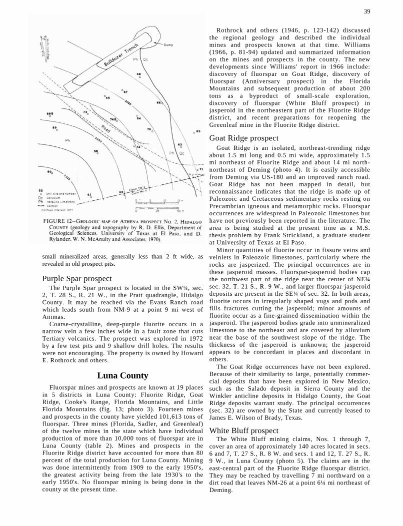
small mineralized areas, generally less than 2 ft wide, as revealed in old prospect pits.
Purple Spar prospect The Purple Spar prospect is located in the SW¼, sec.
2, T. 28 S., R. 21 W., in the Pratt quadrangle, Hidalgo County. It may be reached via the Evans Ranch road which leads south from NM-9 at a point 9 mi west of Animas.
Coarse-crystalline, deep-purple fluorite occurs in a narrow vein a few inches wide in a fault zone that cuts Tertiary volcanics. The prospect was explored in 1972 by a few test pits and 9 shallow drill holes. The results were not encouraging. The property is owned by Howard E. Rothrock and others.
Luna County Fluorspar mines and prospects are known at 19 places
in 5 districts in Luna County: Fluorite Ridge, Goat Ridge, Cooke's Range, Florida Mountains, and Little Florida Mountains (fig. 13; photo 3). Fourteen mines and prospects in the county have yielded 101,613 tons of fluorspar. Three mines (Florida, Sadler, and Greenleaf) of the twelve mines in the state which have individual production of more than 10,000 tons of fluorspar are in Luna County (table 2). Mines and prospects in the Fluorite Ridge district have accounted for more than 80 percent of the total production for Luna County. Mining was done intermittently from 1909 to the early 1950's, the greatest activity being from the late 1930's to the early 1950's. No fluorspar mining is being done in the county at the present time.
39
Rothrock and others (1946, p. 123-142) discussed the regional geology and described the individual mines and prospects known at that time. Williams (1966, p. 81-94) updated and summarized information on the mines and prospects in the county. The new developments since Williams' report in 1966 include: discovery of fluorspar on Goat Ridge, discovery of fluorspar (Anniversary prospect) in the Florida Mountains and subsequent production of about 200 tons as a byproduct of small-scale exploration, discovery of fluorspar (White Bluff prospect) in jasperoid in the northeastern part of the Fluorite Ridge district, and recent preparations for reopening the Greenleaf mine in the Fluorite Ridge district.
Goat Ridge prospect Goat Ridge is an isolated, northeast-trending ridge
about 1.5 mi long and 0.5 mi wide, approximately 1.5 mi northeast of Fluorite Ridge and about 14 mi north-northeast of Deming (photo 4). It is easily accessible from Deming via US-180 and an improved ranch road. Goat Ridge has not been mapped in detail, but reconnaissance indicates that the ridge is made up of Paleozoic and Cretaceous sedimentary rocks resting on Precambrian igneous and metamorphic rocks. Fluorspar occurrences are widespread in Paleozoic limestones but have not previously been reported in the literature. The area is being studied at the present time as a M.S. thesis problem by Frank Strickland, a graduate student at University of Texas at El Paso.
Minor quantities of fluorite occur in fissure veins and veinlets in Paleozoic limestones, particularly where the rocks are jasperized. The principal occurrences are in these jasperoid masses. Fluorspar-jasperoid bodies cap the northwest part of the ridge near the center of NE¼ sec. 32, T. 21 S., R. 9 W., and larger fluorspar-jasperoid deposits are present in the SE¼ of sec. 32. In both areas, fluorite occurs in irregularly shaped vugs and pods and fills fractures cutting the jasperoid; minor amounts of fluorite occur as a fine-grained dissemination within the jasperoid. The jasperoid bodies grade into unmineralized limestone to the northeast and are covered by alluvium near the base of the southwest slope of the ridge. The thickness of the jasperoid is unknown; the jasperoid appears to be concordant in places and discordant in others.
The Goat Ridge occurrences have not been explored. Because of their similarity to large, potentially commer-cial deposits that have been explored in New Mexico, such as the Salado deposit in Sierra County and the Winkler anticline deposits in Hidalgo County, the Goat Ridge deposits warrant study. The principal occurrences (sec. 32) are owned by the State and currently leased to James E. Wilson of Brady, Texas.
White Bluff prospect The White Bluff mining claims, Nos. 1 through 7,
cover an area of approximately 140 acres located in secs. 6 and 7, T. 27 S., R. 8 W. and secs. 1 and 12, T. 27 S., R. 9 W., in Luna County (photo 5). The claims are in the east-central part of the Fluorite Ridge fluorspar district. They may be reached by travelling 7 mi northward on a dirt road that leaves NM-26 at a point 6¼ mi northeast of Deming.


The White Bluff claims are owned by Barbara L. and Frances Leach of Deming but are leased to James E. Wilson of Brady, Texas.
GEOLOGY AND FLUORSPAR DEPOSITS—Rock units that crop out within the area covered by the White Bluff claims include: Precambrian granodiorite porphyry, Lake Valley Limestone (Mississippian), undifferentiated shale and conglomerate units (Pennsylvanian-Permian?), the Gila Conglomerate (Tertiary), and alluvium (Quaternary). A major northwest-trending fault forms a sharp boundary between the undifferentiated Pennsylvanian-Permian rocks and the Gila Conglom-erate. The Pennsylvanian-Permian rocks are strongly silicified (jasperized) in a swath 50 to 200 ft wide for a distance of several hundred feet adjacent to the fault. This jasperoid zone probably constitutes the principal source of fluorspar on the claims. Most, if not all, of several arroyos in the area are developed on faults. A linear, brecciated zone in the Lake Valley Limestone alongside one fault-controlled arroyo in the southwest corner of White Bluff No. 1 claim is strongly mineral-ized with fluorite.
The fluoritized zone of jasperoid adjacent to the northwest-trending fault, across White Bluff Nos. 1 and 4, merits exploration. It is similar to other fluorite-bearing jasperoid deposits in New Mexico which have been evaluated, and it may be a commercial deposit. Two samples collected from the jasperoid zone were analyzed and contained the following: Sample No. 1-49.0 percent CaF2 , 48.4 percent Sig, and 2.2 percent CaCO3; Sample No. 2-48.2 percent CaF2 , 43.4 percent Sig, and 4.0 percent CaCO3 . The brecciated zone in the
Lake Valley Limestone also deserves exploration. Samples from the Lake Valley Limestone contained: Sample No. 1-46.6 percent CaF2 , 41.2 percent Si02, and 4.8 percent CaCO3; Sample No. 2-54.6 percent CaF2 , 39.8 percent Si02, and 10.0 percent CaCO3 .
No mining and very little exploration work have been done on the White Bluff claims. A few shallow test pits, all less than 15 ft deep, have been dug at several places on the claims, but there has been no systematic program of geologic mapping and exploration.
Anniversary prospect The Anniversary prospect is located on the east side
of the Florida Mountains in SW1/4 sec. 1, T. 26 S., R. 8 W. The property consists of six claims, Anniversary 1-6, owned by Gene Cook of Deming, New Mexico. The claims were staked and filed in 1970. The property was leased and worked for a short time by Bailey Fluorspar Company of Marfa, Texas, which operated a fluorspar shipping terminal at Deming at that time. Bailey mined about 200 tons of 60 percent effective CaF2 .
The fluorspar occurs in silicified breccia along faults in Ordovician limestone (El Paso Formation) near the contact with underlying Precambrian granite. The fluo-rite occurs both as coarse-crystalline void fillings and as a sugary replacement of the limestone. In the area of the prospect a fluoritized silicified breccia or jasperoid zone forms the hanging(?) wall at the intersection of east- and northeast-trending faults. The breccia may have been formed by collapse into a sink; several small caves are exposed in the workings. Jasperoid breccias that appear to be related to faulting crop out at several places near the prospect. Fluorite occurs irregularly in the jasperoid masses. This area deserves further study and exploration.
Sierra County More than 30 small mines, prospects, and occurrences of
fluorspar are known in Sierra County (table 2 and fig. 14). Production has been recorded from 14 deposits, for an aggregate total of 33,855 tons. Most of the deposits are located in the Caballo Mountains (including the Derry Hills), but occurrences are known also in the San Andres, Salado, and Cuchillo Mountains. Fissure veins in Precambrian granite and Paleozoic limestones form

the dominant type; however, jasperoid deposits are numerous and probably contain the largest resources.
Several commercial or potentially commercial fluorspar deposits have been discovered in Sierra County during the past few years as the result of prospecting, exploration, and development work done by Ira Young, Win Industries, Midwest Oil Corpora-tion, Allied Chemical Corporation, and others. Studies by graduate students at University of Texas at El Paso and University of Western Ontario have contributed to the knowledge of fluorspar in Sierra County. Their theses covered portions of the following areas: southern Caballo Mountains (Martin A. Nelson); Cross Mountain-Chise area, Cuchillo Mountains (Edward J. Huskinson); and Salado Mountains (Albert L. Lamarre).
Deposits discovered since 1967 and previously known deposits and areas for which new information is available are discussed below.
Deposits in Caballo Mountains The present Caballo Mountains are the result of
Basin-and-Range faulting, eastward tilting, and regional uplift (Kelley and Silver, 1952). They are about
30 mi long (lat. 32° 41' to 33° 10' N.) and 6 to 11 mi wide, covering an area of approximately 165 sq mi. Elevations range from about 4,000 ft at the southern end to 7,330 ft in the central portion. Precambrian rocks (granite, gneiss, and schist), extensively exposed in the steep west-facing escarpment that parallels the Rio Grande valley, are overlain by about 5,000 ft of mostly marine rocks, sandstones, shales, limestones, and dolo-mites (map 12).
Most of the fluorspar deposits are exposed on an escarpment on the west side of the mountains. These deposits are in veins in Precambrian granite, and in veins and jasperoid bodies in Paleozoic limestones. However, both fissure-vein and jasperoid deposits are known at several places in Pennsylvanian and Permian limestones on the east (dip) slope. Limestones in the Magdalena Group host most of the deposits throughout the mountains.
Numerous fluorspar mines and prospects located in T. 14 and 15 S., R. 4 W., immediately south of Truth or Consequences and east of Caballo Reservoir in the northwestern part of the Caballo Mountains, have been mined and explored in the past to varying degrees. In fact, nearly 70 percent of the total production for Sierra

County came from the Cox, Governor, Illinois, and Independence properties in that area. However, there has been little or no production from any of the deposits in that area since about 1954; and, surprisingly, there has been no recent activity in that part of the Caballo Mountains district. These deposits have been described by Rothrock and others (1946) and Williams (1966).
Several deposits in the southern Caballo Mountains have been explored or partially explored and/or pros-pected in recent years, including the Lyda K, Nakaye, Alvarez, Red Star, Gar-Spar, and Lorraine.
Lyda K mine The Lyda K claims are located in secs. 19, 20, 21, 28, 29,
30, 31. 32, and 33, T. 16 S., R. 4 W. Forty-seven claims are included in the property, 7 of which are patented (fig. 15). The Lyda K mine is in sec. 29, about one mile southeast of Caballo Dam.
The New Mexico Fluorspar Company located the two original claims, Lyda K Nos. 1 and 2, prior to 1926. These claims were sold to Southwestern Fluorspar Corporation, and a mill was constructed on the property in 1927. One thousand tons of fluorspar were produced in 1928. A subsidiary of E. I. DuPont de Nemours bought the property in 1938 and shipped 457 tons of concentrate in that year. In 1943, 1,200 tons of ore were mined, and DuPont expanded the property to include 11 additional claims. Allied Chemical Corporation purchased the Lyda K from DuPont in the late 1950's. Allied began an extensive exploration program on the property in 1972 and located 34 new claims, bringing the total number of claims to 47. Allied's exploration and development included 15,000 ft of diamond coring, constructing of a new headframe on the No. 3 shaft, and bulk sampling.
The Lyda K workings consist of three vertical shafts, several drifts on different levels, and an adit. The No. 1 shaft, on the north side (hanging wall) of the Lyda K fault, was sunk to a depth of 126 ft; a 25-ft crosscut on the 106-ft level intersected the vein (photos 6, 7, and 8). Drifts were driven 185 ft northeast and 325 ft southwest along the hanging-wall side of the vein. Shaft No. 2, located 400 ft southwest of Shaft No. I, was sunk on the vein to a depth of 220 ft, and drifts were driven on the vein at the 71- and 220-ft levels. Two winzes about 15 ft apart connect the end of the northeast drift on the 71-ft level with the end of the southwest drift for Shaft No. 1. Shaft No. 3, located 1,500 ft southwest of Shaft No. 2, was sunk to a depth of 260 ft, and has drifts from it on the vein at levels of 60, 120, and 220 ft. This shaft is on the footwall side of the fault and is connected by
crosscuts to the vein on the different levels. The vein was stoped nearly to the surface along a 60-ft adit driven in the vein from a portal about 300 ft southwest of Shaft No. 2.
GEOLOGY AND FLUORSPAR DEPOSITS—The Lyda K mine and most of the claims are located in the Red Hills area on the west flank of the Caballo Mountains, a large window of Precambrian rocks composed of granite and minor gneiss and schist. The fluorspar occurs along the northeast-trending Lyda K fault, which can be traced across the outcrop of Precambrian rocks and into overlying Paleozoic sedimentary rocks (fig. 16). The Lyda K fault strikes N. 48° E. and dips variably from 70° to 85° NW. The Precambrian pink granite host rock

ranges from aphanitic to phaneritic in texture and is strongly foliated locally. The granite and granite gneiss contain inclusions of biotite schist. Small veins and stringers of milky quartz and numerous small pegmatite dikes are common in the area. The projection of the Lyda K fault is covered by Quaternary alluvium a short distance southwest of the Lyda K mine. The contact between the Quaternary alluvium and the Precambrian granite coincides with the approximate position of the northwest-trending Red Hills fault, and the Lyda K fault may be cut off by the Red Hills fault. The Precambrian rocks of the Red Hills are cut by several other faults (fig. 16).
Fluorspar occurs in jasperized fissure veins in the Lyda K fault zone. The fluorspar-bearing jasperoid vein material is more resistant to erosion than the granite host and stands dikelike above the granite. The vein ranges from 6 to 100 ft wide at the surface; it is 15 ft wide on the 220-ft level in the area of Shaft No. 2 and contains 50 to 60 percent CaF2. The fluorspar is fine to coarse crystalline, and much of it is purple and blue. The coarser crystalline fluorite generally occurs along the outer sides of the veins. Near Shaft No. 2 the vein material contains up to 5 percent galena, and it is estimated that twenty percent of the reserves in deposits along the Lyda K fault have an average of 1 percent lead. Assays of samples taken from various parts of the mine by the U.S. Geological Survey showed the following ranges in percentages of the chief constituents (Rothrock and others, 1946): CaF2, 46.2 to 82.7 percent; SiO2, 15.0 to 37.2 percent; and CaCO3 0.3 to 2.1 percent.
As the vein is essentially jasperoid, it is characterized by the chemical and tectonic brecciation typical of most jasperoid bodies. The fluorspar occurs in veins and veinlets within and alongside the jasperoid, and in vugs and fractures and as breccia cement within the jasperoid body. Allied Chemical Corporation has not released information on the results of the exploration program conducted on the Lyda K fault.
Nakaye deposits The Nakaye (Alamo) group of claims is located in the
NW1/4 sec. 22 and the SE¼ sec. 16, T. 17 S., R. 4 W., on the west side of Nakaye Mountain in the Caballo Mountains. Rothrock and others (1946) described part of this area under the heading of Alamo prospect. The group consists of 11 unpatented claims (fig. 17).
The area of the Nakaye mine in sec. 22 was claimed in 1918 and originally included 7 claims. Alamo No. 1, in sec. 15, was located in 1941 by C. B. Hanson; 300 tons of ore were shipped from this claim during World War II (Williams, 1966, p. 112). Three additional claims (Alamo Nos. 1-3) were located in 1949 in sec. 27 by Blanchard Hanson and B. A. Luchini. In 1944 Alamo Nos. 4 and 5 were staked. Hanson sold his interest to B. A. Luchini; B. W. Luchini of Las Cruces, New Mexico, is the present owner. The total production from the Nakaye group of claims is 5,471 tons through 1952, and there has been no production recorded since that time (Williams, 1966, p. 112). Workings on the Nakaye group of claims consist of two open cuts along the Nakaye fault, five adits, three inaccessible shafts, and numerous pits (fig. 18).
GEOLOGY AND FLUORSPAR DEPOSITS—The Nakaye claims are located on a horst in which the Red House and Nakaye Formations of the Magdalena Group (Pennsylvanian) are exposed. It is the type locality for the Nakaye Formation. The Red House Formation makes up approximately the lower third of the Mag-dalena Group. It consists chiefly of shale, with in-tercalated thin-bedded and nodular, medium-gray limestone. At the type section, along South Ridge in the southern Caballo Mountains, it is 362 ft thick.
The Nakaye Formation rests conformably on the Red House Formation throughout the Caballo Mountains. It is composed of massive, medium-gray limestone sepa-rated by thin beds of shale. In places it contains thin-bedded and nodular, dark-brown to black chert.
The Nakaye Mountain horst block is cut by the east-west Nakaye fault and other parallel faults and fractures in the vicinity of the Nakaye claims (fig. 18).

Sizable bodies of jasperoid, both discordant and con-cordant, occur in the Nakaye Formation in this area.
Fluorspar deposits are present in both the Red House and Nakaye Formations (photos 9, 10, and 11), but the larger deposits appear to be in the Red House Forma-tion. Those in the Red House Formation are principally concordant bedded replacements of limestone and
shale. They pinch and swell, ranging from nearly zero to 5 ft in thickness. A topographic bench at the north-end of the claims appears to be underlain by stratiform fluorspar deposits under cover of 2 to 10 ft of limestone. Stratiform replacement fluorspar occurs in at least three stratigraphic intervals.
Fluorspar deposits also occur in jasperoid veins and pods along faults on the Nakaye claims. Several faults in the area appear to have served as feeders to the stratiform replacement deposits. The fluorite in the Nakaye deposits ranges in texture from sugary to

coarsely crystalline, and colors include pale green, dark blue, pale brown, and white.
Proved reserves on the Nakaye claims probably are no more than a few hundred tons; probable reserves, estimated from surface exposures and mine workings, are about 10,000 tons of 35 percent CaF 2 . No systematic exploration has been done on the Nakaye property,
although the environment is favorable for large high-grade replacement deposits.
Alvarez prospects The Alvarez claims are located on the north side of
Green Canyon in secs. 3, 4, 9, 10, and 15, T. 17 S., R. 4 W., on the southeast flank of the Red Hills in the Caballo Mountains. The group includes 25 unpatented claims owned by Juan Alvarez of Las Cruces and 4 adjoining unpatented claims reportedly owned by Roy Fuller of Truth or Consequences, New Mexico.
A few shallow test pits were dug on some of these claims several years ago, but no production is recorded. Allied Chemical Corporation explored the west end of the property in 1970-71 by means of a 126-ft drift and five core holes. Allied dropped their option, and no work has been done on the claims recently.
GEOLOGY AND FLUORSPAR DEPOSITS—The Alvarez claims are on the Nakaye Formation, which dips southeastward off the Precambrian granite core of the Red Hills (map 12). Several northwest- and northeast-trending faults cut Nakaye limestones in the area. At the northwest end of the property an en echelon northeast-trending fault zone is irregularly filled with jasperoid and fluorite. It was this area that was explored by Allied Chemical Corporation. A block of stratiform fluorspar-bearing jasperoid forms the dip slope on a small hill at the east end of the property (fig. 19).

Fluorite is present in the jasperoid body in pods, veinlets, and vug fillings. The jasperoid is cut by northwest-trending sheeted zones, within which fluorspar is abundant. The outcropping portion of the jasperoid mass is 500 ft long and 200 ft wide; it passes under alluvium downdip. The thickness of the body is unknown.
Samples taken from the Allied Chemical Corporation adit contained 2.2 to 48.0 percent CaF2. A grab sample taken from a trench above the adit by Nelson (1974) contained 23.76 percent CaF2, 60.4 percent SiO2 and 1.25 percent CaCO3. Proved reserves on the Alvarez claims are only a few hundred tons; relatively little exploration work would demonstrate probable reserves of 30,000 tons, and the inferred reserves (20 percent Ca F2) are about 150,000 tons.
Red Star prospects Twenty unpatented claims known as the Red Star
group are located in secs. 20, 21, 28, 29, and 33, T. 19 S., R. 4 W., east of 1-25 in the Derry Hills (fig. 20). This group includes the two Esperanza claims discussed by Johnston (1928). The Red Star group is owned by John Hanson and Gerald Aday of Truth or Consequences, New Mexico.
A few shallow test pits and short adits were excavated many years ago, but no production was ever recorded. The Esperanza claims were allowed to lapse, and the Red Star group was staked in 1973.
Workings on the Red Star claims consist of a series of 9 bulldozer cuts stepped one above the other on the north slope of the Derry Hills, several short adits and shallow test pits, and some percussion drilling. The adits and pits predate the present ownership. The lowest bulldozer cut is in colluvium; the second, fourth, sixth, and seventh cuts expose 6-inch to 2-ft veins of green
47
coarse-crystalline fluorite. The eighth cut, near the old Esperanza workings, exposes a vein of fluorite ranging from '/8 inch to 1.5 ft in width. About ½ mi southwest of the bulldozer cuts are four 5- to 15-ft adits cut in a breccia zone along a north-trending fault.
GEOLOGY AND FLUORSPAR DEPOSITS—Alluvium covers the northern and eastern portions of the claims. Mon-toya Group (Ordovician) limestones are exposed in a southeast-plunging anticline and a syncline in the northeastern part of the area. The Aleman Formation (Ordovician) crops out on the flanks of the anticline. Faults trending N. 30° W. generally parallel to the fold axis cut the limestones. The Montoya is faulted against an overturned section of upper Magdalena limestone and Abo Formation (Pennsylvanian and Permian, re-spectively) in the southwestern part of the area. Fluorspar-bearing jasperoid bodies occur in limestones of both the Montoya and Magdalena Groups.
Fluorspar deposits on the Red Star claims occur in the Ordovician Montoya Group and Pennsylvanian Magdalena Group—chiefly in fissure veins, but prob-ably most of the minable reserves are associated with irregular-shaped jasperoid bodies. Intense folding of strata in the Derry Hills produced extensive brecciation along bedding-plane faults and ground preparation favorable for replacement deposits. Fluorite is present in coarsely crystalline pods and veins and as fine-grained veinlets in the jasperoid bodies; the jasperized zones are cut by irregular veins, veinlets, and local stockworks. The principal fluorspar-bearing jasperoid mass is about 800 ft long and 300 ft wide, trending subparallel to the northwest-trending anticlinal fold axis. Several large bodies of jasperoid crop out along the main Derry Hills fault, which juxtaposes the Mon-toya and Magdalena limestones.
No proved reserves are known on the Red Star claims; probable reserves are of the order of 5,000 tons. However, the fluorspar-bearing jasperoid masses in the area may contain very large low-grade resources, particularly if some of the masses are keel-shaped.
Gar-Spar deposits The Gar-Spar Group of 9 unpatented claims is
located in the northwestern part of sec. 31, T. 17 S., R. 3 W. (fig. 21). No production has been recorded from any of the claims in Gar-Spar Group. This group probably includes the old Velarde claims mentioned in earlier literature (Rothrock and others, 1946); old workings match descriptions of workings on the Velarde claims. However, the location given for the Velarde claims puts them in SW¼ sec. 33, T. 17 S., R. 3 W. and NW¼ sec. 4, T. 18 S., R. 3 W. The workings, two trenches and several pits, apparently were dug a long time ago. The present Gar-Spar claims were staked in 1972 by Quentin Drunzer and Joe Amin of Truth or Consequences, New Mexico.
GEOLOGY AND FLUORSPAR DESPOSITS—The Gar-Spar claims are laid two abreast in a northwest-southeast direction astride an en echelon fault zone up to 350 ft wide striking northwest, generally parallel to the strike of strata in the area. The claims are on the southwest flank of Flat Top Mountain, a southeast-plunging anticlinal fold (map 12). Faulting juxtaposes strata of the Bar B Formation (Upper Pensylvanian) and Abo

Formation (Permian) and/or those of the Nakaye and Bar B Formations in the area of the claims. The strata strike northwest and dip 20° to 60° southwest. Most of the en echelon faults appear to have a stratigraphic throw of less than 50 ft. The northwest-trending fault zone may radiate from the Salem plug, a small intrusion of quartz latite located in NE¼ sec. 5, T. 18 S., R. 3 W.
A swath of fluorspar-bearing jasperoid is present in the southeast portion of the fault zone. Most of the jasperoid and associated fluorite occurs as selective replacement of Nakaye limestone along the contact between the Nakaye Formation and overlying Bar B Formation. Fluorite occurs in coarsely crystalline pods, veinlets, and as fracture coatings within the jasperoid. The jasperoid is cut by fractures oblique to the main trend of the fault zone, and these fractures appear to have localized fluorite. The jasperoid masses range in outcrop thickness from 5 to 15 ft. Fluorite is most abundant in a zone 3 to 5 ft below the top of the jasperoid. Downdip exposures of the jasperoid range in width from 60 to 200 ft, depending on the dip of the strata. Approximately 2,000 ft of strike length is present along the best zone of fluorite. It is estimated that the average fluorite content of the jasperoid is 20 percent; local pods grade up to 35 percent CaF2. Fluorite also occurs in at least one fissure vein 6 to 8 ft wide in the fault zone. This vein contains coarsely crystalline green fluorite, and has a CaF2 content of 40 to 50 percent.
No proved reserves can be assigned to the Gar-Spar prospect at the present time; probable reserves can be placed at 15,000 to 20,000 tons containing 25+ percent CaF2. However, this interesting jasperoid deposit could easily contain 100,000 to 150,000 tons of 20 to 25 percent CaF2, and additional resources are possible in other jasperoid bodies elsewhere on the claims.
Lorraine deposits The Lorraine Group of 6 unpatented claims is located in
the S1/2 of sec. 3 and the NE¼ of sec. 10, T. 17 S., R. 4 W. (fig. 22).
The, Lorraine claims were located by C. R. Buckelew in 1948, five for fluorspar and one for manganese. The claims are owned presently by Opal and Larry Buckelew of Hatch, New Mexico. A small tonnage of fluorspar produced by assessment work has been shipped. Workings consist of a 40-ft adit, another shorter adit, and several trenches and shallow test pits.
GEOLOGY AND FLUORSPAR DEPOSITS—The Lorraine claims are located in a highly faulted area on Montoya Group (Ordovician) and Magdalena Group (Pennsylva-nian) formations in the southern part of the Red Hills (map 12). Much of the area is covered by colluvium, and bedrock outcrops are scarce. The area is cut by several subparallel faults that strike generally west and dip about 80 degrees north. Jasperoid is present along the fault zone. Fluorspar occurs in Montoya Group limestones in both fissure veins and fluorspar-bearing jasperoid mantos. The 40-ft adit cuts a fault zone and exposes a vein 5 ft wide containing coarsely crystalline green and white sugary fluorite, and calcite gangue. This zone can be traced approximately 600 ft westward from the adit. The westernmost working, a trench and an adit directed N. 65° W. along the fault, exposes a brecciated zone about 8 ft wide. A vein 1.5 ft wide consisting of green and purple coarsely crystalline fluorite is exposed in the adit. No proved reserves can be assigned to this prospect, but the area has not been adequately explored. There are several outcrops of fluorspar, and the area warrants additional prospecting.
Carroll prospect In 1971 fluorspar was found at several places in sec. 1,
T. 15 S., R. 4 W. by Coy Carroll, Williamsburg, New Mexico. Eighteen claims were located in the area by Carroll, Abe Rouse of Winston, and Dave Fields of Deming. A small amount of excavating was done at one site, but there has been no systematic exploration. These claims are located about 30 mi southeast of Truth or Consequences.
GEOLOGY AND FLUORSPAR DEPOSITS—Widespread fluoritization associated with both discordant and con-cordant jasperization occurs in limestones of the Mag-

dalena Group (Pennsylvanian). Outcrops of fluorite and fluorite-bearing jasperoid are scattered over the rela-tively steep dip slope on the east side of the Caballo Mountains at elevations ranging from about 5,500 ft to 6,500 ft.
Coarse-grained fluorite fills vugs and openings be-tween breccia clasts of jasperoid. The fluorite is distrib-uted very irregularly throughout the jasperoid, with the CaF2 content ranging from less than 5 percent to more than 60 percent. The average CaF2 content is unknown, but based on information about similar deposits elsewhere in New Mexico, it is estimated to be between 20 percent and 35 percent. Bulk sampling will have to be done to establish a reliable average grade. The deposits in the outcrops appear to be concordant (mantos) with an average thickness of 5 to 6 ft; as exposed, the thicknesses appear to range from less than 2 ft to more than 15 ft. Discordant feeder zones are exposed in a few places. The fluorite jasperoid deposits crop out in the floors and walls of deep arroyos and on steep slopes.
Two well-developed mantos are present at different horizons over an extensive area, and abundant float elsewhere indicates the existence of others, possibly at several other horizons. One of the large mantos crops out along an arroyo for about 1,500 ft and has an exposed width of 100 ft and a thickness of 6 to 8 ft. The other manto can be traced in ledges on a slope for about 3,000 ft. These mantos may extend back under cover a few tens of feet; if so, there could be several million tons of fluoritized jasperoid in the area minable by open-cast methods.
Salado district The Salado district is located in T. 13 and 14 S., R. 6
and 7 W., in west-central Sierra County, about 15 air mi southwest of Truth or Consequences on the Esquipula T. Chavez Ranch.
Milton Head and Allen Sphar of Grants, New Mexico, discovered fluorite in the Salado Mountains in the spring of 1972. The property (84 unpatented claims) was optioned to Midwest Oil Corporation in 1973; under the direction of Perry, Knox, and Kauf-man, Consultants, and Midwest Oil Corporation geol-ogists, a portion of the property was explored by 47 rotary percussion drill holes, one diamond core drill hole, and numerous excavations. Midwest Oil Corporation was absorbed by Amoco (Standard Oil Company of Indiana) in 1974, and Amoco dropped the lease. The DuPont Company currently holds an option on the property.
GEOLOGY—The Salado Mountains form the middle segment of a generally north-trending range that extends from the vicinity of Lake Valley on the south to the northern end of the Sierra Cuchillo to the north, a distance of about 50 mi. The trend parallels the east front of the Black Range. The Salado segment is an upfaulted block composed of Precambrian granite, metadiorite, and muscovite schist overlain by sedimen-tary rocks of Paleozoic age and volcanic rocks of Tertiary age (map 13). Intrusive rocks in the area include monzonite-nepheline monzodiorite and andes-ite (Lamarre, 1974). The area was uplifted and faulted
49
by Basin-and-Range tectonism. The stratigraphic section is given in table 5.
The larger concentrations of fluorite known in the Salado district are in the Red House and Nakaye Formations of the Magdalena Group, although small amounts occur in older Paleozoic formations and in intrusive igneous rocks of Tertiary age.
The Red House Formation, the lowermost formation of the Magdalena Group, is composed of thin- to thick-bedded, fine-grained, fossiliferous limestone (biomicrite). Layers of calcareous shale and mudstone and laminated dark-gray limestone are interbedded with biomicrite. From 4 to 10 ft of crossbedded sandstone is present in the upper part of the formation. The formation contains an appreciable amount of chert in the form of intergrowths, pods, and beds. The Red House Formation is approximately 367 ft thick in the Salado Mountains.
The Nakaye Formation conformably overlies the Red House Formation. The Nakaye Formation is made up of thin- to medium-bedded limestone, and it can be distinguished from the Red House Formation by its lack of shale units and lower chert content. Prominent ledges and cliffs are developed on the Nakaye Formation in the Salado district; ledges and cliffs along the Fox Canyon-Long Canyon fault scarp of Nakaye limestones form the crest of the Salado Mountains. The dip slopes, on the east and northeast sides of the mountains, are developed on the Nakaye. The formation is approximately 310 ft thick in the Salado district.
Both Laramide and Basin-and-Range tectonism left imprints on the Salado district. Laramide structure includes doming, folding, and east-trending faulting. Basin-and-Range tectonism produced north-trending and northeast-trending normal faults, joints, breccia zones, and eastward tilting.
Most of the known potentially commercial fluorspar deposits in the Salado Mountains are in jasperoid bodies. Jasperization is widespread in the district, and all formations except those of Precambrian, Cambrian-Ordovician, Devonian, and Permian ages contain fluorite-bearing jasperoid bodies in one place or another.
FLUORSPAR DEPOSITS—The largest known fluorspar-jasperoid deposits are in the Red House and Nakaye Formations. Such a deposit in the Red House Forma-tion at South Hill appears to be a commercial deposit.
The following types of deposits occur in the Salado district:
1) Fluorite jasperoid deposits a) as matrix material in fault breccia b) as replacement of quartz, coating breccia
fragments c) as fillings in hairline fractures cutting breccia
fragments d) as crystals lining vugs in brecciated jasperoid e) as coontail layering—alternating thin layers of
fluorite and jasperoid f) as fissure veins and veinlets of quartz and fluorite
cutting jasperoid 2) Fissure vein (void-filling) deposits in limestone and
Tertiary andesite 3) Pods of fluorite in the contact aureole around

an intrusion of monzonite and nepheline mon-zodiorite
Lamarre (1974) described the fluorite in the Salado Mountains as follows:
Typical fluorite of the Salado Mountains is medium- to coarsely-crystalline and subhedral with cubic habit, although octahedral fluorite is occasionally found. Fresh fluorite is colorless, light-green, white or purple in color; on exposure to sunlight it turns white. Weathered surfaces are light brown in color and look very much like calcite. Pyrite is disseminated in trace amounts in fluorite and the fluorite is both fluorescent and radiogenic.
South Hill deposit The South Hill fluorite jasperoid deposit was inten-
sively explored and evaluated by Midwest Oil Corpora-tion in 1973. The exploration included drilling of 47 rotary percussion holes, 1 diamond drill hole, and excavation of several trenches and shallow shafts. Based on information obtained from that work and detailed geologic mapping of the area, Lamarre (1974) described the deposit as follows:
The Salado (South Hill) fluorite deposit is an open-space filling of fluorite in a strata-bound breccia in jasperoid and mudstone within the Red House Forma-

tion of Pennsylvanian age. In plan, the deposit is 400 to nearly 600 feet wide by 1,400 feet long with the long axis striking N. 20° E. The average thickness is 42 feet and the thickest section is 150 feet at an elevation of 6,000 feet on South Hill. Probable ore reserves calcu-lated from drill hole data are 2.35 million tons averag-ing 19.35 percent CaF 2 with a cut-off grade of 15 percent CaF2 over 5 feet.
The tabular- to keel-shaped fluorite-jasperoid deposit in South Hill is cut by five subparallel faults which strike N. 20° E. and dip 62° to 82° southeast; the strikes are subparallel to the axis of a gentle anticline. Most of the orebody lies between the two outer bounding faults. Although brecciation is strong throughout the jasperized mass, it is most intense along and near the faults. Fluorite is largely concentrated in brecciated zones where it forms the cement or matrix. The fluorite content varies greatly from one place to another. A plan map, two cross sections, and distribution of the fluorite are shown in figures 23, 24, 25, and 26. Spectrographic analyses are given in table 6.
Numerous jasperoid bodies and several fissure veins known in the district have not been explored, and chances are good that additional exploration in the district will discover at least as much fluorspar as was found in the South Hill deposit. By using 10 percent CaF2 as the cut-off ore grade, the reserves in the South
Hill deposit would increase from 2.35 million tons averaging 19.35 percent CaF2 to 3.27 million tons of 17.6 percent CaF2.
Metallurgical studies on the South Hill ore show that a concentrate suitable for pelletizing and salable for metallurgical uses can be made. Recent metallurgical testing by the DuPont Company proved that an acid-grade concentrate can be made from the ore.
Chise (Cross Mountain) district The Chise or Cross Mountain fluorspar district is
located in the northwestern part of T. 12 S., R. 7 W., about two miles east of Chise, in the southwestern part of Sierra Cuchillo, Sierra County. The district is 49 mi northwest of Truth or Consequences, using US-85 and NM-52. The Victorio prospect, original discovery in the district, is in sec. 16, T. 12 S., R. 7 W.
The Victorio prospect was explored some time prior to 1943 by several shallow trenches and a shaft about 40 ft deep. There is no record of any production. The Victorio prospect is on a State-owned section, and Ira Young of Deming, New Mexico, acquired the section and adjoining land in the late 1960's. Young performed an appreciable amount of trenching, bulldozing, benching, and drilling. Win Industries leased the properties from Young in 1970 and began small-scale mining from opencuts on Cross Mountain, chiefly at the site of the old Victorio prospect. A few hundred tons of low-grade, siliceous ore was mined. In 1972 Win Industries com-
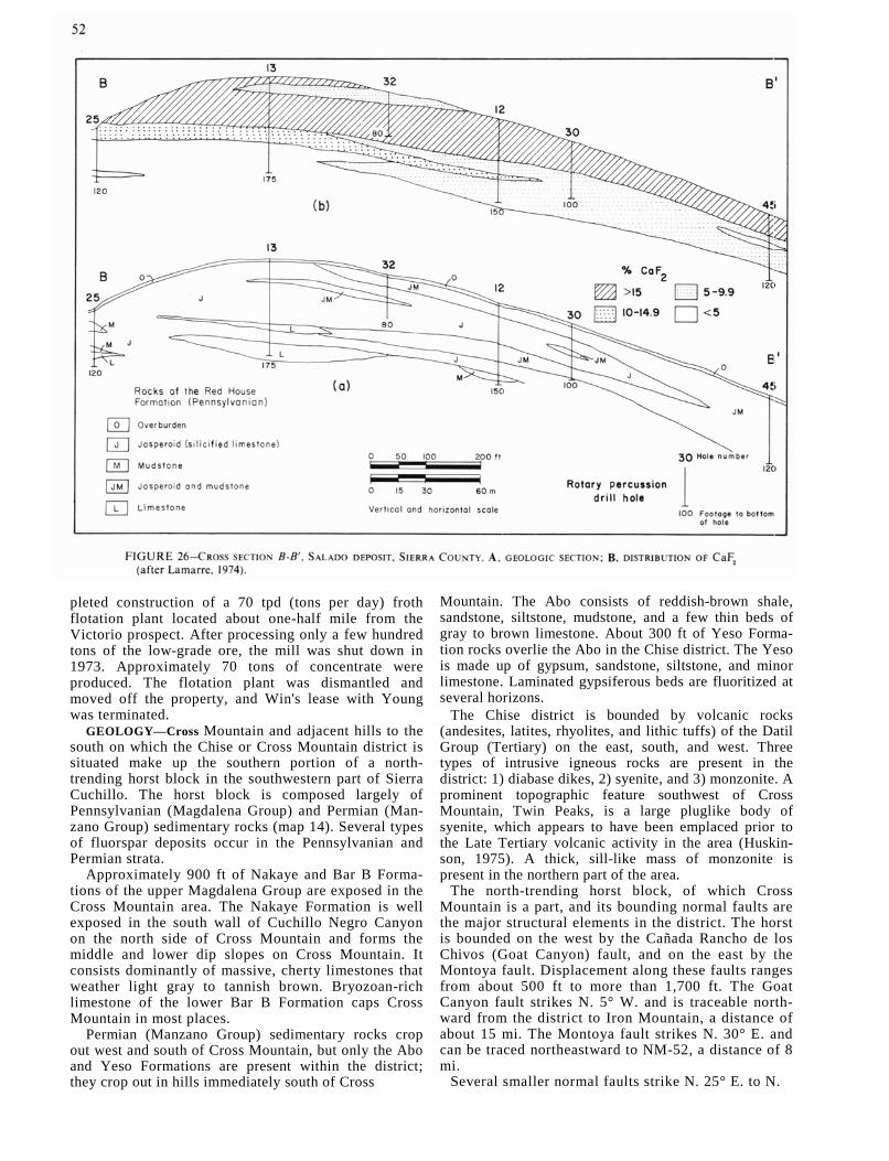
pleted construction of a 70 tpd (tons per day) froth flotation plant located about one-half mile from the Victorio prospect. After processing only a few hundred tons of the low-grade ore, the mill was shut down in 1973. Approximately 70 tons of concentrate were produced. The flotation plant was dismantled and moved off the property, and Win's lease with Young was terminated.
GEOLOGY—Cross Mountain and adjacent hills to the south on which the Chise or Cross Mountain district is situated make up the southern portion of a north-trending horst block in the southwestern part of Sierra Cuchillo. The horst block is composed largely of Pennsylvanian (Magdalena Group) and Permian (Man-zano Group) sedimentary rocks (map 14). Several types of fluorspar deposits occur in the Pennsylvanian and Permian strata.
Approximately 900 ft of Nakaye and Bar B Forma-tions of the upper Magdalena Group are exposed in the Cross Mountain area. The Nakaye Formation is well exposed in the south wall of Cuchillo Negro Canyon on the north side of Cross Mountain and forms the middle and lower dip slopes on Cross Mountain. It consists dominantly of massive, cherty limestones that weather light gray to tannish brown. Bryozoan-rich limestone of the lower Bar B Formation caps Cross Mountain in most places.
Permian (Manzano Group) sedimentary rocks crop out west and south of Cross Mountain, but only the Abo and Yeso Formations are present within the district; they crop out in hills immediately south of Cross
Mountain. The Abo consists of reddish-brown shale, sandstone, siltstone, mudstone, and a few thin beds of gray to brown limestone. About 300 ft of Yeso Forma-tion rocks overlie the Abo in the Chise district. The Yeso is made up of gypsum, sandstone, siltstone, and minor limestone. Laminated gypsiferous beds are fluoritized at several horizons.
The Chise district is bounded by volcanic rocks (andesites, latites, rhyolites, and lithic tuffs) of the Datil Group (Tertiary) on the east, south, and west. Three types of intrusive igneous rocks are present in the district: 1) diabase dikes, 2) syenite, and 3) monzonite. A prominent topographic feature southwest of Cross Mountain, Twin Peaks, is a large pluglike body of syenite, which appears to have been emplaced prior to the Late Tertiary volcanic activity in the area (Huskin-son, 1975). A thick, sill-like mass of monzonite is present in the northern part of the area.
The north-trending horst block, of which Cross Mountain is a part, and its bounding normal faults are the major structural elements in the district. The horst is bounded on the west by the Cañada Rancho de los Chivos (Goat Canyon) fault, and on the east by the Montoya fault. Displacement along these faults ranges from about 500 ft to more than 1,700 ft. The Goat Canyon fault strikes N. 5° W. and is traceable north-ward from the district to Iron Mountain, a distance of about 15 mi. The Montoya fault strikes N. 30° E. and can be traced northeastward to NM-52, a distance of 8 mi.
Several smaller normal faults strike N. 25° E. to N.
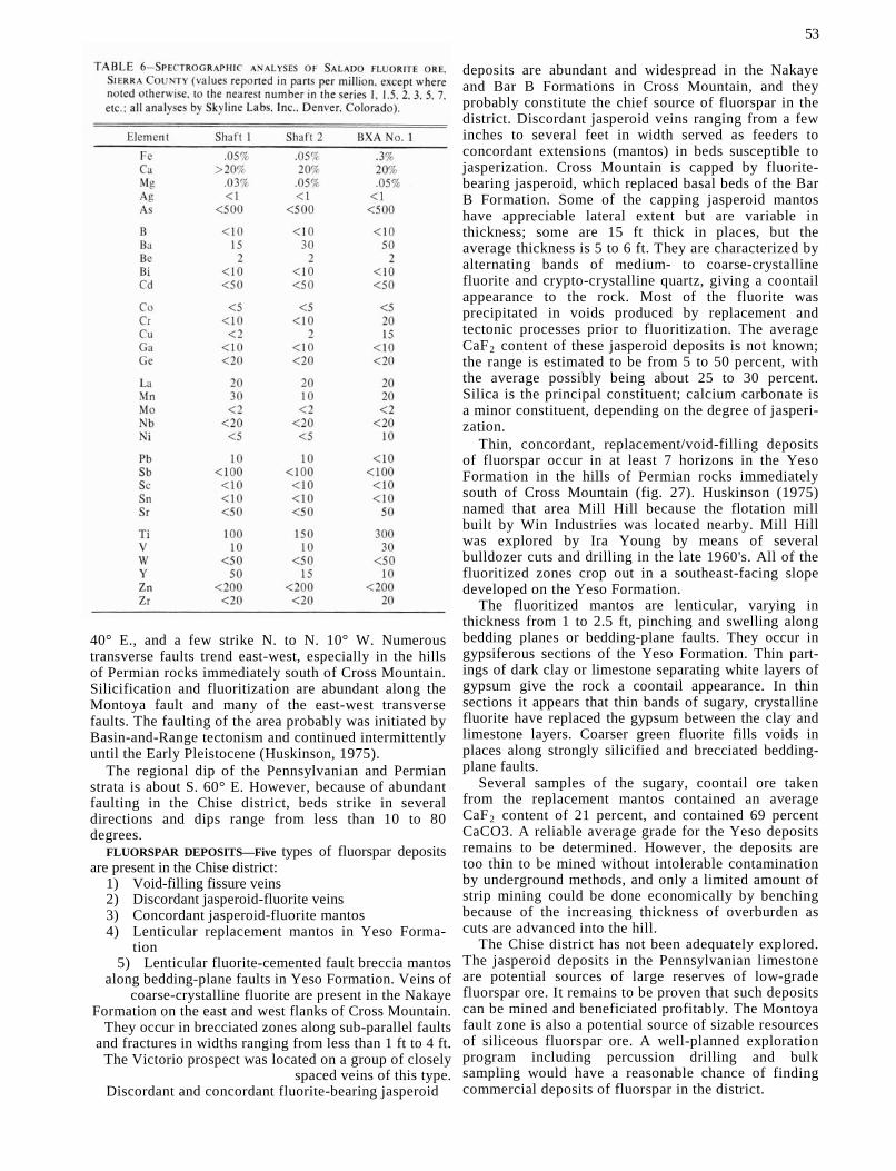
40° E., and a few strike N. to N. 10° W. Numerous transverse faults trend east-west, especially in the hills of Permian rocks immediately south of Cross Mountain. Silicification and fluoritization are abundant along the Montoya fault and many of the east-west transverse faults. The faulting of the area probably was initiated by Basin-and-Range tectonism and continued intermittently until the Early Pleistocene (Huskinson, 1975).
The regional dip of the Pennsylvanian and Permian strata is about S. 60° E. However, because of abundant faulting in the Chise district, beds strike in several directions and dips range from less than 10 to 80 degrees.
FLUORSPAR DEPOSITS—Five types of fluorspar deposits are present in the Chise district:
1) Void-filling fissure veins 2) Discordant jasperoid-fluorite veins 3) Concordant jasperoid-fluorite mantos 4) Lenticular replacement mantos in Yeso Forma-
tion 5) Lenticular fluorite-cemented fault breccia mantos
along bedding-plane faults in Yeso Formation. Veins of coarse-crystalline fluorite are present in the Nakaye
Formation on the east and west flanks of Cross Mountain. They occur in brecciated zones along sub-parallel faults
and fractures in widths ranging from less than 1 ft to 4 ft. The Victorio prospect was located on a group of closely
spaced veins of this type. Discordant and concordant fluorite-bearing jasperoid
53
deposits are abundant and widespread in the Nakaye and Bar B Formations in Cross Mountain, and they probably constitute the chief source of fluorspar in the district. Discordant jasperoid veins ranging from a few inches to several feet in width served as feeders to concordant extensions (mantos) in beds susceptible to jasperization. Cross Mountain is capped by fluorite-bearing jasperoid, which replaced basal beds of the Bar B Formation. Some of the capping jasperoid mantos have appreciable lateral extent but are variable in thickness; some are 15 ft thick in places, but the average thickness is 5 to 6 ft. They are characterized by alternating bands of medium- to coarse-crystalline fluorite and crypto-crystalline quartz, giving a coontail appearance to the rock. Most of the fluorite was precipitated in voids produced by replacement and tectonic processes prior to fluoritization. The average CaF2 content of these jasperoid deposits is not known; the range is estimated to be from 5 to 50 percent, with the average possibly being about 25 to 30 percent. Silica is the principal constituent; calcium carbonate is a minor constituent, depending on the degree of jasperi-zation.
Thin, concordant, replacement/void-filling deposits of fluorspar occur in at least 7 horizons in the Yeso Formation in the hills of Permian rocks immediately south of Cross Mountain (fig. 27). Huskinson (1975) named that area Mill Hill because the flotation mill built by Win Industries was located nearby. Mill Hill was explored by Ira Young by means of several bulldozer cuts and drilling in the late 1960's. All of the fluoritized zones crop out in a southeast-facing slope developed on the Yeso Formation.
The fluoritized mantos are lenticular, varying in thickness from 1 to 2.5 ft, pinching and swelling along bedding planes or bedding-plane faults. They occur in gypsiferous sections of the Yeso Formation. Thin part-ings of dark clay or limestone separating white layers of gypsum give the rock a coontail appearance. In thin sections it appears that thin bands of sugary, crystalline fluorite have replaced the gypsum between the clay and limestone layers. Coarser green fluorite fills voids in places along strongly silicified and brecciated bedding-plane faults.
Several samples of the sugary, coontail ore taken from the replacement mantos contained an average CaF2 content of 21 percent, and contained 69 percent CaCO3. A reliable average grade for the Yeso deposits remains to be determined. However, the deposits are too thin to be mined without intolerable contamination by underground methods, and only a limited amount of strip mining could be done economically by benching because of the increasing thickness of overburden as cuts are advanced into the hill.
The Chise district has not been adequately explored. The jasperoid deposits in the Pennsylvanian limestone are potential sources of large reserves of low-grade fluorspar ore. It remains to be proven that such deposits can be mined and beneficiated profitably. The Montoya fault zone is also a potential source of sizable resources of siliceous fluorspar ore. A well-planned exploration program including percussion drilling and bulk sampling would have a reasonable chance of finding commercial deposits of fluorspar in the district.

Valencia County Zuni Mountains deposits
Mines and prospects in the Zuni Mountains in northwestern Valencia County have yielded approxi-mately 224,000 tons of crude fluorspar ore (182,033 tons of marketed product), making Valencia County second only to Grant County in the production of fluorspar in New Mexico.
Fluorspar was discovered in the Zuni Mountains in 1908, but not until 1937 was the first fluorspar shipped from the district. The most productive period was between 1943 and 1953 when the Shattuck Denn Corporation operated a flotation plant at Los Lunas.
The district has been inactive since the Los Lunas plant was closed in 1953.
The geology and fluorspar deposits of the Zuni Mountains have been described by several workers, including Goddard (1945, 1952, 1966), Rothrock and others (1946), and Williams (1966). A geologic map and sections of the Zuni Mountains fluorspar district, prepared by E. N. Goddard, was published by the U.S. Geological Survey in 1966. The information given below has been taken from earlier work by Rothrock and others and Goddard.
GEOLOGY—The Zuni Mountains are developed over a elongated dome of Precambrian rocks surrounded or the flanks by Permian sedimentary rocks. The area of

Precambrian rocks is partly bounded by faults. The Precambrian rocks consist of a complex of granitic and metamorphic rocks. The most widespread rock is a gneissic granite which apparently is part of a batholith. Outcrops of porphyritic aplite and aplitic granite are also extensive. Stocks and dikes of porphyritic aplite intrude the gneissic granite but are gradational with it locally. The gneissic granite is also intruded by irregular masses and dikes of gneissic aplite. Well-foliated metarhyolite crops out over an extensive area in the northwestern part of the mountains. The metarhyolite is altered to quartz sericite schist in shear zones. Other intrusive igneous rocks of Precambrian age in the area include small stocklike bodies and dikes of biotite granite in the northern part of the area; small bodies of syenite, probably related to the biotite granite; diorite and monzonite dikes; and small, irregular dikes and small bodies of hornblende, granite, gabbro, and intrusive basalt, locally bordered by hornblende granite. Metamorphic rocks in the Zuni Mountains include fine-grained to medium-grained quartzite, dark-green hornblende gneiss, biotite schist, and quartz-biotite injection gneiss (Goddard, 1966).
Structures in the Zuni Mountains include east to northeast foliation of the metamorphic rocks, strong northwest-trending faults, and younger east-northeast faults that cut the more prominent northwest-trending system. The east- to northeast-trending foliation of the metamorphic rocks probably indicates the regional structural trend. The prominent northwest system of steeply-dipping faults cuts the Permian rocks and is probably Laramide. Most of the fluorspar-bearing veins dip steeply to the southeast or south.
The northwest-trending faults are commonly bor-dered by alteration zones up to 1,000 ft wide in which the granite or aplite is mildly silicified and colored red
55
by finely disseminated hematite. Such alteration zones are common in the southeastern part of the district (Goddard, 1966).
FLUORSPAR DEPOSITS—The principal fluorspar mines and prospects in the Zuni Mountains district are listed in table 2. Most of the known deposits are concentrated in three separate areas: 1) in the extreme southeast part of the mountains, around the 21 and 27 mines, 2) in an area about 6 mi northwest of the 21 and 27 mines, and 3) in the extreme northern part of the mountains, around the Mirabal mines. Several scattered ocurrences are known outside the three principal areas (fig. 28).
The fluorspar occurs as open-space filling (minor replacement) in fissure veins ranging from a few inches to more than 15 ft in width. Generally the fluorite is coarse crystalline and green, but in brecciated zones containing broken wallrock the breccia is cemented with fine-grained purple fluorite. The depths to which min-able fluorspar-bearing veins extend are unknown. The largest mines in the district, the 21 and 27, were mined to depths of 700 and 380 ft respectively, and each bottomed in strong veins of fluorspar. Most of the mines and prospects in the district are less than 100 ft deep. Impurities in the vein material include calcite (abundant locally), fine-grained quartz (locally), wallrock, trace amounts of barite in some veins, and (rarely) lead, zinc, and copper sulfides. Sulfide minerals are generally sparse or absent. The grade of the fluorspar varies, depending on the amount of wallrock included. Ore mined selectively from the veins ranged from 85 to 93 percent CaF2; ore shipped to the Los Lunas flotation plant ranged from 17 to 81 percent CaF2. By blending of ores at the plant, the average mill feed was about 40 percent CaF2.
Most of the fluorspar-bearing veins are developed

56
along east-trending and northeast-trending faults and fractures, and all are near one or more strong northwest-trending faults. All of the veins are in either gneissic granite or porphyritic aplite, the majority being in gneissic granite. The better deposits have been found where there were abrupt changes in either the strike or dip of the veins.
Goddard (1966) concluded the following in his discussion of the fluorspar deposits in the Zuni Moun-tains:
A structural relationship between the strong northwest-trending faults and the distribution of fluorspar deposits is indicated. Each of the three groups of veins is in an area of strong faulting, and nearly all of the production has come from veins close to or intersecting one or more of the northwesterly faults. Such areas, therefore, appear to be the most favorable places for future prospecting. Gneissic granite seems to be most favorable host rock, although a few veins occur in other rock types. Exploration on individual veins should be concentrated in those places where the veins abruptly change strike. On veins of northeasterly strike, the most easterly-trending parts are the more favorable; on veins of general easterly strike, the east-trending parts are more favorable than the segments of southeasterly trend. The two most extensive veins, the 27 and 21, appear to be as large and as well mineralized in the lower levels
as at the surface, and it is likely that fluorspar extends well below the present workings.
In my opinion the aggregate total of fluorspar In fissure veins of minable grade and thickness in the Zuni Mountains may amount to several million tons. Dozens of occurrences have not been adequately explored; In fact, few—if any—of the significant deposits have been adequately explored. Chances are poor for finding a single million-ton deposit. The individual deposits are likely to contain less than 10,000 tons; 200,000-ton deposits may exist but are likely to be rare. Large-scale mining is not probable, but if a medium-size, custom flotation plant were located within or near the district taking ore from several small mines, a thriving fluorspar mining and milling industry probably could be devel-oped in the area. The reserves are sufficient to supply a 300 tpd mill for several years.
Occurrences in other counties Fluorspar occurrences in Bernalillo, Lincoln, Mora,
Rio Arriba, Sandoval, Socorro, Taos, and Torrance counties are not discussed in this report because little or no attention has been given to them during the past 1.0 years, and there is nothing new to report. The known occurrences are listed in table 2 and plotted on figs. 29, 30, and 31.


Composition: Text in 8 and 10 pt. Times Roman, leaded one point; subheads 12 and 14 pt. Times Roman
Index in 8 pt. Times Roman, leaded one point Display heads in 24 pt. Times Roman, letterspaced
Presswork: Miehle Single Color Offset Harris Single Color Offset
Binding: Sewn with softbound cover
Paper: Cover on 17 pt. Kivar Text on 60 lb. White Offset Maps on 20 lb., 50% Rag Map Bond

64
Maps (in pocket)
1—Claim locations, Little Whitewater Canyon, Holt Gulch-Wilcox Peak areas 2—Geologic map of the Little Whitewater, Holt Gulch, and Goddard Canyon areas 3—Geologic map of the Huckleberry mine area, Catron County 4—Geologic map of the Bishop Cap Hills, Doña Ana County 5—Geologic map and cross sections of Grants prospect, Bishop Cap Hills 6—Geologic map and cross sections of Blue Star prospect 7—Geologic map of the northern Cooke's Range, Grant County 8—Geologic map of the Linda Vista and Wagon Tire prospects 9—Geologic map of the Steeple Rock-Twin Peaks area, Grant County
10—Geologic cross sections of the Steeple Rock-Twin Peaks area 11—Geologic map of the Winkler anticline, Hidalgo County 12—Geologic map of the southern Caballo Mountains, Sierra and Doña Ana Counties 13—Geologic map of the Salado Mountains, Sierra County 14—Geologic map of the Chise fluorspar district, Sierra County