Embed Size (px)
Citation preview
ISIS REPORT 1 | P a g e
New Satellite Imagery of Iranian Nuclear Sites on Google Earth
October 11, 2011
Over the last several months, Google Earth has posted updated commercial satellite imagery
over Iran which includes several nuclear sites. New imagery from June 22, 2010 covers the
Arak heavy water reactor and heavy water production facility. Compared with earlier imagery
from November 2009, also available on Google Earth, there do not appear to be major external
changes at either the reactor site or the heavy water production facility—though construction
continues inside the buildings (see figures 1 and 2). Assorted construction activity at heavily
guarded sites along the mountainside adjacent to the Arak site, such as here and here,
continues.
In July 2011, Google Earth also posted new imagery of the Gchine mine and mill from
November 8, 2010. Previous imagery of the site available on Google Earth was from February
9, 2010. There do not appear to be any new ponds under construction, although the waste
tailings level can be seen changing here (see figures 3 and 4).
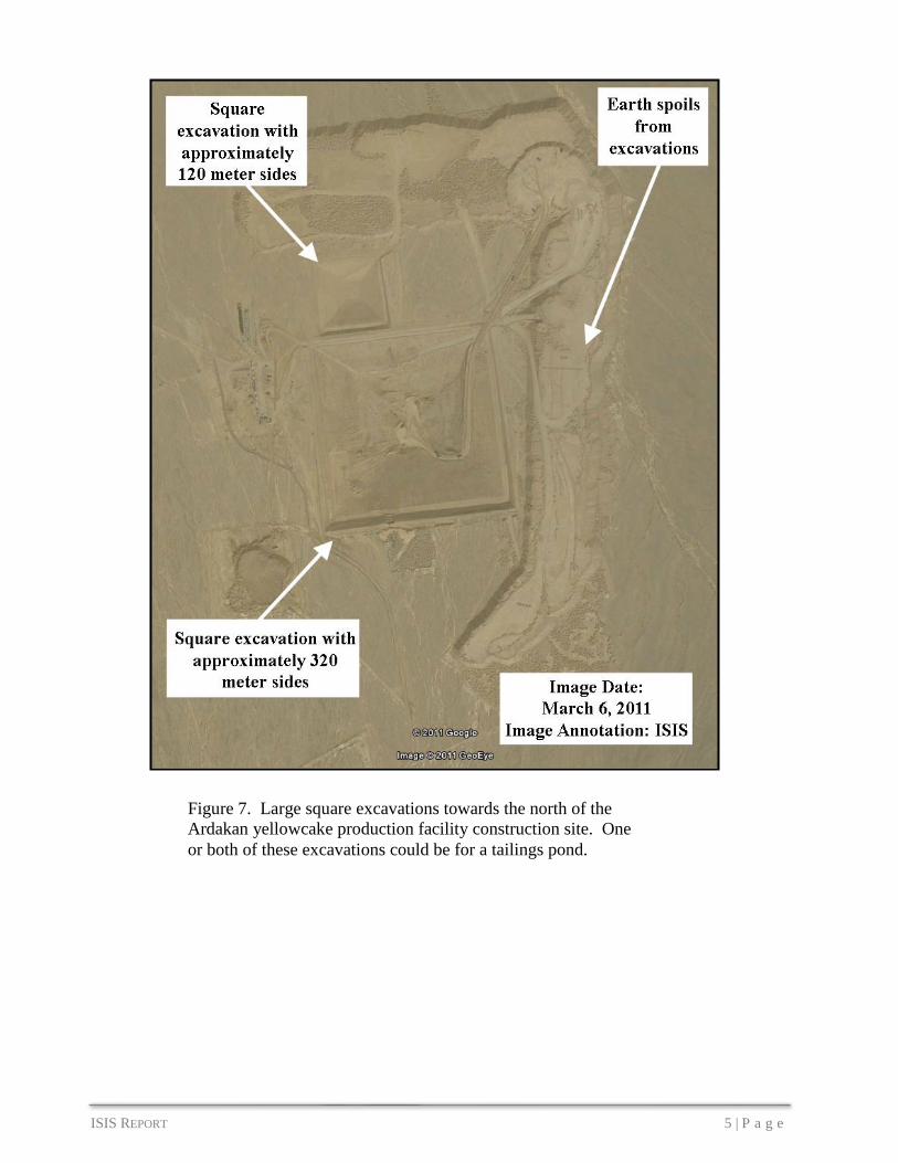
In August 2011, Google Earth added imagery from March 6, 2011 of the Ardakan yellowcake
production plant. The facility is being constructed very slowly, with few buildings added each
year. Comparing the new imagery to a picture from October 2009, a few more buildings have
been constructed (see figures 5 and 6). Two large square excavations can be seen here (see
figure 7). One or both of these excavations could be for a tailings pond. A building towards
the south of the site, under construction in previous imagery, now appears to be a hardened
facility (see figures 8 and 9).

ISIS REPORT 2 | P a g e
Figure 1. The Arak reactor and heavy water production site in November 25, 2009.
Figure 2. Arak reactor and heavy water production site in new Google Earth imagery June 22, 2010. There
do not appear to be major external changes to the site—though construction inside the buildings is ongoing.

ISIS REPORT 3 | P a g e
Figure 3. Tailings pond
full in February 9, 2010
image of the Gchine
uranium mine and mill
site.
Figure 4. Tailings pond
empty in November 8, 2010
image of the Gchine uranium
mine and mill site.

ISIS REPORT 4 | P a g e
Figure 5. Ardakan yellowcake
production facility under
construction in this October 6, 2009
satellite image.
Figure 6. Several new buildings are under
construction in this new image from March 6,
2011 recently added to Google Earth.
ISIS REPORT 5 | P a g e
Figure 7. Large square excavations towards the north of the
Ardakan yellowcake production facility construction site. One
or both of these excavations could be for a tailings pond.

ISIS REPORT 6 | P a g e
Figure 8. October 6, 2009 satellite
image shows building under
construction at southern end of
Ardakan site.
Figure 9. March 6, 2011 satellite
image showing the hardened
facility.