Embed Size (px)
Citation preview

Newcastle International Airport
Airspace Change Proposal
Standard Terminal Arrival Route (STAR)
And
PRNAV – GNSS approaches

INTENTIONALLY LEFT BLANK

Airspace Change Proposal: STAR and PRNAV
08 November 2017 Issue 1 3 of 36 Author: Simon Rhodes
Table of Contents
Table of Figures ....................................................................................................................................... 4
Definitions ............................................................................................................................................... 5
Introduction ............................................................................................................................................ 6
CHAPTER 1: Operational Requirements ............................................................................................. 9
1. Justification for the Change and Analysis of Change ...................................................................... 9
2. Airspace Description ..................................................................................................................... 12
3. Supporting Infrastructure/Resources ........................................................................................... 13
4. Operational Impact ....................................................................................................................... 14
5. Economic Impact ........................................................................................................................... 14
6. Safety Management ...................................................................................................................... 14
7. Airspace and Infrastructure Requirements ................................................................................... 15
8. Supporting Maps, Charts and Diagrams ....................................................................................... 15
CHAPTER 2: Environmental Report .................................................................................................. 25
1. Description of Airspace Change .................................................................................................... 25
2. Traffic Forecasts ............................................................................................................................ 25
3. Effects on Noise ............................................................................................................................ 26
4. Change in Fuel Burn / CO2 ............................................................................................................. 27
5. Local Air Quality ............................................................................................................................ 27
6. Tranquillity and Visual Intrusion ................................................................................................... 28
7. Economic Valuation of Environmental Impact ............................................................................. 28
8. Economic Benefit to NIAL ............................................................................................................. 28
CHAPTER 3: Consultation Report ...................................................................................................... 31
1. Executive Summary ....................................................................................................................... 31
2. Communication Methods ............................................................................................................. 31
3. Overview of Responses ................................................................................................................. 33
4. Summary of Respondents ............................................................................................................. 34
5. Modifications to the Proposal....................................................................................................... 35
6. Supporting Documentation .......................................................................................................... 35
Appendices are indexed in Chapter 3, Para 6.

Airspace Change Proposal: STAR and PRNAV
08 November 2017 Issue 1 4 of 36 Author: Simon Rhodes
Table of Figures
Figure 1: NATS Traffic Orientation Scheme Airway P18 ....................................................................... 10
Figure 2: Extract of UK AIP Chart AD 2-EGNT-4-1 (3 Mar 2016) showing location of Currock Hill ....... 10
Figure 3: Radar screen shot showing active Currock Hill areas for Runway 07 operations at NIAL ..... 11
Figure 4: Extract of UK AIP Chart ENR 6-1-6-6 (17 Aug 2017) showing Airway P18 ............................. 13
Figure 5: Radar screenshot showing STAR and Runway 07 PRNAV transition ..................................... 16
Figure 6: Radar screenshot showing STAR and Runway 07 PRNAV transition (Including Currock Hill
Gliding Site) ........................................................................................................................................... 17
Figure 7: Radar screenshot showing STAR and Runway 25 PRNAV transition ..................................... 18
Figure 8: STAR overlaid onto Google Maps .......................................................................................... 19
Figure 9: PRNAV approaches to both runways overlaid on Google Maps ............................................ 20
Figure 10: Typical Inbound Routes to NIAL using ATC Vectors ............................................................. 21
Figure 11: Typical Inbound to Runway 07 (ATC Vectors): October 2017 ............................................. 22
Figure 12: Typical Inbound to Runway 25 (ATC Vectors): October 2017 ............................................. 22
Figure 13: Close up of PRNAV 25 overlaid on Google Maps over South Shields .................................. 23
Figure 14: Close up of PRNAV 07 overlaid on Google Maps showing Currock Hill gliding areas .......... 24
Figure 15: Movement forecast up to 2035 ........................................................................................... 25
Figure 16: Passenger number forecast up to 2035 ............................................................................... 26
Figure 17: CDO Performance at Newcastle from Jan 2013 to Sept 2017 ............................................. 27
Figure 18: Screenshot of Morpeth Herald Article on Airspace Consultation ....................................... 32
Figure 19: Breakdown of Respondents ................................................................................................. 34
Figure 20: Google Map showing breakdown of Individual Respondents who provided Postcodes .... 34
Figure 21: Breakdown of Responses ..................................................................................................... 35
Airspace Change Proposal: STAR and PRNAV
08 November 2017 Issue 1 5 of 36 Author: Simon Rhodes
Definitions
ACP Airspace Change Proposal
AIP Aeronautical Information Publication
ATC Air Traffic Control
ATS Air Traffic Services
CAA Civil Aviation Authority
CAP Civil Aviation Publication
CDO Continuous Descent Operations
CTA Control Area
DAP Department for Airspace Policy (see now SARG)
DTVA Durham Tees Valley Airport
ECAC European Civil Aviation Conference
FAF Final Approach Fix
GA General Aviation
GNSS Global Navigation Satellite System
H24 24 hours per day
IAF Initial Approach Fix
ICAO International Civil Aviation Organisation
LoA Letter of Agreement
NDB Non-Directional Beacon
NIALL Newcastle International Airport Ltd
PANS-OPS Procedures for Air Navigation Services - Aircraft Operations
PBN Performance Based Navigation
PRNAV Precision-Area Navigation
SARG Safety and Airspace Regulation Group
SARPS Standards and Recommended Practices
ScATCC Scottish Area Terminal Control Centre (NATS based in Prestwick)
SES Single European Sky
SID Standard Instrument Departure
SMS Safety Management System
STAR Standard Terminal Arrival Route
VOR Very High Frequency Omni-directional Range
WAM Wide Area Multilateration
Airspace Change Proposal: STAR and PRNAV
08 November 2017 Issue 1 6 of 36 Author: Simon Rhodes
Introduction
1.1. This document details a proposal to establish a more accurately defined arrival route, STAR,
to Newcastle International Airport Ltd (NIAL) within controlled airspace. The STAR will
be suitable for aircraft arriving to either runway at Newcastle from the airway structure to
the south. The STAR leads to a transition route for both runways and then a PRNAV
(GNSS) approach to LPV200 standard. NIAL is looking to implement these procedures in
AIRAC 05/2018 with an implementation date of 26 APR 2018.
1.2. A STAR is a standard ATS route identified in an approach procedure by which aircraft
should proceed from the en-route phase to an initial approach fix. STARs are produced with
the object of expediting the safe and efficient flow of air traffic operating to the same or
different Runways at the same or neighbouring airfields and aims to deconflict potentially
conflicting traffic by the use of specific routings, levels and check points. Typically, each
Runway will have a number of STARs to ensure that air traffic is not unnecessarily delayed
by deviation from the direct route to the aerodrome. The traffic orientation scheme to the
south west of Newcastle has dictated the design of only one STAR that will be used for
approaches to both runways (Runway 25 and Runway 07).
1.3. CAP 725, “CAA Guidance on the Application of the Airspace Change Process” gives
guidance to Sponsors, in this case NIAL, on the stages (1 to 4) for completion of the process
for submission of an Airspace Change Proposal (ACP). NIAL has followed this process.
1.4. Stage 1 of the process was completed in January 2015 when NIAL conducted a Framework
Briefing Meeting with DAP. As a result of the meeting NIAL decided to proceed with the
ACP to establish a STAR and PRNAV (GNSS) approaches for aircraft arriving at NIAL.
This decision was confirmed in writing to DAP. There was a further meeting with DAP and
our IFP designers (PILDO) on the 14th of June 2017 with a follow up conference call on the
15th of September 2017.
1.5. The STAR and PRNAV (GNSS) approaches have been discussed at length with based
airlines through scheduled meetings and numerous conversations. The airlines are very
supportive of our plans and we have had offers to flight trial and validate the new
procedures in simulators. The advantages to airlines of using PRNAV and low power low
drag approaches and we are following current DfT guidance (CAP725) in their
implementation.
“easyJet welcomes the opportunity to comment on the ACP having worked alongside the airport for a number of years on this project. The introduction of such procedures will bring Newcastle in line with other regional and larger airports and this type of approach is essential for future airspace management and the most modern aircraft that we fly. The
new procedures will allow the use of navigation legs by which the aircraft can fly a fixed and curved path over the ground. The benefits lie in more efficient route spacing and better noise abatement compliance. easyJet fully support
this airspace improvement.”
Steve Freeman: easyJet Newcastle Base Captain
1.6. The ACP was developed as set out in Stage 2. It was decided that the most appropriate
method of consultation would be the publication of a written consultation document with
appropriate questions. The Consultation Document “Implementation of a Standard Terminal
Arrival Route (STAR) at Newcastle International Airport” was sent to the identified list of
consultees, including DAP, in March 2017 with a request to respond by 2nd June 2017. A
copy of the Consultation Document is attached as Appendix A.

Airspace Change Proposal: STAR and PRNAV
08 November 2017 Issue 1 7 of 36 Author: Simon Rhodes
1.7. All responses to the Consultation have been collated, analysed and recorded. This document
complies with Stage 4 of the application of the ACP Process, the submission of a Formal
ACP to DAP by detailing a proposal to establish a more accurately defined arrival route,
STAR and PRNAV (GNSS) approaches to NIAL within controlled airspace.

Airspace Change Proposal: STAR and PRNAV
08 November 2017 Issue 1 8 of 36 Author: Simon Rhodes
INTENTIONALLY LEFT BLANK
Airspace Change Proposal: STAR and PRNAV
08 November 2017 Issue 1 9 of 36 Author: Simon Rhodes
CHAPTER 1: Operational Requirements
1. Justification for the Change and Analysis of Change
1.1. Newcastle International Airport (NIAL) is a major Regional Airport. Notwithstanding the
current economic climate and the recent downturn in traffic NIAL is forecast to continue
long-term growth. Growth of traffic at NIAL has, in general terms, been sustained
throughout the Airport’s history. In 2016 the Airport handled 59,000 movements in total.
1.2. Currently, all aircraft on approach to NIAL are guided by verbal instructions from Air
Traffic Controllers. Implementation of a STAR will allow aircraft that are suitably equipped
to use ‘Area Navigation’ PRNAV based flight procedures for their approach towards NIAL.
These flights will still be monitored by the controllers and the controllers can issue
instructions if necessary just as they do now.
1.3. Implementation of a STAR at NIAL will offer the opportunity for more efficient flight by
those aircraft that follow the STAR, potentially saving fuel costs and reducing CO2
emissions – a government priority for aviation and one of the CAA’s Strategic Objectives by
“Improving environmental performance through more efficient use of airspace and (to)
make an efficient contribution to reducing the aviation industry’s environmental impacts.”
1.4. Use of a STAR at Newcastle is in accordance with UK and EU policies on Performance
Based Navigation (PBN) being “an essential component of delivering the objectives
underpinning the Future Airspace Strategy and consequential modernisation of the UK
airspace system…..laying the foundations for the airspace system not just of tomorrow, but
for years to come….” (CAA – Performance Based Navigation).
1.5. There is no change proposed to the existing airspace infrastructure. The STAR and PRNAV
(GNSS) approaches are designed to work within the parameters of currently established
airspace.
1.6. The options considered by Newcastle were to do nothing, design and propose 2 STARs, one
for each Runway (25 and 07) or design and propose a single STAR with an IAF at the end
of the STAR that could be used for either Runway. The “Do Nothing” option was rejected
as it would delay compliance with UK and EU policies on PBN. Initially, it was proposed
that 2 STARs be designed: one for each Runway. However, as NIAL inbound, and outbound
routings via P18 (see Airspace Description below), must conform to a Traffic Orientation
Scheme implemented by NATS for high level aircraft overflying the North East Region the
difficulties presented to NIAL by the requirement to comply with the Traffic Orientation
Scheme, an agreement on airspace usage with the operators of a gliding site 9NM to the
South West of the airport and separation from aircraft using the Runway 07 SID which
terminates at FL80 it was agreed that a single STAR descending to FL90 presented the best
solution.

Airspace Change Proposal: STAR and PRNAV
08 November 2017 Issue 1 10 of 36 Author: Simon Rhodes
Figure 1: NATS Traffic Orientation Scheme Airway P18
Figure 2: Extract of UK AIP Chart AD 2-EGNT-4-1 (3 Mar 2016) showing location of Currock Hill
Airspace Change Proposal: STAR and PRNAV
08 November 2017 Issue 1 11 of 36 Author: Simon Rhodes
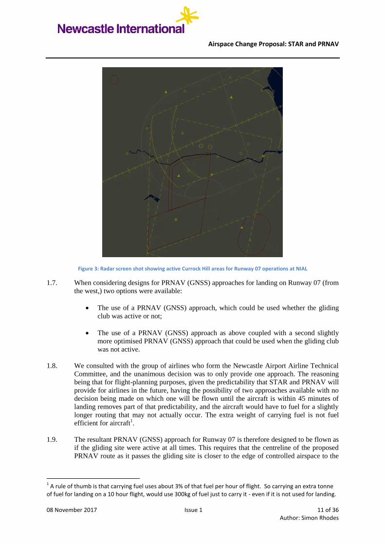
Figure 3: Radar screen shot showing active Currock Hill areas for Runway 07 operations at NIAL
1.7. When considering designs for PRNAV (GNSS) approaches for landing on Runway 07 (from
the west,) two options were available:
The use of a PRNAV (GNSS) approach, which could be used whether the gliding
club was active or not;
The use of a PRNAV (GNSS) approach as above coupled with a second slightly
more optimised PRNAV (GNSS) approach that could be used when the gliding club
was not active.
1.8. We consulted with the group of airlines who form the Newcastle Airport Airline Technical
Committee, and the unanimous decision was to only provide one approach. The reasoning
being that for flight-planning purposes, given the predictability that STAR and PRNAV will
provide for airlines in the future, having the possibility of two approaches available with no
decision being made on which one will be flown until the aircraft is within 45 minutes of
landing removes part of that predictability, and the aircraft would have to fuel for a slightly
longer routing that may not actually occur. The extra weight of carrying fuel is not fuel
efficient for aircraft1.
1.9. The resultant PRNAV (GNSS) approach for Runway 07 is therefore designed to be flown as
if the gliding site were active at all times. This requires that the centreline of the proposed
PRNAV route as it passes the gliding site is closer to the edge of controlled airspace to the
1 A rule of thumb is that carrying fuel uses about 3% of that fuel per hour of flight. So carrying an extra tonne
of fuel for landing on a 10 hour flight, would use 300kg of fuel just to carry it - even if it is not used for landing.
Airspace Change Proposal: STAR and PRNAV
08 November 2017 Issue 1 12 of 36 Author: Simon Rhodes
West. This means that aircraft will descend from a slightly higher flight level to provide
adequate safety margin above the gliding site.
1.10. The PRNAV (GNSS) approach for Runway 25 effectively replicates and more accurately
defines the current routing being flown by aircraft inbound from Airway P18. Approaches
from the south east, east, north and west, will make an approach to one of the fixes2 either to
the south or north of the final approach fix as appropriate. Again – there would be no change
to existing tracks, but these points are further east and offshore than are currently flown, and
will therefore be taking aircraft away from those coastal communities currently being
overflown.
1.11. The difficulties presented by the requirement to comply with the Traffic Orientation
Scheme, the requirement to ensure separation against outbounds and the LoA with
Northumbria Gliding Club have all had some effect on the final proposal for the PRNAV
(GNSS) approach for Runway 07. During the whole design process, the Airport has worked
hard to ensure the minimum potential disruption to communities within the affected areas.
2. Airspace Description
2.1. Airway P18 extends from the Pole Hill VOR (POL) to NATEB. It is 14nm wide and
consists of both Class A and Class D airspace and is available H24. Within the parameters
of P18, the base of Class A airspace is FL125.
2.2. Between NATEB and UVAVU, P18 consists of Class D airspace with a base of FL75 from
TILNI to the boundary of the Newcastle CTA, and a base of FL125 above the CTA to
NATEB. Below these portions of P18 are the parts of the Newcastle CTA, also Class D with
varying base levels.
2.3. Class A airspace between UVAVU and NATEB is delegated by ScATCC North Upper
Sector to Newcastle Radar from FL125 up to FL165.
2.4. The proposal is to establish a STAR within the confines of P18, to the east (right) of the
Airway centre line from abeam ABKAT to abeam GIRLI from FL130 to FL90.
2.5. The proposed STAR will be available to aircraft approaching NIAL along Airways P18 and
Y250 24 hours per day, 7 days per week.
2.6. The STAR will conform to the requirement to route NIAL inbounds up the east side of
Airway P18. There are no airspace buffer requirements. The proposed PRNAV (GNSS)
transitions and approaches remain wholly within controlled airspace.
2.7. The STAR complies with the official ICAO definition (PANS-OPS/1 Amendment 9 1996)
in that it will be a designated Instrument Flight Rule (IFR) arrival route linking a significant
point, on an Air Traffic Service (ATS) route with a point from which a published instrument
approach procedure can be commenced, in this case the FAF.
2 A ‘fix’ is a point in space that is used to define a position on a route. Often fixes are used to make a point
where the next phase of flight will start - for example, the Initial Approach Fix from where their approach will commence.

Airspace Change Proposal: STAR and PRNAV
08 November 2017 Issue 1 13 of 36 Author: Simon Rhodes
Figure 4: Extract of UK AIP Chart ENR 6-1-6-6 (17 Aug 2017) showing Airway P18
3. Supporting Infrastructure/Resources
3.1. Newcastle ATC is equipped with primary and secondary surveillance sources:
Primary Radar - Thales Star 2000;
Windfarm infill radar - Terma Scanter 4002;
Secondary Radar - ERA WAM.
3.2. Radar is available at Newcastle H24.
3.3. In the unlikely event of radar failure non-radar procedures are implemented. NIAL has
designed these non-radar procedures whereby aircraft will be placed in the hold in NIAL
overhead, and once within the protection of NIAL controlled airspace, transferred for a
procedural arrival.
3.4. There are two inbound frequencies: primary (Newcastle Radar) 124.375 and (Newcastle
Director) 125.825. NIAL has two sets of transmitters and receivers and also handheld/base-
station back-ups. There are Contingency Procedures which incorporate the current Non-
Radar Procedures, but effectively involve ATC relocating to a Contingency Facility which is
located in the old ATC tower.

Airspace Change Proposal: STAR and PRNAV
08 November 2017 Issue 1 14 of 36 Author: Simon Rhodes
3.5. Newcastle ATC is operational 24 hours per day, 7 days per week and is published as such.
3.6. Manning is in accordance with the guidance given in CAP670. There are 24 Air Traffic
Controllers working a standard 5 watch, 10 day cycle shift pattern of 2 earlies, 2 lates, 2
nights, sleep day and 3 days off. There are 7 Air Traffic Support Officers.
3.7. There is also a Manager Air Traffic Control who provides operational cover as required.
4. Operational Impact
4.1. As no new airspace is being proposed there would be no impact on General Aviation, which
includes smaller aircraft such as private aircraft or those of flying schools with no
restrictions to clearances and routings. Similarly there would be no impact on military
aviation. No new airspace is being requested and no restrictions on clearances or routings
are being proposed. Existing LoAs between NIAL and GA / Military stakeholders will be
unaffected.
4.2. There was an intention to revise our letter of agreement with Durham Tees Valley (DTVA)
to allow the STAR to descend to FL130 but this was not achievable as DTVA’s departing
traffic wishes to join P18 at GASKO climbing to FL130. DTVA couldn’t mitigate the risk
of our STAR traffic descending to FL130 so the LoA remains as it was and our STAR is
designed to not be below FL140 until the aircraft is 5nm north of the extended centreline to
Runway 23 at DTVA as detailed in our letter of agreement (see Appendix C).
5. Economic Impact
5.1. Incorporating CDO into the STAR procedures generates a number of benefits. It reduces the
amount of fuel burned by approaching aircraft and lower power settings on the engines
required for descent as opposed to level flight reduces “wear and tear” thus reducing
maintenance costs.
5.2. As a result of lower power settings during descent, it will be anticipated this will reduce the
impact of noise and CO2 / fuel burn as described in Chapter 2. This will be of benefit to the
airlines using Newcastle Airport.
6. Safety Management
6.1. Newcastle is operating an SMS in accordance with the provisions laid down in CAP 670 -
ATS Safety Requirements - and in the Single European Sky Common Requirements (CRs)
6.2. The Newcastle Air Traffic Services SMS is a formal organisational system designed to
manage operational safety within the ATS department. It integrates a suite of active safety
management tools including senior management commitment, hazard identification and risk
management, safety reporting, audit, investigations, remedial actions, safety culture and
education supported by clear policies and processes.
6.3. There is no change to the dimensions of current airspace. For changes to procedures, as part
of the Airport’s Change Management process, an impact assessment on the introduction of
the proposed STAR and PRNAV (GNSS) approaches has been conducted to ensure
compliance with the requirements of the SMS in line with CAP670: ATS Safety
Requirements.

Airspace Change Proposal: STAR and PRNAV
08 November 2017 Issue 1 15 of 36 Author: Simon Rhodes
6.4. In the event that the primary radar fails the PRNAV (GNSS) approaches will be withdrawn
because of their proximity to the boundary of controlled airspace to the west of Newcastle.
Aircraft will then be vectored for an ILS It is also in the letter of agreement with Currock
Hill that in the event of a primary radar failure Currock Hill glider site will close.
6.5. In the event that an aircraft suffers a radio failure whilst flying the STAR, on reaching
ETSES the aircraft is to maintain FL90 route to the NT hold. If the aircraft suffers radio
failure during transition or on final approach the aircraft is to continue with the approach.
This is to be annotated on the STAR and PRNAV (GNSS) charts.
7. Airspace and Infrastructure Requirements
7.1. The proposed STAR complies with the Airspace and Infrastructure Requirements as derived
from SES Regulations, ICAO SARPs and ECAC/Eurocontrol requirements, and any
additional requirements to satisfy UK Policy.
7.2. There is no change proposed to the existing airspace infrastructure. The STAR is designed
to work within the current structure. As the proposed STAR will be embedded within
Airway P18 the airspace will be of sufficient dimensions with regard to expected aircraft
navigation performance and manoeuvrability to fully contain horizontal and vertical flight
activity in both radar and non-radar environments. Furthermore, since the proposed STAR is
contained within an existing route (Airway P18) there is sufficient accurate navigational
guidance based on in-line VOR/DME or NDB or use of P-PRNAV to allow aircraft to
navigate within the STAR. In addition, it is anticipated that aircraft following the STAR will
conduct a CDO to at least the FAF. Indeed, 81.4% of aircraft carried out CDOs during 2016
and the implementation of a STAR will formalise this procedure. The new procedure will be
designed to incorporate CDO profiles from the commencement of the STAR. Transitions to
the FAF have been designed to facilitate the CDO profiles.
7.3. From CAP 725: The DfT guidance (DTLR, 2002 - paragraph 49) requires DAP to 'ensure
that consideration is given to how the use of Continuous Descent Approaches and Low
Power/Low Drag (LPLD) procedures can be promoted in the course of developing new
procedures and when considering proposals for changes to existing airspace arrangements'.
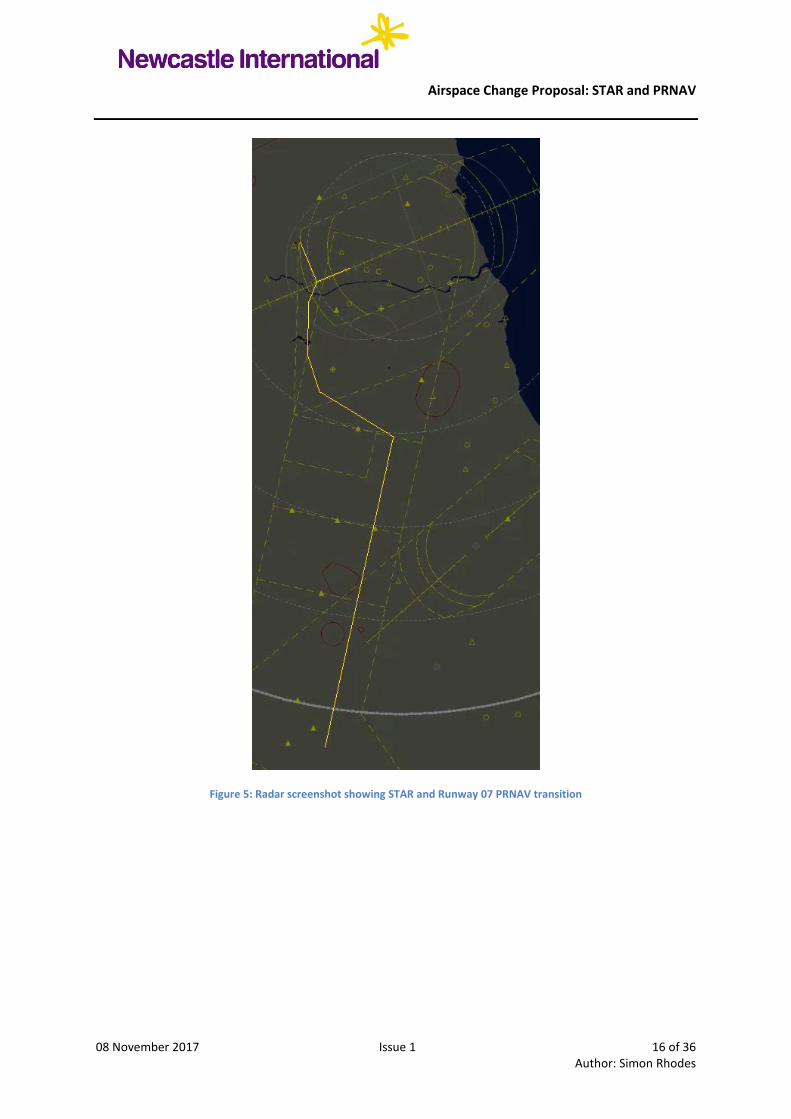
8. Supporting Maps, Charts and Diagrams
8.1. As the new charts do not show the route in comparison to existing controlled airspace as
highlighted by NATS in one of the consultee responses (see Appendix E for all consultee
responses), the latitude and longitude of all points on the STAR and PRNAV transitions for
both runways were overlaid onto the existing radar video map. These can be seen in Figure
5, page 16 (Runway 07) and Figure 7, page 18 (Runway 25).
Airspace Change Proposal: STAR and PRNAV
08 November 2017 Issue 1 16 of 36 Author: Simon Rhodes
Figure 5: Radar screenshot showing STAR and Runway 07 PRNAV transition

Airspace Change Proposal: STAR and PRNAV
08 November 2017 Issue 1 17 of 36 Author: Simon Rhodes
Figure 6: Radar screenshot showing STAR and Runway 07 PRNAV transition (Including Currock Hill Gliding Site)
8.2. The PRNAV approach to Runway 07 was designed to route overhead the most southern area
at Currock Hill (referred to as Area 2 in the LoA: see Appendix D), before passing west of
the northern area (referred to as Area 1 in the LoA) as shown in Figure 6 on page 17. A
close up of this arrangement against a Google Maps overlay is depicted in Figure 11 on page
24.

Airspace Change Proposal: STAR and PRNAV
08 November 2017 Issue 1 18 of 36 Author: Simon Rhodes
Figure 7: Radar screenshot showing STAR and Runway 25 PRNAV transition
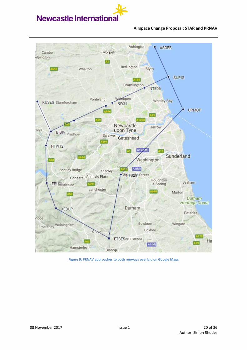
8.3. To show the route of the STAR and PRNAV approaches against built up areas, it was
plotted on Google Maps and is shown in Figure 8, page 19 and Figure 9, page 20.

Airspace Change Proposal: STAR and PRNAV
08 November 2017 Issue 1 19 of 36 Author: Simon Rhodes
Figure 8: STAR overlaid onto Google Maps
Airspace Change Proposal: STAR and PRNAV
08 November 2017 Issue 1 20 of 36 Author: Simon Rhodes
Figure 9: PRNAV approaches to both runways overlaid on Google Maps

Airspace Change Proposal: STAR and PRNAV
08 November 2017 Issue 1 21 of 36 Author: Simon Rhodes
8.4. This compares to the existing radar vectors offered by ATC as shown by track data obtained
by the NIAL Noise Desk software as seen in Figure 10 below.
Figure 10: Typical Inbound Routes to NIAL using ATC Vectors
8.5. Comparisons from inbounds to Runway 07 (Figure 11, page 22) and Runway 25 (Figure 12,
page 22) i.e. aircraft being vectored for an ILS are shown along with their recorded altitudes.
When comparing against the proposed designs for the transitions and PRNAV (GNSS)
approaches in Figure 9, the track over the ground is very similar.

Airspace Change Proposal: STAR and PRNAV
08 November 2017 Issue 1 22 of 36 Author: Simon Rhodes
Figure 11: Typical Inbound to Runway 07 (ATC Vectors): October 2017
Figure 12: Typical Inbound to Runway 25 (ATC Vectors): October 2017

Airspace Change Proposal: STAR and PRNAV
08 November 2017 Issue 1 23 of 36 Author: Simon Rhodes
8.6. One of the consultation responses asked how the route would look over South Shields with
particular reference to the City Centre. The navigation points were overlaid onto Google
Maps to give this image. Flights would be routing from left to right in Figure 10 below.
Figure 13: Close up of PRNAV 25 overlaid on Google Maps over South Shields

Airspace Change Proposal: STAR and PRNAV
08 November 2017 Issue 1 24 of 36 Author: Simon Rhodes
8.7. Northumbria Gliding Club (Currock Hill) is shown by the glider symbol in Figure 11 below
with Area 1 shown in red and Area 2 shown in orange. The maximum height of both areas is
5,000 AMSL on the Newcastle QNH. A local agreement and approval from SARG allows
NIAL ATC to descend IFR arrivals to 5,500 feet AMSL until clear of the gliding areas,
hence the level restriction of not below 5,500 feet at ERUXI.
Figure 14: Close up of PRNAV 07 overlaid on Google Maps showing Currock Hill gliding areas
8.8. A complete set of the charts for the proposed procedures can be found in Appendix J.

Airspace Change Proposal: STAR and PRNAV
08 November 2017 Issue 1 25 of 36 Author: Simon Rhodes
CHAPTER 2: Environmental Report
1. Description of Airspace Change
1.1. The physical dimensions of controlled airspace are not changing. The proposed STAR and
PRNAV approaches to both Runway 25 and Runway 07 mimic the vectors that ATC give to
aircraft on approach to Newcastle. They have been designed to remain inside controlled
airspace and follow, as much as possible, an optimum route for aircraft to fly CDOs and
approach to land safely.
2. Traffic Forecasts
2.1. The graphs below show that movements and therefore associated passenger numbers are
both expected to continue with strong growth in the next 18 years. Whilst airports with
longer runways could expect larger passenger numbers without much associated movement
growth due to larger aircraft being utilised, NIALL does not have a long enough runway to
support the larger aircraft on the market hence a correlation growth with aircraft movements
against passenger numbers. Having efficient arrival and departure procedures is essential to
minimising delays to aircraft and therefore reducing the overall noise and carbon footprint.
The tables the data in Figure 12 and Figure 13 are extracted from tables which are available
as Appendix B.
Figure 15: Movement forecast up to 2035
60.0
65.0
70.0
75.0
80.0
85.0
2017 2019 2021 2023 2025 2027 2029 2031 2033 2035
Movements (perthousand)

Airspace Change Proposal: STAR and PRNAV
08 November 2017 Issue 1 26 of 36 Author: Simon Rhodes
Figure 16: Passenger number forecast up to 2035
3. Effects on Noise
3.1. There will be no noticeable increase in noise as aircraft will be above FL90 at the end of the
STAR. When transitioning to the PRNAV arrival, there should be a decrease in noise since
CDO is defined (Department for Transport et al, 2006a; NATS, 2006) as “a noise abatement
technique for arriving aircraft”, “The overall change to average noise impact experienced on
the ground being less than 1dB and at some distance from the Runway, is too small to be
accurately modelled. Changes of this magnitude (<1dB) to average noise is not normally
perceived as noticeable by most people.
3.2. One of the advantages of PRNAV is that those aircraft using PRNAV procedures will fly a
more predicable route, reducing the present ‘scatter’ of aircraft on approach. This will
slightly reduce the number of overflight events for the majority of people that are presently
overflown by aircraft on approach due to aircraft following a more defined route.
3.3. Those people living directly under the PRNAV procedures will see some additional aircraft
that are more directly overhead. The aircraft following the PRNAV procedures however,
will be flying higher because they will follow a CDO profile with reduced power settings,
thus making less noise than if they had overflown using present techniques.
3.4. The current noise contours remain relevant to this proposal, as the STAR flight path was
assumed within the modelling parameters for the contours, which were produced by the
Environmental Research and Consultancy Department (ERCD). Therefore, the outcome of
this proposal will not have a material impact on the contours. Noise contours were published
as part of the last Masterplan in 2013 and forecast developments up to 2030, copies can be
seen in Appendix I. A revised Masterplan, with updated noise contours will be published in
2018, as well as an updated Noise Action Plan.
5.00
5.50
6.00
6.50
7.00
7.50
8.00
8.50
9.00
9.50
10.00
Passenger numbers(per million)

Airspace Change Proposal: STAR and PRNAV
08 November 2017 Issue 1 27 of 36 Author: Simon Rhodes
4. Change in Fuel Burn / CO2
4.1. Climate change is a global concern. Carbon dioxide (CO2) has a half-life in our atmosphere
of hundreds of years and any avoidance of man-made contributions to atmospheric CO2 is
to be welcomed. CO2 is the principle aircraft emission species that affects climate change.
Aircraft CO2 emissions will be reduced if PRNAV is implemented at NIAL – and especially
if in combination with the proposed STAR. This is due to more efficient routings and
enhancements for CDO achievement. This is fully in-line with UK policy and international
commitments on Climate Change as well as NIAL’s plan to work towards accreditation to
Airport Council International’s3 Carbon Accreditation scheme. Aviation is coming under
increasing pressure to demonstrate real action on reducing its carbon emissions as evidenced
by the recent inclusion of aviation into the European Emissions Trading Scheme.
4.2. NIAL already monitor CDO performance by the airlines, and Figure 17 below shows the
performance from January 2013 to September 2017.
Figure 17: CDO Performance at Newcastle from Jan 2013 to Sept 2017
5. Local Air Quality
5.1. Particulate Matter (PM) and Oxides of Nitrogen (NOx) are the principle aircraft related
emissions that can affect local air quality. PRNAV will facilitate CDO and thus more
efficient aircraft routing which will reduce these atmospheric aircraft emissions. In
following CDO, aircraft can use less engine thrust which drastically reduces NOx
generation. For PM it is a little more complex, since the amount of particulates per kilo of
fuel burnt actually increases as thrust reduces. The overall effect of fuel reduction however
is far more significant and an overall (marginal) reduction of PM can be expected. The main
reductions in these types of emissions will arise further out, at above 3,000ft (i.e. beyond 10
miles out).
5.2. The United Nations (International Civil Aviation Organisation) have found that air quality
emissions emitted at 3,000ft above the ground or more play no significant part in local or
3 The main global association for civil airports.
0
10
20
30
40
50
60
70
80
90
100
Jan
-13
Ap
r-1
3
Jul-
13
Oct
-13
Jan
-14
Ap
r-1
4
Jul-
14
Oct
-14
Jan
-15
Ap
r-1
5
Jul-
15
Oct
-15
Jan
-16
Ap
r-1
6
Jul-
16
Oct
-16
Jan
-17
Ap
r-1
7
Jul-
17
Oct
-17
CD
O %
Month-Year
Airport Performance

Airspace Change Proposal: STAR and PRNAV
08 November 2017 Issue 1 28 of 36 Author: Simon Rhodes
regional air quality. Thus the benefit to air quality can be considered negligible; however
NIAL believes that the precautionary principle of reducing pollution whenever and
wherever possible is worthwhile at any altitude.
6. Tranquillity and Visual Intrusion
6.1. The PRNAV route will mirror the current operation and as such, aircraft will not be
operating in new areas. NIAL operate a Noise and Track Keeping (NTK) system, supplied
by Bruel and Kjaer which will provide the opportunity to monitor the PRNAV track. This
information will be monitored and shared with the Airline Technical Committee, the key
liaison group between NIAL and airlines. The area that would be overflown by the proposed
PRNAV procedures has been checked for sites where tranquillity is important such as tourist
attractions, hospitals, schools, open air venues etc. This was also discussed with local
councils via the NIAL Consultative Committee. Due to the aircraft being at higher levels
when following the procedures it is unlikely that there will be significant tranquillity issues.
7. Economic Valuation of Environmental Impact
7.1. For those flights that follow the PRNAV routes fuel and maintenance cost reductions for
airlines will arise from:
Reduced track miles flown;
Reduced engine thrust;
Reduced fuel used in carrying extra contingency fuel. Pilots presently fuel for a much
less direct route. Since the route using PRNAV can be pre-planned and is more direct,
the pilot can reduce how much fuel they need to carry. This improves the fuel
efficiency of the whole flight by reducing aircraft weight4 at take-off;
Reduced operating hours and wear and tear on aircraft and hence reduced
maintenance costs.
7.2. In trials conducted by Eurocontrol and others, fuel savings of up to 40% during the approach
phase have been demonstrated. This equates to between 50 and 150 kilogrammes of fuel
depending on the level at which CDO is commenced and the aircraft type.
7.3. According to the CDO implementation principles laid down in the ICAO CDO manual,
even partial continuous descent within individual sectors and at lower levels are still
worthwhile, with savings between 50 to 100 kilogrammes fuel per approach.
8. Economic Benefit to NIAL
8.1. NIAL is a key economic asset and important driver for the North East economy. NIAL
facilitates economic benefits including business links, inbound tourism and employment not
only at the airport but in all the businesses that rely on us. It also offers a gateway to the
world for local people. Operations that can help us to grow in a more sustainable way or to
reduce our environmental impact are good for the regional economy. One of the key benefits
4 As a rule of thumb it uses 3% extra fuel to carry fuel for each hour of flight. So on a 5 hour flight, typically
15kg of fuel is wasted for every 100kgs unnecessary fuel that is carried to landing.

Airspace Change Proposal: STAR and PRNAV
08 November 2017 Issue 1 29 of 36 Author: Simon Rhodes
from PRNAV is to significantly reduce the operating costs of airlines using NIAL through
fuel savings and shorter flying times.
8.2. The establishment of a STAR and PRNAV approaches will initially cost NIAL in monetary
outlay. However, savings may be made long term if the PRNAV approaches become an
alternative to our NDB approaches and it is decided that the NT NDB does not need
replacing. There are savings here if we do not replace this equipment in the procurement
cost, and also flight validation and maintenance costs. The implementation of the STAR
may also affect the decisions of airlines to open new routes or increase capacity on existing
ones as they can amend fuel calculations during flight planning to their own benefit.
Airspace Change Proposal: STAR and PRNAV
08 November 2017 Issue 1 30 of 36 Author: Simon Rhodes
INTENTIONALLY LEFT BLANK

Airspace Change Proposal: STAR and PRNAV
08 November 2017 Issue 1 31 of 36 Author: Simon Rhodes
CHAPTER 3: Consultation Report 1. Executive Summary
1.1. Newcastle International is the UK’s 11th busiest airport, serving 5.2 million passengers in
2017. The airport supports 3450 jobs on site and many more across the region and generates
£630m annually in to the regional economy.
1.2. The airport is located 6 miles north of Newcastle City Centre and has one east- west
Runway designated 07-25 with aircraft making approaches to both ends depending on wind
direction. The Runway is 2329m long allowing operations by most aircraft types. Most
movements are by Boeing 737 or Airbus A320 size aircraft but aircraft up to Boeing 777
size are regular users. Aircraft arriving at Newcastle are currently directed towards the
Runway by the radar controller which means that the aircraft will not always follow the
same track across the ground.
1.3. Newcastle prides itself on being the Most Welcoming Airport to our customers and are
always looking at new technologies that will improve the service provided, while at the
same time looking out for the interests of our neighbours.
1.4. Procedures using GPS signals (similar to a Satellite Navigation in a car) have been
developed for aircraft navigation and these are now starting to be rolled out both en-route
and in the airport environment. These procedures, known as PRNAV, allow the aircraft to
be flown far more accurately than conventional navigation techniques, lowering the fuel
burn for operators and reducing the overall noise footprint on the ground. It is the airports
intention to introduce these PRNAV procedures for arriving aircraft to take advantage of the
efficiency, safety and environmental benefits they offer to our customers and neighbours.
1.5. As key stakeholders the airport wants to give you the facts about what we are implementing
and give you a chance to ask questions or comment on any aspect of the project. Your
comments will allow us to ensure that what is implemented balances the needs of all our
stakeholders and gives the maximum benefits to everyone. Your views are very important to
us and we look forward to hearing your comments.
2. Communication Methods
2.1. Direct communication:
2.1.1. An email was sent to key Airport stakeholders (listed in Appendix H), which included
Parish Councils, Local Authorities and Airspace users. The email provided a direct link to
the consultation holding page on the NIAL website. All of the relevant documents were
available on this page and an option, to provide comments on a survey monkey portal.
2.1.2. The method of direct emails was followed up on a number of occasions to ensure that all
consultees were aware of the deadline date and the need to respond. We believe best
endeavours were made, to encourage responses for the consultation exercise.

Airspace Change Proposal: STAR and PRNAV
08 November 2017 Issue 1 32 of 36 Author: Simon Rhodes
2.2. Social media and Website:
NIAL have a strong presence on social media and this method proved very effective in the
consultation. A standard message was placed on both Twitter and Facebook, with the main
holding page on the NIAL website. The sponsored Facebook post reached 27,000 people
and achieved 1,500 link clicks, whilst the NIAL website consultation page had 13,836 total
views of which 5,423 were unique views. Examples of the messages received on Facebook
can be seen in Appendix G.
2.3. Video message:
2.3.1. A short video interview was produced with the Manager of Air Traffic Control, explaining
the aims of the consultation which was viewed 634 times. The following YouTube link was
displayed on the social media sites, to signpost the video:
https://www.youtube.com/watch?v=hi2XnbTF8F0
2.4. Libraries:
2.4.1. We accept that not everyone has access to a computer; therefore a brochure version of the
consultation was produced and sent to six key libraries in the area. A request was made to
have the document on view for local residents.
2.5. Press statement:
2.5.1. A press statement was released at the start of the consultation; however there was limited
interest from the media to run a story. An article did appear in the Morpeth Herald (see
Figure 15) and Graeme Mason, Planning and Corporate Affairs Director carried out a radio
interview with Radio Newcastle.
Figure 18: Screenshot of Morpeth Herald Article on Airspace Consultation

Airspace Change Proposal: STAR and PRNAV
08 November 2017 Issue 1 33 of 36 Author: Simon Rhodes
2.6. Drop in sessions:
2.6.1. There were two drop in sessions held at the Airport, in total three members of the
community attended and they did not object to the proposal.
2.7. Airport Consultative Committee:
2.7.1. As a key stakeholder, the Airport Consultative Committee received regular updates on the
ACP process and a presentation outlining the arrival and approach procedures. At the
request of Dinnington Parish Council, members of the Airport team presented at their PC
meeting.
2.8. Airline Technical Committee:
2.8.1. Again, the Airline Technical Committee (which is made up of based airlines) were given
regular updates and a presentation on the ACP.
2.9. Local Authority meetings:
2.9.1. Direct meetings were held with South Tyneside, Durham, North Tyneside, Newcastle and
Northumberland Councils. Planning and Environmental Health officers attended the
meetings.
3. Overview of Responses
3.1. In total 92 responses were made to the consultation, with the majority of people responding
via the survey monkey application. All responses can be viewed in Appendix E.
3.2. Four formal objections were made from NATS, DTVA and two individuals.
Correspondence relating to the objections can be seen in Appendix F. Following dialogue
with one of the individuals they requested to withdraw their objection, however, for
transparency purposes we have noted this objection. The second individual questioned the
methodology for SIDS and STARS, rather than the NIAL proposal.
3.3. NIAL remain in close dialogue with NATS and DTVA to resolve their objection and work
together to implement the STAR PRNAV proposal and have already modified the proposal
as stated in Para 5.

Airspace Change Proposal: STAR and PRNAV
08 November 2017 Issue 1 34 of 36 Author: Simon Rhodes
4. Summary of Respondents
Figure 19: Breakdown of Respondents
4.1. The main based airlines Jet2, easyJet, Emirates, Thomson and Thomas Cook responded with
no objection. 20 Airspace users responded, with DTVA and NATS raising concerns.
4.2. A total of 56 individual residents responded with a number of positive comments, including
the following:
‘The new arrangements will mean that aircraft will no longer fly over my house in
Monkseaton. As an aviation enthusiast, this is disappointing. I welcome the sight of
overflying aircraft, as it acts as an important reminder to local residents and visitors that
Newcastle has an active and busy airport which they should use. Thankfully the views from
the beach of arriving aircraft should still be good.’
Figure 20: Google Map showing breakdown of Individual Respondents who provided Postcodes
Individual resident
Local Government
Airspace user
Parish Council orresidents group
Other
Private sector

Airspace Change Proposal: STAR and PRNAV
08 November 2017 Issue 1 35 of 36 Author: Simon Rhodes
4.3. We received 5 responses from Local Authorities, again all with support and no objection. 4
Parish Council / resident groups replied: this included a response from the Airport
Consultative Committee which represents all of the local Parish Councils. We attended a
local Parish Council meeting (Dinnington) and no objections were raised, however, they
failed to complete the survey response.
Figure 21: Breakdown of Responses
5. Modifications to the Proposal
5.1. As a result of the response received from Durham Tees Valley Airport, the initial level the
STAR commences was amended from FL130 to FL140 to facilitate traffic. The Letter of
agreement between Durham Tees Valley Airport and Newcastle airport can be found in
Appendix C.
6. Supporting Documentation
6.1. The following supporting documentation is attached as appendices:
Appendix A: Arrival and Approach Procedure: Consultation Document (March 2017). This is
a copy of the original proposal upon which consultation was conducted;
Appendix B: Passenger and Movements Forecast (Commercial In Confidence). This is an
Excel document showing the peak day forecasts for passenger and aircraft movements in
2020, 2025, 2030 and 2035 against the actual figures from 2016 and 2017. The table on the
first tab contains the data used for Figure 12 (page 25) and Figure 13 (page 26);
Appendix C: Letter of Agreement between Newcastle International Airport Ltd & Durham
Tees Valley Airport Ltd (Effective 1st April 2017). This details existing procedures between
NIAL and DTVA regarding traffic in Airway P18;
Appendix D: Letter of Agreement between Newcastle International Airport Ltd and
Northumbria Gliding Club (April 2016). This covers the procedures regarding the activation
of Currock Hill Gliding Site and the associated airspace co-ordinates;
Appendix E: Responses to the NIAL Consultation. This is a collation of all electronic
responses to the consultation in PDF format and NIAL responses where necessary.
88
4
0
20
40
60
80
100
Support and noobjection
Objection

Airspace Change Proposal: STAR and PRNAV
08 November 2017 Issue 1 36 of 36 Author: Simon Rhodes
Appendix F: Responses to the NIAL Consultation with objections. This is a collation of the
four responses which raised queries along with the NIAL responses where necessary.
Appendix G: Examples of Social Media Responses to NIAL Consultation. This is a selection
of comments from the NIAL Facebook page regarding the Airspace Change Consultation.
Appendix H: List of Organisations Consulted by Email. This includes whether responses
were received or not.
Appendix I: Noise Contours. A PDF document depicting Summer and Winter 2030 noise
contours.
Appendix J: Chart pack relating to the proposed procedures.