Embed Size (px)
Citation preview

Co-Sponsored by Colorado Water Institute, Colorado State University Agricultural Experiment Station, Colorado State University Extension, Colorado State Forest Service, and Colorado Climate Center
Newsletter of the Water Center of Colorado State UniversityNovember/December 2013 Volume 30, Issue 6
Theme: Water Storage and Development

Highlights2.6.8.
12.18.21.
1.23.25.27.29.31.34.35.36.37.
In Every Issue
Colorado Water is a publication of the Water Center at Colorado State University. The newsletter is devoted to enhancing communication between Colorado water users and managers and faculty at the state’s research universities. This newsletter is financed in part by the U.S. Department of the Interior, Geological Survey, through the Colorado Water Institute. The contents of this publication do not necessarily reflect the views and policies of the U.S. Department of the Interior, nor does mention of trade names or commercial products constitute their endorsement by the U.S. Government.
Front Cover: Morrow Point Dam, Colorado. Photo by Charles Carstensen This Page: Log Lane Water Tower. Photo by Bill Cotton
Phone: 970-491-6308 Fax: 970-491-1636 Email: [email protected]
Water Resources Specialists: Perry Cabot and Joel Schneekloth Research Associates: Faith Sternlieb and Julie Kallenberger
Director: Reagan M. WaskomAssistant to the Director: Nancy J. Grice
Policy & Collaboration Specialist:MaryLou SmithNonpoint Source Outreach Coordinator:Loretta Lohman
Published by: Colorado Water InstituteColorado State UniversityFort Collins, CO 80523-1033
Water Storage in Colorado: How it Developed—Toward the Future Neil Grigg
Denver Water Fixing Dam Safety Issues at AnteroAnn Baker
Northern Integrated Supply Project UpdateBrian Werner
September 2013 Front Range Flooding Event: Weather, Hydrologic Impacts, Context of a Changing Climate, Implications Jeff Lukas
The Soil, Water, and Plant Testing Laboratory at Colorado State UniversityJames Self
Reinvigoration of CSU Water CenterLindsey Middleton and Faith Sternlieb
EditorialReagan Waskom
Water Resources Archives An Archival Collaboration to Benefit the Colorado Water CommunityPatricia J. Rettig
Water Outreach Irrigation Pumping AssessmentsCary Weiner
Interviews ARCADIS Contributes to a CSU Water Research CenterLindsey MiddletonHistoryEverett V. Richardson, 1924-2013Hayley BrazierColorado State Forest ServiceBeetle-Kill Wood Product Reduces Post-Wildfire Runoff, ErosionRyan Lockwood
Faculty Profile: Jeffrey SteinerLindsey Middleton
Faculty Profile: David McLeanLindsey Middleton
Water Research Awards
Calendar
Editor: Lindsey A. MiddletonDesign: Kim N. Hudson

1
Editorial
Colorado Water — November/deCember 2013
Over two years ago, CSU President Tony Frank challenged several of his administrative officers
to think about how the university could better position itself in water for greatest impact. Dr. Frank’s question was prompted not by concern about current efforts, but by wanting to ensure that our future water programs will sustain excellence. Changing the organizational structure and culture of a large university does not happen overnight, as faculty tend to operate rather independently and move their research programs to where funding dictates. Therefore, change in a university setting, as in any organization, must be driven by a vision that aligns purpose, people, and values. When asked the secret of his success in hockey, Wayne Gretzky famously said, “A good hockey player plays where the puck is. A great hockey player plays where the puck is going to be.” The challenge for organizational leaders is to have a vision for where the “puck” is going to be, and to set a course in that direction.
Last year, Provost Rick Miranda sequentially activated two groups of faculty to begin analyzing current water programs at CSU and considering their future. Neil Grigg and Gene Kelly led the two groups, which resulted in a plan for investing in water programs at CSU and rejuvenating the CSU Water Center. CSU is not alone in this endeavor—interestingly, a number of universities around the U.S. are making major investments in their water programs. In Colorado alone, both Colorado Mesa University and Metropolitan State University of Denver recently developed new water centers, and other universities are discussing similar plans. It does not take unusual foresight to see how important water will be to the future economic and environmental well-being of both local and international populations. As a microcosm of many globally relevant water complexities, Colorado offers university faculty and students a unique laboratory for the study and resolution of internationally important issues related to water-scarce environments.
CSU’s water program was originally built on the juxtaposition of a highly engaged faculty and unique infrastructural capacity, including the Hydraulics Lab (completed in 1912), Engineering Research Center (ERC, started in 1958 when the Hydraulics Lab was moved to build the Lory Student Center), and the adjacent irrigated agriculture based around the Cache la Poudre River watershed. Additionally, Colorado’s geographic location as a headwaters state meant we took the lead in many important institutional and legal innovations. Today,
water problems facing society still require the sound engineering taught and practiced for so many years, but also disciplines like sociology, computer science, agronomy, economics, and many others. Modern day issues require that our graduates grapple with multiple disciplines and much complexity.
It is easy to confuse the Colorado Water Institute with the CSU Water Center. Both are located at CSU and deal with water, but the Water Institute has a mandate to work with all public institutions of higher education in the state on problems specific to Colorado. The mission of the CSU Water Center is to enhance connections in water within the university itself, specifically across all eight of CSU’s Colleges and within our three land grant mission areas—teaching, research, and extension. Significant changes in the new Water Center include that it is now faculty led and governed, and it has a closer relationship with SoGES (CSU School of Global Environmental Sustainability). Perhaps even more significant is the commitment of financial resources to the CSU Water Center that can be used to seed faculty and student projects. The expected outcome of implementing these strategies is a better-positioned CSU water program with increased resources and the capacity to serve in a nationally recognized leadership role in water. We expect these efforts will help build stronger linkages with private sector water businesses and our international alumni to create new opportunities for training and innovation at CSU. Our success will be determined by our ability to better serve our students, clientele, and the state of Colorado as an outcome of these investments.
2 the Water CeNter of Colorado State UNiverSity
Water Storage in Colorado How it Developed—Toward the Future
Neil Grigg, Civil and Environmental Engineering, Colorado State University
In many ways, we have a love-hate relationship with water storage
in Colorado—it supports our lives and economy, but water use also has environmental side effects that alter natural water systems. The importance of water storage is shown by the way it makes a large and growing population in the state possible. Early explorers such as Zebulon Pike and Stephen Long did not think that the Colorado climate could support many people, but now the state population is over five million and headed toward eight million by 2040 or soon thereafter, according to the Colorado Department of Local Affairs. Clearly, water storage enabled this growth, but now new issues and values must be confronted. To address them, this article discusses how much water storage we have, whether it is enough, whether new storage is essential, and the outlook for the future.
Water projects in Colorado have made a state with scarce and varying water resources into a region capable of supporting a large and growing population. Future projects are being proposed, but the benefits must be weighed against potential effects of such development.
Need for Water StorageGiven the vagaries of western water supply, securing water for new residents and a growing economy presents great challenges. In Colorado, the Statewide Water Supply Initiative (SWSI) report explains how the growing regions of the state will experience increasing degrees of shortage in the future unless more supplies can be developed or water demands are reduced, especially among agricultural users.
Storage does not add to the total water supply but like a savings account, it provides a place to hold excess water for later times when it is needed. Whereas precipitation falls more evenly in humid regions, our climate produces peaks and valleys of runoff and, unless some of the peak flows are stored, they are not available for use when needed. Fortunately, our mountain snowpack carries the water over for a few months naturally, but it still runs off quickly and is lost unless it is retained in storage buckets. It will never be possible to trap every drop of water, and as this is written, Colorado has just experienced record storm rainfall, much of which flowed out of the state. However, it is possible to store peak flows in most years and use the water for beneficial purposes later.
Some will object to water storage and even the notion of the water being lost because, as scientists explain, our ecosystems demand flushing water, and there are benefits to floods as they scour streams and nourish floodplains. Gilbert White, the water management sage who
lived in Boulder, always insisted on recognition of these beneficial effects when flood control was under discussion. Also, our downstream neighbors in other states depend on flows from our streams. These are good arguments for leaving some water and peak flows in streams, and there is a definite need to balance the storage of water with essential non-consumptive uses.
History of Colorado’s Water StorageCurrently, Colorado has a total installed capacity of about seven to eight million acre-feet (MAF) of water storage in reservoirs. This estimate is based on the capacity of some 6.8 MAF that is shown in the State Engineer’s database of reservoirs with 10,000 AF or more of storage and a guess that the many additional reservoirs with lower capacity will add about a million additional AF. This seems logical because the database shows some 109 reservoirs with greater than 10,000 AF, but it also shows 1,700 more reservoirs with smaller capacity. Most would not add much total storage, and many are regulating reservoirs used for water management, but not for long-term storage. The Dam Safety Branch of Colorado’s Division of Water Resources has a database showing approximately 1,965 dams greater than ten feet high at the spillway and impounding twenty acres or one hundred acre-feet or more at the high water line.
Many of our dams were built from about 1860 into the early 20th
Century, but most large capacity dams were built from the 1930s

3Colorado Water — November/deCember 2013
through 1970, many with federal assistance. Considering this history, Figure 1 shows the approximate growth of storage capacity and population over the years. The increase in storage in million acre-feet (MAF) over time is based on evaluation of the State Engineer’s dams database and reflects the rapid rise during the dam-building era from the 1930s to 1970. Subsequently, little storage has been constructed, with the denied 1990 permit for the proposed Two Forks dam being the state’s latest experience with attempts to add major storage capacity. Nighthorse Reservoir, at 123,000 acre-feet of capacity and completed in 2011, was the last major reservoir built in Colorado as part of the Animas-La-Plata Project. The storage estimates shown do not reflect loss
of capacity due to sedimentation or other aging factors of the dams and reservoirs.
You can see from the figure that since about 1970, the gap between population and water storage has widened dramatically. This gap must be interpreted by considering how early in our history, the greater storage relative to population was mostly used for agriculture, but now it is shifting to urban uses. Also, the gross storage shown does not reveal how it is used relative to population centers and needs. The conclusion is that while the overall gap looks alarming, the devil is in the details in the sense that it is important to note where the storage is located and how well it can be used to overcome water shortages. The storage estimates shown do not reflect loss of capacity
due to sedimentation or other aging factors of the dams and reservoirs.
Inventory of DamsColorado has about two percent of the nation’s regulated dams, or slightly more than our proportionate share on the basis of population. To see this, we can consult the U.S. Army Corps of Engineers National Inventory of Dams, which currently shows some 87,300 dams registered in the nation. These numbers shift from time to time, but the count of 1,737 in Colorado is comparable to the some 1,965 regulated dams in the State Engineer’s data base. Most of the listed dams in the nation have low hazard potential, but on the national scale, some 17 percent are considered at high hazard, which is determined by potential of loss of
Figure 1. Growth of population and water storage in Colorado

4
life, documented by the Interagency Committee on Dam Safety. In addition to the dams in the inventory, many other dams of low height and water storage exist, even down to small urban stormwater detention dams.
The use of water stored behind dams in the U.S. has been tabulated by the Association of State Dam Safety Officials (2013) for irrigation, electric power generation, flood control, municipal and industrial water, navigation, and recreation. Also, about 58 percent are privately owned, local governments own about 16 percent, state agencies own about four percent, and the federal government, public utilities, and undetermined interests own smaller numbers of dams. Federally
owned or constructed projects may not make up a large number, but they tend to be disproportionately large in capacity. Colorado’s dams also show a distribution across categories of ownership, but with relatively more federal dams, more irrigation dams, and fewer for electric power generation. Of course, none of our rivers is large enough for commercial navigation.
The largest Colorado reservoir, Blue Mesa, at 940 TAF, is located on the Gunnison River and not available for Front Range storage. The next
largest, Lake Granby, at 540 TAF, is also on the West Slope, and is used to bring water to the East Slope via the Colorado-Big Thompson Project. The next largest, McPhee Reservoir at 380 TAF, is in southwestern Colorado and not available for urban uses. Dillon Reservoir is fifth largest, at 254 TAF, and it is a key part of the Denver Water system (Figure 2). Next largest is John Martin Reservoir on the Arkansas River, at 233 TAF, but it is not upstream of any major urban areas. So of the top six reservoirs in size, only Dillon has significant dedication to urban uses. As a result of the ownership and location of the major reservoirs, storage capacity available and accessible to growing
urban needs is actually much less than the total.
Dillon Reservoir grew from a small natural lake after a dam was constructed in the 1960s. The reservoir is an important water source for Denver. Photo by Valerie Hudson

5Colorado Water — November/deCember 2013
integral part of the overall system, and the security needs of tunnels and interbasin transfer facilities will require heightened attention. Interconnection of systems and contingency plans are needed to boost security and add to options for responding to shortages. Using groundwater storage as a strategic reserve is another concept to boost security of supplies. Also, keeping enough stored water on the East Slope is wise, and will require enough capacity to see the region through emergencies of different kinds. The Metropolitan Water District of Southern California completed Diamond Valley Lake in 2003, a man-made offstream reservoir in Riverside County, at least partially to provide emergency storage in the event of an earthquake.
On an overall basis, using existing facilities better is an attractive concept, but the underlying issue is how to do it. Many technical methods are available, which include reduced demand, repair of leaks, use of graywater, and reuse of wastewater. While these sound good and have promise, the greater challenge is to find ways to work together and overcome the adversarial nature of the first in time, first in right management system. Much progress has been made in finding ways to do that, but a lot of work remains, particularly to increase flexibility for water users to gain access to water and to enable water transfers that are in everyone’s best interests.
The major challenge in Colorado water storage is the same as in water management in general—developing effective approaches to collaborate on using water for the common good while confronting many individual incentives and value-sets. It’s a tough challenge, but success in addressing it is imperative for the state’s future.
Proposals for New ReservoirsOver the past thirty years, a number of reservoir proposals have been considered in Colorado. During the 1980s, a series of reservoirs on the Poudre River was studied, but nothing was built and after a long conflict, a major part of the stream was declared as a Wild and Scenic River under federal law. Two Forks was the largest reservoir project to go through the Environmental Impact Statement process, and it was vetoed by the U.S. Environmental Protection Agency. A major initiative was mounted in 2002 during the Owens administration to create a funding stream for new storage projects (Referendum A), but voters rejected the measure overwhelmingly.
Many potential projects are on the books and in varied stages of study. A report for the Colorado Water Conservation Board (1996) shows some 700 sites in Colorado that add up to some 48 MAF of potential storage. The Northern Colorado Water Conservancy District has a current proposal for a 170 TAF Glade Reservoir, which would be part of the Northern Integrated Supply Project. Also in Northern Colorado, proposals are being evaluated to increase the capacities of Halligan and Seamans Reservoirs. Denver Water is studying an increase in capacity at Gross Reservoir, and the Corps of Engineers is studying whether to reallocate water in Chatfield Reservoir, including alternatives with increases in storage capacity.
Reservoir construction continues in Colorado, but projects are generally smaller in storage capacity than in the past. Examples of projects completed in the past 25 years include Stagecoach Reservoir (1989, 33 TAF, Upper Yampa Water Conservancy District), Wolford Mountain (1996, 66 TAF, Colorado River District),
Elkhead Reservoir expansion (2006, 14 to 26 TAF, City of Craig and Colorado River District), and Rueter-Hess Reservoir (2012, 72 TAF, Parker Water and Sanitation District).
While not a study of a potential reservoir, research is underway to evaluate how to use the South Platte Aquifer better for long term storage. The work is being
undertaken by authority of HB 1278, South Platte Groundwater Study Augmentation, which was sponsored by Representative Randy Fischer with work coordinated by the Colorado Water Institute at Colorado State University.
Toward the FutureWater storage has been an essential factor in Colorado’s growth, and with the state poised for another spurt of population increase and economic growth, it will rise in importance. However, even if a few new and expanded-capacity reservoirs are added to the inventory, the needle of total water storage in the state will not move much. This reality points to a clear message: existing supplies and storage capacity must be used better.
The massive population growth expected on the East Slope will have relatively small quantities of water storage capacity available, compared to the demands on it. Given our dependence on imported water, West Slope storage will remain an
Storage capacity available and
accessible to growing urban needs is
actually much less than the total.
”
“

6 the Water CeNter of Colorado State UNiverSity
Denver Water Fixing Dam Safety Issues at Antero
Ann Baker, Communications and Marketing, Denver Water
Denver Water has begun a $14 million project in the South Platte Basin to rehabilitate the Antero Dam, located near Hartsel, Colorado.
The 104-year-old dam is being rehabilitated to bring it in line with current engineering standards. It was originally built to store 85,000 acre-feet, but has been restricted to 20,000 acre-feet because of concerns about upholding these standards. The project also will take Antero off the list of restricted dams in Colorado.
Right now, reservoirs throughout the state are unable to store
millions of gallons of water because of dam safety issues.
Denver Water stands to make a big dent in that restricted amount once it’s finished repairing Antero Dam.
Denver Water recently started a two-year, $14 million dam safety project at the 104-year-old Antero Dam to bring it up to current engineering standards. The dam’s name is derived from the Spanish word “first,” as Antero was the first dam on the South Platte River near the river’s origin. The dam is located approximately 100 miles southwest of Denver near the small town of Hartsel. In 1925, Denver Water bought the earthen dam, built at the site of a former lakebed, from the Antero & Lost Park Reservoir Company.
The dam, three-quarters of a mile long and 46 feet tall, was built on top of the ground, instead of on top of the stable bedrock well below the surface. As a result, water has seeped through
over the years, causing internal erosion that, if not fixed, could cause a full breech of the dam, said Jeff Martin, Denver Water’s design project manager. In 1985, this issue prompted the Office of the State Engineer to restrict Antero’s storage to 20,000 acre-feet—about 6,500 acre-feet less than the spillway would allow.
Throughout Colorado, 155 dams are restricted for safety reasons, accounting for 62,000 acre-feet in restricted storage. Antero is the fourth largest on that list, with about 10 percent of that restricted storage, said Bill McCormick, chief of the dam safety branch of the Office of the State Engineer.
“Denver Water should be recognized for doing this,” he said. “This is a big project that will make a difference in the amount of storage that’s restricted across the state.”
The ProjectIn August, crews began the first phase of the dam safety project by building a sand trench to filter the normal
Above Photo: Antero Reservoir was built more than a century ago by Antero & Lost Park Reservoir Company. Denver Water bought the reservoir in 1925. Photo by Ann Baker

7Colorado Water — November/deCember 2013
seepage of the dam and to stabilize the foundation. Crews have to work around the nasty winters at Antero, where frigid temperatures can prevent diesel engines from starting, wind blasts can cause a person to stumble, and frost five feet deep can make it nearly impossible to dig.
Crews will start the second phase in the spring of 2014, during which they’ll grade the embankments. They plan to finish in 2015 with a new barrier wall and spillway.
Once repairs are complete, the dam will be about four feet lower, with a gentler slope on both the upstream and downstream sides.
“This steep of a slope has erosion problems—it’s just not current practice,” said Doug Raitt, Denver Water’s construction project manager.
The dam’s new barrier wall will prevent water seepage, while the new sand filter will protect against internal erosion and the resulting dam safety issues. Currently, the water level is restricted to a depth of 18 feet, but for the past few years, Denver Water has kept it at 16-17 feet for safety reasons. After the improvements, the reservoir could safely store a water level of 26 feet; however, a water level of 18 feet is sufficient to support Denver Water’s collection system at this time and will be maintained for the foreseeable future.
This is one of the largest upgrade projects ever at Antero. In the early 1980s, Denver Water reconstructed the spillway, and in the late 1990s, crews built a new outlet works to increase the hydraulic capacity.
Completing this project “will make this whole dam more stable,” Raitt said. “It’ll make sure this dam lasts another 100 years.” The project is expected to be completed in 2016.
Key Facts• The filter trench, being built this
fall, is more than 3,500 feet long.
• The volume of sand needed for the filter trench is 4,500 cubic yards, enough to cover the field at Sports Authority Field at Mile High with two feet of sand.
• Antero was built in 1909 to store 85,000 acre-feet of water, or a depth of 36 feet. Since the 1920s, however, the dam has been on
and off of restrictions as repairs were made or dam safety issues crept up. Once this current project is complete, the reservoir could safely store a water level of 26 feet; however, a water level of 18 feet is sufficient to support Denver Water’s collection system at this time and will be maintained for the foreseeable future. The project also will take Antero off the list of restricted dams in Colorado.
Crews build a sand trench on the downstream side of Antero Dam to filter the normal seepage of the dam and to stabilize the foundation. Photo by Ann Baker
Denver Water has started a $14-million rehabilitation project on Antero Dam. Photo by Ann Baker

8 the Water CeNter of Colorado State UNiverSity
Northern Integrated Supply Project Update
Brian Werner, Public Information Officer, Northern Water
In addition to Glade Reservoir, the Northern Integrated Supply Project includes pipelines, two pump plants, Galeton Reservoir, and a small forebay reservoir.
The environmental permitting process has been ongoing for about 10 years. This process requires a “no action” plan. In this case, in the absence of the project, water supplies for expected demand would be found elsewhere.
A secondary draft environmental impact statement is currently underway, with an expected June 2014 completion date. Following this will be a public hearing and an expected final environmental impact statement in 2015, with a formal decision in 2016. Permitting and building, if approved, would mean an operational reservoir system in 2021 or 2022.
Project BackgroundThe Northern Integrated Supply Project, or NISP, is a regional water supply project coordinated by Northern Water on behalf of 15 Northern Front Range water providers. NISP would supply the participating water providers with 40,000 acre-feet of new, reliable water supply annually. Those water suppliers currently deliver water to 200,000 residents, with that number expected to more than double within 40 years.
NISP is often referred to after its most recognizable feature—Glade Reservoir. Yet, the project involves much more than just Glade. Project components include a reservoir northeast of Greeley called Galeton, miles of pipelines to deliver water, two pump plants and one small forebay reservoir below Glade where Poudre River water will be delivered and pumped into Glade for storage.
The original proposal to utilize some of the remaining water in the Poudre River Basin in wet years goes back to the mid 1980s, when the river was declared Colorado’s first, and still only, wild and scenic river.
At that time, Northern Water proposed building a 300 foot high dam in the canyon northwest of Fort Collins in a project then known as the Poudre Project. That project did not move forward for a variety of reasons, including environmental issues, and was mothballed for a number of years. It wasn’t until the new millennium that a different project emerged that would utilize the Poudre River water rights filed in 1980. NISP is that currently-envisioned project.
The Environmental Permitting ProcessThe process to study, permit, and build a storage reservoir project in the 21st century is a long and lengthy one. It can be excruciatingly slow for project proponents, confusing for the general public, and frustrating for almost everyone.
The environmental permitting process is fraught with controversy, and yet is the only way to get the necessary approvals to construct a water project to provide new, reliable water supplies for future residents.
Under the National Environmental Policy Act, or NEPA, any time an entity proposes to build a water storage project that touches or impacts the waters of the United States, the project must go through a NEPA environmental review. This involves subjecting the project and its alternatives to an elaborate and very detailed environmental impact statement (EIS) study, often taking years and producing thousands of pages of analysis.
The EIS process looks at a wide array of potential impacts from a proposed project, including wetlands and riparian areas, socioeconomic and recreational issues, and hydrology and stream morphology, to name a few.
Federal permitting also requires that a “no action” alternative be studied as part of the process. The no action essentially asks, “What happens if the permit for this project is denied?” and must be included within the EIS.

9
A view of the proposed Glade Reservoir site looking north and showing the current Highway 287 route in the middle of where the reservoir would be located. Courtesy of Northern Water
The proposed Northern Integrated Supply Project. Courtesy of Northern Water

10 the Water CeNter of Colorado State UNiverSity
A Decade of NEPA for NISPThe environmental permitting process for NISP has been ongoing for more than a decade. Northern Water and the 15 participants have learned that it is neither a cheap nor quick process. As NISP has moved from the initial draft EIS (DEIS) to a supplemental draft EIS (SDEIS), it has added years to the NEPA review and millions more to the EIS cost. Most of those involved figured the process would have been completed by now. But it hasn’t worked out that way.
In 2002, the NISP participants agreed to formally move forward with funding for an alternatives analysis. What began with more than 200 alternatives was narrowed to a dozen or so, and in 2004, the participants selected a preferred alternative (NISP) to move forward with and pursue a full-blown EIS. No one knew how complicated that process was about to become.
The formal process began in 2004 when the Army Corps agreed on a purpose and need for the project: to provide approximately 40,000 acre-feet of new, reliable municipal water supply annually through a regional project coordinated by Northern Water. At the time, NISP proponents anticipated a two or three year EIS process at a cost of approximately $5 million.
The lead federal agency charged with overseeing the process and making a record of decision on NISP is the U.S Army Corps of Engineers. The Army Corps works directly with a third party contractor—in this case, ERO Resources Corporation—to develop a draft EIS followed by a final EIS and, finally, a formal record of decision.
The project proponents, the 15 NISP participants, are responsible for all costs associated with the EIS process. This includes all labor and resource costs from the Army Corps to any and all subcontractors for specific studies.
To date, this has cost the participants $12 million.
One major reason for the increased cost is the decision in 2009 to move forward with a supplemental DEIS.
Following four years of study and analysis, the Army Corps released the DEIS in April 2008. Three public hearings were held, and the public comment period was extended to accommodate the publics’ interest in and ability to comment on the DEIS. After reviewing the comments, the Army Corps decided that a supplemental DEIS was called for and announced in February 2009 that this process would begin immediately.
The SDEIS was not a redo or do-over of the DEIS. It was designed to take a more detailed look at a few of the nearly 26 different environmental analyses that had been prepared during the previous four years. This included a common technical platform enabling the NISP participants and the cities of Fort Collins and Greeley (who are pursuing other water projects within the Poudre Basin) to use the same model runs and hydrology for each project.
In addition, the SDEIS necessitated more study in the areas of water quality, riparian and aquatic habitats, and hydrologic impacts.
The SDEIS was anticipated to take a year, maybe two at the most, to complete. Yet, as this goes to press, the SDEIS is still not complete.
No Action AlternativeThe no action alternative has also been analyzed. It indicates that
Site of the proposed Glade Reservoir northwest of Fort Collins and north of the Highway 14 and 287 intersection. Courtesy of Northern Water
if NISP does not receive federal approval and is never built, the project’s absence will not reduce the water needs of the participants’ growing and future populations. They will continue to find water supplies, and likely accelerate the buy and dry of nearby farmlands. It is an option that NISP participants collectively hope to avoid.
The DEIS issued in 2008 showed that in the absence of NISP, these growing communities will find the necessary supplies for their future residents, and this additional water would come mostly from nearby agricultural water supplies. Without NISP, the DEIS concludes that an additional 60,000 to 70,000 acres of irrigated farmland would have to be dried up to meet this demand alone. That equates to 100 square miles of Northern Colorado land.
Current StatusAs we move into Fall 2013, the NISP environmental analysis is nearing an end. The Army Corps has stated that the SDEIS will be completed and released to the public by June 2014.
Once the SDEIS is released to the public the Army Corps will conduct at least one public hearing and accept public comment for a yet-to-be determined designated time period. Once the comments are reviewed the Army Corps will prepare a final EIS which is anticipated sometime in 2015. Following that, a formal record of decision will be made either denying the permit application or allowing the project to proceed. If the project proceeds, the record of decision will identify mitigation steps which the NISP Participants must abide by to build the project.
Other requirements before the project can proceed include receiving a 401 water quality certification from the State of Colorado, a 404 permit to build from the Army Corps, a carriage contract with the Bureau of Reclamation, and State fish and wildlife mitigation plan.
If the current schedule proceeds, a final EIS would be issued in 2015 with a formal record of decision sometime in 2016. If the project receives a positive decision it would then take two to three years to finalize the design and an additional three or four years to build the necessary reservoirs, pumping plants and pipelines. In this scenario Glade Reservoir could be operational sometime in 2021 or 2022.
12 the Water CeNter of Colorado State UNiverSity
September 2013 Front Range Flooding Event Weather, Hydrologic Impacts, Context of a
Changing Climate, Implications Jeff Lukas, Western Water Assessment, Cooperative Institute for Research in Environmental Sciences,
University of Colorado
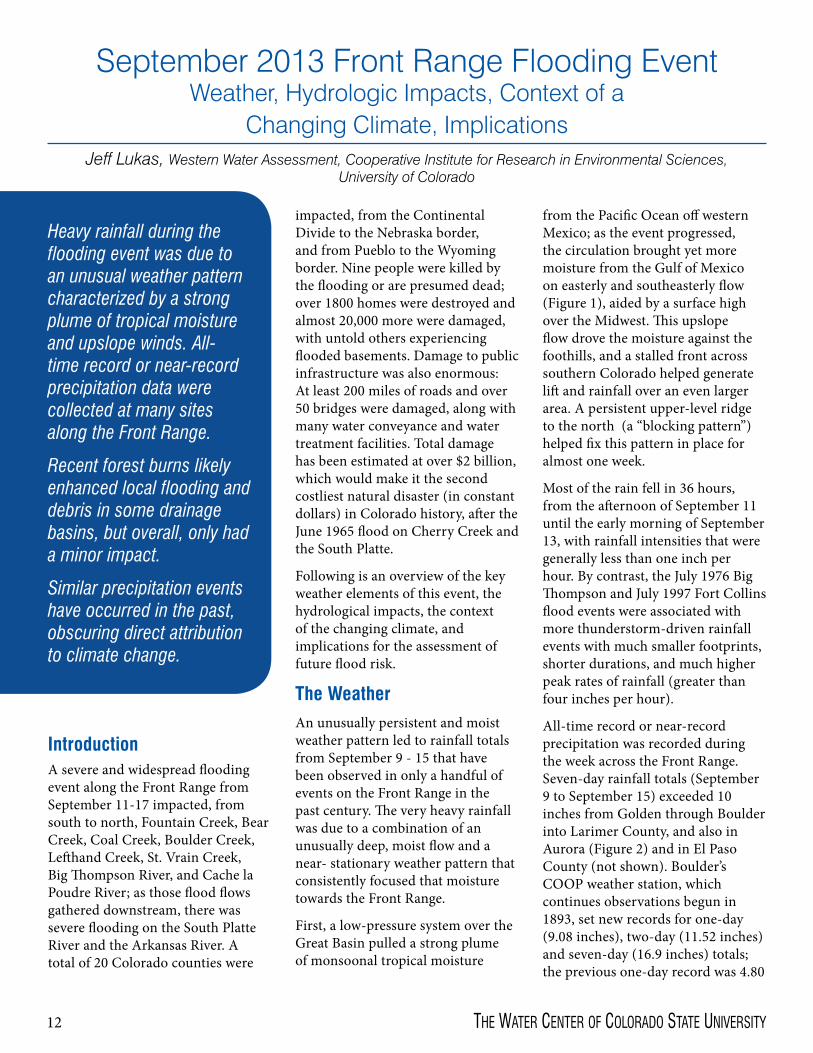
Heavy rainfall during the flooding event was due to an unusual weather pattern characterized by a strong plume of tropical moisture and upslope winds. All-time record or near-record precipitation data were collected at many sites along the Front Range.
Recent forest burns likely enhanced local flooding and debris in some drainage basins, but overall, only had a minor impact.
Similar precipitation events have occurred in the past, obscuring direct attribution to climate change.
IntroductionA severe and widespread flooding event along the Front Range from September 11-17 impacted, from south to north, Fountain Creek, Bear Creek, Coal Creek, Boulder Creek, Lefthand Creek, St. Vrain Creek, Big Thompson River, and Cache la Poudre River; as those flood flows gathered downstream, there was severe flooding on the South Platte River and the Arkansas River. A total of 20 Colorado counties were
impacted, from the Continental Divide to the Nebraska border, and from Pueblo to the Wyoming border. Nine people were killed by the flooding or are presumed dead; over 1800 homes were destroyed and almost 20,000 more were damaged, with untold others experiencing flooded basements. Damage to public infrastructure was also enormous: At least 200 miles of roads and over 50 bridges were damaged, along with many water conveyance and water treatment facilities. Total damage has been estimated at over $2 billion, which would make it the second costliest natural disaster (in constant dollars) in Colorado history, after the June 1965 flood on Cherry Creek and the South Platte.
Following is an overview of the key weather elements of this event, the hydrological impacts, the context of the changing climate, and implications for the assessment of future flood risk.
The WeatherAn unusually persistent and moist weather pattern led to rainfall totals from September 9 - 15 that have been observed in only a handful of events on the Front Range in the past century. The very heavy rainfall was due to a combination of an unusually deep, moist flow and a near- stationary weather pattern that consistently focused that moisture towards the Front Range.
First, a low-pressure system over the Great Basin pulled a strong plume of monsoonal tropical moisture
from the Pacific Ocean off western Mexico; as the event progressed, the circulation brought yet more moisture from the Gulf of Mexico on easterly and southeasterly flow (Figure 1), aided by a surface high over the Midwest. This upslope flow drove the moisture against the foothills, and a stalled front across southern Colorado helped generate lift and rainfall over an even larger area. A persistent upper-level ridge to the north (a “blocking pattern”) helped fix this pattern in place for almost one week.
Most of the rain fell in 36 hours, from the afternoon of September 11 until the early morning of September 13, with rainfall intensities that were generally less than one inch per hour. By contrast, the July 1976 Big Thompson and July 1997 Fort Collins flood events were associated with more thunderstorm-driven rainfall events with much smaller footprints, shorter durations, and much higher peak rates of rainfall (greater than four inches per hour).
All-time record or near-record precipitation was recorded during the week across the Front Range. Seven-day rainfall totals (September 9 to September 15) exceeded 10 inches from Golden through Boulder into Larimer County, and also in Aurora (Figure 2) and in El Paso County (not shown). Boulder’s COOP weather station, which continues observations begun in 1893, set new records for one-day (9.08 inches), two-day (11.52 inches) and seven-day (16.9 inches) totals; the previous one-day record was 4.80

13Colorado Water — November/deCember 2013
Gage 2013 Peak Height/Discharge (preliminary)
New all-time record?
Previous/current record Height/Discharge Comment
Fountain Creek near Fountain 10.1’; 15,300 cfs No 22,100 cfs, 5/28/1940Arkansas R. near Avondale 9.5’; 10,800 cfs No 50,000 cfs, 6/18/1965Bear Creek at Morrison 9.1’ No? 9.2’, 9/1/1938Boulder Creek at Boulder 8.2’, 5,000 cfs No ~9,000-13,600 cfs,
5/30/18941894 estimated
St. Vrain Creek at Lyons >8.8’ Yes? 8.1’, 10,500 cfs, 6/22/1941
Gage destroyed 2013
N. Fork Big Thompson R., Drake 10.2’ Yes 9.3’, 7/31/1976Big Thompson R., Canyon Mouth
>8.2’ No? ~19.9’, ~31,000 cfs, 7/31/1976
Gage destroyed 2013 and 1976
Poudre R. at Ft. Collins 10.8’, 8,420 cfs Yes? 10.5’, 7,710 cfs, 4/30/1999
Gaged since 1975
S. Platte R. near Fort Morgan 24.7’, 50,600 cfs No 83,700 cfs, 5/31/1935
Figure 1. Deep plumes of moisture (blue, white, and green) are drawn towards the Front Range from the Pacific and the Gulf of Mexico by the circulation around an upper-level low (L) over the Great Basin and a low-level high to the east, at 11:15 pm MDT on September 11, 2013, during the peak rainfall intensity in Boulder. Drier air is shown in yellow.
Satellite image courtesy of CIMSS, University of Wisconsin; annotations by Jeff Lukas, WWA
Figure 2. Total precipitation from September 9 through September 15, 2013, showing large areas with over 10 inches of rain, and the maximum values of 17 inches around Boulder and in northwest Boulder County. Representative totals for selected locations are shown.
Data and map courtesy of Colorado Climate Center
Table 1. Preliminary flood peaks from selected gages on Front Range drainages affected by flooding, September 2013, compared with previously recorded or estimated flood peaks. Data from USGS, Colorado DWR, UDFCD

14 the Water CeNter of Colorado State UNiverSity
inches, and the previous one-month record was 9.59 inches. New one-day, two-day, and seven-day benchmarks were set at many other COOP stations with shorter records and also at high-elevation SNOTEL sites; heavy precipitation fell as rain all the way to the Continental Divide,
which was unusual for a storm at this time of year. The same event also generated one-week rainfall totals over five inches in east-central and southwestern Colorado and across much of New Mexico.
In the context of the entire Front Range, this was a rare precipitation event, especially for September, and in some respects it was unprecedented in the observed record. But there have been previous multi-day rainfall events on the Front Range with similar
Figure 3. Hourly rainfall intensity at
the Sugarloaf RAWS station six miles west of Boulder compared with gage height on Boulder Creek at Boulder (west
of Broadway). The first flood peak closely
followed the heavy rainfall before midnight on 9/11-12, when 3.5”
fell in six hours. Rainfall data courtesy of RAWS via Western
Regional Climate Center; streamflow data courtesy
of Colorado Dept. of Water Resources, plotted by Jeff
Lukas, WWA
Figure 4. The range of total atmospheric
precipitable water (PW) over Denver by
month from 1948-2012, as measured
by balloon soundings. The measurement on September 11, 2013 (red dot) was higher
(more moist) than any previous September
reading. The prominent seasonal curve reflects that warmer air is able to contain more water
vapor. Adapted from NOAA
National Weather Service

15Colorado Water — November/deCember 2013
spatial extents and maximum total precipitation: September 1938 (10 inches max), June 1965 (16 inches max), and May 1969 (14 inches max). The footprints of the 1938 and 1969 events were most similar to 2013, while the June 1965 event was focused further south, between Denver and Pueblo.
It has also been widely reported that this was a “1000-year rainfall” for Boulder based on NOAA’s Atlas 14 precipitation frequency analysis; however, this analysis extrapolates from the historical record using statistical assumptions that have acknowledged large uncertainties for very rare events. It is also important to note that this analysis provides frequency estimates for a given point (e.g., Boulder); if we expand our spatial perspective to an area, any given extreme observed value occurs more frequently.
The Hydrologic ImpactThe very heavy rains caused severe to extreme flooding across the northern Front Range, in portions of the southern Front Range, and in downstream areas in eastern Colorado. In some drainages, the peak flow appears to have been higher than the previous record peak height or discharge from the past 35 to 80 years (see Table 1). While systematic determinations of peak flood discharges have yet to be made by USGS and others, it appears likely that this was a 100-year flood (or more accurately: a one-percent-probability-per-year flood) in some of the affected drainages, but not in others. The 2013 data shown in Table 1 is preliminary, and comparisons with past flood events are complicated by physical changes in the upstream basin and its management (e.g., dam releases), changes in the stream channel around the gage, and the challenges
of obtaining accurate measurements when a stream is in flood and beyond bankfull.
Taken as a whole, the 2013 event does not appear to be unprecedented for the Front Range in hydrologic terms. Floods in May 1935 and June 1965 were as widespread as in 2013 and by some measures had greater magnitudes (e.g., discharge per unit area), but these events were focused to the south of the 2013 event. The September 1938 flood event had a similar north-south footprint, with similar peak flows in several drainages, and it occurred at the same time of year. The May 1969 floods also had a similar north-south footprint, but peak flows in most drainages were lower than in 2013. The July 1976 Big Thompson and July 1997 Fort Collins floods had extreme peak runoff in the affected drainages, but these floods affected a much smaller area.
Because the peak rainfall intensities (inches per hour) were generally lower than in previous Front Range floods (Figure 3), the peak flows in the 2013 event may have been lower than one would expect from the very high precipitation amounts, though the flood flows in 2013 were sustained for a longer duration than in previous floods.
Many have wondered if the flooding severity was linked to recent Front Range wildfires. The preliminary consensus of experts on post-fire hydrologic change at CSU and USGS is that recent moderate- to high-severity burns clearly enhanced local flooding (and debris flows) in some drainages, such as Fourmile Creek west of Boulder, and some tributaries of the Poudre River, but likely had only a minor impact on the flooding overall. Debris flows also occurred in areas that had not experienced recent burns.
The Changing ClimateBecause human changes to the atmosphere have made the weather-climate system warmer and moister, one can reasonably say that all weather systems are now under the influence of climate change. The most plausible influence of climate change is that slightly more water vapor was likely made available for precipitation. Below, three aspects of potential climate change influence are discussed.
Water Vapor
Warmer air can contain more moisture; it is believed that human-caused warming has caused about a three to five percent increase in atmospheric water vapor on a global basis. By extension, this effect may have been responsible for a relatively small increase in the water vapor in the moisture plumes that fed the Front Range event. Total moisture content of the atmosphere above Denver on September 11 was observed to be at record levels for September (Figure 4); this mainly reflects the effectiveness of the weather pattern in funneling moist flow to the Front Range, though may also reflect a climate change contribution.
Trends in Heavy Rainfall Events
No increasing trend has been observed in the past century in very heavy rainfall (extreme one-day and five-day events) in the southwestern U.S. (including Colorado), unlike other regions of the U.S. and the world; however, a different metric of heavy precipitation (as a proportion of annual precipitation) shows a small upward trend for this region. Heavy rainfall events are projected to increase in frequency in the future over many parts of the globe, but the projected trends for Colorado are less certain.

16 the Water CeNter of Colorado State UNiverSity
The Unusual Weather Pattern
As described earlier, the extraordinary rainfall in this event was due mainly to the unusual and persistent weather pattern that funneled abundant moisture towards the Front Range and enhanced the lift. This atmospheric circulation in the 2013 event was very similar to that in the September 1938 event,
both the upper-level pattern and the surface pattern. Thus, one can say the atmospheric setup for the 2013 event was rare but not unprecedented, and climate change does not need to be invoked to explain the pattern itself. It has been hypothesized that slow-moving weather systems like in the 2013 event may become more common under climate change due
to changes in the jet stream, but the evidence for this is very uncertain.
Climate researchers at CIRES, NOAA, CSU, and elsewhere will systematically address the climate change “attribution” of this event, through analysis of observations, historical trends, and climate model experiments. In doing so, they will also try to discern whether the risk of similar events occurring will change in the future.
Front Range Flooding Risk in Light of 2013Flood risk is the product of a natural hazard (likelihood of climatic and hydrologic extremes) and the societal exposure and sensitivity
Figure 6. The U.S. Drought Monitor showing the drought extent and severity for Colorado before and after the rain event and flooding of September 2013. Most of the state saw improvement by one to three categories. Courtesy of National Drought Mitigation Center, University of Nebraska-Lincoln
Figure 5. Railroad tracks hanging over the washed-out bed along South Boulder Creek near present-day Highway 93 near Marshall, after the September 1-3, 1938 flood. The gaged peak discharge in the 1938 flood (7,390 cfs) was much higher than that of September 2013, though the latter was influenced by floodwater retention in Gross Reservoir.
Photo courtesy of the Urban Drainage and Flood Control District

17Colorado Water — November/deCember 2013
Additional Resources• The September 2013 Front
Range Floods: http://cires.colorado.edu/blogs/flood
• Boulder Area Flood of September 2013: Climate and Weather Info: http://www.esrl.noaa.gov/psd/boulder/flood2013
• Historic Rainfall and Floods in Colorado – climate.gov, NOAA http://www.climate.gov/news-features/event-tracker/historic-rainfall-and-floods-colorado
• Colorado Flood 2013 - Colorado Climate Center, CSU http://COFlood2013.colostate.edu
• Inside the Colorado Deluge – UCAR/NCAR AtmosNews http://www2.ucar.edu/atmosnews/opinion/10250/inside-colorado-deluge
• Western Water Assessment: http://wwa.colorado.edu
• CIRES: http://cires.colorado.edu
• NOAA: http://www.noaa.gov
• Colorado Climate Center: http://ccc.atmos.colostate.edu
(homes, infrastructure, and other assets in the path of flooding). The September 2013 event tells us that the natural hazard of flooding for the Front Range includes not just smaller-scale convective events with very high rainfall intensity (e.g., Big Thompson, July 1976), but also rain-on-deep-snowpack events (May 1894), and broader-scale, long-duration rain events with mainly lower intensities like in 2013.
We need to be cautious when interpreting estimates of the likelihood of rare events; it is difficult to make reliable assessments given the relatively short observed record. We should also recognize that the likelihood or return interval of a flood is not necessarily identical to the likelihood or return interval of the precipitation event associated with the flooding; additional factors besides total precipitation affect flood magnitude.
Given the very clear historical record of similar past events, such as September 1938 (Figure 5), an event of the magnitude of September 2013 could occur again even in the absence of climate change. It’s clear that total societal exposure to flooding on the Front Range has increased in the past several decades due to population growth and development. Without widespread mitigation of existing exposure and avoidance of new exposure, we can expect a recurrence of a 1938/2013-type flood hazard to cause even more damage in the future.
The Silver Lining: Drought ReliefAs destructive as this rain event was, it also had a beneficial side: ameliorating or eliminating the persistent drought conditions in the flood-impacted area and beyond. The U.S. Drought Monitor before
and after the event indicates that a large area of D0 (abnormally dry) to D2 (severe drought) has along the Front Range recovered completely to non-drought status, while drought conditions across most of the rest of Colorado experienced improvement by at least one category (Figure 6). Front Range reservoirs that were in their typical fall-winter drawdown refilled within days. Even giant Lake Powell benefited, gaining about 200,000 acre-feet of storage during a three-week period when it normally would have declined over 100,000 acre-feet. The widespread heavy precipitation also greatly reduced late-season residential and agricultural irrigation demand, and left saturated soils just ahead of the winter freeze-up and snowpack accumulation, paving the way for more efficient runoff next spring.
Note: This article is adapted from the briefing document “Severe Flooding on the Colorado Front Range, September 2013: A Preliminary Assessment,” developed by the Cooperative Institute for Research in Environmental Sciences (CIRES) Western Water Assessment at the University of Colorado, with the NOAA ESRL Physical Science Division and the Colorado Climate Center at Colorado State University, and released on September 25, 2013. The author acknowledges the following people who contributed to that assessment: Klaus Wolter, Kelly Mahoney, and Joe Barsugli (CIRES/NOAA PSD); Nolan Doesken and Wendy Ryan (CCC/CSU); Imtiaz Rangwala, Ben Livneh, and Eric Gordon (CIRES/WWA); Martin Hoerling and George Kiladis (NOAA PSD); Ami Nacu-Schmidt (CIRES/CSTPR).
18 the Water CeNter of Colorado State UNiverSity
The Soil, Water, and Plant Testing Laboratory at Colorado State University
James Self, Director, Soil, Water, and Plant Testing Laboratory
CSU’s Soil, Water, and Plant Testing Laboratory analyzes samples from local sources, as well as national and international samples. Clients vary, and include both individuals, such as homeowners, and larger groups, such federal entities.
In addition to providing analytical results to its customers, the lab also answers questions and helps determine what may be done to treat problematic water.
The lab is also actively involved in research, such as developing new analysis methods.
The Soil, Water, and Plant Testing Laboratory at Colorado State University was established in
1964 through an agreement with the United States Department of Agriculture. It was originally in the old Vocational Education Building until it was moved to the Natural and Environmental Sciences Building (NESB) in 1995. It is currently on the third floor of the NESB in room A319 and is administered by the Department of Soil and Crop Sciences. It is self-sufficient in that it relies on fees received for lab services. The lab provides analytical services primarily in the following areas:
• Nutrient analysis of soil to provide fertilizer recommendations using both chemical and organic fertilizers
• Salt evaluation in soil and water to remediate salt affected soils and to better manage irrigation water
• Heavy metal analysis in soil, water, and plant tissue for elements such as lead, cadmium, nickel, mercury, etc. that may accumulate from industrial activity or mining operations
• Water analysis for parameters such as pH, electrical conductivity, calcium, magnesium, sodium, nitrates, sulfate, etc. to evaluate water quality in well and surface water with respect to domestic, irrigation, and livestock use
• Water analysis for parameters such as total organic carbon, total nitrogen, tannins, cyanide, dissolved oxygen, and corrosivity to evaluate water quality in disturbed or industrial areas and to help solve plumbing or water treatment problems
• Plant analysis including:
- Nutrient levels to evaluate deficiencies and poor plant growth
- Fiber levels, protein, and minerals to evaluate forage quality and establish relative feed value
- Selenium, cyanide (prussic acid), and nitrates to help livestock producers manage potentially poisonous forage products
• Analysis of composts, biosolids, and other soil amendments for use in reclamation, garden, landscape and marketing purposes
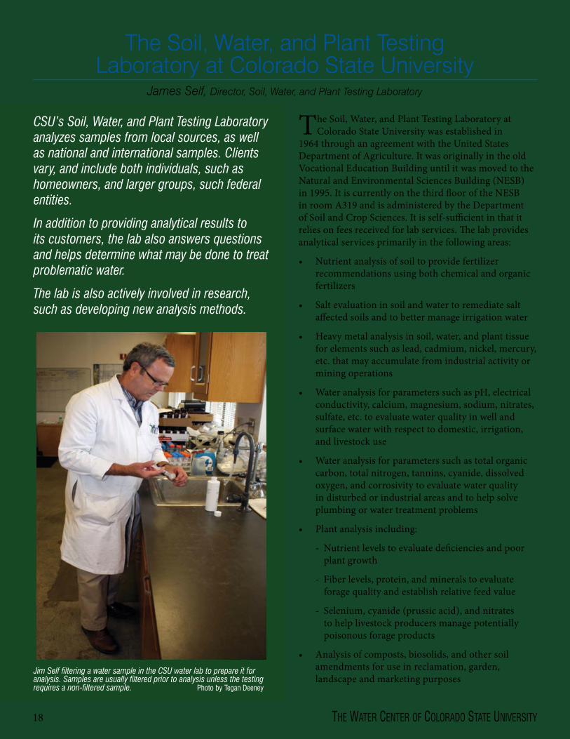
Jim Self filtering a water sample in the CSU water lab to prepare it for analysis. Samples are usually filtered prior to analysis unless the testing requires a non-filtered sample. Photo by Tegan Deeney
19Colorado Water — November/deCember 2013
The laboratory receives samples from the general public nationwide and from around the world. It possesses a soil and plant import permit from the United States Animal and Plant Health Inspection Service (APHIS) that allows it to receive soil and plant samples from overseas and from restricted areas of the United States. The laboratory’s clients range from homeowners, ranchers, and farmers to environmental consultants, local governments, federal agencies, foreign and domestic researchers, and foreign aid agencies. The lab also aids graduate and undergraduate students at CSU as well as students nationwide with research problems related to lab analysis. Students at CSU are allowed to use the lab to complete their theses or dissertations at a modest cost. An important component of the lab’s service is its relation to Extension, since Extension personnel frequently make use of the lab’s capabilities to provide answers to their clients’ inquiries. Since university soil and water labs have closed in Arizona, New Mexico, Wyoming, Nebraska, and South Dakota, the Soil, Water, and Plant Testing Lab at Colorado State University has been working with Extension offices in those states to inform their clients about lab testing at CSU.
Since the mid 1960s, the laboratory has also been actively involved with research. The lab’s early director, Hunter Follett, was instrumental in establishing the groundwork for much of the fertilizer recommendations that are
used today. Another soil scientist, Parviz Soltanpour, developed an extraction reagent for soils in 1977 called ammonium bicarbonate-DTPA that was found to extract nitrates, phosphorus, potassium, zinc, iron, manganese, and copper in alkaline soils simultaneously without having to extract each of those components separately. Also in the late 1970s and early 1980s, Soltanpour and Steve Workman, the lab’s manager until 1988, developed methods for the analysis of selenium from soil using the ammonium bicarbonate-DTPA extract. In the 1990s, Juan Rodriguez and James Self established the acid stability plateau for phosphorus analysis that determined the optimum pH needed to assure accurate phosphorus analysis. Other methods such as the Walkely-Black Method for soil organic matter were successfully modified to make their use faster and to minimize the use of potentially toxic chemicals.
Once the lab has analyzed a client’s samples, it prints out a report listing the analytical parameters and the values for each parameter. In the water reports there will be comments about whether the values for the parameters exceed Environmental Protection Agency (EPA) limits. Once the client receives the report, he or she can contact the lab with questions. The lab will aid clients with interpreting lab results and determine what they can do to help treat the water if there are problems with it. About half of the water samples received by the lab have
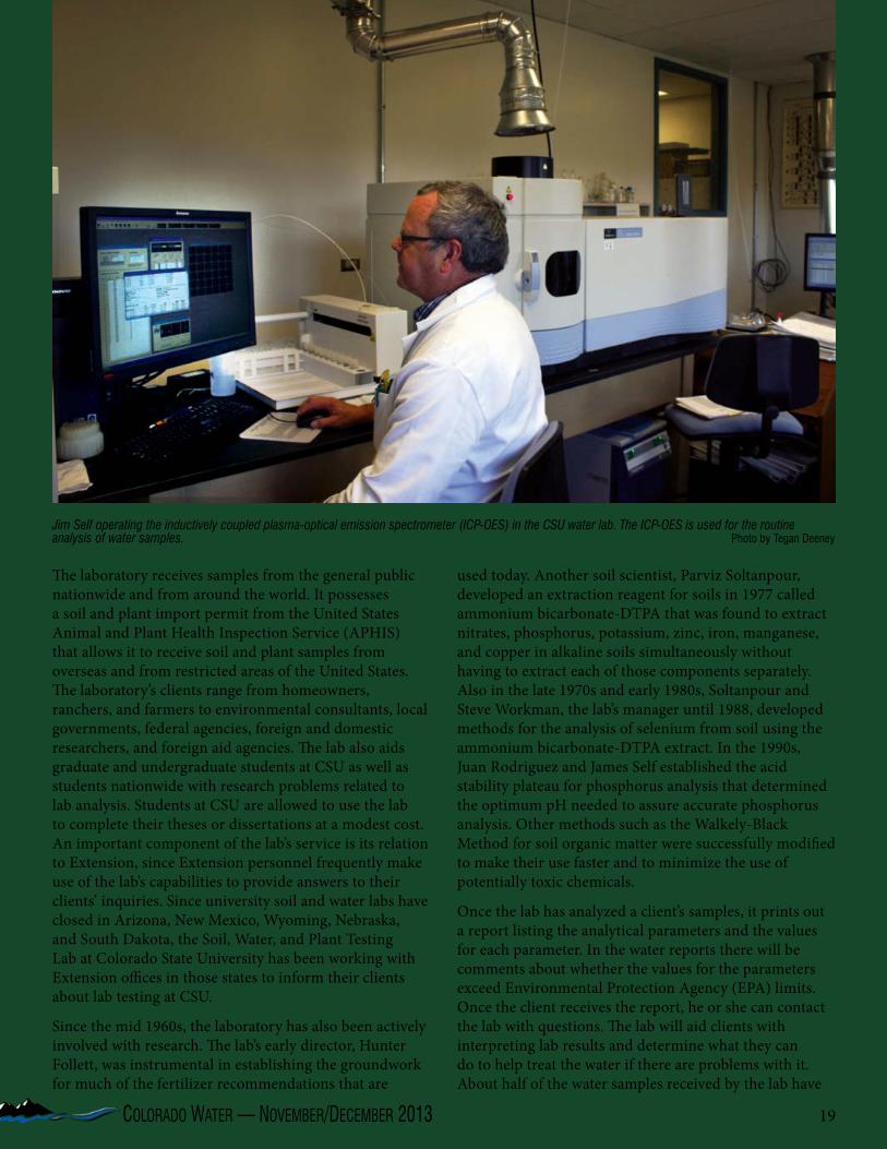
Jim Self operating the inductively coupled plasma-optical emission spectrometer (ICP-OES) in the CSU water lab. The ICP-OES is used for the routine analysis of water samples. Photo by Tegan Deeney
20 the Water CeNter of Colorado State UNiverSity
a high electrical conductivity (EC) greater than 1200 uS/cm or total dissolved solids (TDS) greater than 840 mg/L. These samples originate primarily from wells or surface water along the front range and further east or from the western slope. Water samples from mountain areas greater than 6,000 feet can vary greatly, but usually have a range of electrical conductivities of 20-30 uS/cm from high elevation mountain lakes and streams (greater than 10,000 feet) to 300 uS/cm from lower elevation wells at 6,000 to 7,000 feet.
While it is not common for water samples to have excessively high levels of heavy metals, they can occur in facilities with older plumbing, or from being in close proximity to industrial activities or mining operations. Usually, higher metal levels seem to originate from the corrosion of copper, iron, aluminum, or galvanized piping. In some cases mountain well or surface water has been impacted with heavy metals such as zinc, cadmium, or lead by abandoned mines that are upstream from a well. Old gold mine locations can also be a source of mercury if they are upstream from a water source. However, this has not been found to be very common.
A common question is, “How can the water be treated to make it usable for domestic, livestock, or irrigation use?” For domestic use, the response usually involves recommending simple purification products such as carbon or spun fiber, 5 um filters to whole house reverse osmosis systems. Most producers managing livestock with poor quality water usually have to truck in water to isolated water tanks. Treating the water with reverse osmosis or ion exchange systems has been used for horses or registered purebred cattle. Dealing with poor quality irrigation water can be difficult, since water can be high in electrical conductivity or TDS and can be high in sodium, as well. This can result in sodium adsorption ratios (SAR) greater than 6-10. Irrigation water with high ECs and high SARs may rule out the use of the water for plant growth, since the sodium can accumulate to raise the SAR of the soil creating poor drainage and salt damage in plants.
Customers will use lab services when the quality of their water is compromised and they need to decide what to do to get their water analyzed. Establishing what should be examined in a water sample is the single most asked question. To decide what has to be analyzed, determine if there is a problem to begin with such as the presence of odors, discoloration, corroding pipes, inadequate plant growth, or livestock refusing to drink the water. Odors are usually from sulfides; discoloration can be due to high iron (red or yellow), copper (blue), or manganese (brown or black); and poor plant growth can be due to high EC or
excessive sodium. In most cases a water “routine” test can cover the needed analysis requirements. A routine test can be comprised of pH, EC, calcium, magnesium, sodium, sulfate nitrate, alkalinity, hardness, etc. Additional testing for metals can be done if there is discoloration in the sample. Some tests such as those conducted to detect the cause of odors will require more extensive analysis, and the lab should be contacted to decide which procedures are necessary.
For questions related to lab analysis, contact James Self or Debbie Weddle at the Soil, Water, and Plant Testing Laboratory at 970-491-5061. Visit our website at www.soiltestinglab.colostate.edu for analysis forms and for links to other helpful resources. The lab is open from 8 a.m. to 5 p.m. Monday through Friday year round, and is closed for major holidays.
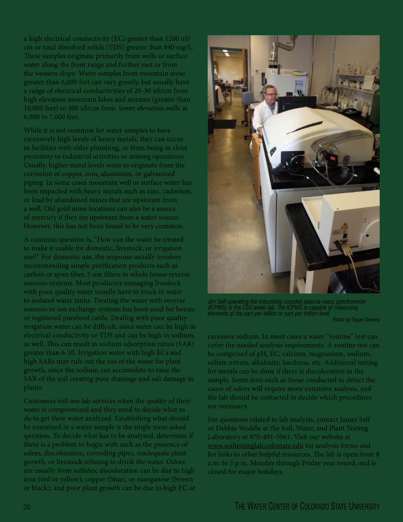
Jim Self operating the inductively coupled plasma-mass spectrometer (ICPMS) in the CSU water lab. The ICPMS is capable of measuring elements at the part per billion or part per trillion level.
Photo by Tegan Deeney

21Colorado Water — November/deCember 2013
Reinvigoration of CSU Water CenterLindsey Middleton, Editor, Colorado Water Institute
Faith Sternlieb, Research and Outreach Coordinator, CSU Water Center
The Colorado State University (CSU) Water Center’s roots
grew out of a collaborative and interdisciplinary endeavor between the Vice President of Research and the Colleges of Engineering and Natural Resources in 1994. Neil Grigg, Professor of Civil and Environmental Engineering, procured a three-year grant from the Colorado Commission on Higher Education to jump start the center with the goal of embracing engineering, natural resources, agriculture, Extension, and the Experiment Center. Since then, there have been two other Directors—Robert Ward (1998-2005) and Reagan Waskom (2005-2013). Since 1998, the CSU Water Center has been co-housed with the Colorado Water Institute.
During 2012 a faculty group led by Gene Kelly was charged with developing a new vision for the Water
Center. Provost Miranda responded to the report by developing new central funding for the first time since 1998. Miranda has charged a faculty group with developing a new or revitalized CSU Water Center with the aim to engage the CSU community in water resources research, education, and outreach.
This new funding will focus more specifically on the mission of the CSU Water Center, which is to catalyze excellence in water research, teaching, and engagement by fostering interdisciplinary collaboration and creative scholarship among CSU faculty and students. The goals and mission of the center may evolve as the center expands its scope. In contrast, the Colorado Water Institute’s mission is to focus the water expertise of all higher education in Colorado on the evolving water concerns and problems being faced by Colorado
citizens. The activities, funding, and management of each of these units will be complementary and distinct.
The Water Center will be faculty led, consisting of an executive committee that has been selected for the center, including 11 faculty members from various colleges and departments with Reagan Waskom, Colorado Water Institute Director, as the chair. The committee represents a broad range of water expertise across campus.
“It will take us some time to establish the new CSU Water Center and its role on campus,” says Waskom. “But we will be able to do so effectively with the support of faculty and the experience of the Executive Committee.”
Water is an important educational and research subject matter at CSU—22 of the university’s departments house over 140 water faculty, who teach
CSU faculty met at an open house to discuss the Water Center. Photo by Emilie Abbott

22 the Water CeNter of Colorado State UNiverSity
over 150 water-related courses. With its new distinction, the CSU Water Center will be able to better focus its efforts within this community.
In October, the CSU Water Center announced its first Request for Proposals to facilitate innovative research from individual faculty and faculty teams. The center received a round of proposals for 2013-2014 which exemplified “transformative water research, teaching, and engagement through interdisciplinary collaboration and creative scholarship among CSU faculty and students.” Proposal types included multi-disciplinary teams, multi-investigator teams, and water faculty fellows. These proposals are currently under review.
According to Chair of the Proposal Review Committee James Pritchett, “Submitted proposals displayed a vibrant, active water community at CSU. Proposals tapped expertise across disparate academic units by developing joint objectives that will result in impactful results and outreach to stakeholders. Proposals seek to answer pressing water questions to the local and regional community at the same time they build capacity for future collaborations.”
“We want to foster small grants that lead to big projects,” says Waskom. He hopes that the Water Center will foster many more new and innovative water-related initiatives, ranging from seed projects to newly created educational materials to invited speakers.
Another initial effort of the center will be to build a new Water Minor, housed under the School of Global Environmental Sustainability (SoGES). By fall semester of 2014, students from various disciplines will be able to pursue the new minor track.
CSU Water Center Executive CommitteeMazdak Arabi, Associate Professor, Department of Civil and Environmental Engineering, College of Engineering
Kurt Fausch, Professor, Department of Fish, Wildlife, and Conservation Biology, Warner College of Natural Resources
Brian Fugate, Associate Professor, Department of Management, College of Business
Stephanie Kampf, Associate Professor, Department of Ecosystem Science and Sustainability, Warner College of Natural Resources
Eugene Kelly, Department Head and Professor, Soil and Crop Sciences, College of Agricultural Sciences
Melinda Laituri, Professor, Department of Ecosystem Science and Sustainability, Warner College of Natural Resources
Leroy Poff, Professor, Department of Biology; Director, Graduate Degree Program in Ecology, College of Natural Sciences
James Pritchett, Professor, Associate Department Head, Department of Agriculture and Resource Economics, College of Agricultural Sciences
Jorge Ramirez, Professor, Department of Civil and Environmental Engineering, College of Engineering
Pete Taylor, Associate Professor, Department of Sociology, College of Liberal Arts
Reagan Waskom (chair), Director, Colorado Water Institute
Diana Wall, Director, School of Global Environmental Sustainability
Future initiatives include the development of a MOOC—a massive open online course— aimed at unlimited participation and open access. The first CSU MOOC was offered by CSU OnlinePlus in fall of 2013, entitled “Science of Relationships.” Another MOOC, “Water, People, and Nature—Addressing 21st Century Global Challenges,” is expected for 2014.
In addition to curriculum goals, future hires led by the Water Center will help bring the university to a nationally-recognized level in certain areas of water research. Some of these areas, for instance, may include ecohydrology, irrigation efficiency, or water for energy. The center also plans to become more involved in international water activity.
The Colorado Water newsletter will remain the same, but may become more faculty-based with a new feel. The Water Center website (watercenter.colostate.edu) is undergoing a redesign and will include new and improved CSU-centric information.
“We haven’t finished investing in the Water Center,” says Miranda. Future efforts will continue to establish the center as an important part of CSU’s educational, outreach, and research initiatives. He explains that the center should be a tool for faculty to more effectively and efficiently apply their own efforts—the new Water Center will be about building collaborations. “We need to hear from you,” he says.
The CSU Water Center will be located in 119 Johnson Hall, Colorado State University. Please call (970) 491-2695 or email Faith Sternlieb ([email protected]) or Reagan Waskom ([email protected]) with questions. Stay in the loop with CSU Water Center activities on Facebook!

23Colorado Water — November/deCember 2013
An Archival Collaboration to Benefit the Colorado Water Community
Patricia J. Rettig, Head Archivist, Water Resources Archive, Colorado State University Libraries
Many archival repositories across the state hold collections
documenting Colorado water issues. No repository holds more state-level collections, though, than the Colorado State Archives. With a recent change in leadership, the State Archives is now initiating a project to inventory its extensive collections containing water records and make them more accessible. As part of the project, State Archives staff recently reached out to the Water Resources Archive at Colorado State University to tap into our long-established expertise.
In May, I visited with archivist Erin McDanal in her basement cubicle at the Sherman Street Centennial Building. We began our conversation by discussing her plans for the water project she was beginning to implement. She has long had an interest in improving access to the state’s water records, and the new state archivist George Orlowski fully supports the project.
Since 1943, the Colorado State Archives has had a mandate to preserve the historical records of the legislature, state agencies, local governments, and special districts. Over the decades, it has accumulated over 100,000 cubic feet of permanent records. At this point, it is not known how many of those records document water court cases, relevant legislation, the State Engineer’s Office, or other related state water issues and agencies, but the plan is to find out!
“Realizing the vital historical and legal importance of water records in the arid west,” Erin said, “we are embarking on this project to inventory and create quality finding aids for most of the records in
our custody concerning water.” These records are voluminous and significant. Included will be records long held by the State Archives from agencies such as the Division of Water Resources, the Colorado Water Conservation Board, and others that create records related to adjudication, water pollution, parks, and recreation.
Identifying agency records will be a large part of the project, but that may be the easiest of the many challenges involved. Erin and the interns she hopes to hire will also sift through governors’ records to find water-related files, correspondence, reports related to water legislation, compacts, and court cases. These materials will be inventoried for online finding aids and eventually digitized for online access.
In addition to paper-based primary source materials from the executive branch, audio tapes of legislative committee hearings and floor debates from 1973 to the present exist at the State Archives. Researchers can discover the legislative intent of bills and listen to discussions regarding their passage or why a bill failed.
The recordings are accompanied by meeting summaries and any attachments distributed to legislators. Because these fragile media could contain content not captured elsewhere, these recordings are a priority not only for inventorying but also for digital migration.
Perhaps the greatest challenge of the water project is taming the multitudinous agglomeration of records from the judicial branch. The State Archives has custody of records from water courts, county courts, the Court of Appeals, and the Supreme Court, all of which by default have water-related records. However, the cases are stored by case number, and a comprehensive index has never been compiled, so determining which dockets concern water will be a major undertaking. The eventual goal, as time and funding permit, is to create a website with finding aids to the entire collection and then to scan and make important historical water cases available on the Internet.
As all of this happens, connections between records at the two repositories will become more apparent than they already are. The Water Resources Archive holds personal papers of individuals active at the state level, including Delph Carpenter, Ival Goslin, and Justice Greg Hobbs. Records at the State Archives documenting their work—on compacts, legislation, water supply, litigation, and more—will surely be brought to light. Additionally, various court case files involving ditch companies or groundwater issues will complement numerous collections in our holdings.
During my initial conversation with Erin, this possibility that emerged
President Harry S. Truman signing bill granting congressional consent to Upper Colorado River Basin Compact, April 6, 1949. Collections documenting river compacts are just one example of how closely related the State Archives and the Water Resources Archive are.
Courtesy of the Colorado State Archives

of a fuller and more easily accessible understanding of the state’s water history excited me. In full support of the State Archives’ goals, I began connecting Erin with leaders at various water agencies and in the judicial branch. I also connected her with other water leaders who may have interest in the project, have students to serve as interns, or can lend support. Erin has started giving tours for some of these folks and begun generating a great deal of interest.
Another aspect of improved access at the State Archives involves state archivist George Orlowski, a member of the new statewide digital task force. Via this task force, state agencies, the legislature, and the judicial branch—partnering for what is believed to be the first time—will develop statewide standards to digitize analog materials
and organize born-digital records on the front end. Water records will be a large part of this endeavor. The final product will be a one-stop web location where researchers can locate records from all over the state and access a growing number of them online.
Researchers, including historians, attorneys, state agency employees, and the entire water community, will benefit from all these efforts. This is why the collaboration between the CSU Water Resources Archive and the Colorado State Archives will be ongoing. The more each repository can preserve, provide inventories of, and digitize records, the more we all can learn about our state’s most precious resource.
For more information about the collections in the Water Resources Archive, see the website
(http://lib.colostate.edu/water/) or contact me (970-491-1939; [email protected]) at any time. For more information about the Colorado State Archives and its new water project, contact Erin McDanal (303-866-4893; [email protected]).
Colorado’s September 2013 floods were unmistakably historic. At CSU’s Water Resources Archive, we know that people will be interested in studying this event in the future. If you or someone you know has created flood documentation—photographs, videos, data, reports, personal stories—please consider depositing it with us. If you are conducting your own study of the event, please keep us in mind as a repository for your work upon completion.

25Colorado Water — November/deCember 2013
Irrigation Pumping AssessmentsCary Weiner, Clean Energy Specialist, Colorado State University Extension
Although irrigation pumping energy may not always be at the forefront of agricultural producers’ minds, it is one
of the costs a producer has at least some control over. While there is not much a producer can do about seed prices or commodity prices, there are often actions that can be taken to control how much is spent on energy for pumping water. To this end, Colorado State University’s Center for Agricultural Energy is offering reduced-cost irrigation pumping assessments for agricultural producers with center pivot sprinklers on the Front Range and Eastern Plains.
The purpose of an assessment is to determine how efficiently a pumping system is operating and to make recommendations for improving efficiency when possible. An assessment typically consists of a site visit lasting a few hours to an entire day depending on the number and complexity of pumping systems. For each pump to be assessed, a CSU engineer and students will determine the static water level, pumping water level, flow rate, and mechanical and electrical energy used for pumping under normal conditions. The assessment may confirm what a producer suspects are inefficiencies in the system or may uncover inefficiencies previously not known or understood. In some cases, the assessments will simply provide assurance that the pumping plants are operating optimally. The landowner is encouraged (but not required) to accompany the assessment team to each pump before the assessment begins as he/she can often provide useful background information about the pumping plant or irrigation system. The assessment team will analyze as many pumps as they are able to cover in one day—typically four to six.
After the site visit, a follow up phone call with the producer takes place in order to discuss preliminary findings. A written assessment report is later provided to the producer. This report will contain the background information used to calculate mechanical and electrical efficiencies as well as recommendations to improve those efficiencies if the pumping plants are not operating optimally. In the assessments we’ve completed so far, we are finding that pumping efficiencies and associated recommendations can vary widely. Recommendations have included replacing piping, replacing motors, and using variable frequency drives (where irrigation needs for crops fed by a single pump differ throughout the season). Each recommendation contains estimates of energy and financial savings, although if there are still unknowns after the assessment is conducted, these will be noted as well. Since financial savings are best estimated based both on historical energy use and potential energy savings, we may request
The Platte River Basin between Platteville and Sterling, Colorado.
Photo by Bill Cotton

26 the Water CeNter of Colorado State UNiverSity
a copy of previous utility bills. All information provided during the entire course of the assessment process and the report itself is kept confidential.
One of the benefits of these particular assessments is that CSU has no financial interest in whether or not our recommendations are implemented—we do not benefit from the producer taking action as a result of our assessment. On the other hand, if a producer does want to implement one or more of the assessment recommendations, we can assist that producer in a few ways. We have partnered with the International Center for Appropriate and Sustainable Technology (iCAST) to offer consulting and financing for implementing the assessment recommendations. If any financing is provided, the goal would be to establish payments that would be less than what is expected to be saved from the project. We can also point producers to local utility rebates (as applicable) and a number of other grant and loan opportunities for
implementing recommendations. In fact, assessments like ours are required before being able to receive USDA grant funds that could offset 25 percent of project costs. In addition, we are able to train a number of CSU engineering students with on-the-ground skills they could apply in either an urban or rural workforce in the future.
Through funding from USDA, we have been able to reduce the cost of these assessments from $1,000 to $250 per producer (which again will cover as many pumps as we can visit in one day). In addition to paying the fee, a producer must verify that over half of his/her gross income comes from agricultural production and that the operation is owned by U.S. citizens or permanent residents. There is a very brief “application” that requests some basic information about up to three pumping plants so that the assessment team can prepare properly for the site visit. The application can be found online at www.ext.colostate.edu/cae/audits.html or can be requested in
paper form by contacting Cary Weiner at (970) 491-3784 or [email protected].
CSU’s Center for Agricultural Energy has also recently released an online Do-It-Yourself Agricultural Energy Audit and has established a Web page that provides step-by-step guidance for applying for funds for agricultural energy projects through USDA. Producers can use online wind, solar, and anaerobic digestion decision tools to determine if they are good candidates for those technologies and, if so, can determine the estimated costs and savings they might expect from installing them. We also have numerous fact sheets and videos that producers can access through our website. The mission of the Center for Agricultural Energy is to improve the financial positions of agricultural producers and rural Colorado communities while providing solutions to 21st century energy problems. More information about the Center can be found at www.cae.colostate.edu.
Center for Agricultural Energy Co-Director Mike Kostrzewa, P.E., and graduate student conduct an irrigation pumping assessment in northeastern Colorado. Photo by Cary Weiner

27Colorado Water — November/deCember 2013
ARCADIS Contributes to a CSU Water
Research CenterLindsey Middleton, Editor, Colorado Water Institute
Since the 1990s, Colorado State University (CSU) has housed the Center for Contaminant Hydrology,
which specializes in researching contaminated soils and groundwater, the remediation of such issues, and educating students in addressing future environmental issues.
“Many environmental engineering students will go into consulting” and similar positions, says the center’s director Tom Sale, and it is important they be prepared for challenges that will arise in such endeavors.
Sale says several industry partners contribute to the funding of this center, including Chevron, DuPont Suncor Energy, ExxonMobil, and others.
In 2013, ARCADIS, an engineering firm based in Highlands Ranch, Colorado, donated $200,000 to the center. Gifts like these are “really unheard of,” says Sale. “This remarkable donation,” he says, “will contribute to forwarding research, collaboration, and education on innovative topics.”
Sale points out the importance of such funding—industries benefit in the form of student researchers, who will become well-educated industry leaders, and the center benefits from partnerships that lead to patents and innovative technology development. As schools and universities struggle to find funding, this strategy may become more important in continuing a strong research and education ethic within the academic setting.
ARCADIS has long been a significant partner of the center, and has adopted technologies created by center researchers. “We need early adopters,” says Sale—they enable the flow of new ideas and technologies.
The ARCADIS funds are considered an “unrestricted grant,” meaning that the center, dubbed the “ARCADIS Center for Excellence in Remediation Hydrology,” may use the funds as they see fit. Sale says the money will mainly support students and staff. He also emphasizes the importance of a continued partnership with ARCADIS. “Their ideas are important to us,” he says. The center will collaborate with ARCADIS’s Fred Payne (affiliate faculty).
The grant will also support an annual Steven Blake Lecture on Water Resources, which will highlight the work of select scientists that have contributed to research in water resources. Included in this year’s talk, which took place on October 23, were an introduction by former governor Bill Ritter and a featured talk by John Cherry, renowned for his
work in groundwater science. Blake is a CSU graduate, and was until recently the ARCADIS CEO.
The new center will focus on field-focused research relating to emerging challenges in the field of groundwater relating to water quality and supply. The overarching vision is to develop innovative solution to emerging problems and to provide world class education to the next generation of groundwater scientist and engineers.
The center includes 30 people, mainly research scientists and administrative professionals, with faculty leadership. They collaborate within CSU; with the University Consortium for Field Focused Groundwater Contamination Research, a group of similar research centers in Canada and the U.S.; and with important university and industry partners, including the University of Guelph in Ontario. Within CSU, Sale says many faculty members are important collaborators, including Charles Shackelford, Susan DeLong, Mike Ronayne, Thomas Borch, David Dandy, and others.
Courtesy of the Center for Contaminant Hydrology
Courtesy of the Center for Contaminant Hydrology

The CSU center funds 23 students currently, both graduate and undergraduate. Students are funded after the center goes through a process to identify critical opportunities in research. Some examples of such areas are the assimilative capacity of aquifers for contamination and subsurface water storage. The center always strives to focus on innovation, approaching new research areas and developing a solid research base and solutions.
Collaboration with ARCADIS will add to this work. ARCADIS is a 125-year-old company, whose focus is global engineering and consulting. CSU’s give-and-take with this company has included CSU’s use of the company’s textbook Remediation Hydrology and career opportunities for CSU graduates.
More information about the Center for Contamination Hydrology can be found at http://www.engr.colostate.edu/CCH/index.shtml.
Appraising options to reduce shallow groundwater tables and enhance flow conditions over regional scales in an irrigated alluvial aquifer system; Morway, Eric D.; Gates, Timothy K.; Niswonger, Richard G.
Optical techniques for the determination of nitrate in environmental waters: Guidelines for instrument selection, operation, deployment, maintenance, quality assurance, and data reporting; Pellerin, Brian A.; Bergamaschi, Brian A.; Downing, Bryan D.; Saraceno, John Franco; Garrett, Jessica D.; Olsen, Lisa D.
The quality of our Nation’s waters--ecological health in the Nations streams, 1993-2005; Carlisle, Daren M.; Meador, Michael R.; Short, Terry M.; Tate, Cathy M.; Gurtz, Martin E.; Bryant, Wade L.; Falcone, James A.; Woodside, Michael D.
Advective transport observations with MODPATH-OBS--documentation of the MODPATH observation process; Hanson, R. T.; Kauffman, L. K.; Hill, M. C.; Dickinson, J. E.; Mehl, S. W.
Discharges of produced waters from oil and gas extraction via wastewater treatment plants are sources of disinfection by-products to receiving streams; Hladik, Michelle L.; Focazio, Michael J.; Engle, Mark
Effects of surface applications of biosolids on groundwater quality and trace-element concentrations in crops near Deer Trail, Colorado, 2004-2010; Yager, Tracy J.B.; Crock, James G.; Smith, David B.; Furlong, Edward T.; Hageman, Philip L.; Foreman, William T.; Gray, James L.; ReVello, Rhiannon C.
Analysis of long-term trends (1950–2009) in precipitation, runoff and runoff coefficient in major urban watersheds in the United States; Velpuri, N. M.; Senay, G. B.
Simulated effects of proposed Arkansas Valley Conduit on hydrodynamics and water quality for projected demands through 2070, Pueblo Reservoir, southeastern Colorado; Ortiz, Roderick F.
Flood hydrology and dam-breach hydraulic analyses of five reservoirs in Colorado; Stevens, Michael R.; Hoogestraat, Galen K.
U.S. Geological Survey Colorado Water Science Center: co.water.usgs.gov
Recent Publications
Courtesy of the Center for Contaminant Hydrology

29Colorado Water — November/deCember 2013
Everett V. Richardson, 1924-2013Hayley Brazier, MA, Graduate, Department of History, and Researcher, Public Lands History Center
In August of 2013, Colorado State University lost one of the most
innovative and dedicated professors to ever step on campus. Everett V. Richardson, Professor Emeritus of civil engineering, will be remembered for his groundbreaking research and service to fixing hydrological issues both at home and abroad.
Born on January 5, 1924 in Scottsbluff, Nebraska, Richardson grew up working on his family’s farm. The family cultivated both irrigated and dry crops including wheat, sugar beets, hay, corn, and dry beans. As Richardson remembered in his papers, he “did everything from thinning beets to running a combine.”
After high school, Richardson enrolled at the University of California. Just a month into his studies, however, tragedy struck his family. While Richardson was walking with his father, a drunk driver veered towards the two; Richardson’s father selflessly pushed his son out of harm’s way while he was sadly hit and killed by the automobile.
After the death of his father, Richardson did not return to the University of California when in April 1943 the United States Army drafted him to serve in World War II. Richardson entered the army at Fort Logan, Colorado and was placed into the Army Specialized Training
Program for young soldiers with technical skills. Richardson’s unit was assigned to General Dwight D. Eisenhower’s infantry reserve.
After his initial training in the United States, Richardson arrived in Cherbourg, France in 1944. The heaviest fighting he experienced was during the Battle of the Bulge in the winter months of December 1944 to January 1945. The following March 1945, Richardson was wounded while crossing a river near Heidelberg, Germany. In his papers, Richardson remembered the injuries to his right leg and left arm as “slight wounds.”
However slight he thought his wounds, the army kept Richardson in
Everett V. Richardson (right) with a fellow soldier at Fort Smith, Arkansas training for the invasion of Japan, summer 1945. Courtesy of the Water Resources Archive, CSU Libraries

30 the Water CeNter of Colorado State UNiverSity
the hospital for multiple months until Victory in Europe Day, or V-E Day, on May 8, 1945. After his recovery, the army sent Richardson home to the United States to prepare for the invasion of Japan. Before Richardson could be sent to the Pacific theatre, however, World War II ended when Japan surrendered on August 14, 1945, or V-J Day. For his service, Richardson was awarded the Purple Heart, Bronze Star, and the Combat Infantry Badge.
After the end of World War II, Richardson moved to Fort Collins to complete an undergraduate degree at Colorado State University (at the time called Colorado A&M). At CSU, Richardson studied civil engineering under Maury Albertson and Maxwell Parshall. It was during his undergraduate years at CSU that he met his future wife, Billie Ann Fleckner. Billie was born in Trinidad, Colorado in 1927 and came to CSU to study home economics. Everett and Billie married in June 1948, and a year later Richardson finished his bachelor’s degree in civil engineering.
Richardson took a job with the Quality of Water Branch of the United States Geological Survey (USGS) and moved his family to the Wind River Basin in Riverton, Wyoming. In 1952, the USGS transferred Richardson to head the Quality of Water Branch in Iowa. While stationed there, Richardson began taking graduate courses at the University of Iowa.
In 1956, USGS transferred Richardson to the Surface Water Branch in Colorado. Richardson remembered that he and his family were elated to be back in Fort Collins. While working for USGS, Richardson continued his graduate training at CSU in the Department of Civil Engineering. One important finding that Richardson and his colleagues proved was that in certain sand channels, there was a relationship
between discharge, slope, velocity, and depth, which disproved Norman Brooks’ previous finding that there was no relationship. In his papers, Richardson remembered that his research on alluvial sand channels was acknowledged worldwide.
During his ongoing work for the USGS, Richardson completed a government fellowship at the Massachusetts Institute of Technology in 1963 and completed his Ph.D. from CSU in 1965. By 1968, Richardson had resigned from the USGS and accepted two positions at CSU as a professor in the Department of Civil Engineering and administrative engineer at the Engineering Research Center (ERC).
As a professor, Richardson enhanced the Department of Civil Engineering’s international involvement with his work in countries such as Venezuela, Pakistan, East Pakistan, and later Bangladesh. Richardson was particularly dedicated to his work in Egypt. Between 1975 and 1989, Richardson made over 30 trips to Egypt to help the country’s under-functioning agricultural
system. Richardson was able to bring in three large contracts to fund the department’s involvement in Egypt for $23 million, $30 million, and $35 million, some of the largest grants in CSU’s history.
Richardson was a founding member of the Consortium for International Development, became a senior associate as Ayers Associates, Inc., and was a director for CSU’s 211-d program. Throughout his career, Richardson authored or co-authored over two hundred technical papers, manuals, and reports. Richardson retired from CSU in 1988 after twenty fulfilling years of research, travel, and teaching.
After retirement, Richardson and his wife Billie remained in Fort Collins the rest of their lives, the same town where they had their first blind date over forty years before. In recent months, Richardson battled with cancer, to which he succumbed on August 6, 2013 at the age of 90. Richardson departed not long after his beloved wife Billie who died just three weeks before him on July 18. The two had been married for 65 years.
Together, the couple had three children, all of whom graduated from CSU: Gail Lee Richardson Frick, who is an educator in the Poudre School District, Thomas Richardson, who is an MD in Spokane, Washington, and Jerry Richardson, who is a professor of civil engineering at the University of Missouri. The couple is also survived by seven grandchildren and a great-grandson.
Everett V. Richardson was an endlessly interesting and talented person whose contributions to Colorado State University, the field of civil engineering, and humanitarian efforts around the world we will not soon forget.
Dr. Everett V. Richardson, 1989. Courtesy of the Water Resources Archive,
CSU Libraries

31Colorado Water — November/deCember 2013
Colorado has experienced several large, devastating wildfires in
the past few years, including High Park, Waldo Canyon, Black Forest, and the West Fork Complex. Fires like these, which burn at higher intensities, may cause substantial damage to communities and infrastructure. However, their destructive capabilities extend far beyond when control of the fire occurs. It can take years for vegetation to return and stabilize steep slopes; until then, flooding and erosion can threaten water supplies downhill from burn areas.
Private landowners and public land managers now can take advantage of a novel type of straw made from beetle-kill Colorado pines to help reduce erosion and flooding after wildfires. Rogue Resources Inc., a Steamboat Springs-based forest products business, is manufacturing WoodStraw® Erosion Control Mulch to reduce erosion and runoff
in burn areas, thanks to financial support from the Colorado State Forest Service, U.S. Department of Agriculture, and The Conservation Fund’s ShadeFund. The business is turning beetle-kill lodgepole pines into an environmentally friendly, cost-effective erosion mitigation product. The venture also provides jobs in Routt County and helps reduce wildfire risk through the removal of standing dead fuel.
“Thanks to the Colorado State Forest Service and their lending partners, our company was able to obtain the necessary funding to establish Colorado’s first manufacturing facility to produce our product,” said Trent Jones, controller for Rogue Resources. “The loan we received also helped our company to successfully compete and recently be awarded a working capital grant from USDA Rural Development.”
Recently burned areas with erosion concerns, such as the High Park
and Waldo Canyon sites, as well as areas that will be impacted by future wildfires, could benefit from the application of this product.
Wood Product Ideal for Land Rehab, Addressing Beetle KillFires and flooding are closely linked. Wildfires eliminate woody fuels and grasses that normally intercept and absorb rainfall, and can chemically alter soils in severely burned areas, making them water-repellent. The result is a significant risk for dangerous flooding, extreme erosion, and heavy sedimentation that can endanger life, damage property, and degrade water quality. For this reason, federal Burned Area Emergency Response (BAER) teams, staffed by specially trained professionals, including hydrologists, soil scientists,
Beetle-Kill Wood Product Reduces Post-Wildfire Runoff, Erosion
Ryan Lockwood, Public and Media Relations Coordinator, Colorado State Forest Service
Above photo: Wood strand mulch aids with revegetation in burn areas.
Courtesy of Rogue Resources

32 the Water CeNter of Colorado State UNiverSity
and vegetation specialists, often arrive shortly after a fire to rapidly evaluate the burn area and prescribe emergency stabilization treatments. Recommended actions may include planting grasses, installing erosion barriers, or spreading various forms of straw or mulch to increase the percentage of ground cover—which is where WoodStraw® comes in.
WoodStraw® is an erosion-control material composed of interlocking wood strands that offer highly effective wind and water erosion-control capabilities— making it useful for burned area emergency response, as well as other disturbed-soil projects, such as rehabilitation after road maintenance, mining, and construction. The straw, which is essentially small, narrow wood strands of relatively uniform size, is created by shearing lumber through specialized machinery. The feedstock for the process—in this case, beetle-kill lodgepole pines—is fed into a
machine that produces the patented WoodStraw®, which can then be purchased in 50- or 600-lb. bales.
Like other forms of ground cover used to rehabilitate burned areas, WoodStraw® helps minimize erosion and runoff by preventing the formation of rills and small channels in the soil, and by intercepting raindrops before they can strike the ground. The straw is free of weeds, pesticides and chemicals; provides an economical use for beetle-kill wood and incentives to remove dead fuel from the land; can be applied by hand, mechanized blower or from aircraft; is resistant to high winds; and may remain effective for up to four years.
Rogue Resources recently began manufacturing the patented product after reaching a licensing agreement with Forest Concepts LLC, a small business in Washington State that owns the production rights. Rogue
now has the exclusive right to manufacture, distribute, and sell the straw within a five-state area that includes Colorado.
“It makes perfect sense to convert beetle-kill trees into an engineered mulch that will promote regeneration of new living trees,” said Jones. “WoodStraw®, historically produced from Douglas-fir, has already been used on projects in Colorado, such as the Fourmile Canyon Fire near Boulder.”
Production Possible because of CSFS LoanIn response to the challenge forest products businesses face when seeking capital, four years ago, the Colorado Legislature passed a provision to establish a Forest Business Loan Fund. As part of State House Bill 1199, the fund provides lending capital to small and emerging forest products businesses.
After the 2002 Hayman Fire, heavy erosion and runoff have occurred for years during heavy rains. Courtesy of Colorado State Forest Service
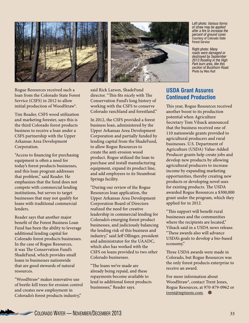
33Colorado Water — November/deCember 2013
Rogue Resources received such a loan from the Colorado State Forest Service (CSFS) in 2012 to allow initial production of WoodStraw®.
Tim Reader, CSFS wood utilization and marketing forester, says this is the third Colorado forest products business to receive a loan under a CSFS partnership with the Upper Arkansas Area Development Corporation.
“Access to financing for purchasing equipment is often a need for today’s forest products businesses, and this loan program addresses that problem,” said Reader. He emphasizes that the fund does not compete with commercial lending institutions, but serves to target businesses that may not qualify for loans with traditional commercial lenders.
Reader says that another major benefit of the Forest Business Loan Fund has been the ability to leverage additional lending capital for Colorado forest products businesses. In the case of Rogue Resources, it was The Conservation Fund’s ShadeFund, which provides small loans to businesses nationwide that are good stewards of natural resources.
“WoodStraw® makes innovative use of beetle-kill trees for erosion control and creates new employment in Colorado’s forest products industry,”
said Rick Larson, ShadeFund director. “This fits nicely with The Conservation Fund’s long history of working with the CSFS to conserve Colorado ranchland and forestland.”
In 2012, the CSFS provided a forest business loan, administered by the Upper Arkansas Area Development Corporation and partially funded by lending capital from the ShadeFund, to allow Rogue Resources to create the anti-erosion wood product. Rogue utilized the loan to purchase and install manufacturing equipment, expand its product line, and add employees to its Steamboat Springs facility.
“During our review of the Rogue Resources loan application, the Upper Arkansas Area Development Corporation Board of Directors realized the need for creative leadership in commercial lending for Colorado’s emerging forest product businesses, and judiciously balancing the lending risk of this business and industry,” said Jeff Ollinger, president and administrator for the UAADC, which also has worked with the CSFS on loans provided to two other Colorado businesses.
“The loans we’ve made are already being repaid, and these repayments become available to lend to additional forest products businesses,” Reader says.
USDA Grant Assures Continued ProductionThis year, Rogue Resources received another boost to its production potential when Agriculture Secretary Tom Vilsack announced that the business received one of 110 nationwide grants provided to agricultural producers and rural businesses. U.S. Department of Agriculture (USDA) Value-Added Producer grants help create jobs and develop new products by allowing agricultural producers to increase income by expanding marketing opportunities, thereby creating new products or developing novel uses for existing products. The USDA awarded Rogue Resources a $300,000 grant under the program, which they applied for in 2012.
“This support will benefit rural businesses and the communities where the recipients are located,” Vilsack said in a USDA news release. “These awards also will advance USDA’s goals to develop a bio-based economy.”
Three USDA awards were made in Colorado, but Rogue Resources was the only forest products enterprise to receive an award.
For more information about WoodStraw®, contact Trent Jones, Rogue Resources, at 970-879-0962 or [email protected].
Left photo: Various forms of straw may be applied after a fire to increase the percent of ground cover. Courtesy of Colorado State Forest Service
Right photo: Many roads were damaged or destroyed by September 2013 flooding in the High Park burn area, like this section of Buckhorn Road. Photo by Wes Rutt

34 the Water CeNter of Colorado State UNiverSity
Jeffrey J. SteinerDeputy Director of the Colorado Agricultural Experiment Station
Agricultural Experiment Station Colorado State University 3001 Campus Delivery Fort Collins, CO 80523-3001 Phone: (970) 491-6839 [email protected]
Facu
lty P
rofil
eJeffrey Steiner
Lindsey Middleton, Editor, Colorado Water Institute
Jeffrey Steiner came to Colorado State University (CSU) in July
2013 to serve as Deputy Director of the Colorado Agricultural Experiment Station (AES) and Associate Dean for Research in the College of Agricultural Sciences.
Steiner spent the previous 24 years working for the U.S. Department of Agriculture (USDA), where he served as a scientist, and more recently as a National Program Leader with the Agricultural Research Service (ARS) national headquarters staff in Beltsville, Maryland. He has led national research efforts in Agricultural System Competitiveness and Sustainability; Pasture, Forage, and Rangeland Systems; and Biomass Production Systems.
Steiner’s experiences in agricultural production and biomass led him to Washington,
D.C., where he served as Senior Advisor for Bioenergy in the USDA Office of the Chief Scientist. During that time he helped write the White House report for biofuels, “Growing America’s Fuel.” He also served on various public-private technical working groups including the USDA-Navy partnership to develop biofuels for the Great Green Fleet, the USDA initiative with the Commercial Airline Alternative Fuel Initiative and FAA called Farm to Fly, and the Navy-DOE-USDA Integrated Project Team for the Advanced Drop-In Biofuels Production Project to help finance the first commercial aviation biofuel production facilities in the country. After returning to ARS, he was responsible for forming the USDA Regional Biomass Research Centers.
“I’ve have had a lot of experience working in teams,” Steiner explains, noting that he has worked with representatives from universities, public agencies, and industry on a wide range of projects. “I have always tried to keep in mind finding solutions that lead to a profitable bottom line for industry, regardless of the outside pressures that farmers and ranchers have faced.”
Steiner’s experiences began on the West Coast, where he was raised on a diversified family farm. He received his bachelor’s and master’s degrees in Plant Science at California State University Fresno, and his Ph.D.
in Seed Production and Technology from Oregon State University. He began his professional career at Fresno State teaching irrigated agronomy and researching vegetable and forage seed crops. “I began my water related research in California, partnering with the USDA in crop water balance work,”
says Steiner, “specifically determining ways to optimize crop growth for seed quality and yield.” Later, after joining the USDA in Oregon, he helped determine the impacts of conservation practices for grass seed producers on water and natural resource quality in the Willamette Valley.
Since joining CSU, says Steiner, “I have been able to quickly engage a good number of talented faculty, and have found the industry partners to be very supportive.” These contacts have provided excellent opportunities for him to learn about the state, and challenges that need to be solved.
Steiner envisions Experiment Station investments will continue to help support innovative research to find ways to better manage the water we have available in the state, as well as develop technologies such as new crop varieties and livestock management practices that help stabilize production and reduce input costs—particularly as we face extreme weather conditions. He also notes the importance of research that helps to identify the best ways to manage land by users for different purposes. The interface between urban and suburban areas with agricultural and natural areas will continue to be important, particularly as the demands within the state increase as its population grows.
Steiner says that in addition to visiting research centers and meeting industry leaders around the state, he has been able to become involved with representatives from various student organizations on campus. As with research teams, he hopes to add value to faculty and students at the university by supporting research, meeting with other departments to see how the AES can serve their needs, and be a bridge to more effective partnerships among researchers on campus and with industry.

35Colorado Water — November/deCember 2013 35
David I. McLean, Ph.D., P.E.Professor and Dean College of Engineering Colorado State University Room 202, Engineering Building Fort Collins, CO 80523-1301 Phone: (970) 491-4359; Fax: (970) 491-5569 [email protected]
Faculty ProfileDavid McLean
Lindsey Middleton, Editor, Colorado Water Institute
David McLean returned this year to Colorado State University
to become the new College of Engineering Dean. He moved to Colorado from Washington, where he was a faculty member at Washington State University for 26 years, and where he also served in a number of administrative positions. “I served as an associate dean for a college [at WSU] for a time, and I enjoyed it,” says McLean. “I was positively affecting those around me.” McLean had previously spent time at CSU earning his master’s degree.
Since arriving at CSU in the summer of 2013, McLean has been undergoing a strategic planning process that will support his goals for the College. “We are going to grow research and education activities,” says McLean, also noting an effort to focus on key areas, such as the environment. One of the research projects ongoing in the college, led by Ken Carlson and others, and in cooperation with oil and gas companies, involves processing water used in fracking so that it may be reused—this would reduce the amount of potable water brought to fracking sites.
McLean also plans to encourage education and outreach programs. He notes the strong involvement and success of numerous student groups with the college, including the Society of Women Engineers, and says the college also plans to reach out to K-12 students to stimulate interest in with STEM (science, technology, engineering, and math) learning alongside CH2M HILL.
“Water has been a strength at CSU for many years,” says McLean of CSU’s water-related programs, many of which are affiliated with the College of Engineering. “It’s amazing to me the number of people I meet who are
leaders in water that have received their educations at CSU.”
He foresees a number of emerging issues relating to water becoming more important to the world, including issues arising because of a changing climate. He notes altered rainfalls and snowmelt patterns, and says that accessing water may require a change in how we store and capture water within the state. Also of importance, says McLean, are the issues of access to clean water as it relates to population growth and tradeoffs between urban use, farm use, and industry. Most of McLean’s professional experiences are in research and academia. While a master’s student here at CSU, McLean had the opportunity to teach as a substitute instructor for a several weeks, and he says this experience represented a turning point in his career plans when he was able to reach out to the students and help them learn. “It changed my plans,” he says—after his degree, McLean decided to pursue a doctorate at Cornell University with the goal of becoming a university professor.
While at Washington State University, McLean’s research and teaching focused mainly on structures. For one project, he led a team of researchers in the area of improved design of waterfront structures, such as piers. The team developed a new composite material to replace creosote-treated timbers. Creosote acts to preserve the wood, but it has also been identified as a carcinogen and damaging to the environment. The developed material was similar to composite decking material in that it combined recycled plastic and wood to protect the structure without chemicals.
In addition to this research, during McLean’s time at
WSU, he served as director of the Transportation Research Center, improving research in the areas of sustainable transportation, alternative energy sources, improved efficiency of existing transportation systems, and low-impact development. While in this role, McLean also gained experience developing partnerships with other universities and groups such as the Washington State Department of Transportation and the Federal Highway Administration.
McLean’s experience in academia, research, and industry—he worked as a research structural engineer with the National Bureau of Standards and as a construction engineer with the Louisiana Department of Transportation—will serve the CSU College of Engineering well in his leadership role as dean.

36
Water Research AwardsColorado State University
(September 16, 2013 to November 15, 2013)
Green Mountain Reservoir, Colorado. Photo by Scott Ingram
Arabi, Mazdak, Civil & Environmental Engineering, USDA-ARS-Agricultural Research Service, Delivery of the OMS-based AGES-W Resource Concerns Assessment Model for Evaluating Water/Nutrient Management and Conservation Effects, $30,000
Arabi, Mazdak, Civil & Environmental Engineering, USDA-NIFA-National Institute of Food and Agriculture, Improved Assessment of Nitrogen and Phosphorus Fate and Transport for Irrigated Agricultural Watersheds in Semi-Arid Regions, $488,500
Bagley, Calvin F, CEMML, DOD-ARMY-Corps of Engineers, Wetland and Waterbody Mapping and Assessment Study for DTA, $434,000
Caldwell, Elizabeth D, CEMML, DOD-ARMY-Corps of Engineers, Stormwater Inventory and Condition Assessment, $428,286
Carlson, Kenneth H, Civil & Environmental Engineering – 1372, State of Colorado Regional Real-time Monitoring of Oil and Gas Operations, $230,000
Chavez, Jose L, Civil & Environmental Engineering, USDA-US Department of Agriculture, Estimating Evapotranspiration and Plant Water Stress with Remote Sensing, $5,000
Chavez, Jose L, Civil & Environmental Engineering, Colorado Water Conservation Board, Implementation of Deficit Irrigation Regimes: Demonstration and Outreach, $124,734
Clements, William H, Fish, Wildlife & Conservation Biology, DOI-USGS-Geological Survey, Use of Stream Microcosm Experiments to Evaluate Effects of Elevated Major Ions on Aquatic Ecosystem, $100,082
Clements, William H, Fish, Wildlife & Conservation Biology, Colorado Division of Parks and Wildlife, Benthic Macroinvertebrate Sampling on the Gunnison River, CO, $8,999
De Long, Susan K, Civil & Environmental Engineering, Environmental Research & Education Found, Advancing Multi-stage Anaerobic Digestion Technologies through Improved Hydrolysis Processes, $118,272
Fontane, Darrell G, Civil & Environmental Engineering, Water Resources University (Vietnam), Capacity Building of Vietnam Water Resources University, $118,619
Grunau, Lee, Colorado Natural Heritage Program, Middle Rio Grande Conservancy District, Middle Rio Grande Conservation Action Plan, $20,000
Haley, Scott D, Soil & Crop Sciences, Colorado Wheat Administrative Committee Wheat Breeding - Drought and High Temperature Stress Tolerance Research, $93,500
Loftis, Jim C, Civil & Environmental Engineering, DOI-NPS-National Park Service, Legacy Water Quality Data Reclamation, Digitization, and Archiving, $97,880
McKay, John K, Bioagricultural Sciences & Pest Mgt, University of Maryland, TRMS:Cell-Type Specific Networks:Systems Analysis and Natural Variation in Brassica Guard Cell Response to Drought, $219,377
Myrick, Christopher A, Fish, Wildlife & Conservation Biology, DOI-USFWS-Fish & Wildlife Service, Improving Rockramp Fishway Designs for Small-Bodied Plains Fishes, $166,460
Niemann, Jeffrey D, Civil + Environmental Engineering, USDA-ARS-Agricultural Research Service, Hydrology Tool, $78,500
Ramirez, Jorge A, Civil & Environmental Engineering, NSF - National Science Foundation, WATER-IGERT: Integrated Water Atmosphere and Ecosystem Education and Research, $599,944
Ramirez, Jorge A, Civil & Environmental Engineering, USDA-USFS-Forest Research, Application of the Variable Infiltration Capacity Model to Estimate Water Yield and Access Vulnerability of Water, $33,000
Sanders, Thomas G, Civil & Environmental Engineering, DOI-NPS-National Park Service, Integration of NPS/USGS Water Resources Science Applicable to Management of Protected Areas, $83,512
Suter, Jordan, Agricultural + Resource Economics, NSF - National Science Foundation, Collaborative Research: An Experimental Economics Investigation of Groundwater Resource Dynamics, $58,233
Thornton, Christopher I, Civil & Environmental Engineering, Various “For Profit” Sponsors, Full Scale Product Evaluation During Wave Overtopping, $39,870
Waskom, Reagan M, Colorado Water Institute, Colorado Dept Public Health & Environ, NPS Outreach Coordinator, $132,762
Waskom, Reagan M, Colorado Water Institute, USDA-NIFA-National Institute of Food and Agriculture, Moving Forward on Agricultural Water Conservation in the Colorado River Basin, $649,000

37
2/26– 2014 AirWaterGas Sustainability Research5/22 Network Annual Meeting; Boulder, CO
Beginning on February 26th, on Tuesday nights through May, a speaker with substantial expertise on natural gas development will provide a measured, honest exploration of this controversial topic. centerwest.org/events/airwatergas
30-2 American Water Works Association 2014 Sustainable Water Management Conference; Denver, COPresenting solutions for balancing the benefits of conservation with the costs, managing infrastructure, developing robust supply models and watershed management plans, water reuse, resource management, green infrastructure, and more.www.awwa.org/conferences-education/conferences/sustainable-water-management.aspx
31-2 2014 Federal Water Issues Conference; Washington, D.C.National Water Resources Association presents Federal Water Issueswww.nwra.org/events/2014/3/federal-water-issues-conference-2/
1-4 40th Annual Center for Great Plains Studies Symposium “Drought in the Life, Cultures and Landscapes of the Great Plains”www.unl.edu/plains
March
April
29-31 Colorado Water Congress 2014 Annual Convention; Denver, COThe Colorado Water Congress is the premier water industry event in the state, attracting 500+ attendees that convene for networking and collaboration on the important water issues of the day. www.cowatercongress.org/
30 CSU Water Tables 2014; Denver, CODavid Schorr from Tel Aviv University’s Buchmann Faculty of Law will discuss water issues in relation to his book, The Colorado Doctrine: Water Rights, Corporations, and Distributive Justice on the American Frontier.lib.colostate.edu/archives/water/water-tables/2014/
8 Poudre River Forum; Loveland, COMaking the Poudre River the world’s best example of a healthy, working river.www.cwi.colostate.edu/thepoudrerunsthroughit/
10-12 NIWR Annual Meeting; Washington, D.C“Celebrating 50 Years of the Water Resources Research Act and NIWR Partnerships.”https://wrrc.arizona.edu/niwr
18-19 2014 Tamarisk Coalition Research and Management Conference; Grand Junction, COLand and resource managers, private land owners, researchers, students, and others will convene in a collaborative venue to learn about and discuss the latest trends in riparian restoration and ecology.www.tamariskcoalition.org/programs/conferences/2014
JanuaryCalendar
February

The Water Center of Colorado State University 1033 Campus Delivery Fort Collins, Colorado 80523-1033
NONPROFITORGANIZATION
U.S. POSTAGEPAID
Fort Collins, Colorado 80523Permit Number 19
Visit Our WebsitesColorado Water Institute: www.cwi.colostate.edu
CSU Water Center: www.watercenter.colostate.edu
AttentiOn subscribersPlease help us keep our distribution list up to date. If you prefer to receive the newsletter electronically or have a
name/address change, please visit our website and click on Subscriptions.
Colorado Water OnlineVisit the CWI web site to access a PDF version of our current newsletter. To
download past issues of our newsletter, click on Newsletter Archives.
Dam at Chapman Reservoir. Photo by John Van Benthuysen