Embed Size (px)
Citation preview

NG9-1-1 / LAND MOBILE RADIO & LTE / EMERGENCY NOTIFICATION
Copyright © 2014 Airbus DS Communications, Inc. All rights reserved.
Lights, Camera, NG9-1-1!
Diana Gijselaers [email protected] August 26, 2015
2

Copyright © 2014 Airbus DS Communications, Inc. All rights reserved.
TODAY
•GIS •NG9-1-1 Basics •How GIS is used in NG9-1-1 •NG9-1-1 Call Flow Skit
3

Copyright © 2014 Airbus DS Communications, Inc. All rights reserved. Page 4
WHAT IS GIS?
Geographic Information Systems According to Esri: ‘A geographic information system
(GIS) integrates hardware, software, and data for capturing, managing, analyzing, and displaying all forms of geographically referenced information.’

Copyright © 2014 Airbus DS Communications, Inc. All rights reserved. Page 5
WHAT DOES GIS DO?
Store, reference, combine, and analyze multiple layers – NG9-1-1Database Allows you to query based on geographic location –
NG9-1-1Database Allows you to Visualize data - E9-1-1 & NG9-1-1Map

Copyright © 2014 Airbus DS Communications, Inc. All rights reserved. Page 6
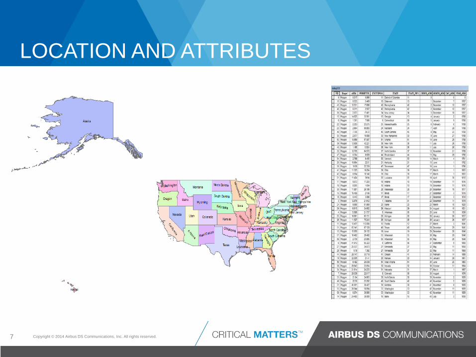
WHAT DOES GIS DO?
GIS works with geographic features and their corresponding attribute information. • Vector - Point, line, polygon representations of real
world features with associated attributes
Copyright © 2014 Airbus DS Communications, Inc. All rights reserved.
LOCATION AND ATTRIBUTES
7

Copyright © 2014 Airbus DS Communications, Inc. All rights reserved.
MAPS TELL A STORY
8

Copyright © 2014 Airbus DS Communications, Inc. All rights reserved.
HOW IS GIS USED IN E9-1-1?
Confirming/validating emergency caller’s location Display emergency caller’s location on a map in order to determine location Provide vehicular routing
Map Display

Copyright © 2014 Airbus DS Communications, Inc. All rights reserved.
Maps can reveal data and help reach conclusions
MAPS CAN TELL A STORY IN A LANGUAGE EVERYONE CAN UNDERSTAND
10
Copyright © 2014 Airbus DS Communications, Inc. All rights reserved.
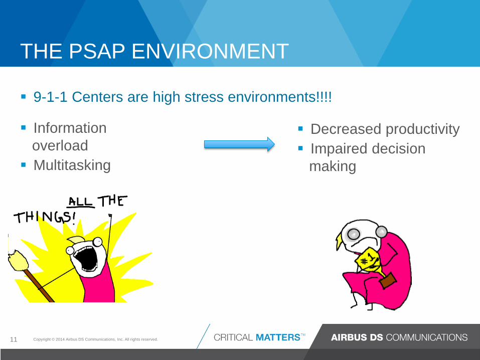
THE PSAP ENVIRONMENT
11
Information overload Multitasking
9-1-1 Centers are high stress environments!!!!
Decreased productivity Impaired decision
making
Copyright © 2014 Airbus DS Communications, Inc. All rights reserved.
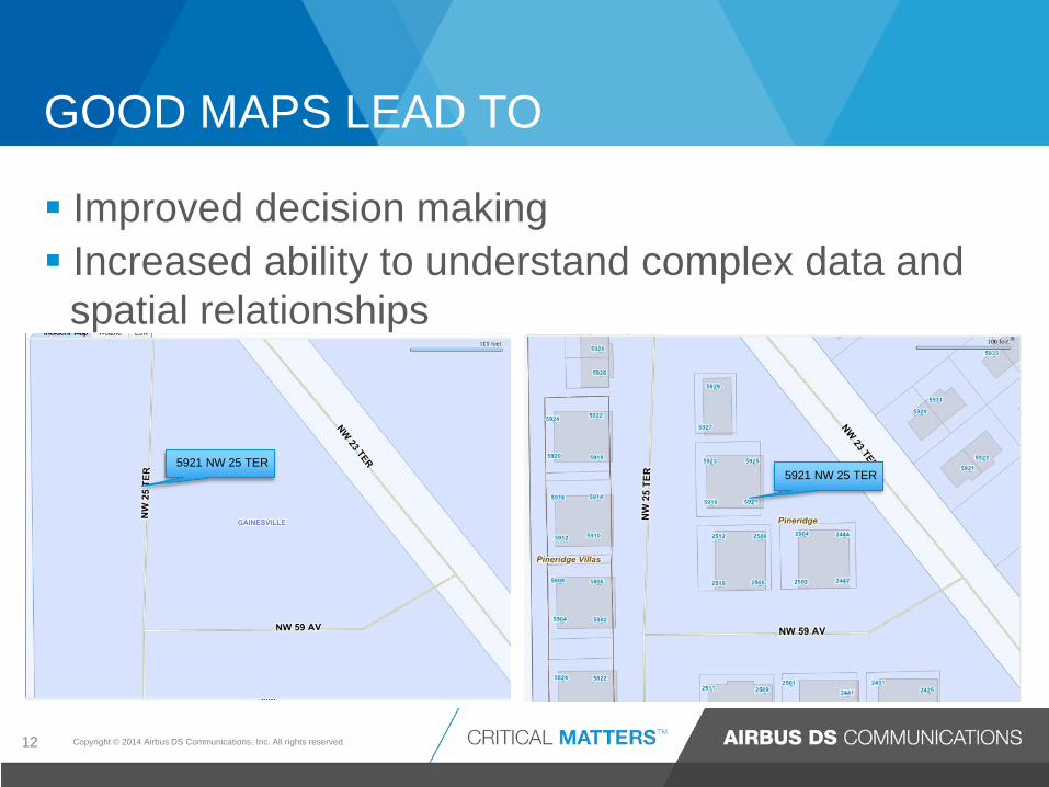
GOOD MAPS LEAD TO
12
Improved decision making Increased ability to understand complex data and
spatial relationships
5921 NW 25 TER 5921 NW 25 TER

Copyright © 2014 Airbus DS Communications, Inc. All rights reserved.
E9-1-1 LOCATION VALIDATION & CALL ROUTING
Master Street Address Guide (MSAG) – A data base of street names and house number ranges within their associated defining Emergency Services Zones (ESZs) and their associated Emergency Service Numbers (ESNs) to enable proper routing of 9-1-1 calls. Primary functions: validate address and assign ESN. Selective Router (SR) – The routing of a 9-1-1 call to the proper PSAP based upon the location of the caller. Selective routing is controlled by the ESN which is derived from the customer location. Selective Routing Data Base (SRDB) – The routing table that contains telephone number to ESN relationships which determine the routing of 9-1-1 calls.
13

Copyright © 2014 Airbus DS Communications, Inc. All rights reserved.
E9-1-1 TO NG9-1-1
14
MSAG GIS/LVF
Selective Router ESRP
SRDB GIS/ECRF
E9-1-1 NG9-1-1

Copyright © 2014 Airbus DS Communications, Inc. All rights reserved.
HOW IS GIS USED IN NG9-1-1?
Location Validation Geospatial Call Routing
Confirming/validating emergency caller’s
location Display emergency caller’s location on a map Provide vehicular routing
Map Display
Database

Copyright © 2014 Airbus DS Communications, Inc. All rights reserved.
NENA NG9-1-1 – I3 ELEMENTS SIMPLIFIED DIAGRAM (WITH ENGLISH SUBTITLES!)
Location Info
9-1-1 Call Routing Control
Gateway
Gateway
Pictures, Video, Graphics
Border Control
Subscriber Info
Inputs Outputs
PRF Policy Routing Function

Copyright © 2014 Airbus DS Communications, Inc. All rights reserved.
ACRONYMS!
17

Service Uniform Resource Name
nena:service:sos

Location-to-Service Translation
<?xml version="1.0" encoding="UTF-8"?> <findService xmlns="urn:ietf:params:xml:ns:lost1" recursive="true" serviceBoundary="value"> <location id="627b8bf819d0bcd4d" profile="civic"> <civicAddress xmlns="urn:ietf:params:xml:ns:pidf:geopriv10:civicAddr"> <country>US</country> <A1>OR</A1> <A3>Brooks</A3> <RD>APCO</RD> <STS>ST</STS> <HNO>911</HNO> </civicAddress> </location> <service>urn:service:sos</service> </findService>
Copyright © 2014 Airbus DS Communications, Inc. All rights reserved.
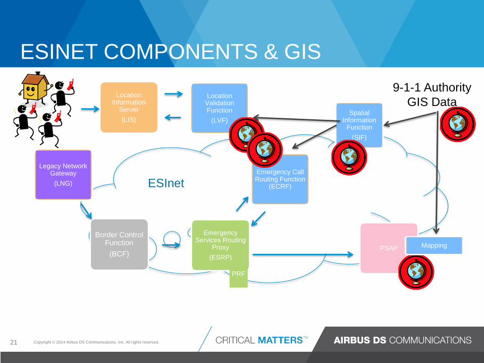
ESINET COMPONENTS & GIS
21
Border Control Function
(BCF)
Location Information
Server (LIS)
Emergency Services Routing
Proxy (ESRP)
Location Validation Function
(LVF)
PSAP
Emergency Call Routing Function
(ECRF)
Spatial Information
Function (SIF)
Mapping
Legacy Network Gateway
(LNG)
9-1-1 Authority GIS Data
PRF
ESInet

Copyright © 2014 Airbus DS Communications, Inc. All rights reserved.
ACT I: GIS DATA PROVISIONING GIS Data is created and maintained at the local level
22
BCF ESRP
LVF
PSAP
ECRF
Map
Spatial Interface
(SI)
Local Government/ 9-1-1 Authority GIS
Data
SI – Spatial Information Function • Base database for NG9-1-1 – maintains copies of required GIS layers •Nearly all location related data is derived from the SI. SI supplies data for the ECRF/LVF and map views for alternate PSAPs •Provisioned by the 9-1-1 Authority, or other government agencies •Provides an interface between an authoritative copy of GIS data and Functional Elements within the ESInet
Here’s your GIS
Data
Three things done by the SI: •Projection – WGS 84 •Layer replication – WFS + ATOM GeoRSS feed •Transform data to CLDXF

Copyright © 2014 Airbus DS Communications, Inc. All rights reserved.
PURPOSES OF CLDXF
• Map a profile between IETF PIDF-LO and NENA
PIDF - Presence Information Data Format “hello, it’s me and I’m waiting for an answer”
LO - Location Object “this is exactly where I am” coordinate location or civic address
• Support the exchange of address data by providing “definitive set of core civic location data elements”
o Ensure portability of address data
o Permit efficient design of software systems
o Meet functional needs of call-routing and dispatch
Civic Location Data Exchange Format – NENA-STA-004

Location-to-Service Translation
<?xml version="1.0" encoding="UTF-8"?> <findService xmlns="urn:ietf:params:xml:ns:lost1" recursive="true" serviceBoundary="value"> <location id="627b8bf819d0bcd4d" profile="civic"> <civicAddress xmlns="urn:ietf:params:xml:ns:pidf:geopriv10:civicAddr"> <country>US</country> <A1>OR</A1> <A3>Brooks</A3> <RD>APCO</RD> <STS>ST</STS> <HNO>911</HNO> </civicAddress> </location> <service>urn:service:sos</service> </findService>

Copyright © 2014 Airbus DS Communications, Inc. All rights reserved.
• Road Centerline - Required • Emergency Services Boundary - Required •Authoritative Boundary- Required
•Address Points – Strongly Recommended
Optional GIS Dataset for ECRF/LVF – can be useful to particular ECRF/LVF implementations to facilitate the URI mapping of invalid or incomplete civic location •States or Equivalents – Strongly Recommended •Counties or Equivalents – Strongly Recommended •Municipal Boundary – Strongly Recommended
GIS DATA PROVISIONED BY THE SI
25
Copyright © 2014 Airbus DS Communications, Inc. All rights reserved.
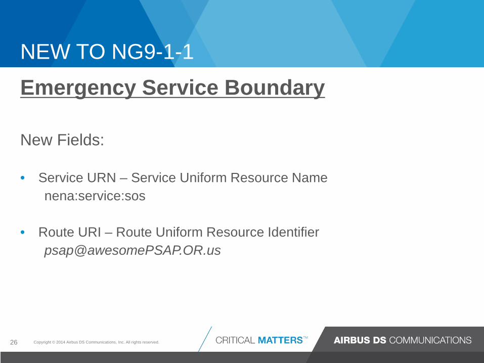
Emergency Service Boundary New Fields: • Service URN – Service Uniform Resource Name nena:service:sos
• Route URI – Route Uniform Resource Identifier [email protected]
NEW TO NG9-1-1
26

Copyright © 2014 Airbus DS Communications, Inc. All rights reserved.
LOCATION VALIDATION
27
E9-1-1 MSAG
Tabular database
NG9-1-1 LVF
GIS database

Copyright © 2014 Airbus DS Communications, Inc. All rights reserved.
ACT II: NG9-1-1 LOCATION VALIDATION
28
Location Information
Server (LIS)
Location Validation Function
(LVF)
Emergency Call Routing Function
(ECRF)
Spatial Information Function
(SIF)
9-1-1 Authority GIS Data
Is this a valid location in GIS?
YES or NO
LIS – Location Information Server •Calling devices query the LIS •Civic addresses are validated prior to being stored in the LIS by the LVF – validated against the GIS •Returns a PIDF-LO (Presence Information Data Format – Location Object) – can be a civic address or a geo-coordinate
LVF – Location Validation Function • Pre-validation, validates before loading to the LIS database •Similar to MSAG, verifies that the civic location matches a known address in the 9-1-1 Authorities service area •Able to validate an address, not just address range •Receives as input: PIDF-LO and service URN – returns – location validation •Queried by LOST protocol
PIDF-LO + service URN
‘yes’ or ‘no’

Copyright © 2014 Airbus DS Communications, Inc. All rights reserved.
HOW IS GIS USED IN NG9-1-1?
920 NE 5TH PL, Gainesville, FL 1020 NE 5TH PL, Gainesville, FL 1107 NE 5TH PL, Gainesville, FL
Location Validation – greater accuracy with address points
preDir Street Low High Comm State O/E ESN
NE 5TH PL 920 929 Gainesville FL B 1
NE 5TH PL 1004 1035 Gainesville FL B 1
NE 5TH PL 1102 1115 Gainesville FL B 1

Copyright © 2014 Airbus DS Communications, Inc. All rights reserved.
CALL ROUTING
30
E9-1-1 Selective Router
Tabular query
NG 9-1-1 ESRP/ECRF
GIS query
Copyright © 2014 Airbus DS Communications, Inc. All rights reserved.
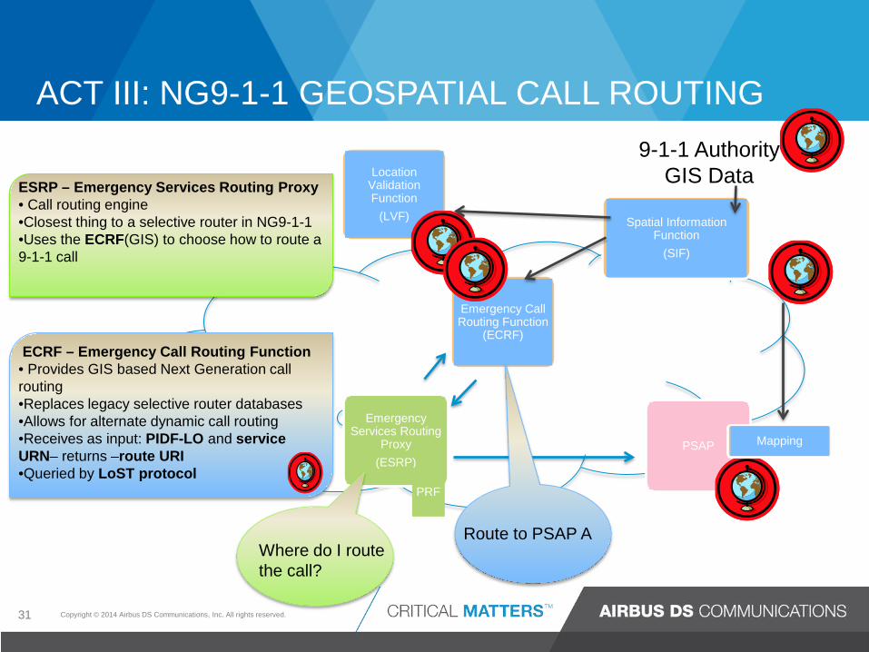
ACT III: NG9-1-1 GEOSPATIAL CALL ROUTING
31
Emergency Services Routing
Proxy (ESRP)
Location Validation Function
(LVF)
PSAP
Emergency Call Routing Function
(ECRF)
Spatial Information Function
(SIF)
Mapping
9-1-1 Authority GIS Data
Where do I route the call?
Route to PSAP A
ESRP – Emergency Services Routing Proxy • Call routing engine •Closest thing to a selective router in NG9-1-1 •Uses the ECRF(GIS) to choose how to route a 9-1-1 call
ECRF – Emergency Call Routing Function • Provides GIS based Next Generation call routing •Replaces legacy selective router databases •Allows for alternate dynamic call routing •Receives as input: PIDF-LO and service URN– returns –route URI •Queried by LoST protocol
PRF

Copyright © 2014 Airbus DS Communications, Inc. All rights reserved.
HOW GIS IS USED IN NG9-1-1 Geospatial call routing – ECRF GIS Query
32
Location coordinate of emergency call
PSAP Boundary with Service URN
Route URI from PSAP boundary
nena:service:sos [email protected]
x,y
[email protected] [email protected] [email protected] [email protected]

Copyright © 2014 Airbus DS Communications, Inc. All rights reserved.
HOW GIS IS USED IN NG9-1-1
Route to a PSAP
Route to Mobile Command Center
Route to a Queue
Geospatial call routing
33
Copyright © 2014 Airbus DS Communications, Inc. All rights reserved.
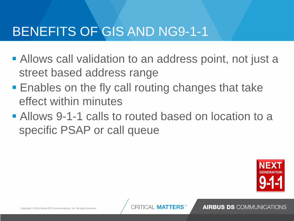
BENEFITS OF GIS AND NG9-1-1
Allows call validation to an address point, not just a street based address range Enables on the fly call routing changes that take
effect within minutes Allows 9-1-1 calls to routed based on location to a
specific PSAP or call queue

Copyright © 2014 Airbus DS Communications, Inc. All rights reserved.
ACT I: GIS DATA PROVISIONING GIS Data is created and maintained at the local level
35
BCF ESRP
LVF
PSAP
ECRF
Map
Spatial Interface (SI)
Local Government/ 9-1-1 Authority GIS
Data
SI – Spatial Interface • Base database for NG9-1-1 – maintains copies of required GIS layers •Nearly all location related data is derived from the SI. SI supplies data for the ECRF/LVF and map views for alternate PSAPs •Provisioned by the 9-1-1 Authority, or other government agencies •Provides an interface between an authoritative copy of GIS data and Functional Elements within the ESInet
Here’s your GIS
Data
Three things done by the SIF: •Projection – WGS 84 •Layer replication – WFS + ATOM GeoRSS feed •Transform data to CLDXF

Copyright © 2014 Airbus DS Communications, Inc. All rights reserved.
ACT II: NG9-1-1 LOCATION VALIDATION
36
Location Information
Server (LIS)
Location Validation Function
(LVF)
Emergency Call Routing Function
(ECRF)
Spatial Information Function
(SIF)
9-1-1 Authority GIS Data
Is this a valid location in GIS? YES or NO
LIS – Location Information Server •Calling devices query the LIS •Civic addresses are validated prior to being stored in the LIS by the LVF – validated against the GIS •Returns a PIDF-LO (Presence Information Data Format – Location Object) – can be a civic address or a geo-coordinate
LVF – Location Validation Function • Pre-validation, validates before loading to the LIS database •Similar to MSAG, verifies that the civic location matches a known address in the 9-1-1 Authorities service area •Able to validate an address, not just address range •Receives as input: PIDF-LO and service URN – returns – location validation •Queried by LOST protocol

Copyright © 2014 Airbus DS Communications, Inc. All rights reserved.
ACT III: NG9-1-1 GEOSPATIAL CALL ROUTING
37
Emergency Services Routing
Proxy (ESRP)
Location Validation Function
(LVF)
PSAP
Emergency Call Routing Function
(ECRF)
Spatial Information Function
(SIF)
Mapping
9-1-1 Authority GIS Data
Where do I route the call?
Route to PSAP A
ESRP – Emergency Services Routing Proxy • Call routing engine •Closest thing to a selective router in NG9-1-1 •Uses the ECRF(GIS) to choose how to route a 9-1-1 call
ECRF – Emergency Call Routing Function • Provides GIS based Next Generation call routing •Replaces legacy selective router databases •Allows for alternate dynamic call routing •Receives as input: PIDF-LO and service URN– returns –route URI •Queried by LoST protocol
PRF

Copyright © 2014 Airbus DS Communications, Inc. All rights reserved.
WHAT TO TAKE AWAY
‘Check’ Your NG9-1-1 GIS Checklist: Do you know the Importance of GIS in NG 9-1-1
environment? Do you understand NG9-1-1 Call Flow and which components
rely on GIS? Is your current GIS data ready for NG9-1-1? Is your GIS data in sync and consistent with the MSAG and
ALI?
38
![NG9-1-1 Service: Media Communication Line Services (MCLS) · Video Relay Service NG9-1-1: A person calls 9-1-1 using multimedia [caller profile] When a person calls NG9-1-1, the signaling](https://img.pdfslide.net/doc/110x75/5f16600c0799f85d7e1e9706/ng9-1-1-service-media-communication-line-services-mcls-video-relay-service-ng9-1-1.jpg)