Embed Size (px)
Citation preview
The overall classification of this presentation is:
Robert Wong, Senior Analyst – NGA GNSS Division
NGA Support to Civilian Positioning, Navigation, and Timing (PNT)
UNCLASSIFIED
Presentation to Civil GPS Service Interface Committee at ION GNSS+ 2016
Adapted from NGA Briefing provided to U.S. Coast Guard HQ
2
Outline
• NGA Agency Mission
• NGA’s Role in Civil GPS • Support to OCS/2SOPS
• Global reference Frame, Geophysical models
• Precise Orbit Determination
• Web Based PPP and Geoid Heights
• Global Monitoring of Civil Signals (NAV/CNAV)
• Laser Reflectors on GPS III
• Contribution to ITRF
Approved for Public Release, 16-603
3
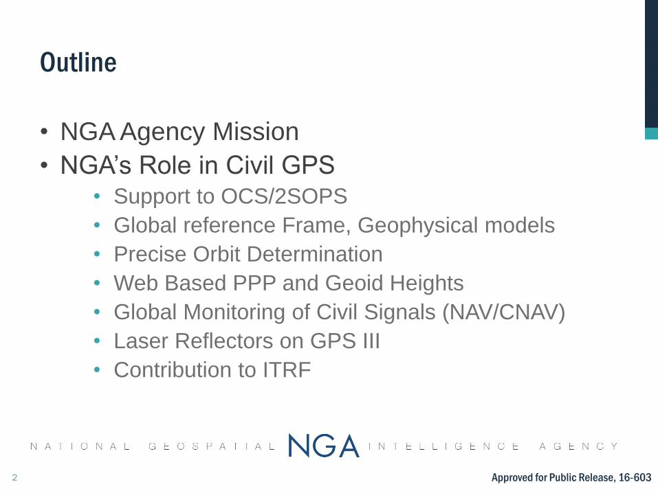
The NGA Mission The National Geospatial-Intelligence Agency (NGA) provides
timely, relevant, and accurate geospatial intelligence – or GEOINT
– in support of national security objectives.
“NGA has grown into a critical link in America’s intelligence apparatus and made a decisive difference to our national security and recent war effort.”
– Robert M. Gates, Former Secretary of Defense
NGA’s Mission Set
•Strategic Intelligence
•Warfighter Support
•Counterterrorism
•Counterproliferation
•Cyber Warfare
•Homeland Security
•Safety of Navigation
•Humanitarian Relief •Foundation Data
Warfighter Support
Safety of Navigation Foundation Data
Do
D p
ho
to
Do
D p
ho
to
Approved for Public Release, 16-603
4
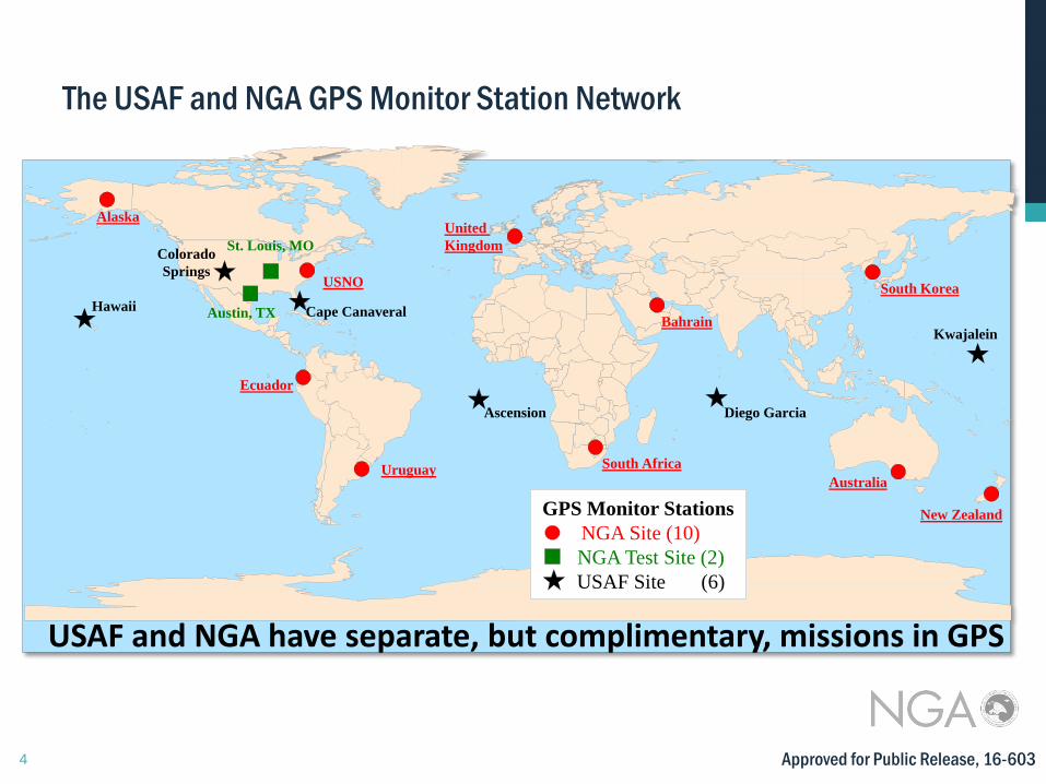
The USAF and NGA GPS Monitor Station Network
Alaska
Austin, TX
St. Louis, MO
USNO
South Africa
Bahrain
United
Kingdom
Australia
New Zealand
South Korea
Ecuador
Uruguay
GPS Monitor Stations
NGA Site (10)
NGA Test Site (2)
USAF Site (6)
Hawaii
Colorado
Springs
Ascension Diego Garcia
Kwajalein
Cape Canaveral
USAF and NGA have separate, but complimentary, missions in GPS
Approved for Public Release, 16-603
5
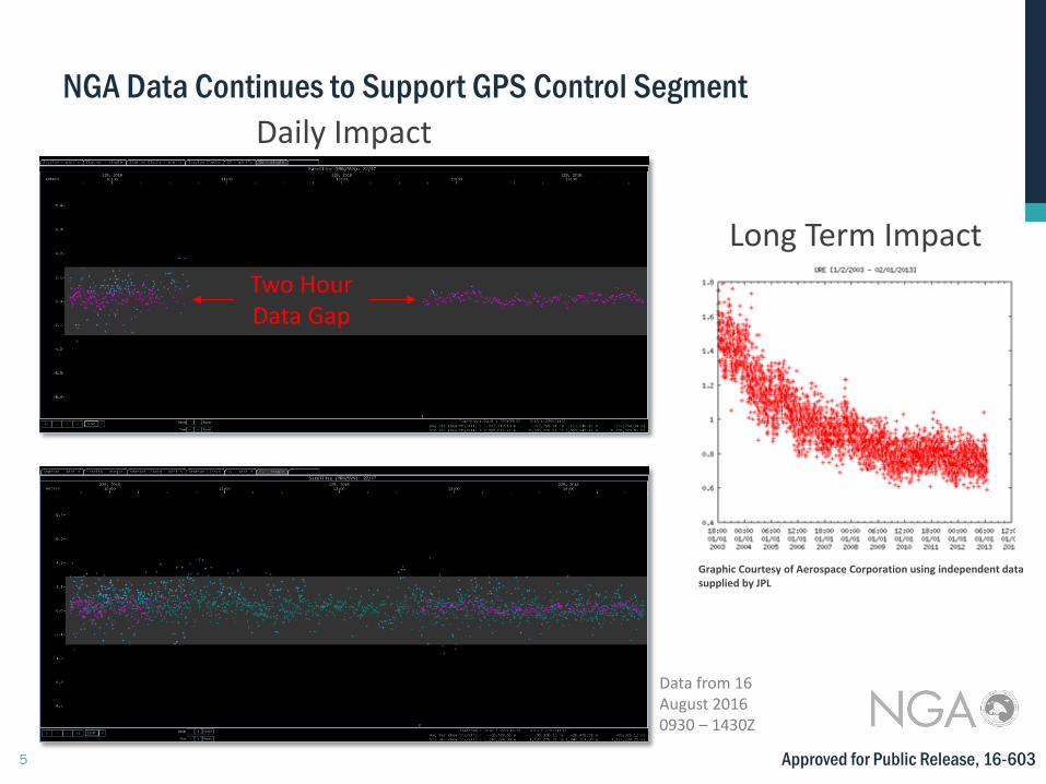
NGA Data Continues to Support GPS Control Segment
Graphic Courtesy of Aerospace Corporation using independent data supplied by JPL
Daily Impact
Long Term Impact
Two Hour Data Gap
Data from 16 August 2016 0930 – 1430Z
Approved for Public Release, 16-603
6
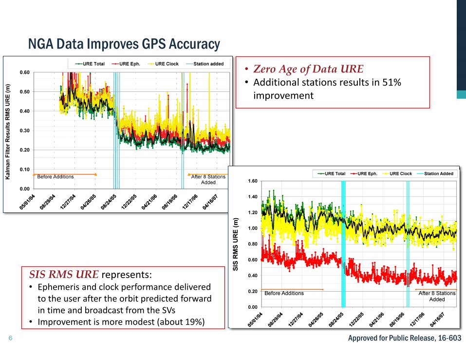
NGA Data Improves GPS Accuracy
SIS RMS URE represents: • Ephemeris and clock performance delivered
to the user after the orbit predicted forward in time and broadcast from the SVs
• Improvement is more modest (about 19%)
• Zero Age of Data URE • Additional stations results in 51%
improvement
Approved for Public Release, 16-603
7
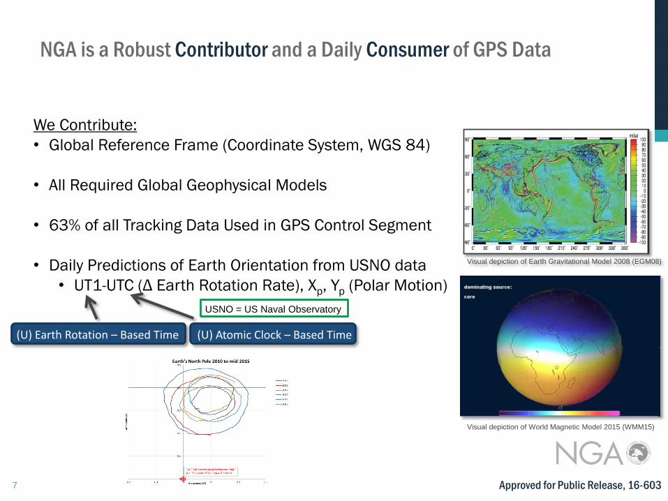
We Contribute:
• Global Reference Frame (Coordinate System, WGS 84)
• All Required Global Geophysical Models
• 63% of all Tracking Data Used in GPS Control Segment
• Daily Predictions of Earth Orientation from USNO data
• UT1-UTC (Δ Earth Rotation Rate), Xp, Yp (Polar Motion)
(U) Earth Rotation – Based Time (U) Atomic Clock – Based Time
USNO = US Naval Observatory
NGA is a Robust Contributor and a Daily Consumer of GPS Data
Visual depiction of Earth Gravitational Model 2008 (EGM08)
Visual depiction of World Magnetic Model 2015 (WMM15)
Approved for Public Release, 16-603
8
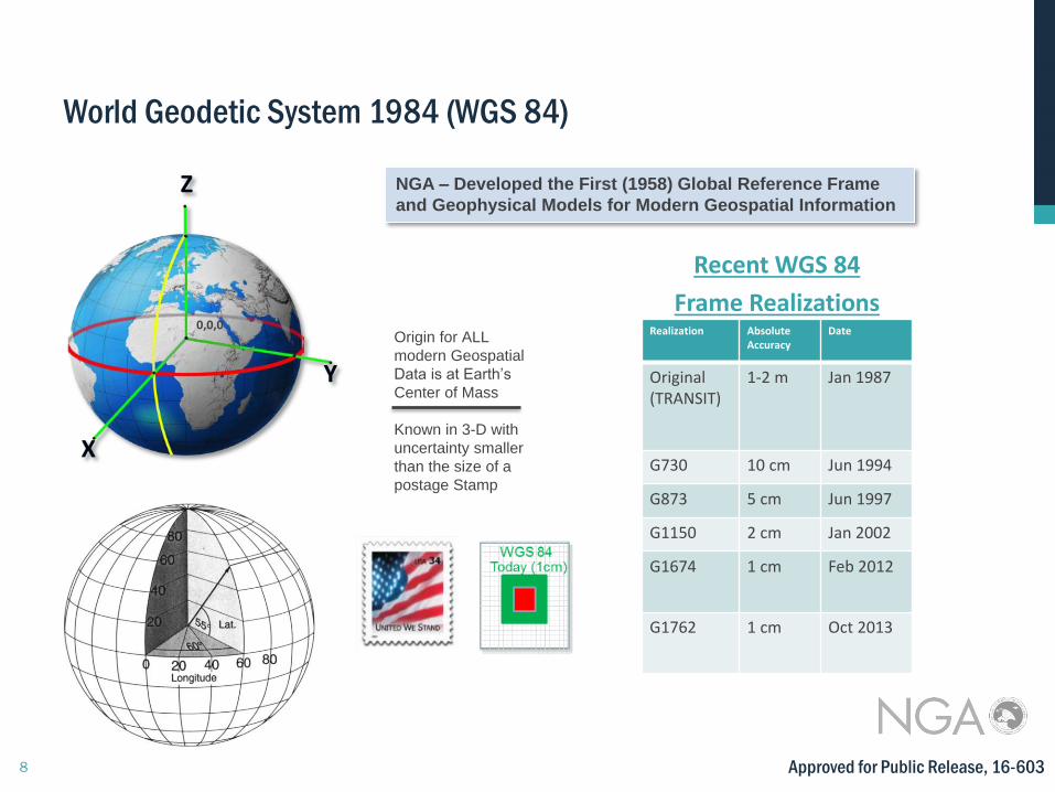
World Geodetic System 1984 (WGS 84)
Approved for Public Release, 16-603
NGA – Developed the First (1958) Global Reference Frame
and Geophysical Models for Modern Geospatial Information
Recent WGS 84
Frame Realizations
Z
Y
X
0,0,0 Realization Absolute Accuracy
Date
Original (TRANSIT)
1-2 m Jan 1987
G730 10 cm Jun 1994
G873 5 cm Jun 1997
G1150 2 cm Jan 2002
G1674 1 cm Feb 2012
G1762 1 cm Oct 2013
Origin for ALL
modern Geospatial
Data is at Earth’s
Center of Mass Known in 3-D with
uncertainty smaller
than the size of a
postage Stamp
9
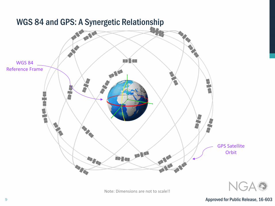
Note: Dimensions are not to scale!!
WGS 84 Reference Frame
GPS Satellite Orbit
WGS 84 and GPS: A Synergetic Relationship
Approved for Public Release, 16-603
10 Approved for Public Release, 16-603
11
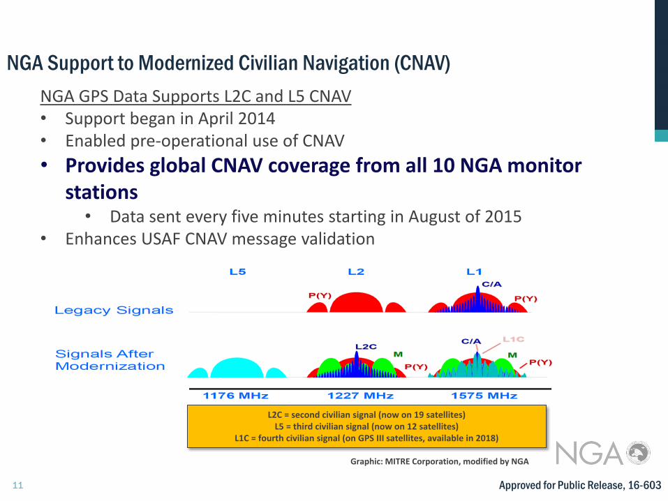
NGA Support to Modernized Civilian Navigation (CNAV)
Graphic: MITRE Corporation, modified by NGA
L2C = second civilian signal (now on 19 satellites) L5 = third civilian signal (now on 12 satellites)
L1C = fourth civilian signal (on GPS III satellites, available in 2018)
NGA GPS Data Supports L2C and L5 CNAV • Support began in April 2014 • Enabled pre-operational use of CNAV
• Provides global CNAV coverage from all 10 NGA monitor stations
• Data sent every five minutes starting in August of 2015 • Enhances USAF CNAV message validation
Approved for Public Release, 16-603
12
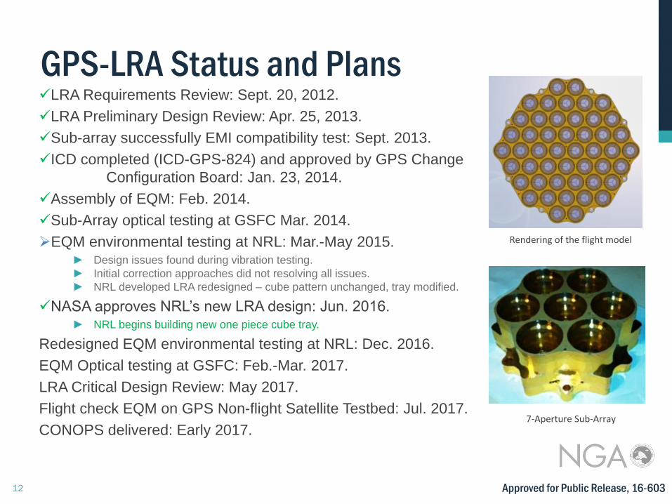
GPS-LRA Status and Plans LRA Requirements Review: Sept. 20, 2012.
LRA Preliminary Design Review: Apr. 25, 2013.
Sub-array successfully EMI compatibility test: Sept. 2013.
ICD completed (ICD-GPS-824) and approved by GPS Change
Configuration Board: Jan. 23, 2014.
Assembly of EQM: Feb. 2014.
Sub-Array optical testing at GSFC Mar. 2014.
EQM environmental testing at NRL: Mar.-May 2015. ► Design issues found during vibration testing.
► Initial correction approaches did not resolving all issues.
► NRL developed LRA redesigned – cube pattern unchanged, tray modified.
NASA approves NRL’s new LRA design: Jun. 2016. ► NRL begins building new one piece cube tray.
Redesigned EQM environmental testing at NRL: Dec. 2016.
EQM Optical testing at GSFC: Feb.-Mar. 2017.
LRA Critical Design Review: May 2017.
Flight check EQM on GPS Non-flight Satellite Testbed: Jul. 2017.
CONOPS delivered: Early 2017.
Rendering of the flight model
7-Aperture Sub-Array
Approved for Public Release, 16-603
13
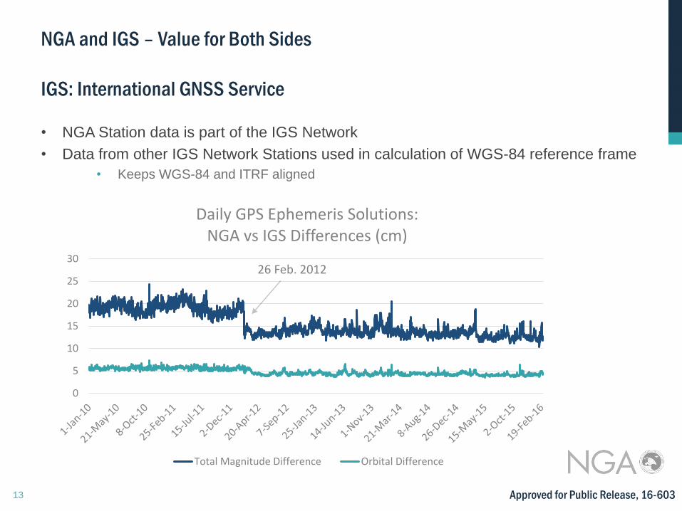
0
5
10
15
20
25
30
Daily GPS Ephemeris Solutions: NGA vs IGS Differences (cm)
Total Magnitude Difference Orbital Difference
NGA and IGS – Value for Both Sides
IGS: International GNSS Service
• NGA Station data is part of the IGS Network
• Data from other IGS Network Stations used in calculation of WGS-84 reference frame
• Keeps WGS-84 and ITRF aligned
26 Feb. 2012
Approved for Public Release, 16-603
Approved for Public Release, 16-603
http://earth-info.nga.mil/GandG/sathtml/