Embed Size (px)
Citation preview

Background Report
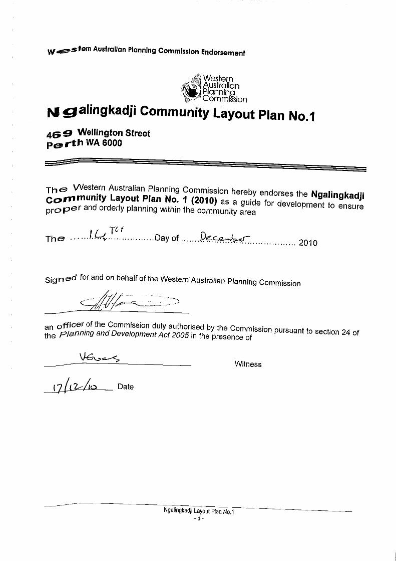
December 2010Date endorsed by WAPC
NgalingkadjiLayout Plan 1
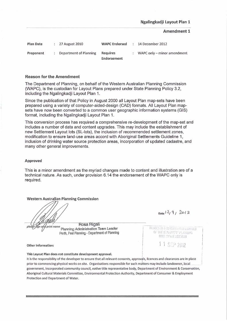
Amendments Amendment 1 - September 2012Amendment 2 - January 2018

_________________________________________________________________________________________________________ Ngalingkadji Layout Plan No.1
- A -
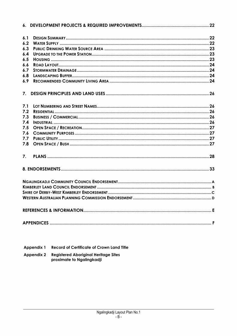
CONTENTS
CONTACTS ...................................................................................................................................... I
LIST OF ACRONYMS USED IN THIS REPORT .................................................................................... II
EXECUTIVE SUMMARY .................................................................................................................. III
PREAMBLE ......................................................................................................................................... III DEVELOPMENT AT NGALINGKADJI ....................................................................................................... IV
1 BACKGROUND ....................................................................................................................... 1
1.1 LOCATION & PHYSICAL GEOGRAPHY ........................................................................................... 1 1.2 NGALINGKADJI CLIMATE ............................................................................................................ 2 1.3 HISTORY ................................................................................................................................... 2 1.4 CLP STATUS .............................................................................................................................. 3
2. EXISTING SITUATION ................................................................................................................ 4
2.1 GOVERNANCE .......................................................................................................................... 4 2.2 LAND TENURE ............................................................................................................................ 4 2.3 NATIVE TITLE .............................................................................................................................. 6 2.4 CULTURE ................................................................................................................................... 6 2.5 ABORIGINAL HERITAGE .............................................................................................................. 7 2.6 POPULATION ............................................................................................................................. 8 2.7 HOUSING ............................................................................................................................... 10 2.8 FLOODING & DRAINAGE .......................................................................................................... 11 2.9 WATER SUPPLY ........................................................................................................................ 11 2.10 ACCESS & DEDICATED ROADS ................................................................................................ 12 2.11 INTERNAL ROAD LAYOUT ......................................................................................................... 13 2.12 COMMUNITY AND SOCIAL SERVICES ........................................................................................ 14 2.13 ELECTRICITY SUPPLY ................................................................................................................ 16 2.14 WASTEWATER ........................................................................................................................ 16 2.15 RUBBISH DISPOSAL ................................................................................................................. 17 2.16 AIRSTRIP ............................................................................................................................... 17 2.17 OUTSTATIONS ........................................................................................................................ 17
3. PLANNING FRAMEWORK .................................................................................................... 18
3.1 STATE PLANNING POLICIES ........................................................................................................ 18 3.2 LAND USE BUFFERS FOR ABORIGINAL COMMUNITIES ..................................................................... 18 3.3 SHIRE OF DERBY-WEST KIMBERLEY TOWN PLANNING SCHEME NO. 5 ............................................... 18
4. COMMUNITY ASPIRATIONS ................................................................................................ 20
5. TRADITIONAL OWNER ASPIRATIONS ................................................................................... 21
_________________________________________________________________________________________________________ Ngalingkadji Layout Plan No.1
- B -
6. DEVELOPMENT PROJECTS & REQUIRED IMPROVEMENTS ...................................................... 22
6.1 DESIGN SUMMARY ................................................................................................................... 22 6.2 WATER SUPPLY ........................................................................................................................ 22 6.3 PUBLIC DRINKING WATER SOURCE AREA .................................................................................... 23 6.4 UPGRADE TO THE POWER STATION .............................................................................................. 23 6.5 HOUSING ............................................................................................................................... 23 6.6 ROAD LAYOUT......................................................................................................................... 24 6.7 STORMWATER DRAINAGE .......................................................................................................... 24 6.8 LANDSCAPING BUFFER .............................................................................................................. 24 6.9 RECOMMENDED COMMUNITY LIVING AREA ................................................................................ 24
7. DESIGN PRINCIPLES AND LAND USES ................................................................................... 26
7.1 LOT NUMBERING AND STREET NAMES .......................................................................................... 26 7.2 RESIDENTIAL ............................................................................................................................ 26 7.3 BUSINESS / COMMERCIAL ......................................................................................................... 26 7.4 INDUSTRIAL ............................................................................................................................. 26 7.5 OPEN SPACE / RECREATION ...................................................................................................... 27 7.6 COMMUNITY PURPOSES ............................................................................................................ 27 7.7 PUBLIC UTILITY ......................................................................................................................... 27 7.8 OPEN SPACE / BUSH ................................................................................................................ 27
7. PLANS .................................................................................................................................. 28
8. ENDORSEMENTS ....................................................................................................................... 33
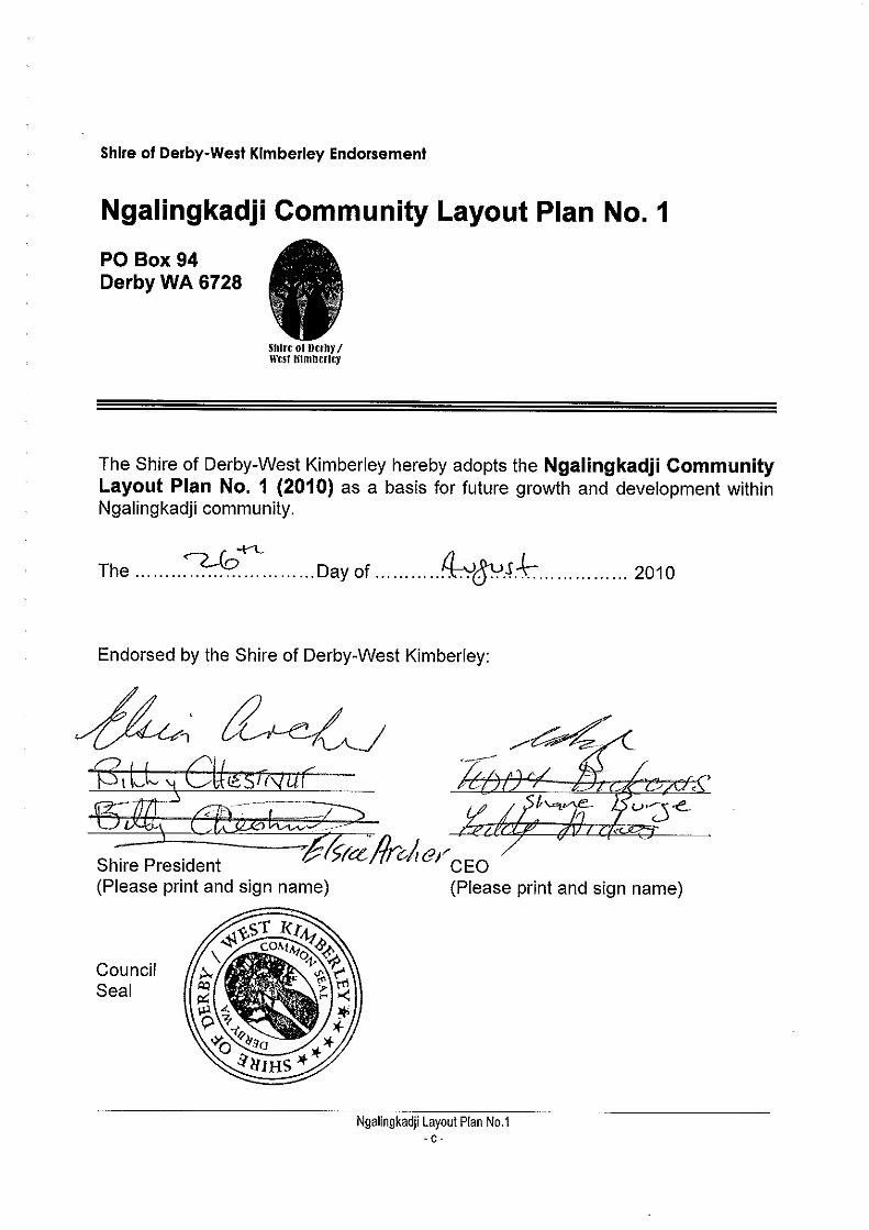
NGALINGKADJI COMMUNITY COUNCIL ENDORSEMENT ........................................................................... A KIMBERLEY LAND COUNCIL ENDORSEMENT ............................................................................................ B SHIRE OF DERBY-WEST KIMBERLEY ENDORSEMENT ................................................................................... C WESTERN AUSTRALIAN PLANNING COMMISSION ENDORSEMENT ............................................................... D
REFERENCES & INFORMATION ....................................................................................................... E
APPENDICES .................................................................................................................................. F
Appendix 1 Record of Certificate of Crown Land Title
Appendix 2 Registered Aboriginal Heritage Sites
proximate to Ngalingkadji
_________________________________________________________________________________________________________ Ngalingkadji Layout Plan No.1
- i -
CONTACTS
COMMUNITY CONTACTS
Name Ngalingkadji Aboriginal Corporation
Related Organisations Marra Worra Worra Aboriginal Corporation
Essential Services Billy Chestnut / Peter Murray (based in Djugerari)
Tel 9191 7165
Chairperson / Coordinator Topsy Chestnut
Tel - Office 9191 7165
Fax 9191 7165
Postal Address PO Box 5 Fitzroy Crossing 6765
Email n/a
AGENCY CONTACTS
SERVICE CONTACT PEOPLE
Shire of Derby/West Kimberley
Environmental Health Officer Emma Catlin Tel: 9191 0955 Fax: 9191 0997
Mobile: 0429 880 833 [email protected]
Town Planner Noel Myers. Tel: 9443 8273
Department of Housing
Housing David Carpenter. Tel: 9222 4817
Essential Services Graham McCafferty. Tel: 9222 4818 Fax: 9222 8137
Parsons Brinckerhoff
Essential Services Program Julia Carpenter. Tel: 9489 9700
Kimberley Regional Service Providers
Essential Services Program
[Broome office] Rob Imber Tel: 9192 1641. / 0409 915 152
Marra Worra Worra
CDEP / Training Programs Karen Worth, Tel: 9191 5089
Department of Planning
Town Planning / Layout Plans Simon Davis. Tel: 9264 7632
Main Switchboard [Perth] 9264 7777
Dept. Regional Development & Lands
Pastoral Lands [Perth Office] Kael Eringa. Tel: 9347 5129 [email protected]
Land ownership issues (Kununurra
office)
Peter Broekmeulen. Tel: 9168 0621
_________________________________________________________________________________________________________ Ngalingkadji Layout Plan No.1
- ii -
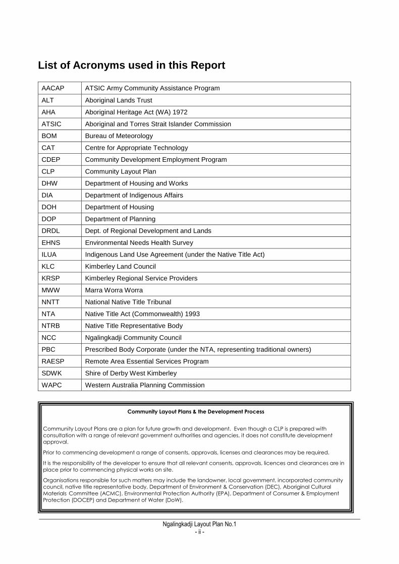
List of Acronyms used in this Report
AACAP ATSIC Army Community Assistance Program
ALT Aboriginal Lands Trust
AHA Aboriginal Heritage Act (WA) 1972
ATSIC Aboriginal and Torres Strait Islander Commission
BOM Bureau of Meteorology
CAT Centre for Appropriate Technology
CDEP Community Development Employment Program
CLP Community Layout Plan
DHW Department of Housing and Works
DIA Department of Indigenous Affairs
DOH Department of Housing
DOP Department of Planning
DRDL Dept. of Regional Development and Lands
EHNS Environmental Needs Health Survey
ILUA Indigenous Land Use Agreement (under the Native Title Act)
KLC Kimberley Land Council
KRSP Kimberley Regional Service Providers
MWW Marra Worra Worra
NNTT National Native Title Tribunal
NTA Native Title Act (Commonwealth) 1993
NTRB Native Title Representative Body
NCC Ngalingkadji Community Council
PBC Prescribed Body Corporate (under the NTA, representing traditional owners)
RAESP Remote Area Essential Services Program
SDWK Shire of Derby West Kimberley
WAPC Western Australia Planning Commission
Community Layout Plans & the Development Process
Community Layout Plans are a plan for future growth and development. Even though a CLP is prepared with
consultation with a range of relevant government authorities and agencies, it does not constitute development
approval.
Prior to commencing development a range of consents, approvals, licenses and clearances may be required.
It is the responsibility of the developer to ensure that all relevant consents, approvals, licences and clearances are in
place prior to commencing physical works on site.
Organisations responsible for such matters may include the landowner, local government, incorporated community
council, native title representative body, Department of Environment & Conservation (DEC), Aboriginal Cultural
Materials Committee (ACMC), Environmental Protection Authority (EPA), Department of Consumer & Employment
Protection (DOCEP) and Department of Water (DoW).
_________________________________________________________________________________________________________ Ngalingkadji Layout Plan No.1
- iii -
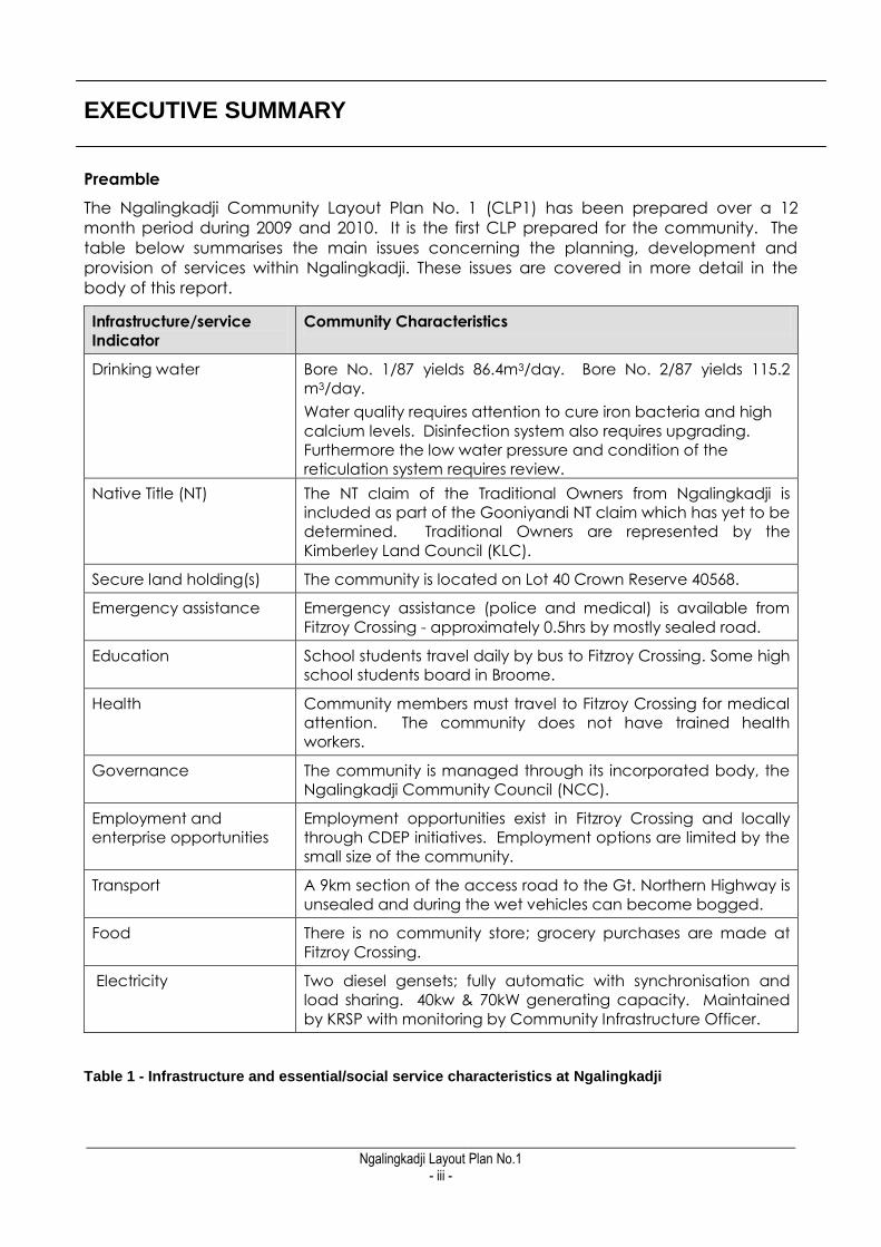
EXECUTIVE SUMMARY
Preamble
The Ngalingkadji Community Layout Plan No. 1 (CLP1) has been prepared over a 12
month period during 2009 and 2010. It is the first CLP prepared for the community. The
table below summarises the main issues concerning the planning, development and
provision of services within Ngalingkadji. These issues are covered in more detail in the
body of this report.
Infrastructure/service
Indicator
Community Characteristics
Drinking water Bore No. 1/87 yields 86.4m3/day. Bore No. 2/87 yields 115.2
m3/day.
Water quality requires attention to cure iron bacteria and high
calcium levels. Disinfection system also requires upgrading.
Furthermore the low water pressure and condition of the
reticulation system requires review.
Native Title (NT) The NT claim of the Traditional Owners from Ngalingkadji is
included as part of the Gooniyandi NT claim which has yet to be
determined. Traditional Owners are represented by the
Kimberley Land Council (KLC).
Secure land holding(s) The community is located on Lot 40 Crown Reserve 40568.
Emergency assistance Emergency assistance (police and medical) is available from
Fitzroy Crossing - approximately 0.5hrs by mostly sealed road.
Education School students travel daily by bus to Fitzroy Crossing. Some high
school students board in Broome.
Health Community members must travel to Fitzroy Crossing for medical
attention. The community does not have trained health
workers.
Governance The community is managed through its incorporated body, the
Ngalingkadji Community Council (NCC).
Employment and
enterprise opportunities
Employment opportunities exist in Fitzroy Crossing and locally
through CDEP initiatives. Employment options are limited by the
small size of the community.
Transport A 9km section of the access road to the Gt. Northern Highway is
unsealed and during the wet vehicles can become bogged.
Food There is no community store; grocery purchases are made at
Fitzroy Crossing.
Electricity Two diesel gensets; fully automatic with synchronisation and
load sharing. 40kw & 70kW generating capacity. Maintained
by KRSP with monitoring by Community Infrastructure Officer.
Table 1 - Infrastructure and essential/social service characteristics at Ngalingkadji

_________________________________________________________________________________________________________ Ngalingkadji Layout Plan No.1
- iv -
CLP No. 1 plans for future expansion of the community, formalises existing infrastructure
and land-uses and provides a future lot layout and road design. The major purpose of the
CLP is to guide the growth and development of Ngalingkadji by providing a layout of
future land uses in the community.
The CLP addresses future growth issues in the context of constraints to development
including the poor quality of the water supply and potential for contamination, limited
existing community facilities, and problems with dust and with the access road to Great
Northern Highway.
The CLP has been prepared in consultation with the Ngalingkadji Community Council
(NCC) to ensure that the plan reflects the community's aspirations. Technical input from a
number of government and non-government agencies responsible for providing services
and infrastructure to the community has also been incorporated into the plan and this
report.
This Community Layout Plan outlines a clear and straightforward way for Ngalingkadji to
grow in a co-ordinated and efficient manner.
Development at Ngalingkadji
The following initiatives, development and works are needed to implement CLP1:
Within the next year:
1. Implement road naming and lot numbering system. (NCC)
2. Relocate the rubbish pits to Lot 32 south of the community. (MWW)
3. Prepare a Drinking Water Source Protection Plan (DWSPP) for Ngalingkadji. (DoH)
4. Upgrade the section of Cherrabun Road to allow for year round access to Great
Northern Highway. (SDWK)
5. Investigate future development of a new multi-purpose centre incorporating
church and youth centre facilities. (NCC)
6. Develop landscaping for the central public open space area. (NCC)
7. Relocate basketball court to central open space area. (NCC)
Within the next 5 years:
1. Develop new water source in accordance with the DWSPP. (DoH)
2. Construct an additional community house on Lot 7. (DHW)
3. Investigate the replacement/upgrade of power station Genset 1. (DHW)
4. Rationalise the internal road layout and seal roads to control dust. (MWW)
5. Construct fencing around the community to control roaming stock and prevent
damage to property. (NCC)
6. Relocation of rubbish tip outside the 500m bore buffer area. (MWW)

_________________________________________________________________________________________________________ Ngalingkadji Layout Plan No.1
- v -
7. Amend crown reserve as indicated on land tenure plan to accommodate future
rubbish tip. (DRDL & DoP)
Within the next 10 years:
1. Construct three additional community houses on Lots 8, 10 and 14 as identified on
the CLP. (DHW)
2. Construct multi-purpose community centre on Lot 26. (NCC)
3. Upgrade power station in accordance with the Community's ongoing
development. (DoH)

_________________________________________________________________________________________________________ Ngalingkadji Layout Plan No.1
- 1 -
1 BACKGROUND
1.1 Location & Physical Geography Ngalingkadji is located within the Kimberley area of Western Australia. It is located SE from
Fitzroy Crossing; 54kms by the sealed Great Northern Highway and 9kms by the unsealed
Cherrabun Road. During the wet season the unsealed section of road near the entrance
to the community intermittently becomes unusable due to flooding and bogging.
The community is located within the Shire of Derby/West Kimberley; the administrative
centre of the Shire is located in Derby which is approximately 3.5 hours by road from the
community.
Ngalingkadji is within the South Fitzroy Floodplain physiographic region. The South Fitzroy
Plains include the dissected anticlinal highlands of the St George Ranges and Poole
Range (up to 190 m above plain level) and are largely rubble covered. (Lindsay and
Commander, 2006).
The principle major wet season watercourse in the area is Christmas Creek which feeds
into the Fitzroy River. A number of smaller watercourses, including Nipper Creek, are in
close proximity to the community. The area is relatively flat and contains the pindan soils
which are typical of the Kimberley. Low lying areas outside the community contain
reactive black soils.
The flora in the transitional zone between the desert to the south and the wetter monsoon
forests of the north Kimberley consist of mainly grassland and savanna vegetation types.
Figure 1 - Location of Ngalingkadji

_________________________________________________________________________________________________________ Ngalingkadji Layout Plan No.1
- 2 -
1.2 Ngalingkadji Climate
The Bureau of Meteorology identifies Ngalingkadji as being within a subtropical climate
region; being arid with mainly summer rains. The wet season usually from November to
April and has high humidity and frequent thunderstorms, often resulting in the flooding of
river systems of the Fitzroy Valley and its tributaries.
High-intensity rainfall resulting from cyclonic activity from the north and northwest and
localised thunderstorms usually occur between this period followed by winters with little or
no rainfall. Rainfall is highly variable, ranging from less than 180mm/mth in the wet season
to less than 5mm/mth in the dry season.
The average maximum temperature exceeds 35° C.
The dry season usually extends from May to October and has an average maximum
temperature of 30° C with prevailing winds at this time from the east, which can blow dust
from the dry, sandy interior toward the community and presents the community with
community with a number of issues.
The BOM does not have specific climate data for Ngalingkadji. The nearest location with
recorded climate data is Cadjebut a field data station located on the Great Northern
Highway approximately 26kms north of Ngalingkadji. Figures 2 and 3 chart average
maximum temperature and rainfall for Cadjebut.
Figure 2 – Mean Maximum Temperature Figure 3 – Mean Rainfall
1.3 History
Most of the people from the community are part of the Gooniyandi language group from
the Fitzroy Valley region.
Ngalingkadji was established as a permanent Aboriginal community in the early 1980‟s by
Gooniyandi people moving from Gogo Pastoral Station where many of the men had
worked as stockmen. The community became incorporated in 1983.
_________________________________________________________________________________________________________ Ngalingkadji Layout Plan No.1
- 3 -
The establishment of Ngalingkadji can generally be seen as part of the broader
„Homelands‟ movement that began in Western Australia in the late 1970s, which saw the
permanent return to traditional country of Aboriginal peoples who had previously
migrated to government institutions, missions, ration stations, pastoral stations and town
camps.
1.4 CLP Status
This is the first CLP to be prepared for the Ngalingkadji Community. An „as constructed
plan‟ also exists and includes the current details of infrastructure and community buildings
including dwellings, workshops and offices.
_________________________________________________________________________________________________________ Ngalingkadji Layout Plan No.1
- 4 -
2. EXISTING SITUATION
2.1 Governance
The community is managed through its incorporated body, the Ngalingkadji Community
Council (NCC). The NCC was incorporated under the Aboriginal Councils and
Associations Act 1976 in June 1987.
Community members elect a Community Council each year. A Chairperson is elected at
the Council‟s Annual General Meeting. The Council meets once a month and as matters
arise that require attention.
Documents for the Ngalingkadji Aboriginal Corporation can be found on the website for
the Office of the Register of Indigenous Corporations (www.oric.gov.au).
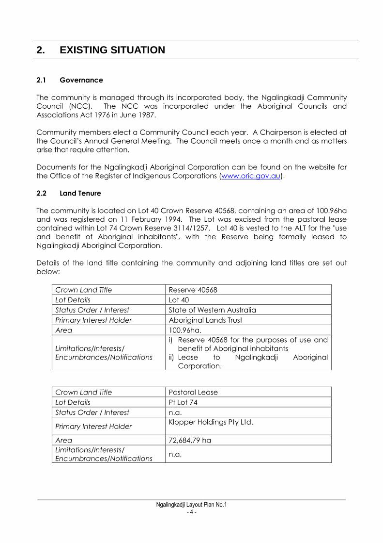
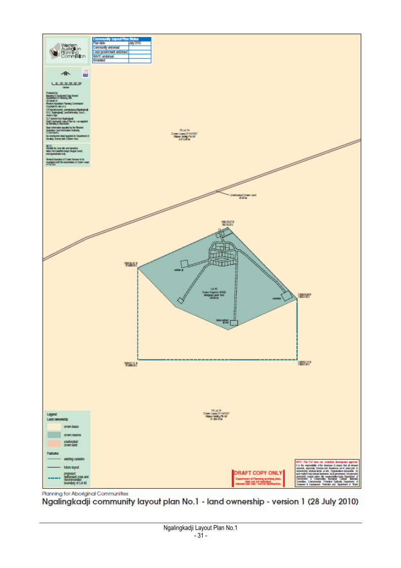
2.2 Land Tenure
The community is located on Lot 40 Crown Reserve 40568, containing an area of 100.96ha
and was registered on 11 February 1994. The Lot was excised from the pastoral lease
contained within Lot 74 Crown Reserve 3114/1257. Lot 40 is vested to the ALT for the "use
and benefit of Aboriginal inhabitants", with the Reserve being formally leased to
Ngalingkadji Aboriginal Corporation.
Details of the land title containing the community and adjoining land titles are set out
below:
Crown Land Title Reserve 40568
Lot Details Lot 40
Status Order / Interest State of Western Australia
Primary Interest Holder Aboriginal Lands Trust
Area 100.96ha.
Limitations/Interests/
Encumbrances/Notifications
i) Reserve 40568 for the purposes of use and
benefit of Aboriginal inhabitants
ii) Lease to Ngalingkadji Aboriginal
Corporation.
Crown Land Title Pastoral Lease
Lot Details Pt Lot 74
Status Order / Interest n.a.
Primary Interest Holder Klopper Holdings Pty Ltd.
Area 72,684.79 ha
Limitations/Interests/
Encumbrances/Notifications n.a,

_________________________________________________________________________________________________________ Ngalingkadji Layout Plan No.1
- 5 -
Figure 4. Land Tenure
Pastoral Lease
Crown Reserve 40568 is surrounded by a 72,684.79 ha pastoral lease; Lot 74 Crown Lease
3114/1257 which is leased to Klopper holding Pty Ltd.
Unallocated Crown Land
Unallocated Crown Land with an area of 32.32ha and containing Cherrabun Road is
located to the north of Crown Reserve 40568.
The Record of Certificate for the Crown Land Titles is included in Appendix 2.
_________________________________________________________________________________________________________ Ngalingkadji Layout Plan No.1
- 6 -
2.3 Native Title
The Traditional Owners of the land within which the community is located on are
represented by the Kimberley Land Council (KLC). The NT claim of the Traditional Owners
from Ngalingkadji is included as part of the Gooniyandi NT claim (WC 00/10) for which a
draft consent determination has been made. Traditional Owners are represented by the
Kimberley Land Council (KLC).
There is no registered ILUA covering the Ngalingkadji community or surrounding area.
2.4 Culture
Most members of the Ngalingkadji community are part of the Gooniyandi
cultural/language group. The community has a relatively small permanent population
and many of the residents are related, there are no separate living areas within the
community for different language groups.
Background to Native Title in Australia
The Native Title Act 1993 (NTA) enshrines in legislation the High Court Mabo decision, in which the
common law of Australia formally recognised Indigenous land ownership through the continuing
observance of traditional law and custom. Native title is defined by section 223 of the NTA as:
the communal, group or individual rights and interests of Aboriginal people or Torres Strait Islanders
in relation to land or waters where:
the rights and interests are possessed under the traditional laws acknowledged, and the traditional
customs observed, by the Aboriginal people or Torres Strait islanders; and b) the Aboriginal people
or Torres Strait Islanders, by those laws and customs, have a connection with the land and waters;
and c) the rights and interests are recognised by the common law of Australia.
Native title is therefore not a form of land tenure, such as a freehold estate or pastoral lease, but is
the recognition of pre-existing rights and interests in country.
Under the NTA, registered native title claimants and registered native title bodies corporate (often
referred to as PBCs) are entitled to the right to negotiate regarding proposed future acts which
may affect native title rights and interests. Procedures for negotiation can either be in
accordance with Subdivision J of the NTA or in accordance with alternative procedures agreed by
both parties in the form of an Indigenous Land Use Agreement (ILUA). Examples of future acts
which may affect native title rights and interests include mining exploration or the construction of
public works (such public housing).
Native title rights and interests are also variously affected by different forms of land tenure. For
example, native title rights and interests are generally extinguished by valid grants of freehold
tenure (see Division 2B of the NTA and also Ward and Lawson decisions) while native title may co-
exist with pastoral leases, but if there is any inconsistency between the two then pastoral interests
are likely to prevail (see Wik decision). Additionally, ILUAs can be entered into so that agreement
can be made about instances when the non-extinguishment principle applies. More information
about native title can be obtained from the National Native Title Tribunal.

_________________________________________________________________________________________________________ Ngalingkadji Layout Plan No.1
- 7 -
The people who originally established the community were previously living at Gogo
Station. A number of the traditional owners of the area live at the community; others have
relocated to Fitzroy crossing to be closer to medical and other services.
Community administration and infrastructure maintenance are undertaken by members
of the Ngalingkadji Community Council.
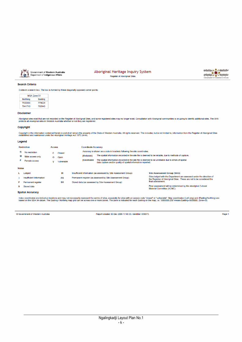
2.5 Aboriginal Heritage
Notwithstanding the above, the following discussion of heritage matters derives from
consultation with the community and a desk-top survey of sites registered under the AHA
1972 using the Aboriginal Heritage Inquiry System.
The purpose of the following discussion is to foreshadow heritage constraints to
development as they relate to the implementation of the CLP. These constraints to
development must be addressed prior to construction of housing and other works.
Heritage / No-Go Area
There are no cultural „no go‟ areas within the immediate community living area.
Registered Sites
Impact of Aboriginal Heritage on Urban Growth in Remote Aboriginal Communities
The Aboriginal Heritage Act 1972 (AHA) was introduced in Western Australia to provide automatic
protection for all places and objects in the State that are important to Aboriginal people because
of connections to their culture. The Department of Indigenous Affairs maintains a Register of
Aboriginal Sites as a record of places and objects of significance to which the AHA applies. It
should be noted that unregistered sites of cultural significance to Aboriginal people are also
protected under the State Government‟s Aboriginal Heritage Act 1972, but only registered sites
are recorded on the Department's database and are generally included in the Aboriginal
Heritage Inquiry System.
The presence of an Aboriginal site places restrictions on what can be done to the land. Under the
AHA it is an offence for anyone to excavate, damage, destroy, conceal or in any way alter
an Aboriginal site without obtaining the appropriate approvals. Anyone who wants to use land for
development or any other cause must therefore investigate whether there is an Aboriginal
heritage site on the land.
Contact should be made with the relevant Native Title Representative Body in the first instance.
No formal heritage assessment under the Aboriginal Heritage Act 1972 has been undertaken as
part of the preparation of CLP No. 1 and the CLP Background Report and CLP map-set do not
represent clearance under that Act in any way. It is expected that any future development of
housing and other infrastructure on the community be undertaken in consultation with the
community and native title holders and cleared in accordance with the provisions of the AHA.
_________________________________________________________________________________________________________ Ngalingkadji Layout Plan No.1
- 8 -
The community living area of Ngalingkadji is located within a site of cultural significance
which is on the Register of Aboriginal Sites for Western Australia. It should be noted that
both registered and unregistered sites of cultural significance to Aboriginal people are
protected under the State Government‟s Aboriginal Heritage Act 1972, but only registered
sites are recorded on the Department of Indigenous Affairs‟ database.
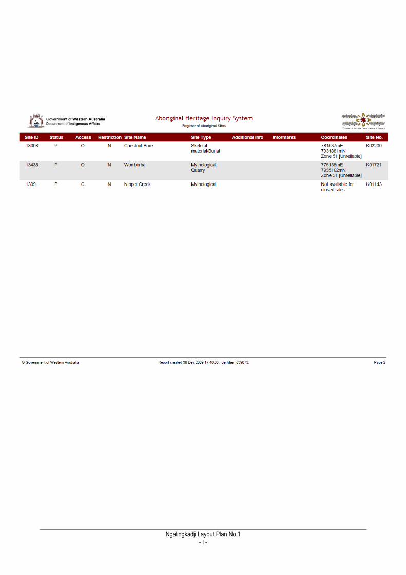
The formally identified site, Nipper Creek (site No. K01143) is recognised as a mythological
site and runs for approximately 45kms, following Nipper Creek. The creek itself is located
approximately 2kms SW of Ngalingkadji, and therefore considered well outside of the
community's future development area. (See Appendix 3 for details of registered site
search).
Traditional Owners should be consulted prior to the commencement of any housing or
infrastructure development at the community to ensure compliance with the Aboriginal
Heritage Act. It is beyond the scope of this CLP to identify the relevant traditional owners
for such consultation. Government agencies should contact the community and the
Kimberley Land Council in this regard.
2.6 Population Current Population
Estimating and predicting populations in Aboriginal communities is difficult because
Aboriginal people tend to be mobile in terms of housing and living arrangements.
Population based on family, cultural or administrative factors (see Taylor 2006 for a useful
discussion of demographic trends of remote Indigenous populations).
The community members of Ngalingkadji have close affiliations with other settlements in
the region including Broome, Fitzroy Crossing, Wangkatjungka, Yakanarra and Djugerari.
Population figures also vary depending on the time of year of enumeration, methods and
sources by which data are collected. The population of the community is under the
minimum size for which the Australian Bureau of Statistic (ABS) collects data, as such
population information has been collected directly from the community and from the
Environmental Health Needs Surveys undertaken by the Department of Indigenous Affairs.
A summary of recent population data from these two sources follows:
Table 2 - Population figures by source 1997-2010
1997 2004 2009 2010
Total persons 25 46 30 50
Non Indigenous people
0
Indigenous males 22
Indigenous females 28
Source EHNS EHNS EHNS Community
The acting community chairperson advised in 2010 that current population is
approximately 50 people. The population varies between the wet and dry seasons and in
accordance with cultural, family and work commitments elsewhere.
_________________________________________________________________________________________________________ Ngalingkadji Layout Plan No.1
- 9 -
Based on the above, this report assumes that the usual permanent population of the
community is 45 residents, it is noted that there are no non-Indigenous staff members living
in the community.
Design Population & Estimated Housing Demand
The population of the community has fluctuated in recent years. Road access to Fitzroy
Crossing is good and travelling time is approximately half an hour, mostly by sealed road,
meaning that facilities and services in the town are within relatively easy access to the
community.
The factors that may reduce population growth at the community include the lack of a
store and school facilities, no medical staff or facilities and limited employment
opportunities.
Community members have stated that the houses are not overcrowded. While there is a
desire to have provision for future housing there is no urgent need for additional housing at
this time.
The Fitzroy Futures Town Plan (WAPC 2005) estimates a five per cent annual growth rate for
communities in Fitzroy Crossing while the population projections for the Shire of Derby/West
Kimberley indicate a 5-6 per cent growth rate to 2016, and a five per cent annual growth
rate has been estimated for Fitzroy Crossing.
The estimated design population over a 15-year period, based on a current population of
45 and an annual growth rate of 2 per cent, is 49 by 2014 (5 years), 54 residents by 2019
(10 years) and 59 residents by 2024 (15 years).
The table below outlines the estimated population growth over the next fifteen years with
a constant annual growth of 2% per year. It is likely however that the population growth
will not be constant over that period of time, and will be contingent on migration to and
from the community as well as natural increase from births and deaths.
There are currently 13 dwellings within the community. It is estimated that to maintain the
average current household density of 3.5 people that 4 new houses will have to be
constructed by 2024, each requiring a new residential lot.
The actual population density per house will vary depending on a number of factors
including extended-family obligations, household composition (number of adults and
children living in the same house) and the number of bedrooms in the house.
Furthermore the existing poor water quality in Ngalingkadji and uncertainty over a future
source of a sustainable supply of good quality water acts to constrain expectations on the
future growth of the community.

_________________________________________________________________________________________________________ Ngalingkadji Layout Plan No.1
- 10 -
Table 3 - Demand for additional housing assuming 2% population growth 2010-2024
Year Population estimate
(growth @ 2% p.a)
Housing density
based on 13
existing houses (ie
no additional
houses)
No. additional
houses needed
to maintain
existing housing
density (3.5
persons /house)
Total housing
stock needed
(excluding
staff housing)
2010 45 3.5 0 13
2011 47 3.6 0 13
2012 47 3.6 0 13
2013 48 3.7 1 14
2014 49 3.8 0 14
2015 50 3.8 0 14
2016 51 3.9 1 15
2017 52 4.8 0 15
2018 53 4.1 0 15
2019 54 4.2 0 15
2020 55 4.2 1 16
2021 56 4.3 0 16
2022 57 4.4 0 16
2023 58 4.5 1 17
2024 59 4.5 0 17
2.7 Housing
Residential Areas
The living area is located approximately 250m from Cherrabun Road within a relatively flat
locality; the site slopes gently to the south east. The housing is clustered together within
two adjacent sections of unpaved road; the dwellings are separated by a small area of
public open space containing some basic recreation facilities. This CLP makes only minor
modifications to the existing arrangement.
There are no administrative staff or other non-community members living in the
community. All dwellings in the community are rented from the Department of Housing.
Number, Type and Quality of dwellings
There are 13 houses within the community. All the dwellings are constructed of
corrugated iron with steel frames and are built on concrete pads. The houses have four
bedrooms with the exception of two which have two bedrooms. All the housing is
occupied and is not considered overcrowded.
_________________________________________________________________________________________________________ Ngalingkadji Layout Plan No.1
- 11 -
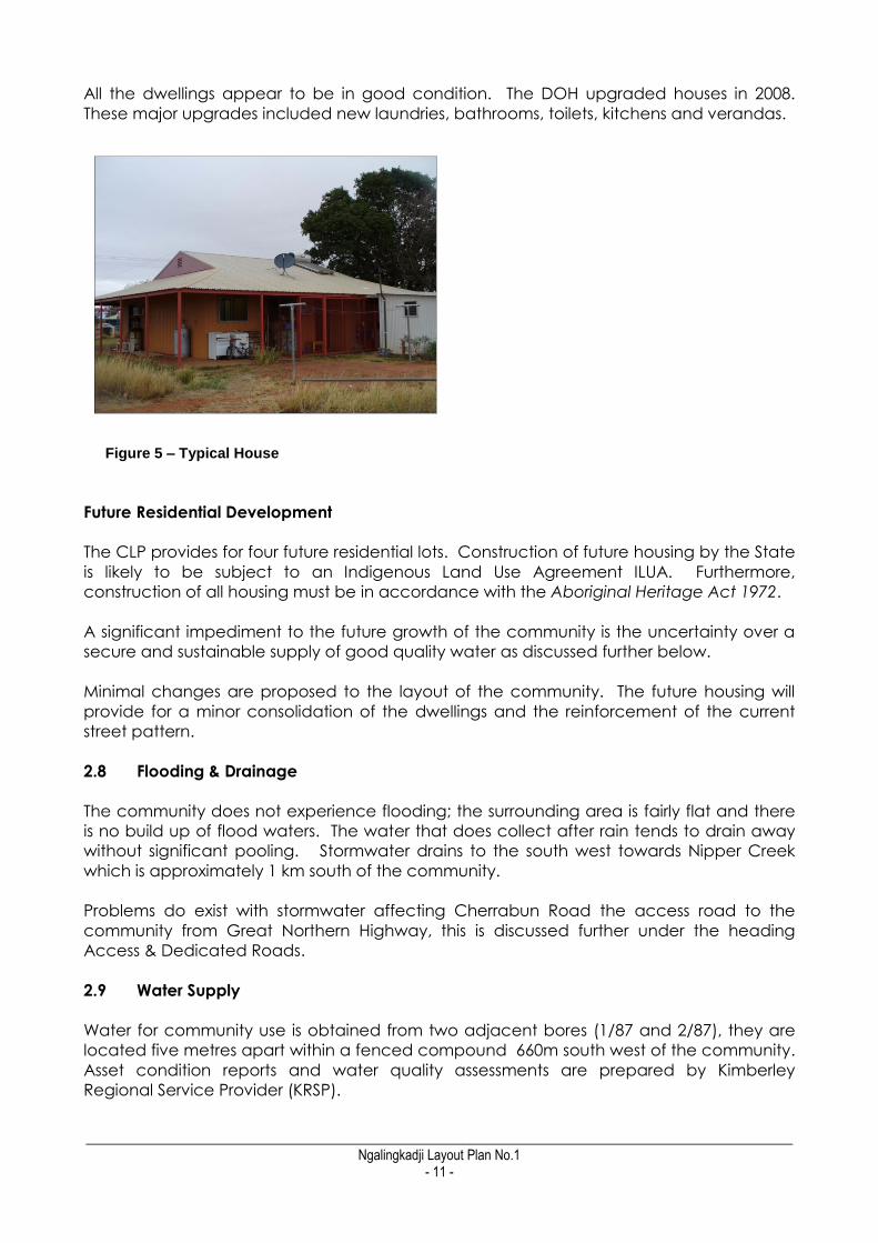
All the dwellings appear to be in good condition. The DOH upgraded houses in 2008.
These major upgrades included new laundries, bathrooms, toilets, kitchens and verandas.
Future Residential Development
The CLP provides for four future residential lots. Construction of future housing by the State
is likely to be subject to an Indigenous Land Use Agreement ILUA. Furthermore,
construction of all housing must be in accordance with the Aboriginal Heritage Act 1972.
A significant impediment to the future growth of the community is the uncertainty over a
secure and sustainable supply of good quality water as discussed further below.
Minimal changes are proposed to the layout of the community. The future housing will
provide for a minor consolidation of the dwellings and the reinforcement of the current
street pattern.
2.8 Flooding & Drainage
The community does not experience flooding; the surrounding area is fairly flat and there
is no build up of flood waters. The water that does collect after rain tends to drain away
without significant pooling. Stormwater drains to the south west towards Nipper Creek
which is approximately 1 km south of the community.
Problems do exist with stormwater affecting Cherrabun Road the access road to the
community from Great Northern Highway, this is discussed further under the heading
Access & Dedicated Roads.
2.9 Water Supply
Water for community use is obtained from two adjacent bores (1/87 and 2/87), they are
located five metres apart within a fenced compound 660m south west of the community.
Asset condition reports and water quality assessments are prepared by Kimberley
Regional Service Provider (KRSP).
Figure 5 – Typical House
_________________________________________________________________________________________________________ Ngalingkadji Layout Plan No.1
- 12 -
KRSP report dated 2006/07 advises that both the bores are producing brackish water with
salinity levels of 670mg/L. It is reported that water quality requires urgent attention to cure
iron bacteria and high calcium levels, also the disinfectant system requires upgrading and
the low water pressure and condition of the reticulation requires urgent review. KRSP
advises that funding is not currently allocated to undertake these works. KRSP report that
water quality during 11 out of 31 months sampled between Dec 07 – Aug 09 were not
compliant with Australian Drinking Water Guidelines.
It was reported that a new bore is proposed for the community but funding is yet to be
approved. No Drinking Water Source Protection Assessment or Plan has been prepared
for the community to date.
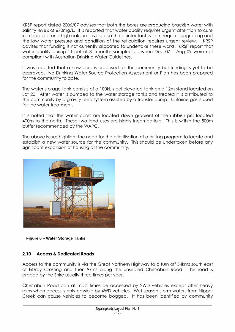
The water storage tank consists of a 100kL steel elevated tank on a 12m stand located on
Lot 20. After water is pumped to the water storage tanks and treated it is distributed to
the community by a gravity feed system assisted by a transfer pump. Chlorine gas is used
for the water treatment.
It is noted that the water bores are located down gradient of the rubbish pits located
400m to the north. These two land uses are highly incompatible. This is within the 500m
buffer recommended by the WAPC.
The above issues highlight the need for the prioritisation of a drilling program to locate and
establish a new water source for the community. This should be undertaken before any
significant expansion of housing at the community.
2.10 Access & Dedicated Roads
Access to the community is via the Great Northern Highway to a turn off 54kms south east
of Fitzroy Crossing and then 9kms along the unsealed Cherrabun Road. The road is
graded by the Shire usually three times per year.
Cherrabun Road can at most times be accessed by 2WD vehicles except after heavy
rains when access is only possible by 4WD vehicles. Wet season storm waters from Nipper
Creek can cause vehicles to become bogged. It has been identified by community
Figure 6 – Water Storage Tanks

_________________________________________________________________________________________________________ Ngalingkadji Layout Plan No.1
- 13 -
members that additional road gravel in this locality would assist with vehicle movements
during the wet and help reduce dust.
The Shire advises that preliminary investigations are being carried out on the possibility of
upgrading Cherrabun Road.
2.11 Internal Road Layout
The houses and other buildings within the community are located adjacent to a small
network of connected local roads. The roads are graded but have not been formally
constructed and have no drainage network. The community is located on a gently
sloping site and this assists with stormwater runoff without significant damage to the road
network.
Figure 7 – Shire improvements to Cherrabun Road
Figure 8 – Internal road and central recreation area
_________________________________________________________________________________________________________ Ngalingkadji Layout Plan No.1
- 14 -
The internal road and access roads not being sealed are a source of dust however they
are not heavily trafficked; the community has not identified this as a significant concern.
2.12 Community and Social Services
The following community facilities and social services are located at the community:
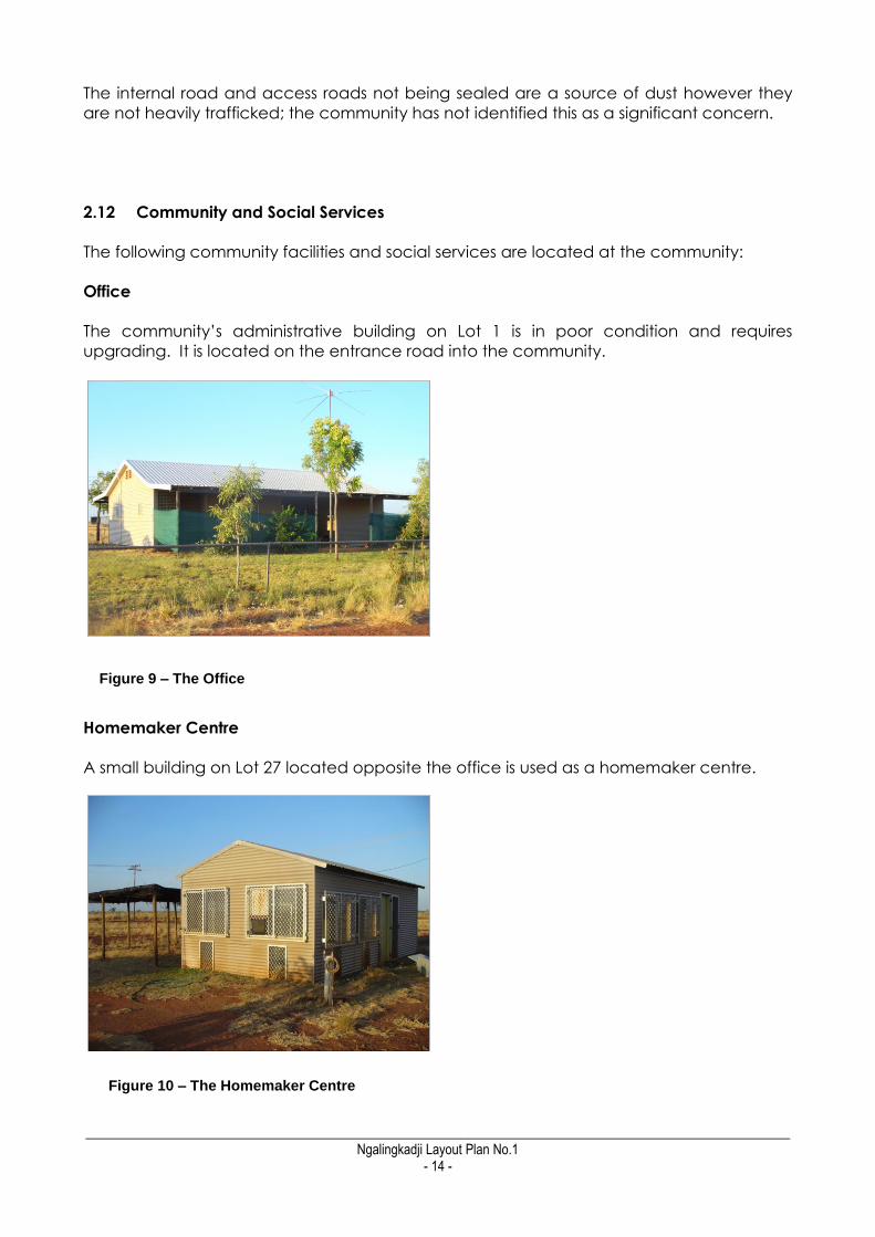
Office
The community‟s administrative building on Lot 1 is in poor condition and requires
upgrading. It is located on the entrance road into the community.
Homemaker Centre
A small building on Lot 27 located opposite the office is used as a homemaker centre.
Figure 9 – The Office
Figure 10 – The Homemaker Centre

_________________________________________________________________________________________________________ Ngalingkadji Layout Plan No.1
- 15 -
Workshop
A workshop exists at the community on Lot 22 however the building is not equipped with
any mechanical equipment.
Recreation Facilities
There is no recreation centre or football oval in the community. Public recreation facilities
are limited to a basketball court on the NW edge of the community and swings with a
shade structure which are located in the central open space area.
Store
There is no store in the community. A building previously used as the store exists but it is in
poor condition and not in use. Community members must travel to Fitzroy Crossing for
regular grocery supplies. A desire has been expressed for a small store to be established in
the community that would stock a small number of essential items. The shed located on
Lot 25 may be converted in for this purpose.
School
There is no school in the community. Students are taken by bus each day to school in
Fitzroy Crossing. Some secondary school students go to boarding school in Broome to
continue their studies.
Clinic
There is no clinic in the community. Community members travel to Fitzroy Crossing for
regular medical treatment.
Cemetery
Figure 11 – The old Store

_________________________________________________________________________________________________________ Ngalingkadji Layout Plan No.1
- 16 -
The cemetery is located within a fenced area in the SE corner of the community‟s Crown
Reserve. The site is approximately one kilometre away from the nearest housing site.
2.13 Electricity Supply
Present Capacity & Location
The two diesel power generators are located at Lot 21 which is 80m north west of the
office and 200m north of the nearest house adjacent to the entrance to the community.
This location is consistent with the recommended buffer distance contained in the draft
Planning for Aboriginal Communities Project Guidelines No.3 – Land Use Buffers (Draft
Guideline No 3). The generators are located within a fenced compound which also
accommodates a 27,000 litre raised fuel tank.
Refuelling trucks have adequate access to the diesel tank and there are no safety issues
with regards to manoeuvring for refuelling trucks.
KRSP is responsible for servicing and fuelling of the power station and carries out
inspections once a month. The Marra Worra Worra Essential Services officer based in
Djugerari is responsible for day to day maintenance and monitoring. The KRSP Asset
Condition Report from its inspection of 2006/2007 identifies power Genset 1 (40kW) as
being in poor condition and in need of replacement. Genset 2 (70kW) is identified as
being in good condition. Above ground power reticulation consists of a network of low
voltage power lines.
The Essential Services officer reports that power from the generators is adequate. Any
increase in housing stock would require a review and possibly an upgrade to the power
generators.
2.14 Wastewater
Houses are connected to individual septic tanks attached to each dwelling; the septic
tanks are emptied once a year. The community members report that they do not have
problems with the wastewater disposal system. There are no sewerage ponds.
Figure 12– The Diesel Power Generators
_________________________________________________________________________________________________________ Ngalingkadji Layout Plan No.1
- 17 -
The septic tanks are located outside the 500m buffer area of the two water bores however
they are directly upstream of the bores. It has been noted previously that these bores
have water quality problems, their general proximity to the septic tanks provides a further
reason to find an alternative source of water supply for the community.
2.15 Rubbish Disposal
The rubbish disposal site is located 300m west of the nearest dwellings and 400m north of
the water bores, access is via a graded track. No sorting of rubbish is undertaken; all
domestic waste is disposed of in an open pit which is approximately 3.0m deep. The
rubbish pit is contained within an unlocked fenced compound.
Rubbish collection and disposal is organised by the Marra Worra Worra Essential Services
Officer. The rubbish tip is maintained by the Centre for Appropriate Technology (CAT)
which is based in Derby. The tip was upgraded in late 2009.
Draft Guideline No. 3 recommends a generic buffer of 2000m for rubbish tips. The
community‟s crown lease is not of a sufficient size to achieve this buffer however a
relocation of the rubbish tip to the south east boundary of the lease will address concerns
regards water supply contamination until a new water source is identified.
2.16 Airstrip
There is no airstrip at Ngalingkadji.
2.17 Outstations
There are no outstations associated with Ngalingkadji.
_________________________________________________________________________________________________________ Ngalingkadji Layout Plan No.1
- 18 -
3. PLANNING FRAMEWORK
3.1 State Planning Policies
State Planning Policies (SPPs) are prepared and adopted by the WAPC under statutory
procedures set out in section 26 of the Planning and Development Act 2005.
The WAPC and local governments must have 'due regard' to the provisions of State
Planning Policies when preparing or amending town planning schemes and when making
decisions on planning matters. The State Administrative Tribunal is also required to take
account of SPPs when determining appeals.
The following SPPs were given due regard in the preparation of the CLP:
SPP 3 – Urban Growth and Management;
SPP3.2 Planning for Aboriginal Communities; and
SPP2.7 Public Drinking Water Source
3.2 Land Use Buffers for Aboriginal Communities
In 2007, consultants Arup prepared the draft „Land Use Buffers for Aboriginal Communities
in Western Australia‟ report on behalf of the Department for Planning & Infrastructure (DPI).
The report defines minimum separation distance buffers specifically suited to the range,
scale and type of infrastructure typical of remote Aboriginal communities. All buffers
specified in this CLP are based on that report.
3.3 Shire of Derby-West Kimberley Town Planning Scheme No. 5
The Shire of Derby-West Kimberley Town Planning Scheme No. 5 (TPS 5) was gazetted on
25 September 2001. The community is not located within the area covered by the
Scheme Map, meaning that land use and development in the community has historically
been unregulated. Under the Scheme, Planning Approval is not required prior to new
development or a change in land use, although a Building Licence is generally required.
Settlement Zone
TPS5 includes provision for a Settlement Zone to accommodate remote Aboriginal
communities. At the present time the land containing Ngalingkadji is not zoned under
TPS5.
The objectives of the Settlement Zone are:
(a) To achieve the orderly and proper planning of Aboriginal Communities through
the preparation and adoption of Community Layout Plans.
(b) To provide a framework for the planning of Communities and also to provide a
basis for negotiation between the Council and Aboriginal Communities on the
development of co-operative strategies to improve the general health, safety and
amenity of these communities.

_________________________________________________________________________________________________________ Ngalingkadji Layout Plan No.1
- 19 -
The Settlement Zone also includes the following policies:
(i) To require development to be consistent with a Community Layout plan endorsed
by the Community and Council;
(ii) To provide in the Community Layout Plan for a mix of land uses on the one lot
which may include residential, community, administration, rural, and health, and
small business activities for the support of the community, where these are consistent
with the enhancement of the residential amenity in the locality;
(iii) To ensure that services and community infrastructure is provided in conjunction
with development of land within the zone and consistent with an adopted Layout
Plan.
The Ngalingkadji CLP provides for all community buildings, facilities and infrastructure to be
in included within a Settlement Zone which is identified on the CLP plans.

_________________________________________________________________________________________________________ Ngalingkadji Layout Plan No.1
- 20 -
4. COMMUNITY ASPIRATIONS
Providing a sufficient standard of living for the current population of Ngalingkadji and
future residents is dependent on maintaining and improving the existing facilities and
making sure that there is the right mix of housing and other uses.
There is an understanding that development of the community is something that has
taken time, and will happen over many years.
The ideas for improvements to the facilities noted by the Ngalingkadji Community Council
when developing the Community Layout Plan are listed below (in no particular order).
Due to constraints, not all of the community aspirations can be incorporated into a CLP,
however have been noted as a record of a more general community improvement plan.
It should also be recognised that this plan looks ahead 10 to 15 years and as such a
number of these aspirations will need a significant amount of further discussion and
investigation before they can be developed.
1. Locate and establish a new source of water for the community. The current source
is of poor quality and has raised concerns about possible adverse affect on the
health of community members.
2. Upgrade Cherrabun Road to all weather standard to improve access to Great
Northern Highway during the wet season.
3. The establishment of a multipurpose facility is proposed. The building is to
accommodate meetings, indoor recreation, arts and crafts activities, homemaker
courses and church meetings.
4. There is a desire to have additional housing to accommodate family members
residing in Fitzroy Crossing.
5. Improve the internal road layout and seal roads to control the movement of
vehicles and reduce dust.
6. Upgrade landscaping and fence the central public open space area to prevent
access by stock, improve the amenity of the area and reduce dust.
7. Established a store that would stock a small number of essential items.
8. An extension to the lease to the south is sought to accommodate horse paddocks.

_________________________________________________________________________________________________________ Ngalingkadji Layout Plan No.1
- 21 -
5. TRADITIONAL OWNER ASPIRATIONS
A number of Traditional Owners live at Ngalingkadji and were involved with the
preparation of the Community Layout Plan. The Kimberley Land Council, on behalf of the
Traditional Owners, supports the aspirations of Ngalingkadji Community Council in the
development of the Community Layout Plan. The KLC recognises the importance of the
CLP as a guide for the growth and development of Ngalingkadji by providing a layout of
future land uses in the community.
_________________________________________________________________________________________________________ Ngalingkadji Layout Plan No.1
- 22 -
6. DEVELOPMENT PROJECTS & REQUIRED IMPROVEMENTS
6.1 Design Summary
The future plans for the Ngalingkadji are based on visits to the community and advice
from relevant government agencies, including the Remote Area Essential Services
Program (RAESP) managers Parson Brinkerhoff, the Shire of Derby West Kimberley,
Aboriginal Lands Trust, Main Roads WA, Global Groundwater, and the Departments for
Planning, Housing, Environment and Conservation, Water and Indigenous Affairs.
The general design principles of the plan are:
1. Maintain adequate separation between incompatible uses.
2. Define a road network that is suitable for all uses, including water, electricity and
other services.
3. Plan for future growth by developing new residential lots.
4. Allocate land for a range of land uses that may be needed in the future.
The Ngalingkadji Community Layout Plan No. 1. shows all proposed improvements to
Ngalingkadji, as well as a layout for current and future land uses. The following provides a
brief explanation of the design principles and required improvements that are shown on
the plan.
6.2 Water Supply
There is an urgent need to resolve the water problems at the community. The current
supply is of poor quality and the location of septic tanks, rubbish pit and wrecked motor
vehicle storage area, upstream of the water bores is cause for concern. The rubbish pit
along with a storage area for car bodies are also within the buffer area of the water
bores.
Security of the water supply is fundamental to the future existence of the community. In
the short term the rubbish pit can be re-located to minimise the potential for
contamination and closer monitoring of water quality can be undertaken. It may also be
possible that further treatment of the current water supply can be undertaken to improve
water quality.
Securing the new source of potable water may be more problematic. It is understood
that previous drilling programs have been unsuccessful in finding a source of good quality
water within a reasonable distance of the community. However the initiation of a drilling
program to locate and establish a new water source for the community remains a key
priority. It is apparent that the future source of water may be outside the community‟s
current Crown lease. If this is the case future negotiations may be required to extend the
lease to these to include this site.
Without a secure supply of potable water within reasonable proximity of the community
the future tenure of the community cannot be guaranteed. As such any future

_________________________________________________________________________________________________________ Ngalingkadji Layout Plan No.1
- 23 -
development within the community should be placed on hold until a new water supply is
secured.
6.3 Public Drinking Water Source Area
In order to ensure that the existing drinking water supply is appropriately protected, a
groundwater source protection and management plan should be prepared by the KRSP
in collaboration with MWW.
Such a plan would incorporate monitoring and maintenance requirements, estimates of
groundwater flow directions, estimation of aquifer resources, likely zones of influence of
production bores and an assessment of the potential for contaminants to impact water
supplies.
A Public Drinking Water Source Area (PDWSA), as prescribed by State Planning Policy 2.7 –
Public Drinking Water Source, is considered the most effective way of identifying and
protecting a drinking water source. PDWSAs are defined areas of land within which land
uses are restricted to protect drinking water that is harvested within that area. They are
based on hydrological analysis of the particular circumstances of the water source and
the settlement/s it serves. PDWSAs are enforced through a range of statutory implements.
Preparation of a PDWSA is a priority for the community to ensure appropriate protection of
the community‟s existing drinking water supply.
6.4 Upgrade to the Power Station
The current location of the power station by the entrance to the community allows for
good access by refuelling trucks without the vehicles encroaching on residential areas.
The power station is also at a sufficient distance to avoid noise problems for residents. As
such the current location of the power station is considered to be appropriate.
Expected power station upgrades are limited to Genset 1 which has been identified by
KRSP as requiring replacement.
6.5 Housing
Future locations for housing have been identified on sites adjoining the existing dwellings.
There are few physical constraints to the provision of future housing on these sites,
however, the following prerequisites are required prior to the development of these sites:
A new water supply source for the community to be established;
The existing water bores to be protected by relocating the rubbish pit and car
bodies outside the water buffer area;
The power station to be upgraded ; and
It is anticipated that the future housing will continue to utilise septic tanks for waste
water disposal.
The provision of additional housing sites will require the extension of power and water
infrastructure to the proposed new housing sites.
Based on the above, the CLP provides for future housing land as follows:

_________________________________________________________________________________________________________ Ngalingkadji Layout Plan No.1
- 24 -
Priority 1 (short to medium term) – Currently there are three vacant lots within the
community with services in close proximity (Lots 7,8 and 14). Provision has been
made for an additional site (Lot xx) for an additional house site on the SE edge of
the community. A short extension of power and water infrastructure is required for
this lot.
Priority 2 (longer term) – While population levels will fluctuate over time there is no
expectation at this time that it is desirable or expected that the community would
grow substantially over time.
When the CLP is reviewed in five years it is anticipated that the water source issue
will have been resolved. Once the status of the water supply is established the
community can be more confident about the potential future growth of the
Ngalingkadji and may wish to review the current growth expectations.
6.6 Road Layout
The road layout set out in the CLP builds on the existing road pattern and formalises
access around the office, infrastructure and houses. The road layout also seeks to control
vehicle movement around the housing area by reducing access points.
Internal roads only provide for local traffic and service a small number of dwellings and
other facilities; as such road reserves are 15 metres in width.
With regards to prioritising the sealing of roads, the section of Cherrabun Road which
provides for through traffic and passes close to the community should be upgraded
initially with the internal local road following.
6.7 Stormwater Drainage
The community does not experience significant problems with stormwater drainage.
Water pools for short periods after heavy rain but rapidly drains to the SW towards Nipper
Creek.
6.8 Landscaping Buffer
The community is keen to landscape the central open space which currently provides
rudimentary play equipment and recreation facilities and a community meeting space
but lacks shade trees or other smaller plantings. Upgrading the landscaping of this area
should be a priority as it will be highly visible and have an immediate positive effect on
amenity and provide long term benefits for children and the community as a whole.
Landscaping along Cherrabun Road as it passes the community will assist with the control
of dust.
6.9 Recommended Community Living Area
The existing land tenure arrangement provides a relatively confined accommodation of
the community. While it is adequate for most functions it does not provide a sufficient
area to contain a future water source. As such investigations will be required outside the
lease boundary and provision may be required to extend the boundary once this future

_________________________________________________________________________________________________________ Ngalingkadji Layout Plan No.1
- 25 -
new water source is identified. In the meantime it is proposed that the Community Living
Area is defined by the boundary of Lot 40.
_________________________________________________________________________________________________________ Ngalingkadji Layout Plan No.1
- 26 -
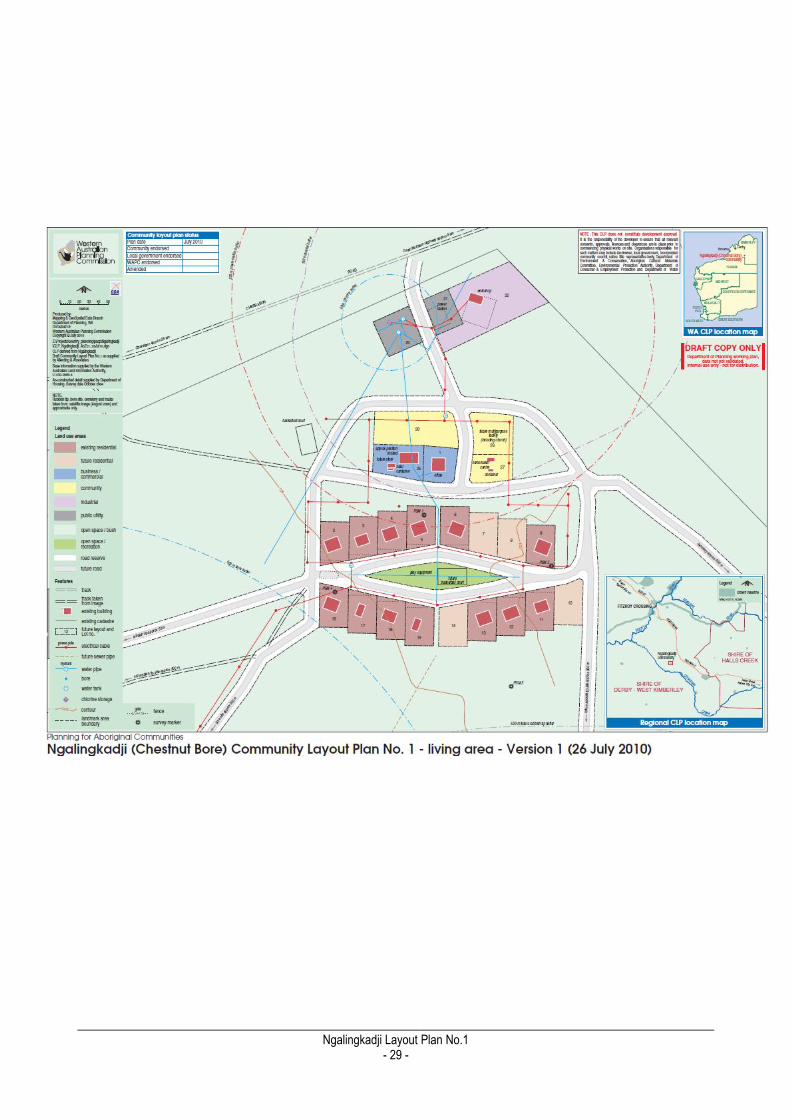
7. DESIGN PRINCIPLES AND LAND USES
7.1 Lot Numbering and Street Names
Numbering the lots so that they match the existing house numbers and naming the streets,
including proposed new streets is an important part of providing services to every house
and building. Because the existing land tenure and ownership arrangements at
Ngalingkadji do not always match the location of buildings and roads, the lots and
numbers on the CLP are defined as “future layout and lot number”.
To facilitate easy identification of places for administrative purposes and in case of
emergency, the CLP has assigned lot numbers to every designated land area in
Ngalingkadji. One set of numbers has been used to avoid duplication. It should be noted
that the future lot numbers and street names are not formal in a land tenure or gazettal
sense - they have been adopted to provide guidance only.
7.2 Residential
The plan shows the existing houses as "existing residential" and required houses as
"future residential".
The CLP plans for:
13 existing community houses; and
3 available vacant lots with adjacent services and 1 lot which requires short
extensions to power and water services.
7.3 Business / Commercial
The plan shows the store and other non-industrial commercial uses as
"business/commercial".
The CLP plans for:
The community office (Lot 1); and
A future small store (Lot 25).
7.4 Industrial
The plan shows all existing and proposed industrial uses as "industrial".
The CLP plans for:
The workshop (Lot 22);
The power station (Lot 21); and
The water storage tanks (Lot 20).
_________________________________________________________________________________________________________ Ngalingkadji Layout Plan No.1
- 27 -
7.5 Open Space / Recreation
The plan shows existing community open space (including the playground and relocated
basketball court) as "open space / recreation".
The CLP plans for:
Open space and basketball court (Lot 19).
7.6 Community Purposes
The plan shows existing community type uses as "community purposes".
The CLP plans for:
The homemaker centre (Lot 27);
The future multipurpose centre (Lot 26) and
The cemetery (Lot 29).
7.7 Public Utility
A “public utility” is anything that provides an essential physical service to the community,
things such as water bores, sewerage ponds, power station, and so on.
The CLP plans for:
The water tanks adjacent to the entrance to the community(Lot 20);
The current water bores 1/87 and 2/87(Lot 30);
The power station (Lot 21);
The workshop (Lot 22);
The rubbish tip (Lot 31) and
The future rubbish tip (Lot 32).
7.8 Open Space / Bush
The areas of the community that are not intended to be used for any specific purpose are
shown on the plan as "open space / bush". If development proposals should arise on this
land, development could be considered subject to an amendment to the CLP.

_________________________________________________________________________________________________________ Ngalingkadji Layout Plan No.1
- 28 -
7. PLANS
1. Ngalingkadji Community Layout Plan No. 1 - Living Area
2. Ngalingkadji Community Layout Plan No. 1 - Context and Surrounds
3. Ngalingkadji Community Layout Plan No. 1 - Land Ownership
4. Ngalingkadji Community Layout Plan No. 1 - Aerial
_________________________________________________________________________________________________________ Ngalingkadji Layout Plan No.1
- 29 -
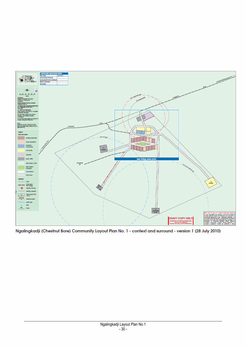
_________________________________________________________________________________________________________ Ngalingkadji Layout Plan No.1
- 30 -
_________________________________________________________________________________________________________ Ngalingkadji Layout Plan No.1
- 31 -

_________________________________________________________________________________________________________ Ngalingkadji Layout Plan No.1
- 32 -
_________________________________________________________________________________________________________ Ngalingkadji Layout Plan No.1
- 33 -
8. ENDORSEMENTS


_________________________________________________________________________________________________________ Ngalingkadji Layout Plan No.1
- e -
REFERENCES & INFORMATION Australian Bureau of Meteorology (BOM) 2009 Climate Statistics for Australian Locations
(Cadjebut). Available http://www.bom.gov.au/climate/averages/tables/cw_013007.shtml
Department of Indigenous Affairs (DIA) 2004 Environmental Health Needs Survey of
Indigenous Communities in Western Australia. Government of Western Australia.
Available at: www.dia.wa.gov.au
Department of Indigenous Affairs (DIA), Aboriginal Heritage Inquiry System. Available at
http://www.dia.wa.gov.au/AHIS/
Department for Planning and Infrastructure 2009 Fitzroy Futures Town Plan. Government of
Western Australia.
Kimberley Regional Service Providers(KRSP), Ngalingkadji Asset Condition Report 2006/07.
Lindsay, R. P. & D. P Commander 2005 Hydrological Assessment of the Fitzroy Alluvium.
Hydrological Report Series No. 238. Department of Environment, Western Australia.
Morphy, F. 2010 Population, People and Place: The Fitzroy Valley Population Project
Centre for Aboriginal Economic Policy Research. CAEPR Working Paper No. 70/2010.
ANU: Canberra.
_________________________________________________________________________________________________________ Ngalingkadji Layout Plan No.1
- f -
APPENDICES Appendix 1 Record of Certificate of Crown Land Titles Appendix 2 Registered Aboriginal Heritage Sites proximate to Ngalingkadji

_________________________________________________________________________________________________________ Ngalingkadji Layout Plan No.1
- g -
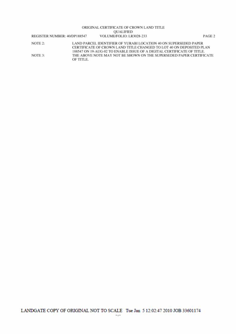
Appendix 1
Record of Certificate of Crown Land Titles

_________________________________________________________________________________________________________ Ngalingkadji Layout Plan No.1
- h -
_________________________________________________________________________________________________________ Ngalingkadji Layout Plan No.1
- i -
_________________________________________________________________________________________________________ Ngalingkadji Layout Plan No.1
- j -
Appendix 2
Registered Aboriginal Heritage Sites proximate to Ngalingkadji
_________________________________________________________________________________________________________ Ngalingkadji Layout Plan No.1
- k -
_________________________________________________________________________________________________________ Ngalingkadji Layout Plan No.1
- l -

_________________________________________________________________________________________________________ Ngalingkadji Layout Plan No.1
- m -

AMENDMENTS


![[Mike_S._Fowler]Animation Background Layout From Student to Professional.pdf](https://img.pdfslide.net/doc/110x75/56d6bd881a28ab30168e5d48/mikesfowleranimation-background-layout-from-student-to-professionalpdf.jpg)