Embed Size (px)
Citation preview

Northern Gulf Coastal Hazards Collaboratory (NG-CHC) (ngchc.org)
NGCHC addresses a problem of major national importance – engineering design, coastal system response, and risk management of coastal hazards.

NG-CHC Parameters
• NSF EPSCoR (Experimental Program to Stimulate Competitive Research) (“ ..directed at those jurisdictions that have historically received lesser amounts of NSF R&D funding.”)
• RII (Research Infrastructure Improvement) Track 2 (“..support innovation-enabling cyberinfrastructure of
regional, thematic, or technological importance.”)
• 3 years, $6 M total
• Project Duration: Oct 2010 to Sept 2013


UNO
LSU ULL
Jackson, MS
Univ. of Mississippi
Southern Mississippi
Jackson State
Mississippi State
Internet2 NLR
1GE
1GE
1GE
1GE
10GE 10GE
40GE
10GE 1GE & 10GE
21.78 Tflops LSU HPC systems 50.7 Tflops LONI Queen Bee cluster
EPS-RII-Track-2 NG-CHC Network Connectivity
1GE & 10GE
5.62 Tflops LONI HPC systems
5.62 Tflops LONI HPC systems
UAH
UA
UASRON
10GE 10GE
10GE
USA
10GE
AAMU
155 MBPS
10GE
Figure 2. Hardware and high performance systems among Alabama, Louisiana and Mississippi that will support the Northern Gulf Coastal Hazard Collaboratory.

The Transformation of the River: The Future

NG-CHC Vision
“..advance research, enrich training, and inspire collaboration through highly available innovation-enabling CI (cyberinfrastructure), with a particular focus on geosciences and engineering from the watershed to the coast.”

Northern Gulf Coastal Hazards Collaboratory (NG-CHC) (ngchc.org)
Was established to accomplish the following goals: (1) enhance the research competitiveness of the region, (2) advance economic opportunities for our citizens by reducing risks to coastal
vulnerabilities, and (3) catalyze collaborative research via enhanced cyberinfrastructure (CI) The three states in the consortium—Alabama (AL), Louisiana (LA), and Mississippi (MS)—are
leveraging their unique partnerships, proximity, and significant prior investments in CI to advance science and engineering of coastal hazards across the region.

1. RII Track-2 CI investments will focus on enhancement of the data
storage along with computing and data management systems that are essential for addressing the challenges of a distributed Coastal Hazard Collaboratory.
1. The objective is to enhance the robustness of connectivity among
NG- CHC institutions and resources. Crucial to the success of this project is the training and development of students, post-docs and others to establish a strong workforce who can lead the development of new cybertools and research.

NG-CHC Approach (concluded)
Use the simulation experiments as the
platforms for pursuing five CI strategies: 1. Validate geospatial information to improve
model grid development
2. Community modeling framework
3. Interoperable data sources
4. NG-CHC development
5. Education & outreach

Northern Gulf Coastal Hazards Collaboratory NG-CHC
(LA-MS-AL Consortium)
Shared High-Speed Networks and Data Storage
Catchment to Coast Geoinformatics
Dynamic Digitial Elevation Model / Smart Grids
NG-CHC Simulation Experiments
(four experiments)
Advanced Cyber Capacity, Networking Observations,
Modeling and Simulation Tools Decision-making Tools Watershed/River
Flood Models
ADCIRC Surge Guidance System
Verification and Validation using
Observations Systems Of NG-CHC;
Visualization of Coastal Risks, and
Restoration; Planning & Protection
Linked To Economic Development
Ecosystem Restoration and Flood Risks Reduction
Figure 3: Strategic Plan for the Northern Gulf Coastal Hazard Collaboratory
Mississippi River Flood Models

CORS/GulfNet/ Height Elevation
Digital Gulf Coast Project
Dynamic Digital Elevation Model (DDEM)
Watershed/River Flood Models ADCIRC Surge Guidance System Ecosystem Restoration and
Flood Risks Reduction
Bathymetry Surveys
Cyberinfrastructure
CyberTools / Portals / PetaShare / Visualization Model Ensembles/ Middleware / Data management
Verification / Model Assimilation
LIDAR/Topographic Surveys

Dynamic Digital Elevation Modeling • One of the greatest challenges for addressing water-land interactions is to
seamlessly link water and land databases, and models.
– Traditionally, land (topographic) data has been referenced to a geodetic vertical datum, such as NAVD88, which is approximately mean sea level (~geoid)
– Hydrographic data (bathymetric), on the other hand, is related to a local chart datum (CD), which is usually some mean lower low water (MLLW) determined in the area

Data Resolution – what is optimal?

Project Definitions
• Inventory of earth surface data and its characteristics
• Create ADCIRC grid for northern GoM
• Create “coastal” earth surface model
• Create “upland” and “marine” surface model
• Define cybertool needs – survey modelers
• Create cybertools needed by simulation experiments


CORS/GulfNet/ Height Elevation
Digital Gulf Coast Project
Dynamic Digital Elevation Model (DDEM)
Watershed/River Flood Models ADCIRC Surge Guidance System Ecosystem Restoration and
Flood Risks Reduction
Bathymetry Surveys
Cyberinfrastructure
CyberTools / Portals / PetaShare / Visualization Model Ensembles/ Middleware / Data management
Verification / Model Assimilation
LIDAR/Topographic Surveys

Coastal Emergency Risks Assessment (CERA) – Louisiana CERA – NC; CERA – Northern Gulf (1)
Query results for each grid node: - storm surge elevation - elevation/bathymetry - storm surge depth - wind speed - ADCIRC grid node classification (land/water)
Track query: - max. speed - min. pressure - max. radius, - gusts - eye diameter - storm direction - storm speed

A Framework for Geospatial Applications and Decision
Support for the Northern Gulf Institute
Sulis (2) A Tool for Healthy Watersheds, Healthy Oceans, Healthy
Ecosystems

Ecosystem Restoration and Flood Risks Reduction (3)
Background winds
Hurricane parameters
Bathymetry/Topography
Other inputs
Wind
Model
ADCIRC
SWAN
DELFT3D/FVCOM/CaFunwave
Regional domain
Gulf-scale
Output files
Model verification
Visualization
Data mining
Nesting
Water level Current
Radiation stress
Water level Current
Wave parameters
Initial & boundary conditions

Mississippi River Simulations (4) • Hydraulic surge propagation in the River due to
storm surges with proposed coastal restoration projects, e.g. large scale diversions.
– Subject to boundary conditions provided by Surge Modeling Outputs
– Provide River boundary conditions for Coastal Modeling Group.

Proposed Experiments
• River response (flow, sediment and energy) to land building diversions:
– Subject to boundary conditions provided by Coastal Modeling Group.
– Flood hazard changes due to land building diversions.


Coastal Emergency Risks Assessment (CERA) – Louisiana CERA – NC; CERA – Northern Gulf
Query results for each grid node: - storm surge elevation - elevation/bathymetry - storm surge depth - wind speed - ADCIRC grid node classification (land/water)
Track query: - max. speed - min. pressure - max. radius, - gusts - eye diameter - storm direction - storm speed
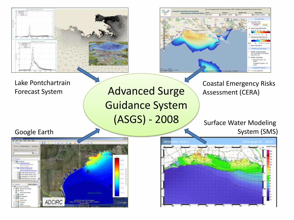
Advanced Surge Guidance System
(ASGS) - 2008 Surface Water Modeling System (SMS) Google Earth
Lake Pontchartrain Forecast System
Coastal Emergency Risks Assessment (CERA)

O
Storm Features (ADCIRC grid, barriers…)
5 track variations: main track, 20% decrease, 20% increase, 20% left side track, 20% right side track)
Hurricane ALERT (GOHSEP)
ADCIRC Model Run
Model output data (for each of the 5 tracks): - max storm surge, - max wind speed, - depth, - track - predicted hydrographs
GeoTIFF Converter
Retrieve and convert hurricane track information (NHC)
GOOGLE Maps
Stores the storm metadata and internal information to customize the CERA website
Database, Shapefiles
Tiled TIF images (surge, wind, depth) O
Track paths and track info, time labels
Advisory Parser
O
SHP Converter
CERA Google Map
Convert predicted hydrographs, retrieve real-time hydrographs
O Query Info

26
The Sulis Framework
Sulis Informatics Services (SIS) Sulis Community
Ecosystem Models (SCEM)
with
Human Systems
Biotic Systems
Physical Systems

Model Linkages

Framework

• SIS – Model coupling tools – ERDC framework – External database connections – NEON, others? – Fast pipes for model data across NGCHC – Inference Engine
• Data Needed by MSU – Mobile Bay Surge Results (ASGS Group) – Mobile Basin Geo-biophysical Results (UA) – Resource Managers’ evaluations (MSU)
• SCEM Models Needed – Landscape Evolution – Economic Consequences – Social Responses
Cyber Tools Needed/Under Development

NG-CHC Development of Cyber Tools for Ecosystem Restoration
and Flood Risks Reduction (ERFRR) in the Northern Gulf Coast
Annual Retreat January 26-27, 2012

Toolbox I: Model System
Background winds
Hurricane parameters
Bathymetry/Topography
Other inputs
Wind
Model
ADCIRC
SWAN
DELFT3D/FVCOM/CaFunwave
Regional domain
Gulf-scale
Output files
Model verification
Visualization
Data mining
Nesting
Water level Current
Radiation stress
Water level Current
Wave parameters
Initial & boundary conditions

Toolbox II: A Parallel Interpolation Tool for Model Communication/Integration
Scattered source data
Intermediated model communication data
Archived output data
Data Massaging
Tools
Curvilinear grids Unstructured mesh
User-defined region, profile or specific stations

Toolbox III: Coastal Data Factory for the Northern Gulf

Toolbox IV: SIMULOCEAN A Simulation Management Portal

Summary
• Prototypes of four CI tools have been developed for the assessment of flood risk reduction by ecosystem restoration. These are
1) A model system (w/ 5 models) on HPC 2) A parallel interpolation tool 3) SIMULOCEAN 4) Coastal data factory • A demo will be shown for each tool.
• Simulation data of six hurricanes are available.
• Visit LSU project website http://ngchc.org via the NHCHC
portal. (User name: ngchc; Password: ngchctiger)


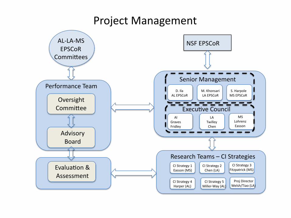
ProjectManagement
SeniorManagement
NSFEPSCoR
AlGravesFridley
LATwilleyChen
MSLohrenzEasson
M.KhonsariLAEPSCoR
D.IlaALEPSCoR
S.HarpoleMSEPSCoR
ResearchTeams–CIStrategies
AL-LA-MSEPSCoR
Commi ees
PerformanceTeam
OversightCommi ee
Evalua on&Assessment
AdvisoryBoard
Execu veCouncil
CIStrategy1Easson(MS)
CIStrategy2Chen(LA)
CIStrategy3Fitzpatrick(MS)
CIStrategy4Harper(AL)
CIStrategy5Miller-Way(AL)
ProjDirectorWelsh/Tiao(LA)


External Advisory Board: 1. Dr. Rick Luettich: Rick Luettich serves as the Director of UNC’s Institute of Marine Science,
which is comprised of approximately 75 residential faculty, staff and students located on the coast in Morehead City, North Carolina. He also serves as Director of the UNC Center for Natural Hazards and Disasters in Chapel Hill and is the lead-PI on the Department of Homeland Security Center of Excellence in Natural Disasters, Coastal Infrastructure and Emergency Management (DIEM).
2. Dr. Johannes Westerwink: Director of Notre Dame’s Computational Hydraulics Laboratory, Westerink is the co-developer of the Advanced Circulation Model (ADCIRC), which is the authoritative computer model for storm surge used by the U.S. Army Corps of Engineers, the Federal Emergency Management Agency (FEMA) and the state of Louisiana to determine water levels due to hurricane surge and to design levee heights and alignments.
3. Dr. Efi Foufoula Georgiou: Efi Foufoula-Georgiou is a University of Minnesota McKnight Distinguished Professor in the Department of Civil Engineering and Director of the NSF Science and Technology Center “National Center for Earth-surface Dynamics” (NCED). She is currently the chair of the Board of Directors for CUAHSI (Consortium of Universities for the Advancement of Hydrologic Sciences), a member of the Board of Trustees of UCAR (University Corporation for Atmospheric Research), and a member of the Advisory Council of the GEO directorate of NSF.
4. Dr. William Michener: Bill Michener (University of New Mexico) is Professor and Director of e-Science Initiatives for University Libraries at the University of New Mexico. Presently, he directs the New Mexico EPSCoR Program and is Principal Investigator for DataONE—a large NSF-supported multi-institutional, multi-national program focused on data preservation
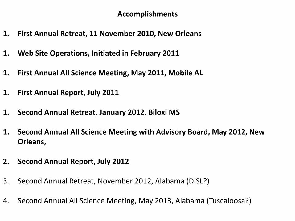
Accomplishments
1. First Annual Retreat, 11 November 2010, New Orleans 1. Web Site Operations, Initiated in February 2011 1. First Annual All Science Meeting, May 2011, Mobile AL 1. First Annual Report, July 2011 1. Second Annual Retreat, January 2012, Biloxi MS 1. Second Annual All Science Meeting with Advisory Board, May 2012, New
Orleans,
2. Second Annual Report, July 2012
3. Second Annual Retreat, November 2012, Alabama (DISL?)
4. Second Annual All Science Meeting, May 2013, Alabama (Tuscaloosa?)


![Systematic Problem Solving in Production: The NAX Approach...8-step problem solving process [3], [4], and [10]. They all describe the importance of defining the problem, conducting](https://img.pdfslide.net/doc/110x75/5ee31c50ad6a402d666d309c/systematic-problem-solving-in-production-the-nax-approach-8-step-problem-solving.jpg)