Embed Size (px)
Citation preview

NGGPS Ocean Planning
at NCEP/EMC
― Avichal Mehra, Robert Grumbine, Arun Chawla
and Hendrik Tolman
July 2015

OUTLINE
― Current Status and upgrades
• Oceans
• Waves
― Planned projects
• Oceans
• Waves
• Arctic
― Performance Metrics
• Oceans
• Waves
• Sea Ice
• Coupled Systems

CURRENT STATUS

― Modular Ocean Model (MOM) with Global Ocean Data
Assimilation System (GODAS)
• Seasonal scales
• GFDL support
• Integral part of CFSv2
• Continued support for CFSv3 development
― Hybrid Coordinate Ocean Model (HYCOM) with Navy Coupled
Ocean Data Assimilation (NCODA)
• Weather time scales
• NRL and academia support
• Integral part of RTOFS systems
• Expected R2O support for gaps
Two Ocean Modeling Systems

RTOFS OVERVIEW
Five major efforts: – Eddy resolving ocean modeling
– Eddy resolving ocean initialization
– Coupled modeling for hurricanes.
– Coupled modeling for weather – Global V1.1, CFS/NEMS
– Tracers
– All RTOFS models presently based on HYCOM
• RTOFS represent line of products
• HYCOM is underlying ocean model
Strong collaboration with US Navy, leveraging core HYCOM and data assimilation developments at NRL.
Operational 2005 RTOFS-Atlantic
Operational 2011 RTOFS-Global
Live testing (2014) RTOFS-HWRF
Under development RTOFS-NEMS, NCODA
Fukushima (2012-2014), BGC coupling (started 2015)

• NCEP implemented RTOFS-Global v1.0 in operations on
10/25/11 using Global HYCOM developed by US Navy
• NAVO is delivering initialization data daily (NCODA-3DVar)
• MMAB/EMC has converted Navy model to be forced with
GFS/GDAS fluxes.
• More details (and links to pubs) available at:
http://polar.ncep.noaa.gov/global/
• Planned major upgrade for August/September 2015 on phase II
RTOFS Global Current Status
RTOFS Global FY15 Upgrade
Primary upgrades (developed by NRL):
• 41 hybrid layers (increased from 32 layers)
• Air-Sea boundary flux improvements for coupled
applications (including Hurricanes)
• Finer resolution for mixed layer (9 additional near
surface layers)
• Improved vertical coastal resolution for downstream
applications (NOS OFS, IOOS RA’s)
• Two-way coupled HYCOM with Los Alamos CICE (Community
ICE code) (which replaces Energy-Loan Sea-Ice model)
• 1 hour coupling frequency
• Using ESMF v4.0 (non-NUOPC)
• Additional forecasts (ice thickness, ice concentration, ice
drift and stress)
• Improved climatology/bathymetry

• Update codes to unify with
RTOFS Global.
• Improve representation of
basin geometry.
• Updates to data assimilation
algorithm with new data sets
for surface (SST, SSH, SSS).
• Updates to open boundary
conditions to prevent drift.
• Ready to receive boundary
data from RTOFS-Global
(one-way nest)
RTOFS Atlantic FY16 Upgrade

Coupled hurricane modeling with regional ocean components
N. Atlantic
9
Coupled HWRF-HYCOM System
Current:
Future - basin
HWRF parent
W. Pacific
E. Pacific

Wave Model Suites at NCEP
• A global wave model
– Driven by GFS winds
– Consists of 9 grids (two – way nested)
• A hurricane wave model
– Driven by GFS + HWRF winds
– Consists of 10 grids (global domain)
• An ensemble wave model
– Driven by GEFS winds
– Single global grid
• Great Lakes model
• Near Shore Wave Prediction System (NWPS)
– On demand local wave modeling systems
WAVEWATCH III
SWAN (WAVEWATCH III to be added later)

PLANNED PROJECTS

• HYCOM coupled to GSM/GFS using ESMF NUOPC layer
within NEMS
• Mediators/connectors also being built for Sea Ice, Waves
and Land components
• ¼ degree Global, 50-60 layers, ensembles of 4 members
per day (120 per month)
• 1/12 degree regional or basin-scale, 50-60 layers, 10-20
member ensembles (leverage Arctic-coupling)
• Unified Data Assimilation (LETKF/Hybrid)
RTOFS NEMS
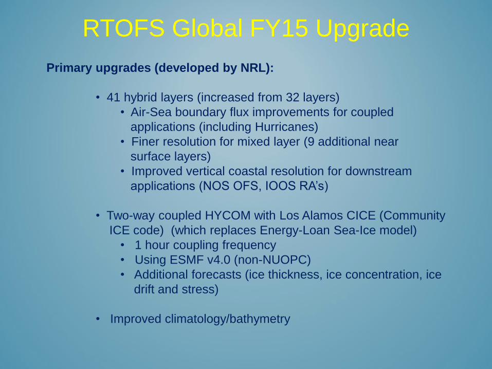
Wave model coupling
• NEMS capability being developed for WAVEWATCH III
• In the next one year develop a wave – atmosphere – ocean
coupled modeling system for the Climate Forecast System
– Coupling to be developed for a single grid
– Study the impact of coupled systems in skill scores for both
atmospheric and ocean systems
• Develop a wave – ocean coupled system for HYCOM to
incorporate Langmuir mixing due to Stokes drift.
• In year 2 expand NEMS coupling of wave model and atmospheric
model using multiple grids (for the wave model)
• A prototype wave – ocean – hurricane coupled system being
developed
– Will transition to NEMS once HWRF is NEMS compatible

• After year 2, the regular coastal grids in global model will be
replaced by unstructured grids
– Coastal unstructured domains to be coupled with surge
models (ADCIRC)
• Local models
– Coupled wave – atmosphere – circulation system for the
Great Lakes
• Coupling with FVCOM and atmospheric model
• Currently developing wave model on FVCOM
unstructured grid
– Coupled Arctic modeling system
• Curvilinear Arctic grid to model waves to the North Pole
(currently being added to Global wave model)
• Advanced wave – ice interaction processes (physics
packages under development at collaborative institutes
– Wave – surge – current coupling for the local NWPS systems
Wave model coupling (cont.)

Ocean Data Assimilation Plans
• Signed MOU with Navy to implement NCODA at NCEP for
operational use.
– Initially for RTOFS Global
– 3DVAR, seven overlapping regions
– Configure to use NCEP data tanks and data streams.
– Tentative implementation FY 2016/2017.
– Add new observations in the future (e.g. SSS, HF Radar)
– Extend to all RTOFS applications (3DVar and Hybrid)
– To be funded by NGGPS
NCODA

Ocean Data Assimilation Plans
• Transition Hybrid 3DVar/LETKF global ocean data assimilation
to operations
– NGGPS funded project at Univ. of Md
– Target CFSv3
– Build new ensemble-based ocean data assimilation
systems
– Unified DA applications
– MOM tests underway
– HYCOM tests under development
HYBRID/LETKF

Data assimilation in wave models
• Wave data assimilation developing along two tracks
– A GSI based data assimilation approach
– An LETKF based data assimilation approach
• Develop a hybrid approach to improve wave model skill
• Once models are coupled, develop a coupled data assimilation for
wave – atmosphere – ocean
– Tentative test case for this is the CFS as the different model
components use similar data assimilation approaches
HYBRID/LETKF

Data assimilation for Sea Ice
• CPO/CVP supported project with Jiping Liu (SUNY Albany)
• Focus is on CFSv3 (starting from CFSv2 algorithm)

Coupled Atmosphere-Ocean-Ice System
• Leverage developments of common building blocks within
NEMS
• NMMB-HYCOM-KISS
• Bias corrections to heat fluxes
• Focus on Sea-Ice predictability
• Use ensembles to minimize random flux errors
• New skill metrics
• Customize ice products for users
• To be funded by NGGPS
ARCTIC

PERFORMANCE METRICS

• Daily monitoring of fields using GODAE Class Metrics:
– Class 1 (analysis of surface fields SST, SSH)
– Class 2 (ARGO profiles, WOCE sections)
– Class 3 (Florida Current transports, GS North Wall location)
– Class 4 (Forecast skill metrics: SST, SSH, ARGO profiles)
Daily metrics made available at:
http://polar.ncep.noaa.gov/global/monitor/
OCEAN METRICS
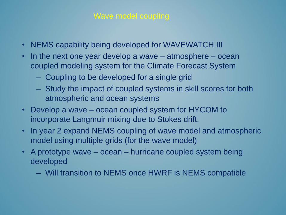
RTOFS Para vs RTOFS Ops vs MADT SSHA
The two simulations are comparable with the parallel performing marginally
better (approx. 1 cm RMSE).

Differences in the Arctic region (May 2015)
Sea Ice Cover RTOFS Para vs RTOFS Ops vs Analysis

Differences in the Arctic region (May 2015)
Sea Ice Cover RTOFS para vs RTOFS Ops vs Analysis

• Recent papers on Verification and Metrics
– Garraffo et al., 2014. Modeling of 137Cs as a tracer in a regional model for
the Western Pacific, after the Fukushima Daiichi Nuclear power plant
accident of March 2011. Weather and Forecasting. doi:
http://dx.doi.org/10.1175/WAF-D-13-00101.1
– Ryan et al., 2015. GODAE Ocean View Class 4 forecast verification
framework: Global ocean inter-comparison. J Oper Oceanogr. 7(3)
– Divakaran et al., 2015. GODAE OceanView Inter-comparison for the
Australian Region. J Oper Oceanogr. doi:10.1080/1755876X.2015.1022333.
– Hernandez et al., 2015.Recent progress in performance evaluations and near
real-time assessment of operational ocean products. J. Oper. Oceanogr.
(accepted)
OCEAN METRICS

Global wave model skill scores for 72 hour forecast
Monthly skill scores Seasonal skill scores
Time in MM/YY Skill scores based on comparisons at all available NDBC buoys
New Physics introduced

• Daily Sea Ice Concentrations
• Sea Ice Drift Speeds
• Others: design remains a challenge
SEA ICE METRICS

Immature
― 500 mb anomaly correlation versus surface ocean winds
― Significant wave heights versus sea surface temperature
― Precipitation threat scores versus sea surface heights
― Sea ice concentration versus tropical SST
Not that there are no measures, but it must be
developed/examined which measures, in which areas, are
most important for assessing coupled systems.
COUPLED METRICS

Back Up Slides

• Basin scale models:
– RTOFS-Arctic: New model, coupled to NMMB, Sea Ice, Waves.
– RTOFS-Atlantic: New finer grid.
– RTOFS-Pacific: New model for East Pacific.
– Deterministic (at 1/24° or 1/36° degree)
– Nested in Global.
– Coupled:
• Waves for upper ocean mixing (and surface fluxes if coupled to
atmosphere)
• Ice and atmosphere for Arctic.
– Ensembles (at 1/12 degree, 20-40 members), particularly for
Arctic.
RTOFS FUTURE
Ocean Modeling Plans for Short-to-Medium Time Scales

• Global: deterministic, higher vertical resolution (~ 100), horizontal
stays at 1/12°, coupled via ESMF in NEMS
— New data types for NCODA (SSS, Ocean Color, Sea-Ice
Thickness, HF-Radar etc. )
— Better MLD, OHC, coupling with waves for Langmuir and
Stokes mixing in ocean.
— Coupled Bio-Geo-Chemical module(s) for Eco-Forecasting
Applications
• HYCOM-HWRF
― Coupling within NEMS with up to 100 hybrid layers
― Coupling with WW III®.
― Operational in Atlantic, East Pacific, West Pacific and Indian
― Development of apropos data assimilation modules
RTOFS FUTURE
Ocean Modeling Plans for Short-to-Medium Time Scales

RTOFS Users and Partners Primary Users:
NWS: EMC, OPC,
NHC, coastal WFO’s
NOS:
CO-OPS,
CSDL,IOOS RA’s
OAR:
AOML/HRD
DHS:
US Coast Guard
Primary research partners: NRL, ESRL, AOML, NESDIS/STAR, JPSS-RR,
JCSDA, UMD, RSMAS, JAEA (Japan), UK Met Office, BOM (Australia)
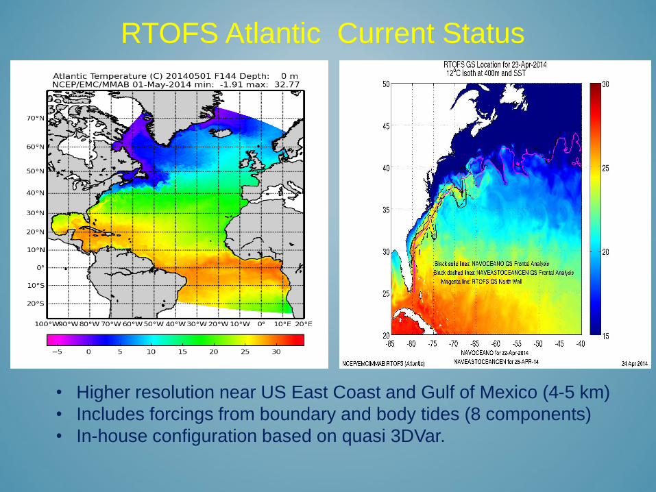
• Higher resolution near US East Coast and Gulf of Mexico (4-5 km)
• Includes forcings from boundary and body tides (8 components)
• In-house configuration based on quasi 3DVar.
RTOFS Atlantic Current Status