Embed Size (px)
Citation preview

NI 43-101 TECHNICAL REPORT
on the
LYNX LAKE COPPER-COBALT PROPERTY
Happy Valley – Goose Bay, Labrador, Canada
by
Edward Lyons, P.Geo.
TEKHNE RESEARCH INC.
Victoria, BC
for
KING’S BAY GOLD CORP.
Vancouver, BC
Effective Date 21 November 2016
Issue Date 30 November 2016

NI 43-101 TECHNICAL REPORT – LYNX LAKE CU-CO PROPERTY, LABRADOR
Page 2 of 29
Cautionary Statements Regarding Forward Looking Information
This Technical Report contains "forward-looking information" within the meaning of Canadian securities
legislation. All information contained herein that is not clearly historical in nature may constitute forward-
looking information. Forward-looking information includes, without limitation, statements regarding the
results of the Technical Report, including statements about the estimation of mineral reserve and resources
statements, future exploration on the project, the market and future commodity prices, permitting, and the
ability to finance the project.
Generally, such forward-looking information can be identified by the use of forward-looking terminology such
as "plans", "expects" or "does not expect", "is expected", "budget", "scheduled", "estimates", "forecasts",
"intends", "anticipates" or "does not anticipate", or "believes", or variations of such words and phrases or
state that certain actions, events or results "may", "could", "would", "might" or "will be taken", "occur" or "be
achieved".
Forward-looking information is based on assumptions believed to be reasonable at the time such statements
are made, including but not limited to, continued exploration activities, gold and other metals prices, the
estimation of initial and sustaining capital requirements, the estimation of labor and operating costs, the
estimation of mineral reserves and resources, the assumption with respect to currency fluctuations, the timing
and amount of future exploration and development expenditures, receipt of required regulatory approvals,
the availability of necessary financing for the project, the completion of the permitting process, and such other
assumptions and factors as set out herein.
Forward-looking information is subject to known and unknown risks, uncertainties and other factors that may
cause the actual results, level of activity, performance or achievements of Logan Resources to be materially
different from those expressed or implied by such forward-looking information, including but not limited to:
volatile stock price; risks related to changes in commodity prices; sources and cost of power facilities; the
estimation of initial and sustaining capital requirements; the estimation of labor and operating costs; the
general global markets and economic conditions; the risk associated with exploration, development and
operations of mineral deposits; the estimation of mineral reserves and resources; the risks associated with
uninsurable risks arising during the course of exploration, development and production; risks associated with
currency fluctuations; environmental risks; competition faced in securing experienced personnel; access to
adequate infrastructure to support mining, processing, development and exploration activities; the risks
associated with changes in the mining regulatory regime; completion of the environmental assessment
process; risks related to regulatory and permitting delays; risks related to potential conflicts of interest; the
reliance on key personnel; financing, capitalization and liquidity risks including the risk that the financing
necessary to fund development and construction of the Project may not be available on satisfactory terms, or
at all; the risk of potential dilution through the issue of common shares; the risk of litigation.
Although Tekhne Research and the Issuer have attempted to identify important factors in this Report that
could cause actual results to differ materially from those contained in the forward-looking information, there
may be other factors that cause results not to be as anticipated, estimated or intended. There can be no
assurance that such forward-looking information will prove to be accurate, as actual results and future events
could differ materially from those anticipated in such forward-looking information. Accordingly, readers should
not place undue reliance on forward-looking information. Forward-looking information is made as of the date
of this technical report, and the Issuer does not undertake to update such forward-looking information except
in accordance with applicable securities laws.
NI 43-101 TECHNICAL REPORT – LYNX LAKE CU-CO PROPERTY, LABRADOR
Page 3 of 29
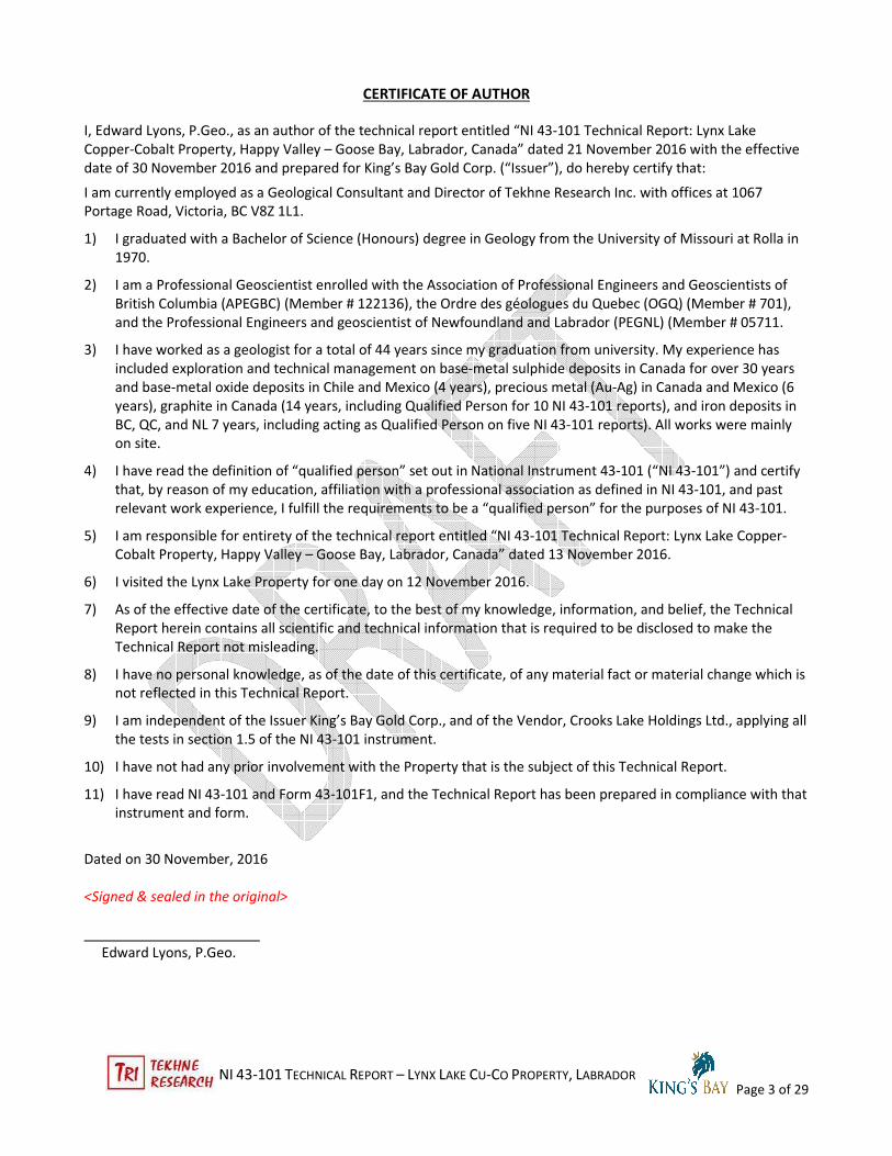
CERTIFICATE OF AUTHOR
I, Edward Lyons, P.Geo., as an author of the technical report entitled “NI 43-101 Technical Report: Lynx Lake
Copper-Cobalt Property, Happy Valley – Goose Bay, Labrador, Canada” dated 21 November 2016 with the effective
date of 30 November 2016 and prepared for King’s Bay Gold Corp. (“Issuer”), do hereby certify that:
I am currently employed as a Geological Consultant and Director of Tekhne Research Inc. with offices at 1067
Portage Road, Victoria, BC V8Z 1L1.
1) I graduated with a Bachelor of Science (Honours) degree in Geology from the University of Missouri at Rolla in
1970.
2) I am a Professional Geoscientist enrolled with the Association of Professional Engineers and Geoscientists of
British Columbia (APEGBC) (Member # 122136), the Ordre des géologues du Quebec (OGQ) (Member # 701),
and the Professional Engineers and geoscientist of Newfoundland and Labrador (PEGNL) (Member # 05711.
3) I have worked as a geologist for a total of 44 years since my graduation from university. My experience has
included exploration and technical management on base-metal sulphide deposits in Canada for over 30 years
and base-metal oxide deposits in Chile and Mexico (4 years), precious metal (Au-Ag) in Canada and Mexico (6
years), graphite in Canada (14 years, including Qualified Person for 10 NI 43-101 reports), and iron deposits in
BC, QC, and NL 7 years, including acting as Qualified Person on five NI 43-101 reports). All works were mainly
on site.
4) I have read the definition of “qualified person” set out in National Instrument 43-101 (“NI 43-101”) and certify
that, by reason of my education, affiliation with a professional association as defined in NI 43-101, and past
relevant work experience, I fulfill the requirements to be a “qualified person” for the purposes of NI 43-101.
5) I am responsible for entirety of the technical report entitled “NI 43-101 Technical Report: Lynx Lake Copper-
Cobalt Property, Happy Valley – Goose Bay, Labrador, Canada” dated 13 November 2016.
6) I visited the Lynx Lake Property for one day on 12 November 2016.
7) As of the effective date of the certificate, to the best of my knowledge, information, and belief, the Technical
Report herein contains all scientific and technical information that is required to be disclosed to make the
Technical Report not misleading.
8) I have no personal knowledge, as of the date of this certificate, of any material fact or material change which is
not reflected in this Technical Report.
9) I am independent of the Issuer King’s Bay Gold Corp., and of the Vendor, Crooks Lake Holdings Ltd., applying all
the tests in section 1.5 of the NI 43-101 instrument.
10) I have not had any prior involvement with the Property that is the subject of this Technical Report.
11) I have read NI 43-101 and Form 43-101F1, and the Technical Report has been prepared in compliance with that
instrument and form.
Dated on 30 November, 2016
<Signed & sealed in the original>
Edward Lyons, P.Geo.

NI 43-101 TECHNICAL REPORT – LYNX LAKE CU-CO PROPERTY, LABRADOR
Page 4 of 29
TABLE OF CONTENTS
Title Page
Date and Certificate of Author
Table of Contents
Illustrations
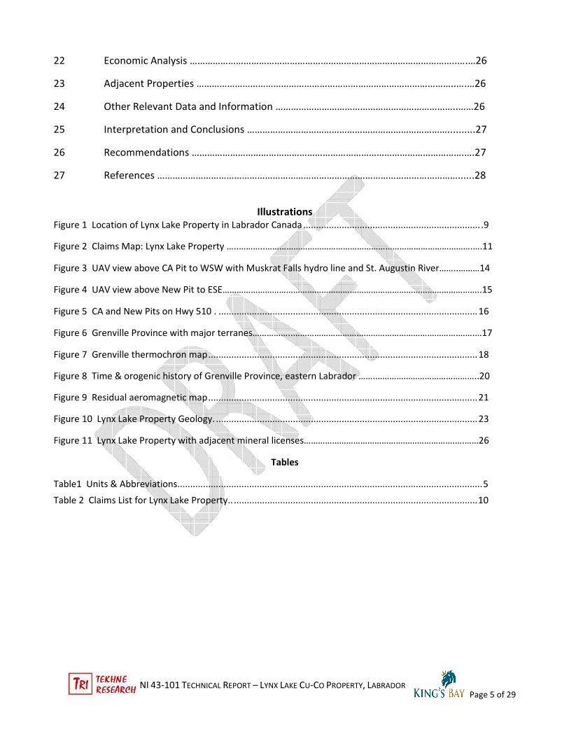
1 Summary ……………………………………………………………………………………………………..…………..6
2 Introduction …………………………………………………………………………………………………………..…7
3 Reliance on Other Experts ………………………………………………………………………………….…....9
4 Property Description and Location …………………………………………………………………….…….9
5 Accessibility, Climate, Local Resources, Infrastructure and Physiography ……………….13
6 History ………………………………………………………………………………………………………….…….….15
7 Geological Setting and Mineralization ……………………………………………………………….......16
8 Deposit Types ………………………………………………………………………………………………….……..24
9 Exploration ……………………………………………………………………………………………….…………...25
10 Drilling ……………………………………………………………………………………………..…………..…….....25
11 Sample Preparation, Analyses and Security ……………………………………………………...…….25
12 Data Verification ……………………………………………………………………………………….………..….25
13 Mineral Processing and Metallurgical Testing ……………………………………………………..….25
14 Mineral Resource Estimates …………………………………………………………………………………...25
15 Mineral Reserve Estimates …………………………………………………………………………..…..….…25
16 Mining Methods ……………………………………………………………………………………………..…...…25
17 Recovery Methods ………………………………………………………………………………………………....25
18 Project Infrastructure ………………………………………………………………………………………........25
19 Market Studies and Contracts …………………………………………………………………………...……25
20 Environmental Studies, Permitting and Social or Community Impact ……………………...25
21 Capital and Operating Costs …………………………………………………………………………….…….25
NI 43-101 TECHNICAL REPORT – LYNX LAKE CU-CO PROPERTY, LABRADOR
Page 5 of 29
22 Economic Analysis …………………………………………………………………………………………..….…26
23 Adjacent Properties ………………………………………………………………………………………..….…26
24 Other Relevant Data and Information ……………………………………………………………..……26
25 Interpretation and Conclusions ……………………………………………………………………..........27
26 Recommendations …………………………………………………………………………………………….….27
27 References ………………………………………………………………………………………………………......28
Illustrations
Figure 1 Location of Lynx Lake Property in Labrador Canada ..................................................................... .9
Figure 2 Claims Map: Lynx Lake Property …..………..…………………………………………………………………………….….11
Figure 3 UAV view above CA Pit to WSW with Muskrat Falls hydro line and St. Augustin River……..………14
Figure 4 UAV view above New Pit to ESE………………………………………………………………………………………………..15
Figure 5 CA and New Pits on Hwy 510 . ..................................................................................................... 16
Figure 6 Grenville Province with major terranes……………..…………………………………………………………….…….…17
Figure 7 Grenville thermochron map ......................................................................................................... 18
Figure 8 Time & orogenic history of Grenville Province, eastern Labrador …….……………………………………..20
Figure 9 Residual aeromagnetic map ......................................................................................................... 21
Figure 10 Lynx Lake Property Geology. ...................................................................................................... 23
Figure 11 Lynx Lake Property with adjacent mineral licenses……………………………………………………….….……26
Tables
Table1 Units & Abbreviations....................................................................................................................... 5
Table 2 Claims List for Lynx Lake Property.. ............................................................................................... 10

NI 43-101 TECHNICAL REPORT – LYNX LAKE CU-CO PROPERTY, LABRADOR
Page 6 of 29
1 SUMMARY
The Lynx Lake Property located approximately 134 km south and east by all-weather highway from Happy
Valley-Goose Bay, the regional centre for Labrador, Canada. Highway 510, the only main year-round road in
southeastern Labrador, passes through the north-central part of the property. The Property consists of 13
Mineral Licenses comprised of 959 on-line staked mineral claims of 25 hectares each for a total area of 23,975
ha (23.975 km2). The mineral rights apply to minerals hosted in the bedrock directly beneath the claim
boundaries.
On 27 October 2016, King’s Bay Gold Corporation (TSXV-KBG) (the "Issuer”) announced that it has entered into
an agreement dated 4 October, 2016 with Crooks Lake Holdings Ltd ("CLHL"), Cameron Martin, and Jeffrey
Martin, jointly the Vendors (“Vendor”), to acquire 100% interest in the Lynx Lake Property (formerly named
Crooks Lake Property) located in southeastern Labrador, Canada .
Under the terms of the Agreement, and subject to the approval of the TSX Venture Exchange, the Issuer will
acquire 100% interest and rights in the property by paying CLHL an aggregate of C$100,000 in cash, $10,000
being payable upon signing with C$30,000 payable on each of the three subsequent anniversaries of the
Agreement.
The Issuer will issue 900,000 common shares payable to CLHL as 200,000 shares upon exchange approval with
a tranche of 300,000 shares on the first year anniversary and 400,000 shares on the second anniversary of the
Agreement.
The Vendor retains a 1.5% Net Smelter Return (NSR) upon commencement of commercial production. The
Issuer can purchase 50% of the NSR from the Vendor at any time during the Agreement for C$1,000,000.
Additional mineral claims associated with the property by either the Issuer or Vendor during the term of the
Agreement will be subject to the same NSR terms.
The property is accessible from Happy Valley-Goose Bay, Labrador, the regional centre of Labrador and nearest
airport, by travelling west on Highway 500 nine km to the junction with Highway 510, the Trans-Labrador
Highway and turning left (south) for 125 km to the road into the New Pit south (right side) of the highway. The
CA Pit is about 1.6 km further ahead on the right (south) side adjacent to the highway. Highways 500 and 510
are all-weather roads paved to about 85 km on Highway 510 from Highway 500 and recently widened gravel
further to the east-southeast.
The area is rolling, forest covered hills with moderate to steep slopes and flatter valleys and tops. It appears to
be a glacial peneplain dissected by glacio-fluvial erosion. Moraine and esker glacial deposits locally shape the
topography as well. Elevations range from 390 m in lakes and valleys to ~500 m on the flat hill tops. The
nearest town is the town of Happy Valley-Goose Bay. Some heavy equipment and operator services are
available there, as well as transportation, food, and accommodation. More complete services, including drilling
and mining contractors, are available 500 km to the west in Labrador City, Labrador, the regional iron mining
centre.
Historically, the Vendor has conducted prospection-level exploration work from late 2009 to early 2016. The
annual assessment reports to the Newfoundland and Labrador government and recent documents provided by
the Vendor permit an evaluation of the Property. Many years of regional geological research, field work, and
studies by Dr. Charlie Gower of the Newfoundland and Labrador Department of Mines and Energy Geological
Survey, his associates, and students have contributed extensively to the understanding of the Grenville
Province development in south-central and eastern Labrador.

NI 43-101 TECHNICAL REPORT – LYNX LAKE CU-CO PROPERTY, LABRADOR
Page 7 of 29
The regional and property geology are formed on the accretion of various island arc terranes between 1800
through 1600 Ma that formed the Trans-Labradorian supercrustal assemblage, a Himalayan sized mountain-
building event that increased the southeast margin of the Laurentia Craton. The final pulse of the Laurentia
craton was the collision between Amazonia and Laurentia during the 1085 to 945 Ma period was the Grenville
Orogeny that overprinted the previous events and started the final assembly of Laurentia and the formation of
the supercontinent Rhodinia. Mineralisation on the Lynx Lake Property appears to be associated with the
waning phases of the Grenville Province event.
Results of the prospecting programs returned a number of sulphide samples with values up to 1.39% copper
and 0.94% cobalt in grab samples. The nature of the deposit remains uncertain and doesn’t match several
typical Cu-Co models. The sulphide mineralisation is associated with amphibolite intrusions into granitoid host
rocks. Sulphides occur as disseminations, possibly the original form of mineralisation, which may have been
remobilized into late joint fractures and veins. Mineralisation extends into the country rock near the two
quarry pits. The minerals are mainly pyrite with lesser chalcopyrite and magnetite and minor pyrrhotite,
sphalerite, and molybdenite flakes. Rutile can accompany the larger magnetite lenses. No specific Co-bearing
mineral was identified in thin section or SEM scan; it may be dissolved in the general sulphide minerals. A
possible source of elements may be hydrothermal water derived from the late- to post-Grenville age (~900
Ma) M3 granitoid intrusions nearby. These are undeformed and unmetamorphosed which would coincide with
later fracture development.
Besides the usual geological risks inherent in early-stage exploration, other risks can include (from moderate to
low): establishing a positive relationship and agreements with the First Nations owners of the lands (Labrador
Innu north of Hwy 510 and possibly the NunatuKavut Community to the south and east); access to water rights
for production and processing; permits for surface rights for production, processing and tailings; and access to
adequate power and other infrastructure requirements for development and processing.
The recommended work program consists of two phases. Phase 1 will focus on detailed geological mapping of
the showings and their extensions developed by trenching; detailed sampling of the several types of sulphide
types (dissemination, veins) and petrographic studies to determine the mineralogy; channel sampling to
determine the bulk grades in showings; and design and execution appropriate geophysical surveys to test
extension of the showings as well as determine property-wide prospection methods. The budget is C$ 72.500.
Phase 2 works would focus on drilling to test targets defined in Phase 1. Six diamond drill holes totaling 900 m
would test both Pit zones and extensions. Cost, including technical and analytical support, is estimated at C$
238,000. Applicable taxes are extra and no contingency was included.
2 INTRODUCTION
2.1 Issuer
The Issuer of this report is King’s Bay Gold Corp. which is based at #1450 -789 West Pender St., Vancouver, BC,
Canada, and trades on the TSX- Venture Exchange under the symbol KBG.
2.2 Term of Reference
King’s Bay Gold Corp. (“King’s Bay” or the “Issuer”) engaged the services of the author through Tekhne
Research Inc. of Victoria, BC on 10 November 2016 to write an independent NI 43-101 Technical Report on the
Lynx Lake Copper-Cobalt Property southeast of Happy Valley – Goose Bay, Labrador, Canada as part of its
qualifying documentation for the TSX Venture Exchange.
NI 43-101 TECHNICAL REPORT – LYNX LAKE CU-CO PROPERTY, LABRADOR
Page 8 of 29
2.3 Sources of Information
The Lynx Lake Property, formerly known as the Crooks Lake Property, has had grass-roots prospecting level
exploration since 2009 by the Vendor. These are documented in the Newfoundland and Labrador (NL) annual
assessment reports.
The author reviewed documents made available by the Vendor to the Issuer and the author in October and
November, 2016, as well as independent data research by the author. The Issuer provided a copy of the
executed Property Agreement dated 4 October and the author summarised to details herein; no independent
legal opinion was requested.
The historical and scientific sources are publications listed under References herein. They include regional
geological and geophysical surveys done by the Newfoundland and Labrador Geological Survey and the
Geological Survey of Canada. Private reports of mineralogical studies were available.
The author visited the property and area for one day on 12 November 2016. The Vendor’s representative,
Cameron Martin of Labrador City, NL, showed the author the locations of the principal rock sampling reported
in chemical analyses. Snow cover hindered a fuller review of the site geology. However, evidence of
mineralisation described in various reports was readily seen on steep outcrops in the blasted quarries. Mr.
Martin has been directly responsible for most of the exploration work and assessment reports to date.
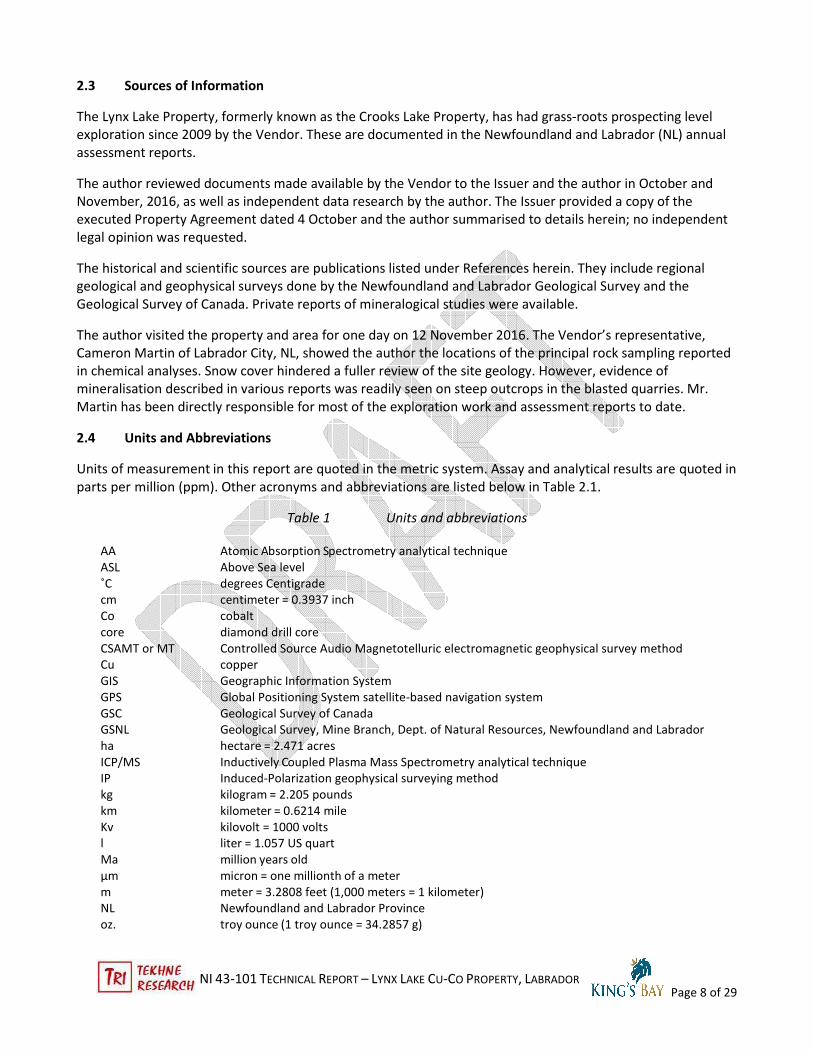
2.4 Units and Abbreviations
Units of measurement in this report are quoted in the metric system. Assay and analytical results are quoted in
parts per million (ppm). Other acronyms and abbreviations are listed below in Table 2.1.
Table 1 Units and abbreviations
AA Atomic Absorption Spectrometry analytical technique
ASL Above Sea level
˚C degrees Centigrade
cm centimeter = 0.3937 inch
Co cobalt
core diamond drill core
CSAMT or MT Controlled Source Audio Magnetotelluric electromagnetic geophysical survey method
Cu copper
GIS Geographic Information System
GPS Global Positioning System satellite-based navigation system
GSC Geological Survey of Canada
GSNL Geological Survey, Mine Branch, Dept. of Natural Resources, Newfoundland and Labrador
ha hectare = 2.471 acres
ICP/MS Inductively Coupled Plasma Mass Spectrometry analytical technique
IP Induced-Polarization geophysical surveying method
kg kilogram = 2.205 pounds
km kilometer = 0.6214 mile
Kv kilovolt = 1000 volts
l liter = 1.057 US quart
Ma million years old
µm micron = one millionth of a meter
m meter = 3.2808 feet (1,000 meters = 1 kilometer)
NL Newfoundland and Labrador Province
oz. troy ounce (1 troy ounce = 34.2857 g)

NI 43-101 TECHNICAL REPORT – LYNX LAKE CU-CO PROPERTY, LABRADOR
Page 9 of 29
ppm parts per million (1 ppm = 1 g/t)
ppb parts per billion (1,000 ppb = 1 ppm)
SEM Scanning Electron Microscope
t metric ton = 1.1023 short tons
ton short ton (= 2000 lbs or 907.2 kilograms)
VLF Very Low Frequency electromagnetic geophysical survey method
Zn zinc
3 RELIANCE ON OTHER EXPERTS
The author relied on data from the Newfoundland and Labrador Mineral Rights Inquiry online reports
reviewed on 21 November 2016 that includes claims registered as recently as 30 days from the search date.
4 PROPERTY LOCATION AND DESCRIPTION
4.1 Location
The Lynx Lake Property consists of 13 Mineral Licenses located approximately 134 km south and east of Happy
Valley-Goose Bay, the regional centre for Labrador, Canada. Highway 510, the only main year-round road in
southeastern Labrador, passes through the north-central part of the property.
Fig. 1 Location of Lynx Lake Property in Labrador, Canada

NI 43-101 TECHNICAL REPORT – LYNX LAKE CU-CO PROPERTY, LABRADOR
Page 10 of 29
4.2 Property Description and Ownership
As of 21 November 2016, the Newfoundland and Labrador Mineral Rights Inquiry online documents that the
Lynx Lakes Property has 13 Mineral Licenses composed of 959 on-line staked mineral claims of 25 hectares
each for a total area of 23,975 ha (23.975 km2). The mineral rights apply to minerals hosted in the bedrock
directly beneath the claim boundaries. The on-line staking procedure means that the claim cells are located on
the government UTM grid NAD 27 across the province of Newfoundland and Labrador and thus there is no
chance for overstaking (duplication of title) or fractional unclaimed areas. No monuments are placed in the
field.
The Vendor, collectively comprising Crook Lake Holdings Ltd., Cameron Martin, and Jeffrey Martin, is the sole
registered claim owner.
Crooks Lake was original property name of the nine mineral licenses (84 claims) as the name of the nearest
named topographical entity. A smaller lake on the St. Augustin River that crosses the property was named Lynx
Lake and that has been adopted by the Issuer and Vendor for the property name. The original license numbers
are correlated with recent license reacquisition and the assignment of the ownership to Crook Lake Holdings
Ltd. These are marked as “same” or the previous license numbers on the table. Subsequent to signing in
October, 2016, an additional four mineral licenses totally 875 claims were mutually included in the Agreement
and are labeled “new” in the table.
The list of mineral licenses and number of claims is shown on Table 2. No legal surveys of the placer claims
have been made on the property.
Table 2 Claims List for Lynx Lake Property
Mineral
License Claims
Issuance
Date Reg. Owner
NTS
Map
NTS
Map
NTS
Map
NTS
Map
pre-Agmt
Min Lic
020271M 14 2012-06-21 Crooks Lake Holdings Ltd 13B/11 Same
020272M 11 2012-06-21 Crooks Lake Holdings Ltd 13B/11 Same
021865M 10 2014-02-20 Crooks Lake Holdings Ltd 13B/11 Same
022238M 5 2014-06-12 Crooks Lake Holdings Ltd 13B/11 Same
022241M 4 2014-06-12 Crooks Lake Holdings Ltd 13B/11 Same
023228M 22 2015-07-30 Crooks Lake Holdings Ltd 13B/11 019380M
023907M 6 2016-05-05 Crooks Lake Holdings Ltd 13B/11 016625M
024065M 6 2016-08-03 Crooks Lake Holdings Ltd 13B/11
016625M
016823M
016824M
024067M 6 2016-08-03 Cameron Martin 13B/12 Same
024424M 242 2016-11-18 Crooks Lake Holdings Ltd 13B/12 13B/05 New
024425M 250 2016-11-18 Crooks Lake Holdings Ltd 13B/11 13B/12 13B/05 13B/06 New
024426M 249 2016-11-18 Crooks Lake Holdings Ltd 13B/11 13B/12 New
024427M 134 2016-11-18 Crooks Lake Holdings Ltd 13B/11 13B/06 New
959 Total Claims
23,975 Area (ha)

NI 43-101 TECHNICAL REPORT – LYNX LAKE CU-CO PROPERTY, LABRADOR
Page 11 of 29
Licenses are granted for five-year periods to a maximum of 20 years. Fees paid every fifth year range from $25
to $100 per claim. Annual assessment work is also required on the claims to maintain their validity with
increasing minimum expenditures ranging from $200 to $400 through the first five years then $600, $900, and
$1200 per claim per year through years 5-10, 10-15, and 15-20 year periods. Technical assessment reports
similar to the NI 43-101 style are required within 60 days after the end of the anniversary date. These are kept
under confidentiality for three years by the Newfoundland and Labrador government.
Figure 2 Claims Map: Lynx Lake Property
NI 43-101 TECHNICAL REPORT – LYNX LAKE CU-CO PROPERTY, LABRADOR
Page 12 of 29
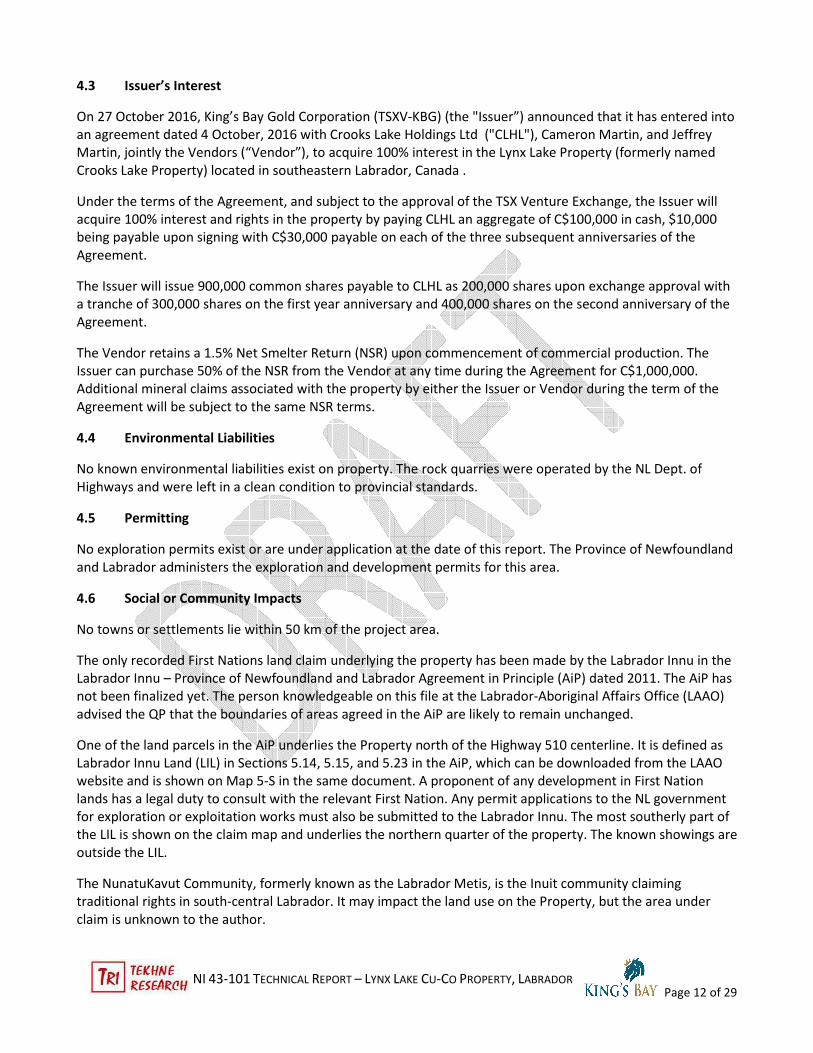
4.3 Issuer’s Interest
On 27 October 2016, King’s Bay Gold Corporation (TSXV-KBG) (the "Issuer”) announced that it has entered into
an agreement dated 4 October, 2016 with Crooks Lake Holdings Ltd ("CLHL"), Cameron Martin, and Jeffrey
Martin, jointly the Vendors (“Vendor”), to acquire 100% interest in the Lynx Lake Property (formerly named
Crooks Lake Property) located in southeastern Labrador, Canada .
Under the terms of the Agreement, and subject to the approval of the TSX Venture Exchange, the Issuer will
acquire 100% interest and rights in the property by paying CLHL an aggregate of C$100,000 in cash, $10,000
being payable upon signing with C$30,000 payable on each of the three subsequent anniversaries of the
Agreement.
The Issuer will issue 900,000 common shares payable to CLHL as 200,000 shares upon exchange approval with
a tranche of 300,000 shares on the first year anniversary and 400,000 shares on the second anniversary of the
Agreement.
The Vendor retains a 1.5% Net Smelter Return (NSR) upon commencement of commercial production. The
Issuer can purchase 50% of the NSR from the Vendor at any time during the Agreement for C$1,000,000.
Additional mineral claims associated with the property by either the Issuer or Vendor during the term of the
Agreement will be subject to the same NSR terms.
4.4 Environmental Liabilities
No known environmental liabilities exist on property. The rock quarries were operated by the NL Dept. of
Highways and were left in a clean condition to provincial standards.
4.5 Permitting
No exploration permits exist or are under application at the date of this report. The Province of Newfoundland
and Labrador administers the exploration and development permits for this area.
4.6 Social or Community Impacts
No towns or settlements lie within 50 km of the project area.
The only recorded First Nations land claim underlying the property has been made by the Labrador Innu in the
Labrador Innu – Province of Newfoundland and Labrador Agreement in Principle (AiP) dated 2011. The AiP has
not been finalized yet. The person knowledgeable on this file at the Labrador-Aboriginal Affairs Office (LAAO)
advised the QP that the boundaries of areas agreed in the AiP are likely to remain unchanged.
One of the land parcels in the AiP underlies the Property north of the Highway 510 centerline. It is defined as
Labrador Innu Land (LIL) in Sections 5.14, 5.15, and 5.23 in the AiP, which can be downloaded from the LAAO
website and is shown on Map 5-S in the same document. A proponent of any development in First Nation
lands has a legal duty to consult with the relevant First Nation. Any permit applications to the NL government
for exploration or exploitation works must also be submitted to the Labrador Innu. The most southerly part of
the LIL is shown on the claim map and underlies the northern quarter of the property. The known showings are
outside the LIL.
The NunatuKavut Community, formerly known as the Labrador Metis, is the Inuit community claiming
traditional rights in south-central Labrador. It may impact the land use on the Property, but the area under
claim is unknown to the author.

NI 43-101 TECHNICAL REPORT – LYNX LAKE CU-CO PROPERTY, LABRADOR
Page 13 of 29
The northern boundary of the property now abuts the southern limit of the Mealy Mountains Exempt Mineral
Lands wherein the land is not available for exploration. This does not directly affect the mineral rights on the
property
4.7 Other Risks
There is a moderate risk to development or exploration access north of Hwy 510 since the Labrador Innu need
to agree to any permit application. Their nascent political and administration structures may not be familiar
with mineral exploration.
There are low to moderate risks associated with executing the technical program recommended in this report.
Water and space for future development are available on and around the property.
No other environmental, social, or community risks are foreseen.
5 ACCESSIBILITY, CLIMATE, LOCAL RESOURCES, INFRASTRUCTURE, AND PHYSIOGRAPHY
5.1 Accessibility
The property is accessible from Happy Valley-Goose Bay, Labrador, the regional centre of Labrador and nearest
airport, by travelling west on Highway 500 nine km to the junction with Highway 510, the Trans-Labrador
Highway and turning left (south) for 125 km to the road into the New Pit south (right/south side) of the
highway. The CA Pit is about 1.6 km further ahead on the right/south side adjacent to the highway. Highways
500 and 510 are all-weather roads paved to about 85 km on Highway 510 from Highway 500 and recently
widened gravel to the east-southeast.
5.2 Climate and Vegetation
The northern boreal forest region receives an extreme range of weather conditions throughout the year.
Summers are short, from June to September with variably dry to wet with local storms, which may give heavy
rainfall. Humidity ranges from very dry to quite humid. Temperatures can reach 30°C with dry winds. Lightning
from thunderstorms is a frequent cause of forest fires, which are a normal hazard in any 20-year period.
Autumn is quite changeable with abrupt shifts from almost summery conditions to frost and back in 48 hours.
As the autumn progresses, colder days are more frequent, and snow may start as early as late September, but
more commonly, snow stays on the ground after mid-Nov. Winter is cold with very short days and
temperatures to -40°C. Snow may come in storms with 50 cm snowfalls. Spring is the opposite of autumn in
the variability of daily temperatures and precipitation. It lasts from April to June. However, frost as well as
above freezing temperatures may occur in any month of the year. Except for the occasional heavy snow fall,
mining operations would not be affected by the climate.
The vegetation is typical boreal to sub-boreal forest. Black spruce and poplars are common larger trees with
willow, tamarack, and alder as shrubs. Understory plants include Labrador tea, a native rhododendron, and
bog laurel. Various mosses and lichens are common especially on sandy glacio-fluvial soils. Valleys are typically
swampy watercourses and string swamps can fill shallow undulations in the topography.
5.3 Local Resources and Infrastructure
The nearest town is the town of Happy Valley-Goose Bay some 134 km by road to the northwest. Some heavy
equipment and operator services are available there, as well as transportation, food, and accommodation.
More complete services, including drilling and mining contractors, are available 500 km to the west in Labrador

NI 43-101 TECHNICAL REPORT – LYNX LAKE CU-CO PROPERTY, LABRADOR
Page 14 of 29
City, Labrador, the regional iron mining centre.
There is no existing power or other facilities, except road access, on the property. The main transmission line
for NALCOR’s Muskrat Falls Hydroelectric Project is under construction across the northern part of the
property about 1.5 km west of the showings and parallels Highway 510.
Figure 3 UAV view above CA Pit to WSW with Muskrat Fall hydro line and St. Augustin River (Photo: UAV May 2016 C. Martin)
Water is available from several lakes near the showings as well as the St. Augustin River that the highway
crosses between the two pits.
5.4 Physiography
The area is generally rolling, forest covered hills with moderate to steep slopes and flatter valleys and tops. It
appears to be a glacial peneplain dissected by glacio-fluvial erosion. Moraine and esker glacial deposits locally
shape the topography as well. Elevations range from 390 m in lakes and valleys to ~500 m on the flat hill tops.

NI 43-101 TECHNICAL REPORT – LYNX LAKE CU-CO PROPERTY, LABRADOR
Page 15 of 29
Figure 4 UAV view above New Pit to ESE
(Photo: UAV May 2016 C. Martin)
6 HISTORY
Prior to October, 2009, no claims were made nor exploration work conducted on the current Lynx Lake
Property. In autumn 2009, after Cameron Martin, who was surveying on the highway crew, found signs of
sulphide mineralisation in the initial road materials quarry, the CA Pit, the initial three mineral licenses
(016625M, 16823M, and 016824M) were acquired by John Martin with his brothers, Cameron and Jeffrey in
late 2009. The property was named Crooks Lake for the nearest named topographic feature about 3 km north.
These are currently held as Licenses 023907M and 024065Mwhich were relocated in summer 2016. Additional
claims were added in 2010-14. The New Pit quarry opened a year later to the west-northwest with similar
mineralisation and the Martin brothers staked two licenses in 2011 (020271M and 020272M) followed by
three more in 2014 (021865M, 022238M, and 022241M) to maintain a contiguous group (see Table 1.) They
conducted prospecting-level exploration works during this period and have filed assessment reports detailing
the results.
Between 2009 and 2014, work on licenses 016625M, 016823M, and 016824M around the original CA Pit
included 45 rock grab samples and seven lines of EM-16 geophysical surveys covering 5,355 ln-m. Eight
samples returned assays with Co ranging 0.2 to 0.57% Co together with Cu ranging from 0.3% (as ppm
analyses) to 1.39% assayed. The EM-16 surveys were mostly oriented Wes-East and returned one strong and
several modest conductor anomalies. Data filtering was done only a few lines, so the strength of possible
conductors in the raw data is difficult to assess for the other lines. In 2014, work was done on license 021865M
east of the CA Pit license; no outcrop was located. Two EM-16 VLF geophysical lines, aligned west-east and
totaling 1,000 m, were surveyed with very weak conductors.

NI 43-101 TECHNICAL REPORT – LYNX LAKE CU-CO PROPERTY, LABRADOR
Page 16 of 29
Figure 5 CA and New Pits on Hwy 510
In 2010-2015, license 020271M where the New Pit is located was the source of 77 samples for Au and 30
element ICP analyses with follow-up assays on higher grade samples of which nine returned Co values 0.125 to
0.4% Co with Cu < 1% by ICP. Additional road material quarrying in 2014 deepened the western half of the
New Pit, exposing abundant sulphide veins and disseminations associated with a “metagabbro” body.
In 20014, two licenses (022238M and 022241M) covering the west and east extensions of the New Pit geology
were tested with two EM-16 VLF geophysics lines for a total of 1,000 m. The license south of the New Pit,
020272M, was prospected without finding any outcrops. Four EM-16 VLF geophysical lines, aligned west-east
and totaling 5,000 m, were surveyed with very weak conductors.
In mid-2015, the brothers formed Crooks Lake Holdings Ltd., and additional licenses were added in 2015 and
2016. Crooks Lake Holdings with Cameron and Jeffrey Martin, jointly named as the vendor, agreed to the sale
of the property, renamed as the Lynx Lake property, to King’s Bay Gold Corp. in October 2016. Subsequent to
the acceptance of the agreement, additional licenses were staked and have been recorded in the NL Mineral
Rights database as of 18 November 2016. No work has been undertaken on the new licenses.
Data on the status of the licenses was verified by the author on 20-21 November 2016 from the NL Minerals
Lands database online.
7 GEOLOLOGICAL SETTING & MINERALISATION
7.1 Regional Geological Setting
Dr. Charles F. Gower of the NL Geological Survey Branch and his associates have been the principal mappers
and researchers in the eastern Labrador sector of the Grenville Province since 1984. The Grenville Province
extends from the Atlantic coast west and southwest for over 2,000 km and has affected the terranes that
NI 43-101 TECHNICAL REPORT – LYNX LAKE CU-CO PROPERTY, LABRADOR
Page 17 of 29
assembled the southeasterly margin of the pre-Rhodinia Laurentian craton. The Grenville orogeny was the last
of four major orogenies that occurred from about 1,100 to 950 Ma and affected the older terranes. The
Grenville Orogeny formed a long mountain chain likened to the modern Himalaya Mountains. The exhumed
deep orogenic roots are expressed in highly metamorphosed sedimentary and volcanic rocks as well as older
intrusive granite and gabbro type rocks. Interpretation of the pre-Grenville history is complicated by the
intense metamorphism and structures generated in part by the Grenville compressional events. The
recrystallisation and partial melting of sedimentary rocks mimics metamorphosed plutonic intrusions, leading
to a range of petrographic descriptions and interpretations. Gower (1999, 2001) discusses these issues.
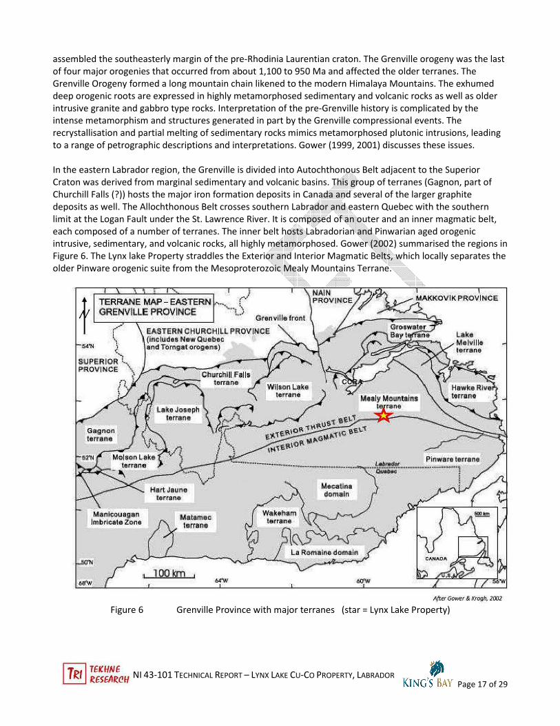
In the eastern Labrador region, the Grenville is divided into Autochthonous Belt adjacent to the Superior
Craton was derived from marginal sedimentary and volcanic basins. This group of terranes (Gagnon, part of
Churchill Falls (?)) hosts the major iron formation deposits in Canada and several of the larger graphite
deposits as well. The Allochthonous Belt crosses southern Labrador and eastern Quebec with the southern
limit at the Logan Fault under the St. Lawrence River. It is composed of an outer and an inner magmatic belt,
each composed of a number of terranes. The inner belt hosts Labradorian and Pinwarian aged orogenic
intrusive, sedimentary, and volcanic rocks, all highly metamorphosed. Gower (2002) summarised the regions in
Figure 6. The Lynx lake Property straddles the Exterior and Interior Magmatic Belts, which locally separates the
older Pinware orogenic suite from the Mesoproterozoic Mealy Mountains Terrane.
Figure 6 Grenville Province with major terranes (star = Lynx Lake Property)
NI 43-101 TECHNICAL REPORT – LYNX LAKE CU-CO PROPERTY, LABRADOR
Page 18 of 29
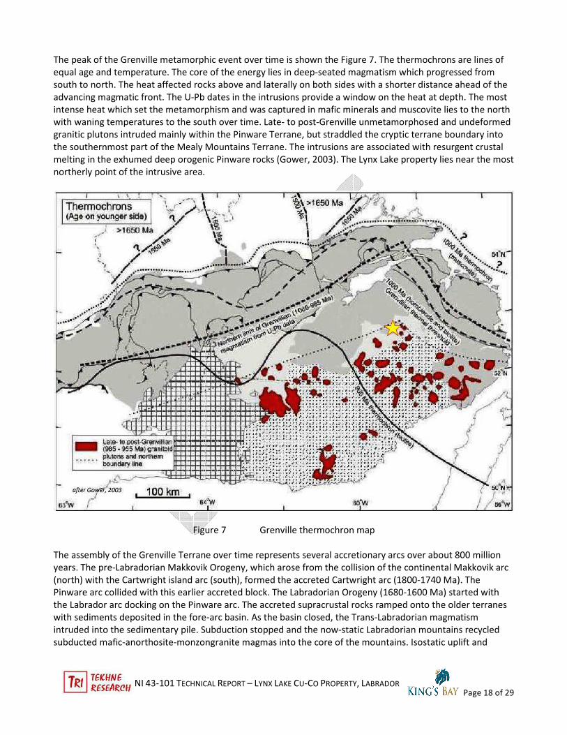
The peak of the Grenville metamorphic event over time is shown the Figure 7. The thermochrons are lines of
equal age and temperature. The core of the energy lies in deep-seated magmatism which progressed from
south to north. The heat affected rocks above and laterally on both sides with a shorter distance ahead of the
advancing magmatic front. The U-Pb dates in the intrusions provide a window on the heat at depth. The most
intense heat which set the metamorphism and was captured in mafic minerals and muscovite lies to the north
with waning temperatures to the south over time. Late- to post-Grenville unmetamorphosed and undeformed
granitic plutons intruded mainly within the Pinware Terrane, but straddled the cryptic terrane boundary into
the southernmost part of the Mealy Mountains Terrane. The intrusions are associated with resurgent crustal
melting in the exhumed deep orogenic Pinware rocks (Gower, 2003). The Lynx Lake property lies near the most
northerly point of the intrusive area.
Figure 7 Grenville thermochron map
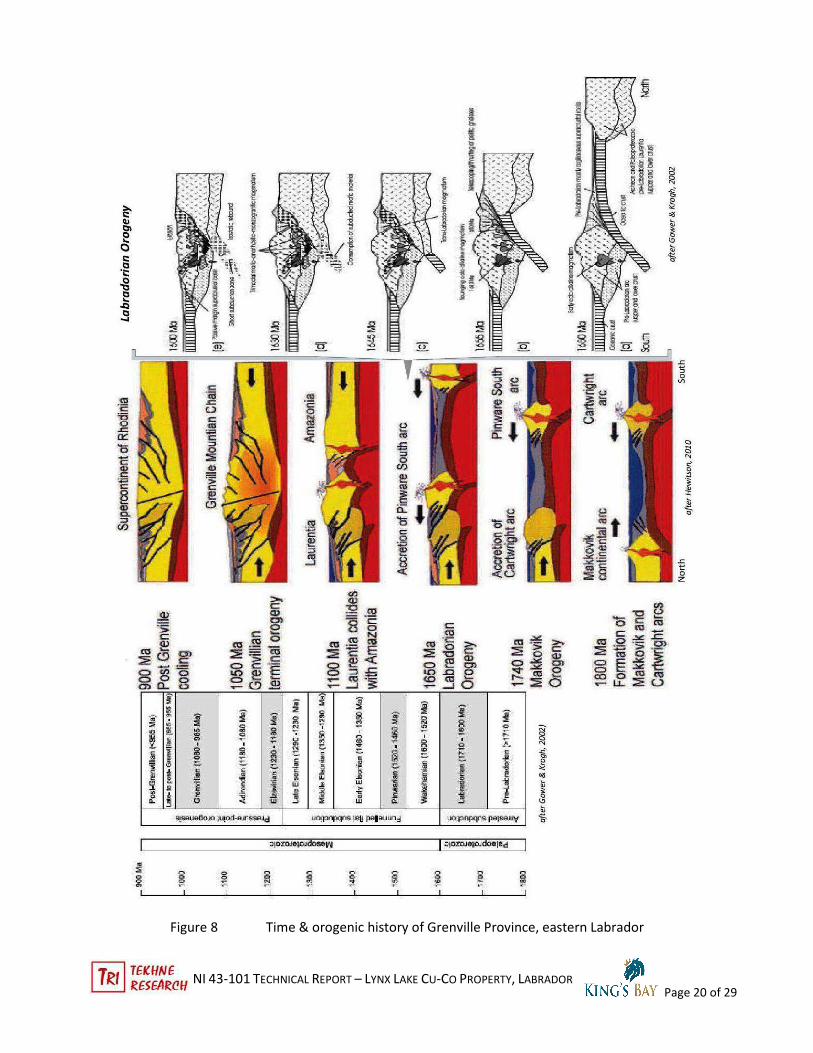
The assembly of the Grenville Terrane over time represents several accretionary arcs over about 800 million
years. The pre-Labradorian Makkovik Orogeny, which arose from the collision of the continental Makkovik arc
(north) with the Cartwright island arc (south), formed the accreted Cartwright arc (1800-1740 Ma). The
Pinware arc collided with this earlier accreted block. The Labradorian Orogeny (1680-1600 Ma) started with
the Labrador arc docking on the Pinware arc. The accreted supracrustal rocks ramped onto the older terranes
with sediments deposited in the fore-arc basin. As the basin closed, the Trans-Labradorian magmatism
intruded into the sedimentary pile. Subduction stopped and the now-static Labradorian mountains recycled
subducted mafic-anorthosite-monzongranite magmas into the core of the mountains. Isostatic uplift and

NI 43-101 TECHNICAL REPORT – LYNX LAKE CU-CO PROPERTY, LABRADOR
Page 19 of 29
erosion exhumed the Labradorian mountains by about 1600 Ma. Hewitson (2010) hypothesized that the Trans-
Labradorian zone comprises one supracrustal block based on Nd isotope data.
After a 500 Ma hiatus, the Grenville Orogeny started with the collision of the Amazonia and Laurentia cratons.
Grenville orogenesis started about 1085 Ma and ended around 945 Ma. The suturing of the two cratons was
part of the formation of the supercontinent Rhodinia. Late granitic and mafic intrusions occurred in the cool-
down phase of the orogeny. Figure 8 illustrates these relations.
NI 43-101 TECHNICAL REPORT – LYNX LAKE CU-CO PROPERTY, LABRADOR
Page 20 of 29
Figure 8 Time & orogenic history of Grenville Province, eastern Labrador

NI 43-101 TECHNICAL REPORT – LYNX LAKE CU-CO PROPERTY, LABRADOR
Page 21 of 29
The regional residual aeromagnetic map (Figure 9) shows the general contrast between the Mealy Mountains
and Pinware Terranes. In detail, there is local variability due to the presence of more mafic intrusives and
plutons in both terranes. Interestingly, the late M3 granite and syenite intrusions have pronounced magnetic
signatures. Possibly the Fe content, while generally low in these rocks, could be all converted to magnetite in a
reducing environment. Even with an natural 1-2.5% Fe component in granite, the magnetics would show a
moderate to strong contrast. An example of this process is the magnetic Archean Kam-Kotia rhyolite, near
Timmins, Ontario, that has normal calc-alkaline chemistry, including ~1.5% total Fe. The rock is magnetic to a
hand-held pencil magnet and the hill was used as a magnetic calibration point for airborne mag surveys in the
1970s. Interestingly, the M1 amphibolite unit mapped north of the MMIS-Pinware terrane boundary shows
lower magnetic contrast than do the late granitic plutons.
Figure 9 Residual Aeromagnetic map
MMIS = Mealy Mountain Intrusive Suite PINWARE = Pinware Terrane

NI 43-101 TECHNICAL REPORT – LYNX LAKE CU-CO PROPERTY, LABRADOR
Page 22 of 29
7.2 Property Geology
7.2.1 Stratigraphy
Gower (1999, 2001) noted that the area on NTS sheets 13B/11, 12 and the northern parts of 05 and 06 around
the property have very little outcrop exposure. The few units tough enough to resist glacial erosion, such as
pegmatite and meta-quartzite, likely form only a small portion of actual lithologic volume.
The general geology around the property is illustrated in Figure 10. It straddles the cryptic Mealy Mountains –
Pinware boundary. Gower (1999, 2003) used the term “cryptic” since the rocks on both terranes looks quite
similar. However, the radiometric ages show the Pinware as somewhat older, consistent with the accretionary
model in Figure C. Subtle petrographic characteristics can help distinguish the two terranes. But the
coalescence of the two into one supracrustal entity, demonstrated by Hewitson (2010) makes field distinctions
difficult.
The distinction of potential economic merit is between the pre- and post-Grenville units. Gower (1999, 2001,
2010) suggests that “gabbro” was emplaced in late or even post-Grenville time (< 900 Ma). No age-dating
confirms this, but the very limited outcrop data suggests the possibility, at least for a few places, including the
Lynx Lake pits. The property area includes late Grenville undeformed and unmetamorphosed granite bodies
and possibly equivalent gabbro dykes.
Figure 10 shows the grosser units. However, the host for mineralisation appears to be associated with local-
scale intrusions.
7.2.2 Structure
No proper geological mapping of the property or even the two pit showings has been done to date. The
author’s noted on the one-day site visit that there were some trends readily visible. These were essentially E-
W trends of the mafic dyke (?) contacts and associated foliation of adjacent granitoid rocks. Young
micropegmatite “injection” veins in the granitoid and gabbro appeared to be oriented roughly N-S with
shallow east and west dips and anastomosing “vein” relationships. The gabbro hosted sheeted joints with one
principal direction parallel to the contacts and dipping steeply to the south (dominant) and north (less
frequently). Other directions may be present but the snow cover precluded a more detailed assessment. It is
interesting to note that the intrusive contacts, based on limited information, are oriented about 30° east of the
general unit alignment as shown on Gower’s 2010 map.
7.2.3 Metamorphism
The metamorphic grade around the property is middle to upper amphibolite facies for the MMIS and Pinware
lithologies. The late- to post-Grenville granitoids show no deformation or metamorphism (Gower, 1999, 2001).

NI 43-101 TECHNICAL REPORT – LYNX LAKE CU-CO PROPERTY, LABRADOR
Page 23 of 29
Figure 10 Lynx Lake Property Geology (after Gower, 2001 & 2010)
MMIS = Mealy Mountains Intrusive Suite ; M3 units are late to post-Grenville undeformed granitoid intrusives;
Dash contact is cryptic boundary between Pinware and MMIS terranes.
7.2.4 Alteration & Mineralization
Sulphide mineralisation is similar in the two showings. Medium to coarsely crystallised sulfides occurs with
quartz, orthoclase/plagioclase, and minor muscovite in planar veins occupying straight joint sets in the gabbro
and less so in the adjacent granitoid host rocks. Sulphides are also disseminated in the gabbro and appear in
hand lens to be interstitial to the silicate minerals, suggesting a co-development; disseminations are less
common in the flanking granitoids, but how extensive they continue is uncertain. Locally, segregations of
magnetite and sulphides occur in the gabbro. The two observed by the author were close to contacts with
granitoid host. Cameron Martin says several high-magnetite samples were informally analyzed at the Iron Ore

NI 43-101 TECHNICAL REPORT – LYNX LAKE CU-CO PROPERTY, LABRADOR
Page 24 of 29
of Canada mine laboratory in Labrador City, NL, where he works, and they returned around 45% Fe, which
translates to ~30% magnetite, assuming all the analysed Fe was in magnetite. The extent of this mineralisation
is unknown, but the regional aeromagnetic map shows a mag low at the New Pit and average at the CA Pit; the
late intrusives show stronger magnetic signatures.
The one petrographic samples sent by Altius (2013) for scanning electron microscope (SEM) analysis by Dr.
Derek Wilton of Memorial University of Newfoundland (MUN) and three polished thin section sent by Callinan
Royalties (2014) to Jean-Luc Pilote, MSc at MUN yielded similar information regarding the sulphide minerals.
The SEM sample location was unknown to Wilton. It was massive sulphides with >90% pyrite and lesser
amount of chalcopyrite and magnetite inclusions. Tiny blebs of pyrrhotite were in the pyrite and magnetite
grains, while minor tiny inclusions of sphalerite were in chalcopyrite. No cobalt-bearing mineral phases were
detected. The form of the grains suggested that there was some post-deposition deformation with minor
chalcopyrite + sphalerite remobilization. No silicate gangue minerals were in the sample.
The three petrographic sections were from samples taken by Cameron Martin in the CA Pit. The host rock
appears to be hornblendite. Minor sericite veinlets were noted, but the primary minerals appear fresh. The
sulphides occurred in veins and disseminations. The interlocking textures showed the primary sulphide was
pyrite with blebby chalcopyrite and magnetite. Blobs over 0.6 mm of magnetite had inclusions of chalcopyrite
and pyrite with less pyrrhotite blebs and prismatic rutile grains. The sense was that the opaque minerals were
deposited at the same time. The sulphide mineralisation does not extend into the sericite veinlets.
The location of the cobalt in the minerals remains unclear. It probably is dissolved in pyrite or chalcopyrite. The
samples with 0.2 to 0.94% Co do not correlate directly with Cu grades, although that sample set is small. More
selective sampling needs to be done to ascertain whether Co is preferentially associated with early
disseminations or later vein sulphides.
Alteration is localized around the later veins. The two petrographic sections (CAPiT-1 and -2) with host rocks
show discrete small sericite veinlets with minor epidote, but no calcite. The joint-related sulphide veins in the
New Pit show alteration rinds 1-3 mm wide with pinkish very fine grained minerals. Otherwise the host rocks in
both areas appear unaltered.
8 DEPOSIT TYPE
The Lynx Lake sulphide deposits do not appear to be related to major models of sulphide deposits. These have
formed in amphibolite host intrusions into granitoids.The sulphides may have formed fine-grained
disseminations in the mafic magma or were deposited into the intrusions at high temperatures during the
waning Grenville thermochron around 900 Ma. They appear to have been deposited contemporaneously
rather than as overprints. The fluids may have arisen from the nearby young M3 granitoids. Remobilisation and
associated weak sericite alteration formed coarser veinlets and veins localised along post-cooling joint
fractures. The late sulphide mineralisation extends into the host granitoids, likely as a halo, that affects late
micropegmatite veins that often carry coarse sulphides as well. The magnetite-sulphide-rutile lenses appear to
be small-scale.
The minor minerals in the magnetite-rutile lenses include pyrrhotite and chalcopyrite, which suggests a lower
oxygen environment, while the pyrite-chalcopyrite-sphalerite (and occasional molybdenite flakes) form in a
more oxygenic context.
The location of cobalt in the system may be a function of the age (primary or secondary) of the deposition. The
current data does not permit an analysis of the different sulphide loci.

NI 43-101 TECHNICAL REPORT – LYNX LAKE CU-CO PROPERTY, LABRADOR
Page 25 of 29
9 EXPLORATION
No exploration has been done by the Issuer. All information by the Vendor is discussed in Section 6 -
History.
10. DRILLING
As of the report date, neither the Vendor nor the Issuer has undertaken any drilling on the Lynx Lake Property.
11 SAMPLE PREPARATION, ANALYSES AND SECURITY
No samples have been taken by the Issuer as of the date of this report.
12 DATA VERIFICATION
Per Section 11, not applicable
13 MINERAL PROCESSING & METALLURGICAL TESTING
Not applicable
14 MINERAL RESOURCE ESTIMATES
Not applicable
15 MINERAL RESERVE ESTIMATES
Not applicable
16 MINING METHODS
Not applicable
17 RECOVERY METHODS
Not applicable
18 PROJECT INFRASTRUCTURE
Not applicable.
19 MARKET STUDIES AND CONTRACTS
Not applicable
20 ENVIRONMENTAL STUDIES, PERMITTING, AND SOCIAL OR COMMUNITY IMPACTS
Not applicable.
21 CAPITAL AND OPERATING COSTS
Not applicable

NI 43-101 TECHNICAL REPORT – LYNX LAKE CU-CO PROPERTY, LABRADOR
Page 26 of 29
22 ECONOMIC ANALYSIS
Not applicable
23 ADJACENT PROPERTIES
On NTS sheets 13/B 11 & 12, five separate small mineral licenses with a total of 30 claims (750 ha) abut the
Lynx Lake Property. These are held by Ricky Edmunds of Postville, Labrador and were recorded on 15
November 2016. The small mineral license 024067M in the centre of license 024424M is part of the Lynx lake
Property.
Figure 11 Lynx Lake Property and adjacent mineral licenses
24 OTHER RELEVANT DATA AND INFORMATION
There are no additional data or material information known to the author about the subject property as of the
date of this report.

NI 43-101 TECHNICAL REPORT – LYNX LAKE CU-CO PROPERTY, LABRADOR
Page 27 of 29
25 INTERPRETATION AND CONCLUSIONS
25.1 Interpretation
The Lynx Lake Property has two substantial showings of disseminated and vein sulphides with Cu and Co values
to 1.39% Cu and 0.94% Co. The work by the Vendor from 2009 to 2016 has been at the prospection level. The
results are promising and future work needs to resolve some key questions. What is known of the deposits
does not fit any broad model of Cu-Co deposits.
One issue is documenting the geological details in and around the existing pits. This requires detailed mapping
with structural measurements by a senior field geologist. Prospection by the Vendor did not find any other
outcrop, so use of an excavator should be useful.
Another is determination of the age of sulphide deposition that contains the Cu and Co. This can be done by
detailed sampling of the various sulphide types both in the amphibolite and the adjacent rocks. If the better
sulphides are in the disseminated sulphides, geophysical techniques, such as induced polarization (IP), would
be the preferred method. If the veins are more prospective, they would form conductors and electromagnetic
survey (EM) methods would be better. Past geophysical surveys by the Vendor were for conductors but done
on lines aligned east-west, which appears to be the principal direction of the veins.
25.2 Conclusions
The Cu-Co potential of the Lynx Lake showings has shown potential which can only be developed by focused
technical geological and geophysical works in order to justify a drilling program.
25.3 Risks
The Lynx Lake Property is a green-fields project with prospection-level development to date. There is a risk
that future exploration may not locate a viable Cu or Co deposit. The risks are the normal geological ones
including: the presence of repeatable grades of Cu and Co in the rock, their continuity and connections to
establish a deposit of sufficient size and grade, and the technical processing methods to produce a marketable
product.
Other risks can include (from moderate to low): establishing a positive relationship and agreements with the
First Nations owners of the lands (Labrador Innu and possibly the NunatuKavut Community), access to water
rights for production and processing; permits for surface rights for production, processing and tailings, access
to adequate power and other infrastructure requirements for development and processing.
26 RECOMMENDATIONS
The author recommends a two-phase work program with further works dependent on results. Phase 1 would
focus on developing the geological and mineralogical knowledge to design appropriate geophysical surveys to
guide Phase 2 drilling. The proposed work includes:
(1) detailed geological mapping of the showings and their extensions developed by trenching;
(2) detailed sampling of the several types of sulphide types (dissemination, veins) and petrographic studies to
determine the mineralogy
(3) channel sampling to determine the bulk grades in showings
(4) design and execute appropriate geophysical surveys to test extension of the showings as well as determine

NI 43-101 TECHNICAL REPORT – LYNX LAKE CU-CO PROPERTY, LABRADOR
Page 28 of 29
property-wide prospection methods.
The Phase 1 program as laid out would provide a sound knowledge platform for selecting drill holes in Phase 2.
Phase 1 ($ 72,500)
1 Geological mapping, trenching, $ 12,500
2 Detailed sampling & petrography $ 16,000
3 Channel sampling $ 14,000
4 Geophysical surveys (type TBD) $ 30,000
Total $ 72,500
Proposed Phase 2 works would focus on drilling to test targets defined in Phase 1. Three pairs of inclined
diamond drill holes on three sections on each showing would test to a depth 50 m with 75-m long holes. The
cost includes technical and analytical support.
Phase 2 ($ 236,000)
1. Drill 6 holes on CA Pit (total 450 m) $ 118,000
2. Drill 6 holes on CA Pit (total 450 m) $ 118,000
Total $ 236,000
Currency is CAD plus applicable taxes. No contingency allowance was used, although it is prudent to do so.
27 REFERENCES
Gower, C.F., 1999.Geology of the Crooks Lake map region, Grenville Province, eastern Labrador. NL Dept.
Mines & Energy, Geol Surv, current research 1999, rept 99-1, pp 41-58
Gower, C.F., 2001. Geology of the Upper St. Augustin River map area, Grenville Province, eastern Labrador. NL
Dept. Mines & Energy, Geol Surv, current research rept 2001-1, pp 23-43
Gower, C.F., 2003. Implications of re-assessed 40Ar/39Ar and K/Ar geochronological data for Grenvillian
orogenesis in the eastern Grenville Province. NL Dept. Mines & Energy, Geol Surv, current research 2003, rept
2003-1, pp 15-33
Gower, C.F., 2010. Geology of the Crooks Lake area (NTS sheets 13B/11, 12, 13, and 14), southeastern
Labrador. NL Dept. Mines & Energy, Geol Surv, Open File 013B/0027, Map 2010-17, 1 poster-map.
Gower, C.F., S.L. Kamo, K.Kwok, T.E. Krogh, 2008. Proterozoic southward accretion and Grenville orogenesis in
the interior Grenville Province in eastern Labrador: Evidence from U-Pb geochronological investigations.
Precambrian Res, v 165, iss 1-2, pp 61-95
Gower, CF, and T.E. Krogh, 2003. A U-Pb geochronological review of the Proterozoic history of the eastern
Grenville Province. CJES, v 39, no 5, pp 795-829
Heaman, L.M., C.F. Gower, S. Perrault, 2004. The timing of Proterozoic magmatism in the Pinware Terrane of
southeast Labrador, easternmost Quebec, and northwest Labrador. CJES, v 41, no 4, pp 127-150

NI 43-101 TECHNICAL REPORT – LYNX LAKE CU-CO PROPERTY, LABRADOR
Page 29 of 29
Hewitson, M.R., 2010. Nd-isotope mapping of the Grenville Province on southern Labrador. McMaster Univ,
Dept. of Earth Sciences, M.Sc. thesis, 107p
Wasteneys, H.A., S.L. Kamo, D. Moser, T.E. Krogh, C.F. Gower, J.V. Owen, 1997. U-Pb geochronological
constraints on the geological evolution of the Pinware Terrane and adjacent areas, Grenville Province,
southeast Labrador, Canada. Precambrian Res, v 81, iss 1-2, pp 101-128