Embed Size (px)
Citation preview
ã2017CaliforniaInstituteofTechnology.Governmentsponsorshipacknowledged.
NISAR:TheNASA-ISROSARMission
OilSpills:FrequentandCostlyAccidentsIn 2010, the Deepwater Horizon oil spill released anestimated210milliongallonsofoilintotheGulfofMexicoover a period of 86 days; the largest accidental spill inhistory. Though this spillwas remarkable for itsextent,
releasevolume,andduration,spillsarenotaninfrequentoccurrence:EveryyeartheU.S.respondstohundredsofoilandchemicalspillswithinitsbordersandtotheinfluxofoilspreadherefromspillsoutsideourwaters.
ProtectingWater,Land,andPeoplefromOilSpills
Everyyear,emergencyrespondersworktopreventhundredsofoilandchemicalspillsfromharmingpeopleandtheenvironment.Rapididentificationofspilledoilinthevastopenwatersoftheoceansandgulfiskeytominimizingdamage,andradarremotesensingcanprovidethenecessaryinformation.
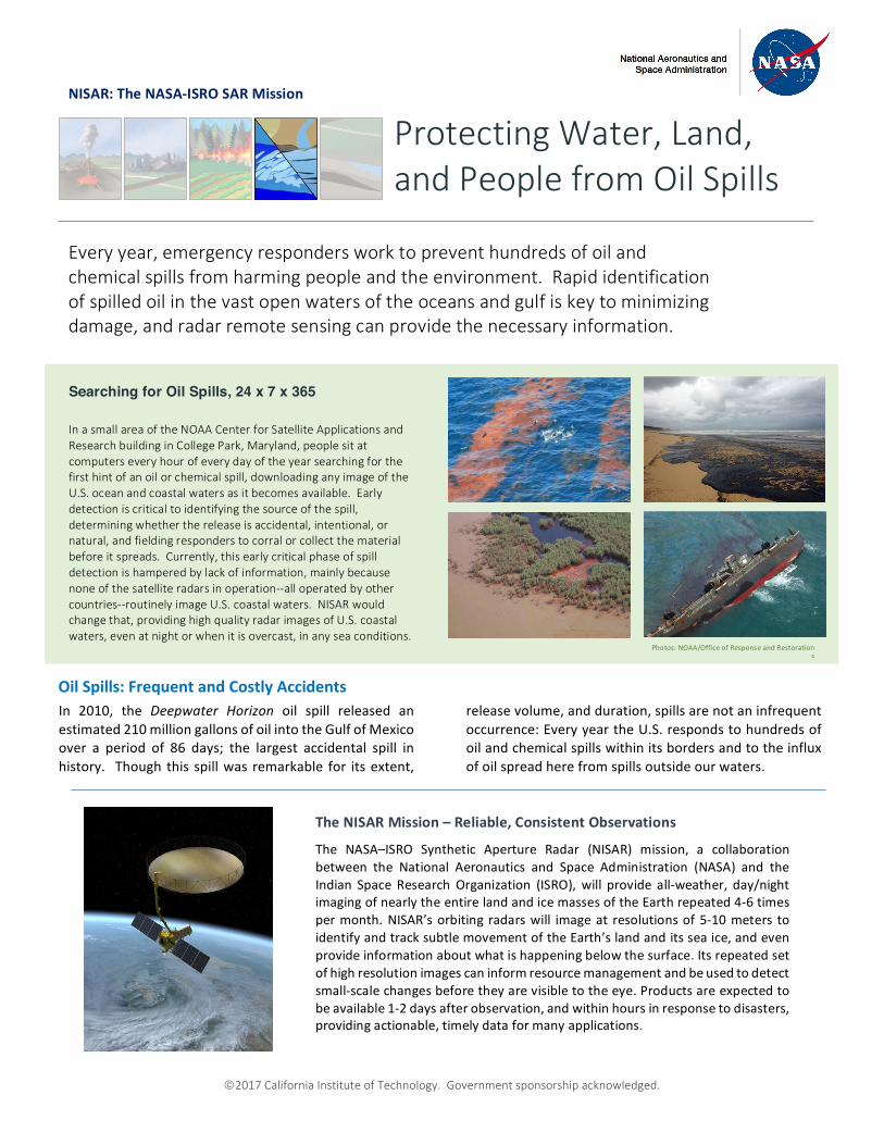
Searching for Oil Spills, 24 x 7 x 365
InasmallareaoftheNOAACenterforSatelliteApplicationsandResearchbuildinginCollegePark,Maryland,peoplesitatcomputerseveryhourofeverydayoftheyearsearchingforthefirsthintofanoilorchemicalspill,downloadinganyimageoftheU.S.oceanandcoastalwatersasitbecomesavailable.Earlydetectioniscriticaltoidentifyingthesourceofthespill,determiningwhetherthereleaseisaccidental,intentional,ornatural,andfieldingresponderstocorralorcollectthematerialbeforeitspreads.Currently,thisearlycriticalphaseofspilldetectionishamperedbylackofinformation,mainlybecausenoneofthesatelliteradarsinoperation--alloperatedbyothercountries--routinelyimageU.S.coastalwaters.NISARwouldchangethat,providinghighqualityradarimagesofU.S.coastalwaters,evenatnightorwhenitisovercast,inanyseaconditions.
TheNISARMission–Reliable,ConsistentObservations
The NASA–ISRO Synthetic Aperture Radar (NISAR) mission, a collaborationbetween the National Aeronautics and Space Administration (NASA) and theIndian Space Research Organization (ISRO), will provide all-weather, day/nightimagingofnearlytheentirelandandicemassesoftheEarthrepeated4-6timespermonth.NISAR’sorbitingradarswill imageat resolutionsof5-10meterstoidentifyandtracksubtlemovementoftheEarth’slandanditsseaice,andevenprovideinformationaboutwhatishappeningbelowthesurface.Itsrepeatedsetofhighresolutionimagescaninformresourcemanagementandbeusedtodetectsmall-scalechangesbeforetheyarevisibletotheeye.Productsareexpectedtobeavailable1-2daysafterobservation,andwithinhoursinresponsetodisasters,providingactionable,timelydataformanyapplications.
Photos:NOAA/OfficeofResponseandRestorationS

ã2017CaliforniaInstituteofTechnology.Governmentsponsorshipacknowledged.
Cont.fromfrontpage
During the Deepwater Horizon spill, the InternationalCharter, “Space andMajor Disasters”, was activated toprovide satellite-based Earth Observation data by thespaceagenciesofallparticipatingnations,tosupportthedisaster response effort in the United States. Thisworldwidecollaborationacquiredandmadeavailabletheradardatausedtotracktheoilasitsurfacedandspreadin the Gulf of Mexico. The radar data was invaluablebecauseradar,whichemitsitsownenergypulsesinsteadof relying on scattered sunlight, could see below thecloudstoeasily identifytheoilslickonthesurface. Oildamps the small-scale roughness of the water surface,reducing the amount of energy backscattered into theradar antenna. This makes it very easy to detect oil,
because it showsup in radar images as very dark areaswithinthebrightercleanwater.Without the radar data provided by the InternationalCharter, available only duringmajor disasters forwhichthecharterisactivated,theU.S.wouldnothavebeenabletotrackthespillnearlyasquicklyandwithoutpayingfortheimages.NISARwill change this situation. NISARwill be able toacquire images of U.S. coastalwaters on every satellitepassovertheentireborderoftheUnitedStates,sothatwenotonlyhavethedataduringanemergency,butcanidentifythespillsearlier.Thiswillimproveresponsetimeandeven,forcasesofintentionalspillsmadefromships,identifyandmorereadilyapprehendthoseresponsible.
NationalAeronauticsandSpaceAdministrationFormoreinformation,visithttp://nisar.jpl.nasa.gov/applications
JetPropulsionLaboratory/CaliforniaInstituteofTechnology/Pasadena,California/www.jpl.nasa.gov
EarthobservationsfromspaceusingtheNISARradarinstrumentwillenablereliableandrepeatedmeasurementstobemadeofthecoastalandinlandlargewater bodiesof theUnitedStates, all ofwhich are sitesof frequentaccidentalorintentionaloilspills.CoastlineswillbeimagedbyNISAReverysixdays.Oilslicksareparticularlyeasytoidentifyusingradar,becausetheyshowupasdarkfeatures,asisshownin thefiguretotheright.Itisevenpossibletoidentifylargerslicksonlandincaseswheretheyformsmooth-surfacedpuddlesthatcanberesolvedfromspace.Oceanographershavelongusedradartostudyoceanwavespectra,whichgives details about the ripples on the ocean surface. Today, studies areunderwaytorelatethechangesinwavespectratotheamountortypeofoilpresentonthewatersurface.Inthisway,radarcouldbeusedtogobeyonddetectionofslicks, toidentifywhereoil isconcentratedwithintheslick inordertodirectclean-upactivitiesevenmoreeffectively.. Right:RadarimageofoilfromtheDeepwaterHorizonspillnearingthebeach
ofsoutheasternLouisiana.Theoilslickshowsupasadarkareaintheopenwater,andinthisfalsecolorimage,theslick-freewaterisblue/purpleincolor.Oilsmoothsthewatersurface,reducingthebackscatteredenergy,makingiteasytoidentifyslicksonopenwaterwithradar.ThisimagewasacquiredwithUAVSAR,whichistheprototypeairborneinstrumentforNISAR[modifiedfromJonesetal.,2011].
Radar Imaging of Oil-on-Water
Below:Photographsofspillsandtheirimpact.Credit:NOAAResponseandRestorationOffice,DHS