Embed Size (px)
Citation preview
i
Nisqually Watershed Response to the 2018 Streamflow Restoration Act
(RCW 90.94)
Addendum to the Nisqually Watershed Management Plan
Prepared for the Nisqually Indian Tribe and Nisqually Watershed Planning Unit
January 16, 2019
With Assistance from: Ecology Grant No. WRSRPPG-2018-NisqIT-00014
RecommendedCitation:NisquallyWatershedPlanningUnit(2019).NisquallyWatershedResponsetothe2018StreamflowRestorationAct(RCW90.94):AddendumtotheNisquallyWatershedManagementPlan.Olympia,WA.

WRIA11StreamflowRestorationAddendum
ii
Acknowledgements ThisAddendumtotheNisquallyWatershedPlanwasdevelopedthroughtheparticipationandinputofnumerous
stakeholdersfromtheNisquallyWatershedoverthepastyearinarapidresponsetothemandateofthe
StreamflowRestorationAct(chapter90.94RCW).Wearegratefulfortheexpertiseandresponsivenessofthese
PlanningUnitmembers:
PLANNING UNIT: GaryBahr–DepartmentofAgricultureJesseBarham–CityofOlympiaGrantBeck–CityofYelmDanCardwell–PierceCountyTomCulhane–DepartmentofEcologyMatthewCurtis–DepartmentofFish&WildlifeJoshuaCummings–ThurstonCountyJeffDickison–SquaxinIslandTribeFredEvander–LewisCountyWillieFrankIII–NisquallyIndianTribeMikeGallagher–DepartmentofEcologyKizaGates–DepartmentofFish&WildlifeMichaelGrayum–CityofYelmAbbyGribi–TownofEatonvilleJessicaGwilt–PierceCountyDennisHanberg–PierceCountyKevinHansen–ThurstonCountyJustinHall–NisquallyRiverFoundationAndyHaub–CityofOlympiaTomKantz–PierceCountyLeeNapier–LewisCountyRussellOlsen–ThurstonPublicUtilityDistrictAllisonOsterberg–ThurstonCountyJulieRector–CityofLaceyJoeRoush–CityofOlympiaJamesSlape–NisquallyIndianTribeRanceSmith–PierceCountyBarbaraAnnSmolko–PierceCountyGaryStamper–LewisCountyDavidTroutt–NisquallyIndianTribeGeorgeWalter-NisquallyIndianTribeLoisWard–NisquallyRiverCouncilCACJohnWeidenfeller–ThurstonPublicUtilityDistrictCynthiaWilson–ThurstonCounty
WORK GROUPS: WATERFORECASTWORKGROUP:DanCardwell–PierceCountyTomCulhane–DepartmentofEcologyLisaDallyWilson–DallyEnvironmentalFredEvander–LewisCountyMikeGallagher–DepartmentofEcologyAllisonOsterberg–ThurstonCountyRanceSmith–PierceCountyGeorgeWalter–NisquallyIndianTribeJohnWeidenfeller–ThurstonPublicUtilityDistrictHABITATPROJECTWORKGROUP:MattBarnhart–PierceCountyLisaDallyWilson–DallyEnvironmentalChrisEllings–NisquallyIndianTribeJustinHall–NisquallyRiverFoundationKevinHansen–ThurstonCountySayreHodgson–NisquallyIndianTribeTomKantz–PierceCountyEmilyMcCartan–NisquallyRiverFoundationAllisonOsterberg–ThurstonCountyDavidTroutt–NisquallyIndianTribeAshleyVonEssen–NisquallyIndianTribeOTHERSTRATEGIESWORKGROUPGrantBeck–CityofYelmLisaDallyWilson–DallyEnvironmentalAbbyGribi–TownofEatonvilleKevinHansen–ThurstonCountyTomKantz–PierceCountyEmilyMcCartan–NisquallyRiverFoundationDaveNazy–EAEngineering,Science,&Technology,Inc.AllisonOsterberg–ThurstonCountyRanceSmith–PierceCountyBarbaraAnnSmolko–PierceCountyGaryStamper–LewisCountyGeorgeWalter–NisquallyIndianTribeJohnWeidenfeller–ThurstonPublicUtilityDistrict
PLANNINGUNITSUPPORTGeorgeWalter,NisquallyIndianTribe–PlanningUnitLead
LisaDallyWilson,DallyEnvironmental–FacilitatorandProjectManager
EmilyMcCartan,NisquallyRiverCouncil–HabitatWorkGroupLiaisonandStaffingSupport
WRIA11StreamflowRestorationAddendum
iii
Contents
ListofTables................................................................................................................................................................viiListofFigures................................................................................................................................................................ixListofAppendices..........................................................................................................................................................xListofAcronyms...........................................................................................................................................................xiExecutiveSummary.....................................................................................................................................................xii
Introduction.............................................................................................................................................................xiiPlanAddendumOrganization.................................................................................................................................xiiiSummaryofResults................................................................................................................................................xiii
Chapter1 IntroductionandBackground...............................................................................................................1-11.1 NisquallyWatershedPlanningandtheHirstResponse...............................................................................1-11.2 ScopeofthisAddendumandAgreements..................................................................................................1-11.3 Sub-BasinDelineation..................................................................................................................................1-31.4 EstablishedInstreamFlowsinWRIA11.......................................................................................................1-41.5 NisquallyApproachtoMitigation................................................................................................................1-41.6 FundingforMitigation.................................................................................................................................1-5
Chapter2 WatershedFeaturesthatInfluenceMitigationAlternatives................................................................2-62.1 WatershedOverviewintheContextofMitigation......................................................................................2-62.2 WatershedHydrologyandGeology.............................................................................................................2-62.3 Sub-BasinCharacteristics.............................................................................................................................2-7
2.3.1 McAllisterSub-Basin–ThurstonCounty..............................................................................................2-72.3.2 Thompson/YelmSub-Basin–ThurstonCounty....................................................................................2-92.3.3 Lackamas/Toboton/PowellSub-Basin–ThurstonCounty..................................................................2-112.3.4 LowerNisquallyRiverSub-Basin–PierceCounty...............................................................................2-12
WRIA11StreamflowRestorationAddendum
iv
2.3.5 PrairieTributariesSub-Basin–PierceCounty....................................................................................2-132.3.6 OhopCreekSub-Basin–PierceCounty..............................................................................................2-142.3.7 MashelRiverSub-Basin–PierceCounty............................................................................................2-152.3.8 UpperNisquallySub-Basin–Lewis,Pierce,andThurstonCounties...................................................2-16
Chapter3 WaterUseForecasts...........................................................................................................................3-183.1 LandandWaterUseBackground..............................................................................................................3-18
3.1.1 ThurstonCounty.................................................................................................................................3-183.1.2 LewisCounty.......................................................................................................................................3-193.1.3 PierceCounty......................................................................................................................................3-19
3.2 ForecastofFutureDomesticPermit-ExemptWellConnections/WellsinWRIA11..................................3-193.2.1 ThurstonCounty.................................................................................................................................3-203.2.2 LewisCounty.......................................................................................................................................3-243.2.3 PierceCounty......................................................................................................................................3-243.2.4 Three-CountySummaryofResults–TotalForecastConnectionsinWRIA11...................................3-29
3.3 WaterUseEstimates–DomesticPermit-ExemptConnections2018-2040..............................................3-293.3.1 Overview.............................................................................................................................................3-293.3.2 EstimatedActualConsumptiveWaterUse.........................................................................................3-303.3.3 ConsumptivePortionoftheLegalRighttoWater..............................................................................3-323.3.4 ConsumptiveUseResults...................................................................................................................3-32
Chapter4 SalmonHabitatProjectswithInstreamFlowandNetEcologicalBenefits.........................................4-354.1 NetEcologicalBenefitandSalmonRecoveryGoals..................................................................................4-35
4.1.1 DefiningNetEcologicalBenefitfortheNisquallyWatershed............................................................4-354.1.2 AligningSalmonRecoveryHabitatInitiativeswithStreamflowRestorationPlanning.......................4-364.1.3 ApproachtoQuantifyingImpactsofSalmonRecoveryInitiatives......................................................4-38
4.2 NisquallyWatershedMacro-Mitigations...................................................................................................4-394.2.1 CommunityForestAcquisitionforConservationManagement.........................................................4-394.2.2 EatonvilleWaterSystemImprovementsforMashelBaseFlow.........................................................4-41
WRIA11StreamflowRestorationAddendum
v
4.2.3 OhopValleyFloodplainRestoration...................................................................................................4-434.2.4 MashelRiverIn-StreamHabitatImprovementProjects.....................................................................4-45
Chapter5 MitigationStrategiesintheNisquallyWatershed..............................................................................5-475.1 SpecificMicro-MitigationStrategies..........................................................................................................5-47
5.1.1 MitigationApproachinPrairieEnvironments....................................................................................5-475.1.2 WaterRightAcquisition......................................................................................................................5-535.1.3 AquiferRecharge................................................................................................................................5-545.1.4 LocalHabitatStrategies......................................................................................................................5-55
5.2 SummaryofSub-BasinMitigationOptions................................................................................................5-58Chapter6 CountyStrategies................................................................................................................................6-59
6.1 ThurstonCounty........................................................................................................................................6-596.1.1 ThurstonCountyWaterAvailabilityPermittingProcessReview........................................................6-606.1.2 RevolvingLoanandGrantFundforSmallPublicWaterSystems.......................................................6-616.1.3 StormwaterManagement..................................................................................................................6-62
6.2 PierceCounty.............................................................................................................................................6-626.2.1 “Cafeteria”MenuApproach...............................................................................................................6-636.2.2 OtherPotentialMitigationStrategies.................................................................................................6-64
6.3 LewisCounty..............................................................................................................................................6-64Chapter7 MitigationOffsetsbySub-Basin..........................................................................................................7-65
7.1 ProjectedConsumptiveWaterUseforMicroandMacroMitigation........................................................7-657.2 SummaryofWatershedMitigationOptions..............................................................................................7-65
7.2.1 DemandReduction.............................................................................................................................7-677.3 WaterUseandMitigationOptionsbySub-Basin......................................................................................7-67
7.3.1 McAllisterSub-Basin...........................................................................................................................7-677.3.2 Thompson/YelmSub-Basin.................................................................................................................7-687.3.3 Lackamas/Toboton/PowellSub-Basin................................................................................................7-697.3.4 LowerNisquallySub-Basin..................................................................................................................7-70
WRIA11StreamflowRestorationAddendum
vi
7.3.5 PrairieTributariesSub-Basin...............................................................................................................7-717.3.6 OhopSub-Basin..................................................................................................................................7-717.3.7 MashelSub-Basin................................................................................................................................7-727.3.8 UpperNisquallySub-Basin..................................................................................................................7-73
7.4 LimitationsandUncertainty......................................................................................................................7-74Chapter8 ImplementationandAdaptiveManagement......................................................................................8-85
8.1 Implementation.........................................................................................................................................8-858.2 AdaptiveManagement..............................................................................................................................8-88
8.2.1 HabitatProjects..................................................................................................................................8-888.2.2 Sub-BasinMitigationStrategies..........................................................................................................8-89
References...............................................................................................................................................................8-90
WRIA11StreamflowRestorationAddendum
vii
List of Tables
TableES-1:ActualForecastConsumptiveUsein2040(EcologyMethod)ComparedtoMinimumandMaximum
EstimatedMitigation..........................................................................................................................................xivTable1-1:WRIA11AggregatedSub-Basins..............................................................................................................1-3Table3-1:Population&DwellingUnitChangebySub-Basin,2018-2040,ThurstonCountyportionofWRIA11..3-20Table3-2:Permit-exemptConnections,UrbanGrowthAreas,ThurstonCountyportionofWRIA11...................3-22Table3-3:Permit-exemptConnections,RuralAreas,ThurstonCountyportionofWRIA11..................................3-22Table3-4:TotalEstimatedPermit-exemptConnections,ThurstonCountyportionofWRIA11,2018-2040.........3-23Table3-5:DwellingUnitChange,bySub-basin2018-2040,inUpperNisquallySub-basin,LewisCountyportionof
WRIA11...........................................................................................................................................................3-24Table3-6:ProjectedPopulationGrowth,PierceCountyportionofWRIA11(2018-2040)....................................3-25Table3-7:PercentPermit-ExemptWells,PierceCountyportionofWRIA11–26-YearHistoricTrend(1991-2016)
.........................................................................................................................................................................3-26Table3-8:ProjectedIndividualPermit-ExemptWells(2018–2040),PierceCountyPortionofWRIA11–Low
Projectionusing26-YearHistoricTrend..........................................................................................................3-26Table3-9:PercentPermit-exemptWells,PierceCountyPortionofWRIA11–10-YearHistoricTrend(2007-2016)
.........................................................................................................................................................................3-26Table3-10:ProjectedIndividualPermit-ExemptWells(2018–2040),PierceCountyPortionofWRIA11–High
ProjectionUsing10YearHistoricTrend..........................................................................................................3-27Table3-11:ExistingConnectionstoPermit-ExemptGroupBWells,PierceCountyPortionofWRIA11...............3-27Table3-12:FutureConnectionstoPermit-ExemptGroupBWells,PierceCountyPortionofWRIA11.................3-28Table3-13:FutureConnections,PierceCountyPortionofWRIA11–LowProjection...........................................3-28Table3-14:FutureConnections,PierceCountyPortionofWRIA11–HighProjection..........................................3-29Table3-15:TotalProjectedNewDomesticPermit-ExemptConnectionsbyAggregatedSub-basin,WRIA11(2018-
2040)................................................................................................................................................................3-29Table3-16:NisquallyWatershed:ActualWaterUsageAssumptions.....................................................................3-32Table3-17:NisquallyWatershed:LegalLimitWaterUsageAssumptions..............................................................3-32
WRIA11StreamflowRestorationAddendum
viii
Table3-18:ProjectedActualAnnualAverageConsumptiveUseofDomesticPermit-ExemptWells,Nisqually
Watershed,WRIA11(2018-2040)–ThurstonPUDDataSource....................................................................3-32Table3-19:ProjectedActualAnnualAverageConsumptiveUseofDomesticPermit-ExemptWells,Nisqually
Watershed,WRIA11(2018-2040)–EcologyGuidanceMethod.....................................................................3-33Table3-20:ProjectedLegalConsumptiveWaterUseofDomesticPermit-ExemptWells,NisquallyWatershed,WRIA
11(2018-2040)................................................................................................................................................3-33Table4-1:SalmonRecoveryHabitatInitiativeswithStreamflowandNetEcologicalBenefit................................4-37Table4-2:AcquiredAcresandAnnualStreamflowGainforCommunityForestLands–MinimumScenario(based
onacquisitionratetodate).............................................................................................................................4-41Table4-3:AcquiredAcresandAnnualStreamflowGainforCommunityForestLands–MaximumScenario
(acquiringallparcelsaveraging40yearsorolderin2019;UpperNisquallyparcelsnotincludedinthistable)
.........................................................................................................................................................................4-41Table4-4:TownofEatonvilleStormwaterProjects(AppendicesHandI)..............................................................4-43Table4-5:Per-MileBenefitsfromOhopRestorationTemplate(AppendixE)........................................................4-44Table4-6:OhopRestorationPhaseIVStreamflowBenefit.....................................................................................4-44Table5-1:ReducingImpactfromPEWellsbyApprovalofYelm’sWaterRightforDeeperMunicipalWell..........5-50Table5-2:WaterUseOffsetbyExistingPermit-ExemptWellsinYelmUGAConnectedtoExpandedYelmWater
Service.............................................................................................................................................................5-51Table5-3:PotentialMitigationBenefitofYelm’sReclaimedWaterProgramtoShallowAquifer..........................5-52Table5-4:PreliminaryWaterRightsAssessmentofPrairieTributariesSub-basin.................................................5-54Table5-5:Per-MileBenefitsfromOhopRestorationTemplate(AppendixE)........................................................5-55Table5-6:FloodplainRestorationStreamflowBenefitEstimates–PotentialProjects(AppendixE)*...................5-57Table7-1:ComparisonofConsumptiveUseEstimatesinWRIA11(2018-2040)....................................................7-65Table7-2:SummaryofWatershedMitigationOptions(seeendofchapterandFigure5forlarge-scaleversion)7-66Table7-3:ActualConsumptiveUse(EcologyMethod)ComparedtoMinimumandMaximumEstimatedMitigation*
.........................................................................................................................................................................7-66Table7-4:LegalConsumptiveUseComparedtoMinimumandMaximumEstimateMitigation*.........................7-67Table7-5:ConsumptiveUseEstimates–McAllisterSub-basin...............................................................................7-68Table7-7:ConsumptiveUseEstimates–Thompson/YelmSub-basin....................................................................7-68Table7-9:ConsumptiveUseEstimates–Lackamas/Toboton/PowellSub-basin.....................................................7-69
WRIA11StreamflowRestorationAddendum
ix
Table7-11:ConsumptiveUseEstimates–LowerNisquallyRiverSub-basin..........................................................7-70Table7-13:ConsumptiveUseEstimates–PrairieTributariesSub-basin................................................................7-71Table7-15:ConsumptiveUseEstimates–OhopSub-basin....................................................................................7-71Table7-17:ConsumptiveUseEstimates–MashelSub-basin.................................................................................7-72Table7-19:ConsumptiveUseEstimates–UpperNisquallySub-basin...................................................................7-73Table7-6:McAllisterSub-BasinMitigation.............................................................................................................7-77Table7-8:Thompson/YelmSub-BasinMitigation...................................................................................................7-78Table7-10:Lackamas/Toboton/PowellSub-BasinMitigation.................................................................................7-79Table7-12:LowerNisquallySub-BasinMitigation..................................................................................................7-80Table7-14:PrairieTributariesSub-BasinMitigation...............................................................................................7-81Table7-16:OhopSub-BasinMitigation...................................................................................................................7-82Table7-18:MashelSub-BasinMitigation................................................................................................................7-83Table7-20:UpperNisquallySub-BasinMitigation..................................................................................................7-84Table8-1:SummaryofPlannedImplementationActionsforWRIA11..................................................................8-86
List of Figures
Figure1:2018NisquallyWatershedPlanning-Sub-Basins
Figure2:2018NisquallyWatershedPlanning-NisquallyRiverReaches,InstreamFlowControlPoints,and
AdministrativeActions
Figure3:GeohydraulicCrossSection:LakeSt.ClairtoNisquallyReach
Figure4:2018NisquallyWatershedPlanning-GeneralLandUse
Figure5:Table7-2,SummaryofWatershedMitigationOptions
WRIA11StreamflowRestorationAddendum
x
List of Appendices
AppendixA–NisquallyPlanningUnit2018WorkingAgreement
AppendixB–WAC173-511,NisquallyInstreamFlowRule
AppendixC–ThurstonCountyForecastingMethodsMemo
AppendixD–ThurstonPUDGroupAandBSystemData
AppendixE–StreamflowMitigationusingFloodplainRestoration(OhopTemplate)
AppendixF–NisquallySalmonRecoveryInitiatives
F-1–NisquallyPriorityNetEcologicalBenefitHabitatInitiatives
F-2–NisquallySalmonHabitatInitiativesandWaterQuantityPrioritizationCrosswalk
F-3–NisquallyHabitatProjectRankingGuidance
AppendixG–NisquallyCommunityForest
G-1–ManagedForestryNisquallyCommunityForestTemplate
G-2–NisquallyCommunityForestVELMAmodelingtoevaluateeffectsofforestmanagementscenariosonstreamflowandsalmonhabitat(Halletal.,2018)
AppendixH–EatonvilleCapitalImprovementProjectsandAquiferStorage&RecoveryMitigationMemo
AppendixI–EatonvilleWaterConservationMemo
AppendixJ–ThurstonPUDDeepeningWellsMemo
AppendixK–WashingtonWaterTrustMemo
K-1–Summary
K-2–WashingtonWaterTrustFullReport
AppendixL–YelmWaterRight
AppendixM–PotentialManagedAquiferRechargeMitigationFacilitiesinWRIA11
AppendixN–PierceCountyGroundwaterHabitatProjects
WRIA11StreamflowRestorationAddendum
xi
List of Acronyms
AFY–AcreFeetperYear
ASR–AquiferStorageandRecovery
BoCC–BoardofCountyCommissioners
BoH–BoardofHealth
CFS–CubicFeetperSecond
CIP–CapitalImprovementProject
EDT–EcosystemDiagnosisandTreatment
ESA–EndangeredSpeciesAct
FERC–FederalEnergyRegulatoryCommission
GIS–GeographicInformationSystem
GMA–GrowthManagementAct
GPD–GallonsPerDay
IRPP–InstreamResourceProtectionProgram
JBLM–JointBaseLewis-McChord
LAMIRD–LimitedAreaofMoreIntensiveRuralDevelopment
MAR–ManagedAquiferRecharge
MGSA–McAllisterGeologicSensitiveArea
NEB–NetEcologicalBenefit
NIT–NisquallyIndianTribe
OFM–OfficeofFinancialManagement
PSRC–PugetSoundRegionalCouncil
PUD–PublicUtilityDistrict
RCW–RevisedCodeofWashington
RM–RiverMile
SFR–Single-FamilyResidential
TRPC–ThurstonRegionalPlanningCouncil
UGA–UrbanGrowthArea
USGS–UnitedStatesGeologicalSurvey
WAC–WashingtonAdministrativeCode
WRIA–WaterResourceInventoryArea
WWT–WashingtonWaterTrust
WRIA11StreamflowRestorationAddendum
xii
Executive Summary
Introduction UndertheleadershipoftheNisquallyIndianTribe,theNisquallyWatershedPlanningUnitreconvenedinJulyof
2018toaddresstherequirementsoftheStreamflowRestorationAct(RCW90.94.020)withanAddendumtothe
2003NisquallyWatershedManagementPlan.TheActrequiresthePlanningUnittoprovideestimatesof
consumptivewaterusefromdomesticpermit-exemptwellconnectionsinthewatershedoverthenext20years
andidentifymitigationactionstooffsetthepotentialimpactsofforecastedpermit-exemptwateruseoninstream
flowsandseniorwaterrightholders.OverallmitigationisexpectedtoprovideaNetEcologicalBenefit(NEB)to
theentirewatershed.TheWashingtonStateDepartmentofEcology(Ecology)istaskedwithmakingafinal
determinationofNEB.
ThewatershedincludespartsofThurston,PierceandLewisCounties.TheCountiesandPlanningUnithave
forecastruralgrowthandwaterusethrough2040(2018–2040)inordertobettermatchgrowthprojectionsused
inthecounties’comprehensiveplanningwork.Therefore,theconsumptiveusemitigationoffsetsproposedinthis
documentactuallyaddress22ratherthan20yearsofpermit-exemptwelluseassociatedwithruralgrowthin
WRIA11.
DuetotheveryshorttimeframetheNisquallyPlanningUnithadtoprovidearesponsetotheHirstlegislation,this
Addendumoffersconceptualframeworksandquantificationforpriorityhabitatandothermitigationprojectsthat
canbothsupplystreamflowbenefitsandforwardthegoalsofsalmonrecoveryandsustainablecommunity
development.TheImplementingGovernments(Thurston,Pierce,andLewisCountiesandtheNisquallyIndian
Tribe)willundergoapublicoutreachandadoptionprocessaftersubmittaltoEcologyonFebruary1,2019.The
PlanningUnitintendstocontinuetomeettoaddressfundingandimplementationoftheprojectsidentifiedinthis
Addendum,toworkwithEcologytotrackmitigationandensureitiskeepingpacewithruraldevelopment,andto
adaptivelymanagemitigationneedsastheyevolve.
RCW90.94.020doesnotaddressimplementation,fundingoradaptivemanagementassociatedwiththisprocess.
Itsimplyrequiresthatpotentialprojectsandotherassociatedmitigationstrategiesthatwilloffsetforecastimpacts
ofpermit-exemptwellconnectionsbeidentified.However,theintentofthelegislationwasthatimplementation
oftheprojectsidentifiedhereinwouldfulfillcounties’obligationsundertheGrowthManagementActtoensure
thatwaterisavailableforruralgrowth.WhiletheNisquallyPlanningUnit’saggressivetimeframedidnotallow
developmentofadetailedfundingstrategy,thePlanningUnitnotesthattheintentisforstrategiesinthisplanto
befundedinlargepartbystatefundingmechanisms,includingfundingprovidedundertheStreamflow
RestorationAct.Countypermittingmitigationfeesmaybeapartialsourceoffundingformitigationstrategiesin
thefuture;however,thePlanningUnitdoesnotexpectcountypermittingfeestofinanciallysupporttheambitious
recoveryapproachsetoutinthisplan.
WRIA11StreamflowRestorationAddendum
xiii
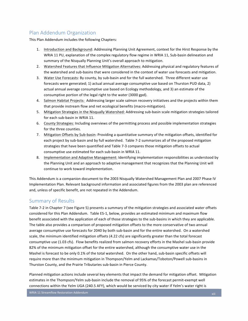
Plan Addendum Organization ThisPlanAddendumincludesthefollowingChapters:
1. IntroductionandBackground:AddressingPlanningUnitAgreement,contextfortheHirstResponsebythe
WRIA11PU,explanationofthecomplexregulatoryflowregimeinWRIA11,Sub-basindelineationand
summaryoftheNisquallyPlanningUnit’soverallapproachtomitigation.
2. WatershedFeaturesthatInfluenceMitigationAlternatives:Addressingphysicalandregulatoryfeaturesof
thewatershedandsub-basinsthatwereconsideredinthecontextofwateruseforecastsandmitigation.
3. WaterUseForecasts:Bycounty,bysub-basinandforthefullwatershed.Threedifferentwateruse
forecastsweregenerated;1)actualannualaverageconsumptiveusebasedonThurstonPUDdata,2)
actualannualaverageconsumptiveusebasedonEcologymethodology,and3)anestimateofthe
consumptiveportionofthelegalrighttothewater(3000gpd).
4. SalmonHabitatProjects:Addressinglargerscalesalmonrecoveryinitiativesandtheprojectswithinthem
thatprovideinstreamflowandnetecologicalbenefits(macro-mitigation).
5. MitigationStrategiesintheNisquallyWatershed:Addressingsub-basinscalemitigationstrategiestailored
foreachsub-basininWRIA11.
6. CountyStrategies:Includingoverviewsofthepermittingprocessandpossibleimplementationstrategies
forthethreecounties.
7. MitigationOffsetsbySub-basin:Providingaquantitativesummaryofthemitigationoffsets,identifiedfor
eachprojectbysub-basinandbyfullwatershed.Table7-2summarizesalloftheproposedmitigation
strategiesthathavebeenquantifiedandTable7-3comparesthosemitigationoffsetstoactual
consumptiveuseestimatedforeachsub-basininWRIA11.
8. ImplementationandAdaptiveManagement:Identifyingimplementationresponsibilitiesasunderstoodby
thePlanningUnitandanapproachtoadaptivemanagementthatrecognizesthatthePlanningUnitwill
continuetoworktowardimplementation.
ThisAddendumisacompaniondocumenttothe2003NisquallyWatershedManagementPlanand2007PhaseIV
ImplementationPlan.Relevantbackgroundinformationandassociatedfiguresfromthe2003planarereferenced
and,unlessofspecificbenefit,arenotrepeatedintheAddendum.
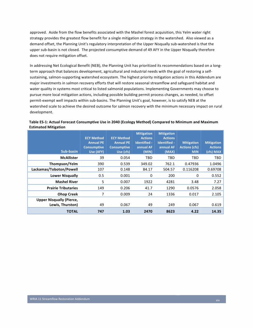
Summary of Results Table7-2inChapter7(seeFigure5)presentsasummaryofthemitigationstrategiesandassociatedwateroffsets
consideredforthisPlanAddendum.TableES-1,below,providesanestimatedminimumandmaximumflow
benefitassociatedwiththeapplicationofeachofthosestrategiestothesub-basinsinwhichtheyareapplicable.
Thetablealsoprovidesacomparisonofproposedmitigationoffsetstothemoreconservativeoftwoannual
averageconsumptiveuseforecastsfor2040bybothsub-basinandfortheentirewatershed.Onawatershed
scale,theminimumidentifiedmitigationoffsets(4.22cfs)aresignificantlygreaterthanthetotalforecast
consumptiveuse(1.03cfs).FlowbenefitsrealizedfromsalmonrecoveryeffortsintheMashelsub-basinprovide
82%oftheminimummitigationoffsetfortheentirewatershed,althoughtheconsumptivewateruseinthe
Mashelisforecasttobeonly0.1%ofthetotalwatershed.Ontheotherhand,sub-basinspecificoffsetswill
requiremorethantheminimummitigationinThompson/YelmandLackamas/Toboton/Powellsub-basinsin
ThurstonCounty,andthePrairieTributariessub-basininPierceCounty.
Plannedmitigationactionsincludeseveralkeyelementsthatimpactthedemandformitigationoffset.Mitigation
estimatesintheThompson/Yelmsub-basinincludetheremovalof95%oftheforecastpermit-exemptwell
connectionswithintheYelmUGA(240.5AFY),whichwouldbeservicedbycitywaterifYelm’swaterrightis
WRIA11StreamflowRestorationAddendum
xiv
approved.AsidefromtheflowbenefitsassociatedwiththeMashelforestacquisition,thisYelmwaterright
strategyprovidesthegreatestflowbenefitforasinglemitigationstrategyinthewatershed.Alsoviewedasa
demandoffset,thePlanningUnit’sregulatoryinterpretationoftheUpperNisquallysub-watershedisthatthe
uppersub-basinisnotclosed.Theprojectedconsumptivedemandof49AFYintheUpperNisquallytherefore
doesnotrequiremitigationoffset.
InaddressingNetEcologicalBenefit(NEB),thePlanningUnithasprioritizeditsrecommendationsbasedonalong-
termapproachthatbalancesdevelopment,agriculturalandindustrialneedswiththegoalofrestoringaself-
sustaining,salmon-supportingwatershedecosystem.ThehighestprioritymitigationactionsinthisAddendumare
majorinvestmentsinsalmonrecoveryeffortsthatwillrestoreseasonalstreamflowandsafeguardhabitatand
waterqualityinsystemsmostcriticaltolistedsalmonidpopulations.ImplementingGovernmentsmaychooseto
pursuemorelocalmitigationactions,includingpossiblebuildingpermitprocesschanges,asneeded,tooffset
permit-exemptwellimpactswithinsub-basins.ThePlanningUnit’sgoal,however,istosatisfyNEBatthe
watershedscaletoachievethedesiredoutcomeforsalmonrecoverywiththeminimumnecessaryimpactonrural
development.
TableES-1:ActualForecastConsumptiveUsein2040(EcologyMethod)ComparedtoMinimumandMaximumEstimatedMitigation
Sub-basin
ECYMethodAnnualPE
ConsumptiveUse(AFY)
ECYMethodAnnualPE
ConsumptiveUse(cfs)
MitigationActions
Identified-annualAF
(MIN)
MitigationActions
Identified-annualAF
(MAX)
MitigationActions(cfs)
MIN
MitigationActions
(cfs)MAX
McAllister 39 0.054 TBD TBD TBD TBD
Thompson/Yelm 390 0.539 349.02 762.1 0.47936 1.0496Lackamas/Toboton/Powell 107 0.148 84.17 504.57 0.116208 0.69708
LowerNisqually 0.5 0.001 0 200 0 0.552
MashelRiver 5 0.007 1922 4281 3.48 7.27
PrairieTributaries 149 0.206 41.7 1290 0.0576 2.058
OhopCreek 7 0.009 24 1336 0.017 2.105UpperNisqually(Pierce,
Lewis,Thurston) 49 0.067 49 249 0.067 0.619
TOTAL 747 1.03 2470 8623 4.22 14.35
WRIA11StreamflowRestorationAddendum
1-1
Chapter 1 Introduction and Background
1.1 Nisqually Watershed Planning and the Hirst Response TheNisquallyWatershedPlanningUnitcontinuestoworkcollaborativelytoaddresswaterresourceissueswithin
theNisquallyWatershed(WaterResourceInventoryArea[WRIA]11).Actingunderauthorityofthe1998
WatershedManagementAct(chapter90.82RCW),withtheNisquallyIndianTribeastheLeadAgency,the
NisquallyPlanningUnitadoptedinOctober2003theNisquallyWatershedManagementPlan(Golder,2003).
ActingatajointmeetingheldApril13,2004,Lewis,PierceandThurstoncountiesunanimouslyapprovedthatplan.
Continuingitscollaborativework,theNisquallyPlanningUnitinFebruary2007adoptedthePhaseIVNisqually
ImplementationPlan(Golder,2007),furtheridentifyingactionstobetakentoimplementthe2003Plan.
InJanuary2018,theWashingtonStateLegislatureadoptedEngrossedSubstituteSenateBill6091(latercodifiedas
chapter90.94RCW,theStreamflowRestorationAct)toaddressa2016WashingtonSupremeCourtdecision
(WhatcomCountyvs.WesternWashingtonGrowthManagementHearingsBoard;commonlyreferredtoasthe
“HirstDecision”).TheHirstDecisionrequiredcountiestoindependentlyverify,whenissuingabuildingpermit,that
impactsfromproposednewdomesticpermit-exemptwellsrequiredfordevelopmentapplicationswouldnot
impairseniorwaterrights,includingestablishedminimuminstreamflows.TheLegislatureadoptedchapter90.94
RCWtoprovideclaritytocountiesandapathforwardforallowingruraldomesticdevelopmentthatrelieson
permit-exemptwellconnectionsforawatersource.
TheStreamflowRestorationActdirectstheWashingtonStateDepartmentofEcology(Ecology)toworkwith
InitiatingGovernmentsandPlanningUnitstoidentifypotentialimpactsofpermit-exemptwelluse,identify
evidence-basedconservationmeasuresandidentifyprojectsandactionstoimprovewatershedhealthandoffset
potentialimpactstoinstreamflowsassociatedwithpermit-exemptdomesticwateruse.Thelawalsorequiresthat
eachcountyinWRIA11recordrestrictionsorlimitationsassociatedwithwatersupplywiththepropertytitle,
collectafeeof$500fromeachbuildingpermitapplicant($350ofwhichistransmittedtoEcology),recordthe
numberofbuildingpermitsandtransmitanaccountofbuildingpermitsandsubdivisionapprovalssubjecttothe
lawannually,andlimitthewithdrawalexemptionforanapplicanttoamaximumannualaverageof3000
gpd/connection.
1.2 Scope of this Addendum and Agreements TheStreamflowRestorationAct(theAct)mandatedthattheNisquallyPlanningUnit,actingunderauthorityof
RCW90.82,updatetheNisquallyWatershedManagementPlantoexplicitlyaddressfuturepermit-exempt
domesticgroundwaterwithdrawalsoverthenext20years,thepotentialimpactsofthoseforecastedwithdrawals
onminimumstreamflowsandotherseniorwaterrights,andstrategiestomitigateforthoseimpacts.The
mandateddeadlineforthisactivityisFebruary1,2019.TheNisquallyPlanningUnitreconvenedinJulyof2018,
andundertheleadershipoftheNisquallyIndianTribe,craftedaformalWorkingAgreementunderwhichto
operatewhileaddressingtherequirementsoftheAct.TheWorkingAgreement,includedasAppendixA,describes
thedecisionframeworkforapprovalofthisWatershedPlanAddendumbythePlanningUnit.
WhilemostwatershedssubjecttotherequirementsoftheRCW90.94haveovertwoyearstorespondtothe
requirementsoftheAct,theNisquallyWatershedPlanningUnithadlessthanoneyear.Therearethreecounties
locatedwithinthewatershed,allofwhichmayconsiderimplementingchangestotheircurrentbuilding
WRIA11StreamflowRestorationAddendum
1-2
applicationprocesstoaddressruralwateruse.Duetotheshorttimeframe,somemitigationstrategiesthatare
beingdevelopedtooffsetpotentialstreamflowimpactsfrompermit-exemptwellwithdrawalsneedfurther
developmentandquantificationafterthemandatedFebruary1,2019planupdate.
Thurston,PierceandLewisCountiesarelayingthegroundworkformitigationstrategiesthatmaybeappliedand
furtherdevelopedforotherwatershedsintheirresponsestochapter90.94RCW.ThurstonCountyisinvolvedin
StreamflowRestorationActprocessesinWRIAs13,14,22and23;PierceCountyinWRIAs10,12and15;andLewis
CountyinWRIAs13and23.ThePlanningUnithasstructuredanadaptivemanagementapproachthatwillcontinue
afterFebruary1,2019toenableImplementingGovernmentstofullydevelopmitigationactionsandimplement
potentialcodeorordinancechangestoenableoffsetsifneeded.Detailedevaluationofhabitatprojectsand
technologiesthatwillmorespecificallyquantifystreamflowbenefitswillalsooccurduringthisadaptive
managementperiod.Chapter8addressesthePlanningUnit’sadaptivemanagementapproach.
ThePlanningUnitrecognizesthattheprocesssetupbythelegislationandthestrategiesoftheplanaddressonlya
smallportionofwateruseinthewatershed;thatattributedtofuturedomesticpermit-exemptwells.Theplan
doesnotaddresshistoricimpacts,nordoesitattempttoquantifyoraddresspotentiallylargerimpactsto
streamflowsfromfactorssuchasnon-domesticuses,climatechange,andchangestolandcover.Adaptive
managementisanimportantprincipleinensuringthatmanagingfortheimpactsofpermit-exemptwellstakes
placeinthecontextoflargerwateruseandenvironmentalissuesinthewatershed.
ThisdocumentservesasanAddendumtothe2003PhaseIIINisquallyWatershedManagementPlan(Golder,
2003)andthe2007PhaseIVNisquallyImplementationPlan(Golder,2007)andisnarrowlyfocusedspecificallyto
addresstherequirementsoftheStreamflowRestorationAct.TheActrequirestheNisquallyWatershedPlanning
Unittoprepareaplanupdatethatprovidesmitigationfortheprojectedimpactsofdomesticuseofnewpermit-
exemptwellsoninstreamflowsoccurringbetween2018and2040.ThisAddendumprovidesforecastsof
consumptivewaterusefromdomesticpermit-exemptgroundwaterconnectionsinthewatershedand
recommendsactionstooffsetthoseimpacts.Theactionshavebeendevelopedsuchthattheyprovideanet
ecologicalbenefit(NEB)toinstreamresourceswithintheentireNisquallyWatershed(WRIA11).
ThisAddendumisconsideredacompaniondocumenttothe2003NisquallyWatershedManagementPlanand
2007PhaseIVImplementationPlan.Relevantbackgroundinformationandassociatedfiguresfromthe2003plan
arereferencedand,unlessofspecificbenefit,arenotrepeatedherein.
TheoriginalNisquallyWatershedPlanningUnitdefinedfivekeychallengesintheir2003WatershedManagement
Plan(Golder,2003).Threeofthosechallengesdirectlyaddressthenexusbetweengrowthmanagementandrural
watersupply.The2007NisquallyImplementationPlanprovidedfourrecommendationstotheDepartmentof
Ecologytoaddresspermit-exemptwelluseandtheconsumptiveimpactsofthatuseonlocalinstreamresources
(Golder,2007,p.15).Theseincluded:
GW-7(EW) ThisplanrecommendsthatEcologyprovidemorethoroughoversightofexemptwells(seeWAC173-
511-070).Theissuanceofastartcard(noticeofintenttodrill)foranexemptwellbywelldrillersand
Ecology’sdatabaseofstartcardsshouldbeconsistentwithavailableinformationonCoordinated
WaterSystemPlanserviceareaboundaries,availablehydrogeologicinformationonlocalaquifers,
andcumulativeeffectsofexemptwells.
GW-7a(EW) TheDepartmentofEcologyshouldstudythecumulativeimpactsofexemptwellsandconsider
settingabasin-widestandardforthenumberofhousesallowableperexemptwell.Thisplan

WRIA11StreamflowRestorationAddendum
1-3
recommendsthatEcologyincreasetheirenforcementoftheexemptwellstatute1anddevelopan
ExemptWellActionPlantoachievecompliancewiththeintentoftheexemptwellwithdrawal
statute.(Seepage43inthePlanfordetails.)ThePlanningUnitwillidentifyareasfor
characterizationinthisstudyasa2006worktask.
GW-7b(EW)OncesufficientinformationisgatheredonthecumulativeimpactsofexemptwellsasdirectedinGW-7a(EW), thePlanningUnitmaywishtoconsideravenuestoaddressthedrillingofexemptwells inareas where technical data indicate theymay have impact on surface water systems. In sensitiveareas,thismightincludetheoptionofdrillingindeeperaquifersthataremoreprotectiveofsurfacewater,ifavailable.
GW-8(EW) Developapolicytotransferexemptwellwaterrightswithinawaterserviceareaorurbangrowth
areatoawaterpurveyorandsubmittoEcologyforwaterrightcredit.Definehowmuchcreditshould
begrantedfortakingexemptwellsofflineaspartofthispolicy.
Thefourrecommendations(above)madebytheNisquallyPlanningUnitintheirWatershedImplementationPlan
recognizedtheneedtoaccountfortheimpactsofpermit-exemptgroundwaterusesonstreamflow,particularlyin
sub-basinswithadoptedinstreamflowrules.However,implementationofthoserecommendationswasdirected
totheDepartmentofEcology(Ecology).TheHirstdecisionandsubsequentlegislationinterpretstheGrowth
ManagementAct(GMA)asrequiringthatthecountiesexercisetheirownindependentstatutoryresponsibilityto
makeadeterminationaboutthephysicalavailabilityandlegalavailabilityofwater.Itisthecounties’dutyunder
GMAtoprotectwateravailability,particularlyinwater-shortareas.Thisincludesensuringthatthecumulative
impactsofoneormorenewpermit-exemptwellsdonotimpairminimuminstreamflowsorotherseniorwater
rights.
1.3 Sub-Basin Delineation ConsistentwithEcologyguidancefordevelopingwateruseestimatestodelineatetheWRIAinto“suitablysized
[areas]toallowmeaningfuldeterminations”(Ecology,2018a),WRIA11wasdividedintoeightareasreferredtoas
aggregatedsub-basins.Theaggregatedsub-basinsarebasedonpreviouswatershedplanningdelineations,an
understandingofdifferinghydrogeologicregimes,andpoliticalboundariesthatdelineatespecificcounties.
Watershedhydrogeologyisdescribedbysub-watershedinSection4.2ofthe2003WatershedPlan(Golder,2003).
Abriefsummaryofphysicalsub-basincharacteristicsrelatedtomitigationstrategiesisprovidedforeachsub-basin
inChapter2ofthisAddendum.Theaggregatedsub-basinsarelistedinTable1-1andshownonFigure1.
Table1-1:WRIA11AggregatedSub-BasinsAggregatedSub-Basin County
McAllister ThurstonThompson/Yelm Thurston
Lackamas/Toboton/Powell ThurstonLowerNisqually PierceMashelRiver Pierce
PrairieTributaries PierceOhopCreek Pierce
UpperNisqually(Lewis,Pierce,Thurston) PortionsofLewis,PierceandThurston
12007Ecologycommentsstatedthattheyhaveselectivelyenforcedthepermit-exemptwelllawsasresourceshavepermitted.
WRIA11StreamflowRestorationAddendum
1-4
1.4 Established Instream Flows in WRIA 11 MinimuminstreamflowregulationshavebeenestablishedinWRIA11byEcologyundertheInstreamResource
ProtectionProgram(IRPP)andaredescribedinChapter173-511oftheWashingtonAdministrativeCode(WAC).
InstreamFlowsandclosuresintheNisquallyWatershedhaveaprioritydateofFebruary1981,whentheywere
adoptedasadministrativerule.WAC173-511wasthenrevisedin1988.Thefulltextoftheadministrativecodeis
includedasAppendixB.WaterbodiesaffectedbyinstreamflowregulationsareshownonFigure2.
FlowregulationsinWRIA11consistofminimuminstreamflowlevelsandsub-basinclosurestofurther
consumptiveuse.InWAC173-511,instreamflowlevelsweresetforfoursegmentsoftheNisquallyRiver,each
withaspecificflowcontrolormeasuringsite(aboveAlderreservoir,belowtheLaGrandePowerhouse,thebypass
reachandbelowtheCentraliaPowerhouse)andfortheMashelRiver,measuredattheUSGSgaugeontheMashel
River(Figure2).Additionalminimuminstreamflowrequirementsareinplaceyear-roundforthebypassreach,the
reachbelowLaGrandePowerhouse,andthereachbelowtheLaGrandeDam,establishedbytheFederalEnergy
RegulatoryCommission(FERC)aslicenserequirementsfortheTacomaPublicUtilitiesNisquallyHydroelectric
ProjectandtheCityofCentralia’sYelmHydroelectricProject.
Inadditiontotheseminimumflows,20tributariesandlakesandtwosegmentsoftheNisquallymainstemhave
beenclosed,atleastseasonally,tofurtherallocation.TheclosuresareshownonFigure2.Somestreamclosures
identifiedintheIRPPwereestablishedbyearlieradministrativeactionsdatingbackasfaras1944.Theseclosures
alsohaveaprioritydateof1981,whentheywere“re-adopted”asadministrativerule.Sincetheseolderclosures
donotspecifyaperiodofclosure,itisassumedthattheclosureisappliedyear-round.
Theseinstreamflowrulesprovideawaterrightforeachsubjectstreamorriversegmentwithanassociateddate
thatisseniortoanypermit-exemptwelluseinitiatedsubsequenttothatdate.MuchoftheNisquallyWatershedis
administrativelyclosedtonewwaterappropriationduetotheestablishmentofinstreamflowsunderWAC173-
511-030andclosuresestablishedunderWAC173-511-040.Waterbodiesimpactedbytheserulesareshownin
Figure2.TheNisquallyRiversegmentaboveTacoma’shydroelectricprojectandtributariestothatsegment(the
UpperNisquallysub-basinofthisplan)werenotclosedtofurtherappropriationbytheIRPP.
Althoughthe2003NisquallyWatershedPlanrecognizedtheimpactsofpermit-exemptwelluseonlocal
streamflowandrecommendedthatactionsbetakenbyEcologytoaddressthoseimpacts,thePlandidnotcreatea
waterreservationforruralgrowthtoaddresstheminimumstreamflowsandclosurespreviouslyadoptedunder
Chapter173-511WACforthewatershed.HenceWRIA11issubjecttotherequirementsofthe2018Streamflow
RestorationAct(Chapter90.94RCW)andmustaddresspotentialimpairmenttoaninstreamflowfromfuture
domesticpermit-exemptwelluse.
1.5 Nisqually Approach to Mitigation TheNisquallyPlanningUnitistakingatwo-partapproachtomitigatingtheimpactsoffutureruralgrowthon
streamflowsinthewatershed.Sub-basinspecificoffsetsor“micro-mitigation”willtaketheformofprojects
involvingaquiferrecharge,useofdeeperaquiferstominimizeimpactstolocalsurfacewaterbodiesandwater
rightacquisition,andpoliciesthatreduceruralwateruseandtrackmitigationcreditsaspartofCountybuilding
permitapproval.Thesesub-basinspecificmicro-mitigationstrategiesareintendedtorestorestreamflows
impactedbypermit-exemptgroundwaterusewithinsub-basinsoverthenext20years.Micro-mitigationactions
can,inmostcases,beimplementedasspecificoffsetswithinsub-basins,viaamitigationcreditbankorother
accountingsystemavailabletonewdevelopmentapplicants.Somesub-basin-specificoffsetsarealsogeneratedby

WRIA11StreamflowRestorationAddendum
1-5
localhabitatprojects.Theseprojectsarestrategicallylinkedtolarge-scalehabitatinitiativesaddressingNet
EcologicalBenefitforthewatershed,butthestreamflowbenefitstheyprovideareappliedatasub-basinscale.
Larger,watershed-scalehabitatprojectsthatprovideaNetEcologicalBenefit(NEB)fortheentirewatershedarereferredtoas“macro-mitigation”andprovidebothflowbenefitsandecologicalbenefitsessentialtonativesalmonpopulations.ThePlanningUnitviewsthesewatershed-scalemacro-mitigationgoalsasessentialtothebroadergoalsoftheStreamflowRestorationActtoprotectinstreamflowsandsalmonpopulationsinaneraofincreasingdevelopmentandchangingclimate.Withdrawalsfromdomesticpermit-exemptwellsareonerelativelysmallcomponentofthewaterusechallengesfacingtheNisquallyWatershedinthecomingdecades.Asclimatechangeimpactsprecipitationandhydrologicpatterns,meetingthewaterneedsofthegrowingcommunitiesofthemiddleandlowerwatershedbasinswilldependonlong-termconservationactionstakenthroughoutthewatershed.ThisAddendumdiscussesmacro-mitigationstreamflowactionsinthecontextofmajorsalmonrecoveryhabitatinitiativesandprovidingsustainableNEBthatsupportsthiscentralgoaloftheNisquallyWatershedcommunity.
Macro-mitigationprojectsandtheNEBtheyprovideatawatershedscalearediscussedinthecontextofSalmon
RecoveryinChapter4.Micro-mitigationprojectsandpoliciesandthemitigationtheyprovidetooffsetthedirect
impactofpermit-exemptwellsonlocalstreamflowatasub-basinscalearediscussedinChapters5and6.
1.6 Funding for Mitigation WhiletheNisquallyPlanningUnit’slegislatively-directedaggressivetimeframedidnotallowdevelopmentofadetailedfundingstrategy,thePlanningUnitnotesthattheintentisforstrategiesinthisplantobefundedinlargepartbystatefundingmechanisms,includingfundingprovidedundertheStreamflowRestorationAct.Thisisparticularlytrueforthemacro-mitigationstrategies.Countypermittingmitigationfeesmaybeapartialsourceoffundingforbothmacroandmicrostrategiesinthefuture;however,thePlanningUnitwishestomakeclearthatapplicablefeesdirectedbytheStreamflowRestorationActintheirpresentformcannotandshouldinnowaybeexpectedtofinanciallysupporttheambitiousrecoveryapproachsetoutinthisplan.

WRIA11StreamflowRestorationAddendum
2-6
Chapter 2 Watershed Features that Influence
Mitigation Alternatives
2.1 Watershed Overview in the Context of Mitigation TheNisquallyWatershedPlanningUnithasdividedthewatershedintoeightsub-basinsinwhichtoaddresssub-
basinspecificmitigationstrategies(Figure1).ThegoalofthisplanAddendumistoidentifythelikelyimpactsof
newpermit-exemptwellconnectionsonstreamflowsineachsub-basinoverthenext20years,andtoidentify
actionsthatwillmitigatethoseimpacts.Mitigationoptionsarenot“onesizefitsall”withintheWRIA.The
hydrologiccharacteranddevelopmenttrendsineachsub-basinspeaktothetypeofmitigationthatwillmost
appropriatelyprovideinstreamflowbenefitstooffsetimpactsfromforecastdomesticpermit-exemptwell
withdrawals,aswellasnon-streamflownetecologicalbenefitstosalmon.
Thischapterdescribesthephysicalcharacteristicsofthewatershedandspecificsub-basinsinthecontextof
appropriatemitigationalternatives.Eachsub-basindiscussionincludesthecurrentstateofknowledgeaboutthe
sub-basinincludingbasichydrogeology,streamandaquiferflows,salmonusage,historiclandusetrendsandthe
regulatoryinstreamflowstatus.
2.2 Watershed Hydrology and Geology ThegeologyandstreamflowsofvariousNisquallysub-basinshavebeendescribedindetailinthe2003Watershed
Planandnumerousotherstudies(Golder,2003;Pringle,2008).Thissectionprovidesageneralsummaryofthe
watershed’shydrogeologyasbackgroundtoidentifyingviablestrategiestomitigatethestreamflowimpactsof
newpermit-exemptwellsfordomesticuse.Chapter4.2ofthe2003WatershedPlanprovidesin-depthbackground
andreferencesforspecificsub-basingeology,hydrogeology,andhydrologiccontinuity.Figure8ofthe2003
WatershedPlan(includedasFigure3inthisAddendum)providesahydrogeologiccrosssectionshowingthe
alternatinggeologicunitsthatcreatethemultipleaquifersandaquitardsunderlyingthewatershed.Theunderlying
geologyofasub-basininfluencestoalargeextentthemovementandavailabilityofgroundwaterinthearea.It
alsohasalargeinfluenceonthehydrauliccontinuitybetweenstreamsandgroundwater,andhence,betweenwell
withdrawalsandgroundwater.BecausethisAddendumisacompaniondocumenttothe2003Plan,thissection
summarizesthismaterialbrieflyasneededtoaddresstheimpactsofpermit-exemptwellwateruse.
TheNisquallyWatershedhastwoprimarybroadgeologicalstructuresand,asaresult,twotypesofstreams.The
first,locatedintheOhop,MashelandUpperNisquallysub-basinsintheupperpartofWRIA11,consistsofhills,
lowmountainsandMountRainierunderlainprimarilybybedrock.Inmostyearseventhelowerelevationsofthese
uplandsreceivesnow,withsignificantsnowaccumulationsinupperelevations.Streamsintheupperwatershed
canflowwithhighvolumeandvelocity,especiallyfollowingrainonsnowevents.
Thereisatotalblockagetosalmonmigrationatapproximatelyrivermile40oftheNisquallyRiveratAlderDam.
Thus,thePlanningUnithasdividedthiseasternareaintotheUpperNisqually(theareaabovesalmonaccess)and
twosub-basinswithsalmonaccessandupperelevationgeology–theMashelandOhopsub-basins.Regardlessof
location,theprimarylanduseintheeasternareaofthewatershediscommercialtimber,withalmostallofthe
landbeingforested.VirtuallyallofthisareaisinPierceandLewiscounties.
ThesecondbroadgeologicalareaiswestoftheEatonville/Route161lineandincludesalmostalloftheThurston
CountyportionofthewatershedandpartsofPierceCounty.Thisistheareaofthecountythatwasimpactedby

WRIA11StreamflowRestorationAddendum
2-7
theContinentalglaciers,commencingover100,000yearsagountilthemostrecentVashonStageoftheFraser
Glaciationbeganapproximately15,000yearsago.Astheglaciersadvancedandthenretreated,manytimesover
thousandsofyears,theyleftgeologicallayersofalternatingoutwashsandandgravel,andlayersofthickglacialtill
andotherlow-hydraulicconductivity.Thesandandgravellayerscontainwaterandtheselayersaregenerally
referredtoasaquifers.Theglacialtilllayerswhollyorpartiallyconfineportionsoftheaquifers.However,thereis
typicallysomedegreepfhydraulicconnection(continuity)betweentheaquifers.Thesedepositsdifferdramatically
incompositionandthicknessineachofthesub-basins,resultinginsomeareaswithprolificsuppliesof
groundwaterwhileothershaveminimalsupply.TheUSGSandothershaveconductedextensivestudies
characterizingthehydrogeologyofsouthernPierceCountyandNorthwestThurstonCounty(Jonesetal,1999;
Dionetal,1994;Drostetal,1999;CDM,2001;CDM,2002).ThesestudiesaresummarizedintheNisqually
ManagementWatershedPlan(Golder,2003;seeSection4.2).
Withintheseareasinthewesternpartofthewatershed,rainfallpercolatesintothegroundveryrapidly.
Therefore,streamsinthisareaaresmallrelativetothesizeofthedrainageareaandmanystreamsare
intermittentinthattheyonlyflowatsometimesduringtheyear.Beforebeingotherwisedeveloped,theseareas
werevastprairieswithsignificanttreegrowthfoundonlyinwetlandareasandalongstreamcorridors.
Mostofthestreamsinthewesternpartofthewatershed,characterizedbyruralresidentialdevelopment
(includingLackamas/Toboton/Powell,Yelm/ThompsonandPrairieTributariessub-basins),areintermittent
streams–streamsthatareinclosecontactwiththeupper,ornear-surface,aquifer.Thesestreamsloseflowasthe
aquiferwaterlevelsdiminishindrymonthsandgainflowastheaquiferisrechargedwiththefallandwinterrains.
Section4.2.1ofthe2003WatershedPlandescribessub-basingroundwateravailabilityindetail.Becauseofthis
intermittentflowpattern,thesestreamsexhibitlowflowsthatareexpectedtobeexacerbatedbynewpermit-
exemptwellsintheshallow,orsurface,aquifer.Therefore,thisplanAddendumincludesafocuseddiscussionof
mitigationoptionsfortheseprairiestreams(seeChapter5).
Itisimportanttonotethatmajorstreamflowchangesoccurbecauseofbothseasonaleffectsanddiversionsor
withdrawalsofsurface/groundwater.InWRIA11inThurstonCountyalone,atleast3,655wellsarecurrently
pumping,withacombinedestimatedactualgroundwaterwithdrawalof17,502AFY.Existingwells’effectsarenot
consideredinthisplanAddendumbecausetheyarenotpartofStreamflowRestorationActrequirements.Existing
diversionsandwithdrawals,however,formthecontextforprioreffectsonstreamflow.
2.3 Sub-Basin Characteristics Thefollowingsectionsprovidebackgroundonphysicalandregulatorycharacteristicsofeachsub-basininthe
Nisquallywatershed.
2.3.1 McAllister Sub-Basin – Thurston County ThemajorpartoftheMcAllisterSub-Basin,locatedinThurstonCounty,consistsprimarilyofthelowerNisqually
Valley,downstreamoftheNisquallyIndianReservation.OtherthantheNisquallyRiveritself,themajorstreamin
theareaisMcAllisterCreek,anindependentstreamthatdischargesdirectlyintotheNisquallyEstuary.Thissub-
basinalsoincludestheLakeSaintClairwatershed,asmallindependentwatershedofonestream,EatonCreek,
whichdischargesintothelake.Thelakeitselfdischargestotheaquifer.
Geology
TheunderlyinggeologyoftheMcAllisterSub-Basinisentirelyglacialandpost-glacial.ThebroadlowerNisqually
Valley,carvedbythecontinentalglacier,consistsofriverinesandandsedimentdepositedoverthepast10,000
WRIA11StreamflowRestorationAddendum
2-8
yearsbytheNisquallyRiver.Thebluffssurroundingthevalleyconsistofsand,gravelandclaydepositsleftbythe
glacierasitretreated.Astheyretreated,theglaciersleftextensiveoutwashareasofsandandgravel,somenear
thesurfaceandothersburiedmoredeeply.Theglacieralsodepositedthicklayersofsedimentthat,when
compressed,becomehardclay(glacialtill).
Water
Themajorstreamofthissub-basinistheNisquallyRiver,whichdrainsthe786-squaremilewatershedandbrings
abundantsedimenttothelowerNisquallyValley.Therearetwoindependentstreams,McAllisterandEaton
creeks,thatderiveflowfromspringsdischargingfromaquifersasthestreamcourseandaquiferintersect.
Mostoftherainfalllandinginthissub-basindischargesnotassurfaceflowinstreamsbutrathertoPugetSound
throughtheseveraldeeperaquifersunderlyingthesub-basin.Asignificantquantityofgroundwaterflowinthe
Qva(Vashonadvanceoutwash)andQc(pre-Vashonglacialunit)aquifersappeartoconvergetoward
McAllister/AbbotSpringsandMcAllisterCreekinthenorthernportionoftheMcAllistersub-basin.The2003
WatershedPlandescribesthishighlyproductiveaquiferasthe“NisquallyAquifer”.Becausetheseaquifersare
importantregionalsourcesofdrinkingwater,theyhavebeenstudiedextensively(Dionetal,1994;Drostetal,
1999;CityofOlympiaandNisquallyIndianTribe,2008).Allthesestudiesindicatethatthereareseveralaquifer
layers,usuallyatleastthree:theshallowQva,andintermediateanddeepaquifers;theQcaquiferandtheTQu
depositsthatareconsideredundifferentiateddepositsunderlyingtheunderlyingtheQc.Inthissub-basin,theQc
aquiferandTQuareconsideredpartofthe“NisquallyAquifer”andarebelowsealevelanddischargeprimarilyto
PugetSound.
SalmonUsage
TheNisquallyRiveristhemajormigrationcorridorforallsalmonspeciesenteringorleavingtheNisqually
Watershed.McAllisterCreekanditstributaries,asanindependentdrainage,receivesomesalmonspawningof
variousspecieseveryyear.However,thesespawningrunsarerelativelyminorandarenotmanagedseparately.
EatonCreekhasnoconnectionwithPugetSound.
LandUseandDevelopment
TheMcAllistersub-basinhasthemostvariedlanduseinthewatershed,includinghighlyurbanizedareas,rural
areas,andlargeopenspaceandrecreation.Thewesternportionofthesub-basinlieswithintheLaceyUrban
GrowthArea(UGA)ortheincorporatedCityofLacey.DevelopmentintheLaceyUGA,whichincludesmoderate-
densityresidentialuseandtheMartinWayCorridor,willlikelydependontheCityofLaceyformunicipalwater
service.Newlow-densityruralresidentialdevelopmentthatusespermit-exemptwellsasawatersourceismost
likelytobedevelopedinareaszonedasRuralResidential1/5orRuralResidentialResource1/5.However,manyof
theseareasmayalsobewithintheboundaryofoneofthe21existingGroupBpublicwatersystemsinthesub-
basin(personalcommunication,ThurstonPUD).
Onefifthofthesub-basiniszonedasMcAllisterGeologicSensitiveArea(MGSA),alow-impactzoningdesignation
createdtoprotecttheCityofOlympia’swatersource,whichhasrestrictivedevelopmentregulations.
Approximately1,000acresiszonedforlong-termagriculture;manyoftheavailabledevelopmentrightsassociated
withparcelsintheNisquallyAgriculturezoningdistrictwerepurchasedandretiredinthelate1990s,andthuswill
notexperiencefurtherdevelopment.Thesouthernportionofthesub-basinfallswithinJointBaseLewis-McChord
andiszonedasaMilitaryReservation–noadditionalresidentialdevelopmentisanticipatedinthisarea.Because
oftheextensiveglacial-origindeposits,thereareandlikelywillcontinuetoberelativelylargesandandgravel
miningoperationsinthissub-basin.
WRIA11StreamflowRestorationAddendum
2-9
RegulatoryHistory
TheNisquallyRiverinthissub-basinhasaminimumflowrequirementbutisnotclosedforfutureout-of-stream
waterappropriations(seetheInstreamResourcesProtectionProgram[IRPP]fortheNisquallyWatershed,adopted
in1981,Chapter173-511WAC)(AppendixB).Therefore,becauseoftheirveryminorflowimpacts,newdomestic
permit-exemptwellsadjacenttotheNisquallyRivercanlikelybepermittedwithoutexplicitmitigationoffsets.
Becauseofthesubstantialout-of-streamirrigationinthevalley,astreamclosureofEatonCreekbyadministrative
actionwasputinplacein1953.ThisclosurewasconfirmedbytheIRPPin1981.Neitherthe1952closurenorthe
IRPPplacedanyexplicitrestrictionsonfuturegroundwaterwithdrawals.LakeSaintClairwasalsoclosedtofuture
waterappropriationsbythis1981program.ForMcAllisterCreek,the1981IRPPclosesthestreamtoout-of-stream
waterallocations.
2.3.2 Thompson/Yelm Sub-Basin – Thurston County TheThompson/Yelmsub-basin,locatedinThurstonCounty,includestheCityofYelmanditsUGA,andsurrounding
ruralareas.Therearetwoindependentstreamsinthissub-basinbuttheyaremergedintoonesub-basinbecause
oftheirunitywithinthegeneralYelmareaandtherelativelyhighgrowthratetheyhaveexperiencedinrecent
years.
Geology
Understandingthegeologyandgeologicalhistoryofthissub-basinisessentialtounderstandingandaddressingits
streamflowpatterns,possibleimpactsofpermit-exemptwellsandpossibleapproachestomitigatingthose
impacts.Overthepast100,000yearsthispartofThurstonCountywassubjecttomultipleglacialadvancesand
retreats,themostrecentofwhichendedalittleover10,000yearsago.Astheyadvancedandthenretreated,the
glaciersleftextensiveoutwashareasofsandandgravel,somenearthesurfaceandothersburiedmoredeeply.
Theglacieralsodepositedthicklayersofsedimentthat,whencompressed,becomeglacialtillor“hardpan”.Thus,
wehavesurficialandburiedlayersofsandandgravelthatholdwater(theselayersaretermed“aquifers”)and
glacialtilllayersthathinderconnectionsbetweentheaquiferlayers(theselayersarecalled“aquitards”).
Water
Thestreamsinthissub-basin(withtheexceptionoftheNisquallyRiveritself)arerelativelysmall.Mostofthe
rainfallinthissub-basinactuallypercolatesintotheaquiferratherthanrunningoffthelandandformingstreams.
Verycommonlytheseso-calledprairiestreamsflowacrossthelandonaclaylayer,onlytoinfiltrateintothe
aquiferwhenthestreamcrossesovercoarsermaterial.Mostofthestreamsinthesub-basinarecharacterizedas
intermittent.Itisnotclearwhethertheseprairiestreamswerehistoricallyintermittentorwereaffectedby
diversionsandwithdrawalsbypermittedandpermit-exemptwaterusers.Theseintermittentstreamsareindirect
contactwiththesurfaceaquifer(recessionaloutwashdepositsorQvr)andtheirflowdependsdirectlyonthe
conditionofthisaquifer.Whentheupperaquiferisfull,thestreamsflowthroughouttheirlengthandevengather
flowatsitesalongtheirlengthfromsprings,placeswheretheaquiferdischargesintosurfacestreams(Ericksen,
1998).
TheThompson/Yelmsub-basinisdominatedbyglacialtill,undifferentiatedglacialdriftandVashonadvance
outwashdeposits(Qva).TheQvaandQc(water-bearingSalmonSpringsDrift,penultimatedepositsandother
coarse-graineddeposits)areusedextensivelyasasourceofgroundwaterintheYelmsub-basin.Groundwaterin
theQcunitisfoundprimarilyunderconfinedconditions.ThedeeperTQuundifferentiateddepositsunderliethe
QcandaretheproposedsourceoftheCityofYelm’scurrentwaterrightapplication.

WRIA11StreamflowRestorationAddendum
2-10
Mostoftherainfalllandinginthissub-basin,afterenteringtheground,dischargesasbothsurfaceflowinstreams
anddirectlytoPugetSoundthroughtheseveraldeeperaquifersunderlyingthesub-basin.Becausetheseaquifers
areimportantregionalsourcesofdrinkingwater,theyhavebeenstudiedextensivelyandadditionalstudiesare
ongoing(Dionetal,1994;Drostetal,1999).Allthesestudiesindicatethattherearethreeprimaryaquiferlayers,
shallow(orunconfinedsurface),intermediateanddeepaquifers.
Yelm’swastewatertreatmentsystemisdesignedtoproducetreatedwastewaterofsufficientqualitytopermitits
useforirrigationandaquiferinfiltration.Thus,aportionofYelm’streatedwastewater,originallydrawnfromthe
aquiferunderlyingthecity,isreturnedtothataquifer.Thisoffersmitigationpotentialforwastewaterdrawnfrom
thedeeperaquiferandreturnedviainfiltrationtotheshallowaquifer(seeSection5.1.1fordiscussionofYelm’s
waterrightapplicationandmitigationoptionsarisingfromit).
SalmonUsage
Thelargeststreaminthissub-basinisYelmCreek.Althoughitisanintermittentstreamatseveralplacesinits
upperreaches,thelowesthalfmileofstreamreceiveswaterfromSilverSpringsandhassomeflowyear-around.
ThatpartofYelmCreekannuallyreceiveshundredsandsomeyearsthousandsofspawningsalmonofseveral
species.Itisavitalstreamforchumspawninginearlywinterandservesasoneoftheindexareastodetermine
chumsalmonspawningescapement.ThompsonCreekhaslittlesalmonspawninghabitatandhasanimpassible
waterfallataboutrivermile0.2.
LandUseandDevelopment
Becauseitexhibitedopennaturalprairies,thissub-basinwasoneofthefirsttobedevelopedasfarmlandin
ThurstonCounty.AnumberofDonationLandClaimswerefiledinthisareabeginninginthe1850sandithasalong
historyofagriculturaldevelopment.In1912anirrigationsystemwasdevelopedfortheYelmareawithwater
withdrawnfromtheNisquallyRiveranddistributedbyditchthroughoutthearea.Thesystemwasabandonedin
1952duetofinancialdifficulties.Tracesofitsditchsystemarestillvisibleinplaces.
Thissub-basinconsistsoftheCityofYelmandtheruralareasurroundingit.Mostofthewaterconnectionswithin
Yelmareservedbyitswaterutility.CurrentlyYelm’sUGAisdesignatedatalowerdensityresidential(Rural
Residential1/5andUrbanReserve)withtheexpectationthattheseareaswillberezonedathigherdensitiesafter
theyareannexedbytheCityandconnectedtourbanservices.Densityforthesezonesislimitedtooneunitper
fiveacres,andmostdevelopment(70%)reliesonapermit-exemptwellbecausetheexistingmunicipalwater
utilitydoesnothavethecapacitytoextendservicetomuchofitsUGA.
Themajorityofthesub-basiniszonedasRuralResidentialResource1unitper5acres.TherearetwoLimited
AreasofMoreIntenseRuralDevelopment(LAMIRDs)neartheNisquallyRiver,whereapatternofhigherdensity
developmentpredatestheGrowthManagementAct.Theseruralareashavepermitteddensitieshigherthan1/5,
butarelargelybuiltout.TherearealsoanumberofareaszonedasLong-termAgriculture,wheredensityislimited
toaminimum20acres.Anadditional5%ofthesub-basiniswithinJointBaseLewis-McChord,wherefuture
residentialdevelopmentisnotexpected.
RegulatoryHistory
Becauseoflowflowconditions,streamclosuresforfutureout-of-streamwaterappropriationswereestablishedby
administrativeactionforbothThompsonCreek(in1951)andYelmCreek(in1953).Theseclosureswereconfirmed
bytheIRPPin1981.Neitherthe1950sclosuresnortheIRPPplacedanyrestrictionsonfuturegroundwater
withdrawals.

WRIA11StreamflowRestorationAddendum
2-11
2.3.3 Lackamas/Toboton/Powell Sub-Basin – Thurston County TheLackamas/Toboton/Powellsub-basin,locatedinThurstonCounty,includesthreesmallindependenttributaries
totheNisquallyRiver.Sincethesestreamsandtheirunderlyinggeologyaresimilar,theyaremergedintoonesub-
basinforthisplan.
Geology
AswithmostotherareasofThurstonCounty,thegeologyofthissub-basinwasdeterminedprimarilybyglacial
processes.Theglacierstoppeditssouthwardmigrationonthemarginofthisareaandthehillsimmediatelytothe
south.Thewesternportionofthissub-basin,generallydrainedbyLackamasCreek,hascharacteristicsincommon
withtheprairiestreamsandislikelyunderlainbyaquifersatseveraldepths.
Water
Thissub-basinanditsstreamsarerelativelyshort.Streamflowisderivedfromgroundwaterdischargeasbaseflow,
fromspringsandfromlakedischarge.Hydraulicandgeologicstudiessuggestthatisthissub-basinreceives
groundwaterdischargefromtheneighboringwatershedtothesouth,theDeschutesRiver.Theheadwatersofthe
Deschutesislocatedinlow,un-glaciatedhillstothesouth.WhentheflowfromtheupperDeschutesencounters
theglacialoutwashmaterials,aportionoftheflowentersthegroundwater,thenflowsnorthtowardtheNisqually
River.
Theaquifersintheeasternareaofthesub-basinarelimitedtosmallareasnearthefracturesandjointsinbedrock.
Thewesternendofthesub-basinhasareasofcoarse-graineddepositsthatcansupporthighlyproductivewells.
Detailedhydrogeologicstudieshavenotbeencompletedforthissub-basin.ThePowellCreekwatershed,
specifically,doesnotexhibitasmuchgroundwaterflowastheotherstreamsinthissub-basin.Itsbaseflowwas
measuredthisautumnas1.7cfs(personalcommunication,NisquallyIndianTribeNaturalResources).Therefore,it
isvulnerabletodiminishedflowfromup-gradientlanduseactivitiesandnewpermit-exemptwelldevelopment.
SalmonUsage
Astheirsizesuggests,thesestreamsthemselvesarenotmajorsalmonspawningandrearingstreams.Theprimary
speciesutilizingthemarecohosalmonandsteelhead.However,becausetheirflowcomesfromgroundwater
dischargefromuplandsources,theydoflowyear-round(incontrasttotheintermittentprairiestreams).Powell
CreekfeedsalargewetlandcomplexnearitsconfluencewiththeNisquallyRiverthatisofhighimportancefor
cohoandsteelheadrearing.
LandUseandDevelopment
Thissub-basinisentirelyruralanddividedbetweenlow-densityresidentialandtimberuses.Thereareveryfew
existingGroupAorBwatersystemsinthissub-basin,somostnewresidentialdevelopmentwouldbelikelytorely
onapermit-exemptwell.Nearlyhalfthesub-basiniszonedforLong-TermForestrywhichlimitsdevelopmentto
oneunitper80acres.Anadditional40%iszonedasRural/Residential/Resourceoneunitperfiveacres,including
theareasaroundLackamasandTobotonCreeks.Thehigher-densitydevelopedareaaroundClearLake(called
Clearwood)attheheadwatersofTobotonCreekisdesignatedasaLAMIRD,withanunderlyingdensityoftwo
unitsperacre.FuturedevelopmentintheClearLakeareaislikelytobelimitedand,whendeveloped,wouldbe
servedbythelargeexistingGroupAwatersystem(personalcommunication,ThurstonCountyPlanning).
RegulatoryHistory
TheIRPPclosedtwostreams,TobotonandLackamascreeks,tofuturesurfacewaterappropriationsfromApril1to
November30.TheIRPPplacednoexplicitrestrictiononfuturegroundwaterwithdrawals.Noregulatoryaction

WRIA11StreamflowRestorationAddendum
2-12
concerningclosureorminimumflowsisinplaceforPowellCreekandthereforewaterrightsareavailableforthis
stream,atleastunderthecurrentregulatoryregime.
2.3.4 Lower Nisqually River Sub-Basin – Pierce County Virtuallyallofthissub-basiniswithintheboundaryofJointBaseLewis-McChord(JBLM).Thelandisusedfor
militarytrainingpurposesand,fromthepointofviewofwaterusage,isessentiallyundevelopedandexpectedto
remainthatwayfortheforeseeablefuture.AverysmallareanorthofInterstate-5(I-5)isdevelopedasarural
residentialarea.
Geology
Thisentiresub-basinwasglaciatedduringthelastglacialperiodanditsgeologywasdeterminedbyglacialactivity.
MuchofthisareaisprairieandcontainsgeologicalfeaturessimilartothatdescribedfortheYelm/Thompsonand
Lackamas/Toboton/Powellsub-basins.
Water
OtherthantheNisquallyRiveritselftherearevirtuallynostreamswithinthissub-basin.Alltheprecipitationfalling
inthesub-basinpercolatesintotheaquiferanddischargeseithertosprings,shallowaquifers,ortoPugetSound
forthedeeperaquifers.Springswithvariousflowcharacteristicsarisealongthebluffwheretheuplandintersects
withtheNisquallyRiver.Oneofthesespringcomplexes,calledClearCreek,locatedontheNisquallyIndian
ReservationandJBLM,hasbeendevelopedasafederalsalmonhatchery,operatedbytheNisquallyIndianTribe.
Onestream,calledRedSalmonCreek,arisesfromseveralspringslocatedjustnorthofI-5anddischargestothe
NisquallyDelta.Thecreek’sfreshwatercourseislessthanonemile.Althoughestuarineandnotsubjecttofuture
waterrightsappropriations,thisplannotesthatthelowerportionoftheRedSalmonCreekwatershediswithin
theBillyFrankJr.NisquallyNationalWildlifeRefugeandisofregionalimportanceforprotectingsalmonand
wildlifehabitatvalues.
SalmonUsage
MostyearsRedSalmonCreekreceivessmallnumbersofcohoandchumsalmonspawning.Thestreamissosmall
thatitreceivesnospecificsalmonmanagementattention.Itsprimarycontributiontosalmonproductionis
throughitsflowintotheNisquallyEstuaryitself.
SpringsdischargeatvariousplacesalongtheNisquallyRiverinthissub-basin.Someofthesespringsmayreceive
salmonspawningand,intotal,theyprovidesomesalmonrearingsiteswhentheyareponded,suchasadjacentto
I-5.
LandUseandDevelopment
Approximately98%ofthissub-basiniswithintheboundaryofJBLMandisessentiallyundeveloped.Theremainder
ofthesub-basin,northofI-5,isdividedintoaseriesof5-acrelots,mostofwhicharedeveloped.Thereisone
remainingfarm,nowownedbytheNisquallyIndianTribe,andonesmallsub-divisionservedbyaprivateGroupA
watersystem.TheheadwatersoftheRedSalmonCreekdrainagearewithintheCityofDuPontandwaterfor
developmentisprovidedbyalargeGroupAsystemwithitssourceoutsideoftheNisquallyWatershed.
RegulatoryHistory
TheIRPPclosedRedSalmonCreekforfuturesurfacewaterappropriationsfromApril1toOctober31.TheIRPP
placednorestrictiononfuturegroundwaterwithdrawals.

WRIA11StreamflowRestorationAddendum
2-13
2.3.5 Prairie Tributaries Sub-Basin – Pierce County Becauseofsimilarunderlyinggeology,severalindependentwatershedsinthispartofPierceCountyfromTanwax
CreekinthesouthtoMuckCreekinthenorthhavebeencombinedintoonesub-basin,thePrairieTributariesSub-
basin.Thesestreamsaretreatedasasinglesub-basinprimarilybecausetheyareconnectedthroughthe
underlyingaquifers,andbecausethestreamflowissuesareessentiallyidenticalthroughoutthearea.
Geology
Thegeologyofthissub-basinissimilartothatdescribedfortheThompson/YelmSub-basinabove.Botharenatural
prairieenvironments.
Water
ThedescriptionoftheintermittentnatureoftheprairiestreamsandtheregionalhydrogeologyinthePrairie
TributariesSub-basinissimilartothatdescribedfortheThompson/YelmSub-basininSection2.3.2above.The
sub-basinisgenerallyunderlainbyglacialdepositsofsubstantialthickness.Onesuchhydrogeologicunit,referred
toasQc1inSinclair(2001),isgenerallyconfinedadvancedoutwashmaterialandusedextensivelyasasourceof
groundwaterthatisfoundprimarilyunderconfinedconditionsinthissub-basin.
In2001,theWashingtonDepartmentofEcologyconductedastudyofthesurfaceandgroundwaterinterchangein
theMuckCreekwatershed(Sinclair,2001).GroundwaterintheQc1,oradvancedoutwashmaterial(Qva),inthis
sub-basinisgenerallyconfinedexceptwheretheunitoutcropsalongthesouthernmarginofMuckCreekchannel
andprovideswatertoseepsandsprings.Itisnotclearwhethertheseprairiestreamswerehistorically
intermittentorwereaffectedbydiversionsandwithdrawalsbypermittedandpermit-exemptusers.
SalmonUsage
MuckCreekisanintermittentstream.InmostyearsitbeginsflowinginNovemberandprovidesimportant
spawninghabitatforalargeportionoftheNisquallyRiverchumsalmonrun.Nisquallychumreturnlaterinthe
seasonthananyotherPacificCoastchumrunandseemtobeadaptedtothelate-flowingintermittentstreams.
WintersteelheadalsospawninMuckCreek,rearinginareaswithyear-roundflowandthenmigratingoutduring
subsequenthighflows.
Thereareseveralsmallerintermittentspring-fedstreamsinthissub-basinthat,insomeyears,receivespawning
salmon.WiththeexceptionofTanwaxCreek,theyareofminorimportance.TanwaxCreekreceivesspawning
primarilyfromCohosalmonandsteelhead.TanwaxCreekhasseverallakesasitsheadwatersandhasyear-around
flow.Inmanyplacesalongthisstreamtherearebeaverdamsthatcreatepools,idealforjuvenilesalmonand
steelheadrearing.
LandUseandDevelopment
Becauseitexhibitedopennaturalprairies,thissub-basinwasoneofthefirstdevelopedasfarmlandinPierce
County.AnumberofDonationLandClaimswerefiledinthisareabeginninginthe1850sandagricultural
developmentisstillcommoninthesub-basin.In1917aportionoftheMuckCreekarea,including3,300acresof
theNisquallyIndianReservation,wascondemnedanddonatedtotheUnitedStatesforcreationofFortLewis(now
JointBaseLewis-McChord[JBLM]).TheportionofJBLMintheNisquallyWatershedisentirelyundeveloped.
Thereisonlyonemunicipalareainthesub-basin,theCityofRoy.OtherthanRoy,therearenoUrbanGrowth
Areasinthesub-basin.However,overtheyearsvarioussmallruralcommunitieshavedeveloped,manyservedby
aprivatelyownedClassAwatersystem.Inthepast20years,moreandmoresmallranchesorruralhomeshave
WRIA11StreamflowRestorationAddendum
2-14
alsobeenpermittedinthesub-basin.Becauseofthisrelativelyslowbutsteadydevelopmentpattern,thissub-
basinhasthelargestprojecteddemandfornewpermit-exemptconnectionsinPierceCountyinWRIA11.
RegulatoryHistory
ForTanwaxCreek:TheInstreamResourcesProtectionProgram(IRPP)fortheNisquallyWatershedwasadoptedin
1981(WAC-173-511).Inaddition,variousstreamsinthissub-basinwereclosedbyadministrativeactiontofuture
outofstreamwaterallocations:HornCreek(1974);unnamedtributarystreamstotheNisquallyRiver(1944);Harts
Lakeandoutletstreams(1944,minimumflowbypassestablished).Thesevariousactionswereconfirmedbythe
IRPPfortheNisquallyWatershed.NeitherthevariousadministrativeclosuresnortheIRPPplacedanyrestrictions
onfuturegroundwaterwithdrawals.
AttherequestoftheWashingtonDepartmentofFisheries,MuckCreekandalltributarieswereclosedby
administrativeactiontofutureoutofstreamwaterallocationsin1948.Thisclosurewasconfirmedbythe
NisquallyIRPP(adoptedin1981,WACChapter173-511).Neitherthe1948closurenortheIRPPplacedanyexplicit
restrictionsonfuturegroundwaterwithdrawals.
2.3.6 Ohop Creek Sub-Basin – Pierce County TheOhopCreekSub-basin,inPierceCounty,isuniquewithintheNisquallyWatershed.Muchofitsupperreaches
arelong-termforestlandswithsalmonaccessblockedbyimpassiblewaterfalls.Thestreamitselfoccupiesawide
floodplaincarvedbytheprehistoricstreamdrainingthefrontoftheVashonGlaciersome11,000yearsago.
Geology
OhopCreekgainsallitsflowfromuplandtributariesingeologysimilartothatdescribedfortheMashelsub-basin
below.OhopCreek,arelativelysmallstream,occupiesalargevalley,muchlargerthatitcouldhavecreatedonits
own.Duringglacialtimesthisvalleycontainedalargeglacialmeltwaterstreamthatflowedsouthwestthroughthe
valley,thenwestalongthebaseoftheBaldHills,ultimatelydischargingintothePacificOcean.OhopCreekin
generalmarksthedividewithinthewatershedseparatingtheglacial-influencedgeologyfromthevolcanic-origin
uplands.
Water
AUSGSstreamflowgaugewasplacedinserviceonOhopCreekin1993andhasbeenincontinuoususesince.In
addition,theUSGSrecordcontainsvariousmiscellaneousrecordsfromearlieryears.AlongthebluffaboveOhop
Creek,thecontinentalglacierdepositedanoutwashridgethatdirectsmostsurfacewaterawayfromthestream.
OhopCreek,throughatributary,alsoreceivesstormwaterrunofffromtheTownofEatonville.Eatonvilleis
consideringstormwaterprojectsthatwouldredirectthisflowbacktotheMashelRiverthroughpassiveinfiltration
(seeSection4.2.2).Since2009,whentheNisquallyIndianTribe’sSalmonRecoveryProgrambeganmajorhabitat
restorationonOhopCreek,groundwatermonitoringwellshavebeenrecordingdataatlocationsacrossthe
restoredfloodplain,providingarobustdatabasebywhichtoassessstreamflowbenefits(seeAppendixE).
SalmonUsage
OhopCreekisamajorspawningandrearingtributarystreamfortheNisquallyRiver,providinghabitatforcoho,
pinkandfallChinooksalmonandsteelhead,twoofwhichareEndangeredSpeciesAct(ESA)listedspecies.The
NisquallyFallChinookandSteelheadrecoveryplansidentifyanumberoflimitingfactorsaffectingtherecoveryof
ecosystemfunctionstosupportself-sustainingsalmonrunsinindividualtributaries(seeChapter4).Onelimiting
factorforOhopCreekisthelimitedgood-qualityinstreamhabitatinthelowerfiverivermiles,duetostraightening
andditchingofthechanneltodrainfieldsforagriculturalproduction.Since2009,theNisquallyIndianTribe’s
SalmonRecoveryProgramhasledmajorinvestmentsinhabitatprotectionandrestorationactionsinthissub-
WRIA11StreamflowRestorationAddendum
2-15
basin.Therestorationplanrestoresthecreektoitsmeanderingfloodplainforatotalofaboutfourstreammiles.
Thefirststepwastheacquisitionofsoon-to-be-abandonedfarmland.Then,inphases,thestreamhasbeenre-
meanderedandinstreamhabitatfeaturesaddedtothechannel.Thisworkisplannedinfourphases,withthefirst
twoalreadybeingcompleted,PhaseIIIunderway,andPhaseIVpreparingforimplementation(seeChapter4).
LandUseandDevelopment
TheOhopsub-basinisabout40squaremiles,with80%managedascommercialforestland.Oftheremainingarea,
OhopLakeoccupiesaboutthreemiles,andmuchoftheremainderconsistsofruralfarmland,ruralresidentialand
aportionoftheTownofEatonville.Inthepast20yearsmanyoftheactivecommercialfarmsintheOhopValley
havebeenabandoned.SomefarmsarestillusedforpasturebutasubstantialportionoftheOhopCreekValleyhas
beenreclaimedtoitsnaturalstateanditschannelrestoredthroughthesalmonrecoveryhabitatprojects
discussedabove.
RegulatoryHistory
Becauseofthesubstantialout-of-streamirrigationinthevalley,theWashingtonDepartmentofFisheries
requestedastreamclosureandin1952OhopCreekandalltributarieswereclosedbyadministrativeactionto
futureoutofstreamwaterallocations.Thisclosurewasconfirmedbythe1981IRPP.Neitherthe1952closurenor
theIRPPplacedanyexplicitrestrictionsonfuturegroundwaterwithdrawals.In1966,astheresultof
administrativeaction,thelakelevelforOhopLakewassetat523feet,implementedbyastoplogdam.
2.3.7 Mashel River Sub-Basin – Pierce County TheMashelSub-Basin,locatedinPierceCounty,consistsoftheMashelRiveranditstributaries.Itisthelargest
tributarytotheNisquallyRiveranditsmajorsalmonspawningtributary.TheheadwatersoftheMashelarein
upperelevation(over4,000feet)hills.Theseuplandsreceivesnowmostwinters.
Geology
ThegeologyoftheMashelsub-basinisvolcanicinorigin,containingtheremnantsofancientvolcanoes.Overthe
last40millionyears,therehavebeenvolcaniceruptions,followedbyerosionandthenfurthereruptions.
RemnantsofthesevolcanoesarethedominantrockorsedimentthatunderliesmostoftheMashelsub-basin.The
youngesterosiondepositsaretermedtheMashelFormationandconsistofdenseclaylayersandmoreloosely
consolidatedlayersofrockandsand.Thedownstreamportionofthesub-basinalsowereimpactedbycontinental
glaciers.
Water
ThereisaverylongperiodofrecorddocumentingMashelRiverflows.ThefirstUSGSstreamflowgaugewas
establishedin1940.Afterabreakintherecordin1957,thegaugewasreinstalledin1991andhasbeenrecording
flowscontinuouslysincethatdate.Thewatershedis80.7squaremilesanditsaveragedischargeisabout220cfs;
minimumflow,recordedin1992,was2.3cfs.
BecauseofconcernsaboutlowflowsintheMashelRiverandpossibleconflictsbetweenmeetingEatonville’s
futuredrinkingwaterneedsandsummerminimumstreamflows,theNisquallyWatershedPlanningUnit
contractedin2005fortwotechnicalreports(NisquallyIndianTribe,MashelRiverInstreamFlowStudy,April2006;
NisquallyIndianTribe,MashelRiverHydraulicContinuityStudy,April2006).
SalmonUsage
TheMashelRiverisamajorspawningandrearingtributarystreamfortheNisquallyRiver,providinghabitatforFall
Chinookandsteelhead,twoESA-listedspecies,aswellasothersalmonspecies.TheNisquallyFallChinookand
WRIA11StreamflowRestorationAddendum
2-16
Steelheadrecoveryplansidentifyvariouslimitingfactorsthatneedtobeaddressedtorestoreproperlyfunction
conditionsandrecoverthesespecies.OnelimitingfactorfortheMashelisitslowflowconditioninthesummer
months.Inrecentyearsseveralmilliondollarshavebeeninvestedinhabitatprotectionandrestorationactionsin
thissub-basin,includingengineeredlogjamsandripariantreeplantingstorestorelong-termecosystemfunctions
disruptedbyacenturyofheavylogging.Onemajorprotection/restorationactionistheacquisitionoflargetracts
ofcommercialtimberlandandtheimpositiononthoselandsofalong-rotationforestmanagementregimethat,
accordingtoresearchmodels,willprovidesubstantiallyimprovedbasestreamflowsovertime(Halletal,2018).
LandUseandDevelopment
Over70%oftheMashelwatershedisforestedandmanagedprimarilyascommercialforestland.Theremaining
areaconsistsofruralfarmlands,ruralresidentialdevelopment,andtheTownofEatonville.Eatonvillesitsonthe
crestbetweentheMashelandOhopsub-basins.However,ittakesitsdrinkingwatersupplyfromwellsindirect
contactwiththeMashelRiver.Italsohasawastewatertreatmentplantanddischargesitstreatedwastewater
backtotheMashel.
RegulatoryHistory
The1981IRPPestablishedminimuminstreamflowsfortheMashelRiverandclosedittofuturesurfacewater
appropriationsfromJune1toOctober31eachyear.TheIRPPplacednoexplicitrestrictiononfuturegroundwater
withdrawals.
2.3.8 Upper Nisqually Sub-Basin – Lewis, Pierce, and Thurston Counties ThisistheportionoftheNisquallyWatershedabovetheTacomaPower’sHydroelectricProjectandabove
anadromousfishaccess.ItincludesalloftheLewisCountyportionofthewatershed,asignificantpartofthePierce
countyportion,andaverysmallpartofThurstonCounty.Becausethewatershedissuesaresimilar,thethree
countiesaremergedintoonesub-basin.
Geology
ThegeologyoftheUpperNisquallysub-basinisvolcanicinorigin,containingtheremnantsofancientvolcanoes.
Allthetributarystreamsinitiateinupperelevationsandgenerallyreceivesnowfall.TheNisquallyRiveritselfhasits
origininglacierfieldsonthesouthwestflankofMountRainier.
Water
BecauseTacomaPowerislocatedattheterminusofthissub-basin,thereisaverylongperiodofrecord
documentingstreamflowsanddownstreamdischarge.ThefirstUSGSstreamflowgaugewasestablishedin1910.In
1942TacomaobtainedwaterrightstoimpoundtheflowoftheNisquallyRiveratrivermile44(AlderDam).
Becauseofitswaterrightsandstorageabilities,AlderReservoiressentiallyre-regulatesthedownstreamflowof
theNisquallyRiver,storingwaterduringsomeperiodsandreleasinggreater-than-naturalflowsduringothers.
SalmonUsage
TacomaPower’shydroelectricdamsblocksalmonaccesstotheUpperNisquallysub-basin.Accesswaslikely
blockedpriortothedamsbyanimpassiblewaterfallthatisnolongervisible.TacomaPowerhassupported
KokaneesalmonpopulationsforsportfishinginAlderReservoirwithsomeKokaneespawningdocumentedfor
varioustributarystreamsintheuppersub-basin.
LandUseandDevelopment
Over90%oftheUpperNisquallysub-basinisforestedand,forthemostpart,managedascommercialforestland.
MuchoftheuppermostpartoftheareaiswithinMountRainierNationalPark.Majortimberlandownersinclude
WRIA11StreamflowRestorationAddendum
2-17
theWashingtonDepartmentofNaturalResourcesandtheU.S.ForestService.AsmallportionoftheUpper
Nisquallyisruralresidential,withafewscatteredsmallfarms,andsomecommercialdevelopmentalongthe
highwayleadingtothenationalpark.
LewisCounty’sportionoftheNisquallywatershedisentirelyintheUpperNisquallysub-basin,andisprimarily
characterizedbyforestrylanduses.SmallsettlementsarelocatedatMineralandatParadiseEstates,withalarge
numberofthehomesusedforseasonalorvacationpurposes.Vacationhomesandseasonalresidencesare
expectedtocontinueasthepredominantnon-forestrylanduseinthefuture,andoutdoorwateruseincluding
gardensandlawnsforthesestructureswillbeminimal.Theareacontainsapproximately722single-family
residences,twoduplexes,onemulti-familystructureandonemobilehomepark.
ThePierceCountyportionoftheUpperNisquallysub-basinincludeslandwithintheMountRainierNationalPark,
designatedForestLands,ruralresidential(R10,R40),ruralfarm,parksandrecreation,TouristCommercial,Village
ResidentialandVillageCenter,andAgriculturalResourcelands.AlthoughmostisclassifiedasvacantbyPierce
CountyAssessor-TreasurerDepartment,abouteightypercentofthe26,880ruralacresinthesub-basincould
theoreticallybesubdividedwithamaximumof2,314additionallots.Twentypercentoftherurallandinthesub-
basinisservedbyaGroupAwatersystem,covering1,161parcelson5,336acreswithamaximumof1,344
additionallots(58percentoftotal).
TheThurstonCountyportionoftheUpperNisquallysub-basinisentirelyzonedasLong-TermForestry.Very
limitedadditionaldevelopmentisanticipatedinthisareawithanunderlyingdensitylimitedtooneunitper80
acres.
RegulatoryHistory
The1981IRPPestablishedinstreamminimumflowsfortheUpperNisquallyRiverbutdidnotcloseitforfuture
surfacewaterappropriations.Italsocommemoratedthe1964closureofallAlderLaketributariestofutureout-of-
streamappropriations.TheIRPPplacednoexplicitrestrictiononfuturegroundwaterwithdrawals.Because
regulatoryinstreamflowsaresetontheupperreachoftheNisqually,anynewfuturepermit-exemptwelluseor
waterrightappropriationwouldbesubjecttointerruptioninthecasethatactualflowsfallbelowregulatoryflows.

WRIA11StreamflowRestorationAddendum
3-18
Chapter 3 Water Use Forecasts
Chapter90.94.020RCWrequiresanassessmentoftheanticipatednumberofdomesticpermit-exemptwellsand
associatedconnectionsintheNisquallyWatershedoverthenext20yearsandtheexpectedconsumptiveimpacts
ofthosewells.ThisinformationwasdevelopedtomeettherequirementssetforthinRCW90.94.020,andfor
developmentandplanningofactionstooffsetestimatedfutureconsumptivewateruseassociatedwiththese
forecastedwellsbysub-basin.Similarly,theinformationinthischapteraddressesthefirstelementofEcology’s
InterimGuidanceforDeterminingNetEcologicalBenefit(June2018b)inthatit“characterizesandquantifies
potentialimpactstoinstreamresourcesfromproposed20-yearnewdomesticpermit-exemptwateruseatascale
thatallowsmeaningfuldeterminationsofwhetherproposedoffsetswillbein-timeand/orinthesamesub-basin.”
Thischapterpresentsestimatesofpotentialconsumptivewateruseassociatedwithpermit-exemptwells
forecastedtobeinstalledfordomesticindoorandoutdooruseinWRIA11between2018and2040,bysub-basin.
Amapofthesub-basinsispresentedinFigure1.Section3.1providesanoverviewoflanduseconsiderations
affectingruralgrowthandassociatedpermit-exemptwateruseforeachcountywithinthewatershed.Methods
usedtoforecastruralgrowthandthecorrespondingnumberofdomesticpermit-exemptwellsandconnections
differforLewis,ThurstonandPierceCounties,andareoutlinedbyCountyinSection3.2.Assumptionsandresults
associatedwiththecalculationofboththeactualexpectedandtheupperlegallimitconsumptivewateruseby
permit-exemptconnectionsbetween2018and2040arepresentedinSection3.3.
3.1 Land and Water Use Background Ruralgrowthanddevelopmentandassociatedpermit-exemptwellusearedrivenbymanyfactorsincludingland
useandzoningpracticesbylocalgovernments.Asummaryofthegrowthtrendsinruralareasastheyimpact
wateruseisprovidedbelowbyCounty.Chapter2providesamorein-depthdiscussionofeachsub-basinincluding
landuseconsiderationsastheypertaintoruralgrowthandwateruse.Figure4presentsthegenerallanduseinthe
watershed.
3.1.1 Thurston County ThurstonCountywasthethirdfastest-growingcountyinWashingtonStateoverthepasttenyears,andlooking
ahead,ThurstonCountyisprojectedtogrowby42%between2018and2040,increasinginpopulationbymore
than100,000peoplecountywide.WithintheNisquallyWatershedportionofthecounty,populationisprojectedto
grow71%,from42,000to72,000(TRPCPopulationsEstimatesWorkProgram,2018).Thevastmajorityofthat
growthislikelytobeinurbanareas,withonly11%ofpopulationgrowthpredictedtobelocatedinruralareas,
wherenewhomeswouldbemorelikelytorelyonpermit-exemptwells.Thisisaslightlylowerproportionofrural
growththanseencountywide(14%);however,developmentwithinYelm,thefastestgrowingurbanareawithin
thewatershed,islikelytodependheavilyontheavailabilityofwater,eitherthroughpermit-exemptdomestic
wellsoramunicipalutility.
FuturelanduseandzoningdesignationsforareasunderThurstonCountyjurisdictiongenerallyaresetbythe
ThurstonCountyComprehensivePlan.SpecificareaswithintheNisquallyWatershedaregovernedbytheJoint
PlanfortheLaceyUrbanGrowthArea,theJointPlanfortheYelmUrbanGrowthArea,ortheNisquallySubarea
Plan.DevelopmentwithinanurbangrowthareaispermittedthroughThurstonCounty,butlanduseintheseareas
isgovernedbyJointPlanningagreementsbetweenthecountyandrespectivecity.

WRIA11StreamflowRestorationAddendum
3-19
TheNisquallySubareaPlansetsthelandusevisionandpoliciesforaportionoftheNisquallywatershedthatis
generallyeastofLacey,westoftheNisquallyRiver,andnorthofJointBaseLewis-McChord.Thisruralareais
characterizedbyagriculture,lowdensityresidential,andresourceuse,includingseveralgravelmines.TheSubarea
Planwasadoptedin1992andisbeingupdatedin2018and2019.PopulationwithintheSubareaisprojectedto
growby20%between2018and2040.
3.1.2 Lewis County TheUpperNisquallysub-basininLewisCountyisprimarilycomposedofforestlands,thoughtwosettlements,
MineralandParadiseEstates,andsomedispersedhomesarepresent.Thevastmajorityofthesub-basinis
situatedintheGiffordPinchotNationalForest,oriszonedforlong-termforestrywith80-acreminimumlotsizes.
Thelargerequiredlotsizesanddistancefrommajorpopulationcenterslimitsthedevelopmentofthearea.
GrowthintheUpperNisquallysub-basinisexpectedtocontinuetobeslowthrough2040.
Wherehomesdoexistwithinthesub-basin,manyareforseasonal/vacationuse.Theseasonalnatureofthese
habitationslikelycontributestoloweroverallwaterusethanatypicalresidence,becauseseasonalresidents
typicallyuselesswaterinsidethehome(onanannualbasis)andtaplesswaterforoutdooractivitiessuchas
gardeningandtheirrigationoflawns.Theforestednatureofthesub-basinsimilarlylimitsthewaterdemand
associatedwiththeirrigationoflawns.
3.1.3 Pierce County ThepopulationgrowthprojectedfortheruralareasinthePierceCountyComprehensivePlanisapproximately
18,000peopleduringthe2010-203020-yearplanninghorizon.Growthhasnotyetbeenprojectedoutto2040.
RuralareasinthePierceCountyportionoftheNisquallyWatershedarecharacterizedbylowdensitieswith
scatteredresidentialsitesandmoderatetolargeopenacreagesforfarmorforestuse.Commercialandnon-
commercialagriculturalandforestryandothernaturalresource-basedpracticesareconsistentwithruralareas.
Ruralareasarecharacterizedbyhavingindividualservicesand/orbydistrictservicesandhavingminimalroads.
AlloweddensitiesintheruralareasoftheNisquallyWatershedrangefromalowofoneunitper80acresinthe
ForestLandsdesignationtooneunitperfiveacresintheRural5designation.ThereisaverylimitedareaofVillage
CenterzoninginAshfordandElbeareasoftheUpperNisquallySub-basinthatallowsfor3unitsperacre.
SincetheadoptionoftheWashingtonStateGrowthManagementAct(GMA)in1990,ruralareasincrementally
experiencedlessgrowth.The2014PierceCountyBuildableLandsReportshowsthatbetween2006and2012only
9%ofcountywideplattedlotsand25%ofcountywidepermittedhousingunitswereintheruralarea.Thepercent
ofpermittedunitstendstobehigherduetolotsthatwerevestedpre-GMA.Incontrast,the2002PierceCounty
BuildableLandsReportshowsacountywideaverageof34%plattedlotsand31%permittedunitsintheruralarea.
Lessgrowthintheruralareaequatestodecreasedwateruse.Futureincreasesinwaterusewouldprimarilybe
relatedtonewsingle-familyresidencesandresourceusessuchasforestry.
3.2 Forecast of Future Domestic Permit-Exempt Well Connections/Wells in WRIA
11 ThefollowingthreesectionspresenteachCounty’smethodologyandforecastsofruralpopulationgrowthand
associatedpermit-exemptwelluseinruralareasinWRIA11aggregatedbysub-basin.Considerationwasgivento
existingpublicwatersystemsandprivateGroupAandBsystemswithavailableconnections.

WRIA11StreamflowRestorationAddendum
3-20
3.2.1 Thurston County
Methodology
ThurstonCountyusedthefollowingmethodologytocalculatethenumberofnewconnectionstopermit-exempt
wellsfordomesticwateruseovertheperiod2018-2040:
1. Estimatetotalnumberofnewhouseholds(dwellingunits)2. Estimatenumberofnewhouseholdslikelytorelyonpermit-exemptwaterconnection
a. Urbanareas–calculateproportionofnewdevelopmentonpermit-exemptwells,basedonpastdevelopmentpatterns
b. Ruralareas–subtractnumberofavailableconnectionstoexistinglargerGroupAandBwatersystemsfromtheestimatednumberofnewhouseholds(dwellingunits)
Asummaryofthemethodologyusedtoestimatedomesticpermit-exemptconnectionsinThurstonCountyis
presentedinthischapter.Adetaileddescriptionofthemethodsusedtoestimatehouseholdgrowthandfuture
permit-exemptwelluseinThurstonCountycanbefoundinAppendixC.
1. Estimatetotalnumberofnewhouseholds
ThurstonCountycalculatedthechangeinpopulationanddwellingunitsbetween2018and2040usingestimates
developedbyThurstonRegionalPlanningCouncil(TRPC).TRPC,apublicagencygovernedbya22-membercouncil,
developspopulationandemploymentforecastsfortheThurstonRegiontomeetthemonitoringandevaluation
provisionsoftheGrowthManagementActthroughaBuildableLandsProgram.TRPCdevelopscountywide
forecastsconsistentwiththosepreparedbytheWashingtonStateOfficeofFinancialManagement(OFM);their
populationandhouseholdsforecastisbasedondemographictrends,laborforceparticipation,migrationpatterns,
zoningregulations,andbuildablelandsupply.
AsshowninTable3-1,populationanddwellingunitforecastswereestimatedbysub-basin(ThurstonCounty
portionofwatershedonly),andbyjurisdiction:city,urbangrowtharea(UGA),IndianReservation,ruralcounty.
Dwellingunitestimateswerealsobrokenintotypeofhousehold:singlefamily,multifamily,ormanufactured
homes.Estimateswererounded.
Table3-1:Population&DwellingUnitChangebySub-Basin,2018-2040,ThurstonCountyportionofWRIA11Sub-basin Jurisdiction Pop.change,
2018-2040DwellingUnitsChange,2018-2040
Total Single-Family Multi-family Man.HomesMcAllister
Lacey(City) 150 100 10 90 0 LaceyUGA 5,350 2,280 1,940 340 0 Reservation 520 125 123 0 2 Rural 690 315 410 20 -115
Thompson/Yelm
Yelm(City) 16,130 6,620 4,391 2,231 -2 YelmUGA 4,220 1,720 1,480 242 -2 Rural 1,740 650 1,110 40 -500
Lackamas/Toboton/Powell
Rural 970 470 500 10 -40
UpperBasin(ThurstonCounty)
Rural 0 0 0 0 0Total 29,770 12,280 9,964 2,973 -657Source:TRPC,2015.AnalysisconductedJuly2018.

WRIA11StreamflowRestorationAddendum
3-21
AssumptionsandConsiderations
TRPC’spopulationforecastmodelincludesthefollowingassumptions:
• Zoningdensitiesachievedinthefutureareassumedtobesimilartothoseforprojectsthatarecurrentlyinthedevelopmentpipeline.
• Criticalareasandassociatedbuffersaredeductedfromcalculationsofavailablelandsupplyanddensityofprojecteddevelopment.Inurbanareas,deductionsarealsomadebasedonrequirementsforopenspace,stormwater,androadrights-of-way.
• Incorporatedcitieswillbeabletoprovidewaterandothercapitalfacilitiesservicestomostoftheareasdesignatedasurbangrowthareas,unlessconstrainedbytopography,existinglandusepatterns,orenvironmentalbarriers.Asdiscussedinmoredetailbelow,thisassumptionmayleadtoahigherestimateofprojectedgrowthintheYelmUGAthanmaybeservicedbythemunicipalwaterutilitycurrently.
• Multifamilydevelopmentsincludeduplexesandtriplexes,aswellashigherdensitydevelopments.• Manufacturedhomesshowadeclineovertheplanningperiod,especiallyintheThompson/Yelmsub-
basin.Thenegativenumbersreflectaprojectedchangeinhousingdemandovertimethatisbuiltintotheestimatesasapercentageofmanufacturedhomesbeingconvertedintosingle-familyhomes.ThispatternismostnoticeableintheruralportionoftheThompson/Yelmsub-basinbecauseseveralMobileHomeParksareinthisarea.Manufacturedhomesthatconverttosingle-familyhomeswerepresumedtonotrequireanewwaterconnectioninfuturestepsoftheanalysis.
• AdditionalinformationonthemethodsandassumptionsofTRPC’sdataprogramcanbefoundinthefollowingreports,availableathttps://www.trpc.org/480/Population-Housing-Employment-Data:
• PopulationandEmploymentLandSupplyAssumptionsforThurstonCounty,November2012• AssumptionsforTypeofHousingbyZoningDistrict• ZoningAssumptionsbyJurisdiction• CalibrationReports2. Estimatenumberofnewhouseholdslikelytorelyonpermit-exemptwaterconnectionThurstonCountyuseddifferentmethodologiesforestimatingthenumberofnewdomesticpermit-exempt
connectionsinurbanareasandruralareastobetteraddressdifferentdevelopmentpatternsandregulatory
requirementsbetweenurbanandruralareas.
a) UrbanareasWithinincorporatedcityboundaries,ThurstonCountyassumedthatallfuturegrowthwillbeservedbyamunicipal
waterutility.ThissameassumptioncouldbemadeforUrbanGrowthAreas(UGAs),whichareidentifiedforfuture
annexationbythecitieswithintheplanningperiodandareoftenservedbymunicipalutilitiesevenbeforetheyare
annexed.However,developmentthatreliesonpermit-exemptwellsispermittedintheUGAs,providedthatthe
applicantcandemonstratethatapublicutilityisnotavailable.Theextentofthisavailableinfrastructurevaries
considerablyamongthedifferentUGAsinThurstonCounty.
WithinUGAs,ThurstonCountylookedatthenumberofestimatednewsingle-familyunitsforeachsub-basin,and
calculatedapercentagethatlikelywouldrelyonapermit-exemptwell.Thisratewascalculatedbylookingat
patternsamongpastdevelopmentasanalyzedusingthecounty’spermittingsystem.Moredetailedinformation
regardingthisanalysiscanbefoundinAppendixC.
Basedonthisanalysis,averylowproportionofdevelopmentintheLaceyUGAhistoricallyhasreliedonpermit-
exemptwells(2%).AmuchhigherproportionofdevelopmentintheYelmUGA(70%)reliesonpermit-exempt
wells.Table3-2appliestheseproportionstofutureprojecteddevelopmentforeachUGAwithintheWRIA11
watershed.
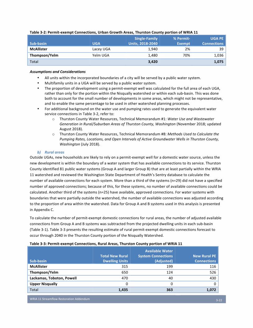
WRIA11StreamflowRestorationAddendum
3-22
Table3-2:Permit-exemptConnections,UrbanGrowthAreas,ThurstonCountyportionofWRIA11
Sub-basin UGASingle-Family
Units,2018-2040%Permit-Exempt
UGAPEConnections
McAllister LaceyUGA 1,940 2% 39
Thompson/Yelm YelmUGA 1,480 70% 1,036
Total 3,420 1,075
AssumptionsandConsiderations
• Allunitswithintheincorporatedboundariesofacitywillbeservedbyapublicwatersystem.• MultifamilyunitsinaUGAwillbeservedbyapublicwatersystem.• Theproportionofdevelopmentusingapermit-exemptwellwascalculatedforthefullareaofeachUGA,
ratherthanonlyfortheportionwithintheNisquallywatershedorwithineachsub-basin.Thiswasdonebothtoaccountforthesmallnumberofdevelopmentsinsomeareas,whichmightnotberepresentative,andtoenablethesamepercentagetobeusedinotherwatershedplanningprocesses.
• ForadditionalbackgroundonthewateruseandpumpingratesusedtogeneratetheequivalentwaterserviceconnectionsinTable3-2,referto:
o ThurstonCountyWaterResources,TechnicalMemorandum#1:WaterUseandWastewater
GenerationinRural/SuburbanAreasofThurstonCounty,Washington(November2018;updatedAugust2018).
o ThurstonCountyWaterResources,TechnicalMemorandum#8:MethodsUsedtoCalculatethe
PumpingRates,Locations,andOpenIntervalsofActiveGroundwaterWellsinThurstonCounty,
Washington(July2018).
b) RuralareasOutsideUGAs,newhouseholdsarelikelytorelyonapermit-exemptwellforadomesticwatersource,unlessthe
newdevelopmentiswithintheboundaryofawatersystemthathasavailableconnectionstoitsservice.Thurston
Countyidentified81publicwatersystems(GroupAandlargerGroupB)thatareatleastpartiallywithintheWRIA
11watershedandreviewedtheWashingtonStateDepartmentofHealth’sSentrydatabasetocalculatethe
numberofavailableconnectionsforeachsystem.Morethanathirdofthesystems(n=29)didnothaveaspecified
numberofapprovedconnections;becauseofthis,forthesesystems,nonumberofavailableconnectionscouldbe
calculated.Anotherthirdofthesystems(n=25)haveavailable,approvedconnections.Forwatersystemswith
boundariesthatwerepartiallyoutsidethewatershed,thenumberofavailableconnectionswasadjustedaccording
totheproportionofareawithinthewatershed.DataforGroupAandBsystemsusedinthisanalysisispresented
inAppendixC.
Tocalculatethenumberofpermit-exemptdomesticconnectionsforruralareas,thenumberofadjustedavailable
connectionsfromGroupAandBsystemswassubtractedfromtheprojecteddwellingunitsineachsub-basin
(Table3-1).Table3-3presentstheresultingestimateofruralpermit-exemptdomesticconnectionsforecastto
occurthrough2040intheThurstonCountyportionoftheNisquallyWatershed.
Table3-3:Permit-exemptConnections,RuralAreas,ThurstonCountyportionofWRIA11
Sub-basinTotalNewRuralDwellingUnits
AvailableWaterSystemConnections
(Adjusted)NewRuralPEConnections
McAllister 315 199 116
Thompson/Yelm 650 124 526
Lackamas,Toboton,Powell 470 40 430
UpperNisqually 0 0 0
Total 1,435 363 1,072

WRIA11StreamflowRestorationAddendum
3-23
AssumptionsandConsiderations
• Thisanalysisdoesnotconsiderthenumberofpotentialconnectionstowatersystemswithan“unspecified”numberofavailableconnectionsintheWashingtonDepartmentofHealthSentryDatabase.DOHgivesan“unspecified”designationwhenthereisenoughsourceandsystemcapacity,andwaterrights,toaddconnectionswithintheirapprovedservicearea.Thesesystemsarelikelytohavethemostexistingcapacitytoservenewconnections,and,becausetheyarenotincluded,thisanalysisunderestimatestheamountofavailablewatersystemconnections.
• AssumesnonewGroupAorlargerGroupBsystemswillbepermittedoverthe20-yearplanningperiod.• Assumesnoexistingsystemswillbepermittedtoexpandtheirserviceareaboundariesoverthe20-year
planningperiod,andnoadditionalconnectionswillbeavailablebeyondthecurrentlyspecified“availableconnections”withintheDOHSentrydatabase.Asnotedabove,thisislikelyanunderestimateofthenumberofavailableconnections,giventhehighproportionofsystemsthatdidnothaveinformationonapprovedconnections(“unspecified”).Inaddition,somewatersystemsmayhavewaterrightsthatexceedthenumberofconnectionsthatarecurrentlyapproved,andthusmaybeabletoexpandwithoutneedingtoapplyforadditionalwaterrights.
• Newdevelopmentwillconnecttoexistingpublicwatersystemswhenconnectionsareavailable.Thisassumptionisonlylikelyifnewdevelopmentislocatedwithinwatersystemboundaries,andifallavailableconnectionsaremadeavailabletonewdomesticuses.
Results
Insummary,ThurstonCountyestimatesabaselinedemandforslightlymorethan2,000newpermit-exempt
connectionsintheNisquallywatershedthrough2040(Table3-4).Averagedoverthe22-yearplanningperiod,this
equatestoapproximately100newpermit-exemptconnectionsperyear.
Table3-4:TotalEstimatedPermit-exemptConnections,ThurstonCountyportionofWRIA11,2018-2040
Sub-basinUGAPE
ConnectionsRuralPE
ConnectionsTotalPE
Connections
McAllister 39 116 155
Thompson/Yelm 1,036 526 1,562
Lackamas/Toboton/Powell - 430 430
UpperNisqually - 0 0
Total 1,075 1,072 2,147
DiscussionofResults
Thenumberofestimatedpermit-exemptconnectionsinThurstonCountyisalmostevenlysplitbetweenrural
areasandUGAs,withthelargestproportionintheThompson/Yelmsub-basin.Thelargenumberofpermit-exempt
connectionsinurbanareasisduetothelimitationsoftheCityofYelm’swaterutility,whichatthistimedoesnot
havetheserviceareaoravailableconnectionstoprovidewatertomuchoftheUGA.WereYelm’sutilityableto
providewaterserviceatthesameproportionastheCityofLacey(i.e.,were98%ofnewhousingunitsabletohook
uptoawaterutilityratherthanonly30%),thiswouldaddressnearlyhalfoftheprojectednewconnectionsforthe
ThurstonCountyportionofthewatershed.
Evenconsideringonlynewruralconnections,however,theThompson/Yelmsub-basinstandsoutastheareawith
thegreatestforecasteddemandongroundwater,withmorethan500projectednewpermit-exemptconnections.
TheLackamas/Toboton/Powellsub-basinhasthesecondhighestnumberofprojectedpermit-exemptconnections,
howeverthisestimateislikelyhighconsideringthatavailableconnectionstothelargestwatersysteminthesub-
basin,Clearwood,couldnotbecalculated.Clearwood’sGroupAsystemwouldlikelyservenewdevelopment
aroundClearLake,whichisthemostdenselydevelopedportionofthesub-basin.
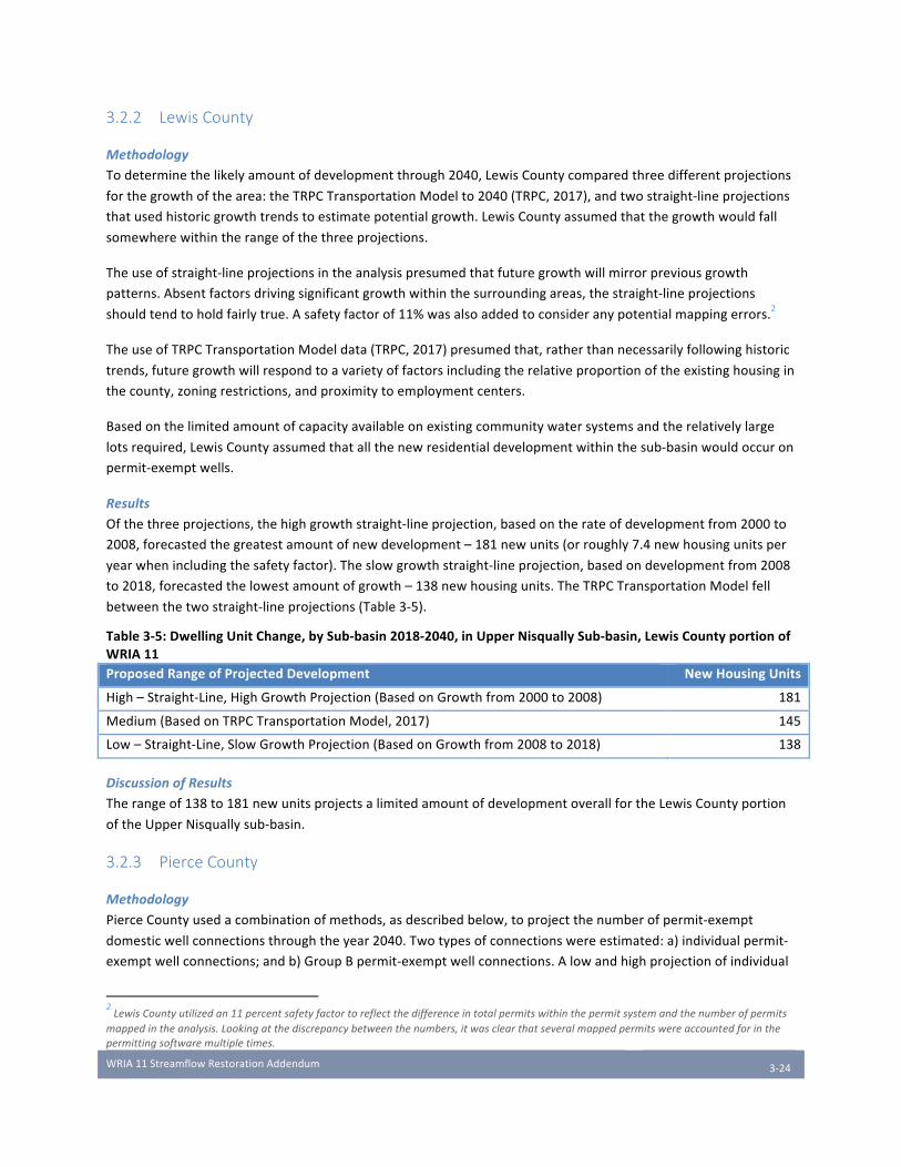
WRIA11StreamflowRestorationAddendum
3-24
3.2.2 Lewis County
Methodology
Todeterminethelikelyamountofdevelopmentthrough2040,LewisCountycomparedthreedifferentprojections
forthegrowthofthearea:theTRPCTransportationModelto2040(TRPC,2017),andtwostraight-lineprojections
thatusedhistoricgrowthtrendstoestimatepotentialgrowth.LewisCountyassumedthatthegrowthwouldfall
somewherewithintherangeofthethreeprojections.
Theuseofstraight-lineprojectionsintheanalysispresumedthatfuturegrowthwillmirrorpreviousgrowth
patterns.Absentfactorsdrivingsignificantgrowthwithinthesurroundingareas,thestraight-lineprojections
shouldtendtoholdfairlytrue.Asafetyfactorof11%wasalsoaddedtoconsideranypotentialmappingerrors.2
TheuseofTRPCTransportationModeldata(TRPC,2017)presumedthat,ratherthannecessarilyfollowinghistoric
trends,futuregrowthwillrespondtoavarietyoffactorsincludingtherelativeproportionoftheexistinghousingin
thecounty,zoningrestrictions,andproximitytoemploymentcenters.
Basedonthelimitedamountofcapacityavailableonexistingcommunitywatersystemsandtherelativelylarge
lotsrequired,LewisCountyassumedthatallthenewresidentialdevelopmentwithinthesub-basinwouldoccuron
permit-exemptwells.
Results
Ofthethreeprojections,thehighgrowthstraight-lineprojection,basedontherateofdevelopmentfrom2000to
2008,forecastedthegreatestamountofnewdevelopment–181newunits(orroughly7.4newhousingunitsper
yearwhenincludingthesafetyfactor).Theslowgrowthstraight-lineprojection,basedondevelopmentfrom2008
to2018,forecastedthelowestamountofgrowth–138newhousingunits.TheTRPCTransportationModelfell
betweenthetwostraight-lineprojections(Table3-5).
Table3-5:DwellingUnitChange,bySub-basin2018-2040,inUpperNisquallySub-basin,LewisCountyportionofWRIA11ProposedRangeofProjectedDevelopment NewHousingUnits
High–Straight-Line,HighGrowthProjection(BasedonGrowthfrom2000to2008) 181
Medium(BasedonTRPCTransportationModel,2017) 145
Low–Straight-Line,SlowGrowthProjection(BasedonGrowthfrom2008to2018) 138
DiscussionofResults
Therangeof138to181newunitsprojectsalimitedamountofdevelopmentoverallfortheLewisCountyportion
oftheUpperNisquallysub-basin.
3.2.3 Pierce County
Methodology
PierceCountyusedacombinationofmethods,asdescribedbelow,toprojectthenumberofpermit-exempt
domesticwellconnectionsthroughtheyear2040.Twotypesofconnectionswereestimated:a)individualpermit-
exemptwellconnections;andb)GroupBpermit-exemptwellconnections.Alowandhighprojectionofindividual
2LewisCountyutilizedan11percentsafetyfactortoreflectthedifferenceintotalpermitswithinthepermitsystemandthenumberofpermits
mappedintheanalysis.Lookingatthediscrepancybetweenthenumbers,itwasclearthatseveralmappedpermitswereaccountedforinthe
permittingsoftwaremultipletimes.
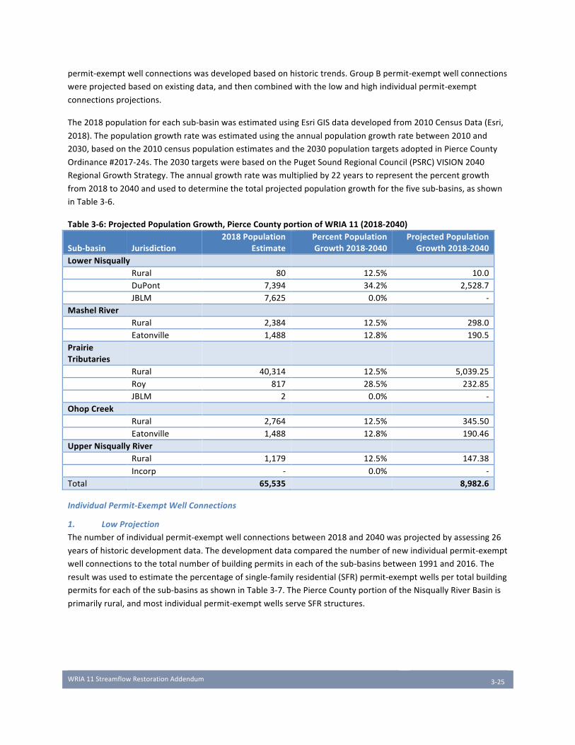
WRIA11StreamflowRestorationAddendum
3-25
permit-exemptwellconnectionswasdevelopedbasedonhistorictrends.GroupBpermit-exemptwellconnections
wereprojectedbasedonexistingdata,andthencombinedwiththelowandhighindividualpermit-exempt
connectionsprojections.
The2018populationforeachsub-basinwasestimatedusingEsriGISdatadevelopedfrom2010CensusData(Esri,
2018).Thepopulationgrowthratewasestimatedusingtheannualpopulationgrowthratebetween2010and
2030,basedonthe2010censuspopulationestimatesandthe2030populationtargetsadoptedinPierceCounty
Ordinance#2017-24s.The2030targetswerebasedonthePugetSoundRegionalCouncil(PSRC)VISION2040
RegionalGrowthStrategy.Theannualgrowthratewasmultipliedby22yearstorepresentthepercentgrowth
from2018to2040andusedtodeterminethetotalprojectedpopulationgrowthforthefivesub-basins,asshown
inTable3-6.
Table3-6:ProjectedPopulationGrowth,PierceCountyportionofWRIA11(2018-2040)
Sub-basin Jurisdiction2018Population
EstimatePercentPopulationGrowth2018-2040
ProjectedPopulationGrowth2018-2040
LowerNisqually Rural 80 12.5% 10.0 DuPont 7,394 34.2% 2,528.7 JBLM 7,625 0.0% -MashelRiver Rural 2,384 12.5% 298.0 Eatonville 1,488 12.8% 190.5PrairieTributaries
Rural 40,314 12.5% 5,039.25 Roy 817 28.5% 232.85 JBLM 2 0.0% -OhopCreek Rural 2,764 12.5% 345.50 Eatonville 1,488 12.8% 190.46UpperNisquallyRiver Rural 1,179 12.5% 147.38 Incorp - 0.0% -Total 65,535 8,982.6
IndividualPermit-ExemptWellConnections
1. LowProjection
Thenumberofindividualpermit-exemptwellconnectionsbetween2018and2040wasprojectedbyassessing26
yearsofhistoricdevelopmentdata.Thedevelopmentdatacomparedthenumberofnewindividualpermit-exempt
wellconnectionstothetotalnumberofbuildingpermitsineachofthesub-basinsbetween1991and2016.The
resultwasusedtoestimatethepercentageofsingle-familyresidential(SFR)permit-exemptwellspertotalbuilding
permitsforeachofthesub-basinsasshowninTable3-7.ThePierceCountyportionoftheNisquallyRiverBasinis
primarilyrural,andmostindividualpermit-exemptwellsserveSFRstructures.
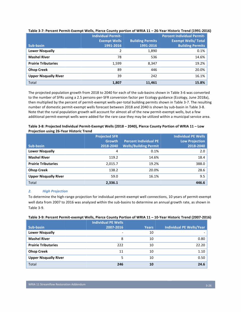
WRIA11StreamflowRestorationAddendum
3-26
Table3-7:PercentPermit-ExemptWells,PierceCountyportionofWRIA11–26-YearHistoricTrend(1991-2016)
Sub-basin
IndividualPermit-ExemptWells
1991-2016BuildingPermits
1991-2016
PercentIndividualPermit-ExemptWells/Total
BuildingPermitsLowerNisqually 2 1,890 0.1%
MashelRiver 78 536 14.6%
PrairieTributaries 1,599 8,347 19.2%
OhopCreek 89 446 20.0%
UpperNisquallyRiver 39 242 16.1%
Total 1,807 11,461 15.8%Theprojectedpopulationgrowthfrom2018to2040foreachofthesub-basinsshowninTable3-6wasconvertedtothenumberofSFRsusinga2.5persons-per-SFRconversionfactorperEcologyguidance(Ecology,June2018a),thenmultipliedbythepercentofpermit-exemptwells-per-totalbuildingpermitsshowninTable3-7.Theresultingnumberofdomesticpermit-exemptwellsforecastbetween2018and2040isshownbysub-basininTable3-8.Notethattheruralpopulationgrowthwillaccountforalmostallofthenewpermit-exemptwells,butafewadditionalpermit-exemptwellswereaddedfortherarecasetheymaybeutilizedwithinamunicipalservicearea.Table3-8:ProjectedIndividualPermit-ExemptWells(2018–2040),PierceCountyPortionofWRIA11–LowProjectionusing26-YearHistoricTrend
Sub-basin
ProjectedSFRGrowth
2018-2040PercentIndividualPEWells/BuildingPermit
IndividualPEWellsLowProjection
2018-2040LowerNisqually 4 0.1% 2.0
MashelRiver 119.2 14.6% 18.4
PrairieTributaries 2,015.7 19.2% 388.0
OhopCreek 138.2 20.0% 28.6
UpperNisquallyRiver 59.0 16.1% 9.5
Total 2,336.1 446.6
2. HighProjection
Todeterminethehigh-rangeprojectionforindividualpermit-exemptwellconnections,10yearsofpermit-exempt
welldatafrom2007to2016wasanalyzedwithinthesub-basinstodetermineanannualgrowthrate,asshownin
Table3-9.
Table3-9:PercentPermit-exemptWells,PierceCountyPortionofWRIA11–10-YearHistoricTrend(2007-2016)
Sub-basin
IndividualPEWells2007-2016 Years IndividualPEWells/Year
LowerNisqually - 10 -
MashelRiver 8 10 0.80
PrairieTributaries 222 10 22.20
OhopCreek 11 10 1.10
UpperNisquallyRiver 5 10 0.50
Total 246 10 24.6
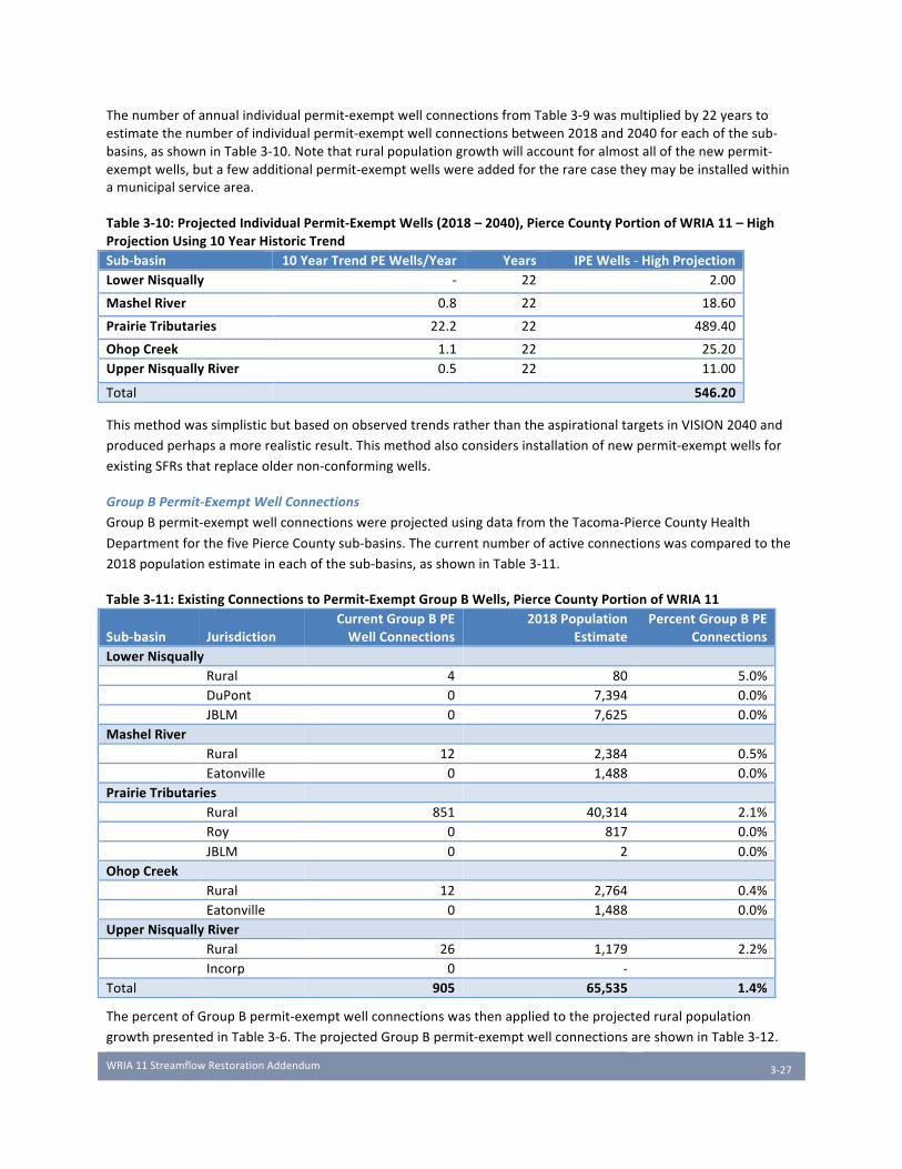
WRIA11StreamflowRestorationAddendum
3-27
Thenumberofannualindividualpermit-exemptwellconnectionsfromTable3-9wasmultipliedby22yearstoestimatethenumberofindividualpermit-exemptwellconnectionsbetween2018and2040foreachofthesub-basins,asshowninTable3-10.Notethatruralpopulationgrowthwillaccountforalmostallofthenewpermit-exemptwells,butafewadditionalpermit-exemptwellswereaddedfortherarecasetheymaybeinstalledwithinamunicipalservicearea.
Table3-10:ProjectedIndividualPermit-ExemptWells(2018–2040),PierceCountyPortionofWRIA11–HighProjectionUsing10YearHistoricTrendSub-basin 10YearTrendPEWells/Year Years IPEWells-HighProjectionLowerNisqually - 22 2.00
MashelRiver 0.8 22 18.60
PrairieTributaries 22.2 22 489.40
OhopCreek 1.1 22 25.20UpperNisquallyRiver 0.5 22 11.00
Total 546.20
ThismethodwassimplisticbutbasedonobservedtrendsratherthantheaspirationaltargetsinVISION2040and
producedperhapsamorerealisticresult.Thismethodalsoconsidersinstallationofnewpermit-exemptwellsfor
existingSFRsthatreplaceoldernon-conformingwells.
GroupBPermit-ExemptWellConnections
GroupBpermit-exemptwellconnectionswereprojectedusingdatafromtheTacoma-PierceCountyHealth
DepartmentforthefivePierceCountysub-basins.Thecurrentnumberofactiveconnectionswascomparedtothe
2018populationestimateineachofthesub-basins,asshowninTable3-11.
Table3-11:ExistingConnectionstoPermit-ExemptGroupBWells,PierceCountyPortionofWRIA11
Sub-basin JurisdictionCurrentGroupBPEWellConnections
2018PopulationEstimate
PercentGroupBPEConnections
LowerNisqually Rural 4 80 5.0% DuPont 0 7,394 0.0% JBLM 0 7,625 0.0%MashelRiver Rural 12 2,384 0.5% Eatonville 0 1,488 0.0%PrairieTributaries Rural 851 40,314 2.1% Roy 0 817 0.0% JBLM 0 2 0.0%OhopCreek Rural 12 2,764 0.4% Eatonville 0 1,488 0.0%UpperNisquallyRiver Rural 26 1,179 2.2% Incorp 0 - Total 905 65,535 1.4%
ThepercentofGroupBpermit-exemptwellconnectionswasthenappliedtotheprojectedruralpopulation
growthpresentedinTable3-6.TheprojectedGroupBpermit-exemptwellconnectionsareshowninTable3-12.
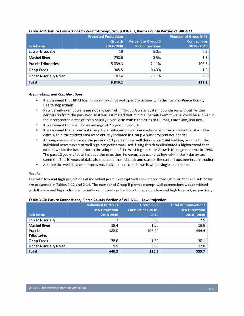
WRIA11StreamflowRestorationAddendum
3-28
Table3-12:FutureConnectionstoPermit-ExemptGroupBWells,PierceCountyPortionofWRIA11
Sub-basin
ProjectedPopulationGrowth
2018-2040PercentofGroupB
PEConnections
NumberofGroupBPEConnections2018-2040
LowerNisqually 10 5.0% 0.5
MashelRiver 298.0 0.5% 1.5
PrairieTributaries 5,039.3 2.11% 106.3
OhopCreek 345.5 0.43% 1.5
UpperNisquallyRiver 147.4 2.21% 3.3
Total 5,840.2 113.1
AssumptionsandConsiderations
• ItisassumedthatJBLMhasnopermit-exemptwellsperdiscussionswiththeTacoma-PierceCountyHealthDepartment.
• Newpermit-exemptwellsarenotallowedwithinGroupAwatersystemboundarieswithoutwrittenpermissionfromthepurveyor,soitwasestimatedthatminimalpermit-exemptwellswouldbeallowedintheincorporatedareasoftheNisquallyRiverBasinwithinthecitiesofDuPont,Eatonville,andRoy.
• Itisassumedtherewillbeanaverageof2.5peopleperSFR.• ItisassumedthatallcurrentGroupBpermit-exemptwellconnectionsoccurredoutsidethecities.The
citieswithinthestudiedareawereentirelyincludedinGroupAwatersystemboundaries.• Althoughmoredataexists,theprevious10yearsofnewwelldataversustotalbuildingpermitsforthe
individualpermit-exemptwellhighprojectionwasused.UsingthisdataeliminatedahighertrendthatexistedwithinthebasinpriortotheadoptionoftheWashingtonStateGrowthManagementActin1990.Thepast10yearsofdataincludedtherecession;however,peaksandvalleyswithintheindustryarecommon.The10yearsofdataalsoincludedthelastpeakandstartofthecurrentupsurgeinconstruction.
• Assumethewelldatausedrepresentsindividualresidentialwellswithasingleconnection.
Results
Thetotallowandhighprojectionsofindividualpermit-exemptwellconnectionsthrough2040foreachsub-basin
arepresentedinTables2-13and2-14.ThenumberofGroupBpermit-exemptwellconnectionswascombined
withthelowandhighindividualpermit-exemptwellsprojectionstodevelopalowandhighforecast,respectively.
Table3-13:FutureConnections,PierceCountyPortionofWRIA11–LowProjection
Sub-basin
IndividualPEWellsLowProjection
2018-2040
GroupBPEConnections2018-
2040
TotalPEConnectionsLowProjection
2018-2040LowerNisqually 2 0.50 2.5MashelRiver 18.4 1.50 19.9PrairieTributaries
388.0 106.40 494.4
OhopCreek 28.6 1.50 30.1UpperNisquallyRiver 9.5 3.30 12.8Total 446.5 113.2 559.7
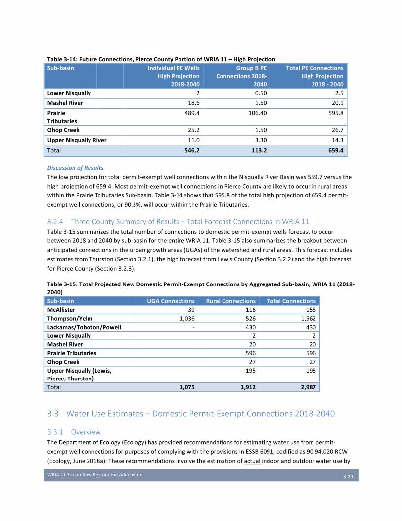
WRIA11StreamflowRestorationAddendum
3-29
Table3-14:FutureConnections,PierceCountyPortionofWRIA11–HighProjectionSub-basin IndividualPEWells
HighProjection2018-2040
GroupBPEConnections2018-
2040
TotalPEConnectionsHighProjection
2018-2040LowerNisqually 2 0.50 2.5
MashelRiver 18.6 1.50 20.1
PrairieTributaries
489.4 106.40 595.8
OhopCreek 25.2 1.50 26.7
UpperNisquallyRiver 11.0 3.30 14.3
Total 546.2 113.2 659.4
DiscussionofResults
Thelowprojectionfortotalpermit-exemptwellconnectionswithintheNisquallyRiverBasinwas559.7versusthe
highprojectionof659.4.Mostpermit-exemptwellconnectionsinPierceCountyarelikelytooccurinruralareas
withinthePrairieTributariesSub-basin.Table3-14showsthat595.8ofthetotalhighprojectionof659.4permit-
exemptwellconnections,or90.3%,willoccurwithinthePrairieTributaries.
3.2.4 Three-County Summary of Results – Total Forecast Connections in WRIA 11 Table3-15summarizesthetotalnumberofconnectionstodomesticpermit-exemptwellsforecasttooccur
between2018and2040bysub-basinfortheentireWRIA11.Table3-15alsosummarizesthebreakoutbetween
anticipatedconnectionsintheurbangrowthareas(UGAs)ofthewatershedandruralareas.Thisforecastincludes
estimatesfromThurston(Section3.2.1),thehighforecastfromLewisCounty(Section3.2.2)andthehighforecast
forPierceCounty(Section3.2.3).
Table3-15:TotalProjectedNewDomesticPermit-ExemptConnectionsbyAggregatedSub-basin,WRIA11(2018-2040)Sub-basin UGAConnections RuralConnections TotalConnectionsMcAllister 39 116 155Thompson/Yelm 1,036 526 1,562Lackamas/Toboton/Powell - 430 430LowerNisqually 2 2MashelRiver 20 20PrairieTributaries 596 596OhopCreek 27 27UpperNisqually(Lewis,Pierce,Thurston)
195 195
Total 1,075 1,912 2,987
3.3 Water Use Estimates – Domestic Permit-Exempt Connections 2018-2040
3.3.1 Overview TheDepartmentofEcology(Ecology)hasprovidedrecommendationsforestimatingwaterusefrompermit-
exemptwellconnectionsforpurposesofcomplyingwiththeprovisionsinESSB6091,codifiedas90.94.020RCW
(Ecology,June2018a).Theserecommendationsinvolvetheestimationofactualindoorandoutdoorwateruseby
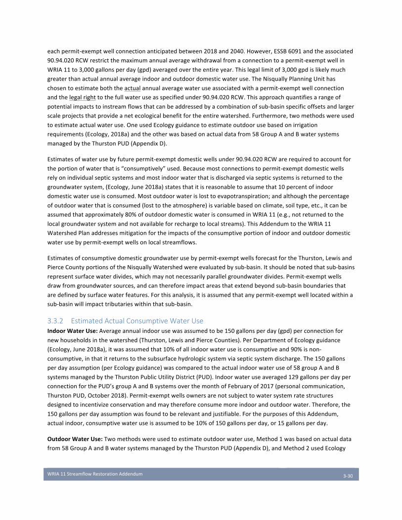
WRIA11StreamflowRestorationAddendum
3-30
eachpermit-exemptwellconnectionanticipatedbetween2018and2040.However,ESSB6091andtheassociated
90.94.020RCWrestrictthemaximumannualaveragewithdrawalfromaconnectiontoapermit-exemptwellin
WRIA11to3,000gallonsperday(gpd)averagedovertheentireyear.Thislegallimitof3,000gpdislikelymuch
greaterthanactualannualaverageindoorandoutdoordomesticwateruse.TheNisquallyPlanningUnithas
chosentoestimateboththeactualannualaveragewateruseassociatedwithapermit-exemptwellconnection
andthelegalrighttothefullwateruseasspecifiedunder90.94.020RCW.Thisapproachquantifiesarangeof
potentialimpactstoinstreamflowsthatcanbeaddressedbyacombinationofsub-basinspecificoffsetsandlarger
scaleprojectsthatprovideanetecologicalbenefitfortheentirewatershed.Furthermore,twomethodswereused
toestimateactualwateruse.OneusedEcologyguidancetoestimateoutdoorusebasedonirrigation
requirements(Ecology,2018a)andtheotherwasbasedonactualdatafrom58GroupAandBwatersystems
managedbytheThurstonPUD(AppendixD).
Estimatesofwaterusebyfuturepermit-exemptdomesticwellsunder90.94.020RCWarerequiredtoaccountfor
theportionofwaterthatis“consumptively”used.Becausemostconnectionstopermit-exemptdomesticwells
relyonindividualsepticsystemsandmostindoorwaterthatisdischargedviasepticsystemsisreturnedtothe
groundwatersystem,(Ecology,June2018a)statesthatitisreasonabletoassumethat10percentofindoor
domesticwateruseisconsumed.Mostoutdoorwaterislosttoevapotranspiration;andalthoughthepercentage
ofoutdoorwaterthatisconsumed(losttotheatmosphere)isvariablebasedonclimate,soiltype,etc.,itcanbe
assumedthatapproximately80%ofoutdoordomesticwaterisconsumedinWRIA11(e.g.,notreturnedtothe
localgroundwatersystemandnotavailableforrechargetolocalstreams).ThisAddendumtotheWRIA11
WatershedPlanaddressesmitigationfortheimpactsoftheconsumptiveportionofindoorandoutdoordomestic
waterusebypermit-exemptwellsonlocalstreamflows.
Estimatesofconsumptivedomesticgroundwaterusebypermit-exemptwellsforecastfortheThurston,Lewisand
PierceCountyportionsoftheNisquallyWatershedwereevaluatedbysub-basin.Itshouldbenotedthatsub-basins
representsurfacewaterdivides,whichmaynotnecessarilyparallelgroundwaterdivides.Permit-exemptwells
drawfromgroundwatersources,andcanthereforeimpactareasthatextendbeyondsub-basinboundariesthat
aredefinedbysurfacewaterfeatures.Forthisanalysis,itisassumedthatanypermit-exemptwelllocatedwithina
sub-basinwillimpacttributarieswithinthatsub-basin.
3.3.2 Estimated Actual Consumptive Water Use IndoorWaterUse:Averageannualindoorusewasassumedtobe150gallonsperday(gpd)perconnectionfor
newhouseholdsinthewatershed(Thurston,LewisandPierceCounties).PerDepartmentofEcologyguidance
(Ecology,June2018a),itwasassumedthat10%ofallindoorwateruseisconsumptiveand90%isnon-
consumptive,inthatitreturnstothesubsurfacehydrologicsystemviasepticsystemdischarge.The150gallons
perdayassumption(perEcologyguidance)wascomparedtotheactualindoorwateruseof58groupAandB
systemsmanagedbytheThurstonPublicUtilityDistrict(PUD).Indoorwateruseaveraged129gallonsperdayper
connectionforthePUD’sgroupAandBsystemsoverthemonthofFebruaryof2017(personalcommunication,
ThurstonPUD,October2018).Permit-exemptwellsownersarenotsubjecttowatersystemratestructures
designedtoincentivizeconservationandmaythereforeconsumemoreindoorandoutdoorwater.Therefore,the
150gallonsperdayassumptionwasfoundtoberelevantandjustifiable.ForthepurposesofthisAddendum,
actualindoor,consumptivewateruseisassumedtobe10%of150gallonsperday,or15gallonsperday.
OutdoorWaterUse:Twomethodswereusedtoestimateoutdoorwateruse,Method1wasbasedonactualdata
from58GroupAandBwatersystemsmanagedbytheThurstonPUD(AppendixD),andMethod2usedEcology
WRIA11StreamflowRestorationAddendum
3-31
guidance(Ecology,June2018a)toestimateoutdoorusebasedonbasin-specificirrigationrequirementsand
monthlyprecipitation.
Method1:Toestimateaverageannualoutdoorwateruse,thePlanningUnitassessedactualwaterusage
dataforGroupAandBwatersystemsoperatedbytheThurstonPUDin2015,2016and2017(see
AppendixD).Onaverage,thosewatersystemsusedatotalof183gpd/householdconnectionperyear
overthethree-yeartimeperiod.AftersubtractingthePUD’sestimatedindoorwateruse,annualoutdoor
wateruseis,onaverage,approximately50gpd/householdfortheGroupAandBSystemsmanagedby
theThurstonPUDbetween2015and2017.Droughtconditionsoccurredin2015andcouldhaveimpacted
estimatesofwateruseinoneoftwoways:summerwaterusecouldhavebeenhigherthanusual,ormore
stringentconservationratesappliedbyThurstonPUDmayhaveincentivizedconservation.PlanningUnit
membersfeltthatitwasimportanttoconsiderexcessusebypermit-exemptwellownerswhoarenot
subjecttoPUDrates,butaresubjecttothecostsofpumping.ThePlanningUnitassumedaverageannual
outdoorwateruseassociatedwithpermit-exemptwellsisdoublethatobservedbythePUD.Therefore,
forthisanalysis,itisassumedthateachhouseholdutilizes100gpd/householdconnectionforoutdoor
usesonanannualaverage(100%morethantheirGroupAandBcounterparts).PerEcologyguidance
(Ecology,June2018a),80%ofthatoutdooruseisconsideredconsumptive,asthatwaterisnotdirectly
returnedtothegroundwatersystem.
Method2:ThePlanningUnitalsoappliedEcologyguidance(Ecology,June2018a)toprovideasecondestimateofoutdoorconsumptiveusebasedonstandardcropirrigationrequirements.Assumptionsfor
thismethodincludedaverageirrigatedacreage,irrigationefficiencyandirrigationrequirementsusing
informationfromtheOlympiaclimatestation(NaturalResourceConservationService,1997).Application
ofthismethodologytoWRIA11assumedthatanaverageof0.2acresofturforpasturewereirrigatedper
permit-exemptwellconnection,andthatirrigationefficiencyinruralareasofWRIA11was90%.The
estimateof0.2irrigatedacresperparcelisdrawnfromastudydoneforWhatcomCountyusingsatellite
imagerytoestimatearealextentofirrigation(RH2Engineering,August2018).Thisstudyfoundthatthe
averageirrigatedlawn/gardensizeforahomeservedbyapermit-exemptwellfordomesticpurposesin
WhatcomCountywas0.2acres.
Rationaleforthe90%irrigationapplicationrateefficiencyinclude:
• Forrurallanduses,therearegenerallylessimpermeablesurfaces.
• Notallthewaterlandingonasidewalkisevaporated,somewillrunoffandinfiltrate.
• TemperaturesinWRIA11aregenerallylowerthaneasternWashingtonareassuchasSpokanewhere75%applicationefficiencyhasbeenused.
• ThereisgenerallylesswindinWRIA11thaninareasineasternWashingtonresultinginlessevaporation.
• Manypermit-exemptwellusersuserainbird-typesprinklersordripirrigationratherthanthepop-uptypeonautomaticirrigationsystemsthatresultinmorespray,resultinginlessoverallevapotranspiration.
Perconnectionindooruse,andoutdoorusecalculatedusingbothmethodsdescribedabovearesummarizedin
Table3-16.
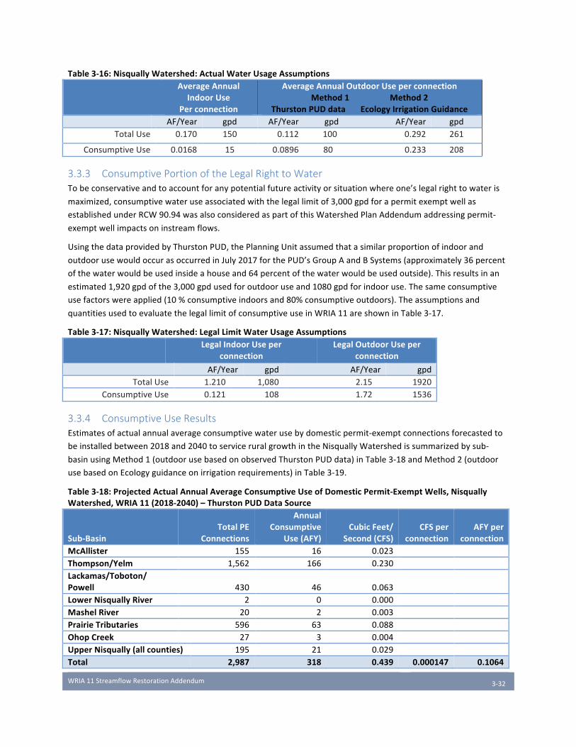
WRIA11StreamflowRestorationAddendum
3-32
Table3-16:NisquallyWatershed:ActualWaterUsageAssumptions AverageAnnual
IndoorUsePerconnection
AverageAnnualOutdoorUseperconnectionMethod1Method2
ThurstonPUDdataEcologyIrrigationGuidance AF/Year gpd AF/Year gpd AF/Year gpd
TotalUse 0.170 150 0.112 100 0.292 261
ConsumptiveUse 0.0168 15 0.0896 80 0.233 208
3.3.3 Consumptive Portion of the Legal Right to Water Tobeconservativeandtoaccountforanypotentialfutureactivityorsituationwhereone’slegalrighttowateris
maximized,consumptivewateruseassociatedwiththelegallimitof3,000gpdforapermitexemptwellas
establishedunderRCW90.94wasalsoconsideredaspartofthisWatershedPlanAddendumaddressingpermit-
exemptwellimpactsoninstreamflows.
UsingthedataprovidedbyThurstonPUD,thePlanningUnitassumedthatasimilarproportionofindoorand
outdoorusewouldoccurasoccurredinJuly2017forthePUD’sGroupAandBSystems(approximately36percent
ofthewaterwouldbeusedinsideahouseand64percentofthewaterwouldbeusedoutside).Thisresultsinan
estimated1,920gpdofthe3,000gpdusedforoutdooruseand1080gpdforindooruse.Thesameconsumptive
usefactorswereapplied(10%consumptiveindoorsand80%consumptiveoutdoors).Theassumptionsand
quantitiesusedtoevaluatethelegallimitofconsumptiveuseinWRIA11areshowninTable3-17.
Table3-17:NisquallyWatershed:LegalLimitWaterUsageAssumptions LegalIndoorUseper
connectionLegalOutdoorUseper
connection
AF/Year gpd AF/Year gpdTotalUse 1.210 1,080 2.15 1920
ConsumptiveUse 0.121 108 1.72 1536
3.3.4 Consumptive Use Results Estimatesofactualannualaverageconsumptivewaterusebydomesticpermit-exemptconnectionsforecastedto
beinstalledbetween2018and2040toserviceruralgrowthintheNisquallyWatershedissummarizedbysub-
basinusingMethod1(outdoorusebasedonobservedThurstonPUDdata)inTable3-18andMethod2(outdoor
usebasedonEcologyguidanceonirrigationrequirements)inTable3-19.
Table3-18:ProjectedActualAnnualAverageConsumptiveUseofDomesticPermit-ExemptWells,NisquallyWatershed,WRIA11(2018-2040)–ThurstonPUDDataSource
Sub-BasinTotalPE
Connections
AnnualConsumptive
Use(AFY)CubicFeet/
Second(CFS)CFSper
connectionAFYper
connectionMcAllister 155 16 0.023 Thompson/Yelm 1,562 166 0.230 Lackamas/Toboton/Powell 430 46 0.063 LowerNisquallyRiver 2 0 0.000 MashelRiver 20 2 0.003 PrairieTributaries 596 63 0.088 OhopCreek 27 3 0.004 UpperNisqually(allcounties) 195 21 0.029 Total 2,987 318 0.439 0.000147 0.1064
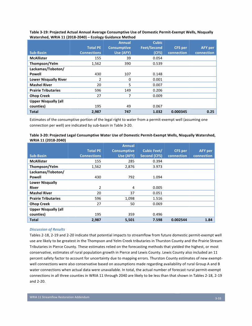
WRIA11StreamflowRestorationAddendum
3-33
Table3-19:ProjectedActualAnnualAverageConsumptiveUseofDomesticPermit-ExemptWells,NisquallyWatershed,WRIA11(2018-2040)–EcologyGuidanceMethod
Sub-BasinTotalPE
Connections
AnnualConsumptive
Use(AFY)
CubicFeet/Second
(CFS)CFSper
connectionAFYper
connectionMcAllister 155 39 0.054 Thompson/Yelm 1,562 390 0.539 Lackamas/Toboton/Powell 430 107 0.148 LowerNisquallyRiver 2 0 0.001 MashelRiver 20 5 0.007 PrairieTributaries 596 149 0.206 OhopCreek 27 7 0.009 UpperNisqually(allcounties) 195 49 0.067 Total 2,987 747 1.032 0.000345 0.25
Estimatesoftheconsumptiveportionofthelegalrighttowaterfromapermit-exemptwell(assumingone
connectionperwell)areindicatedbysub-basininTable3-20.
Table3-20:ProjectedLegalConsumptiveWaterUseofDomesticPermit-ExemptWells,NisquallyWatershed,WRIA11(2018-2040)
Sub-BasinTotalPE
Connections
AnnualConsumptive
Use(AFY)CubicFeet/
Second(CFS)CFSper
connectionAFYper
connectionMcAllister 155 285 0.394 Thompson/Yelm 1,562 2,876 3.973 Lackamas/Toboton/Powell 430 792 1.094 LowerNisquallyRiver 2 4 0.005 MashelRiver 20 37 0.051 PrairieTributaries 596 1,098 1.516 OhopCreek 27 50 0.069 UpperNisqually(allcounties) 195 359 0.496 Total 2,987 5,501 7.598 0.002544 1.84
DiscussionofResults
Tables2-18,2-19and2-20indicatethatpotentialimpactstostreamflowfromfuturedomesticpermit-exemptwell
usearelikelytobegreatestintheThompsonandYelmCreektributariesinThurstonCountyandthePrairieStream
TributariesinPierceCounty.Theseestimatesreliedontheforecastingmethodsthatyieldedthehighest,ormost
conservative,estimatesofruralpopulationgrowthinPierceandLewisCounty.LewisCountyalsoincludedan11
percentsafetyfactortoaccountforuncertaintyduetomappingerrors.ThurstonCountyestimatesofnewexempt-
wellconnectionswerealsoconservativebasedonassumptionsmaderegardingavailabilityofruralGroupAandB
waterconnectionswhenactualdatawereunavailable.Intotal,theactualnumberofforecastruralpermit-exempt
connectionsinallthreecountiesinWRIA11through2040arelikelytobelessthanthatshowninTables2-18,2-19
and2-20.

WRIA11StreamflowRestorationAddendum
3-34
Forecastedaverageannualwaterusebypermit-exemptwellsinallofWRIA11isexpectedtorangebetween318
and747AF/Yearor0.44and1.03cfsbasedonthetwomethodsusedforestimatingoutdoorconsumptivewater
use.Actualaverageannualwateruseisestimatedtobe0.000147to0.000345cfsor0.106to0.25AFYper
connection.Itshouldbenotedthatactualusefluctuatesovertheyearandishighestinthewarmsummermonths
andlowestinwintermonthswhenlittletonooutdoorirrigationoccurs.
WRIA11StreamflowRestorationAddendum
4-35
Chapter 4 Salmon Habitat Projects with Instream Flow
and Net Ecological Benefits
4.1 Net Ecological Benefit and Salmon Recovery Goals
4.1.1 Defining Net Ecological Benefit for the Nisqually Watershed InitsInterimGuidanceforDeterminingNetEcologicalBenefit(Publication18-11-009,Ecology2018b),the
DepartmentofEcologyestablishedcriteriafordeterminingif“anticipatedbenefitstoinstreamresourcesfrom
actionsdesignedtorestorestreamflowwilloffsetandexceedtheprojectedimpactstoinstreamresourcesfrom
newwateruse”.Theguidancefurtherspecifiesthatnetecologicalbenefit(NEB)maybeachievedbya
combinationofwateroffsetprojectswithdirectflowbenefits,andnon-wateroffsetprojects,providing“ecological
benefitsbyenhancingaquaticsystemstoimprovecapacitytosupportviablepopulationsofnativespecies.”Water
offsetprojectsandpoliciesarediscussedinChapters5and6throughsub-basin-specificmicro-mitigation
strategiestorestorestreamflowsimpactedbynewpermit-exemptwelldevelopmentwithinsub-basinsoverthe
next20years.ThischapteraddressesthebroaderquestionofNEBthrough“macro”orwatershed-scalehabitat
projectswithbothflowbenefitsandecologicalbenefitsessentialtonativesalmonpopulations.
GiventhecriticalstateofsalmonrecoveryintheNisqually,thePlanningUnitunderstandstheStreamflow
RestorationAct’sNEBrequirementasamandateforalong-termapproachtowaterplanningthatbalances
development,agriculturalandindustrialneedswiththeimperativeofrestoringaself-sustaining,salmon-
supportingwatershedecosystem.AddressingthiscentralissuerequiredthePlanningUnittothinkaboutNEBata
watershed-widescalebeyondthetwenty-yeartimeframe.Permit-exemptwelluseisonerelativelysmall
componentofthechallengetheNisquallyWatershedwillfaceinbalancingitswaterbudgetforsalmonandhuman
usesoverthecomingdecades,asclimatechangealtersprecipitation,storage,andflowpatternsfortheentire
basin.Asinpreviouswatershedplanningefforts,themacro-mitigationstrategiesinthisAddendumarealigned
withlonger-termeffortstomanagewaterresourceseffectivelyinthefaceofthesegrowingchallenges,including
theForestandWaterClimateAdaptationPlanfortheNisquallyWatershed(Greene,2014)andtheNisqually
CommunityForest’sUpperBusyWildUnitForestManagementPlan(NisquallyCommunityForest,2016),along
withtheNisquallyChinookRecoveryPlan(NisquallyChinookRecoveryTeam,2001)andDraftNisquallySteelhead
RecoveryPlan(NisquallySteelheadRecoveryTeam,2014).Ofthese,theChinookandSteelheadRecoveryPlans
providethemostcomprehensivescientificframework,aswellastheunderlyingrationale,forwatershed-wideand
basin-specificactionsnecessarytorestoreandsustainfunctioningriparianecosystemsforsalmon.
TheNisquallyIndianTribeissignatorytotheMedicineCreekTreatyof1854,inwhichtheyreservedtherightto
fish,hunt,andgatherforever.ThepromisemadetotheTribewasthatsalmonandsalmonfishingwouldcontinue
tobeavailableintothefutureasithadbeeninthepast.Butoverthepast160yearstheregionhaschanged
dramatically,includinglossandimpactstothefreshandmarinehabitatsthatarecriticaltothesurvivalofsalmon,
tothepointwheretherunsofsalmonarelessthan10%ofhistoriclevels.ThedeclineofwildChinookand
steelheadhasbeensoprecipitousthattheyarebothlistedasThreatenedundertheEndangeredSpeciesAct.
TheTribe’sfishingseasonshavedecreasedalongwiththedemiseofthevariousrunsofsalmonintheNisqually
River.IntheyearsimmediatelyfollowingthefederalcourtdecisionupholdingtreatyrightsinUnitedStatesv.
Washington(1974),knownastheBoldtdecision,theNisquallyTribefishedsustainablyforeightmonthsofthe

WRIA11StreamflowRestorationAddendum
4-36
yearonthevariousrunsofsalmonreturningtotheNisquallyRiver.Thefisheryreacheditsalltimelowintermsof
timeontheriverin2015,whentheTribefishedatotalofeightdays.
TheNisquallyTribehasledtheefforttodevelopandimplementrecoveryplansforFallChinookandsteelhead.
Therearenumberofactionableelementsintheseplansthatfocusonhabitatprotectionandrestorationfromthe
NisquallyestuarytotheheadwatersoftheMashelRiver.Theseplanshaveidentifiedsummerstreamflowin
severalcriticaltributariesinthewatershed(theMashelRiverandOhop,Muck,andYelmCreeks)thatarevitalto
therecoveryofbothlistedspecies.TheTribeisinterestedindefiningnetecologicalbenefitatascaleandfocus
thatwillhelpresolvetheissuesaroundsalmonrecoverywhichseverelyconstraintheirtreatyfishingrights,and
thePlanningUnitconcurswiththisapproach.
4.1.2 Aligning Salmon Recovery Habitat Initiatives with Streamflow Restoration Planning Thebenefitsassociatedwiththemacro-scaleprojectsdescribedinthischaptercontributetothemitigationof
futurepermit-exemptwells.However,recoveringsalmonidpopulationsandtheecosystemfunctionsnecessaryto
supportthemisaneffortthatgoesbeyondmanagingfortheeffectsofnewpermit-exemptwaterwithdrawals
through2040.ThePlanningUnit’sintentistoaddressNEBbyintegratingtherequirementsoftheStreamflow
RestorationActwithexistingwatershedandEndangeredSpeciesAct(ESA)recoveryplans,namelytheNisqually
ChinookRecoveryPlan(NisquallyChinookRecoveryTeam,2001)andDraftNisquallySteelheadRecoveryPlan
(NisquallySteelheadRecoveryTeam,2014).TheNisquallyIndianTribeistheLeadEntityforsalmonrecoveryinthe
watershedandhasworkedcloselywithpartnerstodevelopcomprehensiveandholisticapproachestoachieving
salmonidpopulationswithlong-termviability.Thisisconsistentwiththe2003NisquallyWatershedManagement
Plan,whichdeferredtotheNisquallyChinookRecoveryPlanforaddressingthemajorityofhabitatcomponentsin
thePlan(seeGolder,2003,Section11.2.2).
TheTribe’sstrategyisbasedontheEcosystemDiagnosisandTreatment(EDT)model,whichidentifieskeyfactors
limitingsalmonpopulations,includingabundance,spatialdiversity,geneticdiversity,andproductivity,ineach
reachofthewatershed.Recoveryprojectsaredevelopedandrankedatthereachandsub-basinlevelwhereEDT
indicatesthegreatestpossiblereturnoninvestmentforthetwoESA-listedsalmonpopulations.Thehighest
priorityhabitateffortsintheNisquallyWatershedarecurrentlyfocusedonitsmajorsalmon-bearingtributaries.
ThemainstemNisquallyRiverisoflessconcernforstreamflowandsalmonidhabitatthanarethetributaries.
MainstemflowsbelowTacomaPower’sNisquallyHydroelectricProject(AlderandLaGrandedams)aresetby
federallicenserequirementsandmanagedseasontoseasonbytheNisquallyRiverCoordinatingCommittee.
Reachesabovethedamsdonotsupportanadromousfishpopulations.Likewise,mainstemhabitatiswell-
protected,with75%ofshorelineintheanadromouszone(belowLaGrandeDam)inpermanentstewardship.
Majortributaries,incontrast,containcriticalsalmonhabitatinsignificantneedofongoingprotectionand
restorationtoenhancestreamflow,waterquality,andhabitatdiversity.TheMashelRiverandOhop,Tanwax,Yelm
andMuckCreekbasinsareallhistoricallyimportantsalmon-bearingsystemsandcontinuetofacechallengesfrom
historicalandongoinggroundwaterwithdrawals,logging,channelmodifications,andstormwaterrunoff,with
basin-wideeffectsonsalmonpopulations.AchievingNEBfortheNisquallyWatershedmustaddresshabitat
availabilityandaccesschallengesinthesesub-basins,insomecasesasahigherprioritythanprojectsinsub-basins
thatmayexperiencemoregrowthinpermit-exemptwelldemandbutarelesscriticalforsalmonrecovery.
TheSalmonRecoveryProgram’scurrentHabitatProjectRankingGuidanceoutlines17recoveryinitiativesfocused
onecosystem-levelfunctions(NITSalmonRecoveryProgram,2018).ThePlanningUnitidentifiedandrankednine
oftheseinitiativeslikelytoprovideeithersignificantstreamflowbenefittotributarybasins,and/orhabitat
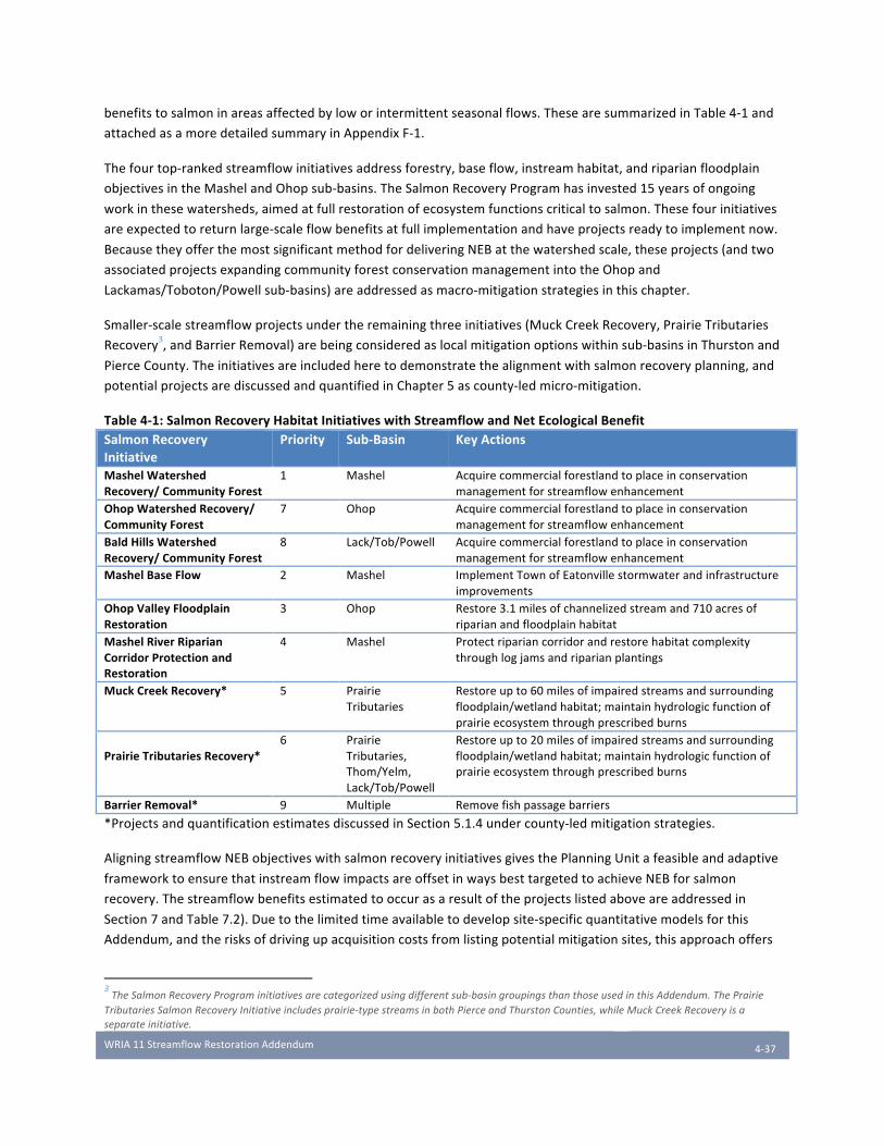
WRIA11StreamflowRestorationAddendum
4-37
benefitstosalmoninareasaffectedbyloworintermittentseasonalflows.ThesearesummarizedinTable4-1and
attachedasamoredetailedsummaryinAppendixF-1.
Thefourtop-rankedstreamflowinitiativesaddressforestry,baseflow,instreamhabitat,andriparianfloodplain
objectivesintheMashelandOhopsub-basins.TheSalmonRecoveryProgramhasinvested15yearsofongoing
workinthesewatersheds,aimedatfullrestorationofecosystemfunctionscriticaltosalmon.Thesefourinitiatives
areexpectedtoreturnlarge-scaleflowbenefitsatfullimplementationandhaveprojectsreadytoimplementnow.
BecausetheyofferthemostsignificantmethodfordeliveringNEBatthewatershedscale,theseprojects(andtwo
associatedprojectsexpandingcommunityforestconservationmanagementintotheOhopand
Lackamas/Toboton/Powellsub-basins)areaddressedasmacro-mitigationstrategiesinthischapter.
Smaller-scalestreamflowprojectsundertheremainingthreeinitiatives(MuckCreekRecovery,PrairieTributaries
Recovery3,andBarrierRemoval)arebeingconsideredaslocalmitigationoptionswithinsub-basinsinThurstonand
PierceCounty.Theinitiativesareincludedheretodemonstratethealignmentwithsalmonrecoveryplanning,and
potentialprojectsarediscussedandquantifiedinChapter5ascounty-ledmicro-mitigation.
Table4-1:SalmonRecoveryHabitatInitiativeswithStreamflowandNetEcologicalBenefitSalmonRecoveryInitiative
Priority Sub-Basin KeyActions
MashelWatershedRecovery/CommunityForest
1 Mashel Acquirecommercialforestlandtoplaceinconservationmanagementforstreamflowenhancement
OhopWatershedRecovery/CommunityForest
7 Ohop Acquirecommercialforestlandtoplaceinconservationmanagementforstreamflowenhancement
BaldHillsWatershedRecovery/CommunityForest
8 Lack/Tob/Powell Acquirecommercialforestlandtoplaceinconservationmanagementforstreamflowenhancement
MashelBaseFlow 2 Mashel ImplementTownofEatonvillestormwaterandinfrastructureimprovements
OhopValleyFloodplainRestoration
3 Ohop Restore3.1milesofchannelizedstreamand710acresofriparianandfloodplainhabitat
MashelRiverRiparianCorridorProtectionandRestoration
4 Mashel Protectripariancorridorandrestorehabitatcomplexitythroughlogjamsandriparianplantings
MuckCreekRecovery* 5 PrairieTributaries
Restoreupto60milesofimpairedstreamsandsurroundingfloodplain/wetlandhabitat;maintainhydrologicfunctionofprairieecosystemthroughprescribedburns
PrairieTributariesRecovery*
6 PrairieTributaries,Thom/Yelm,Lack/Tob/Powell
Restoreupto20milesofimpairedstreamsandsurroundingfloodplain/wetlandhabitat;maintainhydrologicfunctionofprairieecosystemthroughprescribedburns
BarrierRemoval* 9 Multiple Removefishpassagebarriers
*ProjectsandquantificationestimatesdiscussedinSection5.1.4undercounty-ledmitigationstrategies.
AligningstreamflowNEBobjectiveswithsalmonrecoveryinitiativesgivesthePlanningUnitafeasibleandadaptive
frameworktoensurethatinstreamflowimpactsareoffsetinwaysbesttargetedtoachieveNEBforsalmon
recovery.Thestreamflowbenefitsestimatedtooccurasaresultoftheprojectslistedaboveareaddressedin
Section7andTable7.2).Duetothelimitedtimeavailabletodevelopsite-specificquantitativemodelsforthis
Addendum,andtherisksofdrivingupacquisitioncostsfromlistingpotentialmitigationsites,thisapproachoffers
3TheSalmonRecoveryPrograminitiativesarecategorizedusingdifferentsub-basingroupingsthanthoseusedinthisAddendum.ThePrairie
TributariesSalmonRecoveryInitiativeincludesprairie-typestreamsinbothPierceandThurstonCounties,whileMuckCreekRecoveryisa
separateinitiative.

WRIA11StreamflowRestorationAddendum
4-38
amoreconsistentbenchmarkandavoidsthehighdegreeofuncertaintyforanylistofprojectsoveradecades-long
implementationhorizon.TheinitiativesandtemplateprojectsdescribedbelowwillallowEcologyandthe
ImplementingGovernmentstotrackprogresstowardsmaximumNEB,whilepreservingflexibilitytomanage
adaptivelyandactonemergentopportunities.Thisapproachisalsoconsistentwithtypicalsalmonrecovery
projectplanning,inwhichdetailedsite-specificmodelingandprojectdesignsarenotgenerallydevelopedin
advanceofsecuredfundingforimplementation.UsingthesameinitiativeframeworkwillallowGovernmentsto
dovetailfundingrequestsforstreamflowrestorationunderESSB6091withresourcesfromtheSalmonRecovery
FundingBoardandothersources,maximizingthelikelihoodthattheseinitiativescanbefullyimplemented.
Finally,theinitiativeframeworkinformsthePlanningUnit’sprioritizationofprojectsbytakingalong-termviewof
salmonrecoveryandsustainableecologicalbenefits.Whiletheywillprovidesubstantialmitigationforpermit-
exemptwellswithinsub-basins,theprojectsthatfallunderthesemacro-mitigationinitiativesareprioritizedwithin
theWRIAasawhole,targetingbroaderecologicalimpactsbyenhancingflowsandimprovingecologicalprocesses
inupper-watershedbasins,withmoresubstantialbenefitsrealizedonalongertimeframe.ThePlanningUnit’stop
priorityinitiativeinthiscategoryistheMashelWatershedRecovery/CommunityForest.Atfullimplementation,
thisinitiativewillgeneratebetween2and5cfsinaveragelatesummerstreamflowintheMashelRiver,morethan
offsettingtheforecastedactualwaterusefrompermit-exemptwells,usingeithercalculationmethod(seeChapter
3),intheentirewatershed(Halletal.,2018[AppendixG-2]).EDTanalysisalsoranksthisinitiativeasthehighest
priorityoutsideofestuarinerestorationforfurtheringsalmonrecovery(NITSalmonRecoveryProgram,2018).This
initiativerequiresdecadesofmanagingforestlandsforlongerharvestrotationsandstreamflowenhancement,
meaningthattheseeffortsmustbegintodayinordertorealizethosebenefitsassoonaspossible.Likewise,the
processofrestoringthechannel,reconnectingfloodplains,andrebuildingriparianforestsintheOhopsub-basin,
thePlanningUnit’ssecondhighestpriority,hasbeenongoingsince2009andisapproximatelyhalfcompleted(NIT
SalmonRecoveryProgram,2018).
Thislong-rangeandwatershed-widefocusunderliesthePlanningUnit’sdecisiontoprioritizeurgentactionon
CommunityForestacquisitionsintheMashelsub-basinandcontinuedrestorationworkintheOhopValley,where
currentinvestmentswillyieldthegreatestreturninbenefitsforsalmonpopulationsandflowenhancement
throughoutthewatershed.InitiativesdiscussedinChapter5addresssimilarpossibleflowandhabitatrestoration
activitiesintheYelm/Thompson,PrairieTributaries,andLackamas/Toboton/Powellsub-basins,wheregreater
impactsfrompermit-exemptwellsareexpectedtooccur.ThePlanningUnitanticipatesthattheImplementing
Governmentsandotherpartnerswillidentifyactionableprojectsforfurtherrefinementandquantificationwithin
alllistedinitiatives,withongoingcollaborationtoprioritizethosewiththehighestNEBimpacts.
4.1.3 Approach to Quantifying Impacts of Salmon Recovery Initiatives TheSalmonRecoverystrategydefinesquantitativegeospatialmetricsforeachinitiative:shorelinemilesprotected,
feetofditchedchanneltreated,acresoffloodplainconnected,acresofforestlandprotected,etc.(NITSalmon
RecoveryProgram,2018).Existingmodeling,andresultsfrompreviousrestorationwork,reliablydemonstrate
attainablepositivestreamflowimpactsfromimplementingtheseselectedhabitatinitiatives(Halletal,2018;Perry
andJones,2016;Pollocketal,2003).ThePlanningUnithasalsoconductedpreliminarymodelingforstream
restorationinitiativesbasedongroundwaterdatacollectedfollowingditchremovalandfloodplainreconnectionin
theOhopValley(AppendixE).Thismodelisusedasatemplatetoestimatestreamflowbenefitsforanupcoming
shovel-readyOhopprojectdiscussedinthischapter,andisalsoappliedtoestimateflowbenefitsforcounty-led
projectsinsimilarprairie-typestreamsdiscussedinChapter5.
WRIA11StreamflowRestorationAddendum
4-39
ThePlanningUnitexpectstocontinuerefiningquantitativestreamflowbenefitestimatesthroughthe
implementationprocessandadaptivemanagementfollowingAddendumadoption(seeChapter8).Forthose
initiativeswheredetailedlocalstreamflowmodelshavenotyetbeendeveloped,therestorationmetricsinthe
salmonrecoverystrategyprovideabasisforquantifyingNEBresultscorrelatedtorestorationactivities.Salmon
recoveryEDTmetrics,includingaccesstohabitat,presenceoflogjams,habitatdiversity,andwaterquality,are
expectedtoshowquantifiableimprovementasaresultofimplementingtheinitiatives.
4.2 Nisqually Watershed Macro-Mitigations
4.2.1 Community Forest Acquisition for Conservation Management AlignedSalmonRecoveryInitiatives:MashelWatershedRecovery/CommunityForest,OhopWatershed
Recovery/CommunityForest,BaldHillsWatershedRecovery/CommunityForest
FlowRestorationPriority:1(Mashel)
Sub-Basins:Mashel(active),OhopandLackamas/Toboton/Powell(anticipated)
FlowBenefit:2.5-7.5cfs(1,779.5-5,396AFY)NetEcologicalBenefit:Communityforestmanagementwillincreasethequantityandqualityofcriticalsalmon
habitatforESA-listedChinookandsteelhead.
MashelWatershedRecovery/CommunityForestInitiative
TheupperMashelRiverwatershedexperiencedmassiveclear-cutlogginginthefirsthalfofthe20thcentury,andhasbeendamagedbyextensivesedimentloadsfillingpoolsandspawninggravel,reducedwaterretention,elevatedstreamtemperatures,andpoorlarge-woody-debrisrecruitment(NITSalmonRecoveryProgram,2018).Muchoftheupperbasin,particularlytheBusyWildsub-basin,remainsinintensivecommercialforestry,withcontinuednegativeimpactsonstreamflowandhabitat.ProjectstoimplementthisinitiativewillconsistprimarilyofacquiringparcelsofcommercialforestlandintheupperMashelWatershedfortheNisquallyCommunityForest,withamediumtermgoalofowning30,000totalacresofforestlandunderaconservationmanagementregimetomaximizeflowandotherecologicalbenefits.StreamflowenhancementisaprimarygoalofNisquallyCommunityForestmanagement(NisquallyCommunityForest,2016).TheCommunityForestpartnershaveconductedmanagementsimulationsusingtheVisualizingEcosystemLandManagementAssessments(VELMA)ecohydrologicalmodel,whichdynamicallysimulatestheinteractionofhydrologicalandbiogeochemicalprocessesatplot,hillslope,andwatershedscales(seeAppendixG-2,Halletal,2018).BasedonVELMAmodeling,increasingstandagebylengtheningharvestrotationsfrom40yearsto100yearswouldraisebaseflowsintheMashelwatershedbyupto9cfs(Halletal,2018).Todate,justover1,920acresofforestlandintheMashelwatershed(4%ofatotalofapproximately60,000acres)arecurrentlyprotectedandmanagedbytheNisquallyCommunityForest.Approximately22,140acresareownedbytheWashingtonStateDepartmentofNaturalResources,leavingapproximately30,821acres,or57%,currentlyheldascommercialtimberlandspotentiallyavailableforacquisitionandconservationmanagement(JustinHall,NisquallyCommunityForest,personalcommunication,January2019).ForthisAddendum,theVELMAmodelwasusedtoestimatethestreamflowimpactsfromexpandingtheNisquallyCommunityForesttargetingparcelswithanaveragestandageofatleast40years.Themodelindicatesthatthecriticalthresholdforforeststandageforstreamflowbenefitisat40years:younger,fastgrowingtreestakeupgroundwaterathigherrates(onereasonthatregularclearcuttingandreplantingonshortschedulesnegatively

WRIA11StreamflowRestorationAddendum
4-40
impactsstreamflow)(PerryandJones,2016).Conversely,flowbenefitscontinuetocompoundeachyearformaturestandsover40years’averageage.Tworatesofacquisitionwereassumed,describedinTables4-2and4-3below:aminimumscenariobasedontherateofpastacquisitions,andaveryaggressiveratethatassumesacquiringallparcelsoveranaverageof40yearsoldintheMashelandothersub-basins.Theprioritytargetforacquisitionarestandsthatarecurrentlyanaverageofatleast40yearsold,whichwillmaximizetheflowbenefitthatcanberealizedfrompurchasesoverthe20-yearplanninghorizonoftheStreamflowRestorationAct(Halletal,2018andAppendixG-2).However,thePlanningUnitalsoendorsespurchasesofyoungerstandswheneveropportunitiespresentthemselves.ItistheNisquallyIndianTribe’spositionthatacquisitionofanystandforconservationmanagementwillpreventongoingflowlossesfromscheduledclear-cutsandcontinuetoshortentheleadtimetoincreasestandageacrosstheMashelbasin.Themorerapidlyforestlandisacquired,themorerapidlyflowandecologicalbenefitswillaccrue.OhopWatershedandBaldHillsWatershedRecovery/CommunityForestInthelongterm,theCommunityForest’sgoalistoplace70,000-100,000acresofforestlandinconservationmanagement,comprisingalmostallofthecommercialforestlandintheentireNisquallywatershed.PlannedactionsincludeworkingwiththeWashingtonDepartmentofNaturalResourcesregardingmanagementoftheElbeandMineralStateForests(32,600acrestotal),aswellasdirectacquisitionsandsecuringconservationmanagementthroughdeedofrightorotherbindingagreements.Ultimately,thetargetedareaforconservationmanagementincludesapproximately16,402acresintheOhopWatershed,9,393acresintheBaldHillsWatershed,and36,522acresintheUpperNisquallybasin.4Asforestlandsareacquired,additionalprojectsmayalsoincludeactiveforestlandrestorationefforts,includingriparianenhancementstoimprovesalmonspawninghabitat,withpotentialbenefitstostreamflowandstorage.ExpandingtheNisquallyCommunityForest’sholdingstotimberlandsintheOhopandLackamas/Toboton/Powellsub-basinswillhavesimilarsubstantiallong-termbenefitstobaseflowsinthesebasins.WhileafullVELMAmodelhasnotyetbeencreatedforthesesub-basins,ThurstonCountyhasestimatedflowbenefitsforconservationmanagementofforestlandsinthesesub-basinsusingcomparablestandagesbasedontheVELMAmodelfortheMashelwatershed(seeAppendixG-1forfullanalysis).ImplementingthisinitiativewillinvolvefurthermodelingandtargetedpriorityparcelsforacquisitionandmanagementundertheCommunityForest’slongerharvestrotations.Aninitialparcelof240acres(withaveragestandageover80years)inthePowellCreekdrainage,currentlyscheduledforclearcutting,isahighpriorityforacquisitiontoavoidthelossofupto3cfsinstreamflowbyretainingmatureforests.Table4-2and4-3summarizestreamflowbenefitsaccruingoverthenext20yearsofimplementation,assumingaveryconservativeminimumacquisitionscenarioandaverybroadmaximumscenarioofparcelsaveragingatleast40yearsold.Theminimumscenarioassumesratesofacquisitionbasedonpastacquisitions,whichhavebeenconcentratedintheMashel.ThemaximumwascalculatedbasedonassumingtheCommunityForestacquireseveryparcelat40years’averagestandageorolder,includingparcelsintheOhopandLackamas-Toboton-Powellbasins.5Forbothscenarios,therateofpurchasewasassumedtobelinearbeginninginyearone,withflowbenefitsaccruingandcompoundingbasedonthenumberof40+year-oldparcelsinconservationmanagement(seeAppendixG-1).Whileachievingthemaximumscenarioisunlikely,duetouncertaintiesinfundingandopportunitytopurchaseeveryparcelabove40yearsaverageage,itisincludedtorepresenttheupperboundofflowbenefitsattainablethroughforestmanagementintheNisqually’ssubstantialtimberlands.ThePlanningUnitexpectstoupdatebenefitmodelstoreflectactualconditionsasthisplanmovesintoimplementation,and
4AcreagesgivenareapproximatebasedonLandTrendrparceldata,accessedJanuary2019.
5ParcelsintheUpperNisquallysub-basinwerealsoincludedintheanalysisinAppendixG-1,whichalmostdoublesthepotentialacreage.The
UpperNisquallyisnotincludedhereorinthetotalsummaryofmitigationinChapter7(Table7-2andsub-basin-specificsummaries),becauseit
doesnotsupportanadromousfishpopulationsandisinlessneedofmitigationatthistime.
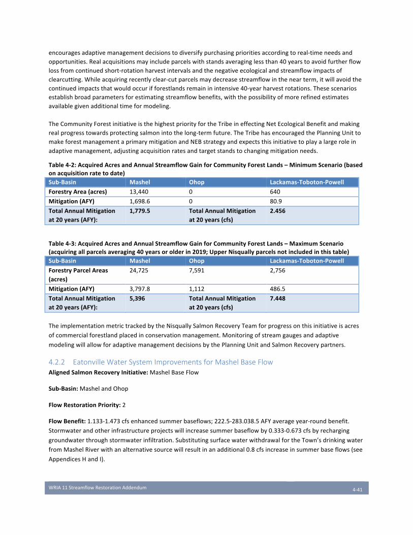
WRIA11StreamflowRestorationAddendum
4-41
encouragesadaptivemanagementdecisionstodiversifypurchasingprioritiesaccordingtoreal-timeneedsandopportunities.Realacquisitionsmayincludeparcelswithstandsaveraginglessthan40yearstoavoidfurtherflowlossfromcontinuedshort-rotationharvestintervalsandthenegativeecologicalandstreamflowimpactsofclearcutting.Whileacquiringrecentlyclear-cutparcelsmaydecreasestreamflowinthenearterm,itwillavoidthecontinuedimpactsthatwouldoccurifforestlandsremaininintensive40-yearharvestrotations.Thesescenariosestablishbroadparametersforestimatingstreamflowbenefits,withthepossibilityofmorerefinedestimatesavailablegivenadditionaltimeformodeling.TheCommunityForestinitiativeisthehighestpriorityfortheTribeineffectingNetEcologicalBenefitandmakingrealprogresstowardsprotectingsalmonintothelong-termfuture.TheTribehasencouragedthePlanningUnittomakeforestmanagementaprimarymitigationandNEBstrategyandexpectsthisinitiativetoplayalargeroleinadaptivemanagement,adjustingacquisitionratesandtargetstandstochangingmitigationneeds.
Table4-2:AcquiredAcresandAnnualStreamflowGainforCommunityForestLands–MinimumScenario(basedonacquisitionratetodate)Sub-Basin Mashel Ohop Lackamas-Toboton-PowellForestryArea(acres) 13,440 0 640
Mitigation(AFY) 1,698.6 0 80.9
TotalAnnualMitigationat20years(AFY):
1,779.5 TotalAnnualMitigationat20years(cfs)
2.456
Table4-3:AcquiredAcresandAnnualStreamflowGainforCommunityForestLands–MaximumScenario(acquiringallparcelsaveraging40yearsorolderin2019;UpperNisquallyparcelsnotincludedinthistable)Sub-Basin Mashel Ohop Lackamas-Toboton-PowellForestryParcelAreas(acres)
24,725 7,591 2,756
Mitigation(AFY) 3,797.8 1,112 486.5
TotalAnnualMitigationat20years(AFY):
5,396 TotalAnnualMitigationat20years(cfs)
7.448
TheimplementationmetrictrackedbytheNisquallySalmonRecoveryTeamforprogressonthisinitiativeisacres
ofcommercialforestlandplacedinconservationmanagement.Monitoringofstreamgaugesandadaptive
modelingwillallowforadaptivemanagementdecisionsbythePlanningUnitandSalmonRecoverypartners.
4.2.2 Eatonville Water System Improvements for Mashel Base Flow AlignedSalmonRecoveryInitiative:MashelBaseFlow
Sub-Basin:MashelandOhop
FlowRestorationPriority:2
FlowBenefit:1.133-1.473cfsenhancedsummerbaseflows;222.5-283.038.5AFYaverageyear-roundbenefit.
Stormwaterandotherinfrastructureprojectswillincreasesummerbaseflowby0.333-0.673cfsbyrecharging
groundwaterthroughstormwaterinfiltration.SubstitutingsurfacewaterwithdrawalfortheTown’sdrinkingwater
fromMashelRiverwithanalternativesourcewillresultinanadditional0.8cfsincreaseinsummerbaseflows(see
AppendicesHandI).
WRIA11StreamflowRestorationAddendum
4-42
NetEcologicalBenefit:ImplementingtheEatonvilleComprehensiveStormwaterPlanwilladdresswaterquality
concernsaswellaslowsummerstreamflowsaffectinglistedandnon-listedsalmonpopulationsintheOhopand
Mashelsub-basins.SomeprojectsmayreduceMashelRiverflowsduringthewintermonthstosupplyadditional
waterforsummermonthswhenbaseflowsarecriticallylow,resultinginoverallecologicalbenefitforsalmon.
ImplementationProjects
StormwaterCapitalImprovementProjectsandConservationEfficienciesTheTownofEatonville,locatedbetweentheMashelRiverandLynchCreekinsouthPierceCounty,producedan
updatedComprehensiveStormwaterPlaninconsultationwiththeNisquallyIndianTribein2013(AHBL,2013).The
Planincludessixcapitalimprovementprojects(CIPs)toaddresswaterqualityanddrainageissuesinEatonville
negativelyaffectingsalmonhabitatintheMashelRiverandOhopCreek,thehighestprioritysalmon-bearing
tributariestotheNisquallyRiver.Currently,mostofEatonville’sstormwaterisdirectedawayfromtheMashel
RiverandsentuntreatedintoOhopCreek,viaLynchCreek.LynchCreekhasbeenlistedbytheDepartmentof
Ecologyforfecalcoliformexceedance,andflaggedbyPierceCountymonitoringforhightotalnitrates,phosphorus,
fecalcoliform,andturbidityandlowdissolvedoxygen(NITSalmonRecoveryProgram,2018).Meanwhile,the
MashelRiverislistedfortemperatureexceedanceinthesummermonths,whencriticallylowflowsandhigh
temperaturesposeadangerforyoungsalmonandimpedeadultmigrationtospawninggrounds.TheseCIPs
includebioretentiontrenches,infiltrationponds,anddrywellstoenablegradualinfiltrationofstormwaterintothe
MashelRiver,improvingwaterqualityinbothsub-basinsandboostingcriticallow-flowperiodsinthesummerby
0.128cfs(38.7AFY).Inaddition,a2012reportidentifiedsignificantlossfromleakagesinEatonville’swatersystem
andWaterTreatmentPlant.ProjectstoimprovewaterconservationinEatonville’ssystemcouldrestoreupto
0.096cfs(69.6AFY)totheMashelRiver.
AquiferStorageandRecoveryEatonvillehasalsoconductedapreliminarystudyofaquiferstorageandrecovery(ASR)tosupplementsummer
wateruse,potentiallyincreasingsummerflowsintheMashelRiverbetween0.11-0.45cfs(Golder,2010).While
aquiferstoragewouldreducewinterflowsintheMashelby0.07-0.25cfs,thenetecologicalbenefitobtainedfor
salmonsurvivalduringthelowflowperiodinthesummermeritsseriousconsideration(seeAppendixH).
AdditionalstudyisneededtoassessthecostandfeasibilityofimplementingASRforNEB.
AlternateWaterSupplyInadditiontocompletingtheComprehensiveStormwaterPlan,thisinitiativeaimstodevelopanalternatewater
supplyfortheTownofEatonvillethatdoesnotderivefromgroundwaterdepletingbaseflowsintheMashelRiver.
TheTown’s400,000gallonperdaydrinkingwatercomesfromtheMashelRiverandfouradjacentgroundwater
wells,whichputsastrainonthebaseflowsoftheriver.Thisisespeciallytrueinsummermonthswhenflowsare
lowduringcriticalspawningandrearingperiodsforlistedsalmonids.AreporttotheTownofEatonvillein2012
estimatedthatrelocatingtheTown’ssurfacewaterdiversiontoAlderLakeortheNisquallyRiverwouldincrease
MashelRiverflowsby0.8cfsduringthelow-flowsummerperiod,withbenefitslikelyexceedingtheimpactsof
withdrawingfromanalternatelocation(RH2,2012).Specificproposalsforanalternatewatersupplyhavenot
beendevelopedatthistime.Table4-4summarizesflowbenefitsfromimplementationoftheseprojects.See
AppendicesHandI(StreamflowMitigationresultingfromtheTownofEatonville’sProjectsandWater
ConservationintheTownofEatonville).
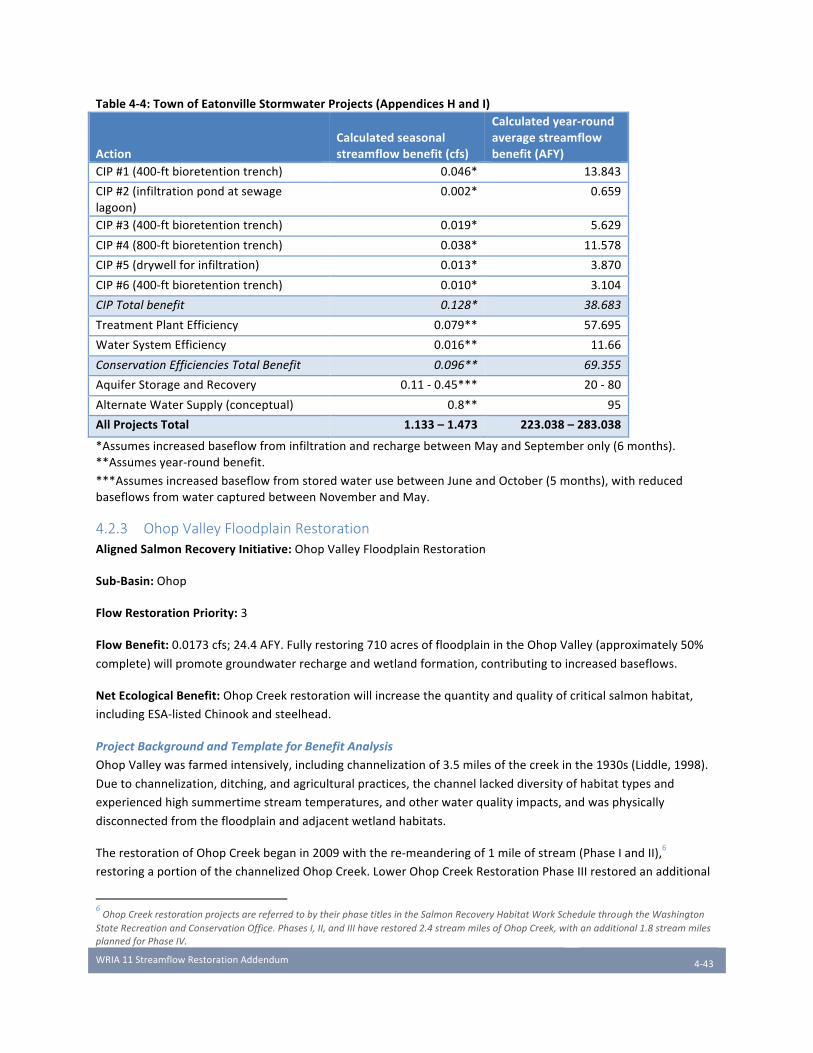
WRIA11StreamflowRestorationAddendum
4-43
Table4-4:TownofEatonvilleStormwaterProjects(AppendicesHandI)
ActionCalculatedseasonalstreamflowbenefit(cfs)
Calculatedyear-roundaveragestreamflowbenefit(AFY)
CIP#1(400-ftbioretentiontrench) 0.046* 13.843
CIP#2(infiltrationpondatsewagelagoon)
0.002* 0.659
CIP#3(400-ftbioretentiontrench) 0.019* 5.629
CIP#4(800-ftbioretentiontrench) 0.038* 11.578
CIP#5(drywellforinfiltration) 0.013* 3.870
CIP#6(400-ftbioretentiontrench) 0.010* 3.104
CIPTotalbenefit 0.128* 38.683
TreatmentPlantEfficiency 0.079** 57.695
WaterSystemEfficiency 0.016** 11.66
ConservationEfficienciesTotalBenefit 0.096** 69.355
AquiferStorageandRecovery 0.11-0.45*** 20-80
AlternateWaterSupply(conceptual) 0.8** 95
AllProjectsTotal 1.133–1.473 223.038–283.038
*AssumesincreasedbaseflowfrominfiltrationandrechargebetweenMayandSeptemberonly(6months).**Assumesyear-roundbenefit.
***AssumesincreasedbaseflowfromstoredwaterusebetweenJuneandOctober(5months),withreducedbaseflowsfromwatercapturedbetweenNovemberandMay.
4.2.3 Ohop Valley Floodplain Restoration AlignedSalmonRecoveryInitiative:OhopValleyFloodplainRestoration
Sub-Basin:Ohop
FlowRestorationPriority:3
FlowBenefit:0.0173cfs;24.4AFY.Fullyrestoring710acresoffloodplainintheOhopValley(approximately50%
complete)willpromotegroundwaterrechargeandwetlandformation,contributingtoincreasedbaseflows.
NetEcologicalBenefit:OhopCreekrestorationwillincreasethequantityandqualityofcriticalsalmonhabitat,
includingESA-listedChinookandsteelhead.
ProjectBackgroundandTemplateforBenefitAnalysis
OhopValleywasfarmedintensively,includingchannelizationof3.5milesofthecreekinthe1930s(Liddle,1998).
Duetochannelization,ditching,andagriculturalpractices,thechannellackeddiversityofhabitattypesand
experiencedhighsummertimestreamtemperatures,andotherwaterqualityimpacts,andwasphysically
disconnectedfromthefloodplainandadjacentwetlandhabitats.
TherestorationofOhopCreekbeganin2009withthere-meanderingof1mileofstream(PhaseIandII),6
restoringaportionofthechannelizedOhopCreek.LowerOhopCreekRestorationPhaseIIIrestoredanadditional
6OhopCreekrestorationprojectsarereferredtobytheirphasetitlesintheSalmonRecoveryHabitatWorkSchedulethroughtheWashington
StateRecreationandConservationOffice.PhasesI,II,andIIIhaverestored2.4streammilesofOhopCreek,withanadditional1.8streammiles
plannedforPhaseIV.
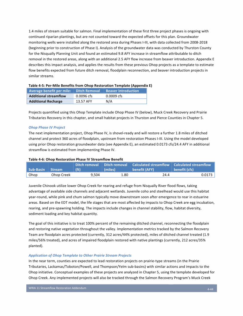
WRIA11StreamflowRestorationAddendum
4-44
1.4milesofstreamsuitableforsalmon.Finalimplementationofthesefirstthreeprojectphasesisongoingwith
continuedriparianplantings,butarenotcountedtowardtheexpectedoffsetsforthisplan.Groundwater
monitoringwellswereinstalledalongtherestoredareaduringPhasesI-III,withdatacollectedfrom2008-2018
(beginningpriortoconstructionofPhaseI).AnalysisofthegroundwaterdatawasconductedbyThurstonCounty
fortheNisquallyPlanningUnitandfoundanestimated9.8AFYincreaseinstreamflowattributabletoditch
removalintherestoredareas,alongwithanadditional2.5AFYflowincreasefrombeaverintroduction.AppendixE
describesthisimpactanalysis,andappliestheresultsfromthesepreviousOhopprojectsasatemplatetoestimate
flowbenefitsexpectedfromfutureditchremoval,floodplainreconnection,andbeaverintroductionprojectsin
similarstreams.
Table4-5:Per-MileBenefitsfromOhopRestorationTemplate(AppendixE)Averagebenefitpermile: DitchRemoval BeaverIntroductionAdditionalstreamflow 0.0096cfs 0.0009cfsAdditionalRecharge 13.57AFY N/A
ProjectsquantifiedusingthisOhopTemplateincludeOhopPhaseIV(below),MuckCreekRecoveryandPrairie
TributariesRecoveryinthischapter,andsmallhabitatprojectsinThurstonandPierceCountiesinChapter5.
OhopPhaseIVProject
Thenextimplementationproject,OhopPhaseIV,isshovel-readyandwillrestoreafurther1.8milesofditched
channelandprotect360acresoffloodplain,upstreamfromrestorationPhasesI-III.Usingthemodeldeveloped
usingpriorOhoprestorationgroundwaterdata(seeAppendixE),anestimated0.0173cfs/24.4AFYinadditional
streamflowisestimatedfromimplementingPhaseIV.
Table4-6:OhopRestorationPhaseIVStreamflowBenefit
Sub-Basin StreamDitchremoval(ft)
Ditchremoval(miles)
Calculatedstreamflowbenefit(AFY)
Calculatedstreamflowbenefit(cfs)
Ohop OhopCreek 9,504 1.80 24.4 0.0173
JuvenileChinookutilizelowerOhopCreekforrearingandrefugefromNisquallyRiverfloodflows,taking
advantageofavailablesidechannelsandadjacentwetlands.Juvenilecohoandsteelheadwouldusethishabitat
year-round,whilepinkandchumsalmontypicallymovedownstreamsoonafteremergencetorearinestuarine
areas.BasedontheEDTmodel,thelifestagesthataremostaffectedbyimpactstoOhopCreekareeggincubation,
rearing,andpre-spawningholding.Theimpactsincludechangesinchannelstability,flow,habitatdiversity,
sedimentloadingandkeyhabitatquantity.
Thegoalofthisinitiativeistotreat100%percentoftheremainingditchedchannel,reconnectingthefloodplain
andrestoringnativevegetationthroughoutthevalley.ImplementationmetricstrackedbytheSalmonRecovery
Teamarefloodplainacresprotected(currently,312acres/44%protected),milesofditchedchanneltreated(1.9
miles/56%treated),andacresofimpairedfloodplainrestoredwithnativeplantings(currently,212acres/35%
planted).
ApplicationofOhopTemplatetoOtherPrairieStreamProjects
Inthenearterm,countiesareexpectedtoleadrestorationprojectsonprairie-typestreams(inthePrairie
Tributaries,Lackamas/Toboton/Powell,andThompson/Yelmsub-basins)withsimilaractionsandimpactstothe
Ohopinitiative.ConceptualexamplesoftheseprojectsareanalyzedinChapter5,usingthetemplatedevelopedfor
OhopCreek.AnyimplementedprojectswillalsobetrackedthroughtheSalmonRecoveryProgram’sMuckCreek
WRIA11StreamflowRestorationAddendum
4-45
RecoveryandPrairieTributariesRecoveryinitiatives,usingmetricsincludingshorelinemilesandfloodplainacres
protectedandrestored(NITSalmonRecoveryProgram,2018).
Anadditionalactionrecommendedinthesalmonrecoverystrategyforintermittentorlow-flowprairiesystemsis
maintenanceofprairieecosystemconditionsthroughregularprescribedburns.Researchonthecolonizationof
PugetSoundprairiesbyDouglasfirs,resultingfromdecreaseinthefrequencyoffiresanddisruptionofnatural
prairieecosystems,indicatesthatyoungfirtreesdrawuplargequantitiesofwaterotherwiseavailablefor
instreamflows(PeterandHarrington,2014).Maintainingprairiehabitatthroughprescribedburnsandother
managementstrategiesisalsorecommendedasamethodtomaintainandenhanceflowsinthesebasins.While
notaddressedasaquantitativestrategyinthisAddendum,thePlanningUnitencouragesmonitoringof
prairielandsandpossiblemaintenancestrategiesthroughadaptivemanagement.
4.2.4 Mashel River In-Stream Habitat Improvement Projects AlignedSalmonRecoveryInitiative:MashelRiverRiparianCorridorProtectionandRestoration
Sub-Basin:Mashel
FlowRestorationPriority:4
FlowBenefit:Notyetquantified.In-channelstorageandincreasedinfiltrationopportunitiesfromconstructionof
EngineeredLogJams(ELJs)arelikelytoprovidesmallflowincreases.
NetEcologicalBenefit:ELJswillcreateincreasedpoolhabitat,providingpreferredspawningareasforESA-listedsalmon,habitatcomplexity,andincreasedchannelvolumeduringlowsummerflowperiodscriticalforjuvenile
salmon.
ProjectBackgroundandTemplateforBenefitAnalysis
LoggingactivitiesintheMashelsub-basinhavesignificantlyimpactedthehabitatqualityandinstreamflow
patternsintheMashelRiver.Extensivetimberharvestingoverthelast100yearshasgreatlydecreasedtheinputof
largewoodintotheMashelBasin.Thereachdesignatedfortreatmentinthisinitiativehaslost50%ofitspool
habitat.Inaddition,destabilizingslopesandincreasingerosioncontributetohighlevelsofsedimentationand
flashyflowpatterns,bothdetrimentaltoChinooksalmonandsteelhead(WatershedProfessionalsNetwork,2004).
Since2006,watershedpartnershaveinstalled52ELJsintheMashelRiver,accompaniedbyriparianplantingsto
improvechannelstabilityandcomplexity.Atotalof75ELJsareplannedfortheMashelRiverbytheSalmon
RecoveryTeam(MashelEatonvilleRestorationProjectPhaseIII,2015).Long-termstreamflowimpactsfromELJs
havenotbeenthoroughlystudied,butincreasingpoolhabitatwillalsoincreasechannelvolume,promoting
groundwaterinfiltration,andprovidecriticaldeeperhabitatforjuvenileChinookandsteelheadduringsummer
periodsoflowbaseflows(Pollocketal,2015;Beechieetal,2010).
Importantly,monitoringoftheinstalledELJsintheMashelRiverhasrevealedthattheyarenotrecruitingnew
woodasquicklyaspredicted,meaningtheyarenotyetself-sustainingwithnaturalecosystemresourcesand
requireongoingmaintenance.Untilprotectionofupstreamhabitatcanbeguaranteedandforestsaregiventhe
opportunitytomature,therewillbeaconstantneedtointroducewoodintothesystem.Thisinitiativeworksin
concertwiththeMashelWatershedRecovery/CommunityForestInitiative(Section4.2.1),providingimmediate
criticalhabitatbenefitsforlistedsalmonpopulationsthatwillrequirelesscontinuedmaintenanceasupper
watershedforestsmatureandbeginsupplyingnaturalwoodydebrisinlargerquantities.

WRIA11StreamflowRestorationAddendum
4-46
Groundwaterandinstreamflowmonitoringmaybeimplementedalongwithfutureprojectstoquantifythe
streamflowimpactofELJsintheMashelRiver.ThemainmetricforinitiativeimplementationisthenumberofELJs
inplaceandfunctionalintheMashelRiver(currently52outof75planned).Inaddition,theSalmonRecovery
TeamtracksmilesofshorelineandacresoffloodplainunderprotectioninthelowerreachesoftheMashel
WRIA11StreamflowRestorationAddendum
5-47
Chapter 5 Mitigation Strategies in the Nisqually
Watershed
MitigationstrategiesandrecommendationsinthisplanAddendumfollowthe“actualconsumptive”versus“legal
consumptive”distinction,adistinctionwearetermingmicroandmacro.Themacro-mitigationapproachdiscussed
inChapter4involveslarge-scaleinitiativestoprovidemitigationandNetEcologicalBenefitwithinexistingsalmon
recoverystrategies.Themicro-mitigationstrategiesoutlinedinthischapterprovideapproachestomitigating
withinsub-basinsasneededtooffsetpermit-exemptwelluse.Atleastsomeofthesestrategiesaresitespecific
andallaresub-basinspecific.Themicro-mitigationstrategiesdiscussedbelowwillrequirefurtherworktoanalyze
benefitsanddevelopimplementationstrategiesatthecountyormunicipallevel.Thequantityofmitigation
necessaryunderthemicro-mitigationstrategywillalsodependuponfurtheranalysisofecologicalbenefitsthatare
realizedasmacro-mitigationprojectsarefundedandimplemented.
5.1 Specific Micro-Mitigation Strategies Thesameglacialgeologythatresultsinhydrauliccontinuitybetweenshallowgroundwaterandstreamflow(and
explicitmitigationneed)alsoprovidespotentialmitigationoptionsthat,eitheraloneorintandem,wouldmitigate
someimpactsofwellwithdrawalsonstreamflow.Someoftheoptionsdiscussedbelowcouldactuallybenefit
streamflowinsub-basinsinthewesternpartofthewatershedbecausewithdrawalofgroundwaterfromdeeper
aquifersystemswillintroducemoresurfaceflowbeyondsimplymitigatingforthewellwithdrawal.
5.1.1 Mitigation Approach in Prairie Environments Throughoutsub-basinscharacterizedbyprairiestreams(Thompson/Yelm,Lackamas/Toboton/Powell,andPrairie
Tributariessub-basins),thereareseveralaquifers,eachsomewhatconfinedandeachdeeperthanthenext(Figure
3).Theuppermostwaterbearingunit,Qvr,isunconfinedandinteractswiththestreamflowsoftheprairie
tributaries.UnderlyingQvrisaconfininglayerofglacialtillandbelowthat,anaquiferreferredtoasQva.Adeeper
aquifer,Qc,(referredtoastheSeaLevelaquifer)underliestheprairiesatanevengreaterdepthandbeneaththat,
theUndifferentiateddepositsreferredtoasTQu.TheQcandTQuarebelowsealevelanddischargetothePuget
Sound.Becausetheyaremajorsourcesofdrinkingwater,thedeeperaquifershavebeenwellstudied.Figure3
presentsacrosssectionfromDrostet.al.,1999thatillustratestheaquiferlayersunderlyingprairieareasof
ThurstonCounty.AsimilaraquifersystemunderliesthePierceCountyaquifers.
Thus,iffuturewellsarefinishedindeeperaquifers,theynotonlyavoidthedirectimpacttotheunconfined
outwashdepositsoftheupperaquifersandassociatedtributaries,butactuallymaycontributewatertothe
uppermostwaterbearingunits.ThisplanAddendumproposesseveralapproachestoaccomplishingmitigationby
drawingwaterfromthedeeperaquifers.Theseapproachesarequantifiedonaper-wellbasis,ratherthanawater
usequantification,witheverynewindividualpermit-exemptwellinashallowaquiferbeingoffsetbyremovingan
existingpermit-exemptwellfromshallowaquiferwithdrawalsorbyfinishingthenewpermit-exemptwellina
deeperaquifer.Itshouldbenotedthatthisproposedmethodofmitigationdependsonafeasibilitystudyto
ensurethatspecificwellwithdrawalsindeepersystemswillhaveadequatewaterqualityandquantity.
ThePlanningUnit’srationaleforthisper-wellquantificationapproachisasfollows:UsingEcologyguidance,each
newpermit-exemptwellthatisfinishedintheupperorunconfinedaquifermaybeassumedtoremoveanaverage
WRIA11StreamflowRestorationAddendum
5-48
of382gpdfromthataquiferandreturn159netgallons(non-consumptiveportionofthedomesticuse),resulting
inanetuse,andthusmitigationneed,of223gpd/0.249AFYperconnection(seeChapter3fordetailed
discussion).WateruseestimatesusingThurstonPUDdatacouldalsobeusedinthisexample).Finishingthatsame
exemptwellinadeeperaquiferresultsintheremovalofthesame382gallons,butfromadeeperaquiferthatis
otherwisedischargingtoPugetSound.Givenmodelingdonetodateontheaquifersunderlyingtheprairieareasof
theNisquallywatershed,itisreasonabletoconcludethatnotonlyistheuseofwater(223gpd)fullymitigated,but
thatsomeportionofthereturnwater(159gal/day)willberetainedintheupperaquiferandprovideanetbenefit
tostreamflows(CityofOlympiaandNisquallyIndianTribe,2008).ForpurposesofthisAddendum,theNisqually
PlanningUnitproposesthateverypermit-exemptwellremovedfromtheshallowaquiferprovidesa223gpd
mitigationoffset.Althoughthereislikelyanadditionalstreamflowbenefitfromutilizinggroundwaterfromdeeper
systems,thePlanningUnitisnotproposingthatbenefitbecountedasoffset.
ThisapproachissupportedbydatadevelopedforYelm’swaterrightsapplicationandsystemexpansion(discussed
below)andresearchconductedbytheUSGSfortheKitsapPeninsula,anareawithmultiplehydrogeologicunits
similartothosefoundinthelower(glaciated)portionoftheNisquallyWatershed(FransandOlsen,2016).In
summary,thisUSGSmodelingeffortdeterminedthatmovingwellwithdrawaltoadeeperaquiferresultedinanet
gaintotheupperaquiferandstreamflows.
DeepGroundwaterOption1–Finishnewpermit-exemptwellsindeeperaquifer
Ifcountieschoosetopursuethisoption,anindividualpermit-exemptwellproponentwhofinishesanewwellinaloweraquifercouldbecreditedforoffsettingalargeportionoftheprojectedconsumptiveuseforthatconnection,dependingonlocationanddepth.Enforcementofthecommitmentmaybeaccomplishedthroughpermittingreviewcoordinatedbythecountyissuingthebuildingpermitandthecertifyinggovernmentofthewelldrillingrecord(seeChapter6formoredetaileddescriptionofthisprocess).Enforcementandotherspecificsofthatpermittingprocessaretobedeterminedbythecountyinimplementationthroughitsownrequiredpublicprocess.
DeepGroundwaterOption2–Retireexistingpermit-exemptwellsfromupperaquifer
Anothermitigationopportunityistoretirewellsthatcurrentlydrawfromthesurfaceaquiferincontinuitywith
localstreams.Thesimplestapproachisretiringanexistingpermit-exemptwellwhenthewellownerhas
opportunitytoconnecttoaGroupAorBsystem.Theretirementofoneexistingwellwouldconstitutemitigation
creditforonenewpermit-exemptwellinthesamesub-basin.Thismitigationstrategywouldbeespecially
effectiveintheThompson/Yelmsub-basin,andisexplainedbelowinthediscussionoftheCityofYelm’swater
rightapplication.
DeepGroundwaterOption3–DeepenorupgradeGroupAsystemstooffsetindividualpermit-exemptwells
AnotherapproachrecommendedbythePlanningUnitistoworkwithexistingGroupAwatersystemstoinvestin
systemupgrades,suchasadeeperwellormoreefficientconveyanceinfrastructure,expandtomoreconnections,
orotherdesignupgradesorstrategiestoreduceandoffsetimpactstostreamflows.Investmentinsmallwater
systemsfirstrequiresinvestigationtodeterminefeasibilityofcompletingoneormorenewGroupAwellsina
deeperaquifer.InitialinquirysuggeststhatthisapproachmightbeofinterestforoneormoreoftheGroupA
systems,especiallyonesthatarecurrentlyexperiencingwatersystemissues.Atechnicalfeasibilitystudyforeach
system,includinganalysisofmitigation,iscurrentlybeyondthefinancialcapabilityofanindividualGroupAsystem
andthereforesometypeofgrantorloanprogramwilllikelybeneededforinvestigationandimplementation.The
PlanningUnitrecommendsthattheImplementingGovernmentsworkwiththeThurstonPUDandotherentitiesas
appropriatetoinvestigatethefeasibilityofthisapproach,includingexploringgrantorloanprogramstosupport
systemimprovements(implementationisaddressedinChapter8).Iffeasible,thisapproachwouldoffermitigation
offsetsformultiplenewpermit-exemptwells.

WRIA11StreamflowRestorationAddendum
5-49
AvariationofthisoptioninvolvesoldersystemsandwouldtargetsmallerpublicwatersystemsinThurstonCounty
establishedpriortoMay1,1994thatareconsideredprovisionallyadequate,butdonotmeetthecurrentdesign
standardsoftheThurstonCountySanitaryCode(ArticleIII),WAC246-290orWAC246-291.Thistypeofprogram
couldalsobemadeavailabletootherwatersystemsthatcouldbenefitfromefficiencyupgradesandcouldbe
funded,inpart,bythefeescollectedthroughthepermittingstrategydescribedinSection6.1.Upgradingthese
antiquatedsystemswouldnotonlyprovidepossiblemitigationcreditstooffsettheimpactsofnewpermit-exempt
wellsbutcouldalsobenefittheusersoftheseoldersystemsbyimprovingwaterqualityandreliability.
TheThurstonPUDhasidentifiedthreeGroupAwatersystemsthatcouldbecandidatesforpotentialinfrastructure
improvements(oneinPierceCountyinthePrairieTributariessub-basin,oneinThurstonCountyinthe
Thompson/Yelmsub-basin,andoneinThurstonCountyintheuppermostpartofLackamas/Toboton/Powellsub-
basin).Combined,thethreesystemscurrentlyhave45activeconnectionsoutof84authorizedconnections.
However,priortodrilling,thePUDrequiresinitialfundingassistanceforahydrogeologicassessmenttodetermine
theprobabilitythatthewaterwouldbeavailableinsufficientqualityandquantityindeeperaquifers,andtoassess
impactsonstreamflow.ThePUDisrequestingfundingbeavailabletoconductthehydrogeologicalanalysispriorto
commencementofanydrillingactivities.AletterfromtheThurstonPUDprovidingdetailsregardingthethree
watersystemsisincludedasAppendixJ.
Drillingtoadeeperaquiferwouldresultinachangeinthe“watersource”associatedwiththeexistingGroupA
waterright.Therefore,iffoundtobetechnicallyfeasibleforasmallGroupAsystem,implementingthisaction
wouldrequireamodificationtotheGroupA’sexistingwaterrightoranewwaterright,supportedbystudiesto
evaluatetheimpactsofthesechanges.
ExamplesofDeepGroundwaterOffsets
TheCityofYelmcurrentlyprovidesdrinkingwaterwithinitsservicearea,whichincludesYelm’sUrbanGrowth
Area(UGA),fromtheshallowVashonAdvance(Qva)aquifer.Withalimitednumberofnewconnectionsavailable
withoutadditionalwaterrights,itisYelm’spolicytoreserveitsexistingwaterconnectionstoservevacant
propertieswithinthecurrentcitylimits.Consequently,mostnewresidentialdevelopmentintheYelmUGArelies
onpermit-exemptwells(70%,asdetailedinthewaterforecastChapter3).
Yelmisintheprocessofapplyingforwaterrights(underWaterRightControlNumberG2-29085)thatwould
supportanewwelldrilleddeepinthelower(TQu)aquifer.TheYelmwaterrightisawaterresourcemitigation
pilotprojectidentifiedinRCW90.94.090,andwillbeprocessedunderthispilotprojectauthority.Ifapproved,
Yelm’scapacitytoprovidewaterservicewouldincrease950AFY,fromaround700AFYto1650AFY.Thissingle
actionwouldprovidemultiplepotentialbenefitstostreamflowintheNisquallyWatershed:
1. ConnectingnewdevelopmenttoCityWaterServicethatotherwisewouldhavereliedonapermit-exemptwell–shiftingthewaterusefromtheshallowaquifertothedeeperaquifer.ThissingleactionreducestheprojectedconsumptiveusefortheentireThompson/Yelmsub-basinby62%.
2. Connectingexistingdevelopmentonapermit-exemptwellwithintheUGAandCityboundarytoCityWaterService–shiftingwaterusefromtheshallowaquifertothedeeperaquifer.
3. Enablingreclaimedwaterthatinfiltratesintotheshallowaquifer–currentlyusedtomitigateforimpactsoftheshallowwell–tooffsetimpactstotheshallowaquiferofpermit-exemptwells.
Thebenefitsthateachoftheseactionsprovidearefurtherdescribedbelow.ThePlanningUnitstronglysupports
approvalofYelm’swaterrightapplicationsubsequenttomeetingfullmitigationrequirements.
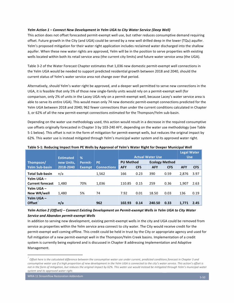
WRIA11StreamflowRestorationAddendum
5-50
YelmAction1–ConnectNewDevelopmentinYelmUGAtoCityWaterService(DeepWell)
Thisactiondoesnotoffsetforecastedpermit-exemptwelluse,butratherreducesconsumptivedemandrequiring
offset.FuturegrowthintheCity(andUGA)couldbeservedbyanewwelldrilleddeepinthelower(TQu)aquifer.
Yelm’sproposedmitigationfortheirwaterrightapplicationincludesreclaimedwaterdischargedintotheshallow
aquifer.Whenthesenewwaterrightsareapproved,Yelmwillbeinthepositiontoservepropertieswithexisting
wellslocatedwithinbothitsretailservicearea(thecurrentcitylimits)andfuturewaterservicearea(theUGA).
Table3-2oftheWaterForecastChapterestimatesthat1,036newdomesticpermit-exemptwellconnectionsin
theYelmUGAwouldbeneededtosupportpredictedresidentialgrowthbetween2018and2040,shouldthe
currentstatusofYelm’swaterserviceareanotchangeoverthatperiod.
Alternatively,shouldYelm’swaterrightbeapproved,andadeeperwellpermittedtoservenewconnectionsinthe
UGA,itisfeasiblethatonly5%ofthosenewsingle-familyunitswouldrelyonapermit-exemptwell(for
comparison,only2%ofunitsintheLaceyUGArelyonapermit-exemptwell,becauseLacey’swaterserviceareais
abletoserveitsentireUGA).Thiswouldmeanonly74newdomesticpermit-exemptconnectionspredictedforthe
YelmUGAbetween2018and2040;962fewerconnectionsthanunderthecurrentconditionscalculatedinChapter
3,or62%ofallthenewpermit-exemptconnectionsestimatedfortheThompson/Yelmsub-basin.
Dependingonthewaterusemethodologyused,thisactionwouldresultinadecreaseintherequiredconsumptive
useoffsetsoriginallyforecastedinChapter3by103-240AFY,dependingonthewaterusemethodology(seeTable
5-1below).Thisoffsetisnotintheformofmitigationforpermit-exemptwells,butreducestheoriginalimpactby
62%.ThiswateruseisinsteadmitigatedthroughYelm’smunicipalwatersystemanditsapprovedwaterright.
Table5-1:ReducingImpactfromPEWellsbyApprovalofYelm’sWaterRightforDeeperMunicipalWell
Thompson/YelmSub-basin
EstimatednewUnits,2018-2040
%Permit-Exempt
PEConnections
ActualWaterUseLegalWater
UsePUMethod EcologyMethod AFY CFS AFY CFS AFY CFS
TotalSub-basin n/a 1,562 166 0.23 390 0.59 2,876 3.97YelmUGA–Currentforecast 1,480 70% 1,036 110.85 0.15 259 0.36 1,907 2.63YelmUGA–NewWR/well 1,480 5% 74 7.92 0.01 18.50 0.03 136 0.19YelmUGA–Offset7 n/a 962 102.93 0.14 240.50 0.33 1,771 2.45
YelmAction2(Offset)–ConnectExistingDevelopmentonPermit-exemptWellsinYelmUGAtoCityWater
ServiceandAbandonpermit-exemptWells
Inadditiontoservingnewdevelopment,existingpermit-exemptwellsinthecityandUGAcouldberemovedfrom
serviceaspropertieswithintheYelmserviceareaconnecttocitywater.TheCitywouldreceivecreditforthe
permit-exemptwellcomingoffline.ThiscreditcouldbeheldintrustbytheCityorappropriateagencyandusedfor
fullmitigationofanewpermit-exemptwellintheThompson/YelmCreekbasins.Implementationofacredit
systemiscurrentlybeingexploredandisdiscussedinChapter8addressingImplementationandAdaptive
Management.
7Offsethereisthecalculateddifferencebetweentheconsumptivewateruseundercurrent,predictedconditionsforecastinChapter3and
consumptivewateruseifahighproportionofnewdevelopmentintheYelmUGAisconnectedtothecity’swaterservice.Thisaction’soffsetis
notintheformofmitigation,butreducestheoriginalimpactby62%.ThiswaterusewouldinsteadbemitigatedthroughYelm’smunicipalwater
systemanditsapprovedwaterright.

WRIA11StreamflowRestorationAddendum
5-51
ThurstonCountyestimatestherearecurrentlyapproximately450domesticconnectionstopermit-exemptwellsin
theYelmUGA.Transferfromexistingpermit-exemptwellstoCitywaterservicewithintheUGAwouldbe
voluntary.ThenumberofexistingconnectionsthatcouldbetransferredtotheYelmmunicipalwaterservice
withintheplanningperiodwilldependonmanyfactors,includingtheconstructionofwaterinfrastructurein
relationtothelocationofexistingdevelopmentandincentivestopropertyowners.Foreverypermit-exemptwell
connectionreplacedbyCityservice,therewillbeamitigationoffsetof223gpd(0.249AFY)(Ecology
methodology).Aconservativeestimateisthat10%ofexistingconnectionswouldbeconvertedinthe22-year
planningperiod–ifusedtomitigate42newpermit-exemptwellsintheruralareasoftheThompson/Yelmsub-
basin,thisactionwouldresultinanoffsetof4.4-10AFY,dependingonthemethodologyusedtocalculatewater
use(seeTable5-2below).
Table5-2:WaterUseOffsetbyExistingPermit-ExemptWellsinYelmUGAConnectedtoExpandedYelmWaterService
YelmUGAEst.existingPermit-exemptconnections
%ConnectedtoYelmwaterservice
PEConnectionsOffset
ActualWaterUseOffset LegalWaterUse
PUMethod EcologyMethod
AFY CFS AFY CFS AFY CFS
415 10% 42 4.44 0.0061 10.38 0.014 76.4 0.11
YelmAction3(Offset)–UseaPortionoftheCity’sInfiltratedReclaimedClassAWastewaterasMitigation
TheCityofYelmisintheprocessofexpandingitsabilitytore-usehighly-treatedwastewaterasClassAreclaimed
water.AppendixLdescribesthecurrentunderstandingofClassAReclaimedWateravailability.Reclaimedwater
infiltratedtoavoidimpactstoYelmCreekasidentifiedinYelm’swaterrightsmitigationplanwouldnotbeeligible
tooffsetimpactsofpermit-exemptwells,asitwillberequiredtooffsetimpactsfrompumpingthewaterinthe
firstplace.TheCityanticipatesinitsconceptualwaterrightsmitigationplantheneedtoinfiltrateupto70acre
feetinordertomitigateimpactstoYelmCreekfrompumping942acrefeetfromthedeepaquifer.However,
additionalreclaimedwaterinfiltratedabovethisrequirementcouldpotentiallybeusedasanoffsetforwateruse
frompermit-exemptwellsintheThompson/Yelmsub-basin.
In2016,Yelmpumpedatotalgroundwatervolumeof714AF(DOHSentrydatabaseWaterUseEfficiencyReport
for2016).CityofYelmrecordsreportatotalreclaimedwaterre-usein2016of406AF.Thismeansthatupto57%
ofYelm’stotalgroundwaterpumpedwaseventuallyreclaimed.
Accordingto2016totals,thisreclaimedwateris:
• Soldforirrigatingparksandplayfields:71AFin2016
• RechargedintotheQva(Vashonadvance)aquifer,slightlyupgradientfromthepointofwithdrawalatCochranePark:62AFin2016
• DischargedtotheCentraliaPowerCanal(primarypointofdischarge)ortheNisquallyRiver(secondarypoint):273AFin2016
• TotalClassAReclaimedwaterusedin2016:406AF
OncetheCityobtainsadditionalwaterrightsandplacesitsdeeperwellinproduction,thisinfiltratedreclaimed
watercouldprovideadirectnetbenefittotheshallowaquiferthatmostaffectsstreamflowinthewatershed.
Assumingtheproportionofwaterreclaimedremainsthesame,theamountofannualreclaimedwateravailable
forusewouldincreaseto537AFY–57%ofthenewwellpumpingrateof942AFY.Ofthis,70AFYwillbeneeded
asmitigationforthenew,deeperwell.Thisleaves466AFY.Table5-3belowcalculatesthepotentialoffsetofthis

WRIA11StreamflowRestorationAddendum
5-52
reclaimedwaterforpermit-exemptwells,usingthesameproportionsofusesfrom2016.Theportionofreclaimed
waterusedforirrigationwouldbereducedbyan80%consumptionfactorduetoevapotranspiration.Itshouldbe
notedthat,underthenewpumpingscenario,313AFYoftheestimatedstreamflowbenefitisdischargeddirectlyto
theNisquallyRiverandCentraliaPowerCanalatthedownstreamendofthesub-basin(seeassumption5below).
71AFYisinfiltratedtogroundwaterand16AFYfromirrigationrechargesgroundwater(totalof87AFYoflocal
recharge)inthevicinityoftheYelmCreekandwillhavemoredirectbenefittotributaryflow.
Table5-3:PotentialMitigationBenefitofYelm’sReclaimedWaterProgramtoShallowAquifer
ReclaimedWaterUse
%ofTotalReclaimedWaterUse8
CURRENTWELLNewWaterRight(DeepAquifer)
AFYStreamflowBenefit9(AFY) AFY
StreamflowBenefit(AFY)
Irrigationofparksandplayfields 17% 71 14 81 16
DirectrechargetoQva(inYelm) 15% 62 62 71 71
Dischargedtocanal/river 67% 273 273 313.5 313.5TOTAL 100% 406 349 466 401
Thispotentialoffsetiscalculatedwiththefollowingassumptions:
• Assumption#1:100%mitigationwillberequiredfortheCityofYelm’sexpandedwaterright.DepartmentofEcologywaterrightspermitnegotiationsfortheexpansionoftheCityofYelm’swaterrightpermits(theso-called‘YelmPilotProject’)outcomewillresultina‘100%mitigation’requirementoftheCityofYelm’spumpedgroundwater.Yelmanticipatesthisneedtobeapproximately70acrefeetperyear.
• Assumption#2:TheCityofYelm’sproportionofClassAreclaimedwaterremainsthesame.Datafor2016indicatethatapproximately57%ofYelm’scurrentpumpedwaterreturnsaswastewater.Thisisbasedonatotalpumpedgroundwatervolumeof714AFfor2016(DOHSentrydatabaseWaterUseEfficiencyReportfor2016)andatotalreclaimedwaterre-useof406AFin2016fromCityofYelmrecordsnotedabove.
• Assumption#3:Engineering,permitting,costandotherfeasibilityquestionscanestablishameansforexpandinguseofthiswaterformitigation.Significantlyexpandedaquiferrechargewouldberequired,withunansweredquestionsregardingitsfeasibility.
• Assumption#4:Current(2016)Class-AReclaimedWaterproductionisanindicatoroffutureavailabilityandproportionsofuse.
• Assumption#5:ReclaimedwaterdischargedtotheCentraliaPowerCanalortotheNisquallyRiverbenefitsstreamflows.MinimummitigationestimatesforYelmAction3(offset)assumesthatthereclaimedwaterdischargedtotheNisquallyRiverandCentraliaPowerCanaldoesnotqualifyasmitigation,maximummitigationestimatesassumethatthiswaterdoesqualifyasanoffsetfortheThompson/Yelmsub-basin(seeTable7-2).
• Alternatively,theCityofYelmcouldceaseusingreclaimedwaterforirrigationandsurfacedischarge.Underthisalternative,all466AFYofreclaimedwatercouldbeusedforoffsettingpermit-exemptwells’consumption.
8BasedonCityofYelmreportof2016wateruse.
9Rechargedtotheaquiferordischargeddirectly(notevaporatedthroughoutdoorirrigation)

WRIA11StreamflowRestorationAddendum
5-53
Despitetheseassumptions,thereisstrongpotentialfortheCityofYelm’sClassAreclaimedwatertoforma
significantpartofthemitigationrequirementforpermit-exemptwellsintheThompson/Yelmsub-basin.Irrigation
andotherusesofreclaimedwaterclaimedforstreamflowbenefitapplyonlywithinYelmcitylimits.Thurston
County’sCriticalAreasOrdinancecurrentlydoesnotpermitlarge-scaleinfiltrationofreclaimedwater(definedas
“applicationtotheland'ssurfaceaboveagronomicrates”)(TCC24.10.190),untiladditionalinformationfromthe
RegionalGroundwaterRechargeScientificStudyandothersourcescanbeconsidered.ThurstonCountycould
reconsiderthislimitationinlightofinformationthatmayhavecomeavailablesincetheadoptionofthatpolicy,in
ordertoincreaseoptionsformitigatingstreamflowsinunincorporatedThurstonCounty.Anyproposedchangesto
ThurstonCountydevelopmentregulationswouldrequirealegislativedecisionbythecountythatfollowsthe
requirementsoftheGrowthManagementActandtheCounty’spublicreviewprocess.
5.1.2 Water Right Acquisition Acquiringexistingcertificatedwaterrightsisalsoastrategytooffsetstreamflowimpactsfrompermit-exemptwell
use.A2010FeasibilityAnalysisforaNisquallyWaterBank(WashingtonWaterTrustandEcosystemEconomics,
2010)addressedwaterrightsasapotentialsourceofsupplyformitigationandrestoration.Atthetime,itwas
determinedthat,whiletherewascleardemandformitigationandrestoration,drivingforcesforawaterbankin
WRIA11werenotpresentbecausetherewasnoneedtomitigateforpermit-exemptwells.Thestudyidentifieda
numberofruralfarmingareasthatwerelikelyusingirrigationwaterdrawnfromwellsandstreams.
AttherequestoftheWRIA11PlanningUnitinlate2018,theWashingtonWaterTrust(WWT)expandedupontheir
2010work,andconductedarapidwaterrightsassessmenttoidentifyandprovisionallyrankpotentialwaterrights
withinthePrairieTributariessub-basininPierceCountyaccordingtotheirlikelihoodofbeneficialuseand
seasonality.TheseprairiestreamsincludeMuck-Murray,UpperTanwaxCreek,LowerTanwaxCreekandKreger
Creek.Theprojectsidentifiedcouldrangefromfullseasonpermanentacquisitiontochangedirrigationpractices
thatmayprovemoreefficient,requirelesswithdrawalandfocusagriculturaloperationsonthemostproductive
land.Somechangedirrigationpracticesmaybeaccompaniedbyanactualsourceswitchfromasmalltributarytoa
mainstemriverorsurfacetogroundwater,whichwouldnotonlyprovidemitigationbutalsorestorationbenefit.
WWTbuiltupontheanalysisofwaterrightsidentifiedin2010andreviewed362non-duplicatewaterright
documentswithasourceoriginatingwithinthePrairieTributariessub-basin,identifiedareasfrom2013,2015,and
2017NAIP(USDA)photoswithatleast10acresofcultivationandpotentialirrigation,andsubsequentlyranked
themaccordingtoestimatedacresandannualquantitiesofpotentialbeneficialuse.ThePrairieTributariesportion
oftheNisquallywatershedhasnotbeenadjudicatedandtherightsarerepresentedbyamixtureofclaims,
certificates,andpermitsfromsourcesbothgroundandsurface(AppendixK).
Twenty-twowaterrightshavebeenidentifiedinthisrapidassessment,comprisedofanestimated1,508
beneficiallyusedacreswithanapproximate2,283acre-feetperyear(AFY)ofwater.Thesewaterrightshavebeen
prioritized1-4,with1beingthemostconfidentofhavingbeenbeneficiallyusedintheperiodevaluated,and4
beingtheleastconfidentofarobustbeneficialuserecord(seeTable5-4).Tier1iscomprisedofsixwaterrights
withanestimated705beneficiallyusedacreswith673AFY,595AFYofwhichisgroundwater.Tier2hasfourwater
rightswithanestimated304beneficiallyusedacreswith632AFY,with312AFYfromgroundwatersources.Tier3
hasninewaterrightswithanestimated409beneficiallyusedacreswith802AFY,267AFYfromgroundwater.Tier
4hasthreewaterrightswithanestimated90acreswith176AFY,137AFYfromgroundwater.

WRIA11StreamflowRestorationAddendum
5-54
Table5-4:PreliminaryWaterRightsAssessmentofPrairieTributariesSub-basinWaterRightPriority*
NumberofWaterRights
EstimatedBeneficiallyUsedAcreage
(Acres)
EstimatedBeneficialUseGroundwater
(AFY)
EstimatedBeneficialUseSurfaceWater
(AFY)
TotalEstimatedBeneficialUse(AFY)
Tier1 6 705 595 78 673Tier2 4 304 312 320 632Tier3 9 409 267 535 802Tier4 3 90 137 39 176TOTAL 22 1508 1311 972 2283*Confidenceinhavingbeenputtobeneficialuse(Tier1beingthemostconfidence,Tier4,theleast).
Allpotentialprojectsrequirefurthersubstantialinvestigationpriortoprojectdevelopmentandultimately
landowner/waterrightholderwillingnesstoparticipateinaproject.Itwillrequiresubstantialandcostlyfurther
investigationtodeterminewhetherthisamountofirrigation(orevenaportionofit)mightbeavailablefor
acquisition.However,iffoundtobefeasible,thisapproachcouldmeetasignificantportionofthemitigationneed
forthePrairieTributariessub-basin,offeringmitigationcertificationformultiplenewpermit-exemptwellsand
possiblyleadingtoamitigation“bank”ofsometype.Table7-2providesaminimumandmaximumestimated
mitigationoffsetassociatedwithwaterrightacquisition.Theminimumassumesthatnowaterrightsareacquired
forthePrairieTributarysub-basinandthemaximumassumesthatallTier1waterrightsidentifiedinTable5-4are
acquired.
5.1.3 Aquifer Recharge
CityofYelmGroundwaterRechargeUsingReclaimedWater
TheCityofYelmwillbeusingaportionoftheirreclaimedClassAwastewatertoinfiltratetheQvashallowaquifer.
Theuseofthisinfiltrationassub-basinmitigationisdescribedaboveinSection5.1.1,YelmAction3(Offset).
ManagedAquiferRechargeProjects
Ecology’sWaterResourcesProgramhastentativelyidentifiedninepotentialopportunitiesfordevelopingmanaged
aquiferrecharge(MAR)projectsinWRIA11(seeAppendixM).MARprojectstypicallyinvolveadiversionofhigh-
flowseasonstreamflowtospreadingbasinsorotherinfiltrationfacilitiesintheadjacentfloodplainoruplands.
Theseprojectsareintendedtoaugmentstreamflowsbyincreasingsurficialaquiferdischargestostreamsduring
low-flowtimesoftheyear.Theycanserveasrelativelylowtech,lowmaintenanceandmonitoringmethodsto
capturewatertobenefitstreamsduringlowflowtimes.
TherearemorethanadozenMARprojectscurrentlyoperatinginWashington,annuallystoringover7,000acre-
feetofwater.DevelopingMARprojectsrequiresgainingaccesstolandinsuitableMARlocationsfroma
hydrogeologicperspective.Propertythatispubliclyownedmayhavethebestpotentialfordevelopmentof
mitigationopportunitiesinWRIA11tooffsetconsumptivewaterusefrompermit-exemptwells.
ThepotentialMARprojectsidentifiedbyEcologycanbeconsideredpossiblesitesintheNisquallyWatershed.All
ofthemareinthefloodplainsoftheNisquallyRiver,theMashelRiver,OhopCreek,andMuckCreek.Nofield
investigationshavebeenconductedandnodiscussionswiththepropertyownershaveoccurred.Theseare
conceptualprojectsandincludedasaplaceholdertobeincludedintheportfolioofprojectsneededtooffsetthe
consumptivedomesticuseslikelytobedevelopedinthecomingtwentyyears.
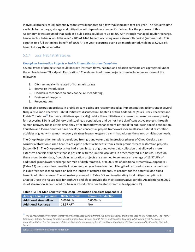
WRIA11StreamflowRestorationAddendum
5-55
Individualprojectscouldpotentiallystoreseveralhundredtoafewthousandacre-feetperyear.Theactualvolume
availableforrecharge,storageandmitigationwilldependonsite-specificfactors.Forthepurposesofthis
Addendumitwasassumedthateachof5sub-basinscouldstoreupto200AFYthroughmanagedaquiferrecharge,
henceeachsub-basinwouldhavea0-200AFMARbenefitoccurringoverasix-monthperiod(summer-fall).This
equatestoafullwatershedbenefitof1000AFperyear,occurringoverasix-monthperiod,yieldinga2.7626cfs
benefitduringthosemonths.
5.1.4 Local Habitat Strategies
FloodplainRestorationProjects–PrairieStreamRestorationTemplates
Severaltypesofprojectsthatcouldimproveinstreamflows,habitat,andripariancorridorsareaggregatedunder
theumbrellaterm“FloodplainRestoration.”Theelementsoftheseprojectsoftenincludeoneormoreofthe
following:
1. Ditchremovalwithrelatedoff-channelstorage2. Beaverre-introduction3. Floodplainreconnectionandchannelre-meandering4. EngineeredLog-jams5. Re-vegetation
FloodplainrestorationprojectsinprairiestreambasinsarerecommendedasimplementationactionsunderseveralNisquallySalmonRecoveryHabitatInitiativesdiscussedinChapter4ofthisAddendum(MuckCreekRecoveryandPrairieTributaries10RecoveryInitiativesspecifically).WhiletheseinitiativesarecurrentlyrankedaslowerpriorityforrecoveringESA-listedChinookandsteelheadpopulationsanddonothavesignificantactiveprojectsthroughsalmonrecoveryfundsatthistime,theyofferstreamflowenhancementpotentialforsub-basinspecificmitigation.ThurstonandPierceCountieshavedevelopedconceptualprojectframeworksforsmall-scalehabitatrestorationactivitiesalignedwithsalmonrecoverystrategyinprairie-typestreamsthataddressthesemicro-mitigationneeds.
TheOhopRestorationtemplatedevelopedfromgroundwaterdatainpreviousphasesofOhopCreekstream
corridorrestorationisusedheretoanticipatepotentialbenefitsfromsimilarprairiestreamrestorationprojects
(AppendixE).TheOhopprojectsiteshadalonghistoryofgroundwaterdatacollectionthatallowedamore
extensiveanalysisofbenefitsthanispossiblewiththelimitedlocaldatainothertargetedsub-basins.Basedon
thesegroundwaterdata,floodplainrestorationprojectsareassumedtogenerateanaverageof13.57AFYof
additionalgroundwaterrechargepermileofditchremoved,or0.0096cfsofadditionalstreamflow.AppendixE
(TableA3)calculatesflowbenefitsinacrefeetperyearbasedonthefulllengthofrestoredstreamchannels,and
incubicfeetpersecondbasedonhalfthelengthofrestoredchannel,toaccountforthepotentialone-sided
benefitsofditchremoval.TheestimatespresentedinTable5-5andinestimatingtotalmitigationoptionsin
Chapter7usethehalvedrateforbothAFYandcfstoprovidethemostconservativebenefit.Anadditional0.0009
cfsofstreamflowiscalculatedforbeaverintroductionpertreatedstreammile(AppendixE).
Table5-5:Per-MileBenefitsfromOhopRestorationTemplate(AppendixE)Averagebenefitpermile: DitchRemoval BeaverIntroductionAdditionalstreamflow 0.0096cfs 0.0009cfsAdditionalRecharge 13.57AFY N/A
10TheSalmonRecoveryPrograminitiativesarecategorizedusingdifferentsub-basingroupingsthanthoseusedinthisAddendum.ThePrairie
TributariesSalmonRecoveryInitiativeincludesprairie-typestreamsinbothPierceandThurstonCounties,whileMuckCreekRecoveryisa
separateinitiative.Forthepurposesofthissectionaddressingcounty-ledstreamflowmitigationprojectsareorganizedbyPlanningUnitsub-
basins.

WRIA11StreamflowRestorationAddendum
5-56
TheselectedprojectconceptsinThurstonandPierceCountiesmeetthefollowingcriteriaforapplicabilitytothe
Ohoptemplate:
1. Similarhydrology:knownorprobableditchingofthestreamtostraighten/movethestreambed.Thisistypicallyassociatedwitha‘compressed’meanderwidthandanincisedstreambed;
2. Similarvegetation;3. Similargeology;4. Similarprecipitation;5. Uplandstreamreaches,wherenewrechargewouldwetalongerstreamreach;6. Mappedpresenceofwetlands,hydricsoilsorseasonalpondedwater;7. Locatedonlargelandparcels,witheitheroneownerorasmallnumberofowners.
BecausetheseprojectsarestilllargelyconceptualandmayvaryfromtheOhoptemplatemodel,thequantified
flowbenefitsfromimplementationareapproximateandwillbefurtherrefinedasspecificprojectsmoveforward.
Additionally,substantialliteratureexiststodemonstratetheeffectivenessoftheserestorationapproachesfor
salmonidrecovery.Evenwhenthestreamflowbenefitsmaybenon-quantifiableataparticularprojectsite,these
projectssupporttheoverallnetecologicalbenefitgoalsforsalmonrecoveryinthewatershed.Thesesub-basin-
scaleprojectscouldbefunded,inpart,bythefeescollectedthroughthepermittingstrategydescribedhereinand
byStreamflowRestorationGrantfunds.
ThurstonCountyHabitatRestorationProjects
ThurstonCountyhasidentified19candidatestreamreachestotaling18.2streammileswithintheThurstonCounty
portionofWRIA11wherefloodplainrestoration-typeprojectscouldbeconsidered.Somecandidatestream
reachesarealready-plannedprojects;othersarenewly-identifiedprojects.Specificlocationsforthesereachesare
notpresentedatthistime,pendingfundingavailabilityandfurtherproject-specificevaluations.Targetedreaches
fallintheThompson/YelmandLackamas/Toboton/Powellsub-basins.
Inpracticalterms,itislikelythatonlyaportionofthe19candidateprojectsinThurstonCountywillactuallybe
constructed.ThurstonCountyestimatedthebenefitifonlyasmallnumberofthesecandidateswillresultin
constructedprojectsbenefittingstreamflow–limitedbyfundingavailability,sitefeasibility,andlandowner
willingness,amongotherfactors.Flowbenefitsestimatedfromimplementing100%,30%,and10%ofThurston
CountyrestorationprojectsaresummarizedinTable5-6.
PierceCountyHabitatRestorationProjects
ThestreamsinthePrairieTributariessub-basininPierceCountyareknowntohaveahighproportionofdegraded
habitat,butthebasiniscurrentlyunderstudied(NisquallySteelheadRecoveryTeam,2014).Itisbelievedthat
thesesystemshistoricallyhadalargepercentageofbeaverpondsandcomplexoff-channelpools,providingwater
storageandjuvenilesalmonhabitatduringtheportionoftheyearwhenintermittentprairiestreamsdonotflow
(Pollocketal,2003).Ditchingandotheragriculturalimpactshaveleftsignificantportionsofprairiestreams
disconnectedfromhistoricalfloodplains.PierceCountyhasnotyetidentifiedspecificcandidatereachesforproject
implementation,butisexploringareaswherebeaverintroductionorbeaverdamanalogs,logjams,and
groundwaterchannelsmaybepursuedtoimprovestreamflowsandfloodplainconnectivity(seeAppendixN).The
OhopRestorationtemplatewasappliedtotheentirestreamlengthofMuckCreek,itsmaintributaryLacamas
Creek,andTanwaxCreekasapreliminaryestimateofpotentiallyachievablestreamflowbenefits.Becauseofthe
lackofproject-specificinformationandlocaldata,theseestimateshaveahighdegreeofuncertainty.Inaddition
touncertaintyaboutthenumberandscaleofpotentialprojectsonprivately-heldorprotectedlandsinPierce
County,substantialreachesofMuckCreekfallwithinJointBaseLewis-McChord,whichmayaffectrestoration
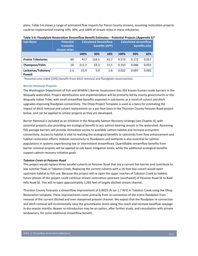
WRIA11StreamflowRestorationAddendum
5-57
plans.Table5-6showsarangeofestimatedflowimpactsforPierceCountystreams,assumingrestorationprojects
couldbeimplementedtreating10%,30%,and100%ofstreammilesinthesetributaries.
Table5-6:FloodplainRestorationStreamflowBenefitEstimates–PotentialProjects(AppendixE)*Sub-Basin Potential
treatablestreammiles
CalculatedStreamflowbenefits(AFY)
Calculatedstreamflowbenefits(cfs)
100% 30% 10% 100% 30% 10%
PrairieTributaries 60 417 124.5 41.7 0.573 0.172 0.057
Thompson/Yelm 16 111.2 33.3 11.1 0.153 0.046 0.015
Lackamas/Toboton/Powell
2.3 15.9 5.0 1.6
0.022 0.007 0.002
*Assumesone-sided(50%)benefitfromditchremovalandfloodplainreconnection.
BarrierRemovalProjects
TheWashingtonDepartmentofFishandWildlife’sBarrierAssessmentlists203knownhuman-madebarriersinthe
Nisquallywatershed.Projectidentificationandimplementationwillbeprimarilyledbycountygovernmentsorthe
NisquallyIndianTribe,withsmallstreamflowbenefitsexpectedinsub-basinsasaresultofculvertandditch
upgradesimprovingfloodplainconnectivity.TheOhopProjectTemplateisusedasabasisforestimatingthe
impactofditchremovalandculvertreplacementonaper-footbasisintheThurstonCountyPeissnerRoadproject
below,andcanbeappliedtosimilarprojectsastheyaredeveloped.
BarrierRemovalisincludedasaninitiativeintheNisquallySalmonRecoverystrategy(seeChapter4),with
potentialprojectsalsoprovidingnetecologicalbenefittoanysalmon-bearingstreaminthewatershed.Removing
fishpassagebarrierswillprovideimmediateaccesstoavailablesalmonhabitatandincreaseecosystem
connectivity.Accesstohabitatisvitaltorealizingtheecologicalbenefitstosalmonidsfromflowenhancementand
habitatrestorationefforts.Habitatconnectivitytofloodplainsandwetlandsisalsoessentialforsalmon
populationsinsystemsexperiencingloworintermittentstreamflows.Quantifiablestreamflowbenefitsfrom
barrierremovalprojectswillbeappliedtosub-basinmitigationtotals,whiletheadditionalecologicalbenefits
supportsalmonrecoveryinitiativegoals.
TobotonCreekatPeissnerRoadThisprojectwouldreplacethreeparallelculvertsatPeissnerRoadthatareacurrentfishbarrierandcontributeto
lowsummerflowsinTobotonCreek.Replacingthecurrentculvertswitha16-footboxculvertwouldopen
upstreamhabitattofishuse.Becausethisprojectwillre-opentheupperreachesofTobotonCreektohabitat,
futurephasesofthisprojectcouldcontinuestreamrestorationupstream(southwest)ofPeissnerRoadSEtoBald
HillsRoadSE.Thiswillre-openapproximately1,283feetoflargelyditchedstreamchannel.
ThurstonCountyforecastsastreamflowimprovementof0.0023cfs(or1.7AFY)inTobotonCreekusingtheOhop
Restorationtemplate.Theseimprovementscomeprimarilyfromre-connectionoftheentirefloodplainfrom
removalofthecurrentditchedandover-steepenedpresentchannel.Weexpectthatthefloodplainre-connection
andditchremovalwillincrementallyraisethegroundwaterlevelsalongthisreachandincreasebaseflowseepage
indry-seasonmonths.Beaverre-introductionmaybeanoption,afterfurtherstudy,andconsultationwithprivate
landowners,forsomeadditionalstreamflowbenefit.
WRIA11StreamflowRestorationAddendum
5-58
5.2 Summary of Sub-Basin Mitigation Options Insummary,thisplanproposestomitigatestreamflowimpactswithacombinationofmitigationalternatives:
i. Finishingnewpermit-exemptwell(s)inadeeperaquiferii. Retiringoneormoreexistingpermit-exemptwellsiii. Re-drillingexistingGroupAwell(s),orothergrandfatheredsystems,tofinishthemtodrawfromdeeper
aquifersiv. Retiringallorpartofanexistingwaterrightcurrentlydrawingwaterfromtheupperaquiferordirectly
fromflowimpairedtributaries.v. AquiferRechargevi. Smallscalehabitatrestorationprojectswithinspecifictributariesthatprovidelocalflowbenefits.
Inaddition,theabilityoftheCityofYelmtoacquireanewwaterrightandextendtheirwatersystemtoservicethe
YelmUGAwillreducethe22-yearconsumptiveuseforecastfortheThompson/YelmSub-basinby962connections
or62%.
Manyoftheapproachestooffsetstreamflowimpactsofpermit-exemptwelluseinPrairieenvironmentswould
requirethetrackingofmitigationresultingfromwellreplacementwithGroupAorBwatersystemhook-up,well
rehabilitationefforts,waterrightacquisition,andbenefitsfromaquiferrechargeandsmallhabitatprojects,as
describedabove.Thisneedfortrackingcouldbemetwithamitigationcreditsystemor”bank”ofsometype.The
PlanningUnitexpectstoworkwithEcologyandImplementingGovernmentstodeveloptrackingand
implementationforamitigationcreditsystemasneeded.County-specificstrategiesarediscussedinChapter6.
ThenextstepstowardimplementingWRIA-widemitigationtrackingareaddressedinChapter8.
WRIA11StreamflowRestorationAddendum
6-59
Chapter 6 County Strategies
InadditiontotheDepartmentofEcology,theNisquallyIndianTribe,andotherpartners,thethreecounties
(Thurston,PierceandLewis)willberesponsibleforimplementingsomeaspectsofthemitigationstrategies
developedinthePlanAddendumthroughtheirprocessesforissuingbuildingpermits.Thischaptersummarizesthe
existingregulatoryframeworkofthecountiesandinitialapproachestoimplementation.
RCW90.94.020currentlyrequiresCountiestodothefollowing:
(a)Recordrelevantrestrictionsorlimitationsassociatedwithwatersupplywiththepropertytitle;(b)Collectapplicablefees,asdescribedunderthissection;(c)Recordthenumberofbuildingpermitsissuedunderchapter19.27RCWorsubdivisionapprovalsissuedunderchapter58.17RCWsubjecttotheprovisionsofthissection;(d)Annuallytransmittothedepartmentthreehundredfiftydollarsofeachfeecollectedunderthissubsection;(e)Annuallytransmitanaccountingofbuildingpermitsandsubdivisionapprovalssubjecttotheprovisionsofthissectiontothedepartment;(f)Untilruleshavebeenadoptedthatspecifyotherwise,requirethefollowingmeasuresforeachnewdomesticusethatreliesonawithdrawalexemptfrompermittingunderRCW90.44.050:
(i)Anapplicantshallpayafeeoffivehundreddollarstothepermittingauthority;(ii)AnapplicantmayobtainapprovalforawithdrawalexemptfrompermittingunderRCW90.44.050fordomesticuseonly,withamaximumannualaveragewithdrawalofthreethousandgallonsperdayperconnection.
Section6.1addressesdevelopmentofThurstonCountypolicy.MuchofThurstonCountyhassimilarhydrogeology
astheportionoftheCountylocatedintheNisquallyWatershed.Therefore,ThurstonCountyhasdevoted
considerablestafftimetodevelopingitsimplementationstrategyanditsdraftstrategymightserveasasuitable
modelforothercountiesastheymoveforwardinimplementingstrategiesdevelopedthroughthestreamflow
restorationandenhancementprocess.
Section6.2and6.3ofthischaptersummarizeregulatoryandimplementationinformationfromPierceandLewis
Counties,respectively.PierceandLewisCountyplansarelessdetailedatthistime,pendingfurtherassessmentof
needsintheNisquallyandotherwatershedsinthesecounties.
ThePlanningUnithasreviewedtheimplementationstrategiesdevelopedbythecountiesandendorsesthemfor
inclusioninthisWatershedPlanAddendum,recognizingthatthisPlanAddendumdoesnotsupplantthelegislative
authorityoflocalgovernmentsandthatanyspecificobligationsorchangestocountycodes,fees,orprocesseswill
bedeterminedduringfutureimplementationphasesthatincludeanyrequiredpublicreviewprocess.
6.1 Thurston County ThurstonCountyregulatesnewdevelopmentthroughtheThurstonCountyCode(Titles14-26),adoptedbythe
BoardofCountyCommissioners(BoCC),andregulateswatersuppliesunderArticleIIIoftheThurstonCounty
SanitaryCode,adoptedbytheBoardofHealth(BoH).
ApplicantsforanewresidentialstructurearerequiredtocompleteaCertificateofWaterAvailability(COWA)
beforethecountywillissueabuildingpermit.TheCOWAisusedtoassesswhethertheapplicanthasapotable
watersupplythatmeetstherequirementsofchapter19.27RCWandtheThurstonCountySanitaryCode.

WRIA11StreamflowRestorationAddendum
6-60
Applicantswhowishtorelyonapermit-exemptwellmustattachawelldriller’sreportshowingthatthewellcan
pumpenoughcapacitytomeettheirwaterneeds(e.g.,400gallonsperdayforasingle-familyresidence)andthat
thewatercomingfromthewellmeetswaterqualitystandards.TheCountydoesnotcurrentlyreviewhowthe
proposedwaterusewouldaffectothernearbywaterrightholders.
Withfewexceptions,applicantscannotchoosetouseapermit-exemptwellastheirwatersourceiftheyarewithin
theserviceareaofanexistingwatersystem.Section5.2.3ofArticleIIIoftheThurstonCountySanitaryCodestates
that:
“Nonewwatersourceshallbelocatedinareaswherewaterisavailablefromanexistingpublicwatersystem.The
healthofficermayexemptanapplicantfromthisrequirementiftheapplicantdemonstratesallofthefollowing:
(a)Thewatersourcemeetsallstandardsforisolationandconstructionwithoutvariancesorwaivers;and
(b)Thelocationofthenewsourceisconsistentwithallotherapplicablewatersupplyrequirements,land
useplans,andgroundwatermanagementplans;and
(c)TheapplicantreceivesapprovalfromthejurisdictionalHearingsExamineronanappealorvariance
fromthepriorityofservicepertheapplicableThurstonCountyCoordinatedWaterSystemPlan.”
Inmanycases,awellhasbeendrilledbeforetheapplicantapproachesthecountyforabuildingpermit–
sometimesmanyyearsprior.Thecountyistypicallynotifiedwhenanewwellisconstructedbywelldrillersand
theDepartmentofEcologyissuesastartcard;however,thewellatthistimeisnotnecessarilyassociatedwithany
developmentthatmightrequireacountypermit.
ThefollowingareregulatorystrategiesthatarebeingconsideredordevelopedbyThurstonCountyatthistime.
TheywillbefullydevelopedasThurstonCountyparticipatesintheotherWRIAsaddressingRCW90.94.030.
6.1.1 Thurston County Water Availability Permitting Process Review Underthisstrategy,ThurstonCountywouldconsideramendingitsreviewprocessforbuildingpermitsand
establishingafeeandcreditsystemfornewresidentialdevelopmentthatreliesonapermit-exemptwell.
Inadditiontolegislativeactionbythecounty,thisstrategywouldrequireEcologytoconductrulemaking,as
specifiedinRCW90.94(2)(e),toreplacethe$500feeestablishedbyRCW90.94(5)(f)(i)withasystemofcharges
basedontheestimatedimpactofthedevelopmentdeterminedthroughassessmentoftheactualannualaverage
consumptiveuse,basedonavailablelocalwateruseinformation(suchasthatprovidedbyThurstonPUD).Aswith
thecurrentfeestructure,applicantsthatconnecttoanexistingpublicwatersystem(GroupAorstate-permitted
GroupB)orthatotherwiseprovideevidenceofawaterrightwouldnotbesubjecttothisfee.
Theapplicantwouldpayareducedfeebysubmittingahydrogeologicreportthatmeetscountystandardsand
demonstratesimpacttostreamflowsfromtheproposeddevelopmentbelowtheaverageannualstandardsetby
thecounty.Alternatively,theapplicantwouldpayareducedfeeiftheycommittocertainmeasuresintheir
buildingapplication,suchas:
• Attendingapre-submissionconferencetoreviewrequirementswithcountystaff• Submittingahydrogeologicreportthatmeetsdepartmentstandardsanddemonstrateslimitedorno
impact• Finishingwellinadeeperaquiferwithlessconnectiontosurfacewaterflows• Installingwaterconservingfixturesorotherinfrastructuretominimizewateruse,asapprovedbycounty
standards

WRIA11StreamflowRestorationAddendum
6-61
• InstallinginfiltrationfacilitiesabovewhatisrequiredthroughtheDrainageDesignandErosionControlManual(TCC15.05.010)
• Userainwaterharvesting/cisternstoaugmentwatersupply,aspermittedbycountystandards• OtherstrategiesasdeterminedappropriatebytheThurstonCountyreviewingauthority
Feeswouldbeusedtofundstreamflowrestorationprojectsinthebasinswheretheyarecollected(suchasthose
describedinChapters4and5)andadministrationofthewateravailabilityprogram.Additionaldetails,including
theappropriatefeestructure,programadministration,andnecessarychangestotheThurstonCounty
developmentcodeandSanitaryCodewillbedeterminedafteradditionalinvestigation.
AnychangestoThurstonCountycodewouldbereviewedthroughthecounty’sstandardpublicprocessandbe
subjecttoadoptionbyitslegislativeauthority(BoardofCountyCommissioners/BoardofHealth),asappropriate.
Thequantitativebenefitofthisactiononstreamflowswilldependonthenumberofpermit-exemptwellconnectionsthatareprocessedunderthenewrules.Chapter3estimates2,147futurepermit-exemptwellconnectionsforThurstonCountyoverthe22-yearplanningperiod(seeSection3.2.1),withanActualannualconsumptivewateruseestimatedat230acrefeetperyear(seeSection3.3.2).Thisistheestimatedmaximumamountofbenefit.However,thistotaldependsontheoutcomesofotheractionsidentifiedthroughoutthisAddendumandwouldbeaffectedbyseveralfactors:
• Thelengthoftimeittakestodevelopandimplementarevisedpermittingandfeesystem.Developmentapplicationssubmittedintheinterimwouldcontinuetobesubjecttothestate-mandatedwellfee,requiredbyRCW90.94.
• WhethertheCityofYelmisabletoprovidewaterservicetonewresidentialdevelopmentinitsUrbanGrowthArea(UGA).AsoutlinedinSection5.1.1,ifYelm’sdeeperwellisapproved,theamountofwaterusefrompermit-exemptwellscouldbereducedbynearly1,000connections.
• Whetherotherpublicwatersystemsareabletoexpandand/orservemoreconnectionsthanpredicted,duetoincentivesorupgrades.
• Whetherdevelopmentpatternschange,duetoeconomicorsocialdrivers,includingthefeessetthroughthisprogram.
Thequantitativebenefitforthisactionwillbeindirectproportiontothenumberofresidentialbuildingpermitsapprovedundertherevisedpermittingprocess,andonthedetailsofthatprocess.Inaddition,thisactioncouldhelptofundsomelocalfloodplainrestorationprojectsidentifiedandquantifiedinSection5.1.4.
6.1.2 Revolving Loan and Grant Fund for Small Public Water Systems ThurstonCountywouldinvestigatethefeasibilityofestablishingandoperatingarevolvingloanfundforpublic
watersystemstoincreasetheefficiencyofsuchsystemsandreduceimpactstostreamflows.Thefundwouldbe
usedtoenablesmallwatersystemstoinvestinsystemupgrades,suchasadeeperwellormoreefficient
conveyanceinfrastructure,establishatieredratesystem,expandtomoreconnections,establishprofessional
management,minimizeconnectionfees,orotherdesignupgradesorstrategiestoreduceandoffsetimpactsto
streamflows(seeChapter5.1.1).ThefundwouldprimarilytargetsmallerpublicwatersystemsinThurstonCounty
establishedpriortoMay1,1994thatareconsideredprovisionallyadequate,butdonotmeetthecurrentdesign
standardsoftheThurstonCountySanitaryCode(ArticleIII),WAC246-290orWAC246-291.Theprogrammayalso
bemadeavailabletootherwatersystemsthatcouldbenefitfromefficiencyupgrades.Thisprogramcouldbe
funded,inpart,bythefeescollectedthroughthepermittingstrategydescribedabove.
ThequantitativebenefitofthisactiononstreamflowsintheNisquallywatersheddependsonthenumberandtype
ofimprovementsfunded,andtheamountoffundinggeneratedbypermittingfeesorotherfundingsources.
BenefitsfundedbypermittingfeesaloneareincludedinthecalculatedbenefitforSection6.1.1.
WRIA11StreamflowRestorationAddendum
6-62
ThePlanningUnitendorsesThurstonCounty’sproposedapproachasmeetingtheintentofRCW90.94.020
recognizingthatitrequiresEcologyrulemaking,countylegislation,andfurtherevaluationasitproceedsthrough
otherwatershedplanningprocesses.ThePlanningUniturgestheothercountiestoconsideradoptingasimilar
countyregulatoryapproach.
6.1.3 Stormwater Management UnderthiselementofthePlanAddendum,ThurstonCountywouldcontinuetoexplorewaystoaccountforconsumptivewateruseacrosstypicaldevelopment,includingquantifyingbenefitsofexistingandexpandedstormwatermanagementpoliciesthatincreaseonsiteinfiltrationandresultingroundwaterrecharge.InitialestimatesindicatethatcertaintypesofdevelopmentintheNisquallyWatershedcanresultinanetbenefittogroundwaterrechargewhenconsideringstormwatermanagementrequirementsunderstateguidelinesandtheThurstonCountyDrainageDesignandErosionControlManual,includingcorerequirementsforlowimpactdevelopmentandflowcontrol(ThurstonCountyStormwaterUtilityMemorandum,2018).StormwaterfacilitiesapprovedthroughThurstonCounty’sdevelopmentpermittingprocess,includingthosethatpromoteincreasedinfiltrationthroughlowimpactdevelopment,mustmeetthespecificationsoftheDrainageDesignandErosionControlManual(TCC15.05.010),whichincludelong-termoperationandmaintenance(CoreRequirement#9).Formanyfacilities,acceptanceofamaintenanceplanisrequiredpriortofinalprojectapproval,andsuchfacilitiesareregularlymonitoredandinspectedunderThurstonCounty’sStormwaterUtilityprogramsinordertomeettheCounty’sobligationsunderthePhaseIIMunicipalstormwaterpermitforWesternWashington.
Thequantitativebenefitofthisactiononstreamflowsdependsonadditionalresearchandpolicydevelopment–anybenefitsfromthisactionwouldberolledintothecalculatedbenefitforSection6.1.1.
6.2 Pierce County TheTacomaPierceCountyHealthDepartmentregulatesthedrillingofnewindividualwellswithinPierceCounty
underChapter3oftheTacoma-PierceCountyHealthDepartmentEnvironmentalHealthCode(Tacoma-Pierce
CountyBoardofHealthResolutionNo.2010-4221).ThePierceCountyComprehensivePlancontainsapolicythat
nonewindividualwellsareallowedintheUrbanGrowthAreaexceptforspecialcircumstances.Inorderto
implementthatpolicy,PierceCountylanduseregulationsrequiredanapplicantwishingtoconstructanindividual
wellwithinanurbangrowthareatoobtainwrittenconsentfortheconstructionofthewellfromPierceCounty
PlanningandlandServicesDepartmentpriortoapprovalofthewellbytheTacomaPierceCountyHealth
Department.However,mostofWRIA11inPierceCountyisoutsidetheUrbanGrowthArea.
OtherTacomaPierceCountyHealthDepartmentregulationsandpoliciespertainingtoindividualwellsincludethe
following:
• Anindividualwellmustproduceatleast400gallonsofwaterperdaytobeconsideredadequatewithrespecttoquantity,and;
• Ifaparcelispartofasubdivisionorshortsubdivisionthatgainedapprovalsubjecttotheprovisionofpublicwater,oriftheparcel’sbuildingpermitwasconditionedupontheuseofpublicwater,thenanewindividualwellontheparcelmaynotbeapproved.(TacomaPierceCountyBoardofHealthResolutionNo.2010-4221).
• Tacoma-PierceCountyHealthDepartmentrequiresnotification48hourspriortoanywellconstructionfromawelldriller.ThisnotificationmustincludeaNotice-of-IntentnumberprovidedbytheWashingtonStateDepartmentofEcology.
• TheHealthDepartmentmaynotgrantapprovalfornewwellsthatdemonstrateanadverseimpactonothernearbywellsortotheresource.
WRIA11StreamflowRestorationAddendum
6-63
TheTacomaPierceCountyHealthDepartmentregulatesGroupBwatersystemsoperatingwithinPierceCounty.In
regardstonewdevelopmentsproposingtoutilizeaGroupBwatersystemasthesourceofwater,thefollowing
regulationsapply:
• IftheproponentofaprojectproposesthecreationofanewGroupBWaterSystemtoservetheproject,thentheproponentshallassignandrecordanallocationofwaterofatleast750gallonsperdayforeachnewlycreatedlot;
• NonewlyformedGroupBWaterSystemmayhavemorethansixconnectionswithoutdemonstratingapprovalofwaterrightsbytheWashingtonStateDepartmentofEcologyand;
• Maximumnumberoflotsforaproposedsubdivisioncannotexceedthefollowingcriteria:ProposedGroupBwatersystem–6lots.Proposedindividualwells–12lots.
PierceCountyregulatestheissuanceofbuildingpermitsandsentoutanIndustryNoticeonJanuary22,2018in
responsetoESSB6091withthefollowingchanges:
• Thecountywillnolongerrequireahydrogeologicstudyassociatedwithpermit-exemptwellapplications(CountyPolicyDW2016-02:BuildingPermits/SubdivisionsonNewPermit-ExemptWellsisnolongerineffect)
• Building/SubdivisionPermitsintheNisquallyWaterResourceInventoryArea(WRIA11)proposingtousepermit-exemptwells:
o Limitedto3,000gallonsperday(maximumannualaverageuseandnometeringrequired)o Newfeeof$500($350toEcology,$150toCountyforreportingrequirements)o Requiresrecordingofrestrictionsontitle(additionalrecordingfee)
• Building/SubdivisionPermitsinthe#10Puyallup-White,#12Chambers-Clover,and#15KitsapWRIAsproposingtousepermit-exemptwells:
o Limitedto950gallonsperday(maximumannualaverageuseandnometeringrequired)o Newfeeof$500($350toEcology,$150toCountyforreportingrequirements)o Requiresrecordingofrestrictionsontitle(additionalrecordingfee)
Thenewfeewillberequiredforthefollowingactivitieswithdrilled“permit-exempt”wells:
• Allnewresidentialbuildingpermitapplications,includingaccessorydwellingunits
• Commercialbuildingpermitapplications(historicalwaterestimatesreviewedandacceptedpriortopermitissuance)
• Subdivisionsofland
Positiononproposedpermit-exemptwellsitespecificmitigationapproaches/strategies
Giventheshortamountoftimetoreviewthemitigationapproachesandstrategies,andwithuncertaintyasto
whetherornottheyarenecessary,PierceCountycanonlycommittoworkingwithstakeholdersandinvestigating
thefollowingasoptionalapproaches/strategies.Itmustbeunderstoodthatsite-specificmitigationmaynotbe
necessaryifotherwatershedprojectshavesufficientbenefittooffsettheimpactsoffuturepermit-exemptwells.
6.2.1 “Cafeteria” Menu Approach Ifitisdeterminedthatidentifiedprojectsdonotmeetnecessaryoffsets,PierceCountycouldfurtherinvestigatean
incentivebased“cafeteria”mitigationcreditconcept.Thisconceptmayentailamenuofpossiblechoicesthatthe
propertyownermaypursue,includingtheoptiontopurchaseashareinalargersub-basinwidemitigationproject.
Ifthisconceptispursued,itneedsrefinementtoaddressthetotalcreditsneedsandcreditsassociatedwith
individualmenuitems.Themenumayinclude,butisnotlimitedto:
WRIA11StreamflowRestorationAddendum
6-64
• Drillingnewwellsinadeeperaquifer.• Decommissioningexistingpermit-exemptwellsinthesamegeneralsub-basin.• Installingmeteronnewwelltomonitorwaterusage.• Agreementtolimitdailywateruse.• Agreementtoreportmeteredwateruse
Ifnecessary,furtherdevelopmentofthis“CafeteriaMenu”approachwillbeaddressedaspartoftheAdaptiveManagementProcess(seeChapter8).
6.2.2 Other Potential Mitigation Strategies Ifadditionalprojectsarenecessarytomitigatepermit-exemptwells,otherpotentialmitigationprojectsmaybe
investigatedtodeterminethebenefitsandcosts.Theseprojectsmaybethoseinwhichindividualpropertyowners
may,throughthe“Cafeteria”approach,purchaseashareoftheproject.Thetypeofprojectsmayinclude,butare
notlimitedto:
• Near-stream“storage-and-release”projects• MovepumpingofGroupAorGroupBwatersystem(s)intodeeperaquifer(s)• PurchasingConservationEasements/EstablishmentofWaterBank• Retiringexistingwaterrights.
Itshouldberecognizedthatthesetypesofprojectsmayhaveunintentionalconsequencesifnotfullyevaluated.
“Storage-and-release”projectsmustbedesignedtoavoidwarmingthestream’swatertemperature.Thepotential
impactstopromotinganeconomicallyviableagriculturalindustrymustberecognizedifpursuingtheretirementof
waterrightsorpurchasingwatereasements.
6.3 Lewis County GiventhefactthatasmallamountofdevelopmentisprojectedinLewisCounty’sportionoftheUpperNisqually
watershed,andthefactthatnoneofthestreamsintheareaareclosedtofurtherappropriation,LewisCounty
doesnotproposeanysetmitigationapproachesforthearea.Futuredevelopmentthatdoesoccurwilllikelybe
seasonallyoccupiedbyvisitorsandwillrequirelimitedwaterforconsumptiveuse.Theforestedlandscapeand
seasonalnatureofthehomeswilllimittheneedforirrigationandtheassociatedwaterthatislostto
evapotranspiration.Overall,theimpactstostreamflowassociatedwithdevelopmentintheareaareanticipatedto
beminimal.
AsLewisCountyparticipatesintheplanningforotherwatersheds(particularlyWRIA23–theUpperChehalis
watershed),theCountywillconsiderchangestothecountywidebuildingand/ordevelopmentstandardsto
addresswaterusageandpoliciesforpermit-exemptwells.Asthepoliciesareimplementedintheotherbasins,
LewisCountymayalsoelecttohavethepoliciesappliedtoLewisCounty’sportionoftheUpperNisquallybasin.
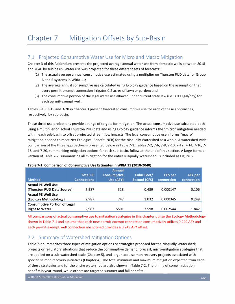
WRIA11StreamflowRestorationAddendum
7-65
Chapter 7 Mitigation Offsets by Sub-Basin
7.1 Projected Consumptive Water Use for Micro and Macro Mitigation Chapter3ofthisAddendumpresentstheprojectedaverageannualwaterusefromdomesticwellsbetween2018
and2040bysub-basin.Waterusewasprojectedforthreedifferentsetsofforecasts:
(1) TheactualaverageannualconsumptiveuseestimatedusingamultiplieronThurstonPUDdataforGroup
AandBsystemsinWRIA11;
(2) TheaverageannualconsumptiveusecalculatedusingEcologyguidancebasedontheassumptionthat
everypermit-exemptconnectionirrigates0.2acresoflawnorgarden;and
(3) Theconsumptiveportionofthelegalwateruseallowedundercurrentstatelaw(i.e.3,000gal/day)for
eachpermit-exemptwell.
Tables3-18,3-19and3-20inChapter3presentforecastedconsumptiveuseforeachoftheseapproaches,
respectively,bysub-basin.
Thesethreeuseprojectionsprovidearangeoftargetsformitigation.Theactualconsumptiveusecalculatedboth
usingamultiplieronactualThurstonPUDdataandusingEcologyguidanceinformsthe“micro”mitigationneeded
withineachsub-basintooffsetprojectedstreamflowimpacts.Thelegalconsumptiveuseinforms“macro”
mitigationneededtomeetNetEcologicalBenefit(NEB)fortheNisquallyWatershedasawhole.Awatershed-wide
comparisonofthethreeapproachesispresentedbelowinTable7-1.Tables7-2,7-6,7-8,7-10,7-12,7-14,7-16,7-
18,and7-20,summarizingmitigationoptionsforeachsub-basin,followattheendofthissection.Alarge-format
versionofTable7-2,summarizingallmitigationfortheentireNisquallyWatershed,isincludedasFigure5.
Table7-1:ComparisonofConsumptiveUseEstimatesinWRIA11(2018-2040)
MethodTotalPE
Connections
AnnualConsumptive
Use(AFY)CubicFeet/
Second(CFS)CFSper
connectionAFYper
connectionActualPEWellUse(ThurstonPUDDataSource) 2,987 318 0.439 0.000147 0.106ActualPEWellUse(EcologyMethodology) 2,987 747 1.032 0.000345 0.249ConsumptivePortionofLegalRighttoWater 2,987 5501 7.598 0.002544 1.842
AllcomparisonsofactualconsumptiveusetomitigationstrategiesinthischapterutilizetheEcologyMethodology
showninTable7-1andassumethateachnewpermit-exemptconnectionconsumptivelyutilizes0.249AFYand
eachpermit-exemptwellconnectionabandonedprovidesa0.249AFYoffset.
7.2 Summary of Watershed Mitigation Options Table7-2summarizesthreetypesofmitigationoptionsorstrategiesproposedfortheNisquallyWatershed;
projectsorregulatorysituationsthatreducetheconsumptivedemandforecast,micro-mitigationstrategiesthat
areappliedonasub-watershedscale(Chapter5),andlargerscalesalmonrecoveryprojectsassociatedwith
specificsalmonrecoveryinitiatives(Chapter4).Thetotalminimumandmaximummitigationexpectedfromeach
ofthesestrategiesandfortheentirewatershedarealsoshowninTable7-2.Thetimingofsomemitigation
benefitsisyear-round,whileothersaretargetedsummerandfallbenefits.

WRIA11StreamflowRestorationAddendum
7-66
Table7-2:SummaryofWatershedMitigationOptions(seeendofchapterandFigure5forlarge-scaleversion)
County-widepoliciesaffectingwateravailabilityforruralresidentialdevelopmentcontinuetobeconsideredas
partofotherWRIAprocessesandarenotyetavailabletobeincludedinthesesub-basinandwatershedwide
totalsofmitigationoffsets.DeepGroundwaterOptions1through3willbequantifiedonaprojectspecificand
well-specificbasisandarealsonotincludedinthetotalmitigationoffsetshowninTable7-2.Itisexpectedthat
0.249AFYperwellwillbecreditedforeachwellassociatedwithmostprojects.ThePlanningUnitexpectsthatthe
currentprojectsthathavebeenquantifiedinTable7-2willachievefullmitigationofdomesticconsumptiveuseby
forecastpermit-exemptwellconnectionsinthewatershed.
Table7-3providesacomparisonoftheconsumptiveuseestimatesusingtheEcologymethodandtheminimum
andmaximumestimatedmitigationoffsetbysub-basin.Table7-4summarizesthecomparisonofthelegal
consumptiveuse(theconsumptiveportionof3,000gpd/connection)andestimatedmitigationoffsetbysub-basin.
Asdiscussedabove,thisisnotthetotalestimatedmitigationforthewatershedasitdoesnotconsiderfuture
countyregulatorypolicythatmayrequirepermitapplicantstoassistwithmitigation,nordoesitincludeanyofthe
DeepGroundwateroffsetoptions.Becausemanyofthemitigationoptionsarepreliminaryandconceptualin
nature,arangeofvaluesisshownbetweentheminimumandmaximumamountofmitigationpotentially
available.
Table7-3:ActualConsumptiveUse(EcologyMethod)ComparedtoMinimumandMaximumEstimatedMitigation*
Sub-basin
ECYMethodAnnualPEConsumptiveUse(AFY)
ECYMethodAnnualPEConsumptiveUse(cfs)
MitigationActionsIdentified-annualAF(MIN)
MitigationActionsIdentified-annualAF(MAX)
MitigationActions(cfs)MIN
MitigationActions(cfs)MAX
McAllister 39 0.054 TBD TBD TBD TBD
Thompson/Yelm 390 0.539 349.02 762.1 0.479 1.050Lackamas/Toboton/Powell 107 0.148 84.17 504.57 0.116 0.697
LowerNisqually 0.5 0.001 0 200 0 0.552
MashelRiver 5 0.007 1922 4281 3.48 7.27
PrairieTributaries 149 0.206 41.7 1290 0.058 2.058
OhopCreek 7 0.009 24 1336 0.017 2.105UpperNisqually(Pierce,Lewis,Thurston) 49 0.067 49 249 0.067 0.619
TOTAL 747 1.03 2470 8623 4.22 14.35*Figuresareroundedandmaynotcalculatecorrectlyinconversions.Fullvaluesareavailablebyrequestfromthe
PlanningUnit.

WRIA11StreamflowRestorationAddendum
7-67
Table7-4:LegalConsumptiveUseComparedtoMinimumandMaximumEstimateMitigation*
Sub-basin
LegalAnnualPEConsumptiveUse(AFY)
LegalAnnualPEConsumptiveUse(cfs)
MitigationActionsIdentified-annualAF(MIN)
MitigationActionsIdentified-annualAF(MAX)
MitigationActions(cfs)MIN
MitigationActions(cfs)MAX
McAllister 285 0.394 TBD TBD TBD TBD
Thompson/Yelm 2,876 3.973 1946 2359 2.7 3.3Lackamas/Toboton/Powell 792 1.094 84.2 504.6 0.116 0.697
LowerNisqually 4 0.005 0.00 200 0.00 0.552
MashelRiver 37 0.051 1922 4281 3.48 7.27
PrairieTributaries 1,098 1.516 41.7 1290 0.058 2.058
OhopCreek 50 0.069 24 1336 0.017 2.10UpperNisqually(Pierce,Lewis,Thurston) 359 0.496 359 559 0.496 1.048
TOTAL 5,501 7.60 4377 10530 6.86 16.99*Figuresareroundedandmaynotcalculatecorrectlyinconversions.Fullvaluesareavailablebyrequestfromthe
PlanningUnit.
7.2.1 Demand Reduction TherearetwofactorsthatcanbeusedtoadjustconsumptionandreducedemandinWRIA11:TheCityofYelm’s
waterrightandtheregulatorystatusoftheUpperNisquallySub-basin.
Afterapprovaloftheirpendingwaterrightpermitapplication,theCityofYelmintendstoservenewdomesticuses
withintheirwaterserviceareathatwouldotherwisebeservedbypermit-exemptwells.ApprovaloftheCity’s
waterrightwillincludeadequatemitigation,thereforedomesticusesthatareservedbytheCity’swaterrightwill
befullymitigated.RemovingtheestimateddemandforthedomesticusestobeservedbytheCityreducesthe
totalconsumptiveuseintheThompson/Yelmsub-basinandtheentirewatershedby240.5AFYor0.33cfsusing
theEcologymethodologyforcalculatingactualconsumptiveusefordomesticpermit-exemptwellconnections.
TheregulatorystatusoftheUpperNisquallysub-basinincludesinstreamflowvaluesbutitisnotclosed.Because
thissub-basinisabovereservoirsthatreleaseflowtomeetinstreamflows,permit-exemptusesintheUpper
Nisquallywillnotimpairinstreamflows.Therefore,consumptiveuseestimatesfortheupperNisqually(49AFY,
0.067cfsperEcologymethodology)canalsobeviewedasmitigationdemandreduction.
7.3 Water Use and Mitigation Options by Sub-Basin Resultsforindividualsub-basinsareprovidedinthissection,alongwithmitigationoptionsforoffsetting
consumptiveuses.AsCountypoliciesaredevelopedtoaddressruralwaterusethroughthebuildingpermit
applicationprocess,additionalconsumptiveuseoffsetisexpected.Tablesofmitigationbysub-basinareincluded
attheendofthischapter.
7.3.1 McAllister Sub-Basin
ProjectedWaterDemandfromPermit-ExemptWells
Becauseofthevariedlandscapeofthesub-basin,itisuncertainexactlywherethenewconnectionswouldbe
located.AportionareexpectedtobewithintheEatonCreekdrainage.

WRIA11StreamflowRestorationAddendum
7-68
Table7-5:ConsumptiveUseEstimates–McAllisterSub-basin
ForecastMethodTotalPE
ConnectionsAnnualConsumptive
Use(AFY)AnnualConsumptive
Use(CFS)ActualPEWellUse(ThurstonPUDDataSource) 155 16 0.023ActualPEWellUse(EcologyMethodology) 155 39 0.054ConsumptivePortionofLegalRighttoWater 155 285 0.394
MitigationOptions
Table7-6(seeendofchapter)providesasummaryofmitigationoptionsfortheMcAllisterSub-basin.Noneofthe
mitigationoptionsarequantifiedatthistime.
Discussion
AsnotedinChapter2,becausethisportionoftheNisquallyRiverisnotclosedforfutureout-of-streamwater
appropriations,itispossiblethatnewpermit-exemptwellsthattapgroundwaterinconnectionwiththeNisqually
Rivermaybepermittedwithouttheexpectationofoffsetmitigation.FortheMcAllisterCreekarea,virtuallyallthe
landintheNisquallyValleyiszonedlong-termagricultural,withdevelopmentrightspurchasedthrough
conservationeasements.ThetributarytoMcAllisterCreekiswithintheLaceyUGAandthewatersupplyforany
futuredevelopmentwillbemetbyconnectiontoaGroupAwatersystem.
FortheEatonCreekareaandLakeSt.Clair,thereisthepossibilityforasmallnumberoffuturepermit-exempt
wells.Forimpactmitigation,thisplanrecommendsthatpermitapplicantsconsideroffsetoptionsthroughthe
ThurstonCountyBuildingpermitprocess.ThethreeDeepGroundwatermitigationoptionsthatapplytoprairie
streamenvironmentsasdescribedinSection5.1.1areapplicableandarequantifiedonaper-wellbasis.
7.3.2 Thompson/Yelm Sub-Basin
ProjectedWaterDemandfromPermit-ExemptWells
Table7-7:ConsumptiveUseEstimates–Thompson/YelmSub-basin
ForecastMethod
PEConnections(UGA)
PEConnections(Rural)
TotalPEConnections
AnnualConsumptive
Use(AFY)
AnnualConsumptiveUse
(CFS)ActualPEWellUse
(ThurstonPUDData) 1,036 526 1,562 165.6 0.2287ActualPEWellUse(EcologyMethod) 1,036 526 1,562 388.9 0.5372
ConsumptivePortionofLegalRightto
Water 1,036 526 1,562 2877.2 3.9742
MitigationOptions
Table7-8(seeendofchapter)providesasummaryofmitigationoptionsfortheThompson/YelmSub-basin.
Discussion
TheThompson/Yelmsub-basinhasthepotentialforsignificantoffsetofmitigationdemandthroughtheexpansion
oftheCityofYelm’spublicwatersystem.TheCityofYelm,alargeGroupAsystem,hasappliedforwaterrightsin
thedeeperTQuaquifertoexpanditssystemcapabilities.Finalapprovalofthisnewwaterrightandsystem
expansionhasbeendelayedbylitigationconcerningtheadequacyofthemitigationofferedbyYelm.TheCityis
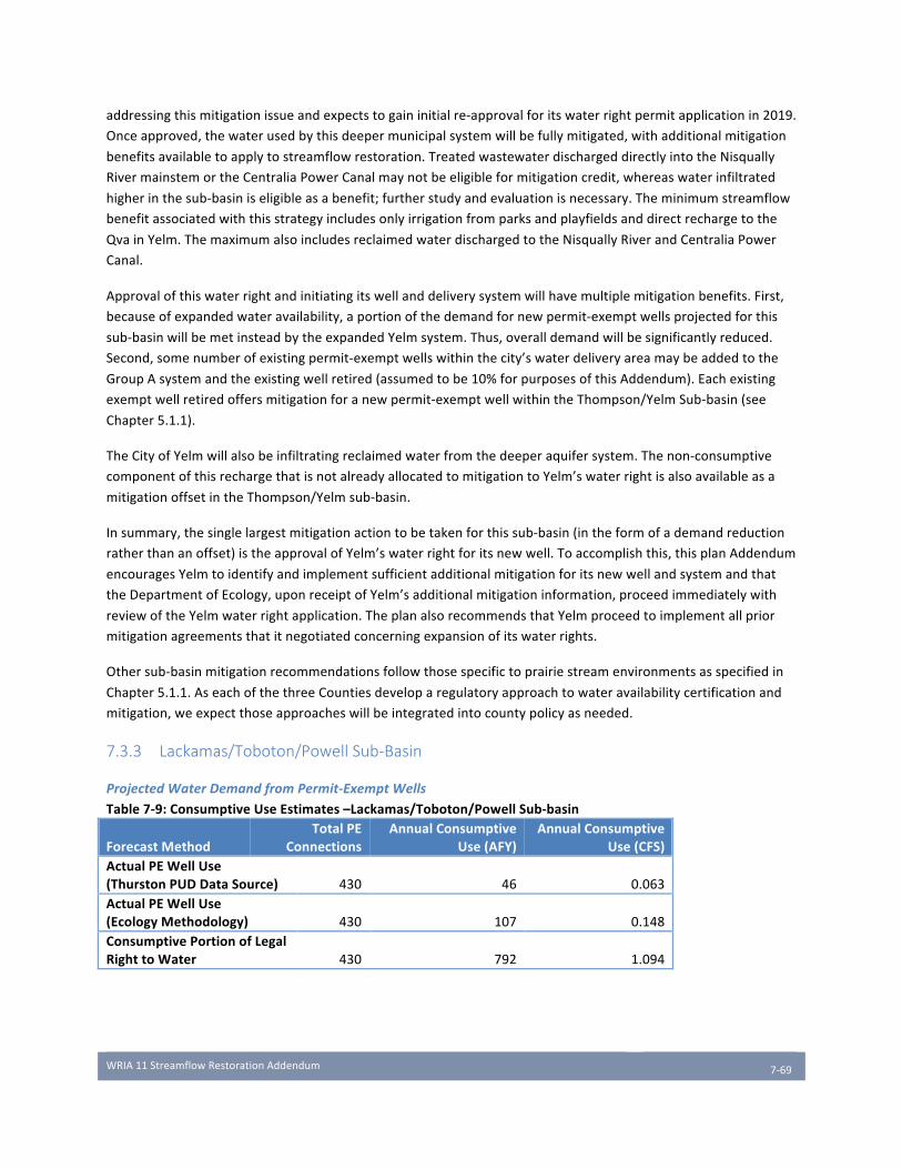
WRIA11StreamflowRestorationAddendum
7-69
addressingthismitigationissueandexpectstogaininitialre-approvalforitswaterrightpermitapplicationin2019.
Onceapproved,thewaterusedbythisdeepermunicipalsystemwillbefullymitigated,withadditionalmitigation
benefitsavailabletoapplytostreamflowrestoration.TreatedwastewaterdischargeddirectlyintotheNisqually
RivermainstemortheCentraliaPowerCanalmaynotbeeligibleformitigationcredit,whereaswaterinfiltrated
higherinthesub-basiniseligibleasabenefit;furtherstudyandevaluationisnecessary.Theminimumstreamflow
benefitassociatedwiththisstrategyincludesonlyirrigationfromparksandplayfieldsanddirectrechargetothe
QvainYelm.ThemaximumalsoincludesreclaimedwaterdischargedtotheNisquallyRiverandCentraliaPower
Canal.
Approvalofthiswaterrightandinitiatingitswellanddeliverysystemwillhavemultiplemitigationbenefits.First,
becauseofexpandedwateravailability,aportionofthedemandfornewpermit-exemptwellsprojectedforthis
sub-basinwillbemetinsteadbytheexpandedYelmsystem.Thus,overalldemandwillbesignificantlyreduced.
Second,somenumberofexistingpermit-exemptwellswithinthecity’swaterdeliveryareamaybeaddedtothe
GroupAsystemandtheexistingwellretired(assumedtobe10%forpurposesofthisAddendum).Eachexisting
exemptwellretiredoffersmitigationforanewpermit-exemptwellwithintheThompson/YelmSub-basin(see
Chapter5.1.1).
TheCityofYelmwillalsobeinfiltratingreclaimedwaterfromthedeeperaquifersystem.Thenon-consumptive
componentofthisrechargethatisnotalreadyallocatedtomitigationtoYelm’swaterrightisalsoavailableasa
mitigationoffsetintheThompson/Yelmsub-basin.
Insummary,thesinglelargestmitigationactiontobetakenforthissub-basin(intheformofademandreduction
ratherthananoffset)istheapprovalofYelm’swaterrightforitsnewwell.Toaccomplishthis,thisplanAddendum
encouragesYelmtoidentifyandimplementsufficientadditionalmitigationforitsnewwellandsystemandthat
theDepartmentofEcology,uponreceiptofYelm’sadditionalmitigationinformation,proceedimmediatelywith
reviewoftheYelmwaterrightapplication.TheplanalsorecommendsthatYelmproceedtoimplementallprior
mitigationagreementsthatitnegotiatedconcerningexpansionofitswaterrights.
Othersub-basinmitigationrecommendationsfollowthosespecifictoprairiestreamenvironmentsasspecifiedin
Chapter5.1.1.AseachofthethreeCountiesdeveloparegulatoryapproachtowateravailabilitycertificationand
mitigation,weexpectthoseapproacheswillbeintegratedintocountypolicyasneeded.
7.3.3 Lackamas/Toboton/Powell Sub-Basin
ProjectedWaterDemandfromPermit-ExemptWells
Table7-9:ConsumptiveUseEstimates–Lackamas/Toboton/PowellSub-basin
ForecastMethodTotalPE
ConnectionsAnnualConsumptive
Use(AFY)AnnualConsumptive
Use(CFS)ActualPEWellUse(ThurstonPUDDataSource) 430 46 0.063ActualPEWellUse(EcologyMethodology) 430 107 0.148ConsumptivePortionofLegalRighttoWater 430 792 1.094
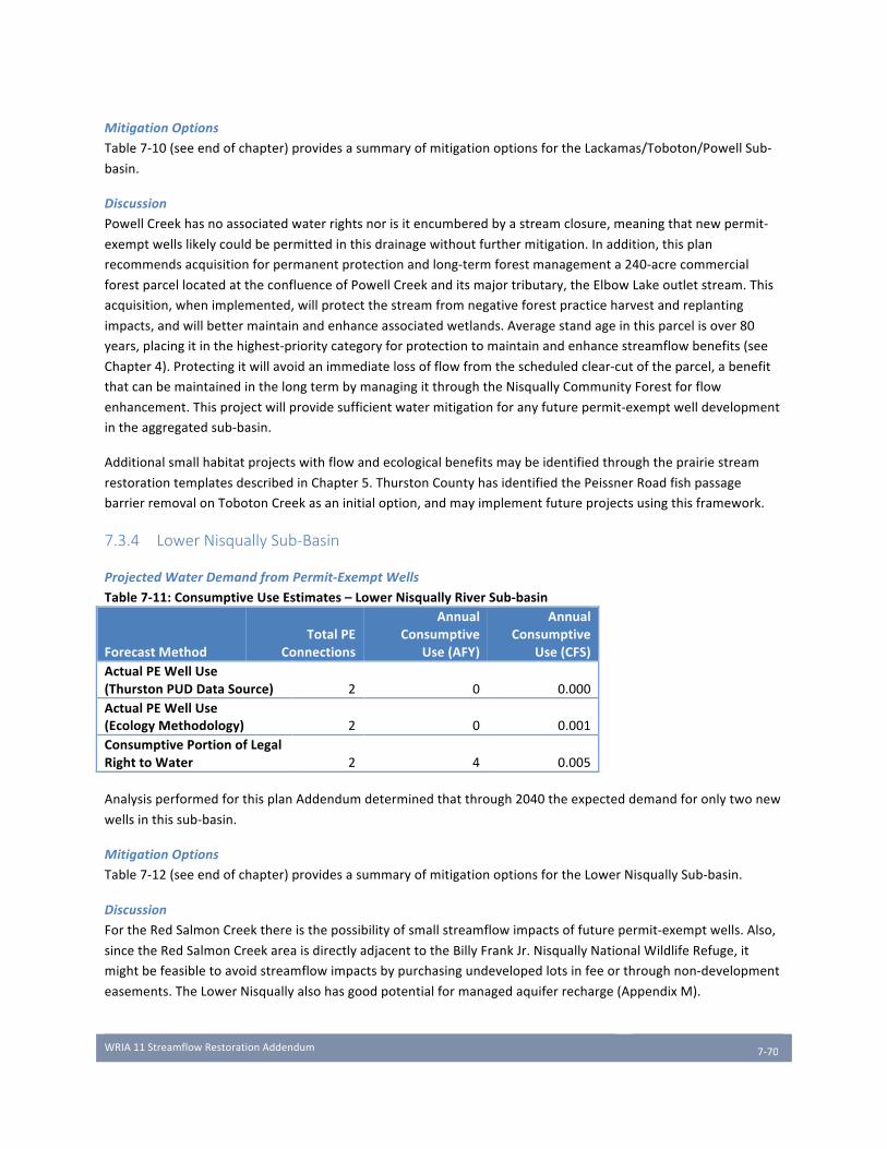
WRIA11StreamflowRestorationAddendum
7-70
MitigationOptions
Table7-10(seeendofchapter)providesasummaryofmitigationoptionsfortheLackamas/Toboton/PowellSub-
basin.
Discussion
PowellCreekhasnoassociatedwaterrightsnorisitencumberedbyastreamclosure,meaningthatnewpermit-
exemptwellslikelycouldbepermittedinthisdrainagewithoutfurthermitigation.Inaddition,thisplan
recommendsacquisitionforpermanentprotectionandlong-termforestmanagementa240-acrecommercial
forestparcellocatedattheconfluenceofPowellCreekanditsmajortributary,theElbowLakeoutletstream.This
acquisition,whenimplemented,willprotectthestreamfromnegativeforestpracticeharvestandreplanting
impacts,andwillbettermaintainandenhanceassociatedwetlands.Averagestandageinthisparcelisover80
years,placingitinthehighest-prioritycategoryforprotectiontomaintainandenhancestreamflowbenefits(see
Chapter4).Protectingitwillavoidanimmediatelossofflowfromthescheduledclear-cutoftheparcel,abenefit
thatcanbemaintainedinthelongtermbymanagingitthroughtheNisquallyCommunityForestforflow
enhancement.Thisprojectwillprovidesufficientwatermitigationforanyfuturepermit-exemptwelldevelopment
intheaggregatedsub-basin.
Additionalsmallhabitatprojectswithflowandecologicalbenefitsmaybeidentifiedthroughtheprairiestream
restorationtemplatesdescribedinChapter5.ThurstonCountyhasidentifiedthePeissnerRoadfishpassage
barrierremovalonTobotonCreekasaninitialoption,andmayimplementfutureprojectsusingthisframework.
7.3.4 Lower Nisqually Sub-Basin
ProjectedWaterDemandfromPermit-ExemptWells
Table7-11:ConsumptiveUseEstimates–LowerNisquallyRiverSub-basin
ForecastMethodTotalPE
Connections
AnnualConsumptive
Use(AFY)
AnnualConsumptive
Use(CFS)ActualPEWellUse(ThurstonPUDDataSource) 2 0 0.000ActualPEWellUse(EcologyMethodology) 2 0 0.001ConsumptivePortionofLegalRighttoWater 2 4 0.005
AnalysisperformedforthisplanAddendumdeterminedthatthrough2040theexpecteddemandforonlytwonew
wellsinthissub-basin.
MitigationOptions
Table7-12(seeendofchapter)providesasummaryofmitigationoptionsfortheLowerNisquallySub-basin.
Discussion
FortheRedSalmonCreekthereisthepossibilityofsmallstreamflowimpactsoffuturepermit-exemptwells.Also,
sincetheRedSalmonCreekareaisdirectlyadjacenttotheBillyFrankJr.NisquallyNationalWildlifeRefuge,it
mightbefeasibletoavoidstreamflowimpactsbypurchasingundevelopedlotsinfeeorthroughnon-development
easements.TheLowerNisquallyalsohasgoodpotentialformanagedaquiferrecharge(AppendixM).
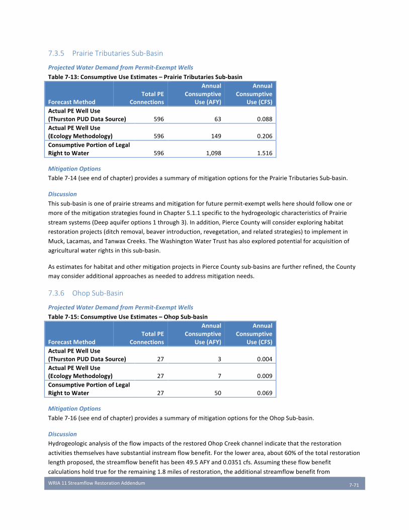
WRIA11StreamflowRestorationAddendum
7-71
7.3.5 Prairie Tributaries Sub-Basin
ProjectedWaterDemandfromPermit-ExemptWells
Table7-13:ConsumptiveUseEstimates–PrairieTributariesSub-basin
ForecastMethodTotalPE
Connections
AnnualConsumptive
Use(AFY)
AnnualConsumptive
Use(CFS)ActualPEWellUse(ThurstonPUDDataSource) 596 63 0.088ActualPEWellUse(EcologyMethodology) 596 149 0.206ConsumptivePortionofLegalRighttoWater 596 1,098 1.516
MitigationOptions
Table7-14(seeendofchapter)providesasummaryofmitigationoptionsforthePrairieTributariesSub-basin.
Discussion
Thissub-basinisoneofprairiestreamsandmitigationforfuturepermit-exemptwellshereshouldfollowoneor
moreofthemitigationstrategiesfoundinChapter5.1.1specifictothehydrogeologiccharacteristicsofPrairie
streamsystems(Deepaquiferoptions1through3).Inaddition,PierceCountywillconsiderexploringhabitat
restorationprojects(ditchremoval,beaverintroduction,revegetation,andrelatedstrategies)toimplementin
Muck,Lacamas,andTanwaxCreeks.TheWashingtonWaterTrusthasalsoexploredpotentialforacquisitionof
agriculturalwaterrightsinthissub-basin.
AsestimatesforhabitatandothermitigationprojectsinPierceCountysub-basinsarefurtherrefined,theCounty
mayconsideradditionalapproachesasneededtoaddressmitigationneeds.
7.3.6 Ohop Sub-Basin
ProjectedWaterDemandfromPermit-ExemptWells
Table7-15:ConsumptiveUseEstimates–OhopSub-basin
ForecastMethodTotalPE
Connections
AnnualConsumptive
Use(AFY)
AnnualConsumptive
Use(CFS)ActualPEWellUse(ThurstonPUDDataSource) 27 3 0.004ActualPEWellUse(EcologyMethodology) 27 7 0.009ConsumptivePortionofLegalRighttoWater 27 50 0.069
MitigationOptions
Table7-16(seeendofchapter)providesasummaryofmitigationoptionsfortheOhopSub-basin.
Discussion
HydrogeologicanalysisoftheflowimpactsoftherestoredOhopCreekchannelindicatethattherestoration
activitiesthemselveshavesubstantialinstreamflowbenefit.Forthelowerarea,about60%ofthetotalrestoration
lengthproposed,thestreamflowbenefithasbeen49.5AFYand0.0351cfs.Assumingtheseflowbenefit
calculationsholdtruefortheremaining1.8milesofrestoration,theadditionalstreamflowbenefitfrom
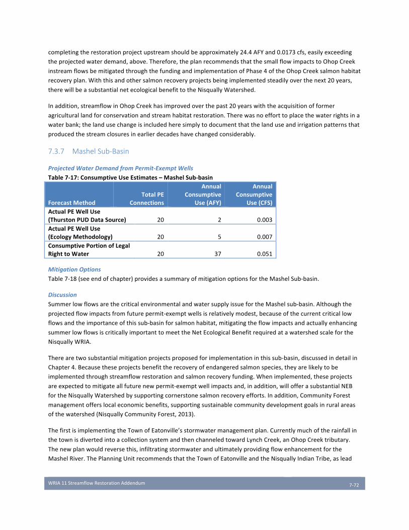
WRIA11StreamflowRestorationAddendum
7-72
completingtherestorationprojectupstreamshouldbeapproximately24.4AFYand0.0173cfs,easilyexceeding
theprojectedwaterdemand,above.Therefore,theplanrecommendsthatthesmallflowimpactstoOhopCreek
instreamflowsbemitigatedthroughthefundingandimplementationofPhase4oftheOhopCreeksalmonhabitat
recoveryplan.Withthisandothersalmonrecoveryprojectsbeingimplementedsteadilyoverthenext20years,
therewillbeasubstantialnetecologicalbenefittotheNisquallyWatershed.
Inaddition,streamflowinOhopCreekhasimprovedoverthepast20yearswiththeacquisitionofformer
agriculturallandforconservationandstreamhabitatrestoration.Therewasnoefforttoplacethewaterrightsina
waterbank;thelandusechangeisincludedheresimplytodocumentthatthelanduseandirrigationpatternsthat
producedthestreamclosuresinearlierdecadeshavechangedconsiderably.
7.3.7 Mashel Sub-Basin
ProjectedWaterDemandfromPermit-ExemptWells
Table7-17:ConsumptiveUseEstimates–MashelSub-basin
ForecastMethodTotalPE
Connections
AnnualConsumptive
Use(AFY)
AnnualConsumptive
Use(CFS)ActualPEWellUse(ThurstonPUDDataSource) 20 2 0.003ActualPEWellUse(EcologyMethodology) 20 5 0.007ConsumptivePortionofLegalRighttoWater 20 37 0.051
MitigationOptions
Table7-18(seeendofchapter)providesasummaryofmitigationoptionsfortheMashelSub-basin.
Discussion
SummerlowflowsarethecriticalenvironmentalandwatersupplyissuefortheMashelsub-basin.Althoughthe
projectedflowimpactsfromfuturepermit-exemptwellsisrelativelymodest,becauseofthecurrentcriticallow
flowsandtheimportanceofthissub-basinforsalmonhabitat,mitigatingtheflowimpactsandactuallyenhancing
summerlowflowsiscriticallyimportanttomeettheNetEcologicalBenefitrequiredatawatershedscaleforthe
NisquallyWRIA.
Therearetwosubstantialmitigationprojectsproposedforimplementationinthissub-basin,discussedindetailin
Chapter4.Becausetheseprojectsbenefittherecoveryofendangeredsalmonspecies,theyarelikelytobe
implementedthroughstreamflowrestorationandsalmonrecoveryfunding.Whenimplemented,theseprojects
areexpectedtomitigateallfuturenewpermit-exemptwellimpactsand,inaddition,willofferasubstantialNEB
fortheNisquallyWatershedbysupportingcornerstonesalmonrecoveryefforts.Inaddition,CommunityForest
managementofferslocaleconomicbenefits,supportingsustainablecommunitydevelopmentgoalsinruralareas
ofthewatershed(NisquallyCommunityForest,2013).
ThefirstisimplementingtheTownofEatonville’sstormwatermanagementplan.Currentlymuchoftherainfallin
thetownisdivertedintoacollectionsystemandthenchanneledtowardLynchCreek,anOhopCreektributary.
Thenewplanwouldreversethis,infiltratingstormwaterandultimatelyprovidingflowenhancementforthe
MashelRiver.ThePlanningUnitrecommendsthattheTownofEatonvilleandtheNisquallyIndianTribe,aslead
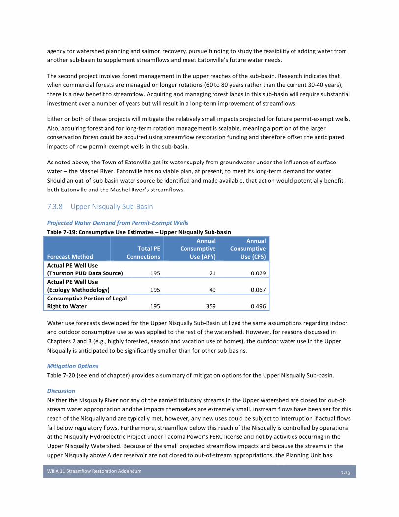
WRIA11StreamflowRestorationAddendum
7-73
agencyforwatershedplanningandsalmonrecovery,pursuefundingtostudythefeasibilityofaddingwaterfrom
anothersub-basintosupplementstreamflowsandmeetEatonville’sfuturewaterneeds.
Thesecondprojectinvolvesforestmanagementintheupperreachesofthesub-basin.Researchindicatesthat
whencommercialforestsaremanagedonlongerrotations(60to80yearsratherthanthecurrent30-40years),
thereisanewbenefittostreamflow.Acquiringandmanagingforestlandsinthissub-basinwillrequiresubstantial
investmentoveranumberofyearsbutwillresultinalong-termimprovementofstreamflows.
Eitherorbothoftheseprojectswillmitigatetherelativelysmallimpactsprojectedforfuturepermit-exemptwells.
Also,acquiringforestlandforlong-termrotationmanagementisscalable,meaningaportionofthelarger
conservationforestcouldbeacquiredusingstreamflowrestorationfundingandthereforeoffsettheanticipated
impactsofnewpermit-exemptwellsinthesub-basin.
Asnotedabove,theTownofEatonvillegetitswatersupplyfromgroundwaterundertheinfluenceofsurface
water–theMashelRiver.Eatonvillehasnoviableplan,atpresent,tomeetitslong-termdemandforwater.
Shouldanout-of-sub-basinwatersourcebeidentifiedandmadeavailable,thatactionwouldpotentiallybenefit
bothEatonvilleandtheMashelRiver’sstreamflows.
7.3.8 Upper Nisqually Sub-Basin
ProjectedWaterDemandfromPermit-ExemptWells
Table7-19:ConsumptiveUseEstimates–UpperNisquallySub-basin
ForecastMethodTotalPE
Connections
AnnualConsumptive
Use(AFY)
AnnualConsumptive
Use(CFS)ActualPEWellUse(ThurstonPUDDataSource) 195 21 0.029ActualPEWellUse(EcologyMethodology) 195 49 0.067ConsumptivePortionofLegalRighttoWater 195 359 0.496
WateruseforecastsdevelopedfortheUpperNisquallySub-Basinutilizedthesameassumptionsregardingindoor
andoutdoorconsumptiveuseaswasappliedtotherestofthewatershed.However,forreasonsdiscussedin
Chapters2and3(e.g.,highlyforested,seasonandvacationuseofhomes),theoutdoorwateruseintheUpper
Nisquallyisanticipatedtobesignificantlysmallerthanforothersub-basins.
MitigationOptions
Table7-20(seeendofchapter)providesasummaryofmitigationoptionsfortheUpperNisquallySub-basin.
Discussion
NeithertheNisquallyRivernoranyofthenamedtributarystreamsintheUpperwatershedareclosedforout-of-
streamwaterappropriationandtheimpactsthemselvesareextremelysmall.Instreamflowshavebeensetforthis
reachoftheNisquallyandaretypicallymet,however,anynewusescouldbesubjecttointerruptionifactualflows
fallbelowregulatoryflows.Furthermore,streamflowbelowthisreachoftheNisquallyiscontrolledbyoperations
attheNisquallyHydroelectricProjectunderTacomaPower’sFERClicenseandnotbyactivitiesoccurringinthe
UpperNisquallyWatershed.Becauseofthesmallprojectedstreamflowimpactsandbecausethestreamsinthe
upperNisquallyaboveAlderreservoirarenotclosedtoout-of-streamappropriations,thePlanningUnithas

WRIA11StreamflowRestorationAddendum
7-74
determinedthereisnoneedformitigationtooffsetfuturepermit-exemptwelluseintheUpperNisquallysub-
basinbeyondanyLewisandPierceCountypoliciesiftheyarefurtherdevelopedasLewisCountyparticipatesin
StreamflowRestorationandEnhancementprocessesinotherwatersheds,particularlyWRIA23,theUpper
ChehalisandPierceCountyparticipatesinWRIAs10,12and15.
7.4 Limitations and Uncertainty Scheduleandresourceconstraintslimitedtheabilitytoconductdetailedanalysesofmanyoftheidentified
mitigationopportunitiesinWRIA11,whichledtoincreaseduncertainty.RCW90.94.020requiresastrict
timeframe(February1,2019)foradoptionoftheWRIA11WatershedPlanupdate,leavingonlyafewmonthsto
identifyprojectsandconductthetechnicalanalysestoquantifynetecologicalbenefitsusedtodevelopthe
preliminarydraftoftheWRIA11WatershedPlanupdate.
Severalsourcesofuncertaintyaffectthequantificationofconsumptiveusefrompermit-exemptwellsaswellas
theabilityofprojectsandactionsintendedtomitigatethoseimpacts,including:
• Uncertaintyinnumber,spatialdistribution,andtimingofconsumptiveuseassociatedwithfuturepermit-exemptwellsandtheiractualimpactonstreamflow
• Uncertaintyinmagnitude,spatialdistribution,andtimingofoffsetsfrommitigationactions
• Uncertaintyregardinglandacquisitionandaccesstobuildprojects
• Uncertaintyregardingpermittingandregulatoryactions
• Uncertaintyinobtainingfunding,implementation,effectivenessandpermanenceofmitigationactions
• Uncertaintyregardingtheunderlyingassumptionsandanalysismethodsusedtoquantifyconsumptiveuseandtheeffectivenessofmitigationactions.
Totheextentthatmitigationactionshavebeenquantified,mostoftheoffsetsareassociatedwithprojectsthat
areinconceptualorpreliminarystatusandthusofferalowerlevelofimplementationandeffectivenesscertainty.
Theprojectlisthasbeenrecentlydeveloped,thelevelofdetailavailablevariesbyproject,andinformationabout
projectbenefitsisespeciallylimitedforconceptualprojects.
Severaloftheprojectsarenon-wateroffsetthatprovideecologicalbenefitsthatarequalitativeratherthan
quantitative.Severalofthewater-offsetprojects,suchasreplacingshallowwellswithdeeperwellsormanaged
aquiferrechargearedependentonhydrogeologyandsite-specificcharacteristicsthatcannotbeevaluatedwithout
site-specificinformationataprojectlevel.Thereisuncertaintyinprojectlocationsandwhentheycouldbebuilt.
Finally,thereisahighdegreeofuncertaintythatmitigationoffsetswillbesuccessful,especiallyforconceptual
projects,duetouncertainfundingsourcesandfeasibility.
Analysismethodsalsointroduceuncertaintiesintothecalculationofthevolume,locationandmagnitudeof
consumptiveuseimpactsandoffsets.Valuesforconsumptionandmitigationweredeterminedusingassumptions
andmodelsandarebasedonannualaverageswhicharelikelydifferentthanseasonalvalues.Althoughthevalues
generatedcanbeconsideredreasonableestimates,modelresultshavelimitationsandpotentiallyahighdegreeof
uncertainty.Anotherpotentialsourceofuncertaintyistheassumptionthatgroundwaterwithdrawalswillonly
impactstreamsinthesub-basintheyoccur.Althoughthisisgenerallysupported,impactscouldpropagateacross
sub-basins,orevenwatersheddivides.
Becauseoftheuncertaintyassociatedwithestimatingbothstreamflowimpactsandmitigationoffsets,consumptiveuseestimatescanbeconsideredmitigationtargets.Asprojectsarefundedandimplemented,this
WRIA11StreamflowRestorationAddendum
7-75
uncertaintywillbereducedthroughpermittracking,projectimplementation,sitecharacterization,datacollectionandmonitoring.Measurestodecreaseuncertaintyinclude:
• Buildingpermittrackingregardingnewpermit-exemptuses;• Monitoringtoassesspermit-exemptwateruse,climate,groundwaterlevelsandstreamflow;• Continuingtoidentifymitigationprojectsandopportunitiesthattotalmorethantheestimated
consumptiveusemitigationtargettocreateabuffertoensurethatmitigationprojectsareadequatetocoveractualconsumptiveuses;
• Adoptingpoliciesandmanagementprogramsthat:o Adequatelytracknewpermit-exemptuses;o Secureadequatefundingforbuilding,monitoringandmaintainingprojects;o Avoidorminimizeconsumptiveuseimpactssuchasreducingwithdrawalsandwater
conservation;o Conductingadequatesitecharacterizationatprojectlocations;o Meteringasneeded,andmonitoringwhereappropriate;o Reduceuncertaintyinprojectimplementationandeffectivenessbyusingadaptivemanagement
programsthatadjusttofutureconditionsandfactorsthroughpotentialtrackingandmonitoring.
TrackingandmonitoringofmitigationoffsetsareaddressedinChapter8andwillbefurtherexploredbythe
PlanningUnitinconcertwiththeDepartmentofEcologyaspartoftheAdaptiveManagementprocess.

MitigationStrategy Description Sub-Basin(s)TimingofBenefits ProjectAssumptions
AnnualAFBenefit(AF)
MIN
AnnualAFBenefit(AF)
MAX
StreamflowBenefit(cfs)
MIN
StreamflowBenefit(cfs)
MAXEcologicalBenefits Uncertainties Reference
YelmOffsetAction1
ConnectnewdevelopmentinYelmUGAtoCitywaterserviceusing
deepwell
Thompson/Yelm Year-Round
TheconsumptiveuseportionforeachnewP-Eusewouldbereduced,dependingonlocationanddepth(upto0.249AFperconnection).
240.5 240.5 0.33 0.33Streamflowincreasesequal
totheamountofconsumptivewatersaved.
Waterrightpermitting Section5.1.1AppendixL
UpperNisquallySub-basinregulatorystatus
Mitigationnotrequiredbecausesub-basinisnot
closedandISFsarenormallymet
UpperNisqually Year-Round 49Acre-Feet 49 49 0.067 0.067Droughtconditions
couldresultinISFsnotbeingmet
Section3.3.8AppendixB
DeepGroundwaterOption1
CompletenewP-Ewellsonlyindeeperaquifers
AllSubBasins Year-round
TheconsumptiveuseportionforeachnewP-Eusewouldbereduced,dependingonlocationanddepth(upto0.249AFperconnection).
Streamflowincreasesequaltotheamountof
consumptivewatersaved.
Funding,regulations,quantifyingvolumeand
timingofactualbenefits
Section5.1.1
DeepGroundwaterOption2
ReplaceshallowP-Ewellwithdrawalswith
withdrawalsfromdeeperaquifers
PrairieTributariesThompson/Yelm
Lackamas/Toboton/PowellYear-round
TheconsumptiveuseportionforeachP-Eusethatisreplaced(0.249AFper
connection).
Streamflowincreasesequaltotheamountof
consumptivewatersaved.
Permitting,quantificationof
impactsandbenefitsSection5.1.1
DeepGroundwaterOption3
DeepenPUD-managedGroupAwatersystem
groundwaterwithdrawals.
PrairieTributariesThompson/Yelm
Lackamas/Toboton/PowellYear-round
TheconsumptiveuseportionfortheGroupAusewouldbe
reduced,dependingonlocationanddepth(upto0.249AF/connection).
Streamflowincreasesequaltotheamountof
consumptivewatersaved.
Funding,hydrologicconditions
Section5.1.1
WaterRightAcquisition Purchaseandretirewaterrights
PrairieTributaries IrrigationseasonWaterrightspecific-Tier1
only 0 673 0 0.93Streamflowincreasesequal
totheamountofconsumptivewatersaved.
Fundingforanalysesandpurchases,consumptiveuse
volumes,waterrightownerwillingnessto
sell.
Section5.1.2AppendixK
YelmOffsetAction2ConnectingexistingPermit-ExemptusestoYelm's
waterserviceThompson/Yelm Year-round
10%ofexistingwellsreplaced,consumptiveuseportioniscredited(0.249AF
perconnection).10.4 10.4 0.014 0.014
Streamflowincreasesequaltotheamountof
consumptivewatersaved.
Assume10%ofexistingwellsinservicearea,fundingpermitting
Section5.1.1
YelmOffsetAction3InfiltrationofreclaimedClassAwatertoprovide
mitigationThompson/Yelm Year-round
Additionalrechargeofreclaimedwater 87 400 0.12 0.552
Streamflowincreasesequaltotheamountofreclaimedwaterdischargedtothe
shallowaquifer.
Funding,permitting,reclaimedwater
volume,site-specificfactors
Section5.1.1
PierceCountyStreamRestoration
Ditchremovalwithoffchannelstorage,Beaverreintroduction,floodplainreconnetionandstream
meandering,re-vegetation
PrairieTributaries Year-round Assume0.0096cfs/mileoflinearchanneland6-60miles 41.7 417 0.0576 0.576
Increasegroundwaterstorageinfloodplain,
increasedin-streamhabitat,waterqualityimprovements,increasedstreamflowduringlowflow/intermittentflow
season.
Funding,landavailabilityandaccess,
limiteddataonpotentiallyrestorableareasandhydrologic
conditions
Section5.1.4Table5-6AppendixE
ThurstonCountyStreamRestoration-Thompson/Yelm
Ditchremovalwithoffchannelstorage,Beaverreintroduction,floodplainreconnetionandstream
meandering,re-vegetation
Thompson/Yelm Year-roundAssume0.0096cfs/mileoflinearchanneland1.6-16
miles11.12 111.2 0.01536 0.1536
Increasegroundwaterstorageinfloodplain,
increasedin-streamhabitat,waterqualityimprovements,increasedstreamflowduringlowflow/intermittentflow
season.
Funding,landavailabilityandaccess,
limiteddataonpotentiallyrestorableareasandhydrologic
conditions
Section5.1.4Table5-6AppendixE
ThurstonCountyStreamRestoration-Lackamas/Toboton/
Powell
Ditchremovalwithoffchannelstorage,Beaverreintroduction,floodplainreconnetionandstream
meandering,re-vegetation
Lackamas/Toboton/Powell Year-roundAssume0.0096cfs/mileoflinearchanneland.23-2.3
miles1.6 15.9 0.002208 0.02208
Increasegroundwaterstorageinfloodplain,
increasedin-streamhabitat,waterqualityimprovements,increasedstreamflowduringlowflow/intermittentflow
season.
Funding,landavailabilityandaccess,
limiteddataonpotentiallyrestorableareasandhydrologic
conditions
Section5.1.4Table5-6AppendixE
ManagedAquiferRecharge
Diversionofhigherwinterstreamflowforinfiltration
andstorage
Mashel,Ohop,PrairieTribs,UpperNisqually,Lower
NisquallySummer-Fall
ProjectSpecific-assume0-5projectsin5sub-basins@200AFperprojectand6
monthbenefit
0 1000 0 2.7626 Reductioninhighflows,increasesinlowflows
Landavailability,funding,permitting,waterquality,sitespecificfactors
Secton5.1.3AppendixM
BarrierRemovalProjects
CulvertReplacement Lackamas/Toboton/Powell Year-roundPeissnerRoadProject
3.03Acre-Feet(0.0023cfs) 1.67 1.67 0.0023 0.0023 Re-openstreamreaches&habitat,increaselowflows
Funding,analyses,permitting
Section5.1.4Table5-6
MashelWatershedCommunityForest
ForestManagement,protection,acquisition,
restorationMashel Year-round
rateofpurchaseislinearandbeginsinyear1-and
compounds1699 3798 2.347 5.246
Streamflow,habitat,ecosystembenefits,woodydebrisandsedimentsupply,
erosioncontrol
Funding,modelinguncertainties
Section4.2.1Tables4-2and4-3
AppendixG
EatonvilleCapitalImprovementProjects
Implementationofhighestprioritystormwatercomprehensiveplan
projects
Mashel/Ohop(1) Summer-Fall 0.659-1.843AFY(2) 38.7 38.7 0.128 0.128 Increasedstreamflow,improvedwaterquality
Funding,modelinguncertainties
Section4.2.2Table4-4AppendixH
EatonvilleWaterSystemConservation
Leakdetectionandrepair Mashel Year-round N/A 69.35 69.35 0.096 0.096 Increasedstreamflow Funding,unauthorizedwateruses
Section4.2.2Table4-4AppendixI
EatonvilleASR
Capturehighwinterflows,rechargeandstoreinthe
volcanicaquiferforrecoveryduringhigh-
demandseason
Mashel Summer-Fall 20-80Acre-Feet(2) 20 80 0.11 0.45 Increasedstreamflow
Funding,aquiferhydraulicproperties,groundwaterquality,abilitytostorewater,
impactsduringrecovery
Section4.2.2Table4-4AppendixH
EatonvilleAlternativeWaterSupply
RelocateEatonville'swaterintakefromMashelRiverneartowntomouthof
MashelRiverorAlderLake
Mashel Summer 95Acre-Feet(0.8cfs) 95 95 0.8 0.8 IncreasedstreamflowFunding,property
ownership,right-of-wayaccess,waterquality
Section4.2.2Table4-4
(Golder,2010)
OhopPhaseIVFloodplainRestoration
&Protection
Floodplainreconnectionandstreammeandering,engineeredlogjams,re-
vegetation
Ohop Year-round 24.4Acre-Feet/yr 24.4 24.4 0.0173 0.0173
Increasegroundwaterstorageinfloodplain,
increasedin-streamhabitat,waterqualityimprovements,increasedstreamflowduring
lowflowseason.
Projectfundingandlandsecured-low
uncertainty
Section4.2.3Table4-5AppendixE
OhopWatershedRecovery/Community
Forest
ForestManagement,protection,acquisition,
restorationOhop Year-round
rateofpurchaseislinear,benefitsarenon-linear-beginsinyear1-and
compounds
0 1112 0 1.5356Streamflow,habitat,
ecosystembenefits,woodydebrisandsedimentsupply,
erosioncontrol
Funding,modelinguncertainties
Section4.2.1Tables4-2and4-3
AppendixG
BaldHillsWatershedRecovery/Community
Forest
ForestManagement,protection,acquisition,
restorationToboton/Lackamas/Powell Year-round
rateofpurchaseislinear,benefitsarenon-linear-beginsinyear1-and
compounds
80.9 487 0.1117 0.6727Streamflow,habitat,
ecosystembenefits,woodydebrisandsedimentsupply,
erosioncontrol
Funding,modelinguncertainties
Section4.2.1Tables4-2and4-3
AppendixG
UpperNisquallyRecovery/Community
Forest
ForestManagement,protection,acquisition,
restorationUpperNisqually Year-round
rateofpurchaseislinear,benefitsarenon-linear-beginsinyear1-and
compounds
0 0Streamflow,habitat,
ecosystembenefits,woodydebrisandsedimentsupply,
erosioncontrol
Funding,modelinguncertainties
Section4.2.1Tables4-2and4-3
AppendixG
2470 8623 4.22 14.361AllEatonvilleCIPProjectsareaccountedforinMashelSub-basin(InactualityCIP1&2areinMashel;3&4areinOhop;5&6areonthedividebetweenthetwosub-basins)2Seasonalflowbenefitonly.CFSshowsmaximumseasonalbenefit;AnnualAFshowstotalbenefitaveragedoveroneyear.SeeChapter4andAppendicesforassumptions.
Table7-2:SummaryofWRIA11WatershedMitigationOptions
MicroM
itigatio
nSub-Ba
sinStrategies
Salmon
RecoveryStrategies
Deman
dRe
duction
TOTAL

WRIA11StreamflowRestorationAddendum
7-77
Table7-6:McAllisterSub-BasinMitigation
MitigationStrategy Description
TimingofBenefits ProjectAssumptions
AnnualBenefit(AF)MIN
AnnualBenefit(AF)MAX
FlowBenefit(cfs)MIN
FlowBenefit(cfs)MAX EcologicalBenefits Uncertainties
DeepGroundwaterOption1
CompletenewP-E
wellsonlyindeeper
aquifers
Year-round
Theconsumptiveuseportionfor
eachnewP-Eusewouldbe
reduced,dependingonlocation
anddepth(upto0.249AFper
connection).
TBD TBD TBD TBD
Streamflowincreases
equaltotheamountof
consumptivewater
saved.
Funding,regulations,
quantifyingvolumeand
timingofactualbenefits
DeepGroundwaterOption2
ReplaceshallowP-E
wellwithdrawals
withwithdrawals
fromdeeper
aquifers
Year-round
Theconsumptiveuseportionfor
eachP-Eusethatisreplaced
(0.249AFperconnection).
TBD TBD TBD TBD
Streamflowincreases
equaltotheamountof
consumptivewater
saved.
Permitting,
quantificationof
impactsandbenefits
DeepGroundwaterOption3
DeepenPUD-
managedGroupA
watersystem
groundwater
withdrawals.
Year-round
Theconsumptiveuseportionfor
theGroupAusewouldbe
reduced,dependingonlocation
anddepth(upto0.249
AF/connection).
TBD TBD TBD TBD
Streamflowincreases
equaltotheamountof
consumptivewater
saved.
Funding,hydrologic
conditions
TOTALMitigation TBD TBD TBD TBD ActualConsumptiveUse(ECYmethod,AFY):39
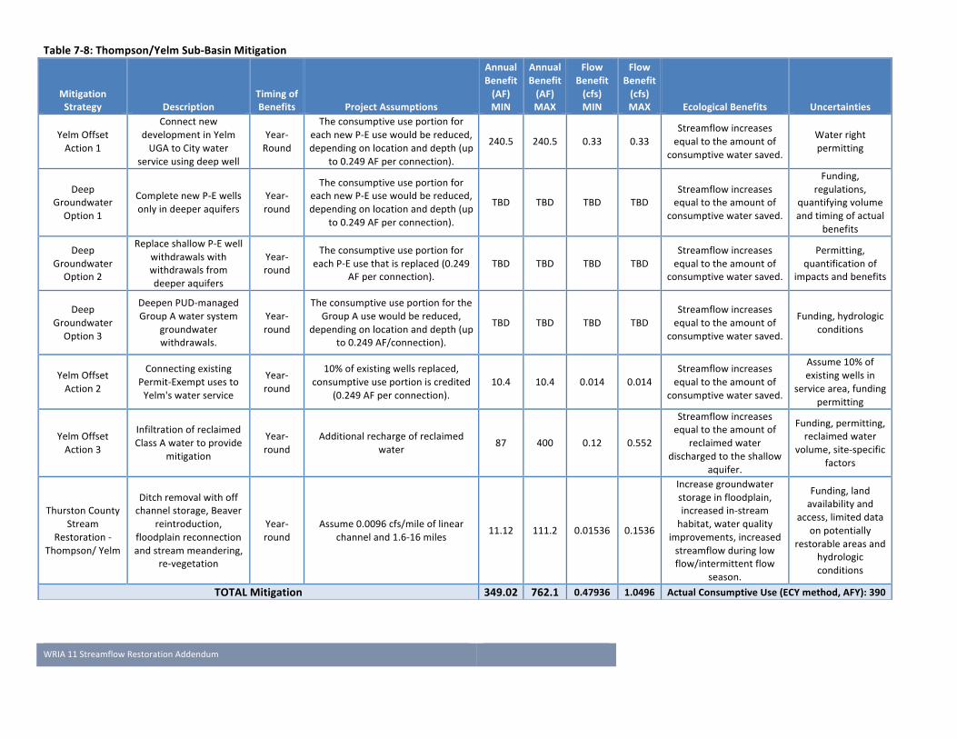
WRIA11StreamflowRestorationAddendum
7-78
Table7-8:Thompson/YelmSub-BasinMitigation
MitigationStrategy Description
TimingofBenefits ProjectAssumptions
AnnualBenefit(AF)MIN
AnnualBenefit(AF)MAX
FlowBenefit(cfs)MIN
FlowBenefit(cfs)MAX EcologicalBenefits Uncertainties
YelmOffset
Action1
Connectnew
developmentinYelm
UGAtoCitywater
serviceusingdeepwell
Year-
Round
Theconsumptiveuseportionfor
eachnewP-Eusewouldbereduced,
dependingonlocationanddepth(up
to0.249AFperconnection).
240.5 240.5 0.33 0.33
Streamflowincreases
equaltotheamountof
consumptivewatersaved.
Waterright
permitting
Deep
Groundwater
Option1
CompletenewP-Ewells
onlyindeeperaquifers
Year-
round
Theconsumptiveuseportionfor
eachnewP-Eusewouldbereduced,
dependingonlocationanddepth(up
to0.249AFperconnection).
TBD TBD TBD TBD
Streamflowincreases
equaltotheamountof
consumptivewatersaved.
Funding,
regulations,
quantifyingvolume
andtimingofactual
benefits
Deep
Groundwater
Option2
ReplaceshallowP-Ewell
withdrawalswith
withdrawalsfrom
deeperaquifers
Year-
round
Theconsumptiveuseportionfor
eachP-Eusethatisreplaced(0.249
AFperconnection).
TBD TBD TBD TBD
Streamflowincreases
equaltotheamountof
consumptivewatersaved.
Permitting,
quantificationof
impactsandbenefits
Deep
Groundwater
Option3
DeepenPUD-managed
GroupAwatersystem
groundwater
withdrawals.
Year-
round
Theconsumptiveuseportionforthe
GroupAusewouldbereduced,
dependingonlocationanddepth(up
to0.249AF/connection).
TBD TBD TBD TBD
Streamflowincreases
equaltotheamountof
consumptivewatersaved.
Funding,hydrologic
conditions
YelmOffset
Action2
Connectingexisting
Permit-Exemptusesto
Yelm'swaterservice
Year-
round
10%ofexistingwellsreplaced,
consumptiveuseportioniscredited
(0.249AFperconnection).
10.4 10.4 0.014 0.014
Streamflowincreases
equaltotheamountof
consumptivewatersaved.
Assume10%of
existingwellsin
servicearea,funding
permitting
YelmOffset
Action3
Infiltrationofreclaimed
ClassAwatertoprovide
mitigation
Year-
round
Additionalrechargeofreclaimed
water87 400 0.12 0.552
Streamflowincreases
equaltotheamountof
reclaimedwater
dischargedtotheshallow
aquifer.
Funding,permitting,
reclaimedwater
volume,site-specific
factors
ThurstonCounty
Stream
Restoration-
Thompson/Yelm
Ditchremovalwithoff
channelstorage,Beaver
reintroduction,
floodplainreconnection
andstreammeandering,
re-vegetation
Year-
round
Assume0.0096cfs/mileoflinear
channeland1.6-16miles11.12 111.2 0.01536 0.1536
Increasegroundwater
storageinfloodplain,
increasedin-stream
habitat,waterquality
improvements,increased
streamflowduringlow
flow/intermittentflow
season.
Funding,land
availabilityand
access,limiteddata
onpotentially
restorableareasand
hydrologic
conditions
TOTALMitigation 349.02 762.1 0.47936 1.0496 ActualConsumptiveUse(ECYmethod,AFY):390
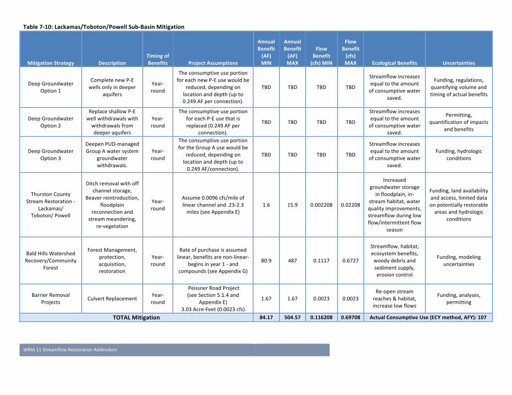
WRIA11StreamflowRestorationAddendum
7-79
Table7-10:Lackamas/Toboton/PowellSub-BasinMitigation
MitigationStrategy DescriptionTimingofBenefits ProjectAssumptions
AnnualBenefit(AF)MIN
AnnualBenefit(AF)MAX
FlowBenefit(cfs)MIN
FlowBenefit(cfs)MAX EcologicalBenefits Uncertainties
DeepGroundwater
Option1
CompletenewP-E
wellsonlyindeeper
aquifers
Year-
round
Theconsumptiveuseportion
foreachnewP-Eusewouldbe
reduced,dependingon
locationanddepth(upto
0.249AFperconnection).
TBD TBD TBD TBD
Streamflowincreases
equaltotheamount
ofconsumptivewater
saved.
Funding,regulations,
quantifyingvolumeand
timingofactualbenefits
DeepGroundwater
Option2
ReplaceshallowP-E
wellwithdrawalswith
withdrawalsfrom
deeperaquifers
Year-
round
Theconsumptiveuseportion
foreachP-Eusethatis
replaced(0.249AFper
connection).
TBD TBD TBD TBD
Streamflowincreases
equaltotheamount
ofconsumptivewater
saved.
Permitting,
quantificationofimpacts
andbenefits
DeepGroundwater
Option3
DeepenPUD-managed
GroupAwatersystem
groundwater
withdrawals.
Year-
round
Theconsumptiveuseportion
fortheGroupAusewouldbe
reduced,dependingon
locationanddepth(upto
0.249AF/connection).
TBD TBD TBD TBD
Streamflowincreases
equaltotheamount
ofconsumptivewater
saved.
Funding,hydrologic
conditions
ThurstonCounty
StreamRestoration-
Lackamas/
Toboton/Powell
Ditchremovalwithoff
channelstorage,
Beaverreintroduction,
floodplain
reconnectionand
streammeandering,
re-vegetation
Year-
round
Assume0.0096cfs/mileof
linearchanneland.23-2.3
miles(seeAppendixE)
1.6 15.9 0.002208 0.02208
Increased
groundwaterstorage
infloodplain,in-
streamhabitat,water
qualityimprovements,
streamflowduringlow
flow/intermittentflow
season
Funding,landavailability
andaccess,limiteddata
onpotentiallyrestorable
areasandhydrologic
conditions
BaldHillsWatershed
Recovery/Community
Forest
ForestManagement,
protection,
acquisition,
restoration
Year-
round
Rateofpurchaseisassumed
linear,benefitsarenon-linear-
beginsinyear1-and
compounds(seeAppendixG)
80.9 487 0.1117 0.6727
Streamflow,habitat,
ecosystembenefits,
woodydebrisand
sedimentsupply,
erosioncontrol
Funding,modeling
uncertainties
BarrierRemoval
Projects CulvertReplacementYear-
round
PeissnerRoadProject
(seeSection5.1.4and
AppendixE)
3.03Acre-Feet(0.0023cfs)
1.67 1.67 0.0023 0.0023
Re-openstream
reaches&habitat,
increaselowflows
Funding,analyses,
permitting
TOTALMitigation 84.17 504.57 0.116208 0.69708 ActualConsumptiveUse(ECYmethod,AFY):107
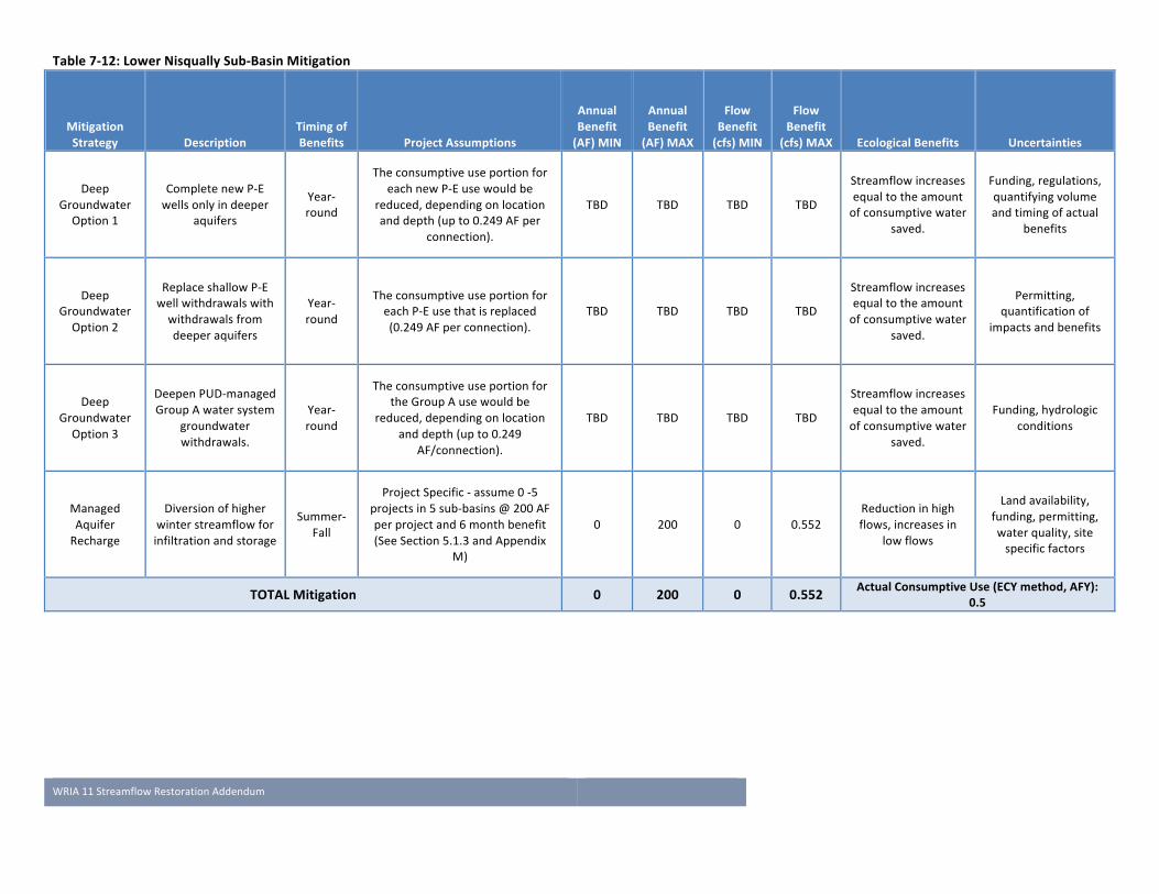
WRIA11StreamflowRestorationAddendum
7-80
Table7-12:LowerNisquallySub-BasinMitigation
MitigationStrategy Description
TimingofBenefits ProjectAssumptions
AnnualBenefit(AF)MIN
AnnualBenefit(AF)MAX
FlowBenefit(cfs)MIN
FlowBenefit
(cfs)MAX EcologicalBenefits Uncertainties
Deep
Groundwater
Option1
CompletenewP-E
wellsonlyindeeper
aquifers
Year-
round
Theconsumptiveuseportionfor
eachnewP-Eusewouldbe
reduced,dependingonlocation
anddepth(upto0.249AFper
connection).
TBD TBD TBD TBD
Streamflowincreases
equaltotheamount
ofconsumptivewater
saved.
Funding,regulations,
quantifyingvolume
andtimingofactual
benefits
Deep
Groundwater
Option2
ReplaceshallowP-E
wellwithdrawalswith
withdrawalsfrom
deeperaquifers
Year-
round
Theconsumptiveuseportionfor
eachP-Eusethatisreplaced
(0.249AFperconnection).
TBD TBD TBD TBD
Streamflowincreases
equaltotheamount
ofconsumptivewater
saved.
Permitting,
quantificationof
impactsandbenefits
Deep
Groundwater
Option3
DeepenPUD-managed
GroupAwatersystem
groundwater
withdrawals.
Year-
round
Theconsumptiveuseportionfor
theGroupAusewouldbe
reduced,dependingonlocation
anddepth(upto0.249
AF/connection).
TBD TBD TBD TBD
Streamflowincreases
equaltotheamount
ofconsumptivewater
saved.
Funding,hydrologic
conditions
Managed
Aquifer
Recharge
Diversionofhigher
winterstreamflowfor
infiltrationandstorage
Summer-
Fall
ProjectSpecific-assume0-5
projectsin5sub-basins@200AF
perprojectand6monthbenefit
(SeeSection5.1.3andAppendix
M)
0 200 0 0.552
Reductioninhigh
flows,increasesin
lowflows
Landavailability,
funding,permitting,
waterquality,site
specificfactors
TOTALMitigation 0 200 0 0.552 ActualConsumptiveUse(ECYmethod,AFY):0.5

WRIA11StreamflowRestorationAddendum
7-81
Table7-14:PrairieTributariesSub-BasinMitigation
MitigationStrategy Description
TimingofBenefits ProjectAssumptions
AnnualBenefit(AF)MIN
AnnualBenefit(AF)MAX
FlowBenefit(cfs)MIN
FlowBenefit(cfs)MAX EcologicalBenefits Uncertainties
Deep
Groundwater
Option1
CompletenewP-E
wellsonlyin
deeperaquifers
Year-round
Theconsumptiveuseportionfor
eachnewP-Eusewouldbereduced,
dependingonlocationanddepth
(upto0.249AFperconnection).
TBD TBD TBD TBD
Streamflowincreases
equaltotheamount
ofconsumptivewater
saved.
Funding,regulations,
quantifyingvolumeand
timingofactualbenefits
Deep
Groundwater
Option2
ReplaceshallowP-
Ewellwithdrawals
withwithdrawals
fromdeeper
aquifers
Year-round
Theconsumptiveuseportionfor
eachP-Eusethatisreplaced(0.249
AFperconnection).
TBD TBD TBD TBD
Streamflowincreases
equaltotheamount
ofconsumptivewater
saved.
Permitting,quantificationof
impactsandbenefits
Deep
Groundwater
Option3
DeepenPUD-
managedGroupA
watersystem
groundwater
withdrawals.
Year-round
Theconsumptiveuseportionforthe
GroupAusewouldbereduced,
dependingonlocationanddepth
(upto0.249AF/connection).
TBD TBD TBD TBD
Streamflowincreases
equaltotheamount
ofconsumptivewater
saved.
Funding,hydrologic
conditions
WaterRight
AcquisitionPurchaseand
retirewaterrights
Irrigation
season
Waterrightspecific-Tier1only
(SeeSection5.1.2)0 673 0 0.93
Streamflowincreases
equaltotheamount
ofconsumptivewater
saved.
Fundingforanalysesand
purchases,consumptiveuse
volumes,waterrightowner
willingnesstosell.
Managed
Aquifer
Recharge
Diversionof
higherwinter
streamflowfor
infiltrationand
storage
Summer-Fall
ProjectSpecific-assume0-5
projectsin5sub-basins@200AF
perprojectand6monthbenefit
(SeeSection5.1.3andAppendixM)
0 200 0 0.552
Reductioninhigh
flows,increasesinlow
flows
Landavailability,funding,
permitting,waterquality,
sitespecificfactors
PierceCounty
Stream
Restoration
Ditchremoval
withoffchannel
storage,Beaver
reintroduction,
floodplain
reconnectionand
stream
meandering,re-
vegetation
Year-round
Assume0.0096cfs/mileoflinear
channeland6-60miles(see
AppendixE)
41.7 417 0.0576 0.576
Increasegroundwater
storageinfloodplain,
increasedin-stream
habitat,waterquality
improvements,
increasedstreamflow
duringlow
flow/intermittentflow
season.
Funding,landavailabilityand
access,limiteddataon
potentiallyrestorableareas
andhydrologicconditions
TOTALMitigation 41.7 1290 0.0576 2.058 ActualConsumptiveUse(ECYmethod,AFY):149
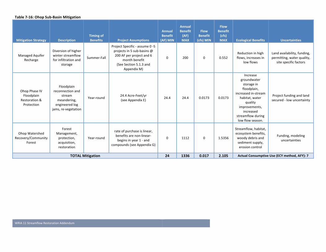
WRIA11StreamflowRestorationAddendum
7-82
Table7-16:OhopSub-BasinMitigation
MitigationStrategy DescriptionTimingofBenefits ProjectAssumptions
AnnualBenefit(AF)MIN
AnnualBenefit(AF)MAX
FlowBenefit(cfs)MIN
FlowBenefit(cfs)MAX EcologicalBenefits Uncertainties
ManagedAquifer
Recharge
Diversionofhigher
winterstreamflow
forinfiltrationand
storage
Summer-Fall
ProjectSpecific-assume0-5
projectsin5sub-basins@
200AFperprojectand6
monthbenefit
(SeeSection5.1.3and
AppendixM)
0 200 0 0.552
Reductioninhigh
flows,increasesin
lowflows
Landavailability,funding,
permitting,waterquality,
sitespecificfactors
OhopPhaseIV
Floodplain
Restoration&
Protection
Floodplain
reconnectionand
stream
meandering,
engineeredlog
jams,re-vegetation
Year-round24.4Acre-Feet/yr
(seeAppendixE)24.4 24.4 0.0173 0.0173
Increase
groundwater
storagein
floodplain,
increasedin-stream
habitat,water
quality
improvements,
increased
streamflowduring
lowflowseason.
Projectfundingandland
secured-lowuncertainty
OhopWatershed
Recovery/Community
Forest
Forest
Management,
protection,
acquisition,
restoration
Year-round
rateofpurchaseislinear,
benefitsarenon-linear-
beginsinyear1-and
compounds(seeAppendixG)
0 1112 0 1.5356
Streamflow,habitat,
ecosystembenefits,
woodydebrisand
sedimentsupply,
erosioncontrol
Funding,modeling
uncertainties
TOTALMitigation 24 1336 0.017 2.105 ActualConsumptiveUse(ECYmethod,AFY):7

WRIA11StreamflowRestorationAddendum
7-83
Table7-18:MashelSub-BasinMitigation
MitigationStrategy Description
TimingofBenefits ProjectAssumptions
AnnualBenefit(AF)MIN
AnnualBenefit(AF)MAX
FlowBenefit(cfs)MIN
FlowBenefit(cfs)MAX EcologicalBenefits Uncertainties
ManagedAquifer
Recharge
Diversionofhigher
winterstreamflow
forinfiltrationand
storage
Summer-Fall
ProjectSpecific-assume0-5
projectsin5sub-basins@200
AFperprojectand6month
benefit
0 200 0 0.552
Reductioninhigh
flows,increasesin
lowflows
Landavailability,
funding,
permitting,water
quality,sitespecific
factors
Mashel
Watershed
CommunityForest
ForestManagement,
protection,
acquisition,
restoration
Year-round
rateofpurchaseislinearand
beginsinyear1-and
compounds
1699 3798 2.35 5.25
Streamflow,
habitat,ecosystem
benefits,woody
debrisand
sedimentsupply,
erosioncontrol
Funding,modeling
uncertainties
EatonvilleCapital
Improvement
Projects
Implementationof
highestpriority
stormwater
comprehensiveplan
projects
Summer-Fall 0.659-1.843AFY 38.7 38.7 0.128 0.128
Increased
streamflow,
improvedwater
quality
Funding,modeling
uncertainties
EatonvilleWater
System
Conservation
Leakdetectionand
repairYear-round N/A 69.35 69.35 0.096 0.096
Increased
streamflow
Funding,
unauthorizedwater
uses
EatonvilleASR
Capturehighwinter
flows,rechargeand
storeinthevolcanic
aquiferforrecovery
duringhigh-demand
season
Summer-Fall 20-80Acre-Feet 20 80 0.11 0.45Increased
streamflow
Funding,aquifer
hydraulic
properties,
groundwater
quality,abilityto
storewater,
impactsduring
recovery
Eatonville
AlternativeWater
Supply
RelocateEatonville's
waterintakefrom
MashelRivernear
towntomouthof
MashelRiveror
AlderLake
Summer95Acre-Feet(0.8cfs)
SeeGolder(2010)95 95 0.8 0.8
Increased
streamflow
Funding,property
ownership,right-
of-wayaccess,
waterquality
TOTALMitigation 1922 4281 3.481 7.272 ActualConsumptiveUse(ECYmethod,AFY):5

WRIA11StreamflowRestorationAddendum
7-84
Table7-20:UpperNisquallySub-BasinMitigation
MitigationStrategy Description
TimingofBenefits ProjectAssumptions
AnnualBenefit(AF)MIN
AnnualBenefit(AF)MAX
FlowBenefit(cfs)MIN
FlowBenefit(cfs)MAX EcologicalBenefits Uncertainties
UpperNisqually
Sub-basin
regulatorystatus
Mitigationnot
requiredbecause
sub-basinisnot
closedandISFsare
normallymet
Year-Round 49Acre-Feet 49 49 0.067 0.067N/A(demand
reduction)
Droughtconditions
couldresultinISFs
notbeingmet
ManagedAquifer
Recharge
Diversionofhigher
winterstreamflow
forinfiltrationand
storage
Summer-Fall
ProjectSpecific-
assume0-5projects
in5sub-basins@200
AFperprojectand6
monthbenefit
(SeeSection5.1.3and
AppendixM)
0 200 0 0.552
Reductioninhigh
flows,increasesin
lowflows
Landavailability,
funding,permitting,
waterquality,site
specificfactors
TOTALMitigation 49 249 0.067 0.619 ActualConsumptiveUse(ECYmethod,AFY):49
WRIA11StreamflowRestorationAddendum
8-85
Chapter 8 Implementation and Adaptive Management
8.1 Implementation AlthoughactionfundingandimplementationisnotaddressedunderRCW90.94.020,itisincludedinthisAddendumintheformofnextsteps.ThissectionaddressesimplementationofthisWatershedPlanAddendumincludingpolicyrecommendationsandprojectactions;detailedimplementationofindividualactionswillbeaddressedthroughimplementationplansandimplementationmonitoring.
ImplementationoftheactivitiesspecifiedinthisNisquallyWatershedManagementPlanAddendum(Addendum)willcommencefollowingitsadoptionbyEcology.ThedeadlineforadoptionbyEcologyisFebruary1,2019,assetforthinRCW90.94.020(7)(b).TheprojectsandregulatoryprocessesconsideredinthisAddendumareinvariousstagesofdevelopment.AspartofImplementation,theNisquallyPlanningUnitwillcontinuetoworktogethertofurtherdevelopprojects(includingfeasibilitystudiesandadditionalstreamflowmodeling),assistCountygovernmentsasnecessaryinevaluatingpotentialchangestoregulatorypolicy,andgarnerfundingforimplementationafterthestatutorydeadlineforsubmittal.ItisassumedtheproposedprojectswillbefundedunderEcology’sStreamflowRestorationgrantsorSalmonRecoveryfunding.
WhilemostwatershedssubjecttotherequirementsoftheRCW90.94.020haveovertwoyearstorespondtotherequirementsoftheAct,theNisquallyWatershedPlanningUnithashadlessthaneightmonths.Therearethreecountieslocatedwithinthewatershedthatwillreviewandcouldpotentiallyimplementchangestotheircurrentbuildingapplicationprocesstoaddressruralwateruse.Duetotheshorttimeframe,somemitigationstrategiesthatarebeingdevelopedtooffsetpotentialstreamflowimpactsfrompermit-exemptwellwithdrawalsneedfurtherdevelopmentandquantificationafterthemandatedFebruary1,2019planupdate.Duringimplementation,thePlanningUnitmayrequestrule-makingtoaddressmodificationstothedomesticpermit-exemptwellconnectionfeesand/orthewaterusequantitiessetforthinRCW90.04.020(5)(f)thatareenactedthroughEcology.
Thurston,PierceandLewisCountiesarecontinuingtoexploreregulatorystrategiestooffsetpermit-exemptwellimpacts,ifadditionalmitigationbeyondstreamflowandhabitatprojectsisdeterminedtobenecessary.ThesestrategieswillbeappliedandfurtherdevelopedforotherwatershedsintheirresponsestoRCW90.94.020andRCW90.94.030.ThurstonCountywillbeapplyingmethodologyfromtheNisquallyprocesstoWRIAs13,14,22and23;PierceCountytoWRIAs10,12and15;andLewisCountytoWRIAs13and23.ThePlanningUnithasstructuredanadaptivemanagementapproachthatwillcontinueafterFebruary1,2019toenableImplementingGovernmentstofullydevelopmitigationactionsandimplementpotentialcodeorordinancechangesinparallelwithotherwatersheds.Detailedevaluationofhabitatprojectsandtechnologiesthatwillmorespecificallyquantifystreamflowbenefitswillalsooccurduringthisadaptivemanagementperiod.Section8.2belowaddressesthePlanningUnit’sadaptivemanagementapproach.
ThePlanningUnitiscurrentlydiscussingseveralactionsthatwouldrequirefuturerule-making.AtthistimethereisconsensusonthePlanningUnittomaintainflexibilityuntiltheseoptionscanbefurtherexplored.Potentialfuturerule-makingcouldinclude:
• Areductioninwaterusequantities(3,000gpdperconnection)perRCW90.94.020(5)(f).• Considerationofmeteringaspartofavoluntaryprogramassociatedwithabuildingpermitapplication
process(meteringtoqualifyasmitigationcreditorreductioninfees)

WRIA11StreamflowRestorationAddendum
8-86
• AmendmentofwellconnectionfeessetforthinRCW90.04.020(5)(f)orimplementationofafeesystemaccountingforspecificmitigation(seeChapter6).
ThePlanningUnit’snextstepstowardimplementationofthestrategiestooffsetruralwateruseandachievenetecologicalbenefitinWRIA11areoutlinedbelow:
Table8-1:SummaryofPlannedImplementationActionsforWRIA11Entity ImplementationAction FundingSourceNisquallyIndianTribe
1. ExtendEcologycontractpastMarch31,2019toenablePlanningUnittocontinueimplementation
2. ManagefutureeffortsoftheNisquallyPlanningUnittofurtherdevelopandimplementactionsinthisWatershedPlanAddendum.
Ecology
NisquallyPlanningUnit
3. Continuediscussionsregardingareductioninwaterusequantities(3000gpdperconnection)perRCW90.94.020(5)(f).
4. Considermeteringaspartofavoluntaryprogramassociatedwithbuildingpermitapplicationprocess(meteringtoqualifyasmitigationcreditorreductioninfees)
5. Furtherexplorewaterrightacquisitionorpartialacquisitionasafollow-ontotheworkperformedforthePUinDec2018.
6. Consideralternativemethodsfortrackingabandonmentofpermit-exemptwells,replacementofpermit-exemptwellswithwaterservicefromawatersystemdrawingfromadeeperaquifer,andmitigationcreditsforanumberofotherstrategiesaspresentedinChapters5and6(permit-exemptwellmitigationcreditsystemorbank).
7. SupportThurstonPUDbywayofgrantfundingapplicationeffortstoexplorefeasibilityofrehabilitatingseveralGroupAwatersystems
8. ExplorepotentialfordevelopmentofoneormoreofnineManagedAquiferRechargesitesthatEcologyhasidentifiedintheWatershed
Ecologyandin-kindfromPlanningUnitmembers
NisquallyIndianTribe,NisquallyCommunityForest,andSalmonRecoveryHabitatWorkgrouppartners
9. CommunityForest(basin-wide):developadditionalmodelingwithmorerefinedestimatesofstreamflowbenefitsatvariousacquisitionratesandaveragestandages.
10. MashelWatershedRecovery/CommunityForest:acquiretimberlandtoshiftintoflowenhancementmanagementregime
11. MashelBaseFlow:implementsixCapitalImprovementProjectsfromEatonville’sComprehensiveStormwaterPlan;furtherexplorewatersystemefficiencies,ASRandalternatewatersourceoptionsforTownofEatonville
12. OhopValleyFloodplainRestoration:implementPhaseIVofOhoprestorationfromNisquallySalmonRecovery’sFourYearWorkPlan
13. MashelRiverRiparianCorridorProtectionandRestoration:installandmaintainatleast30additionalEngineeredLogJamsintheMashelRiver;monitorstorageandflowimpacts
14. MuckCreekRecovery:identifyrestorablestreamreachesanddesignandimplementrestorationprojects;furtherstudyintermittentflowdynamicsandimpactonsalmonids
15. PrairieTributariesRecovery:identifyrestorablestreamreachesanddesignandimplementrestorationprojects;furtherstudyintermittentflowdynamicsandimpactonsalmonids
16. OhopWatershedRecovery/CommunityForest:acquiretimberlandtoshiftintoflowenhancementmanagementregime
17. BaldHillsWatershedRecovery/CommunityForest:acquiretimberlandtoshiftintoflowenhancementmanagementregime
Ecology(StreamflowRestoration,CleanWaterStateRevolvingFund)SalmonRecoveryFundingBoardPugetSoundAcquisitionandRecoveryFundThurstonandPierceCountyConservationFuturesFunds

WRIA11StreamflowRestorationAddendum
8-87
18. BarrierRemoval:identifyprioritybarriersblockingaccesstoavailablerestoredornaturalsalmonidhabitatandremoveorupgrade
ThurstonCounty
19. BoardofCountyCommissionersapprovePlanAddendumandcommittosupportimplementation.
20. ContinuetodevelopbuildingpermitprocesstoensureandaccountforruralwateroffsetswhileworkinginWRIAs13,14,22and23.
21. Reviewofregulatoryprocessandconsiderrequesttoamendfeesystem.AnyproposedchangestotheThurstonCountydevelopmentcodewouldfollowthefollowingprocess:
a. Backgroundresearch–internalstaffandstakeholderreviewthatleadstothedevelopmentofaproposalandoptions.
b. PlanningCommissionreviewandpublichearing.PlanningCommissionmakesarecommendationtotheBoardofCountyCommissioners.
c. BoardofCountyCommissioners/BoardofHealthreview.BoCCholdsapublichearingandmakesafinaldecision.
22. Developadministrativeandfinancialstructuretoimplementfee-basedmitigationasdeterminedbythecodereviewandupdate(Step3above).
23. Applyforfundingandimplementlocalhabitatrestorationprojectsinlowersub-basins(floodplainrestoration,barrierremoval)
ThurstonCounty
Dept.ofEcology
24. SupportadditionaldevelopmentandimplementationofthePlanAddendumthroughanextensionofparticipationfundingtothePlanningUnitleadandparticipatingentitiesbeyondFebruary1,2019.
25. PrioritizefundingproposalsthataddressstrategiesidentifiedinthisapprovedPlanAddendum(includingfutureroundsofStreamflowRestorationfunding).
26. ConductrulemakingifspecifiedbythePlanningUnitduringimplementation–thiscouldincludeamendmentsrelatedtofeesandwateruserestrictionsestablishedinRCW90.94.
27. WorkwiththePlanningUnittomonitorandreportonprogressinimplementationofthestrategiesinthisplanAddendum
Ecology
LewisCounty 28. ContinuetodevelopbuildingpermitprocesstoensureandaccountforruralwateroffsetswhileworkinginWRIAs13and23.
LewisCounty
PierceCounty 29. Continuetorecordandreportpermit-exemptwellconnectionsassociatedwiththebuildingpermitprocesstoaccountforruralwateroffsetsperRCW90.94.020(5).
30. ContinuereviewofregulatoryprocessandconsiderationoffeesystemamendmentsaspartofWRIA10,12,and15processes.
31. Identify,applyforfundingandimplementlocalhabitatrestorationprojectsinPrairieTributariesSub-basin
PierceCounty
CityofYelm 32. Developatrackingsystemtotrackthenumberofpermit-exemptwellsthatarereplacedbywatersystemhookuponcenewmunicipalwellisonlinewithwaterrights.Includetrackingofthequantityofnon-consumptiveportionofreclaimedwaterinfiltratedbytheCityintotheshallowQvaaquifer.
CityofYelm

WRIA11StreamflowRestorationAddendum
8-88
ThurstonPUD 33. WorkwithWRIA11PlanningUnitongrantapplicationeffortstofundafeasibilitystudytorehabilitateand/orenhancewatersysteminfrastructureforseveralGroupAwatersystemsinthelowerwatershed.
RevolvingLoanandGrantFundforSmallWaterSystems,Ecologystreamflowrestoration
ToBeDetermined
34. Projecttracking,permit-exemptwelloffsettracking,mitigationcredittracking
ToBeDetermined
8.2 Adaptive Management ThisAddendumtotheNisquallyWatershedPlanidentifiesmitigationstrategiesandpreliminarypolicyrecommendationsdesignedtooffsettheimpactsthatnewpermit-exemptwellsmayhaveonstreamflowsorotherseniorwaterrights.Italso,incoordinationwiththeNisquallySalmonRecoverystrategy,makesrecommendationsforhabitatprojectsthatwill,incombinationwiththemitigationstrategies,provideaNetEcologicalBenefit(NEB)forstreamflowsintheNisquallyWatershed.
ThePlanningUnit,inadoptingtheserecommendations,hasgoodconfidencethattheywillmeettheirmitigationoffsetandNEB/salmonrecoverygoals.However,theyalsorecognizethatestimatesofruralgrowthandsubsequentconsumptiveusemayneedtobemodifiedandthatsomemitigationrecommendationsmayyielddifferentstreamflowbenefitsthanexpected.Toaddresstheseuncertainties,thePlanningUnitsupportsadaptivemanagement:short-andlong-termevaluationofthesuccessoftherecommendationsandacommitmenttomodify,replaceorsupplementasneeded,overthe20-yearplanninghorizon,tomeetthemitigationandNEBgoalsestablishedinthisplanAddendum.AdaptivemanagementrecommendationsfromthePlanningUnittoImplementingGovernments,EcologyorotherentitiesaresubjecttopublicreviewandapprovalthroughCountylegislativeprocesses.
ThisplanAddendumiscomposedofbothSalmonRecoverystrategiesandstreamflowmitigationstrategiesthatwerespecificallydevelopedtoaddresstheStreamflowRestorationAct(RCW90.94.020).ThereisarobustadaptivemanagementprotocoldevelopedandadministeredbytheNisquallyLeadEntityforlarge-scalesalmonrecoveryprojectsidentifiedinthisAddendum(NisquallyIndianTribeSalmonRecoveryProgram,2018).TheLeadEntityprocessforadaptivemanagementasrelatedtohabitatprojectsisdiscussedbelowinSection8.2.1.AdaptiveManagementofthemitigationstrategiesandpoliciesaddressingRCW90.94.020isaddressedbelowinSection8.2.2.
8.2.1 Habitat Projects ThePlanningUnit’scorestrategyofmajorhabitatprojectsprovidingNEBmitigationisstructuredwithbuilt-inflexibilityandexpectationsforongoingadaptivemanagement.Thisisbecauseitisalignedwithsalmonrecoverygoalsovertheimplementationperiod,specificallythroughtheNisquallySalmonRecoveryHabitatProjectRankingGuidance(2018;seeAppendixF-3).
Salmonrecoveryprojectproposals,includingthosewithstreamflowbenefitsdiscussedinChapter4ofthisAddendum,aresubmittedannuallytotheNisquallyIndianTribe’sSalmonRecoveryProgram(theNisquallyLeadEntity).TheLeadEntitygiveseachprojectatechnicalanalysisscorebasedonitsexpectedimpactonChinookandsteelheadpopulations,includingbenefittostreamflows.TheNisquallyHabitatProjectRankingGuidance(2018)detailstheEcosystemDiagnosisandTreatmentmodelusedtoidentifyreacheswithmaximumhabitatbenefitfor
WRIA11StreamflowRestorationAddendum
8-89
listedsalmon,andfromtheretodevelopmeasurableimplementationmetricsforthelarge-scaleinitiativesadvancedbyeachproject.Thehighestscoringprojectsarethosewiththegreatestexpectedpercentchangetothekeyimplementationmetric.Projectsarethenscoredbasedonreadiness,cost-effectiveness,andtiming/sequencingbytheNisquallySalmonRecoveryHabitatWorkGroupandrankedforfundingandimplementationpriorityaccordingly.
RankingisbasedonthetwocurrentESA-listedspeciesinthewatershed(Chinookandsteelhead).Theselistingsdrivetheprioritizationofprojectsexpectedtodelivermaximumbenefittothesespecies,withprimaryfocusonhabitatintheMashelRiverandOhopCreek.NisquallywinterchumsalmonarenotcurrentlylistedundertheESA,butbecauseoftherun’suniquetiming,itmaybeconsideredforlistingatafuturedate.ESAlistingofchumorotherspeciescouldcreateadaptivemanagementchangestotheprioritizationofhabitatrestorationinitiativesandprojects.ThePlanningUnit’sgoalforNEBistosupporttheNisquallyLeadEntityinmanagingcurrentlistedpopulationsandanyfuturelistedspeciesaccordingtothebestavailablescienceatthewatershedscale.
8.2.2 Sub-Basin Mitigation Strategies Oftenadaptivemanagementprogramsaredesignedtodirectlymonitorimpactsasameasureofsuccess.Inthecaseofmitigation,theestimatedper-connectionconsumptiveuseimpactsareverysmallanditmaynotbepossibletomeasuresuccessdirectly(e.g.,bymeasuringtributarystreamflow).Therefore,thePlanningUnitrecommendsasystemofcompliancemonitoring.
ThePlanningUnit’sfirstprioritymitigationstrategyistofullyimplementsalmonrecoveryprojectswithstreamflowbenefits.Ithasalsooutlinedarangeoflocalmicro-mitigationstrategiesthatwouldworkinconcertwithwatershed-scalehabitatinitiativestoprovideoffsetsfornewpermit-exemptwellswithinspecificsub-basins.ThePlanningUnitexpectstoworkwiththeDepartmentofEcologythroughouttheimplementationperiodtotrackandadjustbothdemandforecastsandmitigationestimates,andtosupportEcologyandImplementingGovernmentsinaddressingachanginglandscape.
Someofthesemicro-mitigationstrategiesmaydependonpolicydevelopmentandimplementationactionsbythethreecounties.TheNisquallyPlanningUnitacknowledgesthatourearlierdeadlinemeanssomeoftheseactionswillbefurtherdevelopedincoordinationStreamflowRestorationActprocessesinotherWRIAs.ItislikelythatthecountiesmayadoptanapproachtomitigationthatdiffersfromthisplanAddendum.ApproachesidentifiedthroughtheseotherWRIAprocessesthatmeetthesamemitigationgoalsandoffsettargetsidentifiedinthisplanAddendumwouldfallwithinthePlanningUnit’sunderstandingofadaptivemanagement.Asthesecounty-levelapproachestakeshape,theNisquallyPlanningUnitsupportstheinclusionofmonitoringprotocolsandbenchmarkstoinformadaptivedecision-making.
WRIA11StreamflowRestorationAddendum
8-90
References
Abdelnour,A.,Stieglitz,M.,Pan,F.,&McKane,R.(2011).Catchmenthydrologicalresponsestoforestharvestamountandspatialpattern.WaterResourcesResearch,47(9).
Abdelnour,A.,McKane,R.,Stieglitz,M.,Pan,F.,&Cheng,Y.(2013).EffectsofharvestoncarbonandnitrogendynamicsinaPacificNorthwestforestcatchment.WaterResourcesResearch,49(3),1292-1313.
AHBL(October2013).TownofEatonvilleComprehensiveStormwaterPlanUpdate.Eatonville,WA.
AnchorQEA,LLC(October2010).InitialAcquisitionandRestorationAssessmentoftheSmithRanch.PreparedforCitiesofLacey,Olympia,andYelm.Seattle,WA.
Beechie,TimothyJ.;Sear,DavidA.;Olden,JulianD.;Pess,GeorgeR.;Buffington,JohnM.;Moir,Hamish;Roni,Philip;Pollock,MichaelM.(2010).Process-basedprinciplesforrestoringriverecosystems.BioScience.60(3):209-222.
Borgen,E.,Cronin,A.,andAylward,B.(June2010).FeasibilityAnalysisforaNisquallyWaterBank.Seattle:WashingtonWaterTrustandEcosystemEconomics.Documentinpreparation.
CDM(2001).McAllisterBaselineMonitoringProgram:FinalReport.Vol.1-3.PreparedfortheCityofOlympiaPublicWorksDepartmentby:Camp,Dresser,andMcKee,WaterResourcesGroup.GigHarbor,WA.
CDM(April2002).InterimReport,ModelConstruction,andSteady-StateCalibration,McAllisterWellfieldNumericalModel.PreparedfortheCityofOlympiaPublicWorksDepartmentby:Camp,Dresser,andMcKee,WaterResourcesGroup.GigHarbor,WA.
CityofOlympiaandNisquallyIndianTribe(September2008).McAllisterWellfieldMitigationPlan.Olympia,WA.
CityofYelm(2001).YelmComprehensiveFloodManagementPlan.Yelm,WA.
Dion,N.P.,Turney,G.L.,andJones,M.A.(1994).HydrologyandQualityofGroundWaterinNorthernThurstonCounty,Washington.USGSWaterResourcesInvestigationReport92-4109.
Drost,B.W.,Ely,D.M.,andLum,W.E.(1999).ConceptualModelandNumericalSimulationoftheGround-Water-FlowSystemintheUnconsolidatedSedimentsofThurstonCounty,Washington.USGSWaterResourcesInvestigationReport99-4165.
Erickson,D.(1998).YelmGroundwaterBaselineSampling.WashingtonDepartmentofEcology,WaterBodyNo.WA-11-1010GW.PublicationNo.98-301.
Esri(2018).UpdatedDemographics,2018Population,households,andhousing.Retrievedfromhttp://doc.arcgis.com/en/business-analyst/web/data.htm.
Frans,L.M.andOlsen,T.D.(2016).Numericalsimulationofthegroundwater-flowsystemoftheKitsapPeninsula,west-centralWashington(ver.1.1,October2016):U.S.GeologicalSurveyScientificInvestigationsReport2016–5052,63p.,http://dx.doi.org/10.3133/sir20165052
GolderAssociates(October2003).NisquallyWatershedManagementPlan.Olympia,WA:NisquallyIndianTribe.Retrievedfromhttps://fortress.wa.gov/ecy/publications/documents/0311018.pdf.

WRIA11StreamflowRestorationAddendum
8-91
GolderAssociates(February2007).NisquallyWatershedDetailedImplementationPlan.Olympia,WA:NisquallyIndianTribe.Retrievedfromhttps://fortress.wa.gov/ecy/publications/documents/0711054.pdf.
GolderAssociates(March2010).PhaseIStorageEvaluation,TownofEatonville.Eatonville,WA.
GolderAssociates(March2011)CityofYelmSouthwestWell1ADevelopmentReport.Yelm,WA.
Greene,M.&Thaler,T.,Griffith,G.,Crossett,T.,Perry,J.A.;(Eds)(2014).ForestandWaterClimateAdaptation:APlanfortheNisquallyWatershed.ModelForestPolicyPrograminassociationwiththeNisquallyRiverFoundationandtheCumberlandRiverCompact;Sagle,ID.
Hall,J.,Kane,J.,Swedeen,P.,Blair,G.,Webster,M.,Hodgson,S.,Ellings,C.,Benson,L.,Stonington,D.,McKane,R.,Barnhart,B.,Brookes,A.,Halama,J.,Pettus,P.,andDjang,K.(May2018).NisquallyCommunityForestVELMAmodelingtoevaluateeffectsofforestmanagementscenariosonstreamflowandsalmonhabitat.Manuscriptinpreparation.
Hoenig,L.(2012).McAllisterWellfieldMitigationPlan(December2010).2012AnnualReporttotheDepartmentofEcology.Olympia,WA:SubmittedbyCityofOlympiaandNisquallyIndianTribe.
Jones,M.A.,Orr,L.A.,Ebbert,J.C.andSumiola,S.S.(1999).Ground-WaterHydrologyoftheTacoma-PuyallupArea,PierceCounty,Washington.USGSWaterResourcesInvestigationReport99-4013.
Kennedy,R.E.,etal.(2018).Anempirical,integratedforestbiomassmonitoringsystem.EnvironmentalResearchLetters,13(2),025004.
Kennedy,R.E.,Yang,Z.,Braaten,J.,Thompson,C.,Antonova,N.,Jordan,C.,andNelson,P.2015.AttributionofdisturbancechangeagentfromLandsattime-seriesinsupportofhabitatmonitoringinthePugetSoundregion,USA.RemoteSensingofEnvironment166:271-285.
Liddle,JanetA.(1998).OhopValley,CelebrationoftheNaturalandCulturalResourcesofOhopValley.Eatonville,WA.
LOTTWastewaterAlliance(January2004).HawksPrairieReclaimedWaterSatellite.FinalGroundwaterFlowModelingResults.Retrievedfromhttps://lottcleanwater.org/wp-content/uploads/2015/10/hpGroundwater.pdf
May,C.W.(July2002).MeasuresofEcologicalIntegrityforSalmonidStreamsonDepartmentofDefenseFacilitiesinthePacificNorthwest:CurrentWatershedConditionsandManagementRecommendations(TechnicalReportAPL-UWTR0104).Seattle:AppliedPhysicsLaboratory,UniversityofWashington.Retrievedfromhttps://apps.dtic.mil/docs/citations/ADM001435.
McKane,R.,Halama,J.,Pettus,P.,Barnhart,B.,Brookes,A,.Djang,K.,Blair,G.,Hall,J.,Kane,J.,Swedeen,P.,andBenson.,L.(May2018).HowVisualizingEcosystemLandManagementAssessments(VELMA)modelingquantifiesco-benefitsandtradeoffsinCommunityForestManagement.Presentationat2018NorthwestCommunityForestForum,Astoria,OR.
Moore,G.W.,Bond,B.J.,Jones,J.A.,Phillips,N.,&Meinzer,F.C.(2004).Structuralandcompositionalcontrolsontranspirationin40-and450-year-oldriparianforestsinwesternOregon,USA.Treephysiology,24(5),481-491.
NisquallyChinookRecoveryTeam(August2001).NisquallyChinookRecoveryPlan.Olympia,WA.
NisquallyCommunityForest(February2016).UpperBusyWildUnitForestManagementPlan.

WRIA11StreamflowRestorationAddendum
8-92
NisquallyCommunityForest(May2013).NisquallyCommunityForestPhaseOneProjectSummary.Retrievedfromhttp://nisquallylandtrust.org/nisqually-wp/wp-content/uploads/2014/03/NisquallyCommunityForestPhaseISummaryReportLarge.pdf
NisquallyIndianTribe(April2006a).MashelRiverInstreamFlowStudy.
NisquallyIndianTribe(April2006b).MashelRiverHydrologicContinuityStudy.
NisquallyIndianTribeSalmonRecoveryProgram(2018).NisquallyHabitatProjectRankingGuidance.Developedfor2018SalmonRecoveryFundingBoard/PugetSoundAcquisitionandRestorationGrantRound.
NisquallySteelheadRecoveryTeam(July2014).NisquallyRiverSteelheadRecoveryPlan.Seattle,WA.Documentinpreparation.
NaturalResourceConservationService(1997).WashingtonIrrigationGuide(WAIG).U.S.DepartmentofAgriculture.Retrievedfromhttps://www.nrcs.usda.gov/wps/portal/nrcs/detail/wa/technical/engineering/?cid=nrcs144p2_036314
Perry,T.D.andJones,J.A.(August2016).SummerstreamflowdeficitsfromregeneratingDouglas-firforestinthePacificNorthwest,USA.Ecohydrology,doi:10.1002/eco.1790.
Peter,D.H.andHarrington,T.B.(2014).HistoricalColonizationofSouthPugetSoundPrairiesbyDouglas-FiratJointBaseLewis-McChord.WashingtonNorthwestScience,88(3):186-205.
PierceCounty(June2014).PierceCounty2014BuildableLandsReport.Retrievedfromhttps://www.piercecountywa.gov/DocumentCenter/View/30444/Final-Draft-2014-Pierce-County-Buildable-Lands-Report.
PierceCounty(September2018).PierceCountyComprehensivePlan.Ordinance#2015-40asamendedbyOrdinances2016-34s,2017-23,and2018-39s.Retrievedfromhttps://www.piercecountywa.gov/DocumentCenter/View/38483/ADOPTED-Comprehensive-Plan-with-no-Community-Plans-Effective-9-1-2018.
PierceCounty(July2017).PierceCountyCountywidePlanningPoliciesAppendixA-Adopted2030Housing,Population,EmploymentTargetsforPierceCountyanditsCitiesandTowns.Ordinance#2017-24s.Retrievedfromhttps://www.co.pierce.wa.us/DocumentCenter/View/23902/Appendix-A-CPPs.
Pollock,M.,Heim,M.andWerner,D.(2003).HydrologicandGeomorphicEffectsofBeaverDamsandTheirInfluenceonFishes.AmericanFisheriesSocietySymposium.
Pollock,M.M.,G.Lewallen,K.Woodruff,C.E.JordanandJ.M.Castro(Editors)2015.TheBeaverRestorationGuidebook:WorkingwithBeavertoRestoreStreams,Wetlands,andFloodplains.Version1.02.Portland,OR:UnitedStatesFishandWildlifeService.Pringle,P.(2008).RoadsideGeologyofMountRainierNationalParkandVicinity.Olympia,WA:WashingtonDivisionofGeologyandEarthResources,InformationCircular107.
RH2Engineering,Inc.(November2012).TownofEatonvilleAlternativeWaterSourceInvestigationReport.Eatonville,WA.
RH2Engineering,Inc(August2018).TechnicalMemorandum:PotentialConsumptiveUseImpactsofDomesticGroundwaterPermit-ExemptWellsOvertheNext20YearsinWRIA1–FINALUPDATED.PreparedfortheWashingtonStateDepartmentofEcology.August21,2018.
Shannon&WilsonInc(February2011).GroundwaterModellingtoSupportRevisedWaterRightsMitigationPlanning.CityofYelm,WA.

WRIA11StreamflowRestorationAddendum
8-93
Sinclair,K.(December2001).AssessmentofSurfaceWaterandGroundwaterInterchangewithintheMuckCreekWatershed,PierceCounty.WashingtonStateDepartmentofEcologyPublicationNo.01-03-037.Olympia,WA.
Tacoma-PierceCountyHealthDepartment(March2018).GroupAWells.GIS(SDE)Database.
Tacoma-PierceCountyHealthDepartment(March2018).GroupBWells.GIS(SDE)Database.
Tacoma-PierceCountyHealthDepartment(March2018).IndividualWells.GIS(SDE)Database.
ThurstonCounty(November2004).ThurstonCountyComprehensivePlan.ResolutionNo.13224asamendedbyResolutions13833(2007),13885(2007),14034(2008),14180(2008),14254(2009),14401(2010),14739(2012),14845(2013),14847(2013),and15019(2014).Retrievedfromhttps://www.thurstoncountywa.gov/planning/Pages/comp-plan-current.aspx
ThurstonCounty(November2018).StormwaterUtilityMemorandum:AquiferRechargeComparisonBetweenPredevelopedandDevelopedLotsinThurstonCounty.Documentinpreparation.
ThurstonCountyWaterResources(November2017;updatedAugust2018).TechnicalMemorandum#1:WaterUseandWastewaterGenerationinRural/SuburbanAreasofThurstonCounty,Washington.
ThurstonCountyWaterResources(July2018).TechnicalMemorandum#8:MethodsUsedtoCalculatethePumpingRates,Locations,andOpenIntervalsofActiveGroundwaterWellsinThurstonCounty,Washington.
ThurstonPublicUtilityDistrict(October2018).WaterUseRecordsforGroupAandBWaterSystemCustomersfrom2015-2017.
ThurstonRegionalPlanningCouncilPopulation(July2018).EstimatesWorkProgram.Retrievedfromhttps://www.trpc.org/480/Population-Housing-Employment-Data
ThurstonRegionalPlanningCouncil(2015).PopulationandEmploymentForecast.Retrievedfromhttps://www.trpc.org/480/Population-Housing-Employment-Data
ThurstonRegionalPlanningCouncil(2017).2040RegionalTransportationPlan.Retrievedfromhttps://www.trpc.org/662/2040-RTP
UnitedStatesv.StateofWashington,384F.Supp.312(W.D.Wash.1974).
WatershedProfessionalsNetwork,LLC(June2004).MashelRiverRestorationDesignTechnicalMemorandum.Puyallup,WA:PierceConservationDistrict.
WashingtonAdministrativeCodeChapter173-511.InstreamResourcesProtectionProgram–NisquallyRiverBasin,WaterResourceInventoryArea(WRIA)11.
WashingtonStateDepartmentofEcology(June2018a).ESSB6091StreamflowRestoration–RecommendationsforWaterUseEstimates.Publication18-11-007.Retrievedfromhttps://fortress.wa.gov/ecy/publications/documents/1811007.pdf
WashingtonStateDepartmentofEcology(June2018b).InterimGuidanceforDeterminingNetEcologicalBenefitforstreamflowrestorationplanningandwaterpermitmitigationpilotsunderthe2018StreamflowRestorationAct.Publication18-11-009.Retrievedfromhttps://fortress.wa.gov/ecy/publications/summarypages/1811009.html
WRIA11StreamflowRestorationAddendum
8-94
WashingtonWaterTrustandEcosystemEconomics.June2010.FeasibilityAnalysisforaNisquallyWaterBank,FinalDraft.Preparedby:ErikBorgen,EcosystemEconomics,AmandaCronin,WashingtonWaterTrust,BruceAylward,EcosystemEconomics.
Weber,N.,Bouwes,N.,Pollock,M.M.,Volk,C.,Wheaton,J.M.,Wathen,G.,Wirtz,J.,&Jordan,C.E.(2017).Alterationofstreamtemperaturebynaturalandartificialbeaverdams.PloSone,12(5),e0176313.