Embed Size (px)
Citation preview
NJ TRANSITGRID TRACTION POWER SYSTEMDraft Scoping Document
PREPARED BY:FEDERAL TRANSIT ADMINISTRATION
and NEW JERSEY TRANSIT CORPORATION
DECEMBER 2015
NJ TRANSITGRID Traction Power System
Page | i
TABLE OF CONTENTS
LIST OF FIGURES .............................................................................................................. III
1.0 INTRODUCTION ..................................................................................................... 1
2.0 OVERVIEW OF THE NEPA PROCESS ......................................................................... 3
3.0 DRAFT PURPOSE AND NEED ................................................................................... 5
3.1 Background ............................................................................................................................. 5
3.2 Need for the Proposed Project ............................................................................................... 6
3.3 Project Goals ........................................................................................................................... 7
4.0 PROJECT DESCRIPTION ........................................................................................... 9
4.1 On-Site Components .............................................................................................................. 9
4.2 Off-Site Components ............................................................................................................ 10
4.3 Facility Operations ................................................................................................................ 11
5.0 ALTERNATIVES ..................................................................................................... 14
5.1 Reciprocating Engine Options, Simple- or Combined-Cycle ................................................. 14
5.2 Gas Turbine Options, Simple- or Combined-Cycle ............................................................... 15
5.3 Other Technologies .............................................................................................................. 15
6.0 ANALYSIS FRAMEWORK ....................................................................................... 16
6.1 Affected Environment and Analysis Year ............................................................................. 16
6.2 Potential Impacts of the Proposed Project .......................................................................... 16
6.3 Impact Mitigation ................................................................................................................. 16
6.4 Study Areas ........................................................................................................................... 16
7.0 SCOPE OF WORK FOR THE DRAFT EIS ................................................................... 17
7.1 Land Use, Zoning, and Public Policy ..................................................................................... 18
7.2 Socioeconomic Conditions ................................................................................................... 18
7.3 Visual Quality/Aesthetic Resources ...................................................................................... 20
7.4 Traffic and Public Transportation ......................................................................................... 21
7.5 Air Quality ............................................................................................................................. 22
7.5 Air Quality (Continued) ......................................................................................................... 23
7.6 Greenhouse Gas Emissions................................................................................................... 24
7.7 Noise and Vibration .............................................................................................................. 25
7.8 Cultural Resources ................................................................................................................ 26
7.9 Environmental Justice .......................................................................................................... 27
Draft Scoping Document
Page | ii
7.10 Natural Resources ................................................................................................................ 28
7.10 Natural Resources (Continued) ............................................................................................ 29
7.11 Water Resources .................................................................................................................. 30
7.12 Indirect and Cumulative Effects ........................................................................................... 31
7.13 Safety and Security ............................................................................................................... 32
7.14 Construction Effects ............................................................................................................. 33
7.15 Unavoidable and Unmitigatable Adverse Impacts ............................................................... 33
7.16 Irreversible and Irretrievable Commitment of Resources .................................................... 33
ATTACHMENT A: NJ TRANSITGRID TRACTION POWER SYSTEM SITE SCREENING ANALYSIS
ATTACHMENT B: AIR QUALITY ANALYSIS METHODOLOGY
NJ TRANSITGRID Traction Power System
Page | iii
LIST OF FIGURES
Following Page:
Figure 1. Project Location………………….…….……….……………………………………..……………………………………..1
Figure 2. Steps in the EIS Process…..……………………..…………………..……………………………………….…………..3
Figure 3. Energized Assets……………………………………..……………….……..……………………………………………….5
Figure 4. Project Area……………………………………………………………....……………………....…………………………..9
Figure 5. Study Area for Land Use, Socioeconomics, and Environmental Justice…..……………………….18
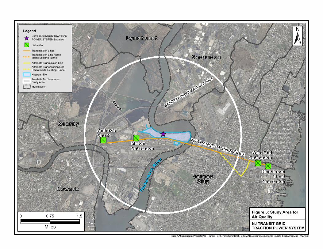
Figure 6. Study Area for Air Quality…………………………………………………………………..…..……………………….22
NJ TRANSITGRID Traction Power System
Page | 1
1.0 INTRODUCTION
The Federal Transit Administration (FTA) and New Jersey Transit Corporation (NJ TRANSIT) will
prepare an Environmental Impact Statement (EIS) in accordance with the National Environmental
Policy Act of 1969 (NEPA) and FTA’s regulations for implementing NEPA for the proposed NJ
TRANSITGRID TRACTION POWER SYSTEM (the proposed Project). The proposed Project is a first of a
kind microgrid designed to provide highly reliable power to support a core segment of NJ TRANSIT’s
critical transportation services and infrastructure needs. As defined by the U.S. Department of
Energy (DOE), a microgrid is a localized grouping of electricity sources and loads that normally
operate connected to and synchronous with the traditional centralized grid, but can disconnect and
function autonomously as physical and/or economic conditions dictate.
The proposed Project will include an approximate 104-megawatt (MW) natural gas fired electric
power generating plant (referred to as the Main Facility) and associated infrastructure to provide
traction power (i.e., electricity needed to electrify railroad tracks) to enable trains to operate during
widespread power failures on a portion of the NJ TRANSIT and Amtrak systems, including some
sections of the Amtrak Northeast Corridor (NEC) and NJ TRANSIT Morris & Essex line, and the
Hudson-Bergen Light Rail (HBLR) System. The proposed Project will also be designed to support non-
traction loads including the signal system on a portion of the NJ TRANSIT Main Line (so that diesel
trains can operate during power outages), electrical loads at NJ TRANSIT Hudson-Bergen Light Rail
Stations and at the NJ TRANSIT Hoboken Terminal, and other NJ TRANSIT signal power, tunnel
ventilation, pumping, and lighting loads.
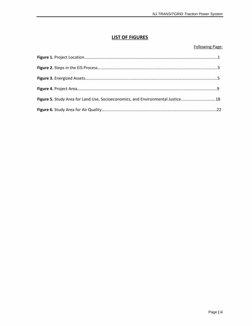
The proposed Project’s Main Facility will be located in Kearny, Hudson County, New Jersey (see
Figure 1).
NJ TRANSIT is also progressing a project called DISTRIBUTED GENERATION SOLUTIONS that will
provide power to certain train and bus stations and other transportation infrastructure in
northeastern New Jersey. Together the TRACTION POWER SYSTEM and the DISTRIBUTED
GENERATION SOLUTIONS are known as the NJ TRANSITGRID, which is a project that has been
selected by the FTA as eligible for funding as a public transportation resilience project in response to
Hurricane Sandy (Sandy) as part of a competitive selection process under the Emergency Relief
Program (79 FR 65762). The DISTRIBUTED GENERATION SOLUTIONS project can be constructed and
function independent from the TRACTION POWER SYSTEM project and serves an independent transit
purpose. Therefore, pursuant to NEPA, the TRACTION POWER SYSTEM project and the DISTRIBUTED
GENERATION SOLUTIONS project are being reviewed separately.
FTA and NJ TRANSIT have determined that the size of the proposed TRACTION POWER SYSTEM, the
potential for significant environmental impacts, and the level of public interest in the proposal
warrant the preparation of an EIS. The subject of this draft scoping document is the TRACTION
POWER SYSTEM Project.
_̂
Portal Portal BridgeBridge
Pulaski SkywayPulaski Skyway
New Je
rsey T
urnpik
e
New Je
rsey T
urnpik
e
Newark Bay Bridge
Newark Bay Bridge
Laurel Hill Laurel Hill ParkPark
AMTRAK NORTHEAST CORRIDOR
NJTRANSIT MORRIS & ESSEX
Legend
_̂ Project Location
NJTRANSIT Rail Kearny Peninsula Industrial/Intermodal Zone
Path: \\Atlas\gisdata\Projects\NJ_Transit\Tier3\TransitGrid\Draft_EIS\MXD\ScopingDocument\Figure1_Project_Location.mxd
0 1.5 3
Miles
Service Layer Credits: Content may not reflectNational Geographic's current map policy. Sources:National Geographic, Esri, DeLorme, HERE, UNEP-WCMC, USGS, NASA, ESA, METI, NRCAN, GEBCO,NOAA, increment P Corp.
NJ TRANSITGRID TRACTION POWERSYSTEM
Figure 1: ProjectLocation Map
±
Draft Scoping Document
Page | 2
This Draft Scoping Document provides details of Project scoping, the first step in the NEPA EIS
process. This document describes the proposed methodologies that will be used to assess the
proposed Project’s potential to cause significant social, economic, and environmental impacts.
Contained within this document is a discussion of the following topics:
Overview of the NEPA process;
Draft Purpose and Need;
Overview of Proposed Facility;
Alternatives to be Considered;
Draft Framework for Analysis of Potential Impacts; and
Draft Scope of Work for the Draft EIS.
FTA and NJ TRANSIT request comments on the scope of the Draft EIS, including the Purpose and
Need, Alternatives, and methodologies for analysis.
NJ TRANSITGRID Traction Power System
Page | 3
2.0 OVERVIEW OF THE NEPA PROCESS
NEPA (42 U.S.C. 4321 et. seq.) is a Federal law that serves as the Nation’s basic charter for
environmental protection. It requires that all Federal agencies, like FTA, consider the potential
environmental impacts of their proposed actions and disclose potential impacts to the public. NEPA
promotes better agency decision making by ensuring that high quality environmental information is
available to agency officials and the public before a federal agency decides whether and how to
undertake a proposed action. Through the NEPA process, the public and federal, state, and local
agencies have an opportunity to provide timely information and comments to FTA on the proposed
action1.
The EIS process consists of several steps (see Figure 2), each with opportunities for public and agency
involvement:
• Notice of Intent. FTA published a “Notice of Intent” to prepare an EIS in the Federal Register
on January 15, 2016, which advertised the availability of this Draft Scoping Document and
served as the starting point for the scoping process.
• Scoping Process. The scoping process provides federal, state, and local agencies and the
public with the opportunity to review and comment on the proposed methodologies that will
be used to assess the potential social, economic, and environmental impacts of the proposed
Project in the Draft EIS.
FTA and NJ TRANSIT request comments on the scope of the Draft EIS as described in this
document including the purpose and need, alternatives, and the methodologies presented to
assess potential social, economic, and environmental impacts. The scoping meeting will be
held on February 3, 2016 between 4 PM and 8 PM at the following location:
St. Peter’s University 2641 John F. Kennedy Blvd
Center Room Jersey City, NJ 07306
Comments received by February 29, 2016 will be reviewed by FTA and NJ TRANSIT and
incorporated, as appropriate, into a Final Scoping Document, which will initiate the
preparation of the Draft EIS.
• Draft EIS. FTA will consider the scoping comments in preparing a Draft EIS. The Draft EIS will
document environmental conditions in the Project area, and describe the potential for social,
economic and environmental impacts that may result from the proposed Project’s
construction and operation. Project benefits will also be presented. Measures to mitigate
significant adverse impacts, if any, will be identified.
1 An Agency and Public Coordination Plan has been prepared for the proposed Project and can be found at
http://njtransitresilienceprogram.com/documents.
Draft Scoping Document
Page | 4
• Public Comment on the Draft EIS. After FTA issues a Draft EIS, the U.S. Environmental
Protection Agency (EPA) will publish a “Notice of Availability” in the Federal Register to begin
the public comment period, which will last for 45 days. The “Notice of Availability” and other
advertisements will announce details on how to submit comments on the Draft EIS and when
a public hearing will be held to receive oral and written comments.
• Combined Final EIS/Record of Decision (ROD). Comments on the Draft EIS will be
considered in the Final EIS. FTA and NJ TRANSIT intend to issue a combined Final EIS and
ROD in accordance with Section 1319 of Map-21, which directs the lead agency, to the
maximum extent practicable, to expeditiously develop a single document unless certain
conditions exist, as listed below. The ROD announces and explains FTA’s decision and
describes any commitments for mitigating potential social, economic, and environmental
impacts. Section 1319(b) of Map-21 directs the lead agency (in this case FTA), to the
maximum extent practicable, to combine the Final EIS and ROD into a single document
unless:
o The Final EIS makes substantial changes to the proposed action that are relevant to
environmental or safety concerns; or
o There are significant new circumstances or information relevant to environmental
concerns and that potentially affect the proposed action or the impacts of the
proposed action.
After a 30 day period that follows the issuance of the combined Final EIS/ROD, advanced
project design can begin. Figure 2 depicts the process from Notice of Intent to ROD, and the
expected timeframe for these activities to be completed for the proposed Project.
NJ TRANSITGRID Traction Power System
Page | 5
3.0 DRAFT PURPOSE AND NEED
The purpose of the proposed Project is to enhance the resiliency of the electricity supply to the NJ
TRANSIT and Amtrak infrastructure that serves key commuter markets in New York and New Jersey
to minimize public transportation service disruptions. The region’s public transportation
infrastructure is vulnerable to power outages due to the nature of the existing centralized power
distribution system and the intensity and frequency of severe weather events.
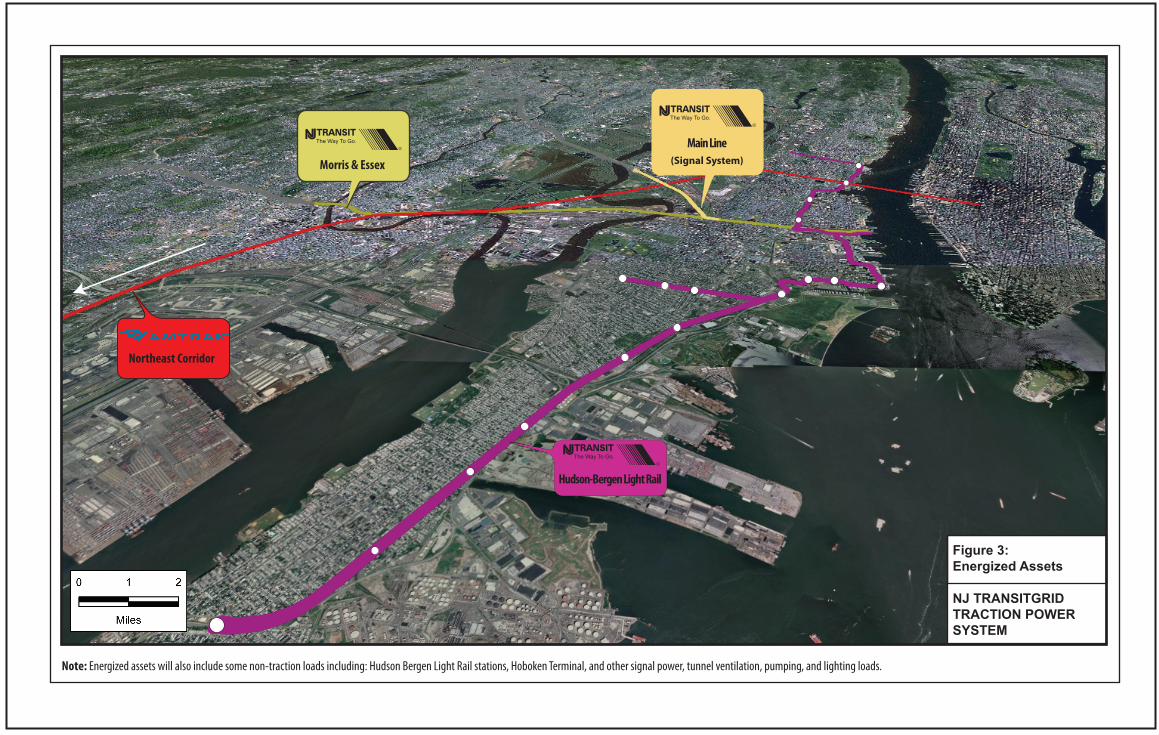
The proposed Project will provide an electric power generation system, called a microgrid, to provide
energy to operate a portion of the NJ TRANSIT and Amtrak rail systems, including some sections of
the Amtrak Northeast Corridor and NJ TRANSIT Morris & Essex line, and the NJ TRANSIT Hudson-
Bergen Light Rail System (see Figure 3). The proposed Project will also be designed to support non-
traction loads including the signal system on a portion of the NJ TRANSIT Main Line (so that diesel
trains can operate during power outages), signal systems at NJ TRANSIT Hudson-Bergen Light Rail
Stations and at the NJ TRANSIT Hoboken Terminal, and other NJ TRANSIT signal power, tunnel
ventilation, pumping, and lighting loads.
The need for the proposed Project and background information, are presented below. NJ TRANSIT’s
goals and objectives in developing and evaluating the project alternatives based on the purpose and
need for the proposed Project are also outlined below.
3.1 Background
Over the course of two years, New Jersey experienced three major weather events that had direct
impacts on the State’s existing commercial power grid. In August 2011, Hurricane Irene brought
devastating rains, winds, and flooding that resulted in more than 2.2 million people throughout the
State being left without power for up to eight days. Later that year in October, a large early
snowstorm knocked out power to more than a million people for up to seven days. Sandy caused
major damage in New Jersey and New York in the fall of 2012. The storm hit the area with maximum
sustained winds of 70 knots, and was accompanied by a storm surge into the coastal regions of both
states. It resulted in power outages to approximately 2.6 million utility customers over a period of 15
days (with some outages lasting much longer) and caused an estimated $50 billion in damage and an
even greater impact to the economy.
The public transportation infrastructure that connects Manhattan with northeastern New Jersey
across the Hudson River, which is critical from a security and economic standpoint, was severely
affected in each of these cases. The ensuing power outages affected a large percentage of this
region’s public transportation, operated by NJ TRANSIT, the Port Authority of New York and New
Jersey, and Amtrak, including NJ TRANSIT’s light rail and commuter rail, as well as ferry facilities in
the region. Public transportation service remained disrupted for a protracted period of time after
the storm.
The electric rail lines operating between New Jersey and New York City job centers are critical to the
region’s transportation network. Of 400,000 daily trans-Hudson New Jersey commuters traveling to
Hudson-Bergen Light Rail
Morris & Essex
Main Line(Signal System)
Northeast Corridor
Figure 3:Energized Assets
Note: Energized assets will also include some non-traction loads including: Hudson Bergen Light Rail stations, Hoboken Terminal, and other signal power, tunnel ventilation, pumping, and lighting loads.
NJ TRANSITGRID TRACTION POWER SYSTEM
Draft Scoping Document
Page | 6
jobs in New York City, approximately 36 percent or 143,000 depend on rail service. When Sandy
caused the loss of regional electric power, the system failed and travelers were stranded. Many tried
to use substitute buses and ferries, but encountered hours of delay. The Port Authority Bus Terminal
operates at capacity and could not absorb the additional travelers that are normally carried by rail.
The DOE has partnered with the State of New Jersey to examine the use of microgrids to help supply
electricity during future extreme weather events. This proposed Project is a result of that
partnership and it is designed to meet the objectives of national and State energy goals by
contributing to diverse portfolios of new, cleaner, and more resilient energy generation systems.
3.2 Need for the Proposed Project
The need for the proposed Project is based on the vulnerability of NJ TRANSIT’s rail service to power
outages, which are occurring more frequently due to the nature of the existing centralized power
distribution system and the intensity and frequency of severe weather events.
Severe Weather and the Existing Commercial Power Grid
America’s commercial electric grid is comprised of three smaller grids, called interconnections that
move electricity around the country. The Eastern Interconnection operates in states east of the
Rocky Mountains, the Western Interconnection covers states between the Pacific Ocean and the
Rocky Mountains, and the Texas Interconnection covers most of Texas. Severe weather is the
number one cause of power outages in the United States, costing the economy between $18 and $33
billion every year in lost output and wages, spoiled inventory, delayed production and damage to
grid infrastructure. Because the existing electric grid is so large and interconnected, it is vulnerable to
widespread disruption from severe weather and physical or cyber-attacks2. Microgrids are a leading
technology in the effort to develop a more resilient electrical grid via the production of cleaner
power in decentralized locations.
Currently, the existing commercial power grid relies heavily on mass burn power plants that are
generally located far from population centers due to their size and environmental impact. The
existing transmission and distribution grid distributes bulk power from the central power plants to
load centers (i.e., transmission to substations) and from load centers to consumers (i.e., distribution
via power lines). The existing network is inefficient, as significant energy losses occur in the
transmission and distribution of electricity over relatively long distances, between the power source
and receivers. The existing commercial power grid is particularly vulnerable to severe weather
resulting in but not limited to fallen trees and branches that can cause widespread power outages
due to the extent of the service territory, length of the transmission/distribution lines.
There is also increasing concern that man-made events could put the existing commercial power grid
at significant risk. Intentional attacks are a relatively new and emerging threat to power systems. A
comprehensive study conducted by a special committee of the National Research Council and funded
2 http://www.energy.gov/articles/keeping-power-flowing.
NJ TRANSITGRID Traction Power System
Page | 7
jointly by the National Academy of Science and the U.S. Department of Homeland Security entitled
“Terrorism and the Electric Power Delivery System” dated 2012, provides compelling evidence that
the cumulative threats to the electric power generating and transmission systems from physical and
cyber-attacks could cause region-wide power outages that last days if not longer. Although to date,
attacks on the U. S. system have been limited to small scale vandalism, from November 1, 1996 to
November 1, 2006, 528 substations and 2,539 transmission towers were attacked worldwide from
physical and cyber-attacks.
Frequency of Severe Weather Events Affecting NJ TRANSIT Service
As indicated above, Sandy was only the latest of several major events affecting rail transportation in
northern New Jersey. Hurricane Floyd in 1999, the Northeast Blackout in 20033, Hurricane Irene in
2011, the Halloween nor’easter on the heels of Hurricane Irene, and Tropical Storm Andrea in 2013
also caused major disruption. Smaller but more frequent storms also cause outages that disrupt
railroad operations. In the period between 2011 and 2013 alone, NJ TRANSIT recorded 49 power
outages affecting rail operations within the NJ TRANSITGRID TRACTION POWER SYSTEM service area
(excluding the outages caused by Hurricane Irene and Sandy), with a total duration of over 95 hours.
There is wide recognition that transportation resiliency in this critical area is a high priority.
Regional Mobility and Reliable Electric Power
Reliable electric power is essential to regional mobility as diesel trains are not permitted to operate
in the Hudson River rail tunnels due to diesel exhaust. Furthermore, electric power is necessary to
operate the signal system in the tunnels, to safely route train movements. Power is also necessary to
support critical emergency activities in preparation for and following flooding events, as maintenance
facilities, pump stations, and emergency operation centers need to be energized to pump water from
the tunnels and inspect equipment to return trains to revenue service. Despite the use of emergency
diesel generators, which offer some degree of resilience (although extended use raises significant
fuel availability and air quality concerns), the region’s rail transportation system was largely shut
down after Sandy, with enormous economic consequences. The loss of rail service in its entirety for
nearly a week challenged all prior expectations of the system’s resilience.
3.3 Project Goals
The following goals and objectives were developed by NJ TRANSIT to guide the development and
evaluation of the alternatives for NJ TRANSITGRID TRACTION POWER SYSTEM:
Project Goal No. 1: Provide a highly reliable parallel power source (to the existing commercial
power grid) to support the resilience of NJ TRANSIT’s and Amtrak’s public transportation services in
northeastern New Jersey and New York.
3 The Northeast Blackout of 2003 was not caused by a severe weather event. The blackout was due to
infrastructure failure from a computer glitch as well as power lines that were compromised by overgrown trees.
Draft Scoping Document
Page | 8
Utilize modern state-of-the-art resilient equipment;
Incorporate advanced resilient safety technology;
Minimize the length of transmission lines to increase reliability; and
Complement the projects in the NJ TRANSIT Resilience Program.
Project Goal No. 2: Achieve economic feasibility and cost-effectiveness.
Operate 24/7 and generate operating revenue;
Minimize capital costs; and
Minimize Operating and Maintenance (O&M) costs.
Project Goal No. 3: Expedite Project Delivery.
Minimize construction risk;
Minimize schedule risk; and
Maximize efficiencies in the environmental review/permitting processes.
Project Goal No. 4: Minimize impacts to the natural and built environment.
Minimize property acquisition requirements to the maximum extent feasible;
Reduce direct and indirect sources of air emissions to the maximum extent feasible;
Minimize the need to construct in wetlands and open waters;
Avoid impacts on parklands, open spaces and environmental conservation areas; and
Minimize construction impacts to the extent feasible.
NJ TRANSITGRID Traction Power System
Page | 9
4.0 PROJECT DESCRIPTION
The proposed Project will be a microgrid scaled to provide highly reliable power for NJ TRANSIT and
Amtrak operations operating between New York’s Penn Station and northeastern New Jersey (see
Section 4.3 below). A state-of-the-art natural gas-fired generation plant (Main Facility) was identified
as the most cost-effective choice to serve the traction power load identified. Clean-burning natural
gas will provide fuel for the combustion turbines and/or engines.
The Main Facility site was selected based on a site screening analysis that evaluated properties on
the Kearny Peninsula near two existing substations --NJ TRANSIT’s Mason and Amtrak’s Sub 41
substations (see Attachment A). These two substations will receive the highest electrical loads from
the Main Facility via transmission lines (see Figure 4). The site is part of a large tract of land owned
by the Hudson County Improvement Authority (HCIA), which lies within an area called Koppers Coke
Peninsula (aka Koppers Koke Peninsula), which is subject to the New Jersey Meadowlands
Commission (NJMC) Koppers Coke Peninsula Redevelopment Plan (February 2013). The NJMC
(recently renamed the Meadowlands Regional Commission, which resides within the New Jersey
Sports and Exposition Authority), is seeking to encourage brownfield redevelopment on this parcel.
HCIA is preparing the site for development, which includes elevating the site to meet flood elevation
criteria (to comply with New Jersey’s Uniform Construction Code and other relevant requirements4)
and construction of an access road around the site and to NJ Route 7 (Belleville Turnpike). The Main
Facility Siting Analysis is included in Attachment A.
4.1 On-Site Components
Main Facility
The Main Facility size and arrangement will depend on the selected power plant technology—gas
turbine and/or reciprocating engine, with or without hot exhaust powering a steam power plant (i.e.,
Heat Recovery Steam Generators, combined cycle) to increase power generation and thermal
efficiency. The Main Facility will consist of engine and/or turbine bays with a traveling crane; an
auxiliary bay for feed water heaters, pumps, and switchgear; and, a steam generator bay and general
spaces as may be required for a machine shop, locker room, laboratory, and office facilities.
Switchgear and motor controls for an auxiliary (black start) power system will be enclosed within
manufacturer supplied walk-in metal housings or site fabricated closures. Two stacks, for ventilation
of natural gas by products (e.g., carbon dioxide, methane, and nitrous oxide) will be located near the
center of the parcel.
In addition to the Main Facility, project-related substations, transformers, and frequency converters
will be built on the Main Facility site to accommodate the different power needs of Amtrak’s
Northeast Corridor and NJ TRANSIT’s commuter and light rail services. Electricity requirements differ
4 N.J.A.C. 5:23 and Bulletin 13-1B (DCA, September 2013), Special Adoption Elevation of an Existing Building
(DCA, October 2014), Flood Resistant Design and Construction (ASCE/SEI 24-14); Executive Order 13690 (Jan 15, 2015); and NJ TRANSIT Flood Elevation Design Criteria (May 2014).
"S
"S
"S
"S
_̂
Portal Bridge
Laurel Hill Park
Holy Name Cemetery & Mausoleum
PATH
Route 7
J e r s e yC i t y
K e a r n y
Port Jervis Line
Montclair Boonton Line
Northeast Corridor
Morris & Essex
MasonMasonSubstationSubstation
HendersonHendersonStreetStreetSubstationSubstation
Amtrak's Amtrak's Sub 41Sub 41
West EndWest EndSubstationSubstation
Path: \\Atlas\gisdata\Projects\NJ_Transit\Tier3\TransitGrid\Draft_EIS\MXD\ScopingDocument\Fig4_ProjectArea.mxd
±Legend
_̂ NJTRANSITGRID TRACTION POWER SYSTEM LOCATION
"S Existing SubstationsProposed Transmission LinesProposed Transmission Line Route Inside Existing TunnelProposed Alternate Tranmission LineProposed Alternate Transmission Line Route Inside Existing TunnelExisting TRANSCO Gas PipelinesProject AreaKoppers SiteMunicipality
0 0.5 1
MilesNJ TRANSITGRID TRACTION POWERSYSTEM
Figure 4: Project Area
HHaacc kk
ee nnssaa
cckk RRiivveerr
Draft Scoping Document
Page | 10
for different types of railroad facilities and the different rail lines. Alternating Current (AC) and Direct
Current (DC) voltage describe types of current flow in an electric circuit. The electric charge (current)
only flows in one direction in DC voltage, whereas it changes direction periodically (sine wave) with
AC voltage. The Northeast Corridor is a low frequency (25 Hertz) AC system, whereas NJ TRANSIT’s
Morris &Essex Line is a 60Hz AC system and the HBLR system is a 750V DC system. NJ TRANSIT’s train
stations, and other non-traction power loads, use 60Hz AC voltage. In a power plant, electricity is
generated at a convenient voltage for the design of the generator and then stepped up to a high
voltage for transmission. Near the loads, the transmission voltage is stepped down to the voltages
used by the equipment. Voltage is increased or decreased with the use of transformers. Substations
house equipment including frequency converters that are used to convert the transmission line
power into specified usable form.
Water, Sewer, and Other On-Site Facility Elements
The Main Facility site contains no sanitary sewers. Plans for sanitary service will be developed in
consultation with HCIA and other developers of the Redevelopment Area for connection to a gravity
sanitary sewer located in the right-of-way of NJ Route 7 (Belleville Turnpike) or one located at the
intersection of Jacobus and Pennsylvania avenues. Storm water flows will be discharged using an on-
site detention basin and other best management practices to maintain peak rates of discharge and
minimize the potential for erosion and sedimentation.
Infrastructure related to water use and waste water discharge will depend on technologies selected
for power generation. Other major on-site facility components will include tanks for ammonia and
service/fire water.
Natural Gas Pipeline Interconnection
The Build Alternative will utilize natural gas as a source of fuel for its combustion turbines and/or
reciprocating engines. Pipeline-quality natural gas will be delivered via a new interconnection with
one of the existing high pressure transmission lines that traverse a six-acre parcel in the
Redevelopment Area. This parcel contains three natural gas pipelines. Two are owned by PSE&G (16
and 20 inch diameter pipes) and the other (a 12 inch diameter pipe) is owned by The Williams
Company (formerly known as TRANSCO). From the Main Facility site, the new gas line will extend
eastward along the southern border of the Redevelopment Area, run beneath the Morris & Essex
line, and southward within the six acre parcel to connect to an existing pipeline. An interconnection
agreement with The Williams Company or PSE&G will be developed.
4.2 Off-Site Components
Supplying Power to the NJ TRANSIT Morris & Essex line
A double-circuit 230 kilovolt (kV) transmission line between the Main Facility site and the existing NJ
TRANSIT Mason Substation will be installed running along the NJ TRANSIT right-of-way. The existing
transmission towers will be evaluated for structural soundness to determine whether they can
support the new transmission lines. New transmission towers may have to be installed depending on
NJ TRANSITGRID Traction Power System
Page | 11
the results of the structural survey. The NJ TRANSIT Mason Substation will be expanded to
accommodate two new 230 kV feeders. The Main Facility site will be coincident with the M&E Line
and no property acquisition is anticipated to be required for these improvements.
Supplying Power to NJ TRANSIT’s HBLR, HBLR Stations, and the Hoboken Terminal
One or two new 13 kV feeders from Henderson substation will be installed along the NJ TRANSIT
HBLR right-of-way to provide a microgrid connection for the existing traction facilities. Because NJ
TRANSIT’s HBLR passenger stations are adjacent to the light rail lines, it will be possible to supply
power to the passenger stations directly from the traction feeders using a small single-phase
transformer. NJ TRANSIT’s West End and Henderson 13 kV substations will be reconfigured to
accommodate an additional feeder from the Main Facility site. Between the Main Facility and
Henderson substation two transmission line routes, both partially in existing NJ TRANSIT-owned
tunnels, will be considered (see Figure 4).
Supplying Power to Amtrak’s Northeast Corridor
A new substation near Amtrak’s Sub 41 substation will be constructed to accommodate the
microgrid connections. Property either to the east or west of Sub-41 adjacent to the Northeast
Corridor will be acquired for this improvement. Two new 138 kV Hz single-phase overhead circuits
along NJ TRANSIT’s right-of-way, connecting the transformers and frequency converters at the Main
Facility site to the new substation will be installed. The existing transmission towers, including those
in open water between Amtrak’s Sub 41 substation and NJ TRANSIT’s Morris & Essex Line, will be
evaluated for structural soundness to determine whether they can support the new transmission
lines. New transmission towers may have to be installed depending on the results of the structural
survey and the final alignment of the transmission lines to the new Sub 41.
4.3 Facility Operations
The microgrid will be electrically connected to PSE&G and the Pennsylvania New Jersey Maryland
Interconnection LLC (PJM). PSE&G is New Jersey’s largest provider of electric and gas service and
currently provides power to NJ TRANSIT and Amtrak facilities in the Project area, including the
traction power substations. PJM is a regional transmission organization that coordinates the
movement of wholesale electricity and manages the high-voltage electricity grid to ensure reliability.
PJM exercises “operational authority” over the PSE&G transmission facilities.
Emergency Operating Conditions
Under a scenario involving a regional or local blackout condition, the microgrid will become the
primary source of power for the affected NJ TRANSIT and Amtrak facilities in the Project Area (see
Figure 4). It will provide traction power to support the following services (see Figure 3):
Limited commuter rail service on Amtrak’s Northeast Corridor between New York Penn
Station and County Yard/Jersey Avenue Station in New Brunswick via connection to Amtrak’s
Sub 41 substation;
Draft Scoping Document
Page | 12
Limited NJ TRANSIT commuter rail service between Hoboken and Newark’s Broad Street
Station on the Morris & Essex Line, via connection to the NJ TRANSIT Mason Substation; and,
Service on NJ TRANSIT’s HBLR between Tonnelle Avenue and 8th Street in Bayonne, via
connection to the NJ TRANSIT West End and Henderson Substations.
In addition to providing traction power, the microgrid will be designed to support the following non-
traction loads:
NJ TRANSIT Hoboken Station through input to Henderson Substation;
NJ TRANSIT HBLR Stations supported through modifications of feeds at the Henderson
Substation;
Additional NJ TRANSIT signal power, tunnel ventilation, pumping, and lighting loads; and,
Amtrak signal power, tunnel ventilation, pumping, and lighting loads.
The service territory was chosen to support an overall service goal of transporting as many customers
as possible between key nodes in NJ TRANSIT’s core public transit system. Newark, Hudson County,
the Hudson River waterfront area in New Jersey, and the Central Business District in Manhattan
represent the areas with very high transit dependency for work and non-work trips. Connections
between NJ TRANSIT’s highest volume rail stations (Newark Penn Station, Newark Broad Street,
Hoboken Terminal and Secaucus Junction) and Penn Station New York are critical to maximizing the
number of passengers transported. During power outages, NJ TRANSIT’s intrastate bus services will
be redirected to locations where travelers can transfer to available trans-Hudson rail services. There
are four primary locations where trans-Hudson travelers will be able to board public transit into
Manhattan: Hoboken Terminal, Secaucus Junction, Weehawken Ferry Terminal and Newark Penn
Station. There are also a few smaller locations where travelers will be able to access lower-capacity
private ferry services. To maximize capacity, shuttle trains will operate between Newark Penn Station
and Penn Station New York, and between Secaucus Junction and Penn Station New York.
The size of the Main Facility will be based on historical electrical demand data and by considering the
unique aspects of traction power for rail service, since it represents the vast majority of the peak
load requirement. Based on conceptual estimates, a generation capacity of approximately 104 MW
will accommodate the estimated peak hourly loads and account for intra-hour variability, to ensure
adequate ramping capability and operational flexibility. Preliminary estimates assume that
approximately 60 MW, 14 MW, and 6 MW will be supplied to the Northeast Corridor, Morris & Essex
Line, and HBLR respectively5. NJ TRANSIT will perform additional analyses and the size of the facility
may increase or decrease based on a review of more detailed energy usage data.
Normal Operating Conditions
Under normal conditions, when the existing commercial power grid is fully available, the microgrid
will be capable of operating in parallel with it, to meet demand in the most reliable and cost-effective
5 NJ TRANSITGRID Feasibility Study, February 2014. Sandia National Laboratories.

NJ TRANSITGRID Traction Power System
Page | 13
manner. The system will be capable of accruing added value in terms of higher reliability and
competitive electricity cost to enable participation in the energy market place. The microgrid will
operate under normal operating conditions in order to generate revenue for NJ TRANSIT to be placed
back into transit purposes and meet the proposed Project’s goal of achieving economic feasibility and
cost effectiveness.
Draft Scoping Document
Page | 14
5.0 ALTERNATIVES
The Draft EIS will evaluate a No Action Alternative and Build Alternative, with design options. A
natural gas-fired generation plant was found to be the most cost-effective choice for the Main
Facility given the magnitude (approximately 104 MW) of the power loads for railroad operations that
will be needed under emergency conditions.
Two engine technologies and two types of power plants will be evaluated as design options for the
Main Facility, as follows:
Reciprocating Engine Options
o A simple-cycle reciprocating engine plant, with multiple reciprocating engines;
o A combined-cycle reciprocating engine plant, configured with multiple
reciprocating engines and one steam turbine;
Gas Turbine Options
o A simple-cycle combustion-turbine plant, with three combustion turbines; and
o A combined-cycle gas turbine plant (CCGT), configured with two combustion
turbines and one steam turbine.
The Build Alternative could include one of the four options listed above or a combination of
reciprocating engine and gas turbine technologies, depending on the results of an alternatives
analysis, which will evaluate the options in relation to the proposed Project’s goals and objectives.
5.1 Reciprocating Engine Options, Simple- or Combined-Cycle
Reciprocating engines are well-known technology; as they are used in automobiles, trucks, marine
propulsion, and backup power applications. Emissions from natural gas-fired units are low, allowing
the plant to meet stringent emission rules, and allowing the units to take advantage of local natural
gas transmission supply without the need for storage. The engines can be stopped and started
multiple times per day throughout the year without resulting in excessive wear and tear. They can
cycle up and down without impact on O&M cost. Minimal water would be needed for this plant
type. Although available in smaller sizes for standby applications, reciprocating engines for large-
scale power generation range in size from 4 MW to 20 MW, which are grouped into a block of
engines. These plants are highly efficient, with simple-cycle efficiencies of 46 to 49 percent. The
smaller scale units can be operated in parallel and deployed as needed to meet a rapidly fluctuating
load. This plant type also lends itself well to modularity in both architecture and operation, reducing
construction costs and allowing operational flexibility.
While individual engines do operate less efficiently as their output decreases from full load, the
number of engines in a plant allows one to meet load by varying the number of engines on or off. By
cascading engines, plant efficiency can be maintained at close to full load efficiency across the load
spectrum. The reliability of a multiple-shaft reciprocating engine plant is likely to be higher than for a
three-shaft (each of the two combustion turbines plus the steam turbine) CCGT plant.
NJ TRANSITGRID Traction Power System
Page | 15
The reciprocating engine plant could be configured as a combined-cycle plant with the addition of a
heat recovery steam turbine, and this option will be examined from a cost-benefit standpoint.
Generally, heat recovery increases the efficiency of the plant, but also requires significantly more
capital outlay. Maximum plant efficiency operating in combined-cycle mode would be approximately
49%. Nominal quantities of water would be needed to supply makeup water for the primary steam
loop. As with any steam turbine, the condenser can be cooled with air-cooled radiators or with
water. If water is used, then there are two possibilities: once-through cooling or cooling towers.
Plant-siting is less constrained with air-cooled radiators since water and its discharge would not be
needed. Using water for cooling improves efficiency, but introduces water use, and likely increases
capital costs.
5.2 Gas Turbine Options, Simple- or Combined-Cycle
The Gas Turbine Single-Cycle option would have a maximum efficiency of roughly 40 to 42 percent.
Excessive combustion turbine starting and stopping may cause wear and tear on the units, increasing
maintenance frequency and cost. The whole plant would obtain that maximum efficiency with one,
two, or three units at full load. Any time a combustion turbine is operated at partial load, unit
efficiency declines significantly. When operating at minimum load, the combustion turbine would
likely be at about 30% efficiency.
Combined-cycle plants, using combustion turbines and heat-recovery steam generators that deliver
steam to turbines, will be evaluated. In combined cycle, the plant can be up to 54 percent efficient. If
implemented, nominal amounts of water would be needed for makeup water for the steam loop.
Use of air-cooled radiators will be explored. Using water for cooling improves efficiency, but
introduces water use and consumption requirements, and would likely increase capital costs.
5.3 Other Technologies
The use of solar photovoltaic (PV) panels, wind energy, and other “green” technologies to fully
“island” the NJ TRANSIT and Amtrak electrical systems from the larger commercial power grid are not
practical or reasonable alternatives to a natural gas-fired generation plant due to siting requirements
for these technologies, the need to meet rapidly fluctuating loads associated with traction power
systems, and costs, especially due to the need for energy storage to guarantee a reliable power
source. Therefore, these options will not be evaluated in the DEIS.
Draft Scoping Document
Page | 16
6.0 ANALYSIS FRAMEWORK
6.1 Affected Environment and Analysis Year
The Draft EIS will describe Existing Conditions for each environmental topic area for the year
2015/2016. No Action Conditions will also be described by identifying projects with a reasonable
likelihood of being completed by 2021, which is the proposed Project’s build completion year.
Collectively, Existing and No Action conditions will be termed “Affected Environment” in the Draft
EIS.
6.2 Potential Impacts of the Proposed Project
The future Build Alternative will be evaluated against the future No Action Alternative to identify the
potential impacts of the Build Alternative on the Affected Environment. The potential impacts of
the proposed Project will be evaluated under normal operating conditions. If the conditions under
normal and emergency operating conditions are different, then potential impacts under both
conditions will be evaluated.
6.3 Impact Mitigation
The Draft EIS will identify reasonable and practicable mitigation measures to reduce or eliminate
significant adverse environmental impacts that would be caused by the proposed Project, as
required.
6.4 Study Areas
The environmental impact analyses will define study areas for each specific environmental topic
area that are sufficient in size to identify primary and secondary effects. A study area for the Main
Facility site and study areas for other elements located outside the Main Facility site will be defined.
Accordingly, study areas are delineated in the descriptions of individual technical analyses in Section
7.0 below. Analysis methods for assessing impacts are also discussed in the individual technical
analysis section.
NJ TRANSITGRID Traction Power System
Page | 17
7.0 SCOPE OF WORK FOR THE DRAFT EIS
The Draft EIS will be prepared to comply with NEPA, FTA’s Environmental Impact and Related
Procedures (23 CFR Part 771), Council on Environmental Quality (CEQ) regulations implementing
NEPA (40 CFR 1500), as well as Section 106 of the National Historic Preservation Act of 1966 (NHPA),
Section 4(f) of the U.S. Department of Transportation Act (1966), Executive Order 12898, “Federal
Actions to Address Environmental Justice in Minority Populations and Low-Income Populations,” and
other relevant regulations. Under NEPA, FTA is the lead Federal agency for the Project and NJ
TRANSIT is the Project sponsor.
There are no wild and scenic rivers or farmland in the Project area (see Figure 4). As a result, these
environmental topic areas will not be included in the Draft EIS. Long-term effects of the Build
Alternative could include impacts to ambient air quality levels, water resources, natural resources
and cultural resources depending on the type of facility constructed and its design. Measures to
mitigate the potential for adverse impacts will be identified in the Draft EIS and incorporated into
the design of the Build Alternative, as appropriate. Significant adverse impacts are not expected to
result in the environmental topic areas of: land use, zoning, public policy, socioeconomics, visual
quality/aesthetic resources, traffic and transportation, noise and vibration, indirect and cumulative
impacts, safety and security, and construction effects.
The methodologies that will be used to evaluate the potential for the No Action and Build
Alternative to affect social, economic, and environmental conditions in the study area are provided
below. A description of how the Build Alternative will be constructed and the potential for
construction-related impacts in each of the environmental topic areas will be presented in the
Construction Chapter in the DEIS.
Draft Scoping Document
Page | 18
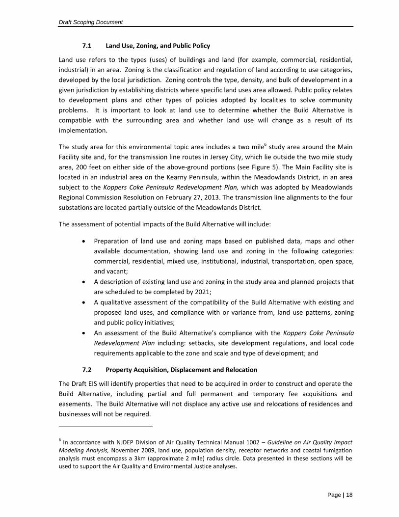
7.1 Land Use, Zoning, and Public Policy
Land use refers to the types (uses) of buildings and land (for example, commercial, residential,
industrial) in an area. Zoning is the classification and regulation of land according to use categories,
developed by the local jurisdiction. Zoning controls the type, density, and bulk of development in a
given jurisdiction by establishing districts where specific land uses area allowed. Public policy relates
to development plans and other types of policies adopted by localities to solve community
problems. It is important to look at land use to determine whether the Build Alternative is
compatible with the surrounding area and whether land use will change as a result of its
implementation.
The study area for this environmental topic area includes a two mile6 study area around the Main
Facility site and, for the transmission line routes in Jersey City, which lie outside the two mile study
area, 200 feet on either side of the above-ground portions (see Figure 5). The Main Facility site is
located in an industrial area on the Kearny Peninsula, within the Meadowlands District, in an area
subject to the Koppers Coke Peninsula Redevelopment Plan, which was adopted by Meadowlands
Regional Commission Resolution on February 27, 2013. The transmission line alignments to the four
substations are located partially outside of the Meadowlands District.
The assessment of potential impacts of the Build Alternative will include:
Preparation of land use and zoning maps based on published data, maps and other
available documentation, showing land use and zoning in the following categories:
commercial, residential, mixed use, institutional, industrial, transportation, open space,
and vacant;
A description of existing land use and zoning in the study area and planned projects that
are scheduled to be completed by 2021;
A qualitative assessment of the compatibility of the Build Alternative with existing and
proposed land uses, and compliance with or variance from, land use patterns, zoning
and public policy initiatives;
An assessment of the Build Alternative’s compliance with the Koppers Coke Peninsula
Redevelopment Plan including: setbacks, site development regulations, and local code
requirements applicable to the zone and scale and type of development; and
7.2 Property Acquisition, Displacement and Relocation
The Draft EIS will identify properties that need to be acquired in order to construct and operate the
Build Alternative, including partial and full permanent and temporary fee acquisitions and
easements. The Build Alternative will not displace any active use and relocations of residences and
businesses will not be required.
6 In accordance with NJDEP Division of Air Quality Technical Manual 1002 – Guideline on Air Quality Impact
Modeling Analysis, November 2009, land use, population density, receptor networks and coastal fumigation analysis must encompass a 3km (approximate 2 mile) radius circle. Data presented in these sections will be used to support the Air Quality and Environmental Justice analyses.
"S
"S
"S
"S
_̂
Route 7
NJ TRANSIT Morris & Essex
AMTRAK Northeast Corridor
L y n d h u r s t
N e w a r k
J e r s e yC i t y
K e a r n y
S e c a u c u s
MasonMasonSubstationSubstation
HendersonHendersonStreetStreet
SubstationSubstation
Amtrak's Amtrak's Sub 41Sub 41 West EndWest End
SubstationSubstation
Legend_̂
NJTRANSITGRID TRACTION POWER SYSTEM Location
"S Existing SubstationProposed Transmission LinesProposed Transmission Line Route Inside Existing TunnelProposed Alternate Tranmission LineProposed Alternate Transmission Line Route Inside Existing Tunnel200-ft Study Area for Land Use,Socioeconomics, and Environmental JusticeKoppers SiteTwo Mile Air Resources Study AreaMunicipality
HHaa cc kkee nn
ss aacc kk
RR iivvee rr
±
NJ TRANSIT GRIDTRACTION POWER SYSTEM
Figure 5: Study Area for Land Use, Socioeconomics and Environmental Justice0 0.75 1.5
MilesPath: \\Atlas\gisdata\Projects\NJ_Transit\Tier3\TransitGrid\Draft_EIS\MXD\ScopingDocument\Figure5_StudyAreaMap_LU_SE_EJ.mxd
NJ TRANSITGRID Traction Power System
Page | 19
7.3 Socioeconomic Conditions
In environmental planning, the environmental topic area called socioeconomic conditions includes
an assessment of social and economic conditions that could be affected by the Build Alternative.
This chapter will examine relevant socioeconomic conditions utilizing the same study areas
described above for land use (see Figure 5). The Build Alternative will not increase commuter rail
service, and will not result in the direct or indirect displacement of businesses or residences in the
study area. A small number of permanent jobs will be created to operate the facility, which would
not be expected to meaningfully affect employment statistics in the study area.
The assessment of potential impacts of the Build Alternative will include:
Identification of community facilities where elderly, young or the infirm congregate (i.e.,
the populations particularly sensitive to changes in air quality) including hospitals,
nursing homes, day-care centers, schools and public land (parks and recreational areas).
Since the proposed Project does not include residential development or new transit
service that could induce additional development, the Build Alternative would not be
expected to have an impact on community services.;
Presentation of 2010 U.S. Census data for each census tract in the study area and
comparison to relevant County and State data, for the following:
o Population density and population density trends to identify heavily populated
areas that, depending on the results of the air monitoring data, could be
adversely affected by the Project. Population projections from the North Jersey
Transportation Authority, the region’s Metropolitan Planning Organization, will
also be presented to project future population trends;
o Race/ethnicity, median household income, poverty, elderly and disability status.
An assessment of the potential for the Build Alternative to affect neighborhood
cohesiveness and community health and safety. General impacts (if any) to
disadvantaged groups (minorities and low-income individuals and families) will be
presented.
A description of the extent to which the Build Alternative will influence the local police
and fire departments and emergency medical service response to an event at the
facility.
An estimate of the number of permanent jobs and temporary construction jobs will be
provided.
Draft Scoping Document
Page | 20
7.4 Visual Quality/Aesthetic Resources
Aesthetic resources are physical features that make up the visible landscape, including land, water,
vegetation, and man-made elements to which viewers attach visual value. Aesthetic resources may
include historic buildings, open spaces and parks, and views to natural resources such as water
features and natural vegetation. This chapter will consider the effects of the Build Alternative on
aesthetic resources and visual quality in the study area. The assessment of potential impacts to
aesthetic resources and visual quality will take into account the sensitivity of viewer groups to the
proposed change in the visual landscape, and the duration and type of view that will be
experienced.
The study area for this environmental topic area will be defined based on the results of view shed
mapping, which will identify the areas of potential visibility of the above-ground elements of the
Build Alternative based on topography and the top of the structures with the highest peak
elevations (the stacks and transmission lines/poles).
The assessment of potential impacts of the Build Alternative will include:
A description of visual quality and aesthetic resources in the study area;
A description of the Build Alternative and photo simulations for representative views of
its above-ground elements;
Identification of sensitive viewing areas and locations of viewer groups in the study area
with access to views of the above-ground elements of the Build Alternative, including
visible plumes from the stack, lighting, and transmission line poles. Viewpoints will be
selected if there is unobstructed or direct line-of-sight views from significant viewpoints;
Description of the level of viewer exposure including the frequency of views or relative
number of people with that view;
Assessment of the nature and degree of visual change and characterization of potential
impacts to aesthetic resources in the study area.
The assessment will follow guidance found in the U.S. Department of Transportation Guidelines for
the Visual Impact Assessment of Highway Projects, January 2015, which represents current best
practices for conducting a thorough evaluation of visual impacts caused by a transportation project.
Since the facility is located in an area of industrial uses, and the facility’s structures and stacks are
not expected to exceed 50 feet in height, significant impacts to visual quality and aesthetic resources
are not expected to result from the new facility. The transmission lines will primarily be routed in
areas where there are already above ground transmission lines.
NJ TRANSITGRID Traction Power System
Page | 21
7.5 Traffic and Public Transportation
The Draft EIS will include analysis of the potential traffic and public transportation impacts related to
operation of the Build Alternative. The study area for this analysis will span the areas potentially
affected by the Build Alternative, as described below.
Traffic
Since relatively few employees (approximately 10 per shift) will be travelling to and from the Main
Facility site and deliveries to the facility will be minimal (on the order of a few per day), detailed
traffic analyses as per the Highway Capacity Manual procedures will not be performed. The existing
and planned roadway network will be described and Average Daily Traffic (ADT) will be obtained
from New Jersey Department of Transportation for the following roadways:
NJ Route 7 (Belleville Turnpike and Newark Turnpike Sections);
Newark Turnpike at Interstate Route 280 and US Route 1&9; and
Fish House Road.
The infrastructure improvements that are expected to be in place in the No Action condition will be
described. These include:
Koppers Coke Peninsula Redevelopment Area access roadway to NJ Route 7;
Wittpenn Bridge Replacement;
NJ Route 7 improvements; and
NJ Route 7-Fish House Road interchange realignment.
A comparison of projected future traffic conditions with and without the Build Alternative will be
provided.
Public Transportation
During normal operating conditions, there will be no noticeable impact on public transportation.
But during emergency operations, the microgrid will go into ‘”islanded” mode in order to provide
electric power to the following public transportation services potentially affected by power failure:
Amtrak’s Northeast Corridor between New York Penn Station and County Yard/Jersey
Avenue Station in New Brunswick;
NJ TRANSIT commuter rail service between Hoboken and Newark’s Broad Street Station
on the Morris & Essex Line; and
NJ TRANSIT’s HBLR between Tonnelle Avenue and 8th Street in Bayonne.
During power outages, the Build Alternative will directly benefit commuters in the region, to NJ
TRANSIT and Amtrak riders, who would otherwise have to rely on other slower and more congested
modes of transportation. Future No Action projects that will affect public transportation in the
study area will be described. A description of the potential impacts during power outages under the
No Action Alternative and Build Alternative will be provided.
Draft Scoping Document
Page | 22
7.6 Air Quality
Polluted air can cause or worsen lung-related diseases, such as emphysema, chronic bronchitis and
asthma; and can cause breathing difficulty. Polluted air can contribute to water pollution and lead
to decreased visibility and damaged trees, agricultural crops and other living organisms. In 1970,
Congress created the U.S. Environmental Protection Agency (EPA) and passed the Clean Air Act,
giving the federal government the authority to clean up air pollution in the U.S. Air pollutants
identified by EPA as being of concern nationwide are known as “criteria pollutants,” and include:
carbon monoxide (CO), nitrogen dioxide (NO2), ozone, particulate matter (PM10 and PM2.5), sulfur
dioxide (SO2), and lead (Pb).
In order to protect human health and welfare, National Ambient Air Quality Standards (NAAQS) and
New Jersey Ambient Air Quality Standards (NJAAQS) pollutant concentration standards (or limits)
have been established for each of the “criteria pollutants”. EPA has also identified a list of 187
Hazardous Air Pollutants (HAPs), which are known or suspected to cause cancer or other serious
health or environmental effects.
The Build Alternative will require permits under the EPA’s Title V program to ensure compliance
with the Clean Air Act. The permits are legally-enforceable documents that specify pollution control
measures and mandate compliance with federal and State air emissions requirements.
The study area for the air quality analysis includes a two-mile area around the Main Facility site
(see Figure 6). The assessment of potential impacts of the Build Alternative will include:
Presentation of existing climate data, air quality levels and air quality trends for criteria
pollutants in the region based on monitored data and existing reports;
An evaluation of optimal stack heights, pollution control technology, and stack emissions
criteria to meet Title V permit requirements;
An assessment of the potential impacts to ambient air quality for the criteria pollutants
based on a dispersion model developed in consultation with NJDEP and EPA and comparison
to the NAAQS/NJAAQS. Conservative assumptions will be used to capture reasonable worst-
case emissions and the effects of operations under both normal and emergency operating
conditions;
An assessment of Build Alternative’s ability to comply with Title V permit requirements;
A review of pertinent available data on non-criteria pollutants that could be emitted by
natural gas-fired combustion plants;
An assessment of the emission rates for non-criteria pollutants and comparison to the
applicable EPA criteria to determine the potential for adverse impacts to result from
operation of the Build Alternative.
"S
"S
"S
"S
_̂
Route 7
NJ TRANSIT Morris & Essex
AMTRAK Northeast Corridor
L y n d h u r s t
N e w a r k
J e r s e yC i t y
K e a r n y
S e c a u c u s
MasonMasonSubstationSubstation
HendersonHendersonStreetStreet
SubstationSubstation
Amtrak'sAmtrak'sSub 41Sub 41
West EndWest EndSubstationSubstation
Legend
_̂NJTRANSITGRID TRACTION POWER SYSTEM Location
"S SubstationTransmission LinesTransmission Line RouteInside Existing TunnelAlternate Tranmission LineAlternate Transmission Line Route Inside Existing TunnelKoppers SiteTwo Mile Air Resources Study AreaMunicipality
HHaa cc kkee nn
ss aacc kk
RR iivvee rr
±
NJ TRANSIT GRIDTRACTION POWER SYSTEM
Figure 6: Study Area for Air Quality0 0.75 1.5
MilesPath: \\Atlas\gisdata\Projects\NJ_Transit\Tier3\TransitGrid\Draft_EIS\MXD\ScopingDocument\Figure6_StudyAreaMap_AQ.mxd
NJ TRANSITGRID Traction Power System
Page | 23
7.6 Air Quality (Continued)
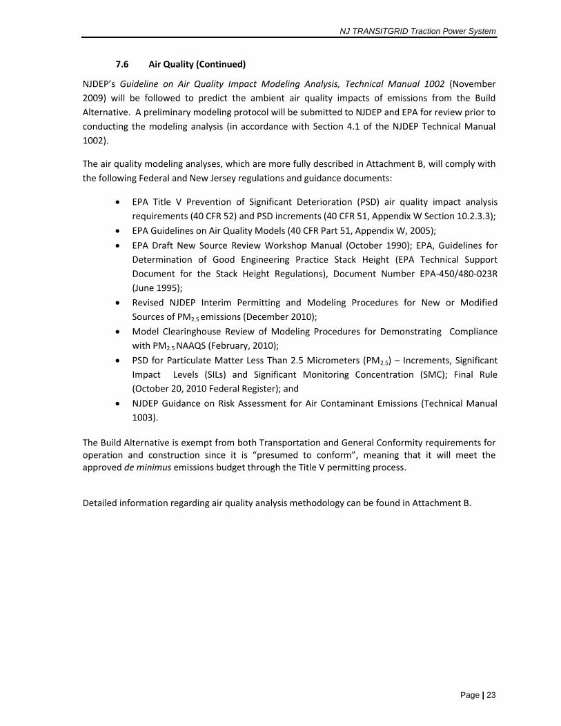
NJDEP’s Guideline on Air Quality Impact Modeling Analysis, Technical Manual 1002 (November
2009) will be followed to predict the ambient air quality impacts of emissions from the Build
Alternative. A preliminary modeling protocol will be submitted to NJDEP and EPA for review prior to
conducting the modeling analysis (in accordance with Section 4.1 of the NJDEP Technical Manual
1002).
The air quality modeling analyses, which are more fully described in Attachment B, will comply with
the following Federal and New Jersey regulations and guidance documents:
EPA Title V Prevention of Significant Deterioration (PSD) air quality impact analysis
requirements (40 CFR 52) and PSD increments (40 CFR 51, Appendix W Section 10.2.3.3);
EPA Guidelines on Air Quality Models (40 CFR Part 51, Appendix W, 2005);
EPA Draft New Source Review Workshop Manual (October 1990); EPA, Guidelines for
Determination of Good Engineering Practice Stack Height (EPA Technical Support
Document for the Stack Height Regulations), Document Number EPA-450/480-023R
(June 1995);
Revised NJDEP Interim Permitting and Modeling Procedures for New or Modified
Sources of PM2.5 emissions (December 2010);
Model Clearinghouse Review of Modeling Procedures for Demonstrating Compliance
with PM2.5 NAAQS (February, 2010);
PSD for Particulate Matter Less Than 2.5 Micrometers (PM2.5) – Increments, Significant
Impact Levels (SILs) and Significant Monitoring Concentration (SMC); Final Rule
(October 20, 2010 Federal Register); and
NJDEP Guidance on Risk Assessment for Air Contaminant Emissions (Technical Manual
1003).
The Build Alternative is exempt from both Transportation and General Conformity requirements for operation and construction since it is “presumed to conform”, meaning that it will meet the approved de minimus emissions budget through the Title V permitting process.
Detailed information regarding air quality analysis methodology can be found in Attachment B.
Draft Scoping Document
Page | 24
7.7 Greenhouse Gas Emissions
Following the approach and methodology provided in the Revised Draft Guidance on the
Consideration of Greenhouse Gas Emissions and the Effects of Climate Change in NEPA Reviews
(Council on Environmental Quality (CEQ), December 18, 2014), the potential GHG emissions
generated by the Build Alternative will be described in the Draft EIS.
When considering the potential effects of the Build Alternative, carbon dioxide (CO2), methane
(CH4), and nitrous oxide (N2O) are the primary GHGs of concern. In accordance with the draft CEQ
guidance, emissions of these pollutants will be considered and expressed in terms of carbon dioxide
equivalents (CO2e). The draft CEQ guidance identifies 25,000 metric tons of CO2e emitted annually
as a reference point below which a detailed quantified analysis for disclosure of a project’s
emissions is not warranted. As operation of the new facility will exceed this threshold, GHG
emissions will be quantified by taking into account annual operational emissions. The analysis will
include:
Direct emissions from the on-site combustion equipment, particularly the 104 MW power
generation facility. Calculations will be based on fuel consumption information from a
review of relevant equipment specifications. Fuel consumption estimates will be converted
to equivalent GHG emissions using the U.S. Energy Information Administration’s (EIA)
standard emission factors (Voluntary Reporting of Greenhouse Gases Program Fuel Carbon
Dioxide Emission Coefficients);
Indirect emissions from on-road vehicles associated with employee commutes and
deliveries. The total amount of emissions from vehicles trips generated by the facility will
be calculated using average commute distances from the U.S. Census Bureau for the NY-NJ
Metro Area for employee trips and making reasonable assumptions concerning delivery
trips. Emission rates for all on-road vehicles will be calculated using EPA’s MOVES2014
emission factor algorithm with appropriate area specific parameters provided by NJDEP.
For comparison purposes, the estimated annual emissions that would result from using
power from the existing commercial power grid for normal operations will be presented.
The reduction in GHG emissions that will result under the Build Alternative, due to the use
of cleaner burning natural gas in place of coal and oil-fired energy, will be estimated (see
Attachment B for more detail on the methodology that will be used for this assessment).
NJ TRANSITGRID Traction Power System
Page | 25
7.8 Noise and Vibration
The new facility will be designed to comply with all relevant noise and vibration codes. Equipment
will be enclosed and fan silencers, compressor silencers, mufflers on internal combustion engines,
acoustical material, vibration dampening and other measures will be incorporated into the design,
as required.
FTA has developed guidance for preparing and reviewing the noise and vibration sections of
environmental documents. This manual, called Transit Noise and Vibration Impact Assessment, May
2006, sets forth the methods and procedures for determining the level of noise and vibration impact
resulting from most Federally-funded transit projects and does not address noise and vibration from
power generation facilities. It is acknowledged in the manual that since its methods have been
developed to assess typical transit projects, there will be some situations not explicitly covered and
the exercise of professional judgment is required to extend the basic methods in these cases.
FTA’s guidance manual specifies different types of land use that is sensitive to noise and vibration
impacts and presents noise and vibration screening procedures that are designed to identify
locations where a project may cause noise or vibration impacts. If no noise/vibration-sensitive land
uses are present within a defined area of project noise influence, then no further noise or vibration
assessment is necessary. The screening procedures take into account noise and vibration impact
criteria, the type of noise/vibration generating project, and the proximity of noise/vibration-
sensitive land uses.
Since the nearest sensitive land uses as per FTA guidance are located approximately 0.7 and 0.8
miles away (residential property and parkland, respectively) from the proposed Main Facility site,
facility noise and vibration are not expected to be noticeable at these receptors. Therefore, the
potential for noise and vibration impacts will be qualitatively addressed in relation to FTA’s
screening procedures in the Draft EIS.
Draft Scoping Document
Page | 26
7.9 Cultural Resources
The Build Alternative will be evaluated for potential effects on historic architectural and
archaeological resources in accordance with the Section 106 of the National Historic Preservation
Act. The Section 106 consultation process will be initiated between NJ TRANSIT and the New Jersey
State Historic Preservation Office (NJ SHPO) by delineating the Area of Potential Effect (APE)-
Architecture (above ground) and APE-Archaeology (below ground), identifying consulting and
interested parties, and conducting agency and public outreach. The APE-Architecture (above
ground) will likely be determined to be an area within 1000-feet of new construction. And the APE-
Archaeology (below ground) will likely be determined to be the area that will be directly impacted
by construction activities. The assessment of potential impacts of the Build Alternative will include:
Preparation of a Historic Architectural Resource Background Study (HARBS) that complies
with Section 106 and NJ SHPOs current guidelines for historic architectural surveys. This
report will include an assessment of the potential effects of the Build Alternative on the
historic resources within the APE-Architecture (above ground).
Preparation of a Phase IA archaeological survey that complies with Section 106 and NJ
SHPO’s requirements to assess the potential for significant archaeological resources to be
encountered during construction of the Build Alternative. This will include a determination
of the need for a Phase IB survey, which entails soil borings and analysis, to identify
significant archaeology resources in the APE-Archaeology (below ground).
Consultation with the NJ SHPO and NJ SHPO-approved consulting parties, which will include
submittal of the HARBs and Phase 1A archaeological survey for review and concurrence on
the findings.
If it is determined that the Build Alternative has the potential to cause significant adverse effects on
historic architectural or archaeological resources, then FTA and NJ TRANSIT, in consultation with the
NJ SHPO, will negotiate and execute a Section 106 agreement (Memorandum of Agreement or
Programmatic Agreement) that sets out the measures that will be implemented to avoid, minimize,
or mitigate the adverse effects.
Section 4(f) of the U.S. Department of Transportation Act of 1966 specifies that the Secretary of
Transportation may approve a transportation project requiring the use of an historic site of national,
state, or local significance only if:
there is no prudent and feasible alternative to using that land; and
the project includes all possible planning to minimize harm to the historic site resulting from
the use.
In the event that the analysis concludes that the Build Alternative has the potential for adverse
effects on historic resources, a Section 4(f) Evaluation will be prepared. (Note that Section 4(f) also
pertains to public lands such as parks and wildlife refuges. However, significant adverse impacts to
these resources will not result from implementation of the Build Alternative).
NJ TRANSITGRID Traction Power System
Page | 27
7.10 Environmental Justice
On February 11, 1994, President Bill Clinton signed Executive Order (EO) 12898, "Federal Actions to
Address Environmental Justice in Minority Populations and Low-Income Populations." This
Executive Order was designed to ensure that federal agencies “shall make achieving environmental
justice part of its mission by identifying and addressing, as appropriate, disproportionately high and
adverse human health or environmental effects of its programs, policies, and activities on minority
populations and low-income populations.” Executive Order 12898 also requires federal agencies to
work to ensure greater public participation in the decision-making process.
Minority and low-income populations within a two-mile radius around the Main Facility site and in
areas adjacent to the transmission line routes and substation improvements will be identified (see
Figure 5). If Environmental Justice communities are identified within the study area, then an
assessment for the potential presence of disproportionate adverse impacts, interrelationships
between the identified concentrations of minority and low-income communities and the Build
Alternative’s adverse impacts, if any, will be assessed.
The Environmental Justice analysis will include:
Identification of census tracts in the study area with low-income populations using poverty
guidelines from the United States Department of Housing and Urban Development, defined
as 80 percent or less of a county’s median household based on 2010 U.S. Census data;.
Identification of census tracts in the study area where the minority population exceeds 50
percent or the minority population percentage is meaningfully greater than the minority
population percentage in the County or State, based on 2010 U.S. Census data;
Identification of the geographic areas where the Build Alternative has the potential to cause
significant adverse effects; and
Evaluation of the potential for disproportionately high and adverse impacts to low income
and minority populations in the study area (if any);
The analysis in the Draft EIS will comply with the:
FTA Circular C.4703.1 Environmental Justice Policy Guidance for Federal Transit
Administration Recipients, August 2012;
U.S. Department of Transportation’s Final Order on Environmental Justice, April 1997; and
CEQ’s Environmental Justice Guidance Under NEPA, December 1997.
As set forth in the U.S. Department of Transportation’s Final Order, “In making determinations
regarding disproportionately high and adverse effects on minority and low-income populations,
mitigation and enhancement measures and all offsetting benefits to the affected minority and low-
income populations may be taken into account, as well as the design, comparative impacts, and
relevant number of similar existing system elements in non-minority and non-low-income areas.”:
Draft Scoping Document
Page | 28
7.11 Natural Resources
The Draft EIS will consider potential direct, indirect, and cumulative effects of the Build Alternative
on wetlands, threatened & endangered species, and geology and soils in the Project area, which is
defined to be the limits of disturbance during construction.
Wetlands
The Main Facility site is a brownfield site located in the Meadowlands District adjacent to the
Hackensack River, which does not contain any vegetation or regulated wetlands. The transmission
line routes are located partially outside of the Meadowlands District. The assessment of potential
impacts of the Build Alternative will include:
Review of existing data sources, as available, including: Hudson County Soil Survey;
topographic mapping; aerial photography; NJDEP wetlands and stream mapping; U.S. Fish
and Wildlife Service National Wetland Inventory mapping; and field survey of soils,
vegetation, and hydrology;
Identification of Federally-designated wetlands in the Project area. In the Meadowlands
District, the U.S. Army Corps of Engineers (USACE) has jurisdiction over activities in wetlands
under Section 404 of the Clean Water Act. Wetlands will be delineated utilizing the
methodology outlined in the 1987 USACE Manual for Delineating Jurisdictional Wetlands,
and Regional Supplement;
Identification of State-designated wetlands in the Project area following the NJDEP
requirements under the NJ Freshwater Wetlands Protection Act (N.J.A.C. 7:7A), for wetlands
outside the Meadowlands District. The wetland resource value and associated wetland
transition area (buffer) will be identified.
Preparation of wetland delineation maps, which will include: topography, at a minimum of
two-foot contours, a boundary survey, locations of vegetation and soil sampling stations and
photograph locations; and a licensed surveyor signature and seal. A wetland delineation
report will be prepared and included as an appendix to the Draft EIS and for inclusion in the
NJDEP and USACE permit applications, as applicable.
An assessment of the direct and indirect wetland impacts that would result from
implementation of the Build Alternative, including consideration of drainage, storm water
runoff, and groundwater withdrawal needed to operate the facility.
If wetlands impacts cannot be avoided or minimized, the Draft EIS will provide a detailed
discussion of all measures undertaken to avoid, minimize, and mitigate the wetland impacts.
For identifying appropriate mitigation for unavoidable impacts to Federally regulated
wetlands, Compensatory Mitigation for Losses of Aquatic Resources (33 Code of Federal
Regulations [CFR] Part 332) will be followed. For identifying appropriate mitigation for
unavoidable impacts to State regulated wetlands, the Freshwater Wetlands Protection Act
Rules NJAC 7:7A, and specifically subchapter NJAC 7:7A-15 Mitigation, will be followed.
NJ TRANSITGRID Traction Power System
Page | 29
7.11 Natural Resources (Continued)
Threatened and Endangered (T&E) Species
A habitat assessment for threatened and endangered species will be performed for the Project area,
which will include the limits of anticipated disturbance required for construction of the Build
Alternative. The assessment of potential impacts of the Build Alternative will include:
Description of wildlife habitat and vegetation communities in the Project area based on
analysis of aerial photography, field investigation, review of the NJDEP Landscape Project,
and consultation with the NJDEP Natural Heritage Program;
Determination of the presence of essential fish habitat in the Project area based on
consultation with the National Marine Fisheries Service and the U.S. Fish and Wildlife
Service; and
An assessment of the potential for the Build Alternative to impact threatened and
endangered species and their habitat.
Geology and Soils
Soils, geologic conditions and the potential for seismic activity will be summarized for the Project
area, which will include the limits of anticipated ground disturbance required for construction of the
Build Alternative. .
The assessment of potential impacts of the Build Alternative will include:
Review of existing data sources, including: the State of New Jersey GIS Database; New Jersey
Geological and Water Survey guidance; United States Geological Survey maps; Soil Survey
Geographic Database; and United States Department of Agriculture Natural Resource
Conservation Service Web Soil Survey description;
Description of the regional geology, tectonic setting and potential for seismic activity;
Preparation of a map delineating existing topography (two-foot contours), soil types and
depth to bedrock in the Project area;
An assessment of the suitability of the different types of soil for the type of construction
proposed. The recharge/filtration capacity of the soil on the Project site will be presented if
dewatering is required for construction or operation of the facility; and
A review of the facility’s ability to withstand seismic events.
Draft Scoping Document
Page | 30
7.12 Water Resources
The Draft EIS will consider potential direct, indirect, and cumulative effects of the Build Alternative
on water resources, including consideration of: the water supply and wastewater for facility
operations; potential impacts to surface waters and flood hazard areas; and consistency with
Coastal Zone policies. The study area for water resources is defined to be limits of anticipated
disturbance required for construction of the Build Alternative.
The assessment of potential impacts of the Build Alternative will include:
Identification of the municipal, privately owned, surface or subsurface water sources that
will be used to operate the Main Facility. The water quality and type of treatment required
for compatibility with the type of power plant that will be built will be specified. An
estimate of the water supply needs and consumptive water losses of the Main Facility will
be provided. A description of water conservation measures incorporated into the design of
the Build Alternative will be reviewed;
An analysis of the available capacity of the water supply source in terms of quantity, quality,
and pressure and an analysis of the impacts of such water usage during both normal and
drought periods on other users of the water supply source;
Identification and description of the process wastewater generated from the Build
Alternative, including an estimate of average volumes and effluent characteristics. Disposal
of the wastewater generated, and a review of disposal options, will be provided;
Assessment of the impact of the operation of the Build Alternatives on surface waters in the
Project area;
Identification of the 100-year and 500-year floodplains (areas with a 1 percent chance and
0.2 percent chance of flooding in any given year, respectively), mean high water line, flood
hazard area, floodway, riparian zones, and tidelands locations and tidelands grant status in
the Project area;
Identification and assessment of all elements of the Build Alternative that will be built within
Flood Hazard Areas in accordance with Executive Order 11988 “Floodplain Management”
and the U.S. Department of Transportation (U.S. DOT) Order 5650.2 “Floodplain
Management and Protection”, which contains policies and procedures for implementing
Executive Order 11988.; and
An assessment of the Build Alternative’s consistency with NJDEP Coastal Resource policies
and Meadowlands policies.
NJ TRANSITGRID Traction Power System
Page | 31
7.13 Indirect and Cumulative Effects
Indirect effects are those that “are caused by the action and are later in time or farther removed in
distance, but are still reasonably foreseeable” (40 CFR 1508.8). Generally, these effects are induced
by a proposed project. These can include growth-inducing effects as well as changes in land use,
economic vitality, neighborhood character, traffic congestion, and their associated effects on air
quality and noise, water resources, and other natural resources.
Cumulative effects result from the incremental consequences of an action (the proposed Project)
when added to other past and reasonably foreseeable future actions (40 CFR 1508.7). The
cumulative effects of an action may be undetectable when viewed in the individual context of direct
and even indirect effects, but when added to other actions can eventually lead to a measurable
environmental change.
The Draft EIS will evaluate the potential of the Build Alternative to result in indirect and cumulative
effects. The Build Alternative will not result in an increase in train frequency, capacity, speed, or rail
ridership. In addition, the Build Alternative will not result in new development or population or
employment growth. As a result, the Build Alternative will not result in adverse indirect effects
related to induced demand. Indirect benefits will accrue to commuters in the region during power
outages since the electrified rail will divert trips away from other congested modes of travel,
including buses, and highways.
The programmed improvements included in the No Action Alternative will be reviewed in
conjunction with the Build Alternative, and other reasonably foreseeable projects that will be built
in the study area for the cumulative effects assessment. The construction and operation of the Build
Alternative in conjunction with these planned projects will be evaluated to determine whether
adverse cumulative impacts to any environmental resource would occur.
Draft Scoping Document
Page | 32
7.14 Safety and Security
This chapter will identify safety and security considerations related to the design and operation of
the Build Alternative. The safety procedures and security systems that NJ TRANSIT will implement
to protect employees and the general public will be described. The facility will be designed in
accordance with industry standard best practices and include typical power grid industrial control
systems. The Draft EIS will describe safety and security features that will be incorporated into the
design of the Build Alternative to prevent or handle fire emergencies, hazardous substance
incidents, and security threats, including cyber-security threats. Contingency plans to be
implemented in response to the occurrence of an emergency or a hazardous substance incident will
be described. The protocols for the handling and storage of hazardous substances that are needed
to operate the Main Facility will be identified.
NJ TRANSIT will follow all applicable Federal, State, and local codes and standards in the design of
the facility, including the National Fire Protection Association (NFPA) “Recommended Practice for
Fire Protection for Electric Generating Plants and High Voltage Direct Current Converter Stations”.
In addition to incorporating advanced safety technology, NJ TRANSIT will coordinate its safety plans
for the design and operational configuration of the facility with all jurisdictional agencies as well as
local emergency agencies, including the local fire and police departments.
The transmission lines will be evaluated for their potential to increase the exposure of residents and
businesses to electric and magnetic fields (EMF). Recent scientific literature will be reviewed for up-
to-date information related to EMF exposure and its potential health impacts.
NJ TRANSITGRID Traction Power System
Page | 33
7.15 Construction Effects
The Main Facility will be constructed in an industrial area, on a site that has good highway access
and is being readied for development by HCIA. With the exception of the alternate transmission line
route, the utility poles (if needed) will be installed within the NJ TRANSIT right-of-way. Construction
of the Build Alternative does not require unusual construction methods or techniques. As a result,
significant adverse impacts associated with construction activities are not anticipated. Qualitative
assessments for each environmental topic areas will be provided. The Draft EIS will review the best
practices methods that will be employed during construction to minimize construction-related
impacts to the maximum extent feasible.
The presence of contaminated materials from past uses in the Project area (i.e., the limits of
disturbance during construction) and the potential risks related to construction of the Build
Alternative will be assessed in the Draft EIS. A Phase I Environmental Site Assessment (ESA) will be
prepared in accordance with ASTM guidelines. The potential for worker exposure to contaminated
materials during and after the construction period will be assessed. The specific measures that will
be employed to protect public health, worker safety, and the environment in the event that
contaminated materials are present in the proposed Project area will be provided.
Potential impacts to existing and planned utilities that will result from the Project’s construction and
the improvements needed to mitigate any conflicts with local utilities will be identified.
7.16 Unavoidable and Unmitigatable Adverse Impacts
As necessary, this chapter of the Draft EIS will identify and discuss adverse social, economic, and
environmental impacts that could not be avoided or mitigated under the Build Alternative.
7.17 Irreversible and Irretrievable Commitment of Resources
The irreversible and irretrievable commitments of resources that will occur as a result of the
implementation of the Build Alternative will be identified in this Draft EIS chapter.
Attachment A
NJ TRANSIT Traction Power System Site Screening
Analysis
NJ TRANSITGRID TRACTION POWER SYSTEMSite Screening Analysis
NOVEMBER 2015
PREPARED FOR: NEW JERSEY TRANSIT CORPORATION
PREPARED BY:BEM SYSTEMS, INC.
NJ TRANSITGRID Traction Power System
Draft/Deliberative/Consultative/Confidential Page | 1
ATTACHMENT A: NJ TRANSIT MAIN FACILITY SITING ANALYSIS
A.1 INTRODUCTION
The Federal Transit Administration (FTA) and New Jersey Transit Corporation (NJ TRANSIT) will prepare an Environmental Impact Statement (EIS) in accordance with the National Environmental Policy Act of 1969 (NEPA) and FTA’s regulations for implementing NEPA for the proposed NJ TRANSITGRID TRACTION POWER SYSTEM (the proposed Project). The proposed Project is a first of a kind microgrid designed to provide highly reliable power to support a core segment of NJ TRANSIT’s critical transportation services and infrastructure needs. As defined by the U.S. Department of Energy (DOE), a microgrid is a localized grouping of electricity sources and loads that normally operate connected to and synchronous with the traditional centralized grid, but can disconnect and function autonomously as physical and/or economic conditions dictate.
The proposed Project will include an approximate 104-megawatt (MW) natural gas fired electric power generating plant (Main Facility) and associated infrastructure to provide traction power (i.e., the electricity needed to electrify railroad tracks) to enable trains to operate during widespread power failures on a portion of NJ TRANSIT and Amtrak systems, including some sections of the Amtrak Northeast Corridor (NEC) and NJ TRANSIT Morris & Essex Line, and the Hudson-Bergen Light Rail System. The proposed Project will also be designed to support non-traction loads including the signal system on a portion of the NJ TRANSIT Main Line (so that diesel trains can operate during power outages), signal systems at NJ TRANSIT Hudson-Bergen Light Rail Stations and at the NJ TRANSIT Hoboken Terminal, and other NJ TRANSIT signal power, tunnel ventilation, pumping, and lighting loads.
The proposed Project will be located in Kearny, Hudson County, New Jersey in close proximity to the traction power substations it will serve (see Figure 1).
A.2 SITING ANALYSIS OVERVIEW
NJ TRANSIT conducted a siting analysis for the selection of the location of the proposed Main Facility that included screening 21 industrial properties on the Kearny Peninsula based on criteria related to land availability and how well each site would support the goals and objectives established for the proposed Project. One site—the central portion of the Koppers Coke Peninsula Redevelopment Area - was selected because it meets all aspects of the siting criteria. In addition, no other site offers any advantage over use of the proposed Project site.
Only sites on the Kearny Peninsula were considered in the siting analysis because that is where NJ TRANSIT’s Mason and Amtrak’s Sub 41 substations are located. These two substations will receive the highest electrical loads from the microgrid via transmission lines that run from the generation site to the substation. Electricity is lost during transmission due to resistance and the amount of

_̂
Portal Portal BridgeBridge
Pulaski SkywayPulaski Skyway
New Je
rsey T
urnpik
e
New Je
rsey T
urnpik
e
Newark Bay Bridge
Newark Bay Bridge
Laurel Hill Laurel Hill ParkPark
AMTRAK NORTHEAST CORRIDOR
NJTRANSIT MORRIS & ESSEX
Legend
_̂ Project Location
NJTRANSIT Rail Kearny Peninsula Industrial/Intermodal Zone
Path: \\Atlas\gisdata\Projects\NJ_Transit\Tier3\TransitGrid\Draft_EIS\MXD\ScopingDocument\Figure1_Project_Location.mxd
0 1.5 3
Miles
Service Layer Credits: Content may not reflectNational Geographic's current map policy. Sources:National Geographic, Esri, DeLorme, HERE, UNEP-WCMC, USGS, NASA, ESA, METI, NRCAN, GEBCO,NOAA, increment P Corp.
NJ TRANSITGRID TRACTION POWERSYSTEM
Figure 1: ProjectLocation Map
±
Attachment A: Main Facility Siting Analysis
Draft/Deliberative/Consultative/Confidential Page | 2
electricity that is lost increases as the length of the transmission line increases. To compensate for the transmission line power losses, more electricity, and therefore greater air emissions, would be generated. In order to, to minimize transmission line power losses, the Main Facility is proposed in close proximity to its greatest loads -- the substations that support rail service on the Northeast Corridor and Morris & Essex Line. In addition, natural gas lines span the length of the Kearny Peninsula, which further reduces the proposed Project’s property acquisition requirements and potential for impacts to community and environmental resources.
The first step in the site selection screening process was to identify properties of a minimum size and layout to host such a facility, which was determined to be at least 20 acres. The site must accommodate an access road, a parking lot, water and ammonia tanks, gas turbine or reciprocating engine equipment (potentially with a steam power plant to improve operating efficiencies), and a main building with engine, turbine, and auxiliary bays and general spaces for a machine shop, locker room, laboratory, and office facilities. Substations, transformers, and switchgear and motor controls for the auxiliary (black start) power system are also needed. Based on a preliminary site layout, which follows standard industry requirements for distances between certain equipment, the minimum size of the parcel needed is 20 acres.
If an individual site was not greater than or equal to 20 acres, adjacent parcels were combined to total 20 acres and included for consideration as a site alternative. Property boundaries and ownership information were obtained from a variety of sources.1
A.3 SITING CRITERIA
The Kearny Peninsula is bounded by the Hackensack River to the north and east, the Passaic River to the south, and the New Jersey Meadowlands to the northwest. Sites beyond these boundaries were not considered in the siting analysis due to their distance away from the substations and the desire to reduce the need to construct transmission lines in or above open waterways and wetlands. The 21 parcels on the Kearny Peninsula that were evaluated in the siting analysis are identified in Figure 2.
The 21 sites on the Kearny Peninsula were evaluated based on siting criteria that considered:
• Land availability; and • How well each site would facilitate the Preferred Alternative’s ability to meet the Project
goals and objectives.
The entire State of New Jersey is currently designated as nonattainment for ozone. Since ozone is a result of emissions of Nitrogen Oxides (NOx) and Volatile Organic Compounds (VOCs) transported downwind from combustion sources (including out-of-State sources), siting power generation anywhere within New Jersey would have similar impacts with respect to ozone nonattainment. Therefore, use of each site would be expected to result in similar air quality impacts.
1 New Jersey Geographic Information Network, State of New Jersey Composite of Parcels Data, and tax information from the New Jersey Treasury Department.
Northeast Corridor
1
2
3
4
5
6
7
8
910 11
13
13
14
15
16
17
18
19
20
21
22
Ferry St Centr
al Av
e
US Hwy 1 Tr
k
New
Jerse
y Tpk
e
US Hwy 1 Trk
New Jersey Tpke
New Jersey Tpke
New
Jers
eyTp
ke
Duncan Ave
Sip Ave
General Pulaski SkwyAdam
s St 3rd St
Foun dry St
Interstate 280
2nd StRaymond Blvd
Interstate 280
Harrison Ave
General Pulaski Skwy
Harrison Ave
Broadway
Harrison Ave
Hack
ensa
ck Av
eRaymond Blvd
State Hwy 7
Belleville TpkeLogan Ave
US Hwy 1 Trk
New County Rd
US Hwy 1 Trk
Belleville Tpke
Wallis
Ave
Newark Ave
State Hwy 7
Blanchard St
Lockwood St
Belleville Tpke
Lister Ave
Euclid Ave Dales
Ave
Duffie
ld Av
eJoseph StEsther St
Wayde ll St Dorem
usAve
State Hwy 7
Howell St Howell Ave
Newark Tpke
Broadway Way
Wrigh
t Ave
US Hwy 1 Trk
Harrison St
Pennsylvania Ave
Newark Tpke
Pennsylvania AveFish House Rd
Jaco
bus A
ve
Dorem
usAv
e
Path: \\Atlas\gisdata\Projects\NJ_Transit\Tier3\TransitGrid\Draft_EIS\MXD\SitingAnalysis\Fig2_AlternativeLocs_SitingAnalysis.mxd
±Legend
Amtrak's Sub 41Mason SubstationProperties Greater Than 20 Acres and Meeting Land Use Requirements
0 900 1,800
FeetNJ TRANSITGRID TRACTION POWERSYSTEM
Figure 2: Alternative Locations Considered in Site Screening
NJ TRANSITGRID Traction Power System
Draft/Deliberative/Consultative/Confidential Page | 3
A.4 RESULTS OF SITE SCREENING
Sites that have been previously developed, but do not contain an active use, were selected over undeveloped areas and those that would require displacement of a business. Several properties listed in the property database are open waters. These were also eliminated from further consideration. Of the 21 parcels identified via property records, 13 of them were eliminated based on the existence of current land uses on the site or if the property is comprised of open water (see Table 1). The eight remaining sites are as follows:
Parcel 5 is approximately 32 acres in size and is owned by the Town of Kearny. Use of this parcel would impact wetlands (see Figure 3).
Parcel 7 is approximately 21 acres and is owned by Diamond Shamrock. This site is currently slated for development as part of the Portal Bridge Project. In addition, hexavalent chromium (carcinogen) is known to be onsite, which presents health and safety concern when handling soils.
Parcel 12 is a 60-acre site comprised of a solar generation plant on a capped landfill. This parcel is designated as an Environmental Conservation zone in the Meadowlands Regional Commission Official Zoning Map. The Environmental Conservation zone is designed to preserve and enhance the ecological values of wetlands, open water and adjacent uplands within the district.
Parcel 13 is a 140-acre site, formerly the Koppers Seaboard Site, owned by the HCIA The site was contaminated and has been subject to a number of remedial efforts including capping. A dredging operation has been active on the site along a portion of the Hackensack River shoreline and processed dredge material is being used to cap the site and ready the site for development. NJ TRANSIT currently has an option to purchase roughly 26 acres within Parcel 13. Use of this site would require a zoning variance from the Meadowlands Regional Commission since power would be generated for use beyond the Koppers Coke Peninsula Redevelopment boundary and the Plan permits power generation for on-site uses only.
Parcel 15 consists of five individual parcels totaling 25 acres. A portion of this parcel is a Federal Superfund Site known as Standard Chlorine Chemical Company. The site has several areas of concern including: dioxins in the soil; volatile and semi-volatile organic compounds in all media; and groundwater contamination including dense non-aqueous phase liquid. Contaminated fill material consisting of Chromium ore processing residues from non-site related activity is also present and hexavalent chromium contamination is documented on the western portion of the site.
Parcel 17 consists of three parcels that approximate 21 acres. Utility easements and potential wetlands (see Figure 3) are present on this site. It is relatively far from the Morris & Essex Line and gas pipelines, and would require the purchase of multiple properties and permanent easements.
Parcel 20 is adjacent to the NJ Turnpike toll plaza and is owned by the Town of Kearny. The site is adjacent to wetlands (see Figure 3) and would require development of a previously undeveloped parcel requiring removal of trees and impacts to natural resources. Construction of the transmission line to Amtrak’s Kearney Substation would require crossing wetlands and major roadways.
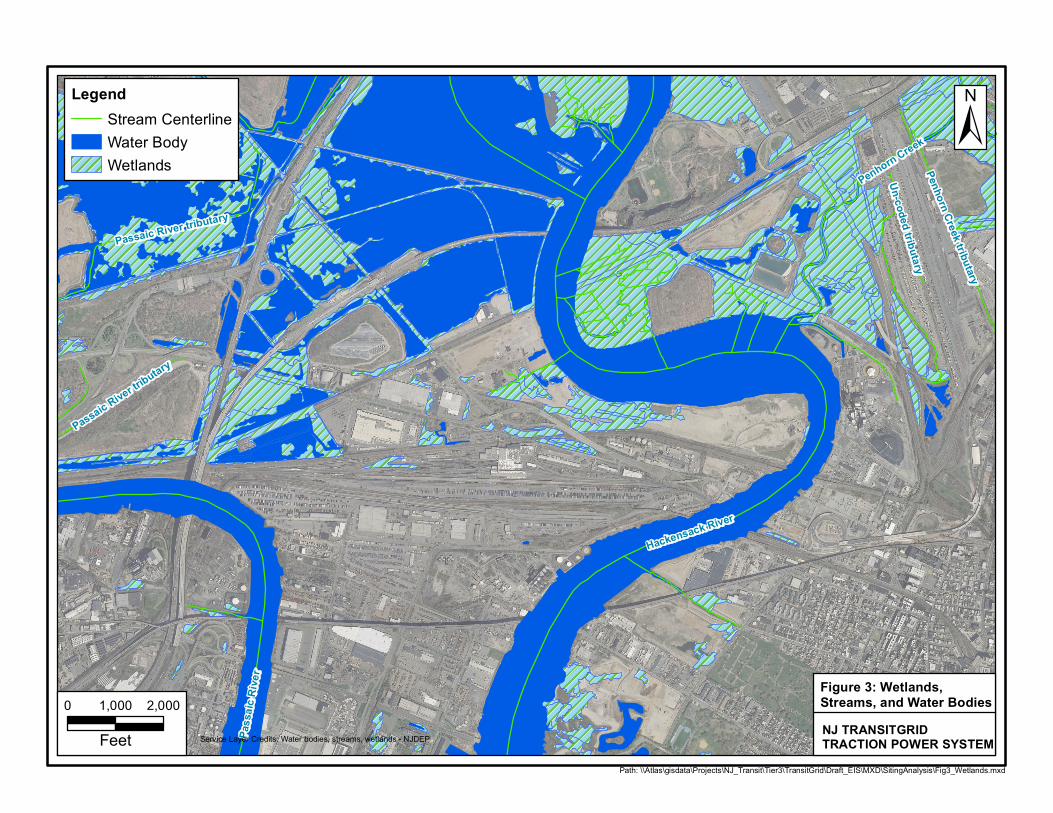
Un-coded tributary
Un-coded tributary
Penhorn Creek
Penhorn Creek
Passaic River tributaryPassaic River tributary
Passaic River tributary
Passaic River tributary
Penhorn Creek tributary
Penhorn Creek tributary
Hackensack River
Hackensack River
Pass
aic R
iver
Pass
aic R
iver
Path: \\Atlas\gisdata\Projects\NJ_Transit\Tier3\TransitGrid\Draft_EIS\MXD\SitingAnalysis\Fig3_Wetlands.mxd
±Legend
Stream CenterlineWater BodyWetlands
0 1,000 2,000
Feet Service Layer Credits: Water bodies, streams, wetlands - NJDEP NJ TRANSITGRIDTRACTION POWER SYSTEM
Figure 3: Wetlands, Streams, and Water Bodies
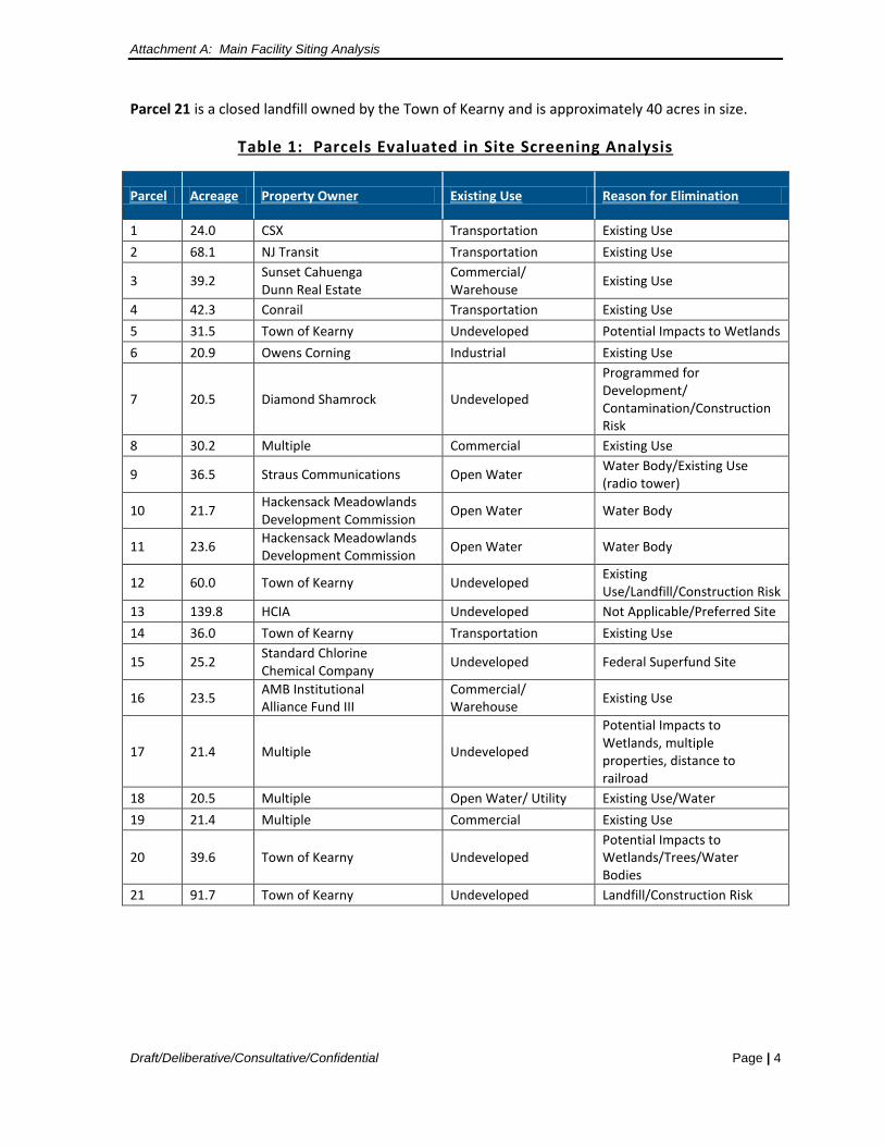
Attachment A: Main Facility Siting Analysis
Draft/Deliberative/Consultative/Confidential Page | 4
Parcel 21 is a closed landfill owned by the Town of Kearny and is approximately 40 acres in size.
Table 1: Parcels Evaluated in Site Screening Analysis
Parcel Acreage Property Owner Existing Use Reason for Elimination
1 24.0 CSX Transportation Existing Use 2 68.1 NJ Transit Transportation Existing Use
3 39.2 Sunset Cahuenga Dunn Real Estate
Commercial/ Warehouse Existing Use
4 42.3 Conrail Transportation Existing Use 5 31.5 Town of Kearny Undeveloped Potential Impacts to Wetlands 6 20.9 Owens Corning Industrial Existing Use
7 20.5 Diamond Shamrock Undeveloped
Programmed for Development/ Contamination/Construction Risk
8 30.2 Multiple Commercial Existing Use
9 36.5 Straus Communications Open Water Water Body/Existing Use (radio tower)
10 21.7 Hackensack Meadowlands Development Commission Open Water Water Body
11 23.6 Hackensack Meadowlands Development Commission Open Water Water Body
12 60.0 Town of Kearny Undeveloped Existing Use/Landfill/Construction Risk
13 139.8 HCIA Undeveloped Not Applicable/Preferred Site 14 36.0 Town of Kearny Transportation Existing Use
15 25.2 Standard Chlorine Chemical Company Undeveloped Federal Superfund Site
16 23.5 AMB Institutional Alliance Fund III
Commercial/ Warehouse Existing Use
17 21.4 Multiple Undeveloped
Potential Impacts to Wetlands, multiple properties, distance to railroad
18 20.5 Multiple Open Water/ Utility Existing Use/Water 19 21.4 Multiple Commercial Existing Use
20 39.6 Town of Kearny Undeveloped Potential Impacts to Wetlands/Trees/Water Bodies
21 91.7 Town of Kearny Undeveloped Landfill/Construction Risk
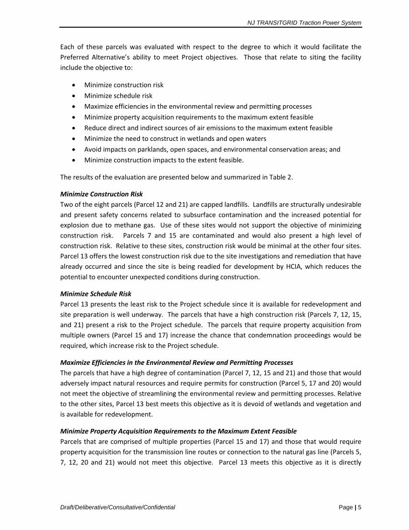
NJ TRANSITGRID Traction Power System
Draft/Deliberative/Consultative/Confidential Page | 5
Each of these parcels was evaluated with respect to the degree to which it would facilitate the Preferred Alternative’s ability to meet Project objectives. Those that relate to siting the facility include the objective to:
• Minimize construction risk • Minimize schedule risk • Maximize efficiencies in the environmental review and permitting processes • Minimize property acquisition requirements to the maximum extent feasible • Reduce direct and indirect sources of air emissions to the maximum extent feasible • Minimize the need to construct in wetlands and open waters • Avoid impacts on parklands, open spaces, and environmental conservation areas; and • Minimize construction impacts to the extent feasible.
The results of the evaluation are presented below and summarized in Table 2.
Minimize Construction Risk Two of the eight parcels (Parcel 12 and 21) are capped landfills. Landfills are structurally undesirable and present safety concerns related to subsurface contamination and the increased potential for explosion due to methane gas. Use of these sites would not support the objective of minimizing construction risk. Parcels 7 and 15 are contaminated and would also present a high level of construction risk. Relative to these sites, construction risk would be minimal at the other four sites. Parcel 13 offers the lowest construction risk due to the site investigations and remediation that have already occurred and since the site is being readied for development by HCIA, which reduces the potential to encounter unexpected conditions during construction.
Minimize Schedule Risk Parcel 13 presents the least risk to the Project schedule since it is available for redevelopment and site preparation is well underway. The parcels that have a high construction risk (Parcels 7, 12, 15, and 21) present a risk to the Project schedule. The parcels that require property acquisition from multiple owners (Parcel 15 and 17) increase the chance that condemnation proceedings would be required, which increase risk to the Project schedule.
Maximize Efficiencies in the Environmental Review and Permitting Processes The parcels that have a high degree of contamination (Parcel 7, 12, 15 and 21) and those that would adversely impact natural resources and require permits for construction (Parcel 5, 17 and 20) would not meet the objective of streamlining the environmental review and permitting processes. Relative to the other sites, Parcel 13 best meets this objective as it is devoid of wetlands and vegetation and is available for redevelopment.
Minimize Property Acquisition Requirements to the Maximum Extent Feasible Parcels that are comprised of multiple properties (Parcel 15 and 17) and those that would require property acquisition for the transmission line routes or connection to the natural gas line (Parcels 5, 7, 12, 20 and 21) would not meet this objective. Parcel 13 meets this objective as it is directly
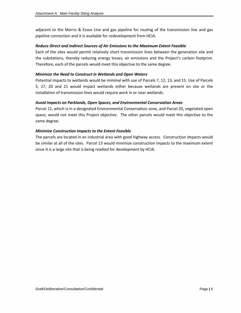
Attachment A: Main Facility Siting Analysis
Draft/Deliberative/Consultative/Confidential Page | 6
adjacent to the Morris & Essex Line and gas pipeline for routing of the transmission line and gas pipeline connection and it is available for redevelopment from HCIA.
Reduce Direct and Indirect Sources of Air Emissions to the Maximum Extent Feasible Each of the sites would permit relatively short transmission lines between the generation site and the substations, thereby reducing energy losses, air emissions and the Project’s carbon footprint. Therefore, each of the parcels would meet this objective to the same degree.
Minimize the Need to Construct in Wetlands and Open Waters Potential impacts to wetlands would be minimal with use of Parcels 7, 12, 13, and 15. Use of Parcels 5, 17, 20 and 21 would impact wetlands either because wetlands are present on site or the installation of transmission lines would require work in or near wetlands.
Avoid Impacts on Parklands, Open Spaces, and Environmental Conservation Areas Parcel 12, which is in a designated Environmental Conservation zone, and Parcel 20, vegetated open space, would not meet this Project objective. The other parcels would meet this objective to the same degree.
Minimize Construction Impacts to the Extent Feasible The parcels are located in an industrial area with good highway access. Construction impacts would be similar at all of the sites. Parcel 13 would minimize construction impacts to the maximum extent since it is a large site that is being readied for development by HCIA.
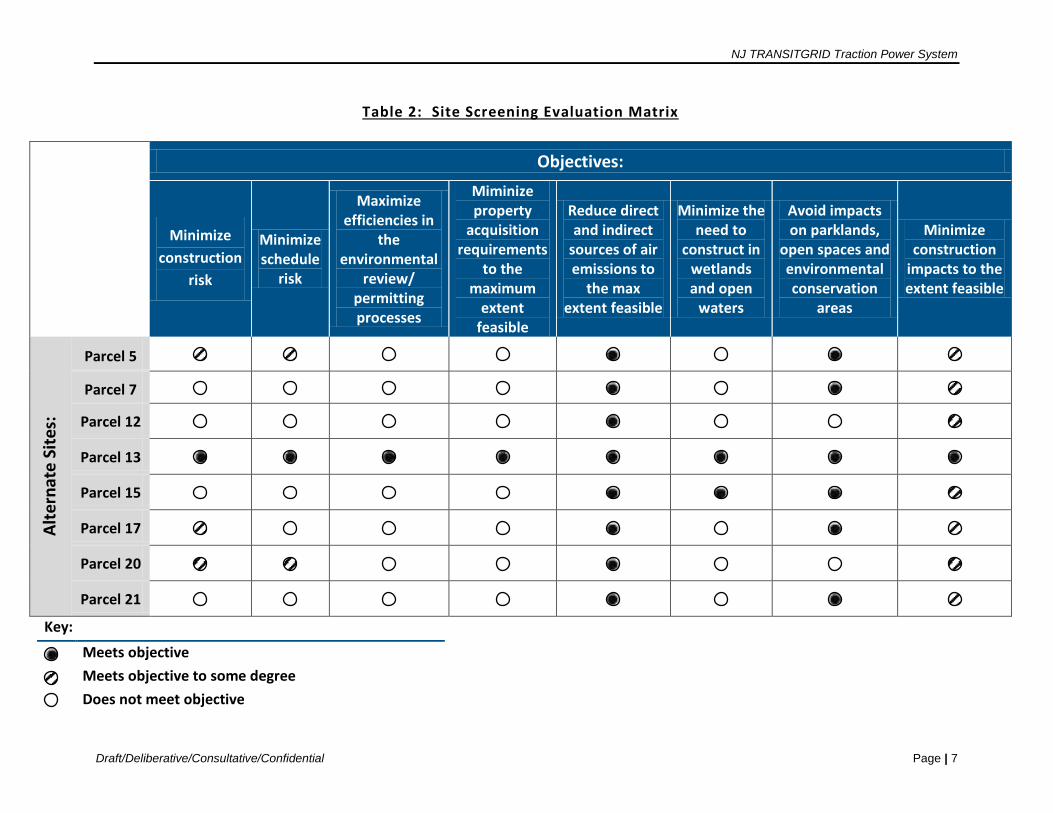
NJ TRANSITGRID Traction Power System
Draft/Deliberative/Consultative/Confidential Page | 7
Table 2: Site Screening Evaluation Matrix
Objectives:
Minimize
construction risk
Minimize schedule
risk
Maximize efficiencies in
the environmental
review/ permitting processes
Miminize property
acquisition requirements
to the maximum
extent feasible
Reduce direct and indirect
sources of air emissions to
the max extent feasible
Minimize the need to
construct in wetlands and open
waters
Avoid impacts on parklands,
open spaces and environmental conservation
areas
Minimize construction
impacts to the extent feasible
Alte
rnat
e Si
tes:
Parcel 5
Parcel 7
Parcel 12
Parcel 13
Parcel 15
Parcel 17
Parcel 20
Parcel 21
Key:
Meets objective
Meets objective to some degree
Does not meet objective
Attachment B
Air Quality Analysis Methodology
Attachment B: Air Quality Analysis Methodology
1
ATTACHMENT B: AIR QUALITY ANALYSIS METHODOLOGY
B.1 Overview
The Preferred Alternative, which will be designed to comply with all applicable Federal and New Jersey regulations, will be evaluated for potential effects on air quality. Federal air quality regulations applicable to a proposed new power generating facility include the EPA Title V, Prevention of Significant Deterioration (PSD), and the Non-Attainment New Source Review (NNSR)/Emissions Offset Rule permitting requirements. EPA has delegated authority to the New Jersey Department of Environment Protection (NJDEP) to administer these programs. Applicable State regulations provided in the New Jersey Administrative Code (NJAC) include SOTA criteria and Reasonable Available Control Technology (RACT) requirements.
EPA has also identified a list of 187 Hazardous Air Pollutants (“HAPs”), which are known or suspected to cause cancer or other serious health or environmental effects. HAPs emitted by the Preferred Alternative will be identified and their potential effects estimated. Federal and state initiatives to address global warming, such as EPA’s Clean Power Plan and New Jersey’s Global Warming Response Act and State Energy Master Plan, will also be addressed and the Project’s consistency with these initiatives evaluated.
B.2 Criteria Pollutants
Several air pollutants have been identified by EPA as being of concern nationwide. These pollutants, known as “criteria pollutants,” are carbon monoxide (CO), nitrogen dioxide (NO2), ozone (O3), particulate matter (PM10 and PM2.5), sulfur dioxide (SO2), and lead (Pb). Ambient concentrations of CO are predominantly influenced by motor vehicle activity. Ozone and ozone precursor emissions are associated with both mobile and stationary sources. NO2 is emitted from both mobile and stationary sources (e.g., industrial facilities, power plants, etc.). Emissions of SO2 are associated mainly with stationary sources. Emissions of particulate matter are associated mainly with stationary sources and diesel-fueled mobile sources (heavy trucks and buses). Lead emissions, which historically were principally influenced by motor vehicle activity, have been substantially reduced, due to the elimination of lead from gasoline. National Ambient Air Quality Standards (NAAQS) and New Jersey Ambient Air Quality Standards (NJAAQS) have established pollutant concentration standards for each of the criteria pollutants to protect human health and welfare.
The Federal Clean Air Act defines nonattainment areas as geographic regions that have been designated as not meeting one or more of the NAAQS; maintenance areas are former non-attainment areas that subsequently demonstrated compliance with the standards; and attainment areas have demonstrated compliance with the standards. The entire State of New Jersey, including Hudson County, is designated as nonattainment for ozone, which is a regional pollutant formed by a reaction over time in the atmosphere between sunlight and NOx and VOC emissions. Hudson County is also designated as a maintenance area for fine particulates (PM2.5) and CO, and an attainment area for NO2, SO2, and coarse particulates (PM10).
Attachment B: Air Quality Analysis Methodology
2
The Draft EIS will include an examination of the impacts of criteria pollutants and regulated non criteria pollutants from the Preferred Alternative on air quality. The Draft EIS will include a description of the existing climate and meteorology of the Project area; an assessment of existing and historical air quality conditions; an inventory of emissions associated with the Project; an assessment of project technology and design; and an estimation of potential air quality impacts.
Applicable Permitting Requirements and Regulations
The NJDEP has implemented an air permitting program to comply with Title V of the Federal Clean Air Act (NJAC). Applicable regulations include Title 7, Chapter 27, Subchapters 8 (Permits and Certificates for Minor Facilities and Major Facilities without an Operating Permit), 18 (Emission Offset Rules), and 22 (Operating Permits). In addition to a Title V Operating Permit, the proposed facility would likely require a PSD and a NNSR permit from NJDEP.
An operating permit is a comprehensive regulatory document that is enforceable. It lists the combustion equipment, air pollution control devices, and the rules and regulations that apply to the facility as well as operational requirements, emission limits, and monitoring requirements. Permitting requirements are determined by the type of source, the operation of the source, the potential emissions, and the location of the facility.
Emission control technologies are required on a pollutant-by-pollutant basis. For example, if a proposed facility is classified as a "major" facility for a pollutant, detailed dispersion modeling as well as the use of lowest achievable emission reduction (LAER) technology (i.e., with no regard to costs) and emission offsets may be required for that pollutant. It is anticipated that NOx and VOC emissions of the proposed facility will exceed NNSR/PSD thresholds, and that offsets will be required for these pollutants.
If, however, the permitted emissions from the plant of another pollutant will be below the threshold limits, less restrictive best available control technology (BACT) requirements will apply to that pollutant. BACT/LAER determinations will be completed for the selected turbine/engine types and sizes based on an analysis of the EPA database of recent permits, and BACT/LAER analyses of recent NNSR/PSD applications. These requirements will be determined by NJDEP on a case-by-case basis.
Applicable Guidance Documents
NJDEP’s Guideline on Air Quality Impact Modeling Analysis, Technical Manual 1002 (November 2009) will be followed to predict the ambient air quality impacts of emissions from the proposed Preferred Alternative. A preliminary modeling protocol will be submitted to NJDEP and EPA for review prior to conducting the modeling analysis and/or a health risk assessment (in accordance with Section 4.1 of the NJDEP Technical Manual 1002). This modeling protocol will be prepared concurrent with the air permit application for the facility, and submitted to the NJDEP Bureau of Technical Services.
Air Quality modeling analyses will comply with the following Federal and New Jersey regulations and guidance documents:
Attachment B: Air Quality Analysis Methodology
3
• PSD air quality impact analysis requirements (40 CFR 52) and PSD increments (40 CFR 51, Appendix W Section 10.2.3.3);
• EPA Guidelines on Air Quality Models (40 CFR Part 51, Appendix W, 2005); • EPA Draft New Source Review Workshop Manual (October 1990); EPA, Guidelines for
Determination of Good Engineering Practice Stack Height (USEPA Technical Support Document for the Stack Height Regulations), Document Number EPA-450/480-023R (June 1995);
• Revised NJDEP Interim Permitting and Modeling Procedures for New or Modified Sources of PM2.5 emissions (December 2010);
• Model Clearinghouse Review of Modeling Procedures for Demonstrating Compliance with PM2.5 NAAQS (February, 2010);
• PSD for Particulate Matter Less Than 2.5 Micrometers (PM2.5) – Increments, Significant Impact Levels (SILs) and Significant Monitoring Concentration (SMC); Final Rule (October 20, 2010 Federal Register); and
• NJDEP Guidance on Risk Assessment for Air Contaminant Emissions (Technical Manual 1003).
Stack Heights
An assessment of optimal stack height will be conducted for the Preferred Alternative. This assessment will take into consideration Good Engineering Practice (GEP) stack heights, air quality related issues, Federal Aviation Administration restrictions, and aesthetic and/or other considerations.
Dispersion Modeling Analyses
With BACT/LAER requirements incorporated into the design of the Preferred Alternative and appropriate stack heights determined, the latest version of the EPA AERMOD dispersion model will be run for multiple scenarios and conditions to determine the potential for significant air quality impacts using conservative modeling assumptions. These analyses will be conducted to determine whether the Preferred Alternative would cause or contribute to a violation of a NAAQS, or consume more of the available increment than is allowed by the PSD rule. Prior to conducting these analyses, a detailed modeling protocol will be developed and submitted to EPA and NJDEP for review.
The following is a brief summary of the approach to air quality modeling that is anticipated.
Pollutants. The following criteria pollutants will be evaluated -- NO2, CO, PM10, and PM2.5. VOC emissions will be also included in this evaluation. Short-term and annual emissions rates will be calculated based on the proposed maximum design capacity of the combustion unit(s) and emission controls, and these values will be compared to applicable major source emission threshold limits (as per N.J.A.C. 7:27-18.4, Tables 2-1 “Major Facility Thresholds” and Table 2-2 “Significant Net Emissions Increase Thresholds”). Emissions under partial loads (50% and 75% of capacity) will also be evaluated to identify the operating conditions that may cause maximum ground-level
Attachment B: Air Quality Analysis Methodology
4
concentrations. In addition, total amounts of hazardous air pollutant (HAPs) emissions will be calculated to determine whether the need for a health risk assessment will be triggered.
Standards/Increments. Predicted short-term and annual pollutant concentrations will be compared to the NAAQS and allowable PSD increments. Modeled PM2.5 concentrations will also be compared to SILs. For those pollutants for which Project impacts exceed the SILs, detailed modeling analyses will be conducted to determine whether the proposed Preferred Alternative will cause exceedances of the NAAQS and PSD increments. Otherwise, no further modeling will be required for those pollutants and the potential impacts will be considered insignificant.
Modeling Approach. Hourly ozone and NO2 background concentrations will be developed from representative monitors over a 5-year period and used in the analysis of NO2 emissions utilizing AERMOD’s Plume Volume Molar Ratio Method module which accounts for the chemical transformation of NO emitted from the stack to NO2 within the source plume. One-hour maximum daily 8th highest NO2 concentration averaged over 5-years period will be produced in a format comparable to the 1-hour NO2 NAAQS (EPA), Memorandum, Additional Clarification regarding Application of Appendix W Modeling Guidance for the 1-hour NO2 NAAQS, 2011. In addition, procedures incorporated into AERMOD for the analysis of PM2.5 will be utilized. Both filterable and condensable emissions will be included.
The Building Profile Input Program, which is included in AERMOD, will be utilized to determine building parameters for incorporating downwash effects and GEP stack height.
Meteorology/Topography. Five years of the latest available meteorological data from Newark Airport representative of the Project Site will be developed using the latest AERMET data that will be adjusted for the site-specific characteristics using AERSURFACE and AERMINUTE models. Topographical and land use factors will be considered.
Background Concentrations. Background pollutant concentrations will be developed based on representative NJDEP monitoring data in the area closest to the Project Site and used to estimate total pollutant concentrations.
Receptors. A receptor network of receptor sites (i.e., locations where pollutant concentrations will be estimated) will be developed using a Cartesian grid around the property site with receptors spaced as follows:
• Around the facility’s property line/fence line in 50 meter (m) increments; • From the property line/fence line to 0.5 kilometers (km) in 50 m increments; • From 0.5 km to 1.5 km from the property line/fence line in 100 m increments; and • From 1.5 km to 3 km (i.e., the approximate 2-mile study area) from the property
line/fence line in 250 m increments.
Actual sensitive land uses (residences, schools, playgrounds, hospitals, etc.) will also be included.
Attachment B: Air Quality Analysis Methodology
5
Mobile Source Analysis
Mobile-source air quality related to employee travel and/or deliveries to and from the Project site will be addressed. Based on the Project location within a CO maintenance area, appropriate Project-related intersections will be reviewed qualitatively to determine whether there would be the potential of Project-related traffic to cause an exceedance of a NAAQS. It is anticipated that the number of Project-generated vehicles would not substantially affect localized CO levels and no detailed CO modeling will be necessary. Therefore, CO will be qualitatively addressed within the NEPA EIS document.
Due to fact that the Project is located within a PM2.5 maintenance area, the potential impacts of Project-related heavy-duty truck traffic will also be reviewed. As detailed in EPA’s Transportation Conformity Guidance for Quantitative Hot-Spot Analyses in PM2.5 and PM10 Nonattainment and Maintenance Areas document released (December 2010), only projects of local air quality concern require quantitative PM2.5 analyses. It is anticipated that the Project will not significantly increase the number of diesel vehicles. Therefore, PM2.5 will also be qualitatively addressed in the Draft EIS.
Construction Impacts
Potential construction-related air quality impacts of the Preferred Alternative will be qualitatively assessed, and mitigation measures will be recommended, as appropriate. Emissions generated by the construction equipment, construction-related vehicles traveling within as well as to and from the Project Site, and the fugitive dust generated by vehicular travel on unpaved construction areas will be considered.
Potential localized impacts on nearby sensitive land uses as well as regional increases in emissions from construction equipment will be discussed. Maintenance and protection of rail traffic during construction, whenever appropriate, will also be addressed.
B.3 Non-Criteria Pollutants.
Non-criteria pollutants, also known as HAPs, may be emitted into the atmosphere from the proposed Preferred Alternative and cause local air quality impacts. HAPs are identified in N.J.A.C. 7:27 - 8 & 22 Subchapter 8, Appendix 1, Table B.
An analysis of HAPs will be performed in accordance with the NJDEP Technical Manual 1003 (“Guidance on Risk Assessment for Air Contaminant Emissions,” 2009). The NJDEP Air Quality Permitting Program utilizes a risk assessment approach to evaluate potential air toxic risk remaining (residual risk) after the application of pollution controls. Based on this guidance document, a risk screening procedure will be conducted as a first step, followed by a comprehensive risk assessment, if necessary.
Eleven air toxic pollutants are emitted, according to Section 3.1.3 of EPA’s AP-42 (Compilation of Air Pollutant Emission Factors), from gas-fired stationary gas-turbines. These are 1.3-butadiene, acetaldehyde, acrolein, benzene, ethyl benzene, formaldehyde, naphthalene, polycyclic aromatic hydrocarbons, propylene oxide, toluene, and xylene. Maximum amounts of these pollutants will be

Attachment B: Air Quality Analysis Methodology
6
estimated using emission factors from AP-42 and the maximum capacity of the combustion turbine. These values will be inserted into NJDEP’s “Division of Air Quality Risk Screening Worksheet for Long-term Carcinogenic and Noncarcinogenic Effects and Short-term Effects,” together with stack height and distance to the property line.
A first-level screening analysis will initially be conducted that will use generalized worst-case assumptions and worksheet calculations to estimate cancer and noncancer risks from the inhalation of emissions proposed in a permit application. In place of dispersion modeling, “air impact values” (as provided in the Worksheet) will be used to estimate pollutant concentrations. For each contaminant, incremental cancer risks and hazard quotients (ratios of predicted concentrations to the guideline values) will be estimated and compared to applicable short-term and long-term (chronic exposure) guideline concentrations, which are reference concentrations for noncarcinogenic pollutants and unit risk factors for long-term exposure to carcinogenic pollutants.
If a source fails the first-level risk screening by exceeding the risk guidelines, a detailed modeling analysis will be conducted to more accurately estimate ambient air concentrations by using stack- and source-specific data and representative meteorological data. The EPA dispersion model (AERMOD) that will be used to estimate criteria pollutant concentrations will be used in this evaluation. Prior to performing comprehensive risk assessment, a modeling protocol will be prepared and submitted to NJDEP for approval.