Embed Size (px)
Citation preview

NOAA
NOAA
FAA-NWS Aviation Weather Weather Policy and Product Transition PanelFriends and Partners in Aviation Weather
October 22, 2014

NOAA
Airplanes …
Lockheed Constellation Airbus A380
have changed.
NOAA
Aviation weather products …
not so much.
Area Forecast 2013Area Forecast 1965

NOAA
• Many NWS aviation weather products are decades old, with little change in format
• The Area Forecast (FA) is a prime example
• FAA and NWS have undertaken a review of all weather information produced by NWS for aviation purposes
Background
NOAA
Primary goals of the review, include:• Improving NWS products, in-support of aviation weather;• Increasing emphasis on digital products and looking for
opportunities to digitize legacy NWS products and services;• Identifying products and services with duplicative information;• Identifying products and services that are of limited (dated)
utility to operators; and • Focusing activities of NWS forecasters to maximize
operational benefit.
Background

NOAA
• Manually-generated text product (no graphical components)
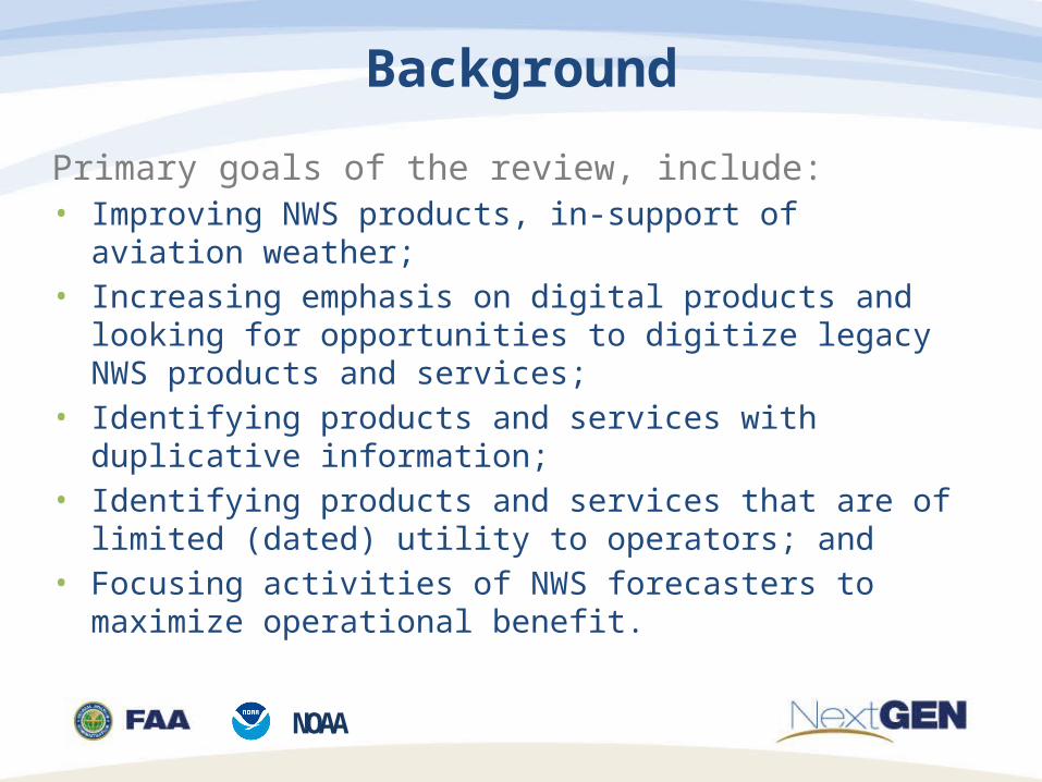
• Forecasts VFR clouds and weather over 16 vast geographical areas:
CONUS (6) Hawaii (1) Alaska (7) Gulf of Mexico (1) Caribbean (1)
• Issued 3-4x daily, valid 18hrs (12hr + 6hr categorical outlook)
• Character-limited• Variations date back as far as the 1930s; current version
unchanged since the early 1990s
The Area Forecast (FA)
NOAA
Geographical Coverage of the FA

NOAA
Elements of the FA & Alternatives
Elements of the FA
Weather Synopsis
Cloud Amount (1000ft ≤ Z ≤ FL180)
Cloud Bases & Tops (1000ft ≤ Z ≤ FL180)
Areas of Precipitation
Visibility (including obstruction)
Areas of Sustained Surface Winds
Flight Category* (including obstruction)
Alternative Sources of Information
*6hr outlook (hrs 12-18)
WPC+HFO Surface Analyses + Progs(including Short-Range Public Forecast Discussion)
National Digital Forecast Database (SkyCover Grid)Low-Level SIGWX Chart + PIREPsCloud Top Height Model Forecast Graphics
National Digital Forecast Database (PoP Grid)Low-Level SIGWX Chart
AIRMET Sierra
National Digital Forecast Database (Sfc Winds Grid)AIRMET Tango
Low-Level SIGWX Charts + Nearest TAF(s)

NOAA
FA Alternatives Guide
Low-Level Significant Weather (SIGWX) Prognostic Charthttps://www.aviationweather.gov/progchart/low
Low-Level SIGWX Prognostic Chart, SFC-FL240.Aviation Weather Center
Guidance: The SIGWX chart provides pilots with the ‘big picture.’ Cold, warm, occluded and stationary fronts are clearly depicted, along with areas of high and low pressure.

NOAA
FA Alternatives GuideNational Digital Forecast Database (NDFD):http://graphical.weather.gov/sectors/conus.php
Guidance: Whereas SIGWX charts provide pilots with a big-picture, general depiction of the weather, NDFD provides much greater detail with finer time scales and finer areal depictions of weather. FAA and NWS are working to ensure the information in the NDFD is available through existing FAA pilot weather briefing sources. AWC is integrating this information with ADDS, so users are able to generate a weather briefing without the need to navigate multiple websites.
NDFD Surface Wind Speed and Direction Grid, CONUS & Regional Views.National Weather Service

NOAA
FA Alternatives GuideCloud Top Height Model Forecast Graphic:http://www.emc.ncep.noaa.gov/mmb/mmbpll/opsnam/
Guidance: The Cloud Top Height Model Forecast Graphic is a computer-generated forecast from one of many weather computer models used by the National Weather Service. The Cloud Top Height Forecast Graphic only indicates the highest cloud. In other words, if there are multiple cloud layers, this product will only provide the top of the highest cloud. It should be used in-conjunction with METARs and TAFs to assess the presence of low, medium or high clouds.
Cloud Top Height Model Forecast Graphic.National Center for Environmental Prediction (NCEP)

NOAA
Area Forecast Status Update
• FAA and NWS mapped alternative sources of information, to be used in-place of the FA
• Developed guidance document for using these alternatives, including examples
• Invited interested parties to submit comment• Notice in the Federal Register (FAA)• Public Information Statement (NWS)• Majority of comments in support of transition
• The Agencies are targeting mid 2015 for transition to alternative sources of information
• Initial change(s) will apply only to the CONUS and HI FAs
• AK, CB and GM FAs will be addressed at a later date

NOAA
Federal AviationAdministration
Stewart StepneySystems Engineer
NextGen Aviation Weather DivisionAdv. Concepts & Technology Development
(202) [email protected]
National Oceanic andAtmospheric Administration
Kevin StoneMeteorologist
Aviation Services BranchNational Weather Service
(301) 713-1726 [email protected]
Questions or comments?Please contact:

NOAA
NOAA