Embed Size (px)
Citation preview
October 2016
Nogoa Mackenzie Water Scheme The Nogoa Mackenzie Water Supply Scheme was established in 1968 to meet agricultural and mining developments and the water requirements of urban communities in the Central Highlands.
The central feature of the scheme is the conservation of water of the Nogoa River by Fairbairn Dam, near Emerald. The storage for the dam is known as Lake Maraboon, with the Selma, Bedford, Bingegang and Tartrus weirs below it on the Mackenzie River.
FAIRBAIRN DAM Fairbairn Dam is built across the Nogoa Gap about 19 kilometres upstream (south) of the town of Emerald, in Queensland’s central west.
Work on the dam commenced in 1968 and was completed in December 1972. Storage of water commenced in January 1972 and the dam filled and overflowed for the first time two years later.
Channel/Pipeline System Water is diverted from Fairbairn Dam to two channel systems to customers via a network of mostly open-earth channels.
Selma Channel System The Selma Channel System supplies water to the left bank, west and north of Emerald.
• Design capacity: 610 ML/day • Length of main channel: 46.7km
• Length of subsidiary channels: 26.8km
The left bank outlet which releases water into the Selma Channel System is at a relatively high level and a pump station is required to lift water into the outlet channel for peak demand periods when the storage level falls. The pump station is located in the left bank wall of the spillway and is equipped with three variable discharge pumps.
Weemah Channel System The Weemah Channel System supplies water to the right bank irrigation area east of Emerald.
• Design capacity: 300 ML/day
• Length of main channel: 52.6km
The right bank outlet which releases water into Weemah Channel and the Nogoa River consists of a 6 metre diameter tunnel with an intake tower housing control gates at the upstream end. The tunnel was used to divert the river during construction of the dam.
Surface drainage systems are in place to provide drainage services in the area. The total length of drains is 204 kilometres.
The distribution system has around 150 customers. (Source: www.sunwater.com.au/schemes/nogoa-mackenzie)
Fairbairn Dam Snapshot • Stream name: Nogoa River • Lake name: Lake Maraboon • Structure: Earth-fill embankment • Storage level above original bed: 31.7 metres • Storage capacity: 1,301,000 megalitres • Surface area at full supply: 15,000 hectares • Pump stations: 4 • Year completed: 1972 • Owned and managed by SunWater Pty Ltd • The Fairbairn dam is Queensland’s second largest
water storage after the Burdekin Falls (1,860,000 ML).
October 2016
USES OF WATER
Irrigation The main crops irrigated are cotton, citrus (mandarins, oranges and lemons) and grapes. Other crops irrigated include wheat, chickpeas, mungbeans, sorghum, maize, lucerne, melons and macadamias.
Other important irrigated agricultural regions include the Comet River and “Big Bend” (Mackenzie River) where irrigation infrastructure is privately owned and constructed, and water is collected and stored in off-stream storages.
Irrigated land is a limited and valuable resource comprising only 1.2% of total land use in Central Queensland. From this small area of land use, approximately 15% of the total value of agricultural production in Central Queensland is produced (ABS 2012; ACARP 2012).
Urban Water Supplies Water from Fairbairn Dam is released down the Nogoa River to the Selma Weir for supply to the town of Emerald. Supplies are diverted by pipelines to the towns of Blackwater, Bluff, Tieri, Dysart and Middlemount.
Industrial Water from Fairbairn Dam is released to supply coal mining developments on the Bowen Basin.
SunWater’s Blackwater Pipeline provides water to several mines and the town of Blackwater. Several other pipelines owned by mines divert water from the scheme to support various mining operations. (Source: www.sunwater.com.au/schemes/nogoa-mackenzie)
SCHEME WATER USE STATISTICS (2015/16) Customer Segment
No. of Customers
Water Entitlements (ML)
Available Water (ML)
Available Water (%)
Water Deliveries (ML)
Water Deliveries (%)
Temporary Transfer Purchase Volume (ML)
Industrial 29,420 26,663 12,282 160
Irrigation 160,132 204,613 160,988 69,217
Urban 8,548 7,793 6,794 12
Other 331 343 213 4
SunWater 32,090 30,537 11,748 4
Total 393 230,520 253,963 110 157,152 68 60,216 (Source: SunWater Annual Report 2015-2016 Pg 77)
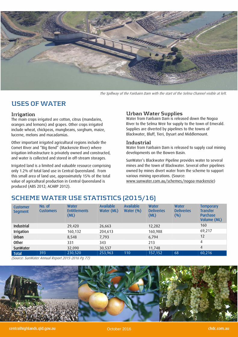
The Spillway of the Fairbairn Dam with the start of the Selma Channel visible at left.
October 2016
(Source: SunWater October 2016)
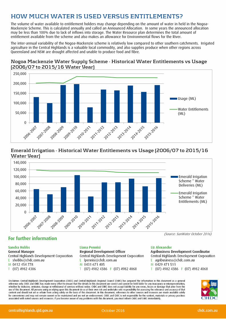
HOW MUCH WATER IS USED VERSUS ENTITLEMENTS? The volume of water available to entitlement holders may change depending on the amount of water in held in the Nogoa-Mackenzie Scheme. This is calculated annually and called an Announced Allocation. In some years the announced allocation may be less than 100% due to lack of inflows into storage. The Water Resource plan determines the total amount of entitlement available from the scheme and also makes an allowance for Environmental flows for the River.
The inter-annual variability of the Nogoa-Mackenzie scheme is relatively low compared to other southern catchments. Irrigated agriculture in the Central Highlands is a valuable local commodity, and also supplies produce when other regions across Queensland and NSW are drought affected and unable to produce food and fibre.
Nogoa Mackenzie Water Supply Scheme - Historical Water Entitlements vs Usage (2006/07 to 2015/16 Water Year)
Emerald Irrigation - Historical Water Entitlements vs Usage (2006/07 to 2015/16 Water Year)
0
50,000
100,000
150,000
200,000
250,000
Usage (ML)
Water Entitlements(ML)
0
20,000
40,000
60,000
80,000
100,000
120,000
140,000
Emerald IrrigationScheme * WaterDeliveries (ML)
Emerald IrrigationScheme * WaterEntitlements (ML)

#
#
#
#
#
*
*
*
*
*
#
#
#
#
#
#
#
#
#
##
#
#
#
##
#
#
#
#
#
#
#
##
#
#
#
#
!
!
!
!
!
!
!
!
!
!
!
!
!
!
!
!
!
!
!
!
!
!
!
Woleebee Creek ToGlebe Weir Pipeline
StanwellPipeline
Tarong Pipeline
Eungella Water PipelineSouthern Extension
Awoonga Callide PipelineStag CreekPipeline
Blackwater Pipelines
DAWSON VALLEY WSS
LOWER FITZROY WSS
BOYNE RIVER & TARONG WSS
THREE MOON CREEK WSS
CALLIDE VALLEY WSS
NOGOA MACKENZIE WSS
Cania Dam
Wuruma Dam
Callide DamKroombit Dam
Fairbairn Dam
Boondooma Dam
Avis Weir
Kirar Weir
Glebe Weir
Moura Weir
Jones Weir
Monto Weir
Selma Weir
Bazley Weir
Gyranda Weir
Bedford Weir
Tartrus Weir
Theodore Weir
Youlambie Weir
Mulgildie Weir
Bingegang Weir Eden Bann Weir
Stag Creek Weir
John Goleby WeirOrange Creek Weir
Callide Creek Weir
Neville Hewitt Weir
Gyranda Weir Anabranch
Moura Offstream Storage
Theodore Weir Anabranch
Neville Hewitt Weir Anabranch
CLARE
ALPHA
TAMBO
TAROOM
BILOELA
EMERALD
YEPPOON
EIDSVOLD
DUARINGA
CLERMONT
ROLLESTON
GLADSTONE
MUNDUBBERA
BLACKWATER
SPRINGSURE
MARLBOROUGH
ST LAWRENCE
ROCKHAMPTON
Belyando River
Dawson River
Ward River
Isaac River
Comet Rive r
Fitzroy River
Roper Ck
Nive River
Maran
oaRiver
Barcoo River C lematis Ck
Sand
y Ck
Bedurie
Ck
Cannon Ck
Meriv
aleRiv
er
Nogoa River
Mackenzi
e River
Fairbairn Dam
Warrego River
Lang lo River
Alice River Fairb
airn D
am
Dawson River
Warre
go River
Nive Riv
er
Merivale River
Come
t Rive
r
Maranoa River
Warrego River
Warrego
River
CENTRAL HIGHLANDS REGIONAL COUNCIL
151°0'0"E
151°0'0"E
150°0'0"E
150°0'0"E
149°0'0"E
149°0'0"E
148°0'0"E
148°0'0"E
147°0'0"E
147°0'0"E
146°0'0"E
146°0'0"E
23°0
'0"S
23°0
'0"S
24°0
'0"S
24°0
'0"S
25°0
'0"S
25°0
'0"S
26°0
'0"S
26°0
'0"S
5
DRAWING No. 247289 A
Coordinate System: Geocentric Datum of Australia (GDA94).
0 15 30 45 60 75 km 1:1,750,000
SCALES (A3 SIZE)
MAP INFORMATION
SUNWATER WATER SUPPLY SCHEMESWITHIN CENTRAL HIGHLANDSREGIONAL COUNCIL BOUNDARYLOCATION PLAN
LEGEND! Towns
SunWater Storages Infrastructure# Dam
# Offstream Storage
# Balancing Storage
# Weir#* Anabranch Weir# Barrage
State Roads
SunWater Pipelines
Lakes (Water Storages)
SunWater Regulated Stream
Council Boundary
SunWater Channel Systems
Qld Built Up Areas
While
every c
are is
taken
to ensu
re the
accur
acy of
this pr
oduct,
SunW
ater m
akes n
orep
resent
ations
or wa
rrantie
s abo
ut its
accura
cy, re
liability
, com
pleten
ess o
rsui
tability
for a
ny par
ticular
purpos
e and
discla
ims al
l respo
nsibili
ty and
all lia
bility
(includ
ing wi
thout l
imitati
on, lia
bility i
n negl
igence
) for a
ll expe
nses, l
osses,
dama
ges(inc
luding
indire
ct or
conseq
uential
dama
ge) an
d cost
s whic
h you
might
incur
as a
result
of the
produ
ct bein
g inacc
urate
or inc
omple
te in
any wa
y and
for an
y reas
on.Do
cument
: S:\B
W As
set De
livery\G
IS_Da
ta\Ente
rprise
_GIS\
Corpo
rate_M
apping
\Draw
ings\A
rcMap\
247289
-A.mx
dPri
nted: T
hursda
y, 20/1
0/2016
01:36
:38 PM