Embed Size (px)
Citation preview

The NORBIT iLiDAR is the most compact terrestrial mapping sensor fully integrated with a high resolution bathymetric multibeam system. With 300k data points per second it is an ideal tool for mapping above water surface terrain for a complete picture from a single pass. A robust single cable connects the IP67 iLiDAR sensor head to the topside Sonar Interface Unit (SIU) – with fewer connections, a rapid integration and compact size, surveys are easily carried out from any sized platform by personnel with minimal expertise.
NORBIT’s iLiDAR laser is an all-new multi-sensing concept that combines multiple tightly integrated sensors into one hardware platform with a single LAN connection to survey laptop. Supported sensors include any combination of bathymetric multibeam echo-sounder, forward looking sonar, forward looking bottom detection and iLiDAR. Allowing you to...
Explore more with Norbit
NORBIT iLiDAR LASER
DATASHEET - PS-150008-3
EXPERTS in sensor equipment providing telemetry and communication solutions for harsh environments. NORBIT develops and delivers innovative products - allowing you to explore more.
Turnkey Integrated Mobile LiDAR SystemFor Complete Above Water Point Cloud
www.norbit.com
Features ✓ Built For Marine Environment
✓ Hardware Time Synchronization
✓ Fully Integrated With iWBMS
✓ Robust Hardware Time Synchronization
✓ Single Cable Integration
✓ 360 Deg Field View
✓ Less Than 3 Kg
Applications ✓ Harbor Surveys
✓ River Surveys
✓ Height Clearance (Transmission Lines, Bridges, Etc.
✓ Beach Nourishment Surveys
✓ Shoreline Charting Surveys
✓ Aquaculture
Options ✓ Senior Hydrographer for
Support and Training
✓ Laptop
✓ Turnkey Survey Solutions
✓ Pole Mount And Travel Option
✓ Top-end INS (Roll, Pitch & Heading 0.01deg)
✓ Acquisition, Navigation & Post Processing Software
✓ Can be Delivered with all major software packages e.g. HYPACK, QINSy, EIVA, CARIS, etc.
PRELIMINARY
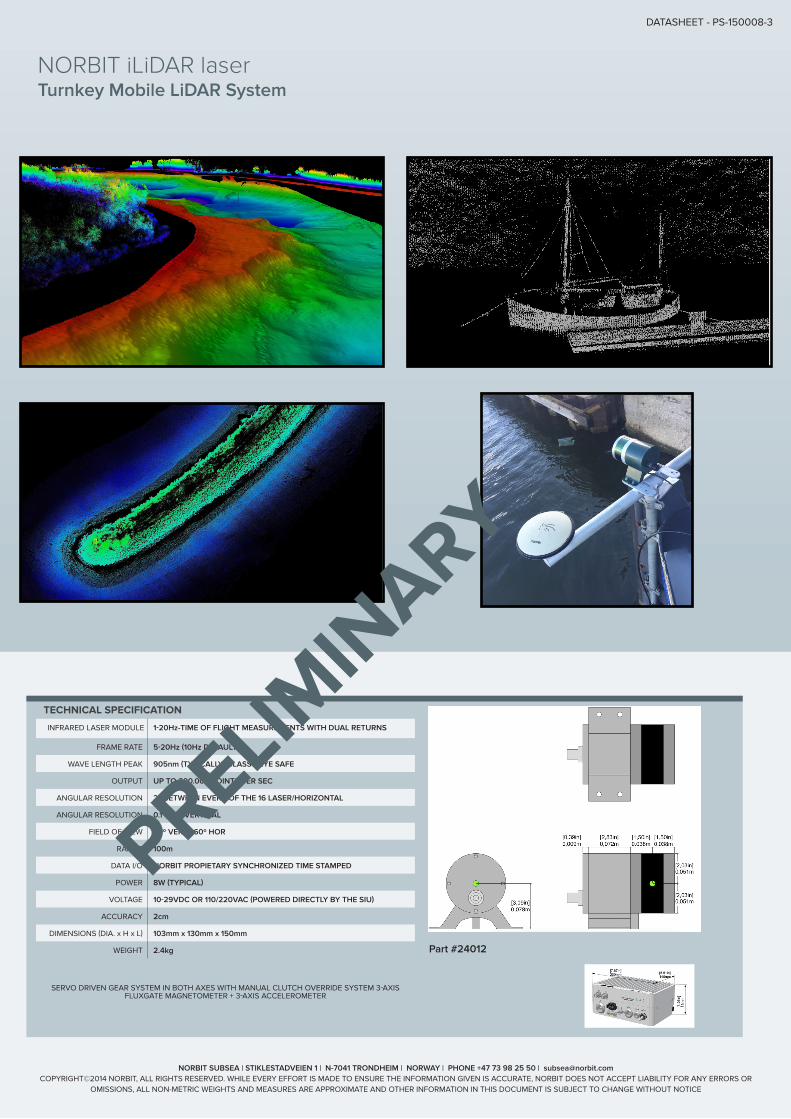
SERVO DRIVEN GEAR SYSTEM IN BOTH AXES WITH MANUAL CLUTCH OVERRIDE SYSTEM 3-AXIS FLUXGATE MAGNETOMETER + 3-AXIS ACCELEROMETER
NORBIT SUBSEA | STIKLESTADVEIEN 1 | N-7041 TRONDHEIM | NORWAY | PHONE +47 73 98 25 50 | [email protected] COPYRIGHT©2014 NORBIT, ALL RIGHTS RESERVED. WHILE EVERY EFFORT IS MADE TO ENSURE THE INFORMATION GIVEN IS ACCURATE, NORBIT DOES NOT ACCEPT LIABILITY FOR ANY ERRORS OR
OMISSIONS, ALL NON-METRIC WEIGHTS AND MEASURES ARE APPROXIMATE AND OTHER INFORMATION IN THIS DOCUMENT IS SUBJECT TO CHANGE WITHOUT NOTICE
Turnkey Mobile LiDAR System
DATASHEET - PS-150008-3
NORBIT iLiDAR laser
Part #24012
TECHNICAL SPECIFICATION
INFRARED LASER MODULE 1-20Hz-TIME OF FLIGHT MEASUREMENTS WITH DUAL RETURNS
FRAME RATE 5-20Hz (10Hz DEFAULT)
WAVE LENGTH PEAK 905nm (TYPICALLY) CLASS 1 EYE SAFE
OUTPUT UP TO 300.000 POINTS PER SEC
ANGULAR RESOLUTION 2º BETWEEN EVERY OF THE 16 LASER/HORIZONTAL
ANGULAR RESOLUTION 0.1º-0.4º VERTICAL
FIELD OF VIEW 30º VER., 360º HOR
RANGE 100m
DATA I/O NORBIT PROPIETARY SYNCHRONIZED TIME STAMPED
POWER 8W (TYPICAL)
VOLTAGE 10-29VDC OR 110/220VAC (POWERED DIRECTLY BY THE SIU)
ACCURACY 2cm
DIMENSIONS (DIA. x H x L) 103mm x 130mm x 150mm
WEIGHT 2.4kg
PRELIMINARY