Embed Size (px)
Citation preview

North Branch of the Chicago River SCS Curve Number Generation
This technical memorandum describes HDR’s approach for generating SCS Curve Number data
for the watersheds comprising the North Branch of the Chicago River (herein referred to as the
“North Branch”).
1. Approach
Previous approaches for Detailed Watershed Plan (DWP) SCS curve number generation are the
“Calumet-Sag Watershed SCS Curve Number Generation” technical memoranduma authored by
CH2M Hill (dated August 14, 2007 and herein referred to as the “CH2M Hill Memo”) and
“Comments on CH2MHill Curve Numbers”b email authored by CTE (dated September 14, 2007
and herein referred to as the “CTE email”). HDR will incorporate these approaches, with the
following changes or refinements:
o The use of an additional Natural Resources Conservation Service (NRCS) soil survey for
the City of Chicago;
o Analysis of the affects of minor soil types;
o Review and revisions of land use information;
o Use of existing remote sensing datasets to estimate impervious areas;
o GIS dataset preparation.
2. NRCS Soil Survey
The CH2M Hill Memo noted that NRCS soils datasets covered portions of the watersheds but
did not include the City of Chicago. In place of this, the CH2M Hill Memo recommended
assuming a uniform hydrologic soil group (HSG) of “C”, representing moderately high runoff
potential soils. The NRCS provides two types of soil datasets for the area. One type is the Soil
Survey Geographic, or SSURGO, datasetc. The SSURGO dataset is available for select areas and
is a detailed soil survey. The City of Chicago is not included in the SSURGO dataset, although
portions of the North Branch upper basin are included.
A second type of soils dataset developed by the NRCS is the U.S. General Soil Map (formerly
the State Soil Geographic dataset), also known as STATSGO or STATSGO2d. STATSGO is
more general than SSURGO and is based on a wide range of available soil literature. The City of
Chicago and portions of the North Branch lower basin are mapped in the STATSGO dataset.
Figure 1 shows combined SSURGO and STATSGO soils information for the North Branch. The
SSURGO dataset areas in the upper basin (the Skokie River, Upper North Branch, and a portion
of the West Fork) are at a smaller, more refined scale than STATSGO. While SSURGO is the
a pw://pwappoma001:NorthCentral_Omaha/Documents/D{6758c9b5-6371-46df-b1c9-ebcb8deb7223}
b pw://pwappoma001:NorthCentral_Omaha/Documents/D{8a9f643d-bd6c-496d-b4c7-c6e97ea73e08}
c http://soils.usda.gov/survey/geography/ssurgo/
d http://soils.usda.gov/survey/geography/statsgo/

preferred dataset, the additional use of STATSGO in the lower basin shows soils with HSG
ranging from “A” (low runoff potential) to “C” (moderately high runoff potential). The
STATSGO soil dataset will be used to supplement SSURGO data, rather than assuming a
uniform soil type.
3. Minor Soil Types
The HSG designations of soils within the North Branch watershed are a key input to hydrologic
modeling. Within each SSURGO or STATSGO GIS database, the NRCS has developed
polygons (map units) that group soils. NRCS states:
Map Unit Delineations are closed polygons that may be dominated by a
single soil or miscellaneous area component plus allowable similar or
dissimilar soils, or they can be geographic mixtures of groups of soils or
soils and miscellaneous areas.e
This does not mean that each map unit represents a homogenous (that is, the same) soil type.
Instead, there may be multiple soil types (called soil components) occurring within a given map
unit. The map unit is a common geographic feature that can potentially contain many different
types of soils.
In most cases, each map unit will have a single HSG designation. This occurs when a single soil
component is predominant (generally making up 90% or more of the map unit) or when the
multiple soil components all have the same or similar HSG characteristic. The default soil
database query will select this predominant HSG classification for use in hydrologic modeling.
There can be cases where there are significant soil variations that require further examination to
determine a proper HSG classification.
e Metadata for Soil Survey Geographic (SSURGO) database for Cook County, Illinois, March 2007.

Figure 1. Combined SSURGO and STATSGO Soils for the North Branch

As an example, consider the soil report for map unit 989A in Figure 2. The Elliot soil component
is HSG “C” and makes up 45% of the map unit, while the Mundelein soil is HSG “B” and makes
up an additional 45% of the map unit. The remaining 10% of the map unit is split between two
other soil components (Ashkum and Pellla) of HSG C and B respectively. As a map unit is the
basic descriptive area, there is no further additional information within GIS that indicates the
distribution of the B and C HSG soils. The default GIS query is to report the map unit as HSG C,
only because the Elliot soil appears before the Mundelein soil in the database.
A technique is required to determine a single HSG for each map unit. The goal of the technique
is to 1) improve hydrologic modeling accuracy by weighting the aggregate HSG in favor of a
predominant value, and 2) to provide consistent and defensible HSG classifications.
Figure 2. Example NRCS Soil Map Unit
In classifying a HSG for a given soil, the NRCS uses various soil parameters as documented in
Chapter 7 of the Hydrology chapter in the National Engineering Handbook (NRCS, May 2007).
Essentially, two parameters are used in HSG classification: 1) the depth to a water impermeable
layer, such as clay or bedrock, or high water table; and 2) the most restrictive saturated hydraulic
conductivity within the first 40 inches of the soil column. Figure 3 provides the decision matrix
used in HSG classification.
The first step in the HSG assignment is to determine if the water impermeable layer or high
water table is less than 40 inches from the surface. This information can be obtained from the
NRCS soil database “Soil Features” and “Water Features” reports, or as a narrative from the
“Map Unit Description” report. When the Map Description Report for map unit 989A is
reviewed (Figure 4), the Elliot soil has root restrictive layer of approximately less than 40 inches.

The soil also has a water table for more than one month of the year at a depth of less than 40
inches. The Mundelein soil root restrictive depth is more than 60 inches but has a high water
table of less than 40 inches. The NRCS Table 7-1 criteria are applied for both soils.
Figure 3. NRCS HSG Classification Criteria

Figure 4. Example NRCS Map Unit Description Report
Next, the range of most restrictive saturated hydraulic conductivity is determined. The most
restricted layer is the layer having the lowest saturated hydraulic conductivity. Based on NRCS
criteria only the first 40 inches of the soil profile are considered, regardless of the depth to the
impermeable layer. This information is provided in the NRCS “Physical Soil Properties” report.
Figure 5 shows an example report for map unit 989A. The most restricted saturated hydraulic
conductivity for the Elliot soil is 0.42 to 4.23 µm/sec with a midpoint value of 2.32 µm/sec. For
Mundelien it is 4.23 to 14.11 µm/sec, with a midpoint value of 9.17 µm/sec.

Figure 5. Example NRCS Physical Soil Properties Report
Referring to NRCS Table 7-1, the saturated hydraulic conductivity of the Elliot soil partially falls
into the HSG C and D range and Mundelien falls into HSG B and C. A weighted saturated
hydraulic conductivity using each soils’ midpoint values and the percent of map unit is
calculated. For the map unit 989A example this is:
[(0.45 * 2.32 µm/sec) + (0.45 * 9.17 µm/sec)] / (0.45 + 0.45) = 5.74 µm/sec
The weighted value in this case falls into HSG C. The map unit is characterized as HSG C
indicating that under the high water table conditions both soils are closer to a HSG C than HSG
B.
When a soil component is classified as a drained and undrained HSGf, this approach will be
applied to both cases. The first weighted average will include the drained component assuming
that the water table and impermeable layer is more than 40 inches from the surface. The second
weighted average will use the undrained component assuming that the water table and
impermeable layer is less then 40 inches. This will produce a weighted HSG classification with
drained and undrained elements.
Figure 6 provides a flowchart illustrating the weighting approach.
f For example, a B/D HSG classification indicates the soil acts as HSG B under drained conditions and HSG D under
undrained conditions.

Figure 6 - HSG Weighting Flowchart

Based on this weighting approach, HDR reviewed and weighted the HSG for soil map units
within the North Branch watershed. The NRCS map units in Table 1 were adjusted. Figure 7
and Figure 8 provide the HSG classifications over the North Branch basin for drained and
undrained conditions, respectively.
Table 1. Adjusted Soil HSG Based on Multiple Soil Components
Map Unit Original HSG Adjusted based on Soil Components
Drained HSG Undrained HSG
840B B and C C C
840C2 C and B C C
923B C and B/D C C
924 B/D and C C C
925B C and D D D
926B B/D and B B C
978A C and B C C
978B C and B C C
979A B and C C C
979B B and C C C
981A B and D C C
981B B and D C C
982A B and D C C
982B B and D C C
983B B and D C C
989A C and B C C
s2247 B/D and B B C
s2279 C and D D D
s2281 C and B/D C C
s2303 B/D and C B C
s2304 C and B/D C C
s2305 A and B/D A B

Figure 7. Drained Soil Classifications

Figure 8. Undrained soil classifications

4. Land Use Information
The primary land use information used by HDR is the 2001 Land-use Inventory published by the
Chicago Metropolitan Agency for Planning (CMAP), which was formerly the Northeastern
Illinois Planning Commission (NIPC). CMAP publishes spatial land use information every five
years, with the 2001 data (published May 2006) being the most recent at the time of this writingg.
The CMAP dataset was developed at a scale of 1:24,000. The dataset was compiled using a
variety of reference sources, including aerial photographs, georeferenced plat books, commercial
datasets of shopping and manufacturing areas, and state, county, and city natural resources
databases. Each area in this dataset is coded with a number representing type of land use. The
overall classes of land use are:
o 1100 Series - Residential
o 1200 Series - Commercial and Services
o 1300 Series - Institutional
o 1400 Series - Industrial, Warehousing and Wholesale Trade
o 1500 Series - Transportation, Communication, and Utilities
o 2000 Series - Agricultural Land
o 3000 Series - Open Space
o 4000 Series - Vacant, Wetlands, or Under Construction
o 5000 Series - Water
A visual review of the CMAP dataset was performed by comparing the 2001 landuse data to
2007 aerial imageryh. Any land use data not matching the aerial information was revised to
accurately represent land use conditions throughout the watershed. HDR found many parcels
coded in the 4200 series (residential construction) that have since been developed to the 1100
series (residential). There were also some parcels in the 2000 series (agricultural) that appeared
to be miscoded or subsequently developed. These were changed to various different land use
types including residential, open space, retail center, and golf course. Table 2 summarizes the
revised land uses made by HDR to the CMAP dataset. The total adjusted area amounts to 3.0
mi2, or approximately 1.5% of the basin area. Table 3 summarizes the total land uses in the basin
based on 2007 data, while Figure 9 maps this land use data.
g 2005 land use data was published by CMAP on January 2009. However, HDR had already updated the 2001 data
to 2007 conditions by this time. h USDA-FSA Aerial Photography Field Office, File "ortho_1-1_1n_il031_2007_1", Published August 23, 2007.

Table 2. HDR Revised Land Uses (Subset of CMAP dataset)
Revised Land Use Revised Basin Area
As of 2001 As of 2007 [mi2]
1110 (RES/SF) 3100 (OPENSP REC) 0.002
1350 (RELIGOUS) 1110 (RES/SF) 0.037
1520 (OTH LINEAR TRAN) 1223 (BUS. PARK) 0.008
2100 (CROP...) 1211 (MALL) 0.069
3100 (OPENSP REC) 1110 (RES/SF) 0.055
1130 (RES/MF) 0.007
1222 (SINGL OFFICE) 0.006
1223 (BUS. PARK) 0.002
3500 (OPENSP LINEAR) 0.019
3300 (OPENSP CONS) 1221 (OFFICE CMPS) 0.016
1440 (INDUST PK) 0.011
4110 (VAC FOR/GRASS) 1110 (RES/SF) 0.184
1130 (RES/MF) 0.011
1212 (RETAIL CNTR) 0.026
1221 (OFFICE CMPS) 0.220
1222 (SINGL OFFICE) 0.003
1223 (BUS. PARK) 0.033
1231 URB MX W/PRKNG 0.003
1430 (WAREH...) 0.044
1440 (INDUST PK) 0.078
1520 (OTH LINEAR TRAN) 0.011
1540 (AUTO PRK) 0.016
4210 (CONST RES) 0.049
4210 (CONST RES) 1110 (RES/SF) 0.599
1130 (RES/MF) 0.222
1222 (SINGL OFFICE) 0.079
1232 (URB MX NO PRKNG) 0.006
4220 (CONST NONRES) 1130 (RES/MF) 0.048
1221 (OFFICE CMPS) 0.215
1222 (SINGL OFFICE) 0.066
1223 (BUS. PARK) 0.191
1231 (URB MX PRKNG) 0.255
1232 (URB MX NO PRKNG) 0.006
1440 (INDUST PK) 0.014
3600 (OPENSP OTHER) 0.024
4300 (OTHER VACANT) 1110 (RES/SF) 0.018
1130 (RES/MF) 0.072
1211 (MALL) 0.060
1212 (RETAIL CNTR) 0.028
1221 (OFFICE CMPS) 0.012
1222 (SINGL OFFICE) 0.045
1223 (BUS. PARK) 0.020
1231 (URB MX PRKNG) 0.014
1232 (URB MX NO PRKNG) 0.006
1320 EDUCATION 0.002
1440 (INDUST PK) 0.087
1540 (AUTO PRK) 0.014
3600 (OPENSP OTHER) 0.030

Table 3. Land Uses (2007) in the North Branch Basin
Code Description Total Basin Area
[mi2] [%]
1100
Series
RESIDENTIAL
1110 Single, Duplex and Townhouse Units 77.6 44%
1120 Farmhouse <0.1 <1%
1130 Multi-Family 19.6 11%
1140 Mobile Home Parks and Trailer Courts 0.1 <1%
1200
Series
COMMERCIAL AND SERVICES
1211 Shopping Malls 0.3 <1%
1212 Retail Centers 1.1 1%
1221 Office Campus/Research Park 1.8 1%
1222 Single-Structure Office Building 1.1 1%
1223 Business Park 1.2 1%
1231 Urban Mix With Dedicated Parking 10.0 6%
1232 Urban Mix, No Dedicated Parking 2.1 1%
1240 Cultural and Entertainment 0.8 <1%
1250 Hotel/Motel 0.2 <1%
1300
Series
INSTITUTIONAL
1310 Medical and Health Care Facilities 1.0 1%
1320 Educational Facilities 5.2 3%
1330 Governmental Administration and Services 1.3 1%
1340 Prison and Correctional Facilities n/a n/a
1350 Religious Facilities 1.4 1%
1360 Cemeteries 2.1 1%
1370 Other Institutional 0.2 0%
1400
Series
INDUSTRIAL, WAREHOUSING AND WHOLESALE TRADE
1410 Mineral Extraction 0.1 <1%
1420 Manufacturing and Processing 1.6 1%
1430 Warehousing/Distribution Center and Wholesale 0.7 <1%
1440 Industrial Park 7.7 4%
1500
Series
TRANSPORTATION, COMMUNICATION, AND UTILITIES
1510
Series
Automotive Transportation 3.0 1%
1520 Other Linear Transportation with Associated Facilities 1.1 1%
1530 Aircraft Transportation
1540 Independent Automobile Parking 0.2 <1%
1550 Communication <0.1 <1%
1560 Utilities and Waste Facilities 1.1 1%
2000
Series
AGRICULTURAL LAND
2100 Row Crops, Grains, And Grazing 1.4 1%

Code Description Total Basin Area
[mi2] [%]
2200 Nurseries, Greenhouses, Orchards, Tree Farms And Sod Farms 0.2 0%
2300 Agricultural, Other n/a n/a
3000
Series
OPEN SPACE
3100 Open Space, Primarily Recreation 5.2 3%
3200 Golf Courses 9.0 5%
3300 Open Space, Primarily Conservation, Including Forest Preserves And Nature
Preserves
9.8 6%
3400 Hunting Clubs, Scout Camps, And Private Campgrounds 0.1 <1%
3500 Linear Open-Space Corridors 0.2 <1%
3600 Other Open Space 0.1 <1%
4000
Series
VACANT, WETLANDS, OR UNDER CONSTRUCTION
4110 Vacant Forest and Grassland 5.1 3%
4120 Wetlands Greater Than 2.5 Acres 0.9 1%
4210 Under Construction, Residential 0.1 <1%
4220 Under Construction, Non-Residential <0.1 <1%
4300 Other Vacant <0.1 <1%
5000
Series
WATER
5100 Rivers, Streams, and Canals 0.4 <1%
5200 Lakes, Reservoirs, and Lagoons 1.3 1%
5300 Lake Michigan <0.1 <1%

Figure 9. Map of Land Uses in the North Branch Basin

5. Imperviousness Estimate
Past storm-water management studies in the Chicago area have used remotely sensed data for
estimating imperviousness.i An impervious dataset is available through the National Land Cover
Database (NLCD)j. The impervious datasets use the LandSat ETM+ satellites with a
classification algorithm to derive percent impervious data for a 30 meter size cell. Research has
indicated that the correlation between the remotely sensed impervious data and measured is
between 0.82 to 0.91 with a relative error of 8.8 to 11.4%k.
HDR randomly selected nine parcels from the CMAP land use database to estimate the accuracy
of the NLCD impervious data. Parcels were not selected if HDR identified a change in land use
from 2001 to 2007. Parcels were selected based on two criteria: size and estimated
imperviousness. The breakpoints between each classification were based on the statistical
distribution of the parcels.
Parcels were grouped into the following sizes ranges:
o Small (less than 9 ac)
o Medium (9 to 62 ac)
o Large (more than 62 ac)
Impervious estimates were based on the NLCD data. Impervious criteria were:
o Low (less than 50% impervious area)
o Medium (between 50% and 80% impervious area)
o High (between 80% and 100% impervious area)
For each parcel, HDR estimated impervious area from the 2007 aerial image. Table 4 compares
the measured and NLCD estimated impervious values. Figure 10 plots the measured errors for
the sample parcels. The average error was -5% with a correlation of 0.88. The errors from the
sample parcels appear to be random, with no apparent trend in errors as a function of parcel size
or imperviousness.
The NLCD impervious dataset was intersected with the CMAP 2007 adjusted land use. Average
and standard deviations of area-weighted imperviousness for each land use is provided in Table
5. Comparing these basin estimates with NRCS curve number guidancel shows a close fit. NRCS
assumes 85% imperviousness for commercial and business district curve numbers; the GIS data
i For example: The City of Chicago Green Infrastructure Mapping Program.
j USGS, “National Land Cover 2001 Database Zone 49 Imperviousness Layer”, published September 2003. Online
at: http://www.mrlc.gov/nlcd.php k Yang,Limin et al, "An approach for mapping large-area impervious surfaces: Synergistic use of Landsat 7 ETM+
and high spatial resolution imagery", USGS/Canadian Journal of Remote Sensing, <<date>> l See section 6 of this memo.

estimates Malls (land use 1211) as 81% ± 13%; Retail Centers (land use 1212) as 81% ± 11%;
and Urban Mix with no Parking (land use 1232 ) as 85 % ± 9%. NRCS assumes industrial areas
are 72% impervious; the GIS dataset estimates Industrial Parks (land use 1440) as 74% ± 19%;
Warehouses (land use1430) as 66% ± 19%; Manufacturing (land use 1420) as 79% ± 15%; and
Urban Mix with Parking (land use 1231) as 76% ± 13%. Other types of open space land use also
appear reasonable, such as golf courses (land use 3200) at 15% ± 13%.
Figure 11 maps the NLCD impervious dataset for the North Branch basin.
Figure 10. Impervious Measured versus Remotely Sensed Errors.
Notes:
Figure 10a. Measured versus Remotely Sensed Imperviousness
Figure 10b. Remotely Sensed Imperviousness error versus measured imperviousness.
Figure 10c. Remotely Sensed Imperviousness error versus parcel size.

Table 4. Measured and Remotely Sensed Imperviousness for Nine Parcels

Table 5. Area-Weighted Imperviousness by Land Use Category
Land Use Total Area
[mi2]
Area-Weighted Imperviousness
Average [%] StdDev
[%]
1110 RES/SF 87.8 36 11
1120 RES/FARM < 0.1 28 15
1130 RES/MF 24.0 65 14
1140 RES/MOBILE HM 0.1 55 17
1211 MALL 0.3 81 13
1212 RETAIL CNTR 1.2 81 11
1221 OFFICE CMPS 1.8 42 22
1222 SINGL OFFICE 1.2 62 18
1223 BUS. PARK 1.2 51 28
1231 URB MX W/PRKNG 11.2 76 13
1232 URB MX NO PRKNG 2.5 85 9
1240 CULT/ENT 1.1 46 19
1250 HOTEL/MOTEL 0.2 74 14
1310 MEDICAL 1.2 62 17
1320 EDUCATION 6.2 48 21
1330 GOVT 1.7 58 21
1350 RELIGOUS 1.7 50 14
1360 CEMETERY 2.5 26 14
1370 INST/OTHER 0.2 59 16
1410 MINERAL EXT 0.1 80 19
1420 MANUF/PROC 1.6 79 15
1430 WAREH/DIST/WHOL 0.7 66 19
1440 INDUST PK 7.8 74 19
1511 INTERSTATE/TOLL 2.6 63 19
1512 OTHER ROADWY 0.7 57 19
1520 OTH LINEAR TRAN 1.3 63 14
1540 INDEP AUTO PRK 0.3 79 10
1550 COMMUNICATION <0.1 63 23
1560 UTILITIES/WASTE 1.1 53 23
2100 CROP/GRAIN/GRAZ 1.0 6 12
2200 NRSRY/GRNHS/ORC 0.2 22 18
3100 OPENSP REC 7.2 29 18
3200 GOLF COURSE 9.7 15 13
3300 OPENSP CONS 9.9 5 11
3400 OPENSP PRIVATE 0.2 20 13
3500 OPENSP LINEAR 0.3 38 12
3600 OPENSP OTHER 0.1 28 19
4110 VAC FOR/GRASS 5.2 15 14
4120 WETLAND 0.9 5 9
4210 CONST RES <0.1 70 10
4300 OTHER VACANT 0.1 69 14

Figure 11. Impervious dataset for the North Branch

6. Curve Number Dataset Generation
NRCS has suggested curve numbers for a variety of land use types, hydrologic soil groups, and
assumed conditionsm
. Figure 12 to Figure 14 shows the suggested curve numbers for agricultural
and urban areas. Urban curve numbers are generally based on an adjustment of an open space
condition based on the extent of impervious area. This adjustment given by:
��� � ��� � � �� �98 � ���� (Equation 1)
Where:
CNc is the composite runoff curve number;
CNp is the pervious runoff curve number, in this case the curve number for open space in
a good hydrologic condition;
P is the percent imperviousness of an area.
For example, the curve number for a HSG C soil for open space (good condition) is 74. NRCS
assumes that Commercial and Business land use has an average impervious area of 85%. To
compute the curve number for this land use and a HSG C soil:
��� � 74 � � 85100� �98 � 74� � 94
This composite curve number is reported for the Commercial and Business land use for HSG C
in Figure 14. As percent imperviousness approaches 100%, the curve number approaches 98.
HDR developed two GIS datasets of curve numbers based on either drained or undrained soil
conditions shown in Figure 7 and Figure 8. The average impervious area for each type of land
use (Table 5) was compared to NRCS assumed impervious areas to select a suggested set of
curve numbers from Figure 14. Aerial photographs were also examined for assessing agricultural
land uses or to refine hydrologic conditions for certain types of urban open space.
In some cases, land use types did not match a NRCS suggested set of curve numbers. A
significant instance of this is residential land uses. The CMAP land use dataset generally defines
residential areas on the basis of subdivisions and not individual homes. Further, a single family
residential area could vary from a stand alone home with yard (with relatively low impervious
area) to a condominium complex (with a relatively high impervious area). Institutional land uses,
such as educational facilities, could vary from a relatively highly impervious single building and
associated parking, to a campus containing open space, to a recreational facility mostly
consisting of open space. In these cases, an open space condition with good grass cover was
m NRCS, “National Engineering Handbook, Part 630, Chapter 9 Hydrologic Soil-Cover Complexes”, July 2004.

assumed. The curve number was then adjusted based on Equation 1 using the remotely sensed
average impervious area taken over each specific parcel.
Table 6 lists the approach used to calculate curve number for each land use. Figure 15 and Figure
16 show the resulting curve numbers for drained and undrained soil conditions, respectively.
Based on guidance documents provided in the CH2M Hill Memo, the final curve numbers will
be the average between drained and undrained soil conditions. Figure 17 provides the average
drained and undrained soil condition curve numbers. An average curve number from this latter
dataset will be computed for each subbasin drainage area previously delineated by HDR. The
Geo-HMS software will create final HEC-HMS model code which incorporates the curve
number information.

Figure 12. NRCS Suggested Curve Numbers for Cultivated Agricultural Lands

Figure 13. NRCS Suggested Curve Numbers for Non-Cultivated Agricultural Lands

Figure 14. NRCS Suggested Curve Numbers for Urban Areas

Table 6. Curve Number Calculation Method by Land Use
Land Use Curve Number Data Source
1110 RES/SF Impervious adjustment from open space, good condition
1120 RES/FARM Impervious adjustment from open space, good condition
1130 RES/MF Impervious adjustment from open space, good condition
1140 RES/MOBILE HM Impervious adjustment from open space, good condition
1211 MALL Commercial and business
1212 RETAIL CNTR Commercial and business
1221 OFFICE CMPS Impervious adjustment from open space, good condition
1222 SINGL OFFICE Impervious adjustment from open space, good condition
1223 BUS. PARK Impervious adjustment from open space, good condition
1231 URB MX W/PRKNG Industrial
1232 URB MX NO PRKNG Commercial and business
1240 CULT/ENT Impervious adjustment from open space, good condition
1250 HOTEL/MOTEL Industrial
1310 MEDICAL Impervious adjustment from open space, good condition
1320 EDUCATION Impervious adjustment from open space, good condition
1330 GOVT Impervious adjustment from open space, good condition
1350 RELIGOUS Impervious adjustment from open space, good condition
1360 CEMETERY Impervious adjustment from open space, good condition
1370 INST/OTHER Impervious adjustment from open space, good condition
1410 MINERAL EXT Industrial
1420 MANUF/PROC Industrial
1430 WAREH/DIST/WHOL Industrial
1440 INDUST PK Industrial
1511 INTERSTATE/TOLL Streets and Roads; Paved; open ditches
1512 OTHER ROADWAY Streets and Roads; Paved; open ditches
1520 OTH LINEAR TRAN Streets and Roads; Paved; open ditches
1540 INDEP AUTO PRK Paved parking lots
1550 COMMUNICATION Impervious adjustment from open space, good condition
1560 UTILITIES/WASTE Impervious adjustment from open space, good condition
2100 CROP/GRAIN/GRAZ Row crops, straight rows
2200 NRSRY/GRNHS/ORC Impervious adjustment from open space, good condition
3100 OPENSP REC Impervious adjustment from open space, good condition
3200 GOLF COURSE Open space, good condition
3300 OPENSP CONS Open space, good condition
3400 OPENSP PRIVATE Impervious adjustment from open space, good condition
3500 OPENSP LINEAR Impervious adjustment from open space, good condition
3600 OPENSP OTHER Impervious adjustment from open space, good condition
4110 VAC FOR/GRASS Impervious adjustment from open space, good condition
4120 WETLAND Woods, Good condition
4210 CONST RES Impervious adjustment from open space, good condition
4300 OTHER VACANT Open space, poor condition
5100 RIVERS/CANALS CN=98
5200 LAKE/RES/LAGOON CN=98
5300 LAKE MICHIGAN CN=98

Figure 15. Curve Numbers based on Drained Soil Conditions

Figure 16. Curve Numbers based on Undrained Soil Conditions
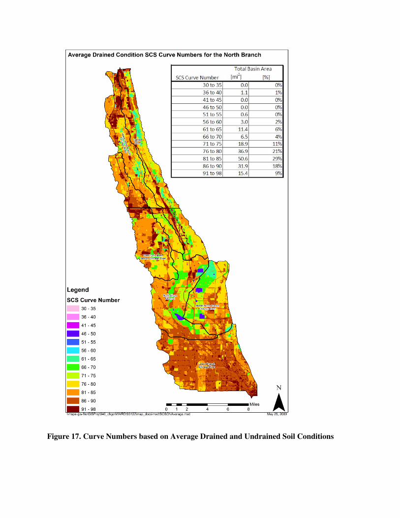
Figure 17. Curve Numbers based on Average Drained and Undrained Soil Conditions

T E C H N I C A L M E M O R A N D U M
Calumet-Sag Watershed SCS Curve Number Generation PREPARED FOR: Jonathan Grabowy \ MWRDGC
PREPARED BY: Mason Throneburg \ CH2M HILL
DATE: August 14, 2007
SCS hydrology uses the empirical curve number (CN) parameter as a part of calculating runoff volumes based on landscape characteristics such as soil type, land cover, imperviousness, and land-use development. Areas characterized by saturated or poorly infiltrating soils, or impervious development, have higher CN values, converting a greater portion of rainfall volume into runoff. The principle data sources used to develop CN values for the Calumet-Sag watershed are the Natural Resource Conversation Service (NRCS) soil data for Cook County and the 2001 Northeast Illinois Planning Commission (NIPC) land-use mapping for Cook County. This technical memorandum documents the procedure used to develop a CN grid for use in hydrologic modeling for the Calumet-Sag watershed and the assumptions inherent in this procedure.
Approach CN values are dependent on a number of factors, including the soil infiltration characteristics and condition, as well as land cover characteristics such as directly connected impervious area and cover type. Therefore both soil data and land-use data are required to estimate CN. The best available soil and land-use data for Cook County are the NRCS soil data and NIPC land-use data. Table 1 lists curve numbers based on combinations of land-use data and soil data for small urban watersheds.
TM_6_SCS_CN_DEVELOPMENT.DOC 1 COPYRIGHT 2008 BY CH2M HILL, INC. • COMPANY CONFIDENTIAL

CALUMET-SAG WATERSHED SCS CURVE NUMBER GENERATION
Table A.1 Curve Number Generation for Small Urban Watersheds
Table excerpted from Technical Release 55, Urban Hydrology for Small Watersheds, June 1986
A slightly modified version of this table will be used for curve number generation in the Calumet-Sag watershed, shown in table A.2. Both the NRCS soil data and the land use data require preprocessing before generating curve numbers using the lookup table.
TM_6_SCS_CN_DEVELOPMENT.DOC 2 COPYRIGHT 2008 BY CH2M HILL, INC. • COMPANY CONFIDENTIAL

CALUMET-SAG WATERSHED SCS CURVE NUMBER GENERATION
Table A.2 Modified Curve Number Generation for Calumet-sag Watershed.
Curve Number by Hydrologic Soil Group
Description Average % Impervious A B C D Typical Land Uses
Residential (High Density) 65 77 85 90 92 Multi-family, Apartments, Condos, Trailer Parks
Residential (Med. Density) 30 57 72 81 86 Single-Family, Lot Size ¼ to 1 acre
Residential (Low Density) 15 48 66 78 83 Single-Family, Lot Size 1 acre and Greater
Commercial 85 89 92 94 95 Strip Commercial, Shopping Ctrs, Convenience Stores
Industrial 72 81 88 91 93 Light Industrial, Schools, Prisons, Treatment Plants
Disturbed/Transitional 5 76 85 89 91 Gravel Parking, Quarries, Land Under Development
Agricultural 5 67 77 83 87 Cultivated Land, Row crops, Broadcast Legumes
Open Land – Good 5 39 61 74 80
Parks, Golf Courses, Greenways, Grazed Pasture
Meadow 5 30 58 71 78 Hay Fields, Tall Grass, Ungrazed Pasture
Woods (Thick Cover) 5 30 55 70 77 Forest Litter and Brush adequately cover soil
Woods (Thin Cover) 5 43 65 76 82 Light Woods, Woods-Grass combination, Tree Farms
Impervious 95 98 98 98 98 Paved Parking, Shopping Malls, Major Roadways
Water 100 100 100 100 100 Water Bodies, Lakes, Ponds, Wetlands
Data from http://gis2.esri.com/library/userconf/proc00/professional/papers/PAP657/p657.htm
Data is for average antecedent moisture condition II- dormant season (5-day) rainfall averaging from 0.5 to 1.1 inches and growing season rainfall from 1.4 to 2.1 inches
NRCS Soil data Soil mapping for Cook County was downloaded from the NRCS website at http://www.ncgc.nrcs.usda.gov/products/datasets/ssurgo/, representing 2002 conditions. The data downloaded includes a GIS shapefile of the soil groups and numerous text files that can be imported into an Access database and linked to the GIS data via a field called ‘Mapunit Key.’ The data field most relevant for SCS hydrology is the ‘Hydrologic Group.’ The hydrologic soil group (HSG) indicates the minimum infiltration of a specific soil group following wetting, and represented by four soil groups, shown in Table A.3.
TM_6_SCS_CN_DEVELOPMENT.DOC 3 COPYRIGHT 2008 BY CH2M HILL, INC. • COMPANY CONFIDENTIAL

CALUMET-SAG WATERSHED SCS CURVE NUMBER GENERATION
TM_6_SCS_CN_DEVELOPMENT.DOC 4 COPYRIGHT 2008 BY CH2M HILL, INC. • COMPANY CONFIDENTIAL
TABLE A.3. HYDROLOGIC SOIL GROUPS Hydrologic Soil Group Description Texture Infiltration
Rates (in/hr)
A Low runoff potential and high infiltration rates even when wetted
Sand, loamy sand, or sandy loam
> 0.30
B Moderate infiltration rates when wetted
Silt loam or loam 0.15 – 0.30
C Low infiltration rates when wetted
Sandy clay loam 0.05 – 0.15
D High runoff potential and very low infiltration when wetted
Clay loam, silty clay loam, sandy clay, silty clay, or clay
clay, or clay
0 – 0.05
All data from Technical Release 55, Urban Hydrology for Small Watersheds, June 1986
Soil groups with drainage characteristics impacted by a high water table are indicated with a ‘/D’ designation, where the letter preceding the slash indicates the hydrologic group of the soil under drained conditions. Thus an ‘A/D’ indicates that the soil has characteristics of the A soil group if drained, but the D soil group if not drained. ‘A/D’, ‘B/D’, or ‘C/D’, occur throughout the Calumet-Sag study area and represent a cumulative area of 9.11 mi^2 of the 152 square-mile watershed. Due to the difficulty of establishing the extent of drainage of these soils for each mapped soil polygon, it was assumed that 50% (by area) of these soil types were drained.
The City of Chicago is not mapped within the NRCS data set and thus does not have an assigned HSG. Based on previous studies, a minimum infiltration rate of 0.1 in/hr is reasonable in much of Chicago which corresponds to a ‘C’ HSG. In addition, a number of other soil features lacked HSG data, however these were generally open water or unmapped areas, for which CN values would not be stratified by HSG. When intersected with land-use data, the CN values are averaged across A, B , C and D values for the specified land-use type to estimate CN.
NIPC Land Use Data NIPC land-use data contains delineation of land-use categories at an average scale of 0.10 acres for features in the Calumet-Sag watershed. To generate CN values, these land-use categories must be converted to analogous land-use categories for which CN data has previously been developed. Table A.4 demonstrates the field mapping used to convert NIPC land-use categories into categories for which CN data exists.

Table A.4. NIPC field mapping to land use field.
NIPC Code NIPC Land USE SCS Land Use A B C D A/D B/D C/D NULL
1110 1110 RES/SF Residential (High Density) 77 85 90 92 84.5 88.5 91 86
1120 1120 RES/FARM Residential (Low Density) 48 66 78 83 65.5 74.5 80.5 68.75
1130 1130 RES/MF Residential (Med. Density) 57 72 81 86 71.5 79 83.5 74
1140 1140 RES/MOBILE HM Residential (High Density) 77 85 90 92 84.5 88.5 91 86
1211 1211 MALL Commercial 89 92 94 95 92 93.5 94.5 92.5 1212 1212 RETAIL CNTR Commercial 89 92 94 95 92 93.5 94.5 92.5 1221 1221 OFFICE CMPS Commercial 89 92 94 95 92 93.5 94.5 92.5 1222 1222 SINGL OFFICE Commercial 89 92 94 95 92 93.5 94.5 92.5 1223 1223 BUS. PARK Commercial 89 92 94 95 92 93.5 94.5 92.5 1231 1231 URB MX W/PRKNG Commercial 89 92 94 95 92 93.5 94.5 92.5
1232 1232 URB MX NO PRKNG Industrial 81 88 91 93 87 90.5 92 88.25
1240 1240 CULT/ENT Commercial 89 92 94 95 92 93.5 94.5 92.5 1250 1250 HOTEL/MOTEL Commercial 89 92 94 95 92 93.5 94.5 92.5 1310 1310 MEDICAL Industrial 81 88 91 93 87 90.5 92 88.25 1320 1320 EDUCATION Industrial 81 88 91 93 87 90.5 92 88.25 1330 1330 GOVT Commercial 89 92 94 95 92 93.5 94.5 92.5 1340 1340 PRISON Industrial 81 88 91 93 87 90.5 92 88.25 1350 1350 RELIGOUS Commercial 89 92 94 95 92 93.5 94.5 92.5 1360 1360 CEMETERY Open Land – Good 39 61 74 80 59.5 70.5 77 63.5
1370 1370 INST/OTHER Residential (Low Density) 48 66 78 83 65.5 74.5 80.5 68.75
1410 1410 MINERAL EXT Disturbed/Transitional 76 85 89 91 83.5 88 90 85.25 1420 1420 MANUF/PROC Industrial 81 88 91 93 87 90.5 92 88.25
1430 1430 WAREH/DIST/WHOL Industrial 81 88 91 93 87 90.5 92 88.25
1440 1440 INDUST PK Industrial 81 88 91 93 87 90.5 92 88.25
TM_6_SCS_CN_DEVELOPMENT.DOC 5 COPYRIGHT 2008 BY CH2M HILL, INC. • COMPANY CONFIDENTIAL

CALUMET-SAG WATERSHED SCS CURVE NUMBER GENERATION
TM_6_SCS_CN_DEVELOPMENT.DOC 6 COPYRIGHT 2008 BY CH2M HILL, INC. • COMPANY CONFIDENTIAL
NIPC Code NIPC Land USE SCS Land Use A B C D A/D B/D C/D NULL
1511 1511 INTERSTATE/TOLL 75 % Impervious/25 % Open Land 83.25 88.75 92.00 93.50 88.38 91.13 92.75 89.38
1512 1512 OTHER ROADWY 75 % Impervious/25 % Open Land 83.25 88.75 92.00 93.50 88.38 91.13 92.75 89.38
1520 1520 OTH LINEAR TRAN I75 % Impervious/25 % Open Land 83.25 88.75 92.00 93.50 88.38 91.13 92.75 89.38
1530 1530 AIR TRANSPORT 50 % Impervious/ 50% Open Lands 68.50 79.50 86.00 89.00 78.75 84.25 87.50 80.75
1540 1540 INDEP AUTO PRK Commercial 89 92 94 95 92 93.5 94.5 92.5 1550 1550 COMMUNICATION Agricultural 67 77 83 87 77 82 85 78.5 1560 1560 UTILITIES/WASTE Disturbed/Transitional 76 85 89 91 83.5 88 90 85.25
2100 2100 CROP/GRAIN/GRAZ Agricultural 67 77 83 87 77 82 85 78.5
2200 2200 NRSRY/GRNHS/ORC Agricultural 67 77 83 87 77 82 85 78.5
2300 2300 AG/OTHER Agricultural 67 77 83 87 77 82 85 78.5 3100 3100 OPENSP REC Open Land – Good 39 61 74 80 59.5 70.5 77 63.5 3200 3200 GOLF COURSE Open Land – Good 39 61 74 80 59.5 70.5 77 63.5 3300 3300 OPENSP CONS Open Land – Good 39 61 74 80 59.5 70.5 77 63.5 3400 3400 OPENSP PRIVATE Open Land – Good 39 61 74 80 59.5 70.5 77 63.5 3500 3500 OPENSP LINEAR Open Land – Good 39 61 74 80 59.5 70.5 77 63.5 3600 3600 OPENSP OTHER Open Land – Good 39 61 74 80 59.5 70.5 77 63.5 4110 4110 VAC FOR/GRASS Open Land – Good 39 61 74 80 59.5 70.5 77 63.5 4120 4120 WETLAND Meadow 30 58 71 78 54 68 74.5 59.25 4210 4210 CONST RES Disturbed/Transitional 76 85 89 91 83.5 88 90 85.25 4220 4220 CONST NONRES Disturbed/Transitional 76 85 89 91 83.5 88 90 85.25 4300 4300 OTHER VACANT Open Land – Good 39 61 74 80 59.5 70.5 77 63.5 5100 5100 RIVERS/CANALS Water 100 100 100 100 100 100 100 100
5200 5200 LAKE/RES/LAGOON Water 100 100 100 100 100 100 100 100
5300 5300 LAKE MICHIGAN Water 100 100 100 100 100 100 100 100 9999 9999 OUT OF REGION Water 100 100 100 100 100 100 100 100
Note: not all NIPC land use types exist within the Calumet-Sag watershed.

Steps for Generating Curve Number Grid Following the preparation of the land-use and soil data is described in the preceding two sections, three steps are followed to generate the CN Grid
1) Perform an intersection of the NRCS soil mapping polygon feature class with the NIPC land use polygon feature class. This produces a polygon feature class that has both land-use type and HSG. This feature class was output into a personal geodatabase so that Access queries could be performed on it.
2) Add a field called CurveNumber to the intersected feature class
3) Assign a CN value to each intersected polygon feature based upon HSG and land use. This was performed using an Access update query on the CurveNumber field. The soil groups impacted by high water table (e.g. ‘A/D’) were estimated to be 50% drained, using the average of the D CN and the drained (e.g. A) CN.
4) Use the “feature to raster” function in ArcToolbox to create a CN grid based on the CurveNumber value at the center of each grid pixel. A 20 ft x 20 ft grid, the same resolution as digital terrain model uses for watershed delineation, was used for this purpose.
The included figure shows the final CN grid for the Calumet-Sag watershed.
TM_6_SCS_CN_DEVELOPMENT.DOC 7 COPYRIGHT 2008 BY CH2M HILL, INC. • COMPANY CONFIDENTIAL