Embed Size (px)
Citation preview
North Meets NorthNavigation and the Future of the Arctic

Report of a working group of the Ministry for Foreign AffairsCover picture shows part of one of the Gotland Pictures from 8th century
Design: Pjaxi ltdIceland, July 2006
Translated from the Icelandic original, entitled "Fyrir stafni haf".Issued 1 February 2005
4
Contents
Introduction 5
The Northern Sea Route – From the North Atlantic to the Pacific 8 The History of Sailing in the Arctic Ocean 10 Sailing the Northern Sea Route 10 The Arctic Ocean 11 Sailing Routes Across the Arctic Ocean 13 Outlook 13 Russian Regulations Regarding the Northern Sea Route 15
Weather, Sea ice and Climate Change in the Arctic Ocean 16 Climate 16 Sea Ice 16 Climate Change 17 Melting Sea ice in the Arctic Ocean 18 The Opening of Shipping Routes 19
Shipping Between the North Atlantic and the Pacific 20 The Role of Shipping 20 Southern Routes Between the Pacific and the North Atlantic 21 The Suez Canal 21 The Panama Canal 22 The Northern Sea Route as a Shipping Route 23 Distances of Major Sailing Routes 24 Sailing Routes and the Size of Ships 26 Volume of Shipments Between Asia and the West 27 The Future of Container Shipments 28 Sailing in Ice 29
Central Transhipment Ports 32 The Increasing Importance of Transhipment Ports 32 Transhipment in the North Atlantic 33 Location of Transhipment Ports 34 The Size of Transhipment Ports 36 New Transhipment Ports in Northern Europe 37 Port Conditions in Iceland 39
Would a Transhipment Port in Iceland be Competitive? 41
Environmental Impacts of Shipping 42 Atmospheric Pollution 42 Marine Pollution 43 Environmental Accidents 44 Oil Shipments and Oil Spillage 46 Preparedness for Environmental Emergencies 47 Nuclear-powered Ships and Shipment of Nuclear Material 47
The Environmental Effects of a Transhipment Port in Iceland 49 The Environmental Effects of Port Construction 49 The Environmental Effects of Transhipment Port Operations 50 Marine Pollution and Disturbance of the Seabed 50 Atmospheric, Noise and Visual Pollution 51 Preventive Measures Regarding Environmental Impacts 51 Environmental Legislation 52Conclusion 54Epilogue 57Annex 59References 61Other Sources 62Other Sources 62

5
Introduction Navigare necesse,Vivere non necesse
A Roman proverb
"If you wish to know what men seek in this land, or why men journey thither in so great
danger to their lives, then it is the treefold nature of man which draws him thither. One
part of him is emulation and desire of fame.... Another part is the desire of knowledge....
The third part is the desire of gain...."
-From the King's Mirror, an Old Norse manuscript, circa 1250
"There is no boundary beyond which productive enterprise cannot go till North
meets North on the opposite shores of the Arctic Ocean..."
-Icelandic Canadian explorer Vilhjálmur Stefánsson
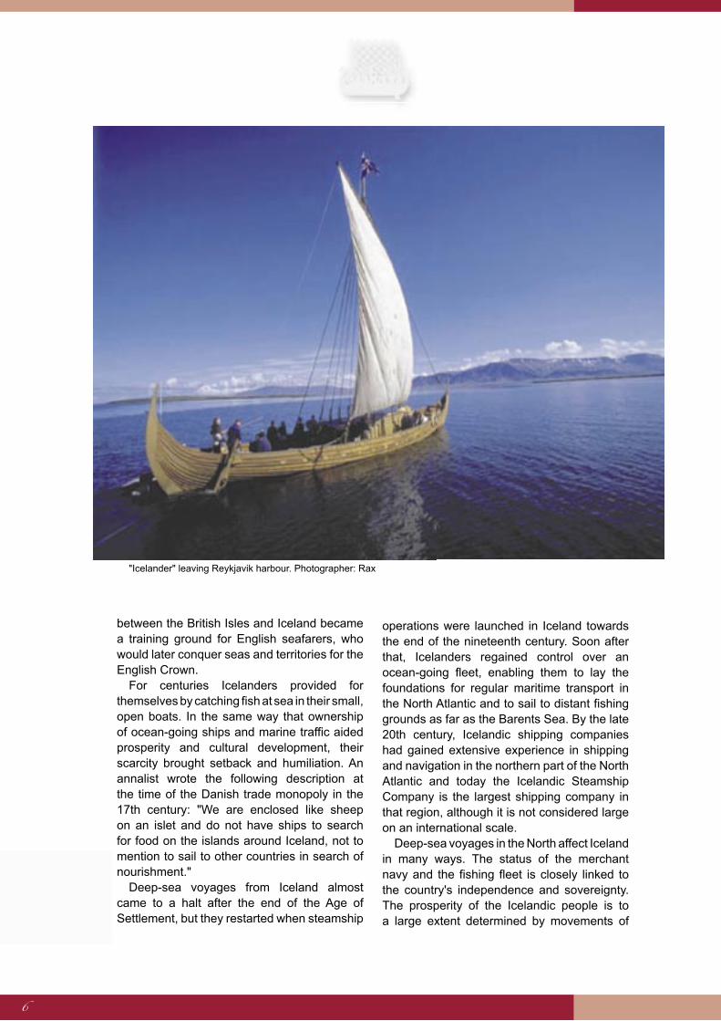
Deep-sea voyages and dealings with other nations have shaped the destiny of the people of Iceland since the first men arrived on the shores of this island in the North Atlantic Ocean.
More advanced ships and new developments in the art of sailing contributed greatly to the settlement of Iceland in the ninth century. The Vikings cruised the North Atlantic seeking fame and fortune. Icelanders established settlements in Greenland and explored the coastline of North America. They also took part in voyages heading east and, for a time, their ships made regular passage to and from the regions around the White Sea, then known as the "Land of Brightness". Apart from the Sagas, the deep-sea voyages of Icelanders were undoubtedly the greatest achievement of the Nordic people during the Middle Ages.
The Settlement of Iceland cleared the way for the first periodic transoceanic voyages known to man. These voyages were of great importance to the Norwegian monarchs, who during the Middle Ages ruled the North Atlantic,
describing it as Mare Nostrum – "Our Ocean". Icelanders relied on deep-sea voyages for their very survival. Towards the end of the twelfth century their fleet of sea-going ships had mostly vanished. Their financial and political independence was threatened, and by accepting the Gissur Covenant in 1262, they acquiesced to the rule of the King of Norway and agreed to pay taxes to him. The Covenant contained provisions for the regular arrival of merchant vessels in Iceland.
With increasing frequency the ships failed to arrive and the voyages inevitably came to a halt in the 15th century. At about the same time, however, the Europeans witnessed a technical revolution in deep-sea sailing that led to much more frequent voyages to and from Iceland. Two and three-masted vessels carrying a large spread of sail replaced the single-masted vessels of the Vikings. Offshore voyages made both by the English and the Northern German merchants of the Hanseatic League saved the Icelanders from isolation. Some historians maintain that the waters
From Jónsbók
6
between the British Isles and Iceland became a training ground for English seafarers, who would later conquer seas and territories for the English Crown.
For centuries Icelanders provided for themselves by catching fish at sea in their small, open boats. In the same way that ownership of ocean-going ships and marine traffic aided prosperity and cultural development, their scarcity brought setback and humiliation. An annalist wrote the following description at the time of the Danish trade monopoly in the 17th century: "We are enclosed like sheep on an islet and do not have ships to search for food on the islands around Iceland, not to mention to sail to other countries in search of nourishment."
Deep-sea voyages from Iceland almost came to a halt after the end of the Age of Settlement, but they restarted when steamship
operations were launched in Iceland towards the end of the nineteenth century. Soon after that, Icelanders regained control over an ocean-going fleet, enabling them to lay the foundations for regular maritime transport in the North Atlantic and to sail to distant fishing grounds as far as the Barents Sea. By the late 20th century, Icelandic shipping companies had gained extensive experience in shipping and navigation in the northern part of the North Atlantic and today the Icelandic Steamship Company is the largest shipping company in that region, although it is not considered large on an international scale.
Deep-sea voyages in the North affect Iceland in many ways. The status of the merchant navy and the fishing fleet is closely linked to the country's independence and sovereignty. The prosperity of the Icelandic people is to a large extent determined by movements of
"Icelander" leaving Reykjavik harbour. Photographer: Rax

7
goods to and from the country. Exploitation of natural resources in the northerly waters, including fisheries, is of vital importance for the national economy. Ultimately, extraction of hydrocarbons and exploitation of resources of the seabed could directly influence Icelandic concerns. Rapidly increasing maritime transport off the coast of Iceland could also have profound impacts and assign Iceland a new role within the service provision sector, e.g. in the field of transhipment in Icelandic ports. It would probably not be the first time that Iceland fulfils a role as a hub of commerce and transhipment on a long maritime route – scholars have argued that expensive and popular products from Greenland had, to a large extent, been transported via Iceland, in particular through the Gulf of Breiðafjörður, in the 11th, 12th and 13th centuries.
Maritime routes in the North also have implications for Iceland's security and defence interests. For the duration of the Cold War, Iceland played a special role in maintaining security and defence in the North Atlantic. The facilities provided by the Government of Iceland for the Member States of NATO were considered vital for the defence of the transatlantic lines of communication. Even though that state of affairs has changed and cooperation has succeeded military confrontation in the North, Iceland still holds a strategic position in securing and defending the region; an element that will become even more important assuming that new international maritime routes will pass Iceland, as circumstances almost entirely suggest.
* * *
Present-day Icelanders have for some time given thought to opportunities arising from the opening of new maritime routes. The City of Reykjavik for example, sponsored a conference on the Arctic Ocean route in October 1987 in association with, inter alia, professionals, representatives of Icelandic and foreign shipping companies, the Ministry for Foreign Affairs of Iceland and the embassies of The United States of America and The Union of Soviet Socialist Republics. One of the topics was the relevance that the predicted increase in
frequency of seagoing traffic in the Arctic Ocean could have for Iceland as a consequence of advances in maritime technology, the building of icebreakers, remote-sensing and mapping of sea ice, and information technology. By sheer coincidence, Mr. Gorbachev, then the leader of the Soviet Union, gave a speech in Murmansk in the same week heralding new attitudes in cooperation in affairs of the North and expressing the Soviet Union's interest in advancing international maritime cooperation concerning transport between the North Atlantic and the Pacific.
There is every indication that changes are likely to take place in the North in the future as a result of rapidly growing demand for natural resources and export of oil and gas from the Arctic regions of Russia surrounding the Arctic Ocean, coupled with improved conditions for navigation due to a change of climate in the area. In view of the great interests at stake for Iceland, the Minister for Foreign Affairs established a working group, under the auspices of the Ministry for Foreign Affairs, to examine the opening of the Northern Sea Route and its significance for Iceland. The working group has submitted its report and thereby fulfilled its task.
Arctic Sea Ice. Photographer: Dr. Thor Jakobsson

8
For centuries, explorers have dreamed of finding new northerly sailing routes to distant continents. A
substantial increase in shipping on the inner Northern Sea Route is expected in the next few years as a
result of oil exports and economic development along the Siberian coast. There is much at stake
for Europe and North America – an increase in exports of oil from Russia would reduce reliance on the Middle East and Central Asia for oil supplies. A
shipping route across the Arctic Ocean between the North Atlantic and the Pacific will probably open for
ice-class merchant vessels in the future, bringing considerable changes to routes in the Northern hemisphere. Satellite data concerning ice floes
and cracks in the ice and other advanced maritime technologies could contribute to the opening of the
route for international shipping earlier than predicted. However, governments must first settle national
differences relating to the right of navigation and the application of international law in the region.
The Northern Sea Route – From the North Atlantic to the Pacific
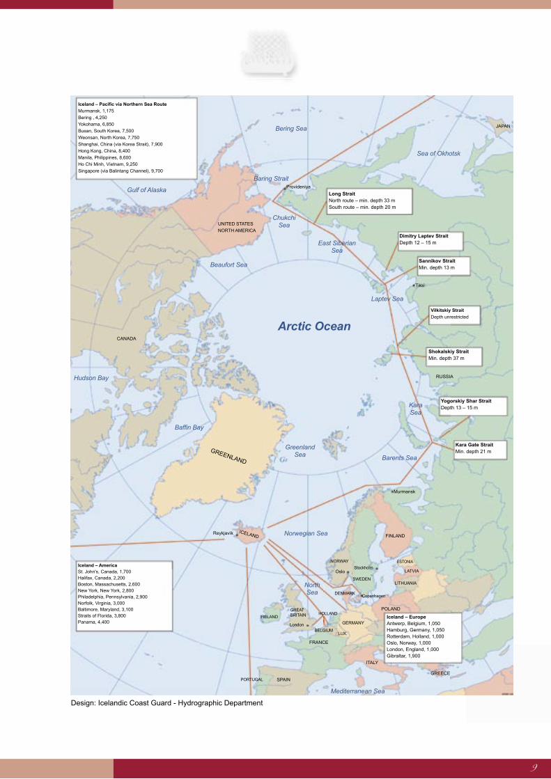
The inner passage through the Arctic Ocean winds its way along the Siberian coast, passing through channels between the mainland and offshore islands. This route is often ice-free during summer months. Merchant vessels and sailboats have occasionally completed the entire passage in autumn without the assistance of ice-breakers. However, shallow channels and impassable winter ice make the route unsuitable for large freighters and tankers. Those vessels would benefit from an offshore route through deeper waters.channels and impassable winter ice make the route unsuitable for large freighters and tankers. Those vessels would
9
Design: Icelandic Coast Guard - Hydrographic Department
ICELAND
GREENLAND
Reykjavík
Iceland – Pacific via Northern Sea Route
Murmansk, 1,175
Bering , 4,250
Yokohama, 6,850
Busan, South Korea, 7,500
Weonsan, North Korea, 7,750
Shanghai, China (via Korea Strait), 7,900
Hong Kong, China, 8,400
Manila, Philippines, 8,600
Ho Chi Minh, Víetnam, 9,250
Singapore (via Balintang Channel), 9,700
Long Strait North route – min. depth 33 m South route – min. depth 20 m
Dimitry Laptev Strait Depth 12 – 15 m
Sannikov Strait Min. depth 13 m
Vilkitskiy Strait
Depth unrestricted
Shokalskiy Strait Min. depth 37 m
Yogorskiy Shar Strait Depth 13 – 15 m
Kara Gate Strait Min. depth 21 m
Iceland – Europe Antwerp, Belgium, 1,050 Hamburg, Germany, 1,050 Rotterdam, Holland, 1,000 Oslo, Norway, 1,000 London, England, 1,000 Gibraltar, 1,900
Iceland – America St. John's, Canada, 1,700 Halifax, Canada, 2,200 Boston, Massachusetts, 2,600 New York, New York, 2,800 Philadelphia, Pennsylvania, 2,900 Norfolk, Virginia, 3,000 Baltimore, Maryland, 3,100 Straits of Florida, 3,800 Panama, 4,400
Gulf of Alaska
RUSSIA
Murmansk
FINLAND
ESTONIA
LATVIA
LITHUANIA
POLAND
ITALY
GREECE SPAIN PORTUGAL
FRANCE
BELGIUM
GERMANY
GREAT BRITAIN IRELAND
LUX.
NORWAY
Oslo
London
SWEDEN
Stockholm
DENMARK Copenhagen
HOLLAND
UNITED STATES
NORTH AMERICA
CANADA
Tiksi
Provideniya
Chukchi Sea
East Siberian Sea
Beaufort Sea
Arctic Ocean
Kara Sea
Laptev Sea
Barents Sea
Norwegian Sea
North Sea
Hudson Bay
Baffin Bay
Mediterranean Sea
Greenland Sea
Baring Strait
Bering Sea
Sea of Okhotsk
JAPAN
10
The History of Sailing in the Arctic Ocean
For most of history, the world has looked on the Arctic as a cold and forbidding region. Travel in extreme northern latitudes was rare until the charting of the region suggested to Europeans that a shorter route to Asia might exist in the North. British and Dutch expeditions probed for new sailing routes in the middle of the 15th century, looking for a way to reach India and China. At the end of the 15th century, John Cabot led an expedition to find a route to the Pacific to the north of Canada, but he turned back after meeting impassable ice.
The Russians continued to explore the eastern part of the Arctic Ocean during the 17th and 18th centuries and the Canadians started to search for a western passage in the 19th century. Interest in the Arctic region dwindled as stories of the hardship endured by early explorers spread, along with tales of intensely cold weather. The tragic demise of the Franklin Expedition in 1848 brought exploration in the Northwest Arctic to a complete stop for several decades.
However, expeditions continued to search for a passage through the East Arctic region and Nils A. E. Nordenskjöld, from Sweden, became the first person to sail the Northeast Passage, as it was then known, all the way to the Pacific Ocean.
Vilhjálmur Stefánsson, from Iceland, travelled widely in the Arctic at the start of the 20th century and his books helped to change the image of the North and reawaken interest in the region. At the same time, technical advances and the introduction of ice-breakers greatly improved sailing conditions in the far north. The Northern Sea Route became an essential part of Siberia's transport system during the 1940s. It provided an important new option for the transport of goods in Arctic Russia and for the export of nickel and other minerals from West Russia, although the resulting income fell far short of the cost of keeping the route open.
The strategic importance of the Arctic region during the Cold War led to substantial investment in military installations, ports and communications. The North Pole area became a potential battlefield and submarines armed with nuclear weapons were stationed under the
ice-sheet. Surface shipping in the region was limited to the Soviet fleet, which commissioned powerful nuclear powered ice-breakers to keep the route open at all costs. Freight transport in Soviet waters increased dramatically during the period 1953 to 1987, rising from 500,000 tons to over 6,500,000 tons.
Sailing the Northern Sea Route
The end of the Cold War brought a significant change in the conditions that affect the Northern Sea Route.
First signs of a shift in Russia's stance regarding the Arctic region surfaced in 1987 when Gorbachev, last leader of the Soviet Union, announced in Murmansk that the passage would be open to foreign ships with the assistance of Soviet ice-breakers. He said, "Let the North Pole and the Arctic become a region of peace."
However, it wasn't until 1991 that the Russians formally opened the Northern Sea Route for foreign shipping and issued regulations covering maritime activities in the region. Russia was hopeful that the passage would become a regular international sailing route, believing that the accompanying ice-breakers and other shipping services would generate enough income to meet the cost of keeping the route open. Those targets remain to be achieved.
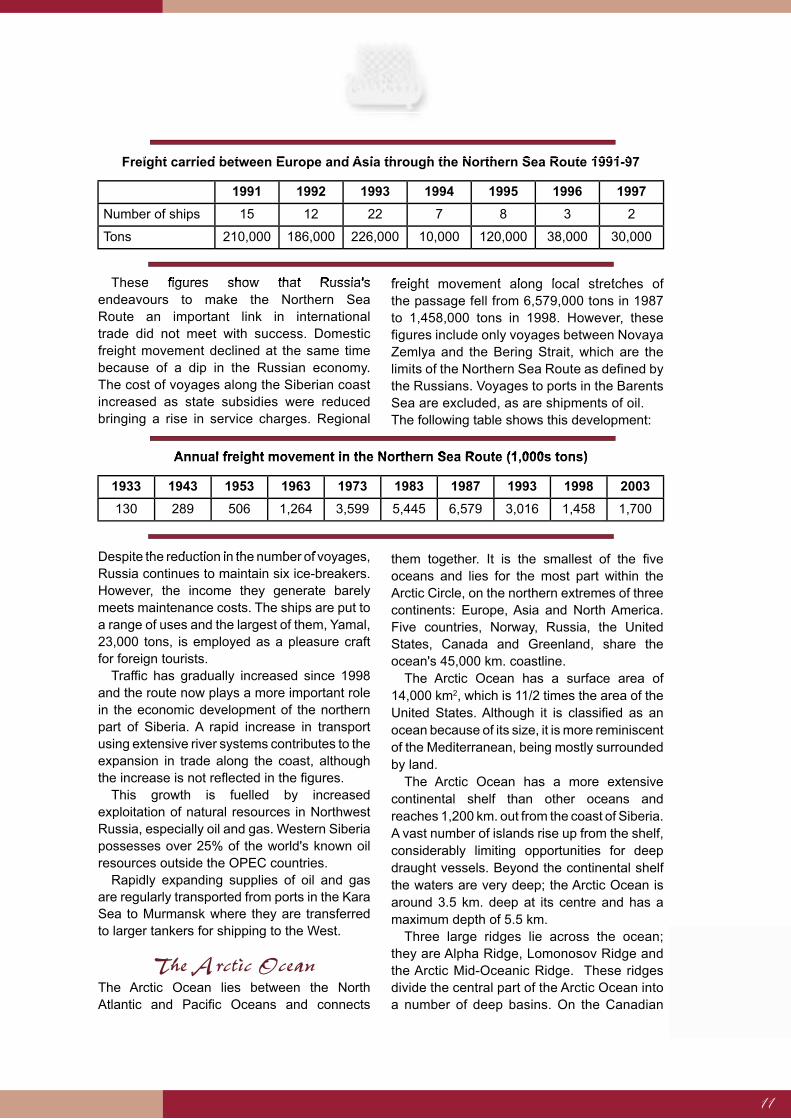
During the summer in which the regulations were issued, 15 ships sailed between East Asia and Europe using the Northern Sea Route, transporting a total of 210,000 tons of cargo. Voyages reached a peak of 22 vessels carrying 226,000 tons in 1993, after which numbers declined because of the precarious nature of the trips and the high charges levied for accompanying ice-breakers and other services. High insurance premiums also discouraged foreign shipping companies from using the route. In 1997 only two ships sailed the entire passage with just 30,000 tons of freight, as can be seen in the following table. Cargoes consisted mainly of fertilisers, metal and timber exported from Finland and Sweden to Japan, and of processed agricultural products transported to Europe from China and Thailand.
11
These figures show that Russia's endeavours to make the Northern Sea Route an important link in international trade did not meet with success. Domestic freight movement declined at the same time because of a dip in the Russian economy. The cost of voyages along the Siberian coast increased as state subsidies were reduced bringing a rise in service charges. Regional
freight movement along local stretches of the passage fell from 6,579,000 tons in 1987 to 1,458,000 tons in 1998. However, these figures include only voyages between Novaya Zemlya and the Bering Strait, which are the limits of the Northern Sea Route as defined by the Russians. Voyages to ports in the Barents Sea are excluded, as are shipments of oil.The following table shows this development:
Despite the reduction in the number of voyages, Russia continues to maintain six ice-breakers. However, the income they generate barely meets maintenance costs. The ships are put to a range of uses and the largest of them, Yamal, 23,000 tons, is employed as a pleasure craft for foreign tourists.
Traffic has gradually increased since 1998 and the route now plays a more important role in the economic development of the northern part of Siberia. A rapid increase in transport using extensive river systems contributes to the expansion in trade along the coast, although the increase is not reflected in the figures.
This growth is fuelled by increased exploitation of natural resources in Northwest Russia, especially oil and gas. Western Siberia possesses over 25% of the world's known oil resources outside the OPEC countries.
Rapidly expanding supplies of oil and gas are regularly transported from ports in the Kara Sea to Murmansk where they are transferred to larger tankers for shipping to the West.
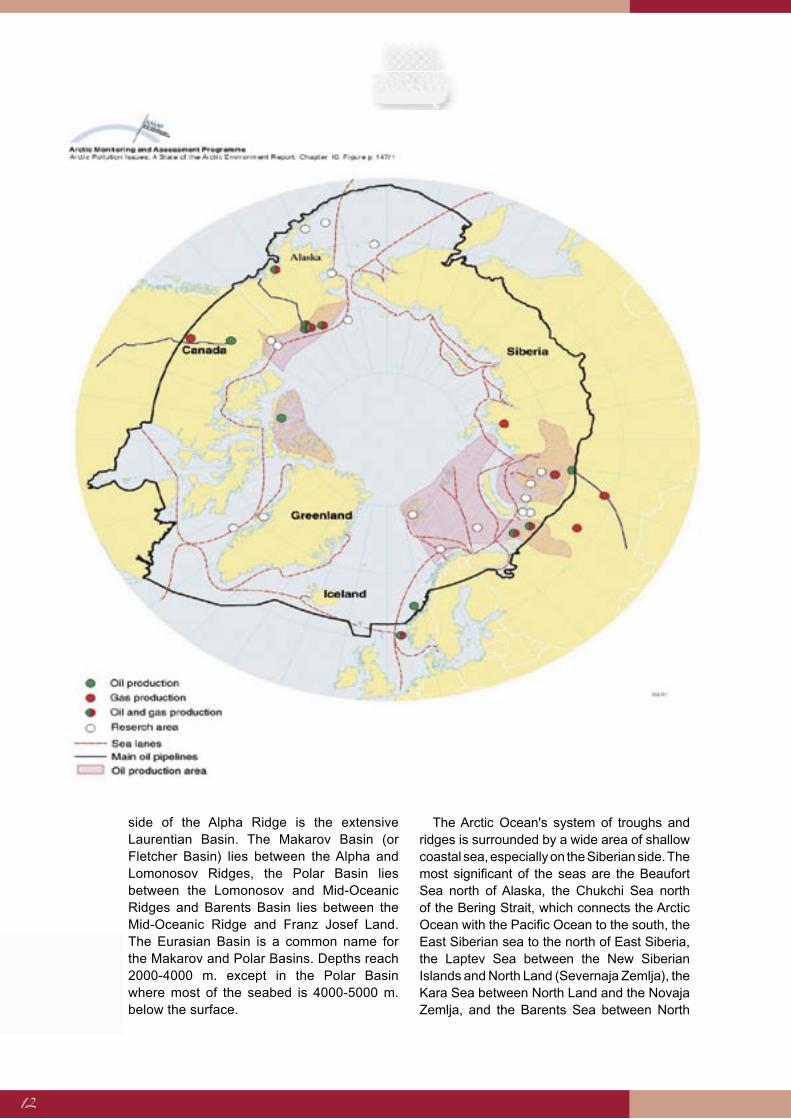
The Arctic OceanThe Arctic Ocean lies between the North Atlantic and Pacific Oceans and connects
them together. It is the smallest of the five oceans and lies for the most part within the Arctic Circle, on the northern extremes of three continents: Europe, Asia and North America. Five countries, Norway, Russia, the United States, Canada and Greenland, share the ocean's 45,000 km. coastline.
The Arctic Ocean has a surface area of 14,000 km2, which is 11/2 times the area of the United States. Although it is classified as an ocean because of its size, it is more reminiscent of the Mediterranean, being mostly surrounded by land.
The Arctic Ocean has a more extensive continental shelf than other oceans and reaches 1,200 km. out from the coast of Siberia. A vast number of islands rise up from the shelf, considerably limiting opportunities for deep draught vessels. Beyond the continental shelf the waters are very deep; the Arctic Ocean is around 3.5 km. deep at its centre and has a maximum depth of 5.5 km.
Three large ridges lie across the ocean; they are Alpha Ridge, Lomonosov Ridge and the Arctic Mid-Oceanic Ridge. These ridges divide the central part of the Arctic Ocean into a number of deep basins. On the Canadian
1991 1992 1993 1994 1995 1996 1997
Number of ships 15 12 22 7 8 3 2
Tons 210,000 186,000 226,000 10,000 120,000 38,000 30,000
Freight carried between Europe and Asia through the Northern Sea Route 1991-97Freight carried between Europe and Asia through the Northern Sea Route 1991-97
These figures show that Russia's freight movement along local stretches of
1933 1943 1953 1963 1973 1983 1987 1993 1998 2003
130 289 506 1,264 3,599 5,445 6,579 3,016 1,458 1,700
Annual freight movement in the Northern Sea Route (1,000s tons)Annual freight movement in the Northern Sea Route (1,000s tons)
Despite the reduction in the number of voyages,
12
side of the Alpha Ridge is the extensive Laurentian Basin. The Makarov Basin (or Fletcher Basin) lies between the Alpha and Lomonosov Ridges, the Polar Basin lies between the Lomonosov and Mid-Oceanic Ridges and Barents Basin lies between the Mid-Oceanic Ridge and Franz Josef Land. The Eurasian Basin is a common name for the Makarov and Polar Basins. Depths reach 2000-4000 m. except in the Polar Basin where most of the seabed is 4000-5000 m. below the surface.
The Arctic Ocean's system of troughs and ridges is surrounded by a wide area of shallow coastal sea, especially on the Siberian side. The most significant of the seas are the Beaufort Sea north of Alaska, the Chukchi Sea north of the Bering Strait, which connects the Arctic Ocean with the Pacific Ocean to the south, the East Siberian sea to the north of East Siberia, the Laptev Sea between the New Siberian Islands and North Land (Severnaja Zemlja), the Kara Sea between North Land and the Novaja Zemlja, and the Barents Sea between North
13
Norway and Franz Josefs Land, Svalbard and Novaja Zemlja. The White Sea penetrates into West Russia from the south of the Barents Sea. Seas around Canada include Baffin Bay, Hudson Bay and the Canadian gulfs.
Sailing Routes Across the Arctic Ocean
The shortest route between the North Atlantic and Pacific Oceans is the Polar Route, bisecting the Arctic Ocean in a line directly north from Iceland, over the North Pole to the Bering Strait. This route is impassable except for the most powerful ice-breakers, capable of forcing a way through the thick layer of ice in the centre of the Arctic Ocean.
The Northwest Passage runs from the Bering Strait in the west through the channels along the Alaskan and Canadian coasts, reaching the Atlantic between Labrador and Greenland. It is a difficult route. Sea ice carried by currents from the Arctic Ocean drifts into the Canadian channels where pack-ice accumulates over large areas. Specially strengthened ships have completed this passage with the help of ice-breakers. It is hoped that this route will be opened for general shipping in the future as a result of the increasing effects of global warming. However, those effects are more apparent in the East Arctic Ocean where the ice-sheet is shrinking more quickly.
The Northern Sea Route runs from the Bering Strait along the north coast of Russia to the North Atlantic, passing through the Norwegian Sea between North Norway and Greenland. There are in fact two routes: the Inner Northern Sea Route and the Outer Route.
The Inner Northern Sea Route is a coastal route much used by regional shipping and for exports from Northwest Russia. It threads its way along the continental shelf among chains of islands off Siberia, passing through five coastal seas and eight channels between Murmansk in the west, the only port in the region that is ice-free throughout the year, and Vladivostok in the east. The Russian authorities regard the Inner Northeast Sea Route as a Russian coastal route and specify its westerly limit as Novaya Zemlya. Routes in the Barents Sea are accordingly not considered to be part of the Northern Sea Route.
Global warming and summer temperatures have already brought substantial improvements to sailing conditions along this route and several ships completed the passage to the Pacific in summer 2003. Ice disrupts sailing in wintertime and shallow channels between the islands restrict a ship's maximum draught to 9 metres.
The Outer Northern Sea Route begins in the west between Novaya Zemlya and Franz Josef Land, passes north of the islands of Severnaya Zemlja (North Land), the New Siberian Islands and Vrangelya before turning into the Bering Strait, the route's eastern boundary. This route is very deep and generally enjoys good weather. Ice is a serious hazard to shipping, although less so in summer when long sections of the route are ice-free.
OutlookA substantial increase in domestic shipping on the Northern Sea Route is expected in the next few years, whether or not sailing conditions improve due to global warming, because of oil exports and economic development along the Siberian coast . Russian oil shipments along the route are growing rapidly and predictions suggest that within a few years Murmansk could well become the world's largest oil terminal.
Russia is thought to possess greater reserves of oil than any other country outside the OPEC group of nations, and its reserves of natural gas are the most extensive in the world. Production is highest in Western Siberia, while new resources are being surveyed both there and in the Barents Sea. It is also thought that there are vast resources of oil and gas in East Siberia and the surrounding continental shelf. Russia's mainland and territorial waters are expected to yield as many as 500 exploitable oil-fields although of production has yet to begin. Oil probably exists in western parts of the Arctic Ocean although work in that region is unlikely to begin for many years.
Ship movements along the East Siberian coast are expected to be stimulated by oil and gas discoveries. This could lead to the speedier development of maritime technology and equipment for use in ice affected regions, resulting in regular sailings all the way to the Pacific sooner rather than later.

14
There is much at stake for Europe and North America – an increase in exports of oil from Russia would reduce reliance on the Middle East and Central Asia for oil supplies.
Russia must first renew its fleet of ice-breakers to deal with increased traffic and at the same time improve other services, including rescue and emergency services, information services and weather and ice forecasts. Russia's satellite
network has 14 stations dedicated to the route, but this is viewed as the minimum requirement for route-finding through the ice.
It is probable that the Russians expect developments in shipping on the Northern Sea Route based on the above premises. The following table shows the upper and lower limits of potential expansion according to assessments made by Russian specialists.
The importance of oil shipments is evident. Norwegian estimates are even higher than the figures shown in the table. They show consignments at 2.5 million tons in 2003 and reaching 4.5 million tons in 2005.
The prediction of transportation totals stated above is built on information from the Northern Sea Route Administration, which bases its calculations on the ability of Russian ice-breakers to assist oil tankers in the Kara Sea. A number of oil industry experts believe that shipments of oil from the area will increase much faster, reaching 25 million tons by 2010 and as much as 100 million tons within 10 years. The oil will be shipped in tankers specially built for sailing in ice affected seas or by pipeline to the port of Murmansk, which is ice-free throughout the year.
A large proportion of the oil goes to the United States. Iceland inevitably has a part to play in connection with these shipments, lying in the middle of this important shipping route. Possible roles include monitoring shipping and reacting to unpredictable events, oil refining or the provision of oil storage facilities to service the North Atlantic tanker fleet.
The Russian predictions are based solely on domestic transport needs within the Russian Arctic region and no attempt was made to assess the likelihood traffic sailing between the North Atlantic and Pacific Oceans. It is probable that some vessels will follow the coast all the way to the Pacific as shipping on the Inner Northern Sea Route increases as a consequence of economic development in Northwest Russia. However, the inner route will not become a major shipping route for large capacity merchant ships sailing between oceans as depth limitations in the channels restrict the size of vessels that can pass though. The formation of winter ice along the coast and in coastal seas makes winter passages very difficult, even though there is little or no ice at the end of summer.
Large-scale shipments through the Arctic Ocean, between the North Atlantic and Pacific Oceans, will not begin until the Outer Northern Sea Route becomes passable for large vessels. There are indications that changes in sea ice in the Arctic Ocean due to global warming in the polar region will allow for the opening of the Northern Sea Route for ice-class merchant vessels sometime in the future. This will bring
2003 2005 2010 2015
Total shipment ,000 tons 1,700 2,340 4,890 7,810
Oil component 465 710 2,515 4,640
Minimum predicted level of shipments on the Northern Sea Route
2003 2005 2010 2015
Total shipment ,000 tons 1,700 3,575 8,620 11,380
Oil component 465 795 4,635 5,890
Maximum predicted level of shipments on the Northern Sea Route
Minimum predicted level of shipments on the Northern Sea Route
Maximum predicted level of shipments on the Northern Sea Route
15
fundamental changes to shipping routes in the Northern Hemisphere, which will be discussed in the following chapter.
Constantly updated satellite data concerning ice floes and cracks in the ice that would make route finding easier along with other advances in maritime technologies could contribute to the opening of the route for international shipping earlier than predicted.
Russian Regulations on the Northern Sea Route
Russia regards the Northern Sea Route as a Russian sailing route and claims jurisdiction as far as the North Pole based on Article 234 of the United Nations Convention on the Law of the Sea, which provides for special rights for nations with ice-bound regions within their territory.
Russia imposed regulations on sailing on the Northern Sea Route in 1991. They were for the most part in line with regulations set by other coastal nations that were intended to reduce the risk of pollution caused by ships sailing close to land. The publication of the regulations was regarded at that time as a progressive step, opening the route for international shipping and specifying security procedures.
The regulations also specify the require-ments for sailing permits issued by the Russian authorities1 These requirements include notification obligations, authorisation and charges, environmental damage liability, safety considerations in ship design and crew equipment. Foreign ships must have a Russian pilot on-board and employ the services of Russian ice-breakers in regions of ice. Additionally, the Russians reserve the right to close maritime regions, to stop and inspect ships, cancel permits due to alleged breaches of the regulations and to arrest and imprison alleged offenders. Russia also assumes jurisdiction over all ships sailing in the region including ships owned by foreign powers, public research vessels and military vessels.
Other states have reservations about particular parts of the regulations and believe they restrict the right to unhindered sailing on an international shipping route. They are
critical of the charges levied on foreign ships, the stipulation that a Russian pilot must be present and the insistence on the use of Russian ice-breakers.
Some of the regulations are ambiguous and difficult to interpret exactly. They are to some extent similar to regulations set by the Canadians regarding the Northeast Passage, which have not provoked objections from foreign ship owners. Some coastal nations with similar interests are likely to follow Russia's lead. Besides, to raise objections to regulations or laws that apply to safety and security on the route may also be questionable.
Still, it is unlikely that states with so much to gain from the opening of the Northern Sea Route will accede to Russian control so far out in the Arctic Ocean.
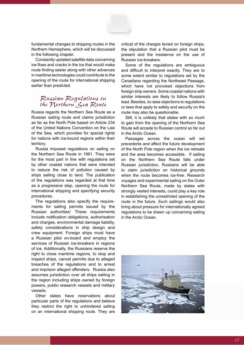
Passages across the ocean will set precedents and affect the future development of the North Pole region when the ice retreats and the area becomes accessible. If sailing on the Northern Sea Route falls under Russian jurisdiction, Russians will be able to claim jurisdiction on historical grounds when the route becomes ice-free. Research voyages and experimental sailing on the Outer Northern Sea Route, made by states with strongly vested interests, could play a key role in establishing the unrestricted opening of the route in the future. Such sailings would also bring about pressure for internationally agreed regulations to be drawn up concerning sailing in the Arctic Ocean.

16
Weather, Sea ice and Climate Change in the Arctic Ocean
A large body of research concludes that rising temperatures are causing ice to melt in the Northern Hemisphere. When the various effects of climate and weather variability and
change are introduced into computer models that project atmospheric temperature patterns, the results clearly show that the average temperature in the Arctic region could rise by
3-9°C over the next hundred years, which is double the increase expected in other parts of the world during the same period. Warming would cause an enormous quantity of ice
to melt and it is believed that ice could disappear altogether from large areas of the ocean during the summer months in the coming decades. Extensive melting has already begun, especially in areas of thick perennial ice. Computer models show that the surface area of
ice at the end of summer could contract by 15% to 40% by the year 2050, accompanied by reductions in average thickness of up to 30% in the same period. Indications are that the
Arctic Ocean could be relatively free of ice towards the end of the century. Ice will still form during wintertime but it will be a comparatively thin layer and ice-breakers will be able to force a passage through it. Ocean currents will probably cause the ice to drift away from
eastern regions of the Arctic Ocean, which would ease sailing conditions.
ClimateProlonged periods of cold and relatively small fluctuations in temperature are characteristic of the polar climate. The weather varies little from day to day and sudden changes are uncommon. An area of high pressure generally lies over the North Pole region bringing calm or gentle winds.
The most evident seasonal changes are due to the changing path of the sun, with perpetual darkness in midwinter and twenty-four hours of daylight in the summer months. During periods of winter darkness the average temperature is -20°C to -30°C, with little wind, no cloud and no precipitation. Summers are wet, when sunshine melts the ice and occasional low pressure systems cross the region bringing precipitation and fog.
These conditions are not expected to change to any great degree, although winds might become more common as increasing interaction between air and water vapour causes a rise in atmospheric movement. The most obvious change to weather patterns in northern climes will be a shift of a few degrees to the north of the low pressure belt that currently lies over Iceland. Cyclonic effects could reach further north with accompanying increases in wind and rain or snow.
Sea IceThe Arctic Ocean is mostly covered in ice, over an area that varies according to the season and the precise region. Ocean currents also cause variations in the density of the ice layer. Computer models show how the ice is distributed and projections similar to weather forecasts can assist in passage-making in icebound regions.
There are three main types of sea ice. New ice is freshly formed, no more then a few months old and rarely more than 30 cm thick. Annual ice is 1-2 years old and can be from 30 cm up to two metres thick. Perennial ice is two or more years old. It can be over two metres thick. As ice grows older it becomes thicker and its density increases, offering more resistance to ships sailing through.
The North Polar climate and ocean currents cause the centre of the Arctic Ocean to be almost constantly covered in ice. The ice is mostly perennial with a thickness of between two and three metres. Pressure ridges occur where ice-sheets meet and are up to three times thicker, generally six to eight metres. They are of mixed density depending on the condition and age of the ice.
Average of five computer models showing projected changes in the distribution of polar

17
sea ice at the end of summer according to a report produced by the Arctic Council on the effects of climate change on the Arctic region (Arctic Climate Impact Assessment – ACIA) published in 2004.
Changes in the annual distribution of sea ice are considerable. Greatest coverage occurs at the end of winter. The ice generally reaches its maximum extent at the end of May when it begins to melt. It rapidly shrinks during the summer when the much smaller ice sheets are often surrounded by open sea; large areas of sea around the periphery of the Arctic Ocean are ice-free at the end of summer.
The ice sheets break up off the north coast of Russia where the most important routes pass. The last few years have also seen large holes and ice-free areas form in the Arctic Ocean; wide channels have also appeared that are navigable for shipping. The minimum extent of the ice sheets occurs at the end of September when there are large numbers of icebergs. New ice begins to form in October and the ice sheets begin to expand again, reaching land all around the region in springtime.
The thickest perennial ice is stretches mostly from the north of Canada all the way to the North Pole. It enters a cyclical system in the west Arctic (Canadian side) where a small portion drifts south into the Greenland Sea between Greenland and Svalbard then further south along the Greenland coast.
The ice on the inner route, along the Siberian coast, is mainly annual ice and it mostly disappears by the end of summer, leaving a large part of the route free of ice. This is highly significant for sailing in the region as oil and gas exports continue to rise rapidly.
Climate ChangeObservations in the last few years show rising temperatures and more melting ice in the Northern Hemisphere. A more detailed assessment of the effects of climate change and variability in the polar region was made at the request of the Arctic Council and a report (Arctic Climate Impact Assessment – ACIA) issued in November 2004, indicates that the average temperature at the North Pole has risen much faster in the last hundred years than at any other place on Earth, and this trend will probably continue. The assessment is based on long-term measurements that show a higher rise at the pole than in other places.
Opinions are varied as to the cause of the temperature rise, but many scientists tend to agree that atmospheric pollution and the release of carbon dioxide and other greenhouse gases since the start of the industrial revolution are the main causes. However, the effects of natural cycles in levels of solar radiation cannot be ruled out, nor can the effects of long-term fluctuations in ocean
Average of five computer models showing projected changes in the distribution of polar sea ice at the end of summer according to a report produced by the Arctic Council on the effects of climate change on the Arctic region (Arctic Climate Impact Assessment - ACIA) published in 2004.

18
currents and volcanic ash from large eruptions. Various changes that accompany atmospheric and oceanic temperature rises affect the extent and thickness of sea ice. The circulation of the atmosphere becomes disrupted, the low pressure belt moves and brings changes to wind and rain patterns while both gradual and dramatic changes affect the oceans, including the strength of the Gulf Stream.
When the effects of climate and weather changes are introduced into computer models that project atmospheric temperature patterns, the results clearly show that the average temperature in the Arctic region could rise by 3-9°C over the next hundred years, which is double the increase expected in other parts of the world during the same period.
Several interconnected reasons explain the faster rise in temperature in polar regions. The shrinking surface area of ice allows more sunlight to shine on the sea and less light is reflected. This causes the sea temperature to rise, which in turn causes even more ice to melt. The lowest layer of the atmosphere is thinner over the poles than at the equator and continuous stable weather creates good conditions for heat exchange between atmospheric layers and the sea or ice.
Melting Sea ice in the Arctic Ocean
Research shows an indisputable reduction in the extent of sea ice in the last part of the 20th century. Examination of its size during the last 40 years reveals an average reduction in area of 3% per decade. The calculations are based on detailed Arctic data gathered over many years, including information from ships, submarines, satellites and weather stations in space that use microwave technology to monitor the ice, even through cloud cover or fog.
There is evidence that the thickness of the ice is diminishing more quickly than was thought and some research suggests that the ice will be 40% thinner in just two decades. It is unlikely that this conclusion will apply to the average for the whole Arctic Ocean; it points principally to a reduced proportion of perennial ice. Scientists agree, however, that the ice is thinning quickly, meaning that the surface area will be reduced in the near future by more than the 3% per
decade that researchers have calculated for recent decades.
The rate of the reduction varies in different parts of the region. The eastern Arctic Ocean will be most affected, particularly the Kara Sea and the Barents Sea, where the annual rate of shrinkage has reached almost 10%. Ship movement in those areas has become easier and is becoming increasingly important in energy provision at a global level as the demand for oil escalates relentlessly.
However, ice has increased in other areas, notably in the western part of the Arctic along the north coast of Canada. This is probably a side-effect of the break-up of larger ice-sheets further afield into smaller ice floes that drift to the west with ocean currents. This concurs with research into changes in the ice in the coastal seas of the Arctic Ocean along the Siberian coast, which shows a varied rate of thinning and in some places a localised increase in ice.
A large number of scientists and research teams are now observing the ice, both at the North and South Poles. They are in agreement that there is a connection between rising average global temperatures and ice melting in polar regions, but there is contention about the interpretation of local data and the speed of melting.
An example from one of Iceland's neighbours is that since 2002, the southern limit of summer sea ice along the east coast of Greenland has been latitude 75°N, which is 500 km north of the average limit. This is an almost unique example, comparable only to conditions at the time of the settlement of Iceland in the 9th century when the sea was thought to have been similarly ice-free for several consecutive years. The sea freezes along all of the east coast of Greenland during wintertime; the ice is probably somewhat thinner although specific research has yet to be carried out to confirm this.
The reasons for the high level of summer melting of sea ice along the east coast of Greenland are higher sea temperatures and faster melting when the rays of the summer sun melt the ice and shine directly on the surface of the sea. Melting is fastest along the coastal band of ice.
The massive reduction in autumn sea ice in the East Greenland current is consistent with sea ice developments in the Arctic Ocean during the last few decades. Data collected from weather
19
satellites between 1978 and 2002 reveals an 8% reduction in the area of the Arctic Ocean cove-red by ice during that period. Scientists from the Fridtjof Nansen Institute in North Norway reached a similar conclusion. Their research showed a 3% reduction in the surface area of the ice in the Arctic Ocean per decade during the last two decades of the 20th century. It is interesting that the reduction in perennial ice seems to be much faster, with research indicating a 7% reduction in thick ice of this type during the same period. Scientists are of the opinion that the Arctic Ocean could be mostly ice-free around the year 2080 if developments continue at the same rate as at the end of the 20th century.
In 1999, a comparison was made of ice thickness measurements made at a range of places in the Arctic in 1958. The results confirm the decrease in the amount of sea ice2 They show that the ice became on average 1.3 m thinner over a 20 year period, dropping from 3.1 m to 1.8 m, indicating a reduction in volume of 40%. However, because measurements were taken in only a limited number of places these findings are not considered significant across the entire Arctic Ocean, although the research produced some important evidence.
Researchers found that thinning of the ice was by far the quickest in areas with much perennial ice but less in areas of thinner annual ice. Thus, they discovered considerable thinning of the ice over a large are between the centre of the Arctic Ocean and the northeast coast of Russia, where perennial ice is giving way to annual ice.
The scientific community generally agrees that indications suggest that melting will continue, although they have yet to reach agreement on the speed of these changes. A large number of computer models have been made to predict the likely course of events over the next decades based on the above data. They suggest a reduction in the area of sea ice in the Arctic Ocean of between 15% and 40% by the summer of 2050, and that it will become on average 30% thinner over the same period. This extensive melting will lead to large areas of ocean, that were once covered in ice, becoming clear for a large part of the year in the middle of this century, and the Arctic Ocean will be for the most part ice-free during the summer months at the end of this century. Winter will still bring freezing weather, but the ice that forms will be relatively thin and passable for ice-class ships.
The Opening of Shipping Routes
Ice melts more quickly in summer along the edges of the ice sheet and along coasts, where the sun heats the sea; this course of events is significant for the Northern Sea Route. The ice recedes more quickly from shipping routes off Siberia than the average for the whole Arctic Ocean. Ice in Russian waters, where the Inner Northern Sea Route passes, is expected to almost completely disappear during summertime in the first half of this century, resulting in a clear and passable shipping route well into autumn when it begins to freeze again.
The Outer Northern Sea Route, which lies along the edge of the North Pole ice cap, could also become relatively passable in summer as the Arctic ice sheets shrink. More and more ice on the Outer Route is relatively thin annual ice, although there are still large areas of perennial ice. There are comparatively few ice ridges. Modern surveying technology, showing movement and channels in the ice, makes it easier for well-equipped ships to find the easiest route and force a way through the ice.
If perennial ice disappears from the Outer Northern Sea Route within a few years, the route could soon be open throughout the year for ice-class merchant vessels with the power to break through the one metre thick annual ice sheet.
Currents in the Arctic Ocean carry the ice to the west, into the Canadian channels, where sea ice is increasing. As a result, the ice is diminishing and disintegrating in the east of the ocean, which may in turn lead to the break-up of the ice cap and to the opening of the route directly across the Arctic Ocean much earlier than has generally been forecast. The sea route from the North Atlantic to the Pacific would become even shorter, directly north from Iceland, between Greenland and Svalbard, over the North Pole and then south through the Bering Strait.
The complex interrelation of many factors makes it impossible to predict exactly when this route might open for general shipping. It is important to monitor developments constantly as there are indications that changes in sailing conditions in the Arctic Ocean could happen on short notice.
20
The Role of ShippingShipping has served as the powerhouse of economic and cultural developments for centuries. It was the lifeblood of ancient Mediterranean cultures. Christopher Columbus' voyages across the Atlantic in search of a shorter route to India at the end of the 15th century and the consequent settlement of the New World by white men shifted commercial and urban importance from the Mediterranean to Atlantic coastlines. Shipping also played a key role in the industrial revolution, allowing the export of industrial products from Europe in exchange for raw materials from other continents. Enormous numbers of ships crossed the Atlantic Ocean, giving rise to mass emigrations from Europe to America and creating conditions for faster economic growth on both sides of the North Atlantic.
The introduction of new modes of transport such as railways, motor vehicles and aeroplanes had little effect on the importance of marine transport in the last century. Shipping is still the mainspring of modern economies.
Assessments suggest that 90% of all goods in the world, measured in tons, are transported by sea. Global commerce would be inconceivable without marine transport to connect markets on distant continents and allow countries to compete globally.
Economic growth in densely populated countries in the Far East has brought considerable changes to trade and export patterns around the world. The hub of the commercial world has shifted from the North Atlantic to the North Pacific, where the volume of interstate trade rises sharply every year. The quantity and distance that goods are being transported is on a scale previously unimagined and traditional shipping methods and shipping routes are barely capable of meeting current needs. Bigger and bigger vessels are being built and they are unable to enter many current ports that were designed for smaller ships.
Traditional shipping routes between the Pacific and the North Atlantic through the Panama and Suez Canals are reaching capacity; the Panama Canal has long been too narrow and too shallow for modern high-capacity cargo vessels. The new generation of freighters will not be able to pass through the Suez Canal in its current form.
A growing proportion of goods transported between Asia and the North Atlantic passes around the Cape of Good Hope. This increases transportation costs and takes longer. At the same time, there is a danger that the North Atlantic region will be merely a distant spectator at the inception of a new economic zone in the Pacific, unless new and quicker shipping routes
Shipping Between the North Atlantic and the Pacific
Freight movement by sea connects markets in distant continents and allows states and companies to compete on a global scale. Traditional shipping routes between the Pacific and the North Atlantic via the Suez Canal and the Panama Canal are nearing maximum
capacity, which could expedite the opening of a new shipping route in the North. The hub of world trade has moved from the North Atlantic to the North Pacific, meaning that
shipping distances and cargo volumes are of a significantly greater magnitude than before. Nevertheless, a new shipping route will not replace traditional routes, in spite of
melting ice in the North and innovations in maritime technology. Shipping companies have invested in current shipping routes and the transhipment ports serving them. If a new route
is to be introduced it must be economically feasible. The feasibility of shipping routes is determined by a host of interrelated factors, including freight volume, tonnage, vessel size,
duration of voyage, navigation conditions, the legal environment, safety and security.
21
are opened between the North Atlantic and the Pacific that will give the old industrial nations of the West a better connection with the newly influential economies of the eastern bloc.
The opening of the Arctic Ocean for shipping in the wake of economic and technological developments, rising temperatures in the north and melting ice could be the key to establishing such a connection. Iceland would then be in a strategic position at the Atlantic end of routes across the Arctic Ocean, which will probably open before the northwest route that leaves the Atlantic at the southern tip of Greenland. Iceland could then provide valuable services as a transhipment port for container shipments because of its central location in the North Atlantic.
Southern Routes Between the Pacific and the North AtlanticNew maritime technology and melting ice in the north may lead to the opening of the Northern Sea Route over the Arctic Ocean. This does not mean that current shipping routes between the North Atlantic and the Far East will be superseded. States and shipping companies have invested in the traditional routes in many ways. It is also important to assess the quantity of goods that are now transported on current routes and consider what proportion might be taken over by the Northern Sea Route once it becomes passable.
The route around the Cape of Good Hope on the southern tip of Africa was for a long time the only known way of sailing between the Pacific and the North Atlantic. This changed
with the construction of the Suez Canal and later the Panama Canal.
The Suez CanalThe Suez Canal was originally built by the French in the middle of the 19th century with the intention of connection the Red Sea and the Mediterranean and thus open a new route between Asia and Europe. The canal was formally opened to maritime traffic in 1869 and has since been by far the most important shipping route between the Far East and the North Atlantic. It stretches from Port Said in the Mediterranean to the port of Suez, from which it takes its name, in the Red Sea.
Many improvements have been made to the Suez Canal over the years. It is now 193 km long, 68 km of which are dual channelled so that ships can pass unhindered. Around 123 km are strengthened with stone banks, concrete or steel panels. The canal is 60 m wide at its narrowest point with a maximum breadth of 365 m.
The Suez Canal is suitable for ships with a draught of up to 19 m, which is sufficient for the largest current container ships but not for the next generation. Plans are in place for further expansion work in two stages so that the canal will be passable for ships drawing up to 21 metres, which is similar to minimum depths in the Straits of Malacca, further along the route to Southeast Asia.
Sailing distances from Asia to Europe and the east coast of America were cut dramatically with the opening of the canal, which was a boon for trade between these regions. The distance from Japan to Holland, an important trade route, shortened by over 20%.
North America Yokohama Hong Kong Busan Ho Chi Minh Yokohama Hong Kong Busan Ho Chi Minh
St. John's Canada 12,049 10,687 11,735 9,882 8,520 10,105 9,185 10,939
Halifax, Canada 12,517 11,191 12,239 10,386 9,051 10,636 9,716 11,470
Boston, Massachusetts 12,865 11,503 12,551 10,698 9,405 10,990 10,070 11,824
New York 13,043 11,681 12,729 10,876 9,613 11,198 10,278 12,032
Norfolk, Virginia 13,202 11,840 12,888 11,035 9,797 11,382 10,462 12,216
Baltimore, Maryland 13,325 11,963 13,011 11,158 9,920 11,505 10,585 12,339
Straits of Florida 13,876 12,529 13,562 11,709 10,614 12,199 11,279 13,033
Via the Arctic Ocean Via Suez
Design: Icelandic Coast Guard - Hydrographic Department
22
The importance of the Suez Canal has increased but it has been operating at maximum capacity for many years with 16,000 – 18,000 ships passing through annually. Although there will be room to increase the volume of cargo on-board larger ships that will cause traffic to slow down and fewer ships will pass through the canal. A total of 16,560 ships used the Suez Canal in 2003 according to information obtained from the canal operators and according to the same source, that was 7.5% of all marine transportation in the world that year.
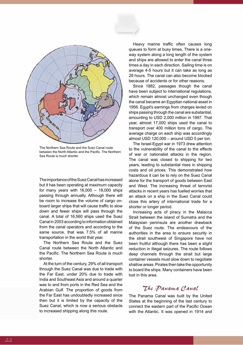
The Northern Sea Route and the Suez Canal route between the North Atlantic and the Pacific. The Northern Sea Route is much shorter.
At the turn of the century, 29% of all transport through the Suez Canal was due to trade with the Far East, under 20% due to trade with India and Southeast Asia and around a quarter was to and from ports in the Red Sea and the Arabian Gulf. The proportion of goods from the Far East has undoubtedly increased since then but it is limited by the capacity of the Suez Canal, which is now a serious obstacle to increased shipping along this route.
Heavy marine traffic often causes long queues to form at busy times. There is a one-way system along a long length of the system and ships are allowed to enter the canal three times a day in each direction. Sailing time is on average 4-5 hours but it can take as long as 28 hours. The canal can also become blocked because of accidents or for other reasons.
Since 1882, passages though the canal have been subject to international regulations, which remain almost unchanged even though the canal became an Egyptian national asset in 1956. Egypt's earnings from charges levied on ships passing through the canal are substantial, amounting to USD 2,000 million in 1997. That year, almost 17,000 ships used the canal to transport over 400 million tons of cargo. The average charge on each ship was accordingly almost USD 120,000 – around USD 5 per ton.
The Israel-Egypt war in 1973 drew attention to the vulnerability of the canal to the effects of war or nationalist attacks in the region. The canal was closed to shipping for two years, leading to substantial rises in shipping costs and oil prices. This demonstrated how hazardous it can be to rely on the Suez Canal alone for the transport of goods between East and West. The increasing threat of terrorist attacks in recent years has fuelled worries that an attack on a ship in the Suez Canal could close this artery of international trade for a shorter or longer period.
Increasing acts of piracy in the Malacca Strait between the island of Sumatra and the Malaysian peninsula are another drawback of the Suez route. The endeavours of the authorities in the area to ensure security in the strait southwest of Singapore have not been fruitful although there has been a slight reduction in illegal seizures. The route follows deep channels through the strait but large container vessels must slow down to negotiate shallow areas. Pirates then take the opportunity to board the ships. Many containers have been lost in this area.
The Panama CanalThe Panama Canal was built by the United States at the beginning of the last century to connect the eastern part of the Pacific Ocean with the Atlantic. It was opened in 1914 and
The Northern Sea Route and the Suez Canal route between the North Atlantic and the Pacific. The Northern Sea Route is much shorter.
23
immediately became an important shipping route between the Pacific coast of America and the Atlantic routes to Europe. A substantial quantity of goods also pass through the canal on their way to and from East Asia.
The Panama Canal was owned and operated by the United States until the year 2000 when it was given to the Panama government. It is 84 km long and leaves the Pacific Ocean to pass through tropical forest and marshland before reaching the Panama isthmus in the east, where it opens into the Caribbean Sea. The canal shortened the route from the North Atlantic to the North Pacific by as much as 9,000 nautical miles.
Much of the canal lies above sea level and ships are lifted in locks that limit the size of vessels that can be accommodated. Ships are transferred in locks from the Atlantic, to the River Chagres and up into Lake Gatún. From there they passes into the Gaillard Channel, which, with its cliffs, is one of the narrowest parts of the system. Two more locks must be negotiated before reaching the Pacific Ocean.
The Panama Canal is suitable for ships up to 274.3 m with a maximum beam of 32 m and a draught of up to 11.3 m, enough for ships carrying 4,500 containers. The canal is therefore too small for ships that are now common on longer shipping routes.
The Panama governemt has made plans to increase the capacity of the canal and build new locks alongside the existing locks, deepen the channels and make them wider so that the canal will accommodate ships carrying up to 5,600 containers. The total cost of the project is estimated 5.5 – 7.5 billion US dollars. It is expected to take 7 years to complete with contruction beginning in 2007 at the earliest. However, these extensions will not be sufficient for the new generation of merchant vessels that ply long routes.
The Northern Sea Route as a Shipping Route
The assumption that the Northern Sea Route could become an important trade route in the future depends on sailing conditions and on the need for such a shipping route.
Climate change in the North, as discussed in a previous chapter, and new marine technology
suggest that the first of these two conditions will be met within a few decades or at least by the end of this century. Increasing demand for cargo space between the growing economic region in the North Pacific and the industrial nations of the North Atlantic together with the limitations of the Suez and Panama Canals indicate that shipping across the polar region could become considerable should the routes become passable for merchant shipping.
The canals cannot meet the requirements of carriers operating between the North Pacific and the North Atlantic without considerable and extremely expensive expansion work. The opening of the Northern Sea Route will greatly reduce the need for such construction.
Undoubtedly, attempts will be made to meet increased transportation needs by using overland methods, directly over Eurasia from the Far Eastern coast to the Baltic and Atlantic ports in North Norway. Even with improvements, however, this sort of transport will never cope with more than a fraction of the demand, even if the rail network is extended, because the system will have to operate at full capacity just to fulfil future domestic needs in Eurasia, Central and West China and Central Asia.
The use of the shipping route around the Cape of Good Hope in South Africa to meet increasing demand for transportation between the North Atlantic and Asia is also fraught with difficulties. The merchant fleet is currently operating at full capacity and making deliveries that way extend voyage times and reduce the number of trips made by each ship. This would bring increases in transport costs, lengthen delivery times and reduce the competitiveness of the North Atlantic region in industries where part of the production process occurs in Asia. Furthermore, economic ties between Western Europe, the east coast of North America and the growing economies of East Asia will weaken.
The opening of the Northern Sea Route will prevent such developments, shorten transport times and strengthen ties between the West and the new industrial nations in the Far East. It could lever improvements in the global economy in the same way as the opening of the Suez Canal. The distance from Yokohama in Japan to Hamburg in Germany would be cut
24
from 11,400 nautical miles through the Suez Canal to 6,600 miles by the Northern Sea Route, a reduction of 42%. The same applies when the Northern Sea Route is compared to shipping routes from the North Pacific to Europe via the Panama Canal. Distances are halved when the Northern Sea Route is used.
Security concerns could bring about a speedier opening of the Northern Sea Route and drive forward the building of a new generation of ice-class super container ships even before melting of the ice makes the route passable for ordinary vessels. The vulnerability of the Suez and Panama canals to terrorist attacks, nationalist aggression or war is far from satisfactory in times of international cooperation in industry and commerce.
On the other hand, it would be unwise to allow the automatic transfer of shipping from other routes to the Northern Sea Route even though the route is relatively clear and passable. The feasibility of shipping routes and transportation is determined by a host of different factors, including freight volume, tonnage, size of vessels, duration of voyage, navigation conditions, the legal environment, safety and security.
Shipping companies have invested in the current shipping routes and the transhipment ports that serve them. Their fleets require adequate facilities and assistance in port. Maersk Sealand, the world's largest shipping company, is developing facilities in Tanjung Pelepas, Malaysia, which the company has designated to become their central transhipment port for shipments between the Pacific Ocean and the North Atlantic Region instead of Singapore. The efficiency of new shipping routes and the extent of shipments would need to be highly significant before Maersk would consider reshaping its shipping network and moving its Asian operations from Tanjung Pelepas. The same applies to other shipping companies.
In order to assess demand for new shipping routes and the probable use of the Northern Sea Route, it is necessary to evaluate the magnitude of current shipments between respective global regions and their probable future levels. Economic growth and development in the respective regions gives some indications.
The effectiveness of a shipping route is decided principally by shipping costs on that route compared with others. Factors contributing towards shipping costs include shipping time, vessel size, ship utilisation, fuel costs, shipbuilding costs, crew costs, port duties, sailing charges, canal and channel charges and other expenses because of essential services.
If the Northern Sea Route becomes ice-free it will be a relatively simple matter to compare its efficiency with that of other options as it will be based on sailing distance, which is directly related to sailing time. It will also be passable for larger and deeper ships that cannot use the canals. This will encourage shipments between distant harbours and further increase the competitiveness of the route. The same applies when delays and charges relating to the Suez Canal are considered.
On the other hand, it is more difficult to assess the efficiency of the route if it is not entirely ice-free and ships have to be strengthened, thus increasing shipbuilding costs and required engine power, with ensuing increases in fuel costs and sailing times.
Distances of Major Sailing Routes
The distances between important ports in the Pacific and Atlantic Oceans using different shipping routes gives an indication of how significant the Northern Sea Route could become compared to current routes, should it become completely ice-free.
Hong Kong is the same distance from Rotterdam and other ports in North Europe via either the Northern Sea Route or the Suez Canal. The Northern Sea Route to North Europe is therefore shorter for all ports northeast of Hong Kong but the Suez route is shorter for all ports to the southwest.
The equidistant point for shipments from New York and other ports on the east coast of North America is further south, at Manila. On the other hand, the Suez Canal route to North Europe and the east coast of North America is shorter from Vietnam, Thailand and Singapore.
East Asia lies entirely within the zone affected by the Northern Sea Route both for
25
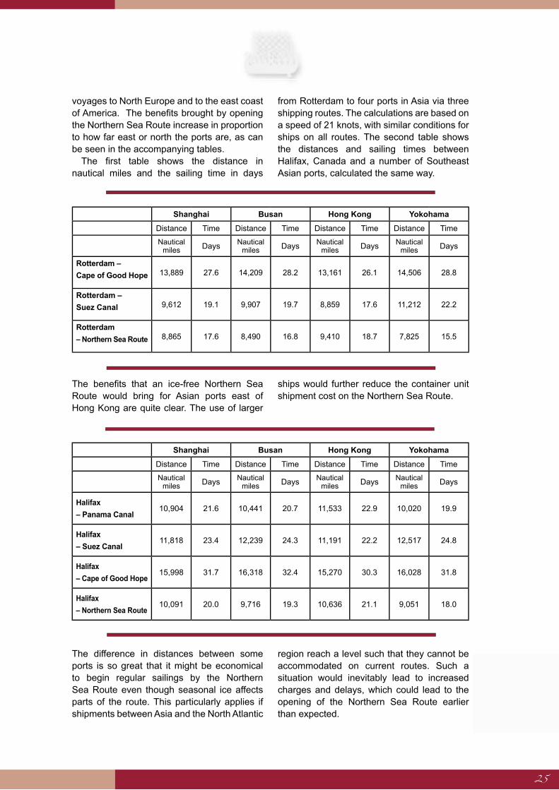
voyages to North Europe and to the east coast of America. The benefits brought by opening the Northern Sea Route increase in proportion to how far east or north the ports are, as can be seen in the accompanying tables.
The first table shows the distance in nautical miles and the sailing time in days
from Rotterdam to four ports in Asia via three shipping routes. The calculations are based on a speed of 21 knots, with similar conditions for ships on all routes. The second table shows the distances and sailing times between Halifax, Canada and a number of Southeast Asian ports, calculated the same way.
The benefits that an ice-free Northern Sea Route would bring for Asian ports east of Hong Kong are quite clear. The use of larger
ships would further reduce the container unit shipment cost on the Northern Sea Route.
The difference in distances between some ports is so great that it might be economical to begin regular sailings by the Northern Sea Route even though seasonal ice affects parts of the route. This particularly applies if shipments between Asia and the North Atlantic
region reach a level such that they cannot be accommodated on current routes. Such a situation would inevitably lead to increased charges and delays, which could lead to the opening of the Northern Sea Route earlier than expected.
Shanghai Busan Hong Kong Yokohama
Distance Time Distance Time Distance Time Distance Time
Nautical miles Days Nautical
miles Days Nautical miles Days Nautical
miles Days
Rotterdam –
Cape of Good Hope 13,889 27.6 14,209 28.2 13,161 26.1 14,506 28.8
Rotterdam –
Suez Canal 9,612 19.1 9,907 19.7 8,859 17.6 11,212 22.2
Rotterdam
– Northern Sea Route 8,865 17.6 8,490 16.8 9,410 18.7 7,825 15.5
Shanghai Busan Hong Kong Yokohama
Distance Time Distance Time Distance Time Distance Time
Nautical miles Days Nautical
miles Days Nautical miles Days Nautical
miles Days
Halifax
– Panama Canal10,904 21.6 10,441 20.7 11,533 22.9 10,020 19.9
Halifax
– Suez Canal11,818 23.4 12,239 24.3 11,191 22.2 12,517 24.8
Halifax
– Cape of Good Hope15,998 31.7 16,318 32.4 15,270 30.3 16,028 31.8
Halifax
– Northern Sea Route10,091 20.0 9,716 19.3 10,636 21.1 9,051 18.0
26
Sailing Routes and the Size of Ships
The size of ships inevitably influences on route planning and port selection. Developments have for many years tended towards increasingly large vessels. This could be highly significant for the future of the outer Northern Sea Route where there are no size restrictions.
Container unit costs are lower for larger vessels. Ship size is, however, restricted by the limitations of current shipping routes and port installations.
The maximum size of ships using the Panama Canal is fixed at 4000-5000 container units3, known as Panamax, which means
that the canal is not an option for the new generation of large container ships that are twice that size. More than 12% of the world's container ships were larger Panamax in 1995 and that ratio is expected to reach 33% by 2010. The largest container ships in existence today are capable of carrying around 10,000 TEU. Reports suggest that shipbuilders are already working on vessels that can be loaded with up to 12,000 TEU.
Increased trade between China and the West has fuelled the development of ever larger container ships for use on long shipping routes.
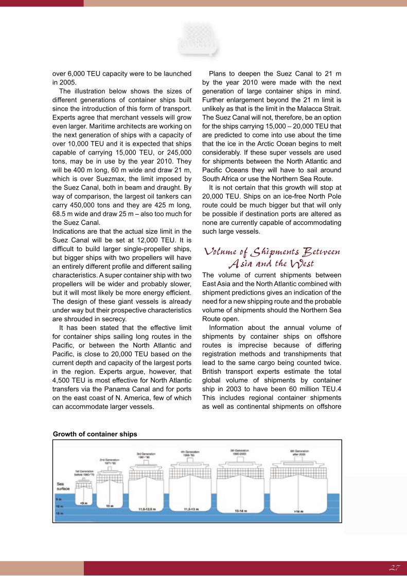
Increases in shipping capacity are mostly in the largest ship classes. Thirty-three ships with
New ship orders by vessel size4
In use Ordered for 2003 Ordered for 2004 Ordered for 2005
Size TEU Quantity TEU Quantity TEU Quantity TEU Quantity TEU
000-499 429 132,157 1 350 4 1,800 0 0
500-999 566 402,365 20 14,711 24 18,848 5 4,404
1000-1999 902 1,267,176 22 31,558 19 28,948 6 9,320
2000-2999 467 1,176,730 30 76,990 25 61,926 9 23,188
3000-3999 277 950,672 7 21,637 9 27,846 0 0
4000-4999 214 937,507 18 79,132 31 139,961 30 126,036
5000-5999 138 761,153 7 38,942 32 170,669 19 97,394
Over 6000 98 641,258 9 60,301 23 168,478 33 264,646
New ship orders by vessel size4
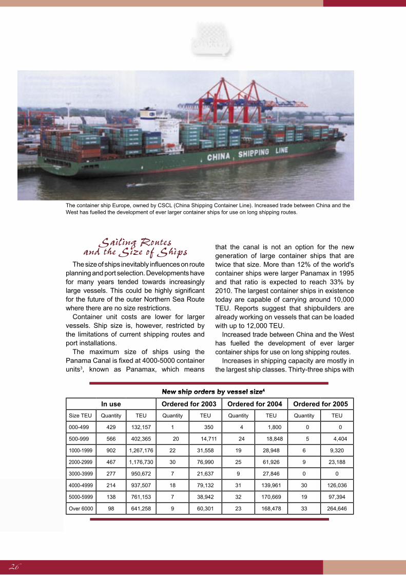
The container ship Europe, owned by CSCL (China Shipping Container Line). Increased trade between China and the West has fuelled the development of ever larger container ships for use on long shipping routes.
27
over 6,000 TEU capacity were to be launched in 2005.
The illustration below shows the sizes of different generations of container ships built since the introduction of this form of transport. Experts agree that merchant vessels will grow even larger. Maritime architects are working on the next generation of ships with a capacity of over 10,000 TEU and it is expected that ships capable of carrying 15,000 TEU, or 245,000 tons, may be in use by the year 2010. They will be 400 m long, 60 m wide and draw 21 m, which is over Suezmax, the limit imposed by the Suez Canal, both in beam and draught. By way of comparison, the largest oil tankers can carry 450,000 tons and they are 425 m long, 68.5 m wide and draw 25 m – also too much for the Suez Canal.Indications are that the actual size limit in the Suez Canal will be set at 12,000 TEU. It is difficult to build larger single-propeller ships, but bigger ships with two propellers will have an entirely different profile and different sailing characteristics. A super container ship with two propellers will be wider and probably slower, but it will most likely be more energy efficient. The design of these giant vessels is already under way but their prospective characteristics are shrouded in secrecy.
It has been stated that the effective limit for container ships sailing long routes in the Pacific, or between the North Atlantic and Pacific, is close to 20,000 TEU based on the current depth and capacity of the largest ports in the region. Experts argue, however, that 4,500 TEU is most effective for North Atlantic transfers via the Panama Canal and for ports on the east coast of N. America, few of which can accommodate larger vessels.
Plans to deepen the Suez Canal to 21 m by the year 2010 were made with the next generation of large container ships in mind. Further enlargement beyond the 21 m limit is unlikely as that is the limit in the Malacca Strait. The Suez Canal will not, therefore, be an option for the ships carrying 15,000 – 20,000 TEU that are predicted to come into use about the time that the ice in the Arctic Ocean begins to melt considerably. If these super vessels are used for shipments between the North Atlantic and Pacific Oceans they will have to sail around South Africa or use the Northern Sea Route.
It is not certain that this growth will stop at 20,000 TEU. Ships on an ice-free North Pole route could be much bigger but that will only be possible if destination ports are altered as none are currently capable of accommodating such large vessels.
Volume of Shipments Between Asia and the West
The volume of current shipments between East Asia and the North Atlantic combined with shipment predictions gives an indication of the need for a new shipping route and the probable volume of shipments should the Northern Sea Route open.
Information about the annual volume of shipments by container ships on offshore routes is imprecise because of differing registration methods and transhipments that lead to the same cargo being counted twice. British transport experts estimate the total global volume of shipments by container ship in 2003 to have been 60 million TEU.4 This includes regional container shipments as well as continental shipments on offshore
Growth of container ships

28
routes. It is estimated that 31 million TEU were transported that year on the 12 most important long distance routes, which is 80% of all intercontinental container shipments.5
Shipments through the Suez Canal totalled 7.2 million TEU in 2003, of which 4.8 million went from Asia to the West and 2.4 million in an easterly direction. Almost half were trans-ported between Asian ports east of Hong Kong and North Europe. The table to the right shows shipments between those regions via the Suez Canal in 2003, in thousands of units.6
Most of these shipments would presumably go by the Northern Sea Route were it passable. Container shipments between Asia and the east coast of the United States and Western Europe that are transported via the Panama Canal can also be added to this total. Estimations put that figure at 2,000,000 TEU in 2003, of which 1.5 million went from Asia, over the Pacific into the North Atlantic and 600,000 TEU travelled in the opposite direction.
The oil tanker Tempera, 106,000 tons, designed for sailing in ice as well as on open seas. It was the only oil tanker that could sail without the assistance of ice-breakers in the Baltic during the winter of 2003 when the ice was 80 cm thick.
There are, in addition, shipments across the Pacific between the west coast of the United States and Asia that are part of trade between the east coast of the USA and Asia. In total, 8.3 million TEU were shipped by this route in 2003, of which 5.9 million units went from Asia to the American Pacific coast and 2.4 million to Asia. It is difficult to assess what proportion of these shipments went across the American mainland all the way to the east coast, but it is unlikely to be very much because of limited transport capacity.
Plans by Kværner Masa Yards of Finland for a twin-bow ship designed to sail in open waters and in ice. It has a traditional bow for sailing on open seas while the stern is designed for ice-breaking and is used as the bow in areas where there is a large amount of ice. In this case the propeller can be used to grind a route through thick spurs of ice.
The above data shows that container shipments over the Arctic, in ice-free conditions, could total 5 – 6 million TEU per annum if all voyages that are shorter via the Northern Sea Route actually use the route. It is probable that shorter routes and correspondingly lower shipment costs would lead to an increase in shipping.
The Future of Container Shipments
Shipping trends and the predictable need for increased shipping capacity between distant parts of the world are decisive factors in determining if and when new routes over the Arctic will be opened. The Suez and Panama Canals barely accommodate current shipping between the North Atlantic and Pacific Oceans and costly expansion work is about to begin.
An examination of international trade in recent decades reveals an annual increase of 6% since 1950 while at the same time the world's economies have grown by 4% per annum. International trade has increased faster then economic growth. All indications are that this development will continue in future years and that international shipments will rise even faster, especially on longer intercontinental routes. According to figures issued by World Trade Organisation, international trade grew by 12% in millennium year 2000, remained static in 2001 because of a downturn in the world economy, but recovered quickly to increase by 4.5% in 2003 when economic growth was measured at 2.5%.
The growing use of computer networks in international trade has contributed to the
TotalTo N.
EuropeFrom N. Europe
China 2,060 1,548 512
Japan 825 354 471
South Korea 332 153 179
Taiwan 290 146 144
Grand total 3,507 2,201 1,315
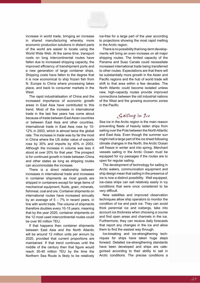
29
increase in world trade, bringing an increase in shared manufacturing whereby more economic production solutions in distant parts of the world are easier to locate using the World Wide Web. At the same time, transport costs on long intercontinental routes have fallen due to increased shipping capacity, the improved efficiency of transhipment ports and a new generation of large container ships. Shipping costs have fallen to the degree that it is now economical to ship frozen fish from N. Europe to China where processing takes place, and back to consumer markets in the West.
The rapid industrialisation of China and the increased importance of economic growth areas in East Asia have contributed to this trend. Most of the increase in international trade in the last few years has come about because of trade between East Asian countries or between East Asia and other countries. International trade in East Asia rose by 10-12% in 2003, which is almost twice the global rate. The increase in trade was by far the most in China where the US dollar value of exports rose by 35% and imports by 40% in 2003. Although the increase in volume was less it stood at over 20% for that year. The prospect is for continued growth in trade between China and other states as long as shipping routes can accommodate the increase.
There is a direct relationship between increases in international trade and increases in container shipments as most goods are shipped in containers except for large items of mechanical equipment, fluids, grain, minerals, fishmeal, coal and ore. Container shipments on international routes have increased annually by an average of 5 – 7% in recent years, in line with world trade. The volume of shipments therefore doubles every 10-15 years, meaning that by the year 2020, container shipments on the 12 most used intercontinental routes could be over 60 million TEU.
If that happens then container shipments between East Asia and the North Atlantic will be around 12 million units per annum by 2020, provided that current proportions are maintained. If that trend continues until the middle of the century then that figure would reach 30-40 million TEU by the time the Northern Sea Route is likely to be relatively
ice-free for a large part of the year according to projections showing the most rapid melting in the Arctic region.
There is no possibility that long-term develop-ments will bring an even increase on all major shipping routes. The limited capacity of the Panama and Suez Canals could necessitate increased international trade being transferred to other routes. Expectations are that there will be substantially more growth in the Asian and Pacific regions and the hub of world trade will shift to that area within a few decades. The North Atlantic could become isolated unless new, high-capacity routes provide improved connections between the old industrial nations of the West and the growing economic zones in the Pacific.
Sailing in IceSea ice in the Arctic region is the main reason preventing fleets of heavily laden ships from sailing over the Pole between the North Atlantic and East Asia. Even though the summer sun might melt a large part of the ice sheet following climate changes in the North, the Arctic Ocean will freeze in winter and into spring. Merchant vessels sailing in the Arctic Ocean must be equipped for icy passages if the routes are to open for regular sailing.
The development of technology for sailing in Arctic waters, communication equipment and ship design mean that sailing in the presence of ice is now a distinct possibility. Well equipped, ice-class ships can sail relatively easily in icy conditions that were once considered to be very difficult.
New satellites and improved observation techniques allow ship operators to monitor the condition of ice and pack ice. They can avoid thick perennial ice and icebergs, take into account ice thickness when choosing a course and find open areas and channels in the ice. Furthermore, they can receive daily forecasts that report any changes in the ice and allow them to find the easiest way through.
Ice-breaking and ice-strengthening tech-niques for ships have taken huge steps forward. Detailed ice-strengthening standards have been developed and ships are cate-gorised according to their ability to sail in Arctic conditions. The precise conditions a

30
ship can operate in are specified, from a few centimetres of winter ice up to several metres of thick perennial ice. Several such standards are in use including the Finnish-Swedish Ice Class Rules that divide ships into two classes according to whether they are designed for sailing in relatively thin ice as in the Baltic or in thick perennial Arctic ice. These two classes are divided into subcategories with precise specifications concerning strengthening stand-ards. Inconsistency between classification standards in different countries restricts ship operators from moving ice-class vessels between regions. International shipping organi-sations are working towards the unification of the standards, which will simplify assessment of ice sailing capabilities. Unification could have significance for summer voyages on the Northern Sea Route as it would allow for the transfer of ships that are used for winter transport in the Baltic to the Arctic Ocean during the summer months and improve their operating efficiency. That will still require permission from Russian authorities and conformance with their sailing regulations for the Northern Sea Route.
A clear delineation exists between ice-strength-ened merchant vessels and ice-breakers. The
former can withstand high levels of abrasive contact with ice and ice floes but need the assistance of and ice-breaker to pass through thick ice. Ice-breakers have specially designed bows that can break ice but give them undesirable sailing characteristics in open sea so that they only move slowly and use a lot of fuel.
Merchant vessels only ever sail part of their route in ice and their bows are designed with this in mind. They have limited ice breaking capability that at best allows them to cut through annual winter ice but leaves them requiring the assistance of an ice-breaker to open a path through thick ice. An ice-breaker leading one or more cargo vessels through the ice is a tried and tested technique. Very large container ships may need two ice-breakers to clear a wide enough path. The path may become choked with drifting ice and the ships can then get stuck in the ice with resulting long delays while they are freed.
Sailing in ice with the assistance of ice-breakers is both costly and time-consuming as well as being reliant on their availability at the required location.
The Finnish shipbuilders Aker Arctic (formerly Kvaerner Masa-Yards) have designed a new type of double-acting vessel that has the same open sea characteristics as other ships in its class combined with the breaking capacity of a powerful ice-breaker. The bow is shaped for regular sailing but the stern is designed for ice-breaking. The ship is turned about when there is heavy ice and the stern used as the bow. When the ice is so thick that the stern cannot cut through, the propeller can be used to chop a way through.
Aker Arctic is the world's largest and best known builder of ice-breakers and most or Russia's fleet of such vessels was built by the company. Four ships had been built using the new design by 2006, one of which is operating in the Arctic. The Norilsk Nickel is a 14,500 ton container ship used to export nickel from Northwest Russia on the Yenesei river and the Kara Sea. It carries up to 400 TEU and is capable of sailing in conditions of 1.5 meters of Arctic ice without ice-breaker assistance.
The Norilsk Nickel was the first ship of its kind on the Northern Sea Route, but two 70.000 tonn double-acting Arctic shuttle tankers are to be delivered in 2007 and 2008
former can withstand high levels of abrasive contact with ice and ice floes but need the assistance of and ice-breaker to pass through thick ice. Ice-breakers have specially designed bows that can break ice but give them undesirable sailing characteristics in open sea so that they only move slowly and use a lot of fuel.
route in ice and their bows are designed with this in mind. They have limited ice breaking capability that at best allows them to cut through annual winter ice but leaves them requiring the assistance of an ice-breaker to open a path through thick ice. An ice-breaker leading one or more cargo vessels through the ice is a tried and tested technique. Very large container ships may need two ice-breakers to clear a wide enough path. The path may become choked with drifting ice and the ships can then get stuck in the ice with resulting long The oil tanker Tempera, 106,000 tons, designed for
sailing in ice as well as on open seas. It was the only oil tanker that could sail without the assistance of ice-breakers in the Baltic during the winter of 2003 when the ice was 80 cm thick.
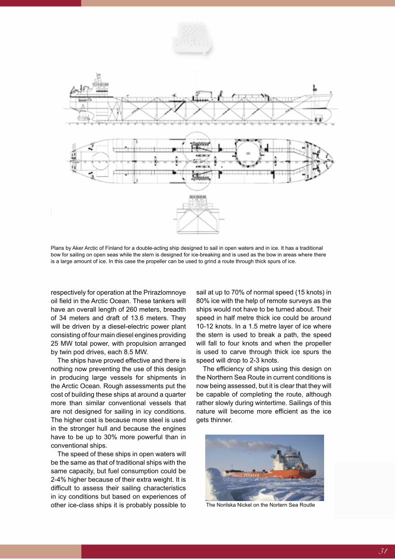
31
respectively for operation at the Prirazlomnoye oil field in the Arctic Ocean. These tankers will have an overall length of 260 meters, breadth of 34 meters and draft of 13.6 meters. They will be driven by a diesel-electric power plant consisting of four main diesel engines providing 25 MW total power, with propulsion arranged by twin pod drives, each 8.5 MW.
The ships have proved effective and there is nothing now preventing the use of this design in producing large vessels for shipments in the Arctic Ocean. Rough assessments put the cost of building these ships at around a quarter more than similar conventional vessels that are not designed for sailing in icy conditions. The higher cost is because more steel is used in the stronger hull and because the engines have to be up to 30% more powerful than in conventional ships.
The speed of these ships in open waters will be the same as that of traditional ships with the same capacity, but fuel consumption could be 2-4% higher because of their extra weight. It is difficult to assess their sailing characteristics in icy conditions but based on experiences of other ice-class ships it is probably possible to
sail at up to 70% of normal speed (15 knots) in 80% ice with the help of remote surveys as the ships would not have to be turned about. Their speed in half metre thick ice could be around 10-12 knots. In a 1.5 metre layer of ice where the stern is used to break a path, the speed will fall to four knots and when the propeller is used to carve through thick ice spurs the speed will drop to 2-3 knots.
The efficiency of ships using this design on the Northern Sea Route in current conditions is now being assessed, but it is clear that they will be capable of completing the route, although rather slowly during wintertime. Sailings of this nature will become more efficient as the ice gets thinner.
Plans by Aker Arctic of Finland for a double-acting ship designed to sail in open waters and in ice. It has a traditional bow for sailing on open seas while the stern is designed for ice-breaking and is used as the bow in areas where there is a large amount of ice. In this case the propeller can be used to grind a route through thick spurs of ice.
The Norilska Nickel on the Nortern Sea Routle
32
The Increasing Importance of Transhipment Ports
A massive increase in global shipping has led to the use of larger, more efficient merchant vessels on the world's main shipping routes. This trend has in turn brought about the development of bigger centralised transhipment ports, especially in busy regions like East Asia. Freight is transferred to smaller ships for distribution from large ports. It has been estimated that 25-30% of all containers shipped on major international routes are transhipped, and that percentage is rising sharply.7
Once the containers reach a transhipment port they are grouped by destination, ready for shipping onward. Very large container ships with capacities of up to 10,000 TEU transport goods between large transhipment ports on long routes, but smaller ships are used to deliver the shipments to other smaller ports. In this way the total distance each container travels is reduced and the fleet is employed more efficiently, thus markedly reducing shipping costs. The use of large vessels for container shipments on long international routes further reduces the unit cost of transporting the containers.
The time each ship spends in port is getting shorter as specialisation and the use of very large cranes and other loading equipment in transhipment ports reduces the time taken to load and unload cargoes.
Larger shipping companies in particular use the transhipment ports to improve their transport networks and reduce costs. Smaller shipping companies with smaller vessels are not competitive on longer routes and their operations are restricted to regional shipments on shorter routes.
Not all governments are fully aware of these developments. Some have tended to use port development simply as part of local urban development. Competition among ports is fierce and has led to dumping of services, inefficient use of harbour facilities and overinvestment. The emergence of transhipment ports could mean that fewer ships come into neighbouring ports as the transport network is simplified. It is important, therefore, to consider carefully the location of new transhipment ports and their effect on shipping routes.
The location of transhipment ports and the adequacy of their facilities determine their performance and whether or not a port will establish itself as a link in the shipping chain. They must be close to several shipping routes and preferably at the end of a major intercontinental route. The depth of approach must be enough for the largest vessels that currently draw up to 20 metres but are expected to surpass this figure in the near future. There must be sufficient turning room in the port and space on land for freight transfers, container storage and related industries. Furthermore, the
Central Transhipment Ports
Central transhipment ports play an increasingly important role in modern logistical coordination. It has been estimated that approximately 25-30% of all containers used in international marine transport were transhipped in 1999-2000, and that percentage is rising sharply. The location of
transhipment ports and the adequacy of their facilities determine their performance and whether or not a port will establish itself as a link in the shipping chain. The proximity of shipping routes and a good location are essential conditions for a transhipment port. Iceland, situated in the northern
part of the North Atlantic, mid-way between North Europe and the east coast of North America, is ideal for such a port, which could serve equally as a transhipment hub for ships crossing the
North Atlantic as well as those using the Northern Sea Route when it opens. The deep fjords along the east coast and the fjords of Eyjafjörður and Hvalfjörður offer good natural conditions for
ports serving large vessels, and land is readily available for container storage areas. However, the advantages that Iceland has to offer as the location for a transhipment port are of little value unless
targeted action is taken to inform international shipping companies and awaken their interest.
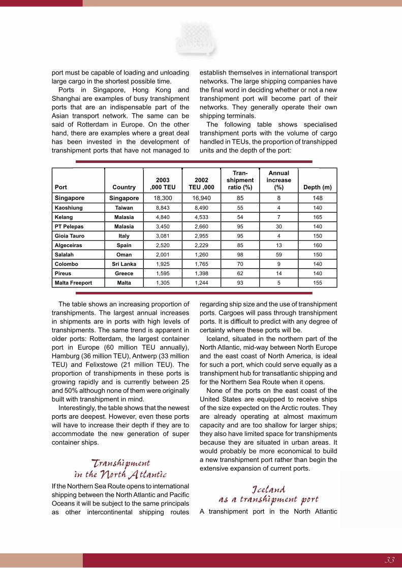
33
port must be capable of loading and unloading large cargo in the shortest possible time.
Ports in Singapore, Hong Kong and Shanghai are examples of busy transhipment ports that are an indispensable part of the Asian transport network. The same can be said of Rotterdam in Europe. On the other hand, there are examples where a great deal has been invested in the development of transhipment ports that have not managed to
establish themselves in international transport networks. The large shipping companies have the final word in deciding whether or not a new transhipment port will become part of their networks. They generally operate their own shipping terminals.
The following table shows specialised transhipment ports with the volume of cargo handled in TEUs, the proportion of transhipped units and the depth of the port:
The table shows an increasing proportion of transhipments. The largest annual increases in shipments are in ports with high levels of transhipments. The same trend is apparent in older ports: Rotterdam, the largest container port in Europe (60 million TEU annually), Hamburg (36 million TEU), Antwerp (33 million TEU) and Felixstowe (21 million TEU). The proportion of transhipments in these ports is growing rapidly and is currently between 25 and 50% although none of them were originally built with transhipment in mind.
Interestingly, the table shows that the newest ports are deepest. However, even these ports will have to increase their depth if they are to accommodate the new generation of super container ships.
Transhipment in the North Atlantic
If the Northern Sea Route opens to international shipping between the North Atlantic and Pacific Oceans it will be subject to the same principals as other intercontinental shipping routes
regarding ship size and the use of transhipment ports. Cargoes will pass through transhipment ports. It is difficult to predict with any degree of certainty where these ports will be.
Iceland, situated in the northern part of the North Atlantic, mid-way between North Europe and the east coast of North America, is ideal for such a port, which could serve equally as a transhipment hub for transatlantic shipping and for the Northern Sea Route when it opens.
None of the ports on the east coast of the United States are equipped to receive ships of the size expected on the Arctic routes. They are already operating at almost maximum capacity and are too shallow for larger ships; they also have limited space for transhipments because they are situated in urban areas. It would probably be more economical to build a new transhipment port rather than begin the extensive expansion of current ports.
Iceland as a transhipment port
A transhipment port in the North Atlantic
Port Country2003
,000 TEU2002
TEU ,000
Tran-shipment ratio (%)
Annual increase
(%) Depth (m)
Singapore Singapore 18,300 16,940 85 8 148
Kaoshiung Taiwan 8,843 8,490 55 4 140
Kelang Malasia 4,840 4,533 54 7 165
PT Pelepas Malasia 3,450 2,660 95 30 140
Gioia Tauro Italy 3,081 2,955 95 4 150
Algeceiras Spain 2,520 2,229 85 13 160
Salalah Oman 2,001 1,260 98 59 150
Colombo Sri Lanka 1,925 1,765 70 9 140
Pireus Greece 1,595 1,398 62 14 140
Malta Freeport Malta 1,305 1,244 93 5 155

34
would shorten the Arctic voyages of ice-class container. Shipments would be more economical as the ice-class vessels would not need to transport cargoes further afield.
The Northern Sea Route. The Aleutian Islands south of the Bering Strait would be a good location for a transhipment port in the Pacific, similar to Iceland in the North Atlantic.
A transhipment port located in Iceland could service both the east coast of North America and Northern Europe. That is hardly the case for ports in America or continental Europe, nor for locations in the United Kingdom. The port authorities in Narvik, North Norway, have shown interest in container transhipments in Iceland for shipments between the east coast of America and Narvik, which is connected to the North Scandinavian railway system and thus to Northwest Russia and on to East Asia. Norwegian interest is fuelled by limited storage space for containers in Narvik and transhipment to different destinations on the Atlantic coast of North America.
An Icelandic transhipment port would have the advantage over other locations of being able to serve routes over the North Atlantic between North America and Europe as well as routes to the north. A good air-traffic system, efficient international communication channels and a wide range of services make Iceland an attractive option in comparison to others in the north.
For similar reasons, a transhipment port would be desirable at the Pacific end of the Northern Sea Route if the route is opened
for shipping on a large-scale. The Aleutian Islands, south of the Bering Strait, have been suggested as a suitable location and could handle shipping to ports in East Asia and the west coast of America. There are a number of good potential port locations on the islands, for instance at Adak or Dutch Harbour.
Location of Transhipment PortsWhen choosing the site of a transhipment port it is essential to consider its geographical location, natural conditions and services.
The port must be close to a number of busy shipping routes, preferably at a point where the routes divide and ships then head for a number of destinations. This is the main reason for the success of Singapore as a transhipment port at the end of the Suez Canal route, and for the rapid expansion of the Spanish port of Algeciras at the mouth of the Mediterranean.
In busy shipping areas with a lot of subsidiary ports, a centralised transhipment port can be important for regional transport where it is more economical to ship goods to a single centre rather than over a complex system of interconnecting routes.
Proximity to urban centres is also an advantage, especially initially, as was the case in places like Rotterdam, Hong Kong and Shanghai. Harbours like these are often at the mouths of rivers that provide
routes divide and ships then head for a number of destinations. This is the main reason for the success of Singapore as a transhipment port at the end of the Suez Canal route, and for the rapid expansion of the Spanish port of Algeciras at the mouth of the Mediterranean.
ports, a centralised transhipment port can be important for regional transport where it is more economical to ship goods to a single centre rather than over a complex system of interconnecting routes.
advantage, especially initially, as was the case in places like Rotterdam, Hong Kong and Shanghai. Harbours like these are often at the mouths of rivers that provide
The Northern Sea Route. The Aleutian Islands south of the Bering Strait would be a good location for a transhipment port in the Pacific, similar to Iceland in the North Atlantic. Design: SAV
Design: SAV
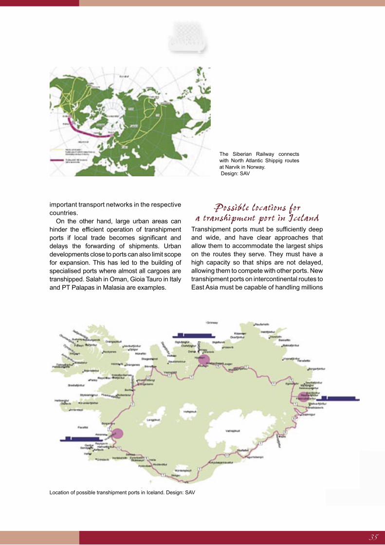
35
important transport networks in the respective countries.
On the other hand, large urban areas can hinder the efficient operation of transhipment ports if local trade becomes significant and delays the forwarding of shipments. Urban developments close to ports can also limit scope for expansion. This has led to the building of specialised ports where almost all cargoes are transhipped. Salah in Oman, Gioia Tauro in Italy and PT Palapas in Malasia are examples.
Possible locations for a transhipment port in Iceland
Transhipment ports must be sufficiently deep and wide, and have clear approaches that allow them to accommodate the largest ships on the routes they serve. They must have a high capacity so that ships are not delayed, allowing them to compete with other ports. New transhipment ports on intercontinental routes to East Asia must be capable of handling millions
Location of possible transhipment ports in Iceland. Design: SAV
The Siberian Railway connects with North Atlantic Shippig routes at Narvik in Norway. Design: SAV
36
of containers every year and provide berths up to 400 m in length and over 20 m deep.
Good shelter from swell and wind is essential; large ships are susceptible to strong winds as are large cranes. Land must be available to extend operations or build new wharfs to allow for future increases in shipping. Access to ancillary services and labour must be ensured.
Cheap electricity is advantageous and port operations demand a substantial supply of energy. Fuel must be available at competitive prices. Repair services, maintenance services and water must also be available at a reasonable cost. The largest vessels use thousands of tons of fuel for each voyage. The total fuel requirements of a relatively small international transhipment port would be similar to the current volume of oil and fuel used in Iceland. Building good oil storage facilities is an essential prerequisite for providing for the energy needs of a fleet of merchant ships.
Proximity to an international airport is no less important if the port is to fulfil its role as a link in the transport systems of international shipping companies.
The Size of Transhipment Ports
For a transhipment port to be competitive in the shipping world it must be capable of handling millions of containers every year. For comparison, annual shipments through the Port of Reykjavík are under 100,000 TEU even though it is one of the largest container ports in the Nordic countries.
It is informative to look at a Weser Port, currently under construction in Wilhelmshaven, Germany, in order to understand the probable size of a transhipment port that would serve the Northern Sea Route. Shipments there are expected to reach 2.7 million TEU by the year 2010. Allowance has been made for ships carrying up to 12,000 TEU although these vessels have yet to be built. They are expected to be up to 430 m long and 58 m wide with a draught of 16.5 m. Four wharfs will be built with a total length of 1,725 m. The port will be 18 m deep with a turning pool over 700 m across. Seventeen container cranes will be used and a large proportion of the containers will be
transported immediately by rail or road. There will be a 120 hectare container storage area and an industrial area of up to 570 hectares.
The total cost of the entire project will be around EUR 900 million with port costs reaching EUR 305 million. The cost of building up an internal port support system will be EUR 178 million.
The following example gives an idea of the size of a container port capable of handling 1 – 3 million TEU that would need to be built at the North Atlantic end of the Northern Sea Route.
It is expected that ships with a capacity of 15,000 to 20,000 TEU would be used on the route to improve competitiveness against the Suez Canal route, which cannot handle vessels of this size. They would be unloaded in the transhipment port and then loaded with containers to be shipped back to the Pacific. Containers will then be transported between the transhipment port and other North Atlantic destinations on board ships with a 4,500 TEU capacity (Panamax), suitable for most larger ports in the region.
In order to ship one million containers annually, i.e. 500,000 in each direction, 31 trips must be made by ships capable of carrying 18,000 TEU filled on average to 90% capacity.
Rapid progress is being made in the development of container cranes and they can currently handle 140,000 containers every year. Seven or eight cranes are required to transfer one million containers per annum. At this rate it takes 3.5 days to unload and reload each 18,000 unit container ship and 31 ships would then spend a total of 110 days each year in port.
This is barely satisfactory and attempts will be made to shorten this time with more cranes and better techniques, e.g. by loading and unloading on both sides of the ship, which would berth in a narrow dock with cranes on each side. This arrangement has been adopted in Antwerp.
Four 4,500 TEU ships are required to supply and distribute cargoes for each 18,000 TEU vessel. They need about 330 m alongside the wharf. If two of these ships are docked at one time along with an 18,000 TEU ship, so that a proportion of the containers can be transferred
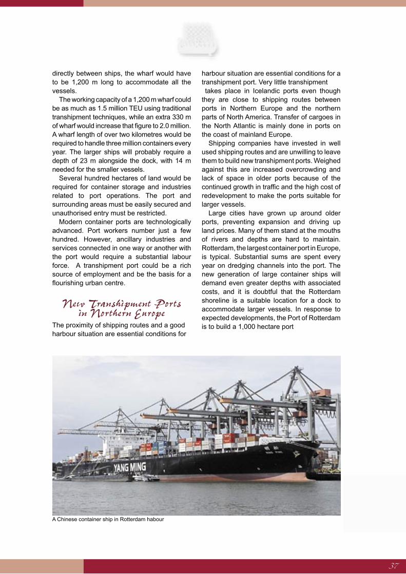
37
directly between ships, the wharf would have to be 1,200 m long to accommodate all the vessels.
The working capacity of a 1,200 m wharf could be as much as 1.5 million TEU using traditional transhipment techniques, while an extra 330 m of wharf would increase that figure to 2.0 million. A wharf length of over two kilometres would be required to handle three million containers every year. The larger ships will probably require a depth of 23 m alongside the dock, with 14 m needed for the smaller vessels.
Several hundred hectares of land would be required for container storage and industries related to port operations. The port and surrounding areas must be easily secured and unauthorised entry must be restricted.
Modern container ports are technologically advanced. Port workers number just a few hundred. However, ancillary industries and services connected in one way or another with the port would require a substantial labour force. A transhipment port could be a rich source of employment and be the basis for a flourishing urban centre.
New Transhipment Ports in Northern Europe
The proximity of shipping routes and a good harbour situation are essential conditions for
harbour situation are essential conditions for a transhipment port. Very little transhipment takes place in Icelandic ports even though they are close to shipping routes between ports in Northern Europe and the northern parts of North America. Transfer of cargoes in the North Atlantic is mainly done in ports on the coast of mainland Europe.
Shipping companies have invested in well used shipping routes and are unwilling to leave them to build new transhipment ports. Weighed against this are increased overcrowding and lack of space in older ports because of the continued growth in traffic and the high cost of redevelopment to make the ports suitable for larger vessels.
Large cities have grown up around older ports, preventing expansion and driving up land prices. Many of them stand at the mouths of rivers and depths are hard to maintain. Rotterdam, the largest container port in Europe, is typical. Substantial sums are spent every year on dredging channels into the port. The new generation of large container ships will demand even greater depths with associated costs, and it is doubtful that the Rotterdam shoreline is a suitable location for a dock to accommodate larger vessels. In response to expected developments, the Port of Rotterdam is to build a 1,000 hectare port
A Chinese container ship in Rotterdam habour
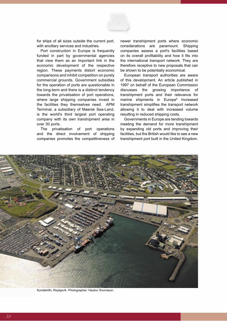
38
for ships of all sizes outside the current port, with ancillary services and industries.
Port construction in Europe is frequently funded in part by governmental agencies that view them as an important link in the economic development of the respective region. These payments distort economic comparisons and inhibit competition on purely commercial grounds. Government subsidies for the operation of ports are questionable in the long-term and there is a distinct tendency towards the privatisation of port operations, where large shipping companies invest in the facilities they themselves need. APM Terminal, a subsidiary of Maersk Sea-Land, is the world's third largest port operating company with its own transhipment area in over 30 ports.
The privatisation of port operations and the direct involvement of shipping companies promotes the competitiveness of
newer transhipment ports where economic considerations are paramount. Shipping companies assess a port's facilities based on its overall profitability and how it fits into the international transport network. They are therefore receptive to new proposals that can be shown to be potentially economical.
European transport authorities are aware of this development. An article published in 1997 on behalf of the European Commission discusses the growing importance of transhipment ports and their relevance for marine shipments in Europe8 Increased transhipment simplifies the transport network allowing it to deal with increased volume resulting in reduced shipping costs.
Governments in Europe are tending towards meeting the demand for more transhipment by expanding old ports and improving their facilities, but the British would like to see a new transhipment port built in the United Kingdom.
Sundahöfn, Reykjavík. Photographer: Haukur Snorrason.
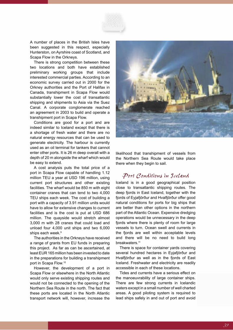
39
A number of places in the British Isles have been suggested in this respect, especially Hunterston, on Ayrshire coast of Scotland, and Scapa Flow in the Orkneys.
There is strong competition between these two locations and both have established preliminary working groups that include interested commercial parties. According to an economic survey carried out in 2000 for the Orkney authorities and the Port of Halifax in Canada, transhipment in Scapa Flow would substantially lower the cost of transatlantic shipping and shipments to Asia via the Suez Canal. A corporate conglomerate reached an agreement in 2003 to build and operate a transhipment port in Scapa Flow.
Conditions are good for a port and are indeed similar to Iceland except that there is a shortage of fresh water and there are no natural energy resources that can be used to generate electricity. The harbour is currently used as an oil terminal for tankers that cannot enter other ports. It is 26 m deep overall with a depth of 20 m alongside the wharf which would be easy to extend.
A cost analysis puts the total price of a port in Scapa Flow capable of handling 1.12 million TEU a year at USD 196 million, using current port structures and other existing facilities. The wharf would be 850 m with eight container cranes that can tend to two 4,000 TEU ships each week. The cost of building a port with a capacity of 3.91 million units would have to allow for extensive changes to current facilities and is the cost is put at USD 686 million. The quayside would stretch almost 3,000 m with 28 cranes that could load and unload four 4,000 unit ships and two 6,000 ships each week.9
The authorities in the Orkneys have received a range of grants from EU funds in preparing this project. As far as can be ascertained, at least EUR 165 million has been invested to date in the preparations for building a transhipment port in Scapa Flow.10
However, the development of a port in Scapa Flow or elsewhere in the North Atlantic would only serve existing shipping routes and would not be connected to the opening of the Northern Sea Route in the north. The fact that these ports are located in the North Atlantic transport network will, however, increase the
likelihood that transhipment of vessels from the Northern Sea Route would take place there when they begin to sail.
Port Conditions in IcelandIceland is in a good geographical position close to transatlantic shipping routes. The deep fjords in East Iceland, together with the fjords of Eyjafjörður and Hvalfjörður offer good natural conditions for ports for big ships that are better than other options in the northern part of the Atlantic Ocean. Expensive dredging operations would be unnecessary in the deep fjords where there is plenty of room for large vessels to turn. Ocean swell and currents in the fjords are well within acceptable levels and there will be no need to build long breakwaters.11
There is space for container yards covering several hundred hectares in Eyjafjörður and Hvalfjörður as well as in the fjords of East Iceland. Freshwater and electricity are readily accessible in each of these locations.
Tides and currents have a serious effect on the manoeuvrability of large container ships. There are few strong currents in Icelandic waters except in a small number of well charted areas. A good piloting system is required to lead ships safely in and out of port and avoid
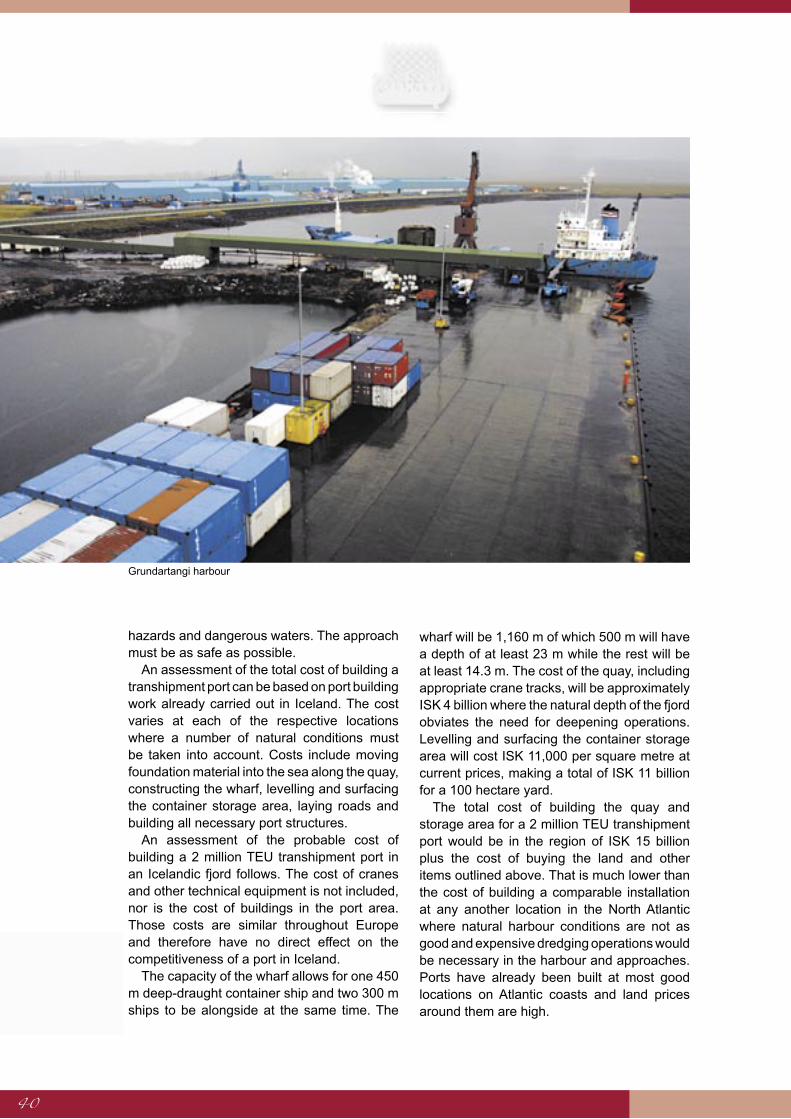
40
hazards and dangerous waters. The approach must be as safe as possible.
An assessment of the total cost of building a transhipment port can be based on port building work already carried out in Iceland. The cost varies at each of the respective locations where a number of natural conditions must be taken into account. Costs include moving foundation material into the sea along the quay, constructing the wharf, levelling and surfacing the container storage area, laying roads and building all necessary port structures.
An assessment of the probable cost of building a 2 million TEU transhipment port in an Icelandic fjord follows. The cost of cranes and other technical equipment is not included, nor is the cost of buildings in the port area. Those costs are similar throughout Europe and therefore have no direct effect on the competitiveness of a port in Iceland.
The capacity of the wharf allows for one 450 m deep-draught container ship and two 300 m ships to be alongside at the same time. The
wharf will be 1,160 m of which 500 m will have a depth of at least 23 m while the rest will be at least 14.3 m. The cost of the quay, including appropriate crane tracks, will be approximately ISK 4 billion where the natural depth of the fjord obviates the need for deepening operations. Levelling and surfacing the container storage area will cost ISK 11,000 per square metre at current prices, making a total of ISK 11 billion for a 100 hectare yard.
The total cost of building the quay and storage area for a 2 million TEU transhipment port would be in the region of ISK 15 billion plus the cost of buying the land and other items outlined above. That is much lower than the cost of building a comparable installation at any another location in the North Atlantic where natural harbour conditions are not as good and expensive dredging operations would be necessary in the harbour and approaches. Ports have already been built at most good locations on Atlantic coasts and land prices around them are high.
Grundartangi harbour
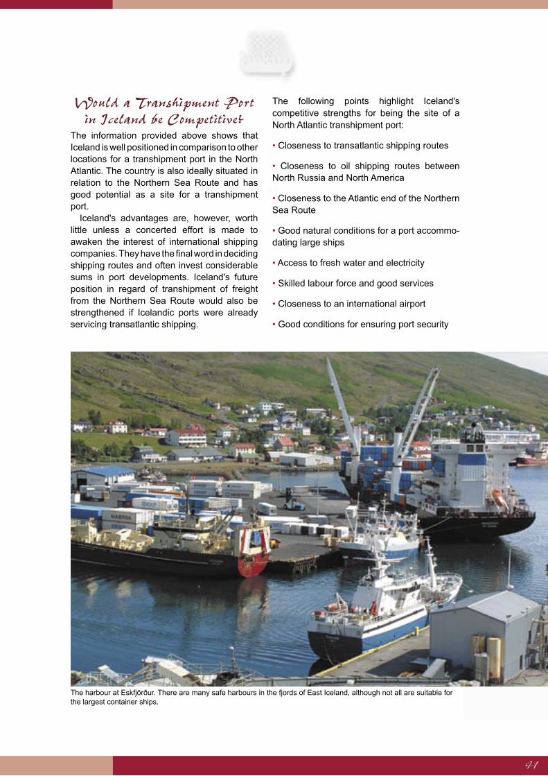
41
Would a Transhipment Port in Iceland be Competitive?
The information provided above shows that Iceland is well positioned in comparison to other locations for a transhipment port in the North Atlantic. The country is also ideally situated in relation to the Northern Sea Route and has good potential as a site for a transhipment port.
Iceland's advantages are, however, worth little unless a concerted effort is made to awaken the interest of international shipping companies. They have the final word in deciding shipping routes and often invest considerable sums in port developments. Iceland's future position in regard of transhipment of freight from the Northern Sea Route would also be strengthened if Icelandic ports were already servicing transatlantic shipping.
The following points highlight Iceland's competitive strengths for being the site of a North Atlantic transhipment port:
• Closeness to transatlantic shipping routes
• Closeness to oil shipping routes between North Russia and North America
• Closeness to the Atlantic end of the Northern Sea Route
• Good natural conditions for a port accommo-dating large ships
• Access to fresh water and electricity
• Skilled labour force and good services
• Closeness to an international airport
• Good conditions for ensuring port security
The harbour at Eskfjörður. There are many safe harbours in the fjords of East Iceland, although not all are suitable for the largest container ships.

42
Marine transport affects the environmental in a number of ways. Fossil fuel combustion pollutes both the air and the sea, as does the discharge of oil, refuse and sewage from ships. Organisms can be carried long distances in bilge water and reach parts of the world where they can disrupt the biological balance. However, shipping does not generally pose a great threat to the oceanic ecosystem except in and around ports. Discharges of waste from ships have been greatly reduced in recent decades following concerted action by the International Maritime Organisation and through the introduction of guidelines for sailing in polar regions, although they are not legally binding. The ecosystem of the sea can also be damaged by accidents, especially if the ships involved are carrying oil or other life-threatening materials, or are powered by nuclear fuel.
Iceland has been active in the battle against marine pollution. Sea food products account for 70% of exports from Iceland. Food sales are sensitive to the mention of pollution or the wholesomeness of the products. It is vital that purchasers and consumers of catches can be confident that the produce is healthy. The sea around Iceland is relatively clean and unpolluted, especially when compared to coastal and inshore waters of Europe such as the North Sea and the Baltic. The image of Iceland as a producer of wholesome sea
products is as important to Icelanders as the fishing grounds themselves. It is extremely important to reduce, as much as possible, the danger of environmental damage around Iceland.
An analysis of the most significant environmental impacts of shipping follows, with particular attention being paid to the possible effects of the Northern Sea Route.
Atmospheric PollutionMost ships use fossil fuels that produce pollutants on combustion, releasing oxides of nitrogen and sulphur as well as greenhouse gases, especially carbon dioxide. Local pollution produced by shipping is rarely a serious problem with the volume of polluting gases being just a fraction of that produced in urban areas and by land-based industries. Oxides of nitrogen and sulphur compounds break down quickly in offshore regions and have little effect on the ecology of shipping routes, except perhaps in the busiest parts of the English Channel and the Malacca Strait. Emissions of sulphur from ships account for just 4% of global output while nitrogen oxides (NOx) account for 7%.
From 1-3% of chlorofluorocarbons and around 10% of halon emissions come from ships. These substances cause depletion of the ozone layer. Releases of damaging
Environmental Impacts of Shipping
The ecosystem of the Arctic is much more vulnerable than more southerly environments. Measures must be introduced to deal with possible environmental damage that increased
shipping might bring. The image of Iceland as a producer of wholesome sea products is as important to Icelanders as the fishing grounds themselves. The main concern of Icelanders
regarding the Northern Sea Route is linked to marine pollution emergencies because of accidents rather than regular maritime traffic. Potential dangers must be identified and
preparations made for suitable responses. It is also essential to monitor the anticipated growth in oil transport on shipping routes near Iceland as exports from Northwest Russia
increase, and introduce preventive measures to reduce the likelihood of accidents. On the other hand, the shortening of shipping routes between Europe and Asia could significantly reduce fuel consumption and greenhouse gas emissions. The energy requirements of the merchant fleet should preferably be met by using ecologically acceptable energy sources,
and Iceland could play a decisive role in the development of more eco-friendly vessels, e.g. by taking part in joint ventures in the fields of hydrogen research and hydrogen applications.

43
substances have fallen in recent years following the signing of the Montreal Protocol on substances that deplete the ozone layer.
Regulations covering ships were agreed in the MARPOL Convention in 1997 under the auspices of the International Maritime Organisation. The convention provides for reduced sulphur content in fuels used in sensitive areas such as the Baltic, a ban on the use of fuels containing PCB and related substances and limits on the release of NOx.
Greenhouse gas emissions, including carbon dioxide, contribute to climate change. Soot from vessels on Arctic shipping routes could settle on the ice and reduce reflection of the sun's rays thus encouraging melting. It has not been demonstrated that this has a significant effect on global warming.
On the other hand, shortening shipping routes between Europe and Asia would reduce fuel consumption and greenhouse gas emissions on a global scale. It must be born in mind that the exact location of greenhouse gas emissions is of little consequence – it is their combined effect in the atmosphere that is important.
Maritime energy requirements should be met, to the extent possible, by using environmentally beneficial fuels on sensitive
shipping routes like the Northern Sea Route. Iceland could play an important role in the development of ecologically improved marine engines in cooperation with other countries, especially in the research and application of hydrogen as an energy carrier.
Marine PollutionVarious polluting substances are released during periodic discharge of waste oil, refuse, sewage and other material. Around 20% of marine pollution originates from ships, drilling platforms and other maritime installations while 80% comes from the land.
Pollution from shipping is rarely extensive but it is all the same a matter for concern, especially the discharge of persistent organic substances that build up in the food chain. Disposal of these substances at sea is not allowed but ships may discharge sewage further from land where marine organisms break it down. Other non-perishable waste such as old fishing gear can be ecologically harmful and foul shorelines.
It is very important that waste discharge takes place according to regulations. The MARPOL Convention from 1973 is the most important device in the battle against marine pollution.
Photographer: Rax

44
It puts strict controls on the discharge of oil, chemicals, waste and sewage from ships. The London Convention 1972 makes the dumping of waste from ships at sea an offence.
The ecosystem of the Arctic is much more vulnerable than more southerly enivironments. However, there are no indications that shipping on the Northern Sea Routes has caused serious ecological damage to date, although oil and metals from North Russia have caused some contamination. Pollution of the sea and coasts along the Northern Sea Route will increase along with marine traffic but the effects of shipping on the environment are likely to be limited. Such impacts will probably be most apparent in port areas.
Accidents are more likely to cause pollution than normal voyages. However, it is important to prevent illegal dumping of oil, heavy metals and persistent organic material offshore. Special attention must be paid to protected areas such as the Lena delta. Guidelines have been drawn up regarding pollution control on-board ships on the Northern Sea Route that take into account regulations issued by the International Maritime Organisation and Russian pollution legislation.
Shipping can affect the marine ecosystem in other ways; noise from ships can, in certain circumstances, interfere with animals. Another effect that has been of particular concern for some years is the transportation of organisms in bilge water from their original habitats to areas where they are alien. Species are often carried to distant corners of the world as larvae. The incursion of new species into the marine and coastal environments has on occasion caused severe damage. The International Maritime Organisation proposed regulations for the handling of bilge water in February 2004, and it is hoped that international agreement can be reached on their implementation.
Whether or not foreign species have been introduced to Icelandic waters in this manner is not known for certain, although it is considered probable. This problem would have to be addressed if a transhipment port is built in Iceland.
Environmental AccidentsThe main concern of Icelanders regarding the Northern Sea Route is linked to marine pollution emergencies because of accidents rather than
Des
ign:
Icel
andi
c C
oast
Gua
rd -
Hyd
rogr
aphi
c D
epar
tmen
t
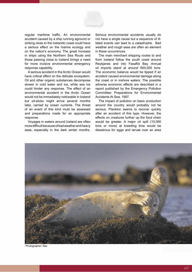
45
regular maritime traffic. An environmental accident caused by a ship running aground or sinking close to the Icelandic coast could have a serious effect on the marine ecology and on the nation's economy. The great increase in ships using the Northern Sea Route and those passing close to Iceland brings a need for more incisive environmental emergency response capability.
A serious accident in the Arctic Ocean would have critical effect on the delicate ecosystem. Oil and other organic substances decompose slower in cold water and ice, while sea ice could hinder any response. The effect of an environmental accident in the Arctic Ocean would not be immediately noticeable in Iceland but oil-slicks might arrive several months later, carried by ocean currents. The threat of an event of this kind must be assessed and preparations made for an appropriate response.
Voyages in waters around Iceland are often more difficult because of bad weather and heavy seas, especially in the dark winter months.
Serious environmental accidents usually do not have a single cause but a sequence of ill-fated events can lead to a catastrophe. Bad weather and rough seas are often an element in these occurrences.
The main merchant shipping routes to and from Iceland follow the south coast around Reykjanes and into Faxaflói Bay. Annual oil imports stand at around 600,000 tons. The economic balance would be tipped if an accident caused environmental damage along the coast or in inshore waters. The possible adverse economic effects are described in a report published by the Emergency Pollution Committee: Preparations for Environmental Accidents At Sea, 1997.
The impact of pollution on basic production around the country would probably not be serious. Plankton seems to recover quickly after an accident of this type. However, the effects on creatures further up the food chain would be greater. A major oil spill (10,000 tons or more) at breeding time would be disastrous for eggs and larvae over an area
Photographer: Rax
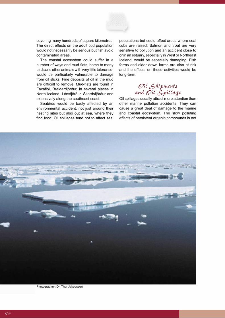
46
covering many hundreds of square kilometres. The direct effects on the adult cod population would not necessarily be serious but fish avoid contaminated areas.
The coastal ecosystem could suffer in a number of ways and mud-flats, home to many birds and other animals with very little tolerance, would be particularly vulnerable to damage from oil slicks. Fine deposits of oil in the mud are difficult to remove. Mud-flats are found in Faxaflói, Breidardjörður, in several places in North Iceland, Lónsfjörður, Skardsfjörður and extensively along the southeast coast.
Seabirds would be badly affected by an environmental accident, not just around their nesting sites but also out at sea, where they find food. Oil spillages tend not to affect seal
populations but could affect areas where seal cubs are raised. Salmon and trout are very sensitive to pollution and an accident close to or in an estuary, especially in West or Northeast Iceland, would be especially damaging. Fish farms and eider down farms are also at risk and the effects on those activities would be long-term.
Oil Shipments and Oil Spillage
Oil spillages usually attract more attention than other marine pollution accidents. They can cause a great deal of damage to the marine and coastal ecosystem. The slow polluting effects of persistent organic compounds is not
Photographer: Dr. Thor Jakobsson
47
as newsworthy but it can be more of a threat to the ecology in the long term.
There are few things that could be more damaging to the marine environment and to the economy of Iceland than an oil spill from a large tanker in Icelandic waters. It is essential to monitor the anticipated growth in oil transport on shipping routes near Iceland as exports from Northwest Russia increase, and introduce preventive measures to reduce the likelihood of accidents.
Exports of oil by tanker from Northwest Russia have increased and according to information provided by the Norwegians, there is on average one 30,000 ton oil tanker sailing along the coast of Norway at any one time. This traffic is expected to increase to three 100,000 ton ships within a few years; most of the oil goes to Holland or the United States. If this is the case then it is likely that there will be two laden and two empty tankers in Icelandic waters at any one time.
Concerns have been raised about oil shipments along the Norwegian coast and measures have been put in place to reduce the danger they bring. Ships carrying oil are subject to strict notification rules. Each ship is closely monitored and powerful tugboats that could assist ships up to 100,000 tons are on standby in North Norway. Regulations are in force allowing for sailing just inside the twelve mile zone but this is likely to be pushed out to 30 miles.
Iceland and Norway have similar vested interests in regulating tanker traffic from Northwest Russia and influencing subsequent developments. It is important to ensure that oil tankers are equipped according to regulations when sailing in these areas. Investigations must be made into the need for special measures to restrict large-scale oil shipments through sensitive areas under Icelandic jurisdiction.
A committee was appointed by the Minister of Communications to ascertain the need for limitations to be placed on shipping around the Southwest coast. The committee presented a report in December 2000 that resulted in a research project into how swell and currents would affect the safety of shipping on new or altered routes further from land than those currently used.
Preparedness for Environmental Emergencies
Port authorities are legally required to respond to marine accidents in their localities while the Environmental Agency, Coast Guard and the Maritime Administration are responsible for offshore areas. Comprehensive pollution control equipment is kept in one port in each region of the country, although many other ports are also equipped. The Environmental Agency also has equipment in its storage facilities.
If an environmental accident occurs on a scale that the authorities are unable to deal with, foreign governments may be asked for assistance in line with the Copenhagen Agreement. Scandinavian countries have agreed to make a joint response in the event of a large environmental accident.
It will almost certainly be necessary to reorganise and extend contingency plans for dealing with potential oil pollution as rapidly increasing numbers of tankers sail close to Iceland. At the same time, consideration must be given to the threat that oil pollution might reach Iceland after an accident in the Barents Sea or Arctic Ocean.
If a large transhipment port is built in Iceland, a thorough revision of pollution control readiness will be required in readiness for the increase in marine traffic.
The indirect effects of environmental accidents must also be taken into account. Press reports of accidents are equally important, even if the actual effect on the environment is not especially serious. The wholesome, unpolluted image of Icelandic seafood products must be protected. A decisive press response to reassure consumers following any ecological mishap is as important as action to limit the spread of the pollution itself.
Nuclear-powered Ships and Shipment
of Nuclear MaterialRussia operates six nuclear-powered ice-breakers and one additional vessel is being built. The ships are based in Murmansk and perform an important role assisting shipping on the Northern Sea Route. Their operation

48
has been fraught with difficulties but oil exports from the Kara Sea have recently revived demand for their services.
An accident involving a nuclear-powered ship could cause marine pollution. It is unlikely that radiation from the site of an accident off North Russia would reach Iceland. Ice-breaking operations take place a long way from this country and currents would carry the radiation further away. Nuclear reactors used in ice-breakers are far smaller than those used in nuclear power stations.
However, nuclear accidents represent a serious environmental hazard. Iceland has objected strongly to the nuclear fuel reprocessing plant in Britain that releases radioactive material into the sea, even though
the radiation is negligible by the time it reaches the middle of the North Atlantic and is well inside the strictest health limits. Other Nordic countries have for many years voiced their objections to nuclear reprocessing in Russia, on the Barents Sea coast and Novaya Zemlya.
The Russian parliament has passed legislation to allow the storage of foreign radioactive waste on Russian territory. A reprocessing facility is planned in Tjeljabinsk, Siberia. Nordic governments and others have voiced their concerns over these plans.
It is vital that Iceland monitors developments in nuclear-powered shipping on the Northern Sea Route and any discussion regarding the transport of nuclear waste by that route or anywhere close to the Icelandic coast.
Fisheries exhibition in the old harbour, Reykjavík. Maintaining Iceland’s image as a producer of wholesome seafoods is vital. Photographer: Haukur Snorrason.
49
Any assessment of the environmental impact of a transhipment port to service the Northern Sea Route would need to assess the effects of both construction work and operation of the port.
Environmental effects depend on location, shipping volume and the types of material transported. Nearby urban or industrial areas also have a significant effect. The level of environmental protection applied must take into account the potentially damaging effects of the construction and operation of the port.
Ecological awareness during the design and organisation of the port facilities would reduce negative international publicity. It is vital to learn from the experiences of other countries, especially those where port construction has been successful. The port of Vancouver, Canada, is a good example. Environmental specialists took part in the design and preparation of the project. It is considered to be one of the cleanest large city ports in the world and seawater from the port is pumped directly into the city's public aquarium. Straumsvík is an example of an Icelandic port where a successfully applied environmental policy has made it possible for salmon to be bred and reared within the port area.
The Environmental Effects of Port Construction
The construction of a transhipment port would require a large area of land and access to gravel
and rock quarries. It is usually necessary to build breakwaters and deepen the port basin and approaches, but this will not be necessary in the projected areas in Iceland, thus reducing negative environmental effects and costs.
In addition to building the port itself, it is necessary to make plans for ancillary services linked to its operation. An existing urban area at the location would preclude the need to build up the entire operation from the ground. Special attention must be paid to the port's oil storage facilities. Rough calculations put the total fuel requirement for container ships at 600,000 tons annually, assuming 2 million TEU transhipment, which is similar to the total current level of imports for the entire country.
Transport systems around the port would need to be improved. Roads would need strengthening and widening so that large container carriers would have easy, all-year access to the ring-road. It would be necessary to improve airport structures to be certain that there are effective international connections suitable for a competitive port. Docks that allow loading and unloading from both sides require extensive excavation.
Large-scale building projects affect wide areas but their environmental effects are variable according to circumstances at the site. Influential factors include whether the site is level or on a slope, whether the ground is loose or bedrock and the level of the water table. Checks must be made in case there are any sensitive areas nearby. Similarly, cultural
The Environmental Impacts of a Transhipment Port in Iceland
It is essential that the location and planning of a transhipment port take into account environmental considerations. A transhipment port requires considerable land and large quantities of material for port structures, residential facilities, transport infrastructure and
for other constructions. Plans must also de drawn up for ancillary services linked to its operation. Although the environment can be affected in many ways, the impacts can be
reduced with targeted countermeasures. Environmental control will be part of the port management structure and needs to be well thought out to protect the environment, build up pollution control and ensure rapid reaction to hazards and accidents. New
environmental legislation has been introduced in Iceland to ensure that environmental considerations are taken into account during port construction.

50
and archaeological sites must be taken into consideration. Suitable quarrying sites must exist close to the port site and they must be filled and tidied up when construction work is completed to prevent water or wind erosion.
A vast quantity of building materials will be needed in the construction of port structures, buildings and roads. Loose mineral materials, sand and gravel are used in construction work both in foundations and in concrete. Sedimentary material is extracted from over 90% of quarries in Iceland, usually from riverbeds, sandbanks and stream terraces. Continuing access to a quarry is also important for maintenance and for new construction work.
Sand, gravel and rock quarries can have a detrimental affect and leave scars on the landscape unless care is taken during extraction and restoration. This applies particularly to off-site quarries. It may be possible to use material taken from the seabed, but tests must be performed to ascertain the ecological effects and to ensure that health and pollution requirements are fulfilled.
Freshwater supplies must be adequate. If there is geothermal energy in the area it may be necessary to drill new boreholes. The port will require a stable electricity supply as well as other services. Ships in port will connect to the onshore electricity supply to reduce fuel consumption and atmospheric pollution.
The Environmental Effects of Transhipment Port OperationsA transhipment port can affect the environment in and around the port in a number of ways. Container ports are less polluting than ports where freight is transferred for immediate overland shipment by road or rail. Port authorities in Los Angeles and Rotterdam have invested large sums in order to reduce atmospheric pollution and traffic congestion resulting from their operations. Container shipments are cleaner and more environmentally friendly than loose material shipments.
Marine Pollution and Disturbance of the Seabed
The most serious threat to the environment in ports comes from oil. Over 80% of all recorded
accidents involving oil are in or close to ports. Although they are often relatively small their effect is cumulative. They often occur during normal port operations like refuelling, when oil accidentally escapes into the sea. Leaking pipes and tanks that are not repaired can lead to more serious pollution. It is also vital to prevent illegal discharges of oil, bilge water and cleaning water. The most serious accidents usually involve tankers.
Oil decomposes slowly around Iceland because of cold seas and darkness during the winter months. It can be lethal for bottom and coastal creatures and affect fish stocks. Some of the persistent organic compounds in oil are carcinogenic and can accumulate in the food chain. Pollutants can be carried to sea by surface water and cleaning water used in ports. Maintenance materials can be ecologically harmful, including paint, solvents, cleansers, bleach, disinfectants, sandblasting material and detergents.
The discharge of bilge water can be highly damaging if allowed. It contains many harmful substances, organisms, plants and bacteria that can be transferred between regions. Foreign organisms from bilge water are considered to be one of the five main threats to the biological diversity of the sea. British researchers have shown that over a third of 50 foreign organisms found along their coast had been introduced in bilge or ballast water.
Very little research has been carried out as regards the effects of sewage from ships in port. Apart from organic waste and bacteria a range of cleaning agents and other substances are used on ships. These include chlorine, ammonia and zinc, all of which can have an adverse environmental effect if they are released into the water in port.
Facilities must be installed to handle waste from ships as strong regulations are in place regarding its discharge at sea. It is especially important to monitor these regulations in northern latitudes although inadequate waste disposal systems in ports encourages illegal discharges.
Natural dispersal of sediment is important for coastal areas. Changes can disrupt natural balances. Port installations that project out into the sea can cause the formation of sand or mud banks. A quick build-up of sediment

51
can cover habitats on the seabed and turbidity can reduce the amount of penetrating light. Reductions in mud or sandbanks elsewhere can negatively affect the natural balance and cause erosion. Sensitive habitats can also be damaged when anchors drag across the seabed.
Atmospheric Pollution, Noise and Visual Pollution
Atmospheric pollution is common in port areas. Container lorries, cranes and other vehicles can cause high levels of pollution as can ships' engines if they are allowed to run in port. There is a danger that polluted air could collect in narrow fjords where mountains and local conditions might prevent circulation unless special measures are applied. Sound pollution in ports is caused mainly by cranes and mechanical equipment used while transferring containers. This machinery is used around the clock in large ports and noise can be damaging to health.
Repairing and maintaining ships can often be noisy as can ships engines as they are being started up. Noise pollution from ships and ports can also disturb birds and fish, scaring them away from the area.
For many, a transhipment port in an Icelandic fjord would be an environmental eyesore. Tall cranes can be seen from long distances if there are no mountains or hills to obscure them. A 150-300 hectare container storage area could
hardly be described as being attractive and nor could oil storage tanks, warehouses and other structures.
Preventive Measures Regarding
Environmental ImpactsThe choice of site for a transhipment port and its design are extremely important. Environmentally acceptable working methods must be used and legislation must be put in place to ensure that the installation meets requirements. An environmental control system must be part of the port's management policy; pollution controls must be installed and a swift response to environmental mishaps must be guaranteed.
The choice of site must take into account natural hazards such as avalanches, rock or mud slides, flooding, tides, subsidence, earthquakes, volcanic eruptions, sea ice and other dangers. The port should preferably be close to an existing urban area and airport to preclude the necessity of building all services from scratch. Care should be taken to keep environmental damage due to quarrying to a minimum and great care should be taken in regard of sites of natural interest, special geological formations, breeding grounds or archaeological relics.
Quarries should preferably be close to the construction site so as to cause minimum disruption when material is transferred. They must be properly excavated and enclosed
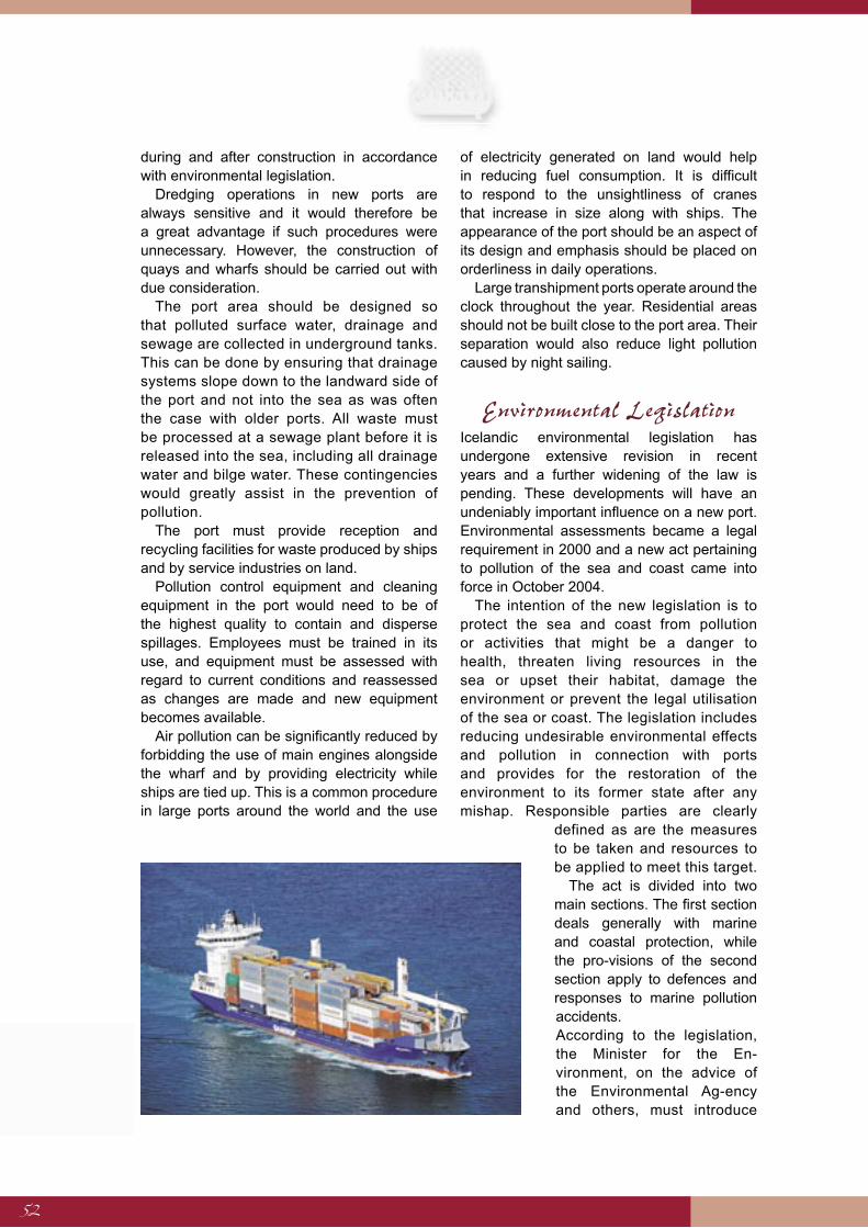
52
during and after construction in accordance with environmental legislation.
Dredging operations in new ports are always sensitive and it would therefore be a great advantage if such procedures were unnecessary. However, the construction of quays and wharfs should be carried out with due consideration.
The port area should be designed so that polluted surface water, drainage and sewage are collected in underground tanks. This can be done by ensuring that drainage systems slope down to the landward side of the port and not into the sea as was often the case with older ports. All waste must be processed at a sewage plant before it is released into the sea, including all drainage water and bilge water. These contingencies would greatly assist in the prevention of pollution.
The port must provide reception and recycling facilities for waste produced by ships and by service industries on land.
Pollution control equipment and cleaning equipment in the port would need to be of the highest quality to contain and disperse spillages. Employees must be trained in its use, and equipment must be assessed with regard to current conditions and reassessed as changes are made and new equipment becomes available.
Air pollution can be significantly reduced by forbidding the use of main engines alongside the wharf and by providing electricity while ships are tied up. This is a common procedure in large ports around the world and the use
of electricity generated on land would help in reducing fuel consumption. It is difficult to respond to the unsightliness of cranes that increase in size along with ships. The appearance of the port should be an aspect of its design and emphasis should be placed on orderliness in daily operations.
Large transhipment ports operate around the clock throughout the year. Residential areas should not be built close to the port area. Their separation would also reduce light pollution caused by night sailing.
Environmental LegislationIcelandic environmental legislation has undergone extensive revision in recent years and a further widening of the law is pending. These developments will have an undeniably important influence on a new port. Environmental assessments became a legal requirement in 2000 and a new act pertaining to pollution of the sea and coast came into force in October 2004.
The intention of the new legislation is to protect the sea and coast from pollution or activities that might be a danger to health, threaten living resources in the sea or upset their habitat, damage the environment or prevent the legal utilisation of the sea or coast. The legislation includes reducing undesirable environmental effects and pollution in connection with ports and provides for the restoration of the environment to its former state after any mishap. Responsible parties are clearly
defined as are the measures to be taken and resources to be applied to meet this target.
The act is divided into two main sections. The first section deals generally with marine and coastal protection, while the pro-visions of the second section apply to defences and responses to marine pollution accidents.According to the legislation, the Minister for the En-vironment, on the advice of the Environmental Ag-ency and others, must introduce
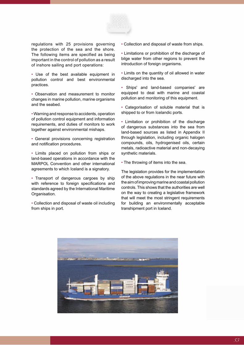
53
regulations with 25 provisions governing the protection of the sea and the shore. The following items are specified as being important in the control of pollution as a result of inshore sailing and port operations:
• Use of the best available equipment in pollution control and best environmental practices.
• Observation and measurement to monitor changes in marine pollution, marine organisms and the seabed.
• Warning and response to accidents, operation of pollution control equipment and information requirements, and duties of monitors to work together against environmental mishaps.
• General provisions concerning registration and notification procedures.
• Limits placed on pollution from ships or land-based operations in accordance with the MARPOL Convention and other international agreements to which Iceland is a signatory.
• Transport of dangerous cargoes by ship with reference to foreign specifications and standards agreed by the International Maritime Organisation.
• Collection and disposal of waste oil including from ships in port.
• Collection and disposal of waste from ships.
• Limitations or prohibition of the discharge of bilge water from other regions to prevent the introduction of foreign organisms.
• Limits on the quantity of oil allowed in water discharged into the sea.
• Ships' and land-based companies' are equipped to deal with marine and coastal pollution and monitoring of this equipment.
• Categorisation of soluble material that is shipped to or from Icelandic ports.
• Limitation or prohibition of the discharge of dangerous substances into the sea from land-based sources as listed in Appendix II through legislation, including organic halogen compounds, oils, hydrogenised oils, certain metals, radioactive material and non-decaying synthetic materials.
• The throwing of items into the sea.
The legislation provides for the implementation of the above regulations in the near future with the aim of improving marine and coastal pollution controls. This shows that the authorities are well on the way to creating a legislative framework that will meet the most stringent requirements for building an environmentally acceptable transhipment port in Iceland.
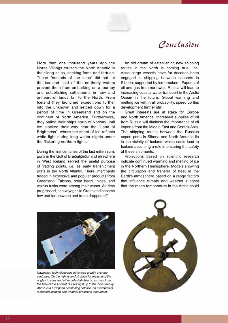
54
More than one thousand years ago the Norse Vikings cruised the North Atlantic in their long ships, seeking fame and fortune. These "nomads of the seas" did not let the ice and cold of the northerly waters prevent them from embarking on a journey and establishing settlements in new and unheard-of lands far to the North. From Iceland they launched expeditions further into the unknown and settled down for a period of time in Greenland and on the continent of North America. Furthermore, they sailed their ships north of Norway until ice blocked their way near the "Land of Brightness", where the sheet of ice reflects white light during long winter nights under the flickering northern lights.
During the first centuries of the last millennium, ports in the Gulf of Breiðafjörður and elsewhere in West Iceland served the useful purpose of trading points, i.e. as early transhipment ports in the North Atlantic. There, merchants traded in expensive and popular products from Greenland. Falcons, polar bears, hides, and walrus tusks were among their wares. As time progressed, sea voyages to Greenland became few and far between and trade dropped off.
An old dream of establishing new shipping routes in the North is coming true. Ice-class cargo vessels have for decades been engaged in shipping between seaports in Siberia, supported by ice-breakers. Exports of oil and gas from northwest Russia will lead to increasing coastal water transport in the Arctic Ocean in the future. Global warming and melting ice will, in all probability, speed up this development further still.
Great interests are at stake for Europe and North America. Increased supplies of oil from Russia will diminish the importance of oil imports from the Middle East and Central Asia. The shipping routes between the Russian export ports in Siberia and North America lie in the vicinity of Iceland, which could lead to Iceland assuming a role in ensuring the safety of these shipments.
Projections based on scientific research indicate continued warming and melting of ice in the Northern Hemisphere. Models showing the circulation and transfer of heat in the Earth's atmosphere based on a range factors that influence climate and weather suggest that the mean temperature in the Arctic could
Conclusion
Navigation technology has advanced greatly over the centuries. On the right is an Astrolobe for measuring the angles to stars and other celestial objects, as used from the time of the Ancient Greeks right up to the 17th century. Above is a European positioning satellite, an examples of a modern location and weather prediction instrument.
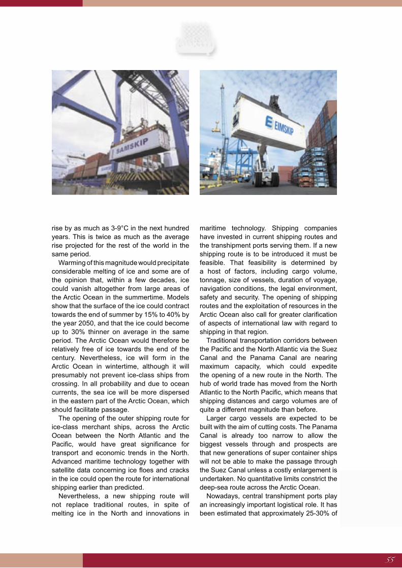
55
rise by as much as 3-9°C in the next hundred years. This is twice as much as the average rise projected for the rest of the world in the same period.
Warming of this magnitude would precipitate considerable melting of ice and some are of the opinion that, within a few decades, ice could vanish altogether from large areas of the Arctic Ocean in the summertime. Models show that the surface of the ice could contract towards the end of summer by 15% to 40% by the year 2050, and that the ice could become up to 30% thinner on average in the same period. The Arctic Ocean would therefore be relatively free of ice towards the end of the century. Nevertheless, ice will form in the Arctic Ocean in wintertime, although it will presumably not prevent ice-class ships from crossing. In all probability and due to ocean currents, the sea ice will be more dispersed in the eastern part of the Arctic Ocean, which should facilitate passage.
The opening of the outer shipping route for ice-class merchant ships, across the Arctic Ocean between the North Atlantic and the Pacific, would have great significance for transport and economic trends in the North. Advanced maritime technology together with satellite data concerning ice floes and cracks in the ice could open the route for international shipping earlier than predicted.
Nevertheless, a new shipping route will not replace traditional routes, in spite of melting ice in the North and innovations in
maritime technology. Shipping companies have invested in current shipping routes and the transhipment ports serving them. If a new shipping route is to be introduced it must be feasible. That feasibility is determined by a host of factors, including cargo volume, tonnage, size of vessels, duration of voyage, navigation conditions, the legal environment, safety and security. The opening of shipping routes and the exploitation of resources in the Arctic Ocean also call for greater clarification of aspects of international law with regard to shipping in that region.
Traditional transportation corridors between the Pacific and the North Atlantic via the Suez Canal and the Panama Canal are nearing maximum capacity, which could expedite the opening of a new route in the North. The hub of world trade has moved from the North Atlantic to the North Pacific, which means that shipping distances and cargo volumes are of quite a different magnitude than before.
Larger cargo vessels are expected to be built with the aim of cutting costs. The Panama Canal is already too narrow to allow the biggest vessels through and prospects are that new generations of super container ships will not be able to make the passage through the Suez Canal unless a costly enlargement is undertaken. No quantitative limits constrict the deep-sea route across the Arctic Ocean.
Nowadays, central transhipment ports play an increasingly important logistical role. It has been estimated that approximately 25-30% of
56
all containers used in international maritime transport were transhipped in 2000, and that percentage is rising sharply. The location of transhipment ports is, together with adequate facilities, vital for their performance and for their establishment as a link in the transportation chain. Essential conditions for a transhipment port are that it is just a short distance from the shipping routes and that it is built on an effective port site.
Iceland, situated in the northern part of the North Atlantic, mid-way between North Europe and the east coast of North America, is ideal for such a port, which could equally serve as a transhipment hub for sea transport across the North Atlantic and the Arctic Ocean passage when it opens. The deep fjords in East Iceland, together with the fjords of Eyjafjörður and Hvalfjörður offer good natural conditions for ports catering for large ships and plenty of land can be found there for container areas. However, the services that Iceland can offer as the location for a transhipment port are of little value unless targeted action is taken to inform international shipping companies and awaken their interest.
The ecosystem of the Arctic is much more vulnerable than more southerly environments. The image of Iceland as a producer of wholesome sea products is no less important to Icelanders than the fishing grounds themselves. The main concern of Icelanders regarding the northeast shipping route is linked to marine pollution emergencies due to accidents rather than regular maritime traffic.
It is essential to prepare for such hazards by introducing adequate measures for prevention and response and by monitoring the anticipated increase in oil transport on shipping routes near Iceland. On the other hand, the shortening of shipping routes between Europe and Asia could reduce fuel combustion and greenhouse gas emissions on a global scale. The energy requirements of the merchant fleet
should preferably be met by using ecologically acceptable energy sources, and Iceland could play a decisive role in the development of more eco-friendly vessels, e.g. by taking part in joint ventures in the fields of hydrogen research and hydrogen applications.
It is essential to choose the location for transhipment ports and plan such ports with care and due regard for environmental requirements. Environmental legislation has developed rapidly in Iceland in the last few years and now expects that full account is taken of conservation requirements in connection with harbour works and port administration.
A transhipment port requires lots of land. Large amounts of material are needed for port constructions, residential facilities, transport infrastructure and for other works. In addition, it is necessary to make plans for ancillary services linked to its operation. Although various environmental impacts can be expected, they can be contained with targeted countermeasures. The same applies to the operation of ports and harbours, where the application of an environmental management scheme is necessary to protect the environment and ensure quick reaction in cases of pollution risk and accidents.
The possible effects of the opening of new shipping routes in the North for Iceland, could be manifold and large-scale. It is impossible to predict those effects with any degree of accuracy. Apart from the fact that communications, the environment and the national economy all enter into the equation, it is necessary to consider unforeseen circumstances that might emerge with respect to Iceland's security and defence as transportation lines for a substantial proportion of the world's commercially valuable cargo will lie close to the coast of Iceland. The present report should be seen as a first step towards a proper assessment of the interests that could be at stake in this new and demanding area for Iceland.

57
Working Group on the Northern Sea Route A working group on the opening of the Northern Sea Route was established on 19 August 2003 on the instructions of the Minister for Foreign Affairs. The chairman of the working group was Gunnar Pálsson, Ambassador and Head of the Department of Natural Resources and Environmental Affairs in the Ministry for Foreign Affairs. Other members of the group were Ragnar Baldursson, Counsellor, Ministry for Foreign Affairs, Hugi Ólafsson, Head of Division, Ministry for the Environment, Dr. Þór Jakobsson, Head of Sea Ice service, Icelandic Meteorological Office, Björn Gunnarsson, Dean of the University of Akureyri, Ragnar Þór Jónsson, Exports Director, Eimskip, Pálmar Magnússon, Vice President of Operations, Samskip, Gestur Ólafsson, Architect and Planner, Skipulags-, arkitekta- og verkfræðistofunni ehf., Sigurbergur Björnsson, Head of Divison, Ministry of Transport and Gísli Viggósson, Director of Research and Development, Icelandic Maritime Administration. The group was also assisted by Rúnar Guðjónsson, from the Ministry of Communications and Magnea Marínósdóttir, an intern.
Scope of the Working GroupThe working group's scope was specified in the terms of reference drawn up by the Ministry for Foreign Affairs. The group divided into two subgroups: a shipping group and an environmental group. These two subgroups met regularly and joint meetings were held monthly. The shipping group concentrated on shipping and harbour issues, while the environmental group directed its attention towards climate, environmental and pollution issues.
Information was gathered concerning Arctic shipping developments and the opening of new routes in the North in the wake of increased exploitation of natural resources in the polar region, climate change and how Icelandic interests could best be ensured in this respect. Emphasis was placed on the Northern Sea Route because of its particular relevance for Iceland, although the Northwest Passage on the Canadian side is also important. Special attention was paid to whether Iceland could be the site of a transhipment port for shipments between the Pacific and North Atlantic via the Northern Sea Route, should it open for merchant vessels. Data was collected relating to ports of this type and suitable locations were assessed. However, the group's report makes no distinction between individual sites as it would then have been necessary to take into consideration circumstances beyond the remit of the working group.
The environmental repercussions of building a transhipment port were assessed along with measures to be taken to deal with environmental
Epilogue
58
accidents and pollution resulting from a large port and increased shipping in Icelandic waters.
The group looked in broad terms at the effect and opportunities in the light of the information to hand and identified parties who might be approached to form a partnership. The group did not contact possible partners, although such a course was within the scope of the group's remit, because the creation of such links could have a significant and wide-reaching relevance in the economic and political arenas. On the other hand, representatives of the Ministry for Foreign Affairs attended international conferences on the development of shipping in the Arctic in order to lay foundations for partnerships that could be beneficial in the future, at the same time gathering information and drawing attention to Icelandic interests.
The working group sought the advice of a number of foreign specialists. A shipping and ports expert from the United States was invited to address the group concerning ways in which Iceland could ensure that it has an important part to play when the Northern Sea Route opens. Additionally, a representative from the World Wildlife Fund's International Arctic Programme attended a meeting to present the organisation's view of the environmental effects of increased shipping in northern waters.

59
The group worked with information in mind from other working groups and international joint projects concerned with shipping in the North. A large number of groups are active in this field as interest in Arctic shipping routes increases. The following projects are in alphabetical order:
ACIA (Arctic Climate Impact Assessment). Scientific report by the Arctic Council that assesses the effects of climate change in the North. A summary based on the report was made available in November 2004. See http:// www.amap.no/acia/
AMTW (Arctic Marine Transport Workshop). Project organised by the Institute of the North, Alaska and a joint group representing the Arctic Council and the Northern Forum, CITF (Circumpolar Infrastructural Task Force), Autumn 2004, to investigate future prospects for shipping in the North Polar region following climate change and innovation in shipping technologies: http://www.institutenorth.org and http://www. iascp.org.
ARCDEV (Arctic Demonstration and Exploratory Voyage). Joint project involving leading companies and research institutes in Western Europe and Russia in the field of ice sailing, shipping management and marine technology, 1998/9. The project investigated the economical viability of exporting oil from the Russian Arctic to the EU all year round: http://arcdev.neste.com.
ARCOP (Arctic Operational Platform) The platform concerns oil and gas exports from the Russian Arctic region to Europe and North America. More than 20 institutions and companies from Russia, Norway, Finland, Germany, Netherlands, Britain and Italy took part in ARCOP, supported by grants from the EU: http://www.arcop.fi.
ICE Routes. This was a collaboration effort of organizations in Britain, Norway, Germany, Finland and Russia in 1997/8. The project was supported by the EU's Fourth Framework Programme. Tests were made of technical equipment to improve safety and costs for shipping in ice in the Barents, Kara, Greenland and Baltic Seas: http://www.cordis.lu/transport/ src/icerouterep.htm.
INSROP (International Northern Sea Route Programme) was an international and interdisciplinary research project concerning the Northern Sea Route from 1993 to 1999, supported by the EU. Its aim was to assess the benefits of the route for international shipping. A total of 450 specialists and scientists from 14 nations took part in the project and its conclusions were published in a book entitled "The 21st
Annex
60
Century - Turning Point for the Northern Sea Route?" http://www.fni.no/insrop.
IRIS (Ice Ridging Information for Decision Making in Shipping Operations) received funding from the EU's Fifth Framework Programme in 1998. The project investigated the use of data relating to ice ridges and the safety of shipping. http://www. hut.fi/Units/Ship/Research/Iris/Public.
NMC (Northern Maritime Corridor) was a Norwegian initiative established under the auspices of the EU in 2000. Its objective was to investigate shipping in the North Atlantic, from the European mainland to the Faeroe Islands, Iceland, Greenland and north along the Norwegian coast to the Barents Sea. http://www.savos.no/nmodesc3.pdf
NSR (Northern Sea Route) is a working group of the Barents Council concerning the Northern Sea Route. It has met since 1993 with the intention of supporting the development of international shipping on the Inner Northern Sea Route. http//:www.beac.st
OMAE (Offshore Mechanics and Arctic Engineering) is an international forum that has met for 24 years to discuss technological innovations that relate to shipping in polar regions. The American Society of Mechanical Engineers, ASME, oversees OMAE. (http://www.ooae.org/index.htm)
PAME (Protection of the Arctic Marine Environment) is a working group under the auspices of the Arctic Council, pursuing issues related to the Arctic Ocean. The group has responsibility for overseeing the Arctic Marine Strategic Plan (AMSP) agreed by the fourth ministerial meeting of the Arctic Council in Reykjavík in November 2004.
61
1 Permits are issued by the Northern Sea Route Administration, which was established in 1972.
2 Rothroc, D.A., Yu, Y. & Maykut, G. A., Thinning of the Arctic Sea ice Cover, Geophysical Research Letters, pp. 3469-3472, 1999
3 All references to container units in this publication are TEU (Twenty foot Equivalent Units) i.e. a container that is twenty feet long and 8' 6" high. Most containers these days are in fact 9' 6" high but the TEU unit volume still refers to the original size. Another unit, the FEU, exists and refers to a container that is, at 40 feet, twice as long.
4 M. Beddow, Matthew Market Analysis: Future Supply and Demand for Liner Services 2003/4, Containerisation International, p. 15, 2004. This publication is the source of information regarding the container shipment levels cited in this report.
5 The 12 most important intercontinental shipping routes are between Asia and the west coast of North America, between Northern Europe and Asia, between the Mediterranean and Asia, between Northern Europe and the east coast of North America, between Europe and the Middle East, between Europe/Mediterranean and Australasia, between Northern Europe and South Africa, between Northern Europe and the east coast of South America, between the east coast of North America and the east coast of South America and finally between Australasia and Asia. Other important routes include those between South America and the Mediterranean, between the west coasts of North and South America, South America to Asia and the Indian subcontinent and from the Middle East to Asia.
6 D. Visser, Europe – Far East Dyna Liners, 13-26 March 2004.
7 Drewry Shipping Consultants 2000 and Department for Transport, Modern Ports: A UK Policy, Chapter 1 (A New Ports Policy).
8 Modern Ports: A United Kingdom Policy, Chapter 1, 2000.
9 http://www.orkneycontainer.com
10 http://www.scotland.gov.uk/pages/news/2003/08/SETD036.aspx and Highlands and Islands Enterprise website,
11 http://www.hie.co.uk/default.asp.LocID-hiegrb002004002.htm
References

62
Arctic Pilot, Volume 1, 7th edition, Hydrographer of the Navy, England, 1985.
Baird, Alfred J., The Economics of Container Transhipment in the Orkney Islands, Kirk-wall, Orkney, Orkney Island Council, 2002.
Beddow, Matthew, Market Analysis, Future Supply and Demand for Liner Services 2003/4, Containerisation International, Lon-don, 2004.
Big Oil Playground, Russian Bear Preserve or European Periphery, The Russian Barents Sea Region Towards 2015, B. Brunstad, E. Magnus, P. Swanson, G. Hönneland, I. Överland, Eburon Delft, 2004.
Björn Þorsteinsson, Tíu þorskastríð 1415- 1976, Sögufélagið 1976
Clash, James M., Polar Bear Club, Forbes, New York, 2 April 2001.
Drewry Shipping Consultants, 2000.
Focus on Ports: A Sectoral Overview, Department of Transport, UK, 2000 See report: http://www.dft.gov.uk/stellent/groups/dft_ transstats/documents/page/dft_transstats_ 505687.hcsp.
Hafréttarsamningur Sameinuðu þjóðanna, utanríkisráðuneytið, Reykjavík, 1985.
Hale, David and Hale, Lyric Hughes, China Takes Off, Foreign Affairs November/ December 2003, The Council on Foreign Relations, New York, 2003.
Johannessen, O.M. and M. W. Miles (2000) Arctic Sea Ice and Climate Change – Will the ice disappear in this century? Science Progress, 83(3), pp. 209-222.
Jón Jóhannesson, Íslendingasaga, Almenna bókafélagið 1956.
Helgi Guðmundsson, Um haf innan, Háskóla-útgáfan 1997.
Modern Ports: A United Kingdom Policy, UK Department of Transport, November 2000. See report: http://www.dft.gov.uk/stellent/
groups/dft_shipping/documents/page/dft_ shipping_505279.hcsp
Námur, efnistaka og frágangur, Embætti veiðimálastjóra, Hafrannsóknarstofnun, Iðnaðarráðuneytið, Landgræðsla ríkisins, Landsvirkjun, Náttúruvernd ríkisins, Samband íslenskra sveitarfélaga, Siglingastofnun Íslands, Umhverfisráðuneytið, Vegagerðin, Veiðimálastofnun, Reykjavík, 2002. (Regulations relating to mining and quarrying – various governmental departments and administrative bodies.)
Ostreng, Willy, The Changing Mode of Arctic Politics, From Confrontation to Cooperation, Structural Change in Europe 3 – Innovative City and Business Regions, January 2004, Lou Hagbarth Publications, Germany, 2004.
Ostreng, Willy, Looking Ahead to the Northern Sea Route, Scandinavian Review, Volume 90, No. 2, Autumn 2002, New York.
Ragner, Claes Lykke (ed.), The 21st Century – Turning Point for the Northern Sea Route? Kluwer Academic Publishers, Hollandi, 2000.
Serreze, M.C., Maslanik, J.A., Scambos, T.A., Fetterer, F., Stroeve, J., Knowles, K., Fowler, C., Drobot, S., Barry, R.G. and Haran, T.M., A Record Minimum Arctic Sea Ice Extent and Area in 2002, Geophysical Research Letters, Volume 30, No. 3, 2003.
Rothroc, D.A., Yu, Y. & Maykut, G. A., Thinning of the Arctic Sea-Ice Cover, Geophysical Research Letters, Volume 26, 1999.
Skýrsla bráðamengunarnefndar 1997. Viðbúnaður við bráðum mengunaróhöppum á sjó.
D. Visser, Europe – Far East Dyna Liners, 13-26 March 2004.
Þorvaldur Thoroddssen, Landfræðisaga Íslands, Hið íslenska bókmenntafélag, 1896, Volume II.
Other Sources

63
The Viking Ship Sólfar, by Jón Gunnar Árnason Photographer: Gestur Ólafsson

64