Embed Size (px)
Citation preview
Part of this route crosses open access land on a managed grouse moor, over which
DOGS ARE NOT ALLOWED. This area is coloured red on the accompanying map.
Access may be further restricted during the nesting season and at other times of the year.
To avoid disappointment, please visit www.countrysideaccess.gov.uk
to get the latest restriction information, before you set out.
Begin from the village car park at the
eastern end of the attractive, wide, tree-lined green. Pass into the street and turn
right, following the road round by Old
Dufton Hall farmhouse and enter the lane to
the left of the chapel, signposted ‘Pennine
Way to Garrigill 15 mls’.
Follow the walled lane, and as the wall ends
on the left be guided by the Pennine Way
sign and hand-gate into a confined flagged
gillside path. This leads by further hand-gates
into a farm-access lane leading to (and
through) the gated yard of Coatsike.
Hurning Lane follows naturally on offering
fine views of Dufton Pike, with further gates
and stiles to approach and pass Halsteads, a
traditional farmstead now used for stock-
handling. This is the last hint of settlement
on the walk until Hartside Café.
From the gate beside the buildings the
Pennine Way leads up the open track,
flanked by a remnant hedge. The track
curves downhill to arrive at a wall-stile and
gate, promptly step over the clapper-bridge
spanning Great Rundale Beck. Follow on
with the wallside track, gradually rising to a
kissing-gate, the upper walled lane portion
used for stock handling, hence the mud and
need for the flagstones!
The track continues, and fording Small Burn,
becomes a pleasant green way. Watch to
take the left fork at the Pennine Way
signpost directing along the green path, with
a fine view of Knock Pike, to cross a wall-
stile. An unsuspected bank of heather flanks
the path which leads on with a fence left
above the wide stony debris of Swindale
Beck to another wall-stile and crosses the
broad bridge spanning the valley beck.
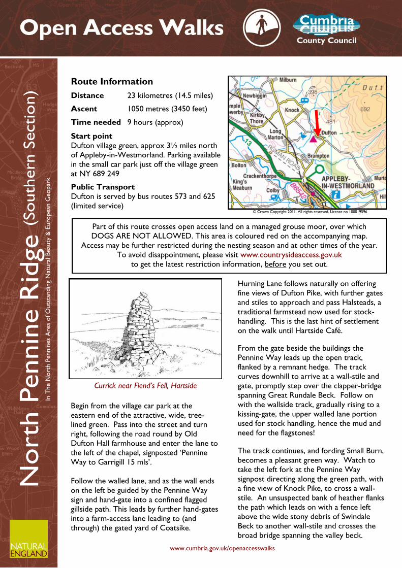
Route Information
Distance 23 kilometres (14.5 miles)
Ascent 1050 metres (3450 feet)
Time needed 9 hours (approx)
Start point
Dufton village green, approx 3½ miles north
of Appleby-in-Westmorland. Parking available
in the small car park just off the village green
at NY 689 249
Public Transport
Dufton is served by bus routes 573 and 625
(limited service)
Nort
h P
ennin
e R
idge (
South
ern
Sectio
n)
Currick near Fiend’s Fell, Hartside
www.cumbria.gov.uk/openaccesswalks
In T
he N
ort
h P
ennin
es
Are
a of O
uts
tandin
g N
atura
l B
eau
ty &
Euro
pean
Geopar
k
© Crown Copyright 2011. All rights reserved. Licence no 100019596
The primary ascent of the Pennine scarp begins
from the Moor House-Upper Teesdale NNR notice
board. This draws attention to the fact that this
extensive (88sq km) area of peat upland habitat is a
leading resource in the study of climate change.
The higher parts cradling arctic alpine plants that
have survived here since the last Ice Age.
Bear up the slope on a tangible path keeping to the
brow above the deeply incised cleft of Swindale
Beck. The path passes a pair of casual cairns from
where there is the first clear view towards Cross
Fell, with Knock Pike below overtopped by the
steam from the British Gypsum works at Kirkby
Thore.
The path marches purposefully up the slope passing
a cairn amid a loose clitter of stones soon following
the western edge of Knock Hush. To all intents a
natural ravine, but this was once enlarged by a
sudden discharge from an artificial dam, the rush of
water better revealing mineral veins - the meaning
of the mining term hush.
Stones with golden trail-blazing arrows ensure the
Pennine Way is never in doubt all the way up to
Knock Old Man. The solid square structure is a
striking landmark, marking the boundary of the
Knock and Dufton parishes and constructed in the
mid 19th century.
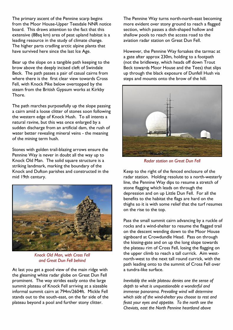
At last you get a good view of the main ridge with
the gleaming white radar globe on Great Dun Fell
prominent. The way strides easily onto the large
summit plateau of Knock Fell arriving at a sizeable
informal summit cairn at 794m/2604ft. Mickle Fell
stands out to the south-east, on the far side of the
plateau beyond a pool and further stony clitter.
The Pennine Way turns north-north-east becoming
more evident over stony ground to reach a flagged
section, which passes a dish-shaped hollow and
shallow pools to reach the access road to the
aviation radar station on Great Dun Fell.
However, the Pennine Way forsakes the tarmac at
a gate after approx 230m, holding to a footpath
(not the bridleway, which heads off down Trout
Beck towards Moor House and the Tees) that slips
up through the black exposure of Dunfell Hush via
steps and mounts onto the brow of the hill.
Keep to the right of the fenced enclosure of the
radar station. Holding resolute to a north-westerly
line, the Pennine Way dips to resume a stretch of
stone flagging which leads on through the
depression and on up Little Dun Fell. For all the
benefits to the habitat the flags are hard on the
thighs so it is with some relief that the turf resumes
on the rise to the top.
Pass the small summit cairn advancing by a ruckle of
rocks and a wind-shelter to resume the flagged trail
on the descent wending down to the Moor House
signboard at Crowdundle Head. Pass on through
the kissing-gate and on up the long slope towards
the plateau rim of Cross Fell, losing the flagging on
the upper climb to reach a tall currick. Aim west-
north-west to the next tall round currick, with the path leading onto to the summit of Cross Fell over
a tundra-like surface.
Inevitably the wide plateau denies one the sense of
depth to what is unquestionable a wonderful and
immense panorama. Prevailing wind will determine
which side of the wind-shelter you choose to rest and
feast your eyes and appetite. To the north see the
Cheviots, east the North Pennine heartland above
Knock Old Man, with Cross Fell
and Great Dun Fell behind
Radar station on Great Dun Fell
Weardale, south the ‘golf ball’ on Great Dun Fell backed
by Mickle Fell seem far flung details, and west, oh yes
west, across the Eden vale the stirring ranks of the
Lakeland Fells with the Helvellyn range and Blencathra
quickly identified.
Frequently cloud hangs over the summit making your
stay a dull one in terms of lighting. If you feel you have
enough time to parade around the western edge of the
scarp, this is recommended to get a fuller appreciation
of the remarkable Eden landscape. Is there any wonder
Biblical writers chose this valley to explain the perfect
origins of man!
The ridge path heads off north-west, guided by curricks, slipping down the damp northern scarp to
meet the old bridleway linking Kirkland with
Garrigill at a large cairn. Bear left and veer off the
regular way onto a quad track after some 200m
north-westwards - a quite consistent line to follow
to Melmerby Fell (Knapside Hill) - onto the
continuing broad watershed ridge.
Passing a cairn, the track leads over grass down to a
compound sheepfold and nook wind-break built
among a substantial surface outcropping of grey
rock. The quad track departs from the ridge and is
of no further relevance. The pathless ridge
continues via a tall currick with rashes of clitter
stones, peaty ground and some exposed groughs, to
pass a couple more curricks before Green Hill, a
low scarp of grey rock with cairns and a length of
wall.
Descend the bank to find a circular sheepfold and
bear left (west) with a quad track to reach a line of
tall curricks. Bear north-west again continuing
through a stony hollow and along the pathless ridge
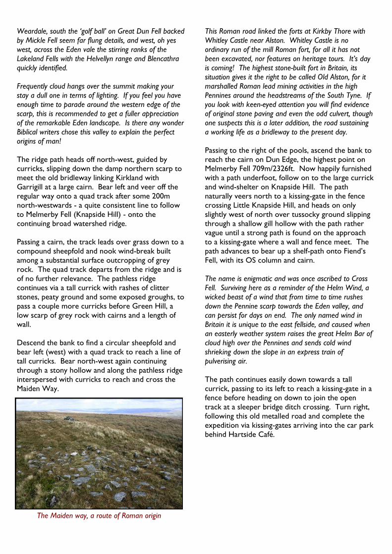
interspersed with curricks to reach and cross the
Maiden Way.
This Roman road linked the forts at Kirkby Thore with
Whitley Castle near Alston. Whitley Castle is no
ordinary run of the mill Roman fort, for all it has not
been excavated, nor features on heritage tours. It’s day
is coming! The highest stone-built fort in Britain, its
situation gives it the right to be called Old Alston, for it
marshalled Roman lead mining activities in the high
Pennines around the headstreams of the South Tyne. If
you look with keen-eyed attention you will find evidence
of original stone paving and even the odd culvert, though
one suspects this is a later addition, the road sustaining
a working life as a bridleway to the present day.
Passing to the right of the pools, ascend the bank to
reach the cairn on Dun Edge, the highest point on Melmerby Fell 709m/2326ft. Now happily furnished
with a path underfoot, follow on to the large currick
and wind-shelter on Knapside Hill. The path
naturally veers north to a kissing-gate in the fence
crossing Little Knapside Hill, and heads on only
slightly west of north over tussocky ground slipping
through a shallow gill hollow with the path rather
vague until a strong path is found on the approach
to a kissing-gate where a wall and fence meet. The
path advances to bear up a shelf-path onto Fiend’s
Fell, with its OS column and cairn.
The name is enigmatic and was once ascribed to Cross
Fell. Surviving here as a reminder of the Helm Wind, a
wicked beast of a wind that from time to time rushes
down the Pennine scarp towards the Eden valley, and
can persist for days on end. The only named wind in
Britain it is unique to the east fellside, and caused when
an easterly weather system raises the great Helm Bar of
cloud high over the Pennines and sends cold wind
shrieking down the slope in an express train of
pulverising air.
The path continues easily down towards a tall
currick, passing to its left to reach a kissing-gate in a
fence before heading on down to join the open
track at a sleeper bridge ditch crossing. Turn right,
following this old metalled road and complete the
expedition via kissing-gates arriving into the car park
behind Hartside Café.
The Maiden way, a route of Roman origin
Leave the large car park at the southern end, via
successive kissing-gates, following the hardcore
track. March westward watching for the sleeper
bridge and waymark post on the left. These guide
the ridge walk off the track and up the slope on a
narrow trod to a kissing-gate in a fence. The path
quickly coming to a tall currick, from where a quad-
track leads on south to the OS column on Fiend’s
Fell (634m/2080ft).
Pass on by the shelter cairn to descend west by a
curious stone-edged green-way. This ends as
mysteriously as it began with the path swinging
south to head for a kissing-gate where a fence and
wall meet. Beyond, a clear path carries on aiming to a cairn after which the path fades as you descend
towards the headstream of Limekiln Beck. Take
advantage of the lateral grass path running parallel
with the hollow (west), beneath the brow just
crossed.
After some 80m watch for the feeder groughs on
the far bank and cross the hollow to their right. A
path of sorts becomes apparent which veers half-
right to avoid the tough moor vegetation, aiming for
a stand alone wooden gateway (lost fence) with
timber shooting butts well in evidence beyond.
A path now remains consistent all the way up the
ridge to go through a kissing-gate in a fence on Little
Knapside Hill.
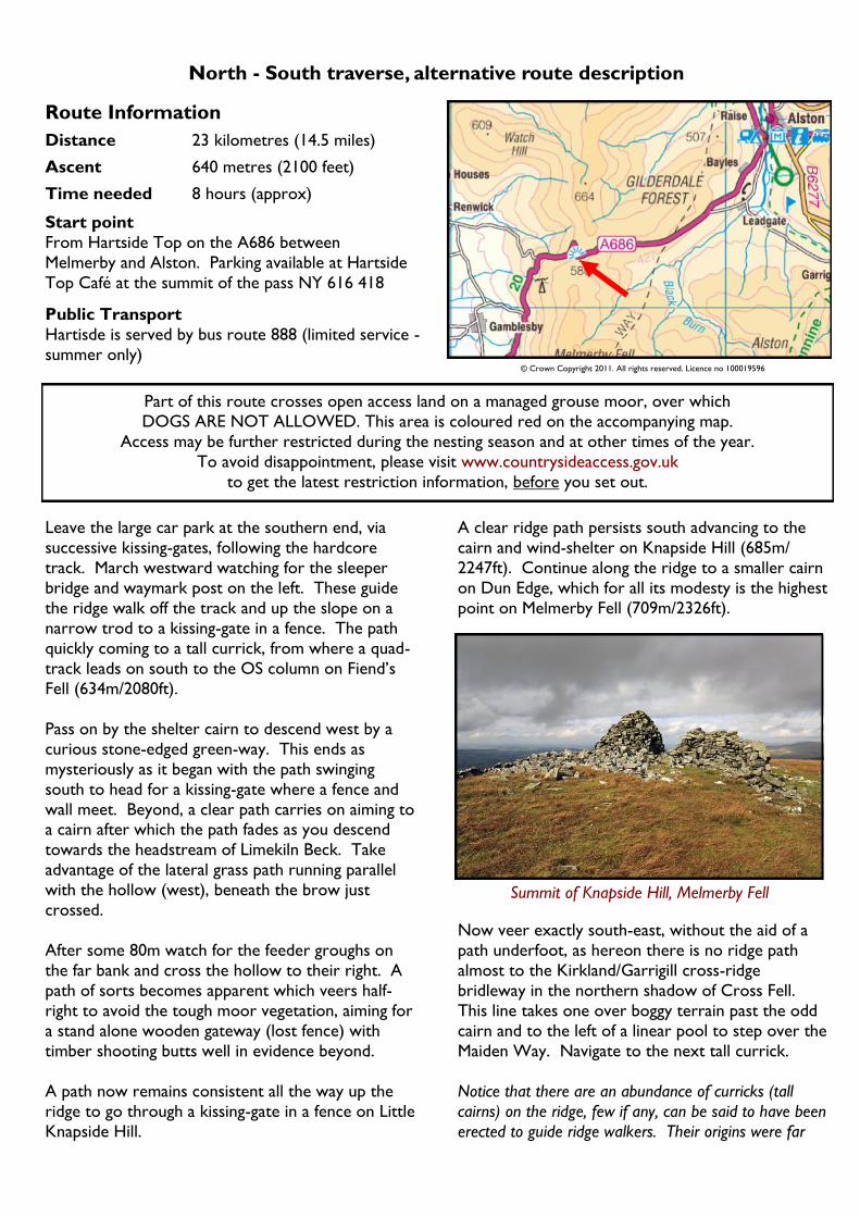
A clear ridge path persists south advancing to the
cairn and wind-shelter on Knapside Hill (685m/
2247ft). Continue along the ridge to a smaller cairn
on Dun Edge, which for all its modesty is the highest
point on Melmerby Fell (709m/2326ft).
Now veer exactly south-east, without the aid of a
path underfoot, as hereon there is no ridge path
almost to the Kirkland/Garrigill cross-ridge
bridleway in the northern shadow of Cross Fell.
This line takes one over boggy terrain past the odd
cairn and to the left of a linear pool to step over the
Maiden Way. Navigate to the next tall currick.
Notice that there are an abundance of curricks (tall
cairns) on the ridge, few if any, can be said to have been
erected to guide ridge walkers. Their origins were far
Part of this route crosses open access land on a managed grouse moor, over which
DOGS ARE NOT ALLOWED. This area is coloured red on the accompanying map.
Access may be further restricted during the nesting season and at other times of the year.
To avoid disappointment, please visit www.countrysideaccess.gov.uk
to get the latest restriction information, before you set out.
Route Information
Distance 23 kilometres (14.5 miles)
Ascent 640 metres (2100 feet)
Time needed 8 hours (approx)
Start point
From Hartside Top on the A686 between
Melmerby and Alston. Parking available at Hartside
Top Café at the summit of the pass NY 616 418
Public Transport
Hartisde is served by bus route 888 (limited service -
summer only)
North - South traverse, alternative route description
© Crown Copyright 2011. All rights reserved. Licence no 100019596
Summit of Knapside Hill, Melmerby Fell
more to do with the working life of shepherds and their
need to navigate across the plateau. Nonetheless, the
irregular sequence of curricks are useful, and as many
are beautifully constructed one is naturally inclined to
pay them an admiring visit.
En route, pass what looks like a shooting butt wall,
but unlikely in this situation and there are patches of
limestone clitter to weave through too. Further
along one comes to a staggered trio of curricks set
on a great stony patch reached through a slack
(hollow). Bear left with the quad track which leads
by a currick in a pool and round to a circular
sheepfold.
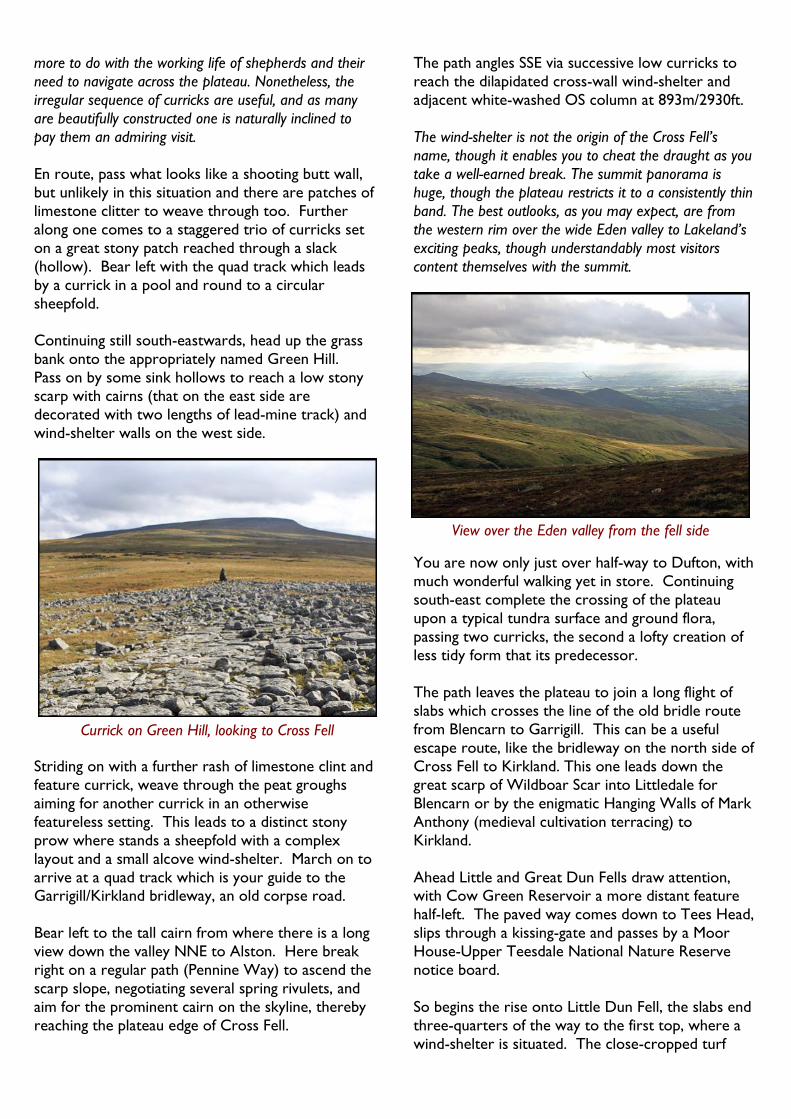
Continuing still south-eastwards, head up the grass
bank onto the appropriately named Green Hill.
Pass on by some sink hollows to reach a low stony
scarp with cairns (that on the east side are
decorated with two lengths of lead-mine track) and
wind-shelter walls on the west side.
Striding on with a further rash of limestone clint and
feature currick, weave through the peat groughs
aiming for another currick in an otherwise
featureless setting. This leads to a distinct stony
prow where stands a sheepfold with a complex
layout and a small alcove wind-shelter. March on to
arrive at a quad track which is your guide to the Garrigill/Kirkland bridleway, an old corpse road.
Bear left to the tall cairn from where there is a long
view down the valley NNE to Alston. Here break
right on a regular path (Pennine Way) to ascend the
scarp slope, negotiating several spring rivulets, and
aim for the prominent cairn on the skyline, thereby
reaching the plateau edge of Cross Fell.
The path angles SSE via successive low curricks to
reach the dilapidated cross-wall wind-shelter and
adjacent white-washed OS column at 893m/2930ft.
The wind-shelter is not the origin of the Cross Fell’s
name, though it enables you to cheat the draught as you
take a well-earned break. The summit panorama is
huge, though the plateau restricts it to a consistently thin
band. The best outlooks, as you may expect, are from
the western rim over the wide Eden valley to Lakeland’s
exciting peaks, though understandably most visitors
content themselves with the summit.
You are now only just over half-way to Dufton, with
much wonderful walking yet in store. Continuing
south-east complete the crossing of the plateau
upon a typical tundra surface and ground flora,
passing two curricks, the second a lofty creation of
less tidy form that its predecessor.
The path leaves the plateau to join a long flight of
slabs which crosses the line of the old bridle route
from Blencarn to Garrigill. This can be a useful
escape route, like the bridleway on the north side of
Cross Fell to Kirkland. This one leads down the
great scarp of Wildboar Scar into Littledale for
Blencarn or by the enigmatic Hanging Walls of Mark
Anthony (medieval cultivation terracing) to
Kirkland.
Ahead Little and Great Dun Fells draw attention, with Cow Green Reservoir a more distant feature
half-left. The paved way comes down to Tees Head,
slips through a kissing-gate and passes by a Moor
House-Upper Teesdale National Nature Reserve
notice board.
So begins the rise onto Little Dun Fell, the slabs end
three-quarters of the way to the first top, where a
wind-shelter is situated. The close-cropped turf
Currick on Green Hill, looking to Cross Fell
View over the Eden valley from the fell side
Words and pictures © Mark Richards 2011
continues towards the modest summit cairn
(842m/2762ft). A fenced area on the east slope
allowing natural herbage to flourish exempt from
sheep’s teeth. The fell-name a simple description of
its dull brown surface colouring.
Descend into the next depression where yet more
slabs are laid to concentrate walker’s passage. The
path is ushered over the left-hand shoulder of the
fell, the summit requisitioned by the NATS radar
station with its distinctive white sphere, twin white
pegs, clad building and sundry other structures and
masts.
The path heads straight on moving down to cross Dunfell Hush. The black shale was exposed by
prospecting lead miners channelling water to reveal
the near-surface mineral deposits. The path leads
on to join the access road from the radar station at
a hand-gate, and sign ‘Dufton 5½ miles’. Follow this
to the right-hand bend here take heed of the
‘Pennine Way Dufton’ sign. The path heads past
two further fenced enclosures and along a paved
section beside sheets of water.
The paving leads on by a shelter cairn to traverse
the flat plateau of Knock Fell to its summit currick
(794m/2604ft) from where one gets the best view
of Mickle Fell (788m/2585ft). Until 1972 this was
the highest point in Yorkshire, since when it upholds the same status in County Durham.
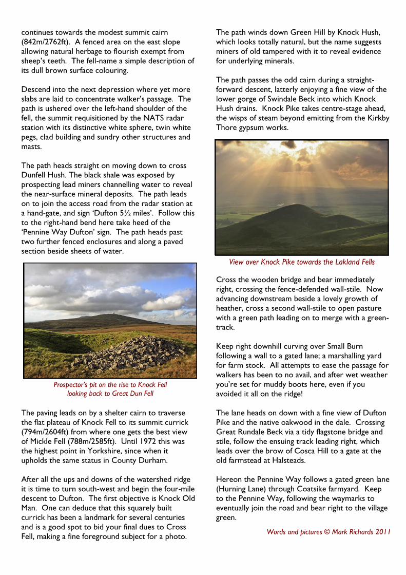
After all the ups and downs of the watershed ridge
it is time to turn south-west and begin the four-mile
descent to Dufton. The first objective is Knock Old
Man. One can deduce that this squarely built
currick has been a landmark for several centuries
and is a good spot to bid your final dues to Cross
Fell, making a fine foreground subject for a photo.
The path winds down Green Hill by Knock Hush,
which looks totally natural, but the name suggests
miners of old tampered with it to reveal evidence
for underlying minerals.
The path passes the odd cairn during a straight-
forward descent, latterly enjoying a fine view of the
lower gorge of Swindale Beck into which Knock
Hush drains. Knock Pike takes centre-stage ahead,
the wisps of steam beyond emitting from the Kirkby
Thore gypsum works.
Cross the wooden bridge and bear immediately
right, crossing the fence-defended wall-stile. Now
advancing downstream beside a lovely growth of
heather, cross a second wall-stile to open pasture
with a green path leading on to merge with a green-
track.
Keep right downhill curving over Small Burn
following a wall to a gated lane; a marshalling yard
for farm stock. All attempts to ease the passage for
walkers has been to no avail, and after wet weather
you’re set for muddy boots here, even if you
avoided it all on the ridge!
The lane heads on down with a fine view of Dufton
Pike and the native oakwood in the dale. Crossing
Great Rundale Beck via a tidy flagstone bridge and
stile, follow the ensuing track leading right, which
leads over the brow of Cosca Hill to a gate at the old farmstead at Halsteads.
Hereon the Pennine Way follows a gated green lane
(Hurning Lane) through Coatsike farmyard. Keep
to the Pennine Way, following the waymarks to
eventually join the road and bear right to the village
green.
Prospector’s pit on the rise to Knock Fell
looking back to Great Dun Fell
View over Knock Pike towards the Lakland Fells

Access Information Restricted Access Line of Route Access Land
This
pro
duct
co
nta
ins
map
pin
g dat
a lic
ense
d fro
m O
rdnan
ce S
urv
ey
©
Cro
wn C
opyr
ight
2011 L
icen
ce n
o 1
00019596
Parking Place
Southern Section
Continued on
Northern Section Map
Northern Section
Continued on
Southern Section Map