Embed Size (px)
Citation preview
TR_003.doc
Technical Report TR_003
Technical report produced for
Strategic Environmental Assessment – SEA2
NORTH SEA FISH AND FISHERIES
Written by CEFAS
Data supplied by FRS
August 2001
© Crown copyright

Strategic Environmental Assessment - SEA2
Technical Report 003 - Fish & Fisheries
August 2001 1 Technical Report
TR_003.doc
NORTH SEA FISH AND FISHERIES
Written by Stuart Rogers, Richard StocksCEFAS
Data from Andrew NewtonFisheries Research Services
CONTENTS
EXECUTIVE SUMMARY.......................................................................................................3
1. INTRODUCTION............................................................................................................8
2. THE IMPACT OF HUMAN ACTIVITY ON NORTH SEA FISH ANDFISHERIES ....................................................................................................................8
3. FISH RESOURCES .......................................................................................................9
3.1 Sources of information and data quality ..................................................................9
3.2 Fish and shellfish populations of the North Sea.....................................................10
3.2.1 Whiting ......................................................................................................10
3.2.2 Cod............................................................................................................11
3.2.3 Haddock ....................................................................................................11
3.2.4 Saithe ........................................................................................................12
3.2.5 Norway pout ..............................................................................................12
3.2.6 Plaice.........................................................................................................13
3.2.7 Sole ...........................................................................................................13
3.2.8 Lemon sole ................................................................................................14
3.2.9 Monkfish ....................................................................................................14
3.2.10 Herring.......................................................................................................15
3.2.11 Sandeel .....................................................................................................15
3.2.12 Mackerel ....................................................................................................16
3.2.13 Sprat..........................................................................................................17
3.2.14 Shrimp .......................................................................................................17
3.2.15 Norway lobster (Nephrops norvegicus) .....................................................17
3.2.16 Edible crab.................................................................................................17
3.2.17 Scallop (Pecten maximus) .........................................................................18
3.3 Spawning seasons of the main commercially exploited stocks..............................18
Strategic Environmental Assessment - SEA2
Technical Report 003 - Fish & Fisheries
Technical Report 2 August 2001
TR_003.doc
3.4 Fish species conservation issues ..........................................................................19
3.4.1 Species and legislation ..............................................................................19
3.4.2 Implications for SEA2 ................................................................................20
3.5 Data quality in relation to fish distribution and life-history ......................................21
4. THE IMPACT OF HUMAN ACTIVITY ON FISH POPULATIONS .................................22
4.1 Major North Sea fisheries......................................................................................22
4.1.1 Mixed demersal fisheries ...........................................................................23
4.1.2 Saithe ........................................................................................................25
4.1.3 Plaice and sole ..........................................................................................25
4.1.4 Herring and mackerel fisheries ..................................................................25
4.1.5 Industrial fisheries......................................................................................26
4.1.6 Crustacean fisheries ..................................................................................26
4.2 The implications of Fisheries Management Measures for the offshore oil and gasindustry....................................................................................................................27
4.2.1 The North Sea mixed demersal trawl fishery .............................................27
4.2.2 The North Sea beam trawl fishery..............................................................28
4.2.3 Industrial fisheries......................................................................................29
4.2.4 Conclusion.................................................................................................29
4.3 The impact of offshore oil and gas exploration ......................................................30
4.3.1 Seismic activity ..........................................................................................31
4.3.2 Cuttings disposal .......................................................................................32
4.3.3 Hydrocarbon spill .......................................................................................33
4.3.4 Safety zones at surface installations and subsea structures ......................34
4.3.5 Obstruction caused by well heads and pipelines........................................34
4.3.6 Conclusion.................................................................................................35
5. ASSESSMENT AND CONCLUSIONS .........................................................................35
5.1 Interaction between the offshore oil and gas industry and fish and fisheries .........35
6. REFERENCES.............................................................................................................37
Strategic Environmental Assessment - SEA2
Technical Report 003 - Fish & Fisheries
August 2001 3 Technical Report
TR_003.doc
EXECUTIVE SUMMARY
The DTI intends to complete a series of sectoral Strategic Environmental Assessments(SEA) to assess the potential impact of the offshore oil and gas licensing rounds, and topromote the environmentally sound development of Britain's hydrocarbon resources. Thefirst of such SEAs was of the area to the north and west of Shetland known as the ‘WhiteZone’. This report is a contribution to SEA2, which includes the mature oil and gas fields ofthe Southern, Central and Northern North Sea, and describes issues related to fish andfisheries. The information provided as part of this process will be used to describeenvironmental sensitivities in the region, and may be used to impose conditions on somelicences.
The recent OSPAR Quality Status Report of the North Sea identified several priority humanactivities which have greatest impact on the marine environment, and these included thedirect and indirect effects of fishing, the input of oil and PAHs by the offshore oil and gasindustry, and the input of nutrients and trace organic contaminants from land. This reporthas focussed on the implications for fish and fisheries of continued exploration andproduction of oil and gas. Of course, there are several other human activities in the NorthSea which also impact fish and fisheries, and foremost amongst these is the effect ofcommercial exploitation itself. This report has restricted discussion of the impact on fishpopulations to these two industries.
The report describes the fish resources of the region (i.e. spawning grounds, nurseryareas), and also the intensity and distribution of commercial fishing activity. It describesthose fisheries management measures which recommend seasonal closures of parts of theNorth Sea to protect spawning or juvenile fish, and regions where these may haveconsequences for oil and gas exploration and production. The report also summarises themost important consequences of oil and gas exploration for fish populations and commercialfisheries, such as the use of seismic surveys and the placement of structures on the seabed.
Most of the commercially important fish species spawn in the spring, between January andJune, although sandeel and herring are exceptions which spawn outside this period.Shrimp, edible crab and lobster tend to be winter spawners, but the period of egg broodingis protracted. Spawning areas and nursery grounds for most fish species are dynamicfeatures of life history and are rarely fixed in one location from year to year. Thus, whilesome species have similar patterns of distribution from one year to the next, others showgreater variability. The combined distribution of spring-spawning fish species showed thatmuch of the northern SEA2 region supports spawning activity of three or more of thesespecies, while in the central region spawning activity is more sporadic, and some areas havelow sensitivity (Fig. 3.3.3). In the southern SEA2 region the greatest spawning activityoccurs in coastal waters and in the most easterly part.
There are several fish species of conservation importance in the North Sea, howeverrelatively few are found in the offshore waters of the North Sea, and may thus be consideredvulnerable to human activity in this region. The European sturgeon is rare and at itsnortherly limit in the North Sea. The basking shark, tope and porbeagle are likely to occur insmall numbers throughout the North Sea, and the common skate occurs at low densitythroughout the northern North Sea, but is very rare in the southern North Sea.
Strategic Environmental Assessment - SEA2
Technical Report 003 - Fish & Fisheries
Technical Report 4 August 2001
TR_003.doc
Descriptions of major North Sea fisheries were prepared from official landing statistics,anecdotal information from local ports, and over-flight surveillance data. Official landingstatistics of the major species by ICES rectangle are available for UK fleets, but only for codand sandeel are international landings by rectangle available.
The North Sea is one of the world's most important fishing grounds. Major UK andinternational fishing fleets operate in the southern, central and northern North Sea andtarget both pelagic and demersal fish stocks. One of the most important fisheries in theNorth Sea is the mixed demersal fishery that targets cod, haddock and whiting in the centraland northern parts of the region. Otter trawl and seine net vessels catch cod as part of amixed fishery in which haddock and whiting form an important component of the catch. Ottertrawling accounted for most of the fishing effort in the northern North Sea, where beamtrawls are rarely used, but in central and southern SEA2 regions otter trawls are lesscommon. Most effort was confined to the northeast coast of the UK, northeast of Scotlandand east of the Shetland Islands. Parts of the Norwegian Deep and the central North Seawere relatively lightly fished. Recent overflight data shows that most otter trawl effort wasconcentrated to the north and west of the Orkney and Shetland Islands throughout the year,near the Fladen Ground and the northeast coast of England in the 1st and 4th quarters of theyear, and during the spring and summer months further offshore near the Dogger Bank andthe Silver Pit.
North Sea plaice and sole are taken in a mixed flatfish fishery by mainly Dutch and UKregistered beam trawlers in the southern and southeastern North Sea. There are alsodirected fisheries for plaice carried out with seine and gill nets and by beam trawlers in thecentral North Sea. The distribution of the international beam trawl fleet indicates that mosttrawling activity is concentrated in the Southern Bight of the North Sea, particularly along theContinental coast from Denmark to the Straits of Dover, and is high in the offshore part ofthe southern SEA2 region. Inshore fleets are heavily dependent on sole, especially duringthe second half of the year.
Herring is one of the most important species landed by the UK pelagic fleet. During the1970s there was a decrease in their spawning stock biomass, largely caused by over-exploitation and poor recruitment. In 1977, the North Sea herring fishery was closed, anddid not reopen until 1983. Fishing for herring is mainly undertaken with purse seines andtrawls offshore and to a smaller extent by fixed nets in coastal waters. While North Seastocks are fished throughout the year, landings are greatest in the third quarter of the year,predominantly from the Orkney/Shetland area, Buchan, northwest of the Dogger Bank andin coastal waters of eastern England.
The other major North Sea pelagic fishery is for mackerel, which supports an extensive,directed fishery by pelagic trawlers in the northern North Sea, taking advantage of themigration of the western stock to this feeding area. This is a very important species for theScottish fleet, and by weight it is one of the most abundant pelagic species landed. Fishingin the North Sea occurs throughout the year with peak landings in July to September, andmoderate levels of fishing activity take place between the Faeroe Islands and the Norwegiancoast during the first half of the year.
Crustacean fisheries are generally of high value and target specific grounds at differenttimes of the year. A range of gears, such as bottom trawls, prawn trawls, seines, pots anddredges are used in these fisheries. Norway lobster are landed from the north and west ofthe Dogger Bank, along the northeast coast of England, the eastern coast of Scotland, andon the Fladen ground in the central SEA2 region. The pink shrimp fishery is also

Strategic Environmental Assessment - SEA2
Technical Report 003 - Fish & Fisheries
August 2001 5 Technical Report
TR_003.doc
concentrated in the deep muddy areas of the Fladen Ground. The edible crab fishery is animportant source of income to UK shellfishers, and the fishery is now prosecuted throughoutthe year by many fishermen, supplying both the live continental market and the homeprocessing market. Unlike Norway lobster and pink shrimp, crabs are captured in traps,called pots or creels, which are baited with fresh fish, and larger vessels will work up to 1000traps. Crab fisheries occur on coarse grounds in coastal UK waters, and in the south thesecan extend eastwards into the gas fields of the southern SEA2 region. Finally, importantscallop fisheries occur on suitable sand and gravel sediment around Shetland and Orkney,and along the east coast of Scotland, exploited by vessels using heavy, wide tootheddredges. Most landings are taken from inshore areas, but some grounds are over 60 milesoffshore, and can extend into the oil fields in the northern North Sea.
The effects of these fish and shellfish fisheries are widespread and ecologically important,and the depletion of some target species impacts the whole North Sea ecosystem. There isconcern about the stocks of herring, cod, haddock, whiting, saithe, plaice and sole which areclose to or outside Safe Biological Limits. Catch levels for many fish stocks are almostcertainly not sustainable.
To ensure the sustainability and recovery of these fisheries, a range of fisheriesmanagement measures have been implemented by the European Commission. This reportdescribes only technical measures (area and seasonal closures) that restrict access tospecific fleets in order to offer protection to juveniles and spawning adults and encouragestock recovery. For example, during spring 2001, a large closed area was implemented inthe North Sea which restricted access to cod fisheries. The closure covered the mainspawning area and season for mature cod. Similarly, in the southern North Sea apermanently protected area (the plaice box) was established to reduce the mortality ofjuvenile plaice in the beam trawl fishery (Fig. 4.2.1.1). Sandeel fisheries at Shetland and offthe east coast of Scotland are also closed seasonally. Both the cod closure and plaice boxhave caused the displacement of fishing activity away from traditional grounds and towardsthe oil and gas fields of the North Sea. For the otter trawl fleet this represents an increasein existing levels of local effort in regions where the two industries already co-exist. There issome evidence of a slight increase in beam trawl activity in the Central and Northern SEA2regions, since the gear was first used in the southern North Sea during the 1960s. This mayhave implications for the safety of both the fishing vessels and underwater structuresassociated with the hydrocarbon industry when they come into contact. Some form ofspatial exclusion during the spawning season is likely to be retained for cod.
The offshore oil and gas industry has become a major economic activity in the North Seasince the late 1960s, and during the 1990s oil production almost doubled. There are nowalmost 500 platforms and 10,000 kilometres of rigid and flexible oil and gas pipelinesrunning between offshore production wells and terminals on land. There are a number ofways in which offshore oil and gas exploration and production may impact fish populationsand restrict the commercial exploitation of fish stocks. These can include the potentialeffects of seismic surveys on fish populations during the spawning season, the impact onthe seabed of drill cuttings at well sites, and the exclusion of fishing vessels from subseawellheads, the area adjacent to the platform, and associated structures which requireprotection.
Seismic surveys use high energy sound sources to locate the geological structures that areassociated with hydrocarbon deposits. When organisms are in close proximity to such anair gun array there is thought to be a high risk of injury or death, however, for fishpopulations, there is also concern for the non-lethal behavioural effects of the disturbance.
Strategic Environmental Assessment - SEA2
Technical Report 003 - Fish & Fisheries
Technical Report 6 August 2001
TR_003.doc
The disruptive effect of such surveys has been confirmed by recent studies whichsuggested that the use of air gun arrays could reduce catches of cod and haddock over alarge area, and for several days after completion of the survey. Although the impacts ofseismic activity outside the spawning season will be largely transient, and result merely inthe temporary redistribution of fish, during the spawning season this effect could be moreserious and may lead to the severe disruption of spawning activity. While there is no directevidence of an adverse impact of seismic activity on the spawning success of fish, there issufficient concern to suggest that a precautionary approach is applied to the use of thisequipment. The Fisheries Departments currently apply licence conditions which preventseismic surveys during specified periods of the year in certain blocks. These controls havebeen used effectively for the last decade, and are regularly reviewed. This suggests that theproduction of underwater noise by the offshore industry now has only a minor impact on fishpopulations.
Wells require lubrication by viscous drilling muds, and these have traditionally beendischarged into the sea. Water based mud (WBM) released into the water column becomesseparated from the cuttings and is diluted, and rock particles in the water column areunlikely to be distinguishable from natural suspended solids. In the relatively shallow anddispersive waters of the southern North Sea, it is generally considered that cuttings do notaccumulate at the well site but are transported away from the platform and dispersednaturally. The most common effect of the WBM is an elevation of barium concentrations inthe sediments, which may extend up to 1,000m from the drilling location along thepredominant tidal axis. Barium persists in sediments, in the form of barium sulphate orcarbonate, which are insoluble and therefore inert. Only in the deep waters of the northernNorth Sea have accumulated cuttings piles become the focus for more specific research. Inthese environments, physical changes attributable to drilling discharges can be long-lasting.Cuttings piles may still be clearly visible for some time, smothering the benthic fauna at thewell site and resulting in reduced densities of benthic organisms nearby. While thesecuttings piles remain within the 500 m safety zone they are considered to be relatively inertand to have a minimal impact on fish populations and trawling activity. It is increasinglycommon for operators to select environmentally acceptable drilling muds such as water-based muds or low toxicity oil based mud. The constituents of mud systems must also beidentified in the Offshore Chemical Notification Scheme which categorises chemicalsaccording to their toxicity, persistence and bioaccumulation potential. Many wells currentlydrilled in the North Sea retain muds for transfer to shore for processing and disposal,although WBM is generally left on site. Although some studies have investigated the site-specific impact of contaminants on benthic fauna, there are no data which describe theimpact of cuttings on fish populations, or the secondary effects on populations through lossof feeding areas. The smothering of seabed fauna and sediments is a potential threat tospecies such as herring that require particular sediments on which to feed and spawn.
The preferred oil and gas industry option during decommissioning is to leave cuttings pilesin situ, and this topic is currently the subject of an extensive UKOOA joint industry fundedresearch project. It is possible that such piles may be rapidly dispersed by trawls, therebyincreasing the potential for contamination. Concerns about the impact of over-trawling ofsuch cuttings piles are currently the subject of research programmes.
The damage caused to the marine environment by an accidental release of oil, condensateor diesel depends on the size of the spill, the characteristics of the hydrocarbon, theprevailing weather conditions, and the proximity of sensitive populations. Diesel andcondensate have low viscosity, and so when spilt at sea they spread rapidly and disperse.The accidental release of oil presents a greater risk, particularly in the event of an oil well
Strategic Environmental Assessment - SEA2
Technical Report 003 - Fish & Fisheries
August 2001 7 Technical Report
TR_003.doc
blow-out in which the hydrocarbons cannot be contained. There have been no suchincidents during drilling activity in the North Sea to date. All hydrocarbon spills can affectfish by tainting, caused by ingestion of hydrocarbon residues present in the water columnand on the sea bed. In the event of a spill, Ministers can establish temporary fishingexclusion zones which prevent fishing for a fixed period of time to maintain publicconfidence in the standard of fish and shellfish as food. Recently, such fisheries exclusionzones were established after the Braer and Sea Empress oil spill incidents, which wererelated to the transport rather than to the exploration and production of hydrocarbons. TheBraer spill had particularly severe effects on the fish farming industry in the ShetlandIslands, while commercial fishing activities were only affected in a small area of the BurraHaaf. In 1997 an exclusion zone was established after a large spill at the Captain field inthe outer Moray Firth. Monitoring studies conducted by FRS Marine Laboratory (SEERAD)showed a very localised area of shellfish taint that, after exhaustive chemical fingerprintinganalysis, was shown not to have been derived from the spilt oil.
The offshore oil and gas industry also interacts with fishing fleets, as well as the fishresource. All surface installations and subsea structures, excluding pipelines, have a 500 mradius safety zone to exclude other sea users. Zones are normally patrolled by supportvessels, and the proximity of fishing fleets can be monitored from the installationsthemselves. The loss of fishing area in the North Sea caused by these zones is less than1%. The exclusion of fishing activity from these zones does not adversely affect fish catchrates, as fishing effort is simply diverted to other regions. The loss of area does not result ina proportional loss of catch, and the individual zones themselves are so small that they donot completely obscure any one fishing ground. It has been thought that these safety zonesmay act as closed areas, protecting populations and individuals from capture by fishinggears and thereby enhancing the stock. There is little evidence to support this assertion.Where possible, structures on the sea bed that could snag fishing gears are surrounded bya safety zone and provided with further protection. All sub-sea structures outside this zoneare designed to be over-trawlable and have sloping sides to deflect trawls. Pipelines areprotected by the addition of a protective coating or by burial.
A range of potentially toxic materials can be discharged with produced water, includingheavy metals, PAHs and production chemicals. The quantities of discharged produce waterby the offshore industry have recently been reduced using techniques which rely on the re-injection into the reservoir. The Offshore Chemical Notification Scheme has ensured thatthe discharge of oil and contaminants in produced water is now the subject of increasedcontrol.
There are now well established means of liaison between the fishing industry and offshoreoil and gas industry, and claims for compensation and general safety issues are dealt withpromptly. UKOOA and the fishing industry run a non-attributable compensation claimsscheme, which considers claims for loss or damage to fishing gears, paid out of a centralfund. There is also a joint Government and industry forum, the Fisheries and OffshoreOperators Consultative Group (FOOCG), where representatives of the UK fishing industry,the oil and gas industry, seismic operators and key Government departments can raise anddiscuss industry concerns, and advise on best practice. There is, therefore, a relatively highlevel of communication and co-operation between the two industries.
Strategic Environmental Assessment - SEA2
Technical Report 003 - Fish & Fisheries
Technical Report 8 August 2001
TR_003.doc
1. INTRODUCTION
The DTI has recently completed a Strategic Environment Assessment (SEA) for an area tothe north and west of Shetland known as the "White Zone" (DTI, 2000). It is the intention ofGovernment to complete a series of further sectoral SEAs with the ultimate objective ofassessing the entire UK continental shelf. The purpose of the SEA process is to assess thepotential impact of the offshore oil and gas licensing rounds, and to promoteenvironmentally sound development of Britain's hydrocarbon resources. Informationprovided as part of the SEA process will be used to inform the environmental sensitivity ofthe region, and as a result, blocks may be withdrawn or conditions imposed.
This report is a contribution to the second of these strategic assessments, SEA2, whichcovers the mature oil and gas fields of the Southern, Central and Northern North Sea (Fig.1.1). The report deals with issues concerning fish resources such as spawning areas andnursery grounds, and the commercial exploitation of the main fishing stocks in the NorthSea. In such a strategic assessment, it is clearly necessary to focus attention on theimplications for fish and fisheries of continued exploration and production of oil and gasreserves. Of necessity this will deal with the North Sea on a broad scale rather than identifysensitivities in individual fields. There are, however, a number of other human activities inthe North Sea which also impact fish and fisheries, and foremost amongst these is the effectof commercial exploitation itself. The recent Quality Status Report of the North Seaundertaken by OSPAR (OSPAR 2000), identified in the highest impact class several humanactivities such as the direct and indirect effects of fishing and the input of nutrients and traceorganic contaminants from land. This report will deal only with the impact on fish andfisheries of the oil and gas industry and commercial fisheries. It will also discuss theinteraction between these two industries and potential sources of conflict.
2. THE IMPACT OF HUMAN ACTIVITY ON NORTH SEAFISH AND FISHERIES
The report is divided into three main parts. Section 3 describes the fish resources of theNorth Sea with particular emphasis on the distribution of spawning grounds and nurseryareas. The section deals with those fish and shellfish species of commercial importance andwhich have an offshore distribution, and for which spawning or nursery areas coincide withone of the three SEA2 areas. This information is used to identify the relative sensitivity ofblocks within the SEA2 regions in terms of the spawning activity that they support, and inrelation to the presence of other vulnerable locations such as herring spawning grounds. Abrief description of species of conservation interest that occur in the North Sea is alsoprovided.
Sections 4.1 and 4.2 describe the main fishing fleets that exploit demersal and pelagicstocks in the North Sea, and the distribution of these fleets in relation to the SEA2 regions.The consequences for fish populations are also described, and recent fisheriesmanagement measures that have been applied to some of the stocks are presented. Theseare especially relevant in cases where seasonal closures of parts of the North Sea havebeen recommended to protect spawning or juvenile fish, and where these may haveconsequences for the exploration and production of further oil and gas reserves. Section4.3 summarises the most important consequences of oil and gas exploration for fishpopulations and commercial fisheries. These focus on the use of seismic surveys during
Strategic Environmental Assessment - SEA2
Technical Report 003 - Fish & Fisheries
August 2001 9 Technical Report
TR_003.doc
exploration, and the placement of structures such as well heads and pipelines on the seabed, and the potential impact these may have on fish resources and fishing vessels.
The final part of the report, section 5, summarises the main sources of interaction betweenthe two industries and identifies areas where future conflict may occur. The main threats tofish resources are also described, together with suggestions of ways in which they can beminimised.
The quality of this study depends to a large extent on the accuracy of the data that are usedto describe the distribution of fish and fisheries. Despite several decades of monitoring inthe marine environment, precise details of the life history of some species is still lacking. Forexample, although routine fisheries-independent surveys are a useful way of providing asnapshot of a species’ distribution, they cannot be done in every month of the year, andsometimes not even in every year. These survey problems, together with the naturalvariability in fish distribution, indicate how difficult it is to precisely delimit the distribution ofjuvenile and adult fish. Where possible, the quality of the data used in each section of thereport has been assessed.
Although there is no formal separation between the Central and Northern SEA2 regions, wehave chosen the line of latitude 59°N as the nominal boundary.
3. FISH RESOURCES
The following section presents a summary of the important life history characteristics ofcommercially important fish and shellfish that occur within or close to the boundaries of thethree SEA2 regions. The main focus is on timing and geographical distribution of spawningand juvenile phases. A brief description is also provided of non-target species that are ofconservation importance, and which occur in the North Sea.
3.1 Sources of information and data quality
Descriptions of the seasonal distribution of commercially important fish and shellfishdescribed in this report have been prepared using several sources of information. The mostreliable of these are the routine research vessel surveys undertaken by European ResearchLaboratories. These annual surveys, often co-ordinated by the International Council for theExploration of the Sea (ICES), target major commercial species but also record informationon the distribution and abundance of the non-target components of the fish and shellfishcatch. Much of the information available from these surveys has already been published inthe scientific literature and, as a result of the peer review process, conforms to anacknowledged standard. Descriptions of the distribution and seasonal abundance of eggs,larvae, juvenile and adult fish from these sources are the most accurate available. Otherdata are available in unpublished leaflets and internal reports, but these documents havenot undergone a peer review process and so some caution must be exercised when usingthem. Despite this, the ‘grey’ literature provides scientists with a useful means of makingavailable information which may not be in a suitable format for formal publication, or forwhich the level of interest in the wider scientific community is low. It can often, therefore,describe good quality work.
It is important to realise that fisheries-independent survey data describe a snapshot of thedistribution of a species in a region at a particular time. Spawning areas and nursery
Strategic Environmental Assessment - SEA2
Technical Report 003 - Fish & Fisheries
Technical Report 10 August 2001
TR_003.doc
grounds are dynamic features of fish life history and are rarely fixed in one location fromyear to year. While some fish species exhibit the same broad patterns of distribution fromone year or season to the next, others show a large degree of variability. These naturalvariations can be influenced by climatic effects, such as a particularly cold winter, or by thedistribution of their prey items. The maps in this report describing the distribution of species,deliberately describe the broad scale distribution which is likely to be evident over a numberof years. While higher resolution data from a single survey would be more accurate, there isa risk that it would not describe the distribution of that species in later years. TheInternational Bottom Trawl Survey that currently takes place in the North Sea samples fishduring August and September, and so is inappropriate to use in descriptions of spawningactivity for the majority of spring-spawning fish species.
The distribution of fish and shellfish commercial landings from the North Sea has beendescribed using the data obtained from local and regional fish markets by DEFRA (formerlyMAFF) and SEERAD. Only for cod and sandeel fisheries were the total internationallandings by ICES rectangle available; for other species the UK landings have been used.The accuracy of the reported landings of commercial species is a source of considerabledebate in the UK and Europe, and is governed by a number of complex and interrelatedfactors. For the purpose of this report, two issues are worth mentioning. Firstly, the catchesof species that are controlled by quota management may be under-reported or mis-reportedby area so that a fishery does not exceed its quota in a particular year. Secondly, thosespecies which are not controlled by quotas may be under-reported because there is no legalrequirement to record landings, or several species may be grouped together as historicallythere was little interest in collecting data by species.
3.2 Fish and shellfish populations of the North Sea
This section describes the biology of commercially important fish and shellfish that occur inthe offshore waters of the North Sea. Recent research has suggested that there have beensubstantial changes in the fish communities of the North Sea during the 20th Century. Thesecommunities consist of species that have complex interactions with one another and thenatural environment, either acting as predators at higher trophic levels, providing prey itemsfor larger predators, or consuming a wide range of benthic invertebrates. Fish species inthese communities will undergo natural variation in population size, largely as a result ofvariation in year to year success in recruitment. Broad scale patterns of climate change, andthe impact of human exploitation, will also contribute to these population trends.
3.2.1 Whiting
Whiting is one of the most numerous and widespread species found in the North Sea. Therecaptures of tagged whiting, and the use of a number of fish parasites as markers, showthat the populations to the north and south of the Dogger Bank form almost separatepopulations. It is also possible that the whiting in the northern North Sea may contain bothinshore and offshore populations (Hislop & MacKenzie, 1976).
The diet of whiting varies with size of the fish and from season to season, however theirmajor food items are juvenile fish, crabs and shrimps. In the North Sea, whiting is one ofthe main predators of other commercial important fish species. Norway pout, sprats,sandeel, young herring, cod, haddock and even whiting themselves are frequently eaten(Knijn et al, 1993). After the first year of life whiting grow relatively slowly and there is agreat deal of individual variation in growth rate, for a 30 cm fish in February may range from
Strategic Environmental Assessment - SEA2
Technical Report 003 - Fish & Fisheries
August 2001 11 Technical Report
TR_003.doc
1 to 6 years old (Hislop, et al., 1991). Whiting on average attain sexual maturity at 2 years ofage (Knijn et al., 1993).
The spawning season for an individual female lasts at least 10 weeks, during which time shereleases many batches of eggs. At four years old a single female of about 30 cm length mayproduce 400,000 ripe eggs during a spawning season (Hislop & Hall, 1974). The mainspawning areas for whiting are in the Southern Bight, in the central North Sea north of theDogger Bank, and off the east coast of Scotland (Fig. 3.2.1.1). The whiting stock in theSkagerak probably migrates into the northern North Sea to spawn (Knudsen, 1964). It islikely that other parts of the North Sea are also important but information on whitingspawning is rather limited. The spawning season is long, and extends from January in theSouthern Bight through to late August or early September in the North, but the majority ofspawning takes place in April-May. Hatching typically takes 8 to 12 days depending on thewater temperature. The spatial distribution of 0-group whiting in the pelagic phase (3-5cm inlength) is extensive, and during summer juveniles can be found throughout much of theNorth Sea, but particularly to the north-east and east of Scotland, off north-eastern Englandand in the German Bight (Fig. 3.2.1.2) (Gordon, 1977).
3.2.2 Cod
Cod occur throughout the northern and central areas of the North Sea. The recaptures ofcod tagged in the North Sea show that there is limited exchange of individuals between theNorth Sea and waters to the West of Scotland, but that there is much more exchangebetween the North Sea and the Eastern Channel and the North Sea and the Skagerrak.These tagging studies also showed that the distance travelled from the release point wasgenerally limited to about 200 miles, but that more extensive migrations were possible.
Cod are a predatory species, and have a varied diet consisting of herring, capelin, haddock,codling, sandeels and other fish species. They also feed on Nephrops, shrimps, amphipods,polychaetes, and other benthic organisms.
Cod spawn all over the North Sea, although there are several areas where spawning isconcentrated, particularly in the northern North Sea, the central North Sea around theDogger Bank and in the southern North Sea and the German Bight (Fig. 3.2.2.1). There isalso spawning activity in coastal waters of the east coast of Scotland and the northeastcoast of England. Spawning mainly takes place between January and April, peaking inFebruary and March in the central North Sea. At that time, the eggs are found floating nearthe water surface over large areas (Daan, 1978). They typically hatch at a length of about 4mm over a period of 2-3 weeks, depending on water temperature, and the young fish growto between 20 and 80 mm by June. Most cod larvae are distributed in the upper 30m of thewater column, with peak concentration between 10m and 20m. The horizontal distribution ofthe larvae is determined by circulation and bottom topography (Brander, 1994). Cod aged 1and 2 years old can be found all over the North Sea but are concentrated in the shallowcoastal waters of the eastern North Sea, and the rocky coastal waters of the UK andNorwegian coast (Fig. 3.2.1.2).
3.2.3 Haddock
Haddock occur throughout the northern North Sea, although in the Norwegian Deep adulthaddock are not regularly encountered below 250 m and the highest catch rates occurbetween 80 m and 200 m (Albert, 1994). Although the haddock has a northerly distribution,they can occasionally be caught south of the Dogger Bank during the summer. Haddock
Strategic Environmental Assessment - SEA2
Technical Report 003 - Fish & Fisheries
Technical Report 12 August 2001
TR_003.doc
are generally regarded as benthic fish but they can also be found in midwater, and this isconfirmed by their adult diet, which includes sandeel, Norway pout, long rough dab, gobies,sprat and herring (Villemarque, 1985; Cranmer, 1986).
In the North Sea haddock spawn between February and May, with peak spawning activitybetween mid-March and early April. The main spawning area is in the central northern NorthSea between the Shetland Islands and the Norwegian Deep, and southwards towards theFladen Ground (ICES, 2001; Knijn et al, 1993) (Fig. 3.2.3.1). After spawning, adult haddockdisperse and migrate westward toward the Orkney and Shetland Islands and into the centralpart of the North Sea to feed. The eggs and larvae are pelagic and mainly distributed insurface waters to a depth of approximately 40 m (Bjorke & Saetre, 1994). At about sevenmonths of age and at a length of about 5 cm, the young fish leave their pelagic phase, andenter a bottom-dwelling (demersal) phase. Haddock larvae feed on immature copepods(Russell, 1976), while decapod larvae, copepods and fish are food items for juvenilehaddock (Robb & Hislop, 1980). During the late summer the juveniles are at their highestdensity off the northeast coast of Scotland (Albert, 1991) (Fig. 3.2.1.2).
3.2.4 Saithe
Saithe is a northern species, and is widely dispersed in northern European waters from theCeltic Sea to Greenland, Iceland and Spitzbergen. Adults are generally found in continentalshelf and slope waters at depths of 80-450 m (Jakobsen & Olsen 1987; Anon, 1995). Adultsaithe feed on a range of demersal prey, including crustaceans and fish species such assandeel, Norway pout, and haddock (Gislason, 1983).
The main spawning areas for saithe are in the northern North Sea east of the ShetlandIslands and along the edge of the Norwegian Deep (Fig. 3.2.4.1). There is a regular patternof spawning migration from the Norwegian coast to spawning grounds in the northern NorthSea and elsewhere in the Norwegian Sea. Spawning takes place mainly over the periodJanuary to March. After a short pelagic phase, the young fish migrate into inshore andcoastal waters. By winter most of the juvenile stages are concentrated in the coastal watersof Norway, Scotland, Iceland and the Faeroe Islands. Some fish, however, are carriednorthwards by the coastal current and may reach the southern Barents Sea. Juvenile saithehave a similar diet to adults, and are known to consume a wide range of fish species suchas herring, cod, and sandeel as well as benthic invertebrates.
Young saithe remain in these nursery areas up to the age of 3 or 4 before slowly migratinginto deeper water. Tagging experiments have shown that young saithe leave their Scottishand Norwegian coastal nurseries during the spring (Nedreaas, 1987) and recruit to thestocks in the northern North Sea (Newton, 1984).
3.2.5 Norway pout
Norway pout are generally found in waters of 80-200 m over sandy and muddy substrates,but also occur in waters of up to 450 m depth in the Norwegian Deep (Bergstad, 1990).They are typically found in the northern and central areas of the North Sea and in theSkagerrak and Kattegat, with the centre of distribution lying midway between the ShetlandIslands and the Norwegian coast (Knijn et al., 1993). They are a gregarious species, oftenfound in large schools. Norway pout is a benthic predator, usually found within a fewmetres of the seabed where it preys upon small crustaceans, amphipods, shrimps and smallfish (Mattson, 1981).
Strategic Environmental Assessment - SEA2
Technical Report 003 - Fish & Fisheries
August 2001 13 Technical Report
TR_003.doc
Spawning usually takes place between January and April on the continental shelf, with theperiod of most intense activity during February and March. In deeper parts of the northernNorth Sea spawning occurs slightly later, between March and May, and may extend intoearly summer. The precise location of spawning areas is not well understood, but mostspawning activity appears to be restricted to waters within the depth range of 50 - 200m(Schmidt, 1909) (Fig. 3.2.5.1). The majority of the fish spawn for the first time when theyare in their second year, but some may do so when they are one year old (Raitt & Mason,1968). During June and July, the pelagic 0-groups are thought to migrate vertically withinthe water column, spending most of the daylight hours close to the seabed, and moving intomidwater at night (Bailey, 1975). Norway pout are not generally considered to have specificnursery grounds, but pelagic 0-group fish remain widely dispersed in the northern North Seaclose to spawning grounds. Juvenile and adult Norway pout are an important source of preyfor haddock, whiting, cod and hake (Muus & Dahlstrom, 1974).
3.2.6 Plaice
Plaice are typically a coastal species, and can be found at highest abundance in theSouthern part of the North Sea, along the east coast of the UK, and in the eastern Channel,Skagerrak and Kattegat. Plaice are flatfish which live on mixed substrates at depths ofbetween a few metres to around 200 m, with older individuals generally occurring in deeperwater (Muus & Dahlstrom, 1974; Whitehead, et al., 1986).
Plaice spawn throughout the shallower parts of the southern North Sea and off the easterncoast of Britain, from Flamborough Head to the Moray Firth. Centres of high egg productionoccur in the Southern Bight, whilst egg production around the Dogger Bank and in theGerman Bight is more diffuse (Heessen & Rijnsdorp, 1989) (Fig. 3.2.6.1). Spawning beginsin the spring at a water temperature of approximately 6oC. Peak spawning occurs in earlyJanuary in the eastern part of the English Channel, and during February in the SouthernBight, German Bight and off Flamborough Head (Muus & Dahlstrom, 1974; Fox et al.,2000). The duration of the planktonic developmental stages, two to three months, is longcompared with that of many fish species. This prolonged period results in long exposure toresidual currents, leading to the young plaice settling in nursery areas some distance fromwhere they were spawned. Part of the North Sea plaice population spawns in the EnglishChannel and returns to its feeding grounds in the North Sea after spawning. The offspringof this spawning population are thought to enter the North Sea by passive drift on theprevailing currents (Houghton & Harding, 1976).
Many shallow, sandy bays and estuaries on the North Sea coasts of England andcontinental Europe act as important nursery areas for plaice, especially the Dutch WaddenSea (Kuipers, 1977). Such shallow coastal waters support the majority of 1 year old plaice,and juveniles gradually disperse further offshore away from these nursery areas as they getolder (Rijnsdorp, 1989). Polychaete worms, especially the sessile Pectinaria koreni, areoften the most important prey items for plaice, but crustacean species such as amphipods,mysids, bivalve molluscs and brittle stars are also important prey items (De Clerck &Buseyne, 1989).
3.2.7 Sole
The sole is a southern species that is close to the northern limits of its distribution in theNorth Sea. It is confined to those parts of the southern North Sea where wintertemperatures do not fall below 50C for prolonged periods (Horwood, 1993), and seasonalmovements are generally governed by the local temperature regime. During extremely cold
Strategic Environmental Assessment - SEA2
Technical Report 003 - Fish & Fisheries
Technical Report 14 August 2001
TR_003.doc
winters, dense aggregations of sole occur in deeper and warmer waters of the North Seasuch as the Silver Pit (ICES rectangles 35F0, and 36F0) (Fig. 1.1) (Woodhead, 1964).
Sole spawn in shallow inshore areas and close to sandbanks less than 30m deep duringApril and May. Spawning occurs earlier in the southern part of the North Sea and later inpopulations off the northeast coast of England and in the German Bight. Major southernNorth Sea spawning grounds include the Belgian coast, the Thames Estuary, the NorfolkBanks, the Wadden Sea, and the German Bight (Rijnsdorp et al., 1992) (Fig. 3.2.7.1).Whilst sole larvae are pelagic at first, during a period of approximately one month theymetamorphose into the demersal phase. This relatively brief period in the water columnprevents the offspring from moving large distances away from spawning grounds. It istherefore likely that local abundances of 0-group sole reflects the spawning success of localspawning aggregations (Beek et al., 1989). Nursery grounds are situated in shallow watersalong the English and continental European coasts at depths between 5 and 10 m. Therelative importance of these nursery grounds to the whole North Sea sole stock varies fromyear to (Beek et al., 1989). Juveniles feed mainly on amphipods, young opisthobranchs andpolychaete worms such as Arenicola marina and Lanice spp. (Braber & De Groot, 1973).Bivalve molluscs and their siphons are also a common food item.
3.2.8 Lemon sole
Despite its name, the lemon sole does not belong to the sole family. The centre ofdistribution of mature lemon sole is in the coastal waters of northern Scotland and theOrkney and Shetland Islands, but they are also found off the northeastern coast of Englandand throughout the central and northern North Sea. There do not appear to be seasonaldifferences in distribution, and the species as a whole probably does not undertakeextensive migrations.
Lemon sole feed on a variety of benthic prey, including polychaete worms, crustaceans,molluscs and echinoderms. Little is known about the spawning habits of lemon sole, and itis thought to spawn everywhere it is found. The spawning season is long, and off theScottish East coast extends from April to September.
3.2.9 Monkfish
In UK waters there are two species of monkfish, also called anglerfish, the black belliedmonkfish Lophius budegassa, and the white monkfish, Lophius piscatorius The latterpredominates north of latitude 55oN in ICES Sub-area IV (North Sea) and Division VIa (Westof Scotland) (Kunzlik et al., 1986). The basic biology of the two species is very similar,although in the waters surrounding the UK and Ireland, L budegassa is found predominantlyin the deeper waters of the continental shelf and slope. Monkfish are found in an unusuallywide range of depths, extending from the very shallow inshore waters down to around1100metres. Juvenile monkfish (mainly L. piscatorius) can be found over most of the northernNorth Sea to depths of about 150 metres, while spawning adults are found at all depths butare generally scarce in coastal waters.
Spawning takes place during January to June in relatively deep water, and althoughmonkfish have a long spawning season, each female probably produces only one batch ofeggs. Spawning female L. piscatorius have been found between November and May;(Afonso-Dias & Hislop 1996) and based on egg surveys spawning may extend into August(Fulton 1903; Bowman 1920; Tåning 1923). Females do not mature until they are at least
Strategic Environmental Assessment - SEA2
Technical Report 003 - Fish & Fisheries
August 2001 15 Technical Report
TR_003.doc
seven years of age, and so many are caught before they have had the opportunity to spawn.After hatching, young fish spend three or four months in mid-water before they settle on theseabed (Hislop et al., 2001). Monkfish feed on a wide range of small fish which are enticedclose to its mouth by delicate movements of a lure that extends from the top of the head.
3.2.10 Herring
Atlantic herring are found throughout the shelf waters of northwestern Europe from thenorthern Bay of Biscay to Greenland, and east into the Barents Sea. During daytime, herringshoals remain close to the sea bottom or in deep water to a depth of 200 m. At dusk theymove towards the surface and disperse over a wide area. These diurnal vertical movementsmay be related to the availability of prey items, or to the stage in their maturation cycle(Harden-Jones, 1968). Although most fish species have a single spawning season in theNorth Sea, herring is an exception. Sub-populations of North Sea herring spawn at differenttimes and localised groups of herring can be found spawning in almost any month. Atpresent there are three major populations of herring in the North Sea, which can beidentified by differences in their spawning time and area (Fig. 3.2.10.1). These ‘races’ aremixed for the majority of the year, but separate during the breeding season when each racemigrates to its own spawning grounds (Daan et al., 1990). The races are:
a) Buchan / Shetland herring, which spawns off the northeast Scottish coast andShetland coasts during August to September.
b) Banks or Dogger herring, which spawns in the central North Sea off the northeastEnglish coast during August to October.
c) Southern Bight / Downs herring, which spawns in the English Channel and SouthernBight of the North Sea during November to January.
Spawning normally takes place in relatively shallow water, at depths of approximately15-40m. Herring deposit their sticky eggs on coarse sand, gravel, shells and small stones,and shoals congregate on traditional spawning grounds where all members of the shoalspawn more or less simultaneously. The result of such spawning activity is an ‘egg carpet’,which may be 4 to 9 layers thick and cover an area of one hectare (Blaxter & Hunter, 1982).Each female will produce a single batch of eggs every year, but there are pronounceddifferences the number, sizes and weights of the eggs produced by each of the differentspawning ‘races’ in the North Sea. Incubation of herring eggs takes one to three weeksdepending on water temperature, and when the eggs hatch the larvae become pelagic andare transported by the prevailing water currents (Dragesund et al., 1980). Most autumnspawned herring larvae drift in an easterly direction from the western North Sea towardsimportant nursery grounds in the eastern North Sea and to the Skagerrak and the Kattegat.Larvae from the west of Scotland are thought to drift into the Moray Firth, and the Firth ofForth also provides a nursery area for herring of more uncertain origin.. The pelagic larvaefeed on copepods, euphausiids, juvenile sandeel, and fish eggs (Last, 1989).
The dependency of herring on specific substrates makes the species particularly susceptibleto impacts resulting from oil and gas exploration and production.
3.2.11 Sandeel
There are five species of sandeel in the North Sea, though the majority of commerciallandings are of Ammodytes marinus.
Strategic Environmental Assessment - SEA2
Technical Report 003 - Fish & Fisheries
Technical Report 16 August 2001
TR_003.doc
Sandeels are a shoaling species which lie buried in the sand during the night, and hunt forprey in mid-water during daylight hours (Winslade, 1974). Sandeels feed mainly onplanktonic prey such as copepods and crustacean larvae, but they can also consumepolychaete worms, amphipods, and small fish including other sandeels. Sandeels haveneither swim bladder, nor fins capable of compensatory movements, and in order to remainclear of the bottom they must swim continually.
Spawning of A. marinus usually takes place between November and February. Spawningactivity occurs throughout much of the southern and central North Sea, but especially nearsandy sediments off the coasts of Denmark, northeastern England, eastern Scotland, andthe Orkney Islands (Fig. 3.2.11.1). Sandeel eggs are demersal, and are laid in stickyclumps on sandy substrates. On hatching, the larvae become planktonic, resulting in apotentially wide distribution, and the larvae of A. marinus are the most abundant of thesandeel larvae in the North Sea (Reay, 1970; Proctor, et al., 1998). Sandeels adopt ademersal habit by around 2-5 months after hatching (Wright and Bailey, 1996) and arebelieved to over-winter buried in the sand. Tagging experiments have shown that there islittle movement between spawning and feeding grounds, indicating that fishing andspawning grounds may coincide (Kunzlik et al., 1986). Sandeels are an important food itemfor mackerel, whiting, cod, salmon, other economically important fish species, and sea birds.
3.2.12 Mackerel
Mackerel are fast swimming pelagic fish that are widespread in North Atlantic shelf waters.Two main stocks occur in the northeast Atlantic, the western stock and the North Sea stock,and this separation is based on differences in the timing and the areas used for spawning.The North Sea stock has been at a very low level for many years due to high fishingpressure and poor recruitment. Mackerel principally prey on small pelagic crustaceans, butthey also prey upon fish such as herring, sprat, sandeel and Norway pout.
North Sea mackerel overwinter in the deep water to the east and north of the ShetlandIslands, and on the edge of the Norwegian Deeps. In spring, they migrate south to spawn inthe North Sea between May and July, but they may also spawn along the southern coast ofNorway and in the Skagerrak (Lockwood, 1978; Dawson, 1991) (Fig. 3.2.12.1). The pelagiceggs can be found in the central North Sea at depths to 60 m below the surface, but themajority are found in the upper mixed layer above 26 m (Coombs et al., 1981). Thedistribution of juvenile mackerel observed during first quarter surveys in the late 1990s (Fig3.2.12.2) shows a concentration along the northern shelf break of western mackerel, andothers in the central North Sea, probably of the North Sea stock. The Western mackerelstock is found on the shelf and near to the continental slope to the west of British Isles, andoccupies a very large area. These fish spawn between March and July, mainly to thesouthwest of the UK and Ireland. After spawning, the western stock migrates northwards tothe feeding grounds north of Scotland and in the North Sea and Norwegian Sea. Thewestern stock currently over-winters in the northern North Sea, off northern Scotland andaround the Shetland Isles, where they mix with the North Sea stock (ICES, 1996). Duringthe late 1960s and throughout the 1970s, most of the western stock over-wintered in thewestern English Channel. It is not understood why these changes took place, but it mayhave been a response to changes in the environment, possibly water temperature. In latewinter and early spring, adult western mackerel move from the wintering grounds backtowards their spawning areas (Lockwood, 1988; Eltink, 1987).
Strategic Environmental Assessment - SEA2
Technical Report 003 - Fish & Fisheries
August 2001 17 Technical Report
TR_003.doc
3.2.13 Sprat
Sprat are most abundant in the relatively shallow waters of the southern North Sea andSkagerrak, and are found in the UK coastal waters as far north as the Orkney Islands. Mostsprat spawn for the first time at an age of about two years, and important spawning areas inthe North Sea are centred on the inner German Bight, the area off the north-western coastof Jutland, and the English East coast (Fig. 3.2.13.1). Spawning in the vicinity of thesouthern SEA2 region is from May to August and peaks during May and June. Larval spratfeed in mid-water on copepods, bivalve larvae and mysids.
3.2.14 Shrimp
Although there are a number of different shrimp species exploited commercially in the NorthSea, the most important for SEA2 is Pandalus borealis, which is primarily an offshorespecies.
P. borealis occurs on relatively soft sediments in coastal waters of the northern North Sea,to 100 m depth. Adults undertake an offshore migration to deeper water during October andNovember, where eggs are laid between November and February. This offshore migrationis followed by an inshore migration to shallower water during the spring. The eggs hatchbetween April and May and the young settle onto the seabed between July and August.Each female will produce only one batch of eggs during the breeding season, and may liveup to 3 years. Adults feed on small crustacea and worms (Muus & Dahlstrom 1974).
3.2.15 Norway lobster (Nephrops norvegicus)
Nephrops are mud-burrowing animals, and are limited in their distribution by the extent ofsuitable sediments which range from quite sandy mud (70% sand, 30% silt and clay) to verysoft mud (100% silt and clay). They do not migrate, and spend their life in the area in whichthey settle as larvae. Nephrops population characteristics appear to vary considerably withsediment type, although it is probably due to factors related to the sediment (water currents,prey animals in the sediment), rather than the sediment itself. Nephrops spend most of theirtime in their burrows and emerge to feed on worms, crustacea, and other smallinvertebrates (Muus & Dahlstrom 1974). The timing of emergence varies with light level andtide.
As Nephrops do not migrate far from their burrows, the distribution of spawning grounds isbest illustrated by the distribution of landings (see section 4.1.6). In all areas, femalesmature at about 3 years old and, from then on, carry eggs each year from September toApril or May. There is a tendency for Nephrops located in more northerly waters to spawnlater in the year (Farmer 1975). After hatching, the larval stage lasts 6 to 8 weeks, beforesettlement to the seabed. While carrying eggs, females come out of their burrows veryinfrequently, and are naturally protected from trawlers. Male Nephrops therefore dominatetrawl catches for most of the year, and are more heavily exploited than females.
3.2.16 Edible crab
Edible crab are widespread on mixed substrates of sand, gravel and rock around the coastsof England and Scotland. Although it has a reputation for being a scavenger, the ediblecrab feeds mainly on living food, including marine worms, virtually all types of shellfish and

Strategic Environmental Assessment - SEA2
Technical Report 003 - Fish & Fisheries
Technical Report 18 August 2001
TR_003.doc
even fish. Dispersion is mainly by larval drift, but adult females are known to migrateconsiderable distances, and can often follow consistent migration routes from year to year.
Crabs grow by moulting their hard outer shell at regular intervals. The main moult occursbetween July and October. The females moult first, followed by the males a month or solater. Mature female crabs mate just after the moult when still in a soft condition, spawn inNovember or December, and the eggs are carried for about seven months before theyhatch. In English waters, the distribution of crab spawning grounds have been describedfrom surveys of early stage zoea, and suggests that crab spawning activity is most intenseoff the east coast of England, north-east of the Humber (Fig. 3.2.16.1). The larvae live in theplankton for about one month before settling on the seabed and assuming adult form atabout 3 mm in size.
3.2.17 Scallop (Pecten maximus)
The scallop is a mollusc that lives in discrete populations all around the British Isles onsuitable sediments (Fig. 3.2.17.1). It is important to this Strategic Assessment because ofits high value to commercial fishermen and the heavy, penetrating gear used to harvestthem. The scallop is a filter feeder that normally lives recessed into the sea bed with the flatvalve uppermost and covered by a fine layer of sediment. It is capable of swimming,particularly if disturbed, by jetting water from either side of the hinge. It occupies sandy,gravelly mud sediments throughout the northern North Sea and is found from just below lowwater mark to depths of beyond 100 m. The scallop is a hermaphrodite, but avoids selffertilisation by releasing the male gametes first. In Scottish waters, scallops spawn in thespring with a later spawning in the autumn. Larvae are free swimming and spend about 3-4weeks in the water column before settling onto the sea bed. They sometimes initially attachthemselves by a threadlike bysus to weed or hydroids before eventually becoming detachedand reaching to the sea bed. Scallops can live for 20 or more years and grow in excess of175 mm in length.
3.3 Spawning seasons of the main commercially exploitedstocks
From the information supplied in section 3.2, it is apparent that the majority of the fishspecies which are of commercial importance and which spawn in or close to the three SEAregions, show peak spawning activity between February and June. Several spawn over alonger period from December until July or August, and some shellfish species spawnthroughout the year (Fig. 3.3.1; Fig. 3.3.2).
Although the maps only indicate the likely presence of spawning activity (see section 3.1),and should not be taken as a precise guide, when they are combined they can be used toidentify regional concentrations of spawning for all commercially important fish species (Fig.3.3.3). This figure combines the spawning activity of cod, haddock, whiting, saithe, plaiceand sole for the entire area over which they spawn, and the most intense areas of spawningof Norway pout and mackerel. Much of the northern SEA2 region supports spawningactivity of between one and four of these commercially important species, while in thecentral region spawning activity is more sporadic. In the southern region the greatestspawning activity during the spring occurs to the east and north-west (Fig. 3.3.3). Thesedata suggest levels of regional sensitivity, and will be of most value when planning seismicsurveys, which may have an adverse impact on spawning success (see Section 4.3.1).
Strategic Environmental Assessment - SEA2
Technical Report 003 - Fish & Fisheries
August 2001 19 Technical Report
TR_003.doc
3.4 Fish species conservation issues
So far, this section has dealt with abundant fish species that are commercially important.Their exploitation is managed through a system of catch quotas and technical measuresaimed at protecting juveniles and / or spawning adults. There are, however, a number ofspecies in the North Sea which are rare and threatened and which may also be vulnerableto human impacts.
3.4.1 Species and legislation
The designation of fish species requiring special protection in UK waters has receivedincreased attention recently as a result of a number of national and international initiatives.Traditionally, it has often been considered that marine fish are not at risk of extinction,though, there has recently been increased concern over the status of some marine fishspecies, particularly large, slow growing species such as the sharks and rays (Musick,1998). In general, examples of the extinction of fish species come primarily from freshwaterenvironments, where habitat degradation, the effects of introduced species, pollution,hybridisation and over-exploitation have been the major causes (Miller et al., 1989).
In Great Britain, the principal mechanism for the legislative protection of wildlife is TheWildlife and Countryside Act 1981, which implements the Convention on the Conservation ofEuropean Wildlife and Natural Habitats (the Bern Convention). Seven species of marineand estuarine fish (Table 3.4.1.) are protected under section 9 (schedule 5) of the Wildlifeand Countryside Act, which prohibits the intentional killing, injuring or taking of, orpossession and trade in, specified animals.
The EC Habitats Directive "Council Directive 92/43/EEC on the conservation of naturalhabitats and of wild fauna and flora" is the European Community’s contribution to theConvention agreed at the 1992 Rio Earth Summit. In the UK, the implementation of thisdirective has been translated into UK legislation by The Conservation (Natural Habitats, etc)Regulations 1994. There is currently a network of sites known as Special Areas ofConservation (SAC) in the coastal waters of the UK which have been designated when thesite supports certain rare, endangered or vulnerable species. None of these SAC occurwithin the area specified as the boundary of the present Strategic Assessment. However,SAC at Flamborough Head and The Wash and N Norfolk coast are only approximately20km from the nearest SEA2 boundary.
There are six fish species that require the designation of SAC in UK waters under Annex IIand IV of the Directive (Table 3.4.1). Only the European sturgeon Acipenser sturio and thewhitefish Coregonus lavaretus require strict protection within SAC under Annex IV.
The recent High Court ruling after the Greenpeace Judicial Review established that theHabitats Directive applies to both Territorial Waters and the UK Continental Shelf out to the200 mile limit. Two habitats in Annex I of the Habitats Directive are appropriate in thisregion: ‘sandbanks which are slightly covered by seawater all the time’ and ‘reefs’; as aretwo species: harbour porpoise and bottle-nose dolphin. This offshore extension of theHabitats Directive will have no direct implications for fish species or populations in the NorthSea. There may, however, be indirect consequences for fish populations and humanactivities if reefs or sandbanks are selected for further protection, especially where theycoincide with populations of threatened or declining species.
Strategic Environmental Assessment - SEA2
Technical Report 003 - Fish & Fisheries
Technical Report 20 August 2001
TR_003.doc
Another recent commitment to international marine conservation is through Annex V ofOSPAR, which requires the protection and conservation of the ecosystem and the biologicaldiversity of the maritime area. Recent work within the OSPAR Biodiversity Committee hasdeveloped selection criteria and a priority list of threatened species and habitats. This workis still in progress, but it is likely that a number of marine fish species that occur in the NorthSea will be selected. It will be some time, however, before appropriate management actionsare identified which can halt the decline in abundance of these threatened fish species, andencourage their recovery.
Within Europe, the Convention on International Trade in Endangered Species of Wild Faunaand Flora (CITES) has listed several fish species for which trade is prohibited or restricted(World Conservation Monitoring Centre, 1993). Only two of these (the coelacanth Latimeriachalumnae and totoaba Cynoscion macdonaldi) are exclusively marine fish, and neitheroccur in the North Sea.
The International Union for the Conservation of Nature and Natural Resources (IUCN) hasassessed the conservation status of a limited number of fish groups through its SpeciesSurvival Commission. Recommendations on the Red List of threatened species includes twospecies of relevance to the North Sea, basking shark Cetorhinus maximus, and commonskate Leucoraja batis (Table 3.4.1).
The UK also has commitments to a number of Biodiversity Action Plans, published inresponse to the Convention on Biological Diversity. Fish species which occur in the NorthSea, and which are the subject of Species Action Plans, are the basking shark C. maximus,common skate L. batis, allis shad Alosa fallax, and twaite shad Alosa alosa. There are alsoAction Plans for grouped commercial marine fish species, and deep-water fish.
3.4.2 Implications for SEA2
Few of the fish species described in section 3.4.1 have distributions that extend into theoffshore waters of the North Sea, and may thus be considered vulnerable to human activityin this region. Of these, the European sturgeon is relatively rare and there are only sporadiccatches of adults around the North Sea coasts. The species is at its northerly limit here, asit occurs in greater abundance on the French west coast in rivers such as the Gironde. Thebasking shark, tope and porbeagle are likely to occur seasonally in small numbersthroughout the North Sea. The common skate, can be found at low density throughout thenorthern part of the North Sea, but is rare in, or absent from, the southern North Sea. Theangel shark is rarely seen in the North Sea.
The majority of the remaining fish species of conservation importance are coastal and occurin greatest abundance in relatively shallow coastal water. The allis shad and twaite shad,and the lampreys (L. fluviatilis and P. marinus) are migratory, making spawning migrationsinto the tidal and freshwater reaches of rivers and occupying estuarine and inshore watersto feed. These species are rarely encountered in large numbers.
Two species of goby, the giant goby and Couch’s goby, are extremely rare in the coastalwaters of the British Isles, and have not been recorded from the offshore waters of the NorthSea. The whitefish (Coregonids) are related to the salmon family and are distributed almostexclusively in lakes and rivers of northwest Europe, but may enter brackish waters in thenorthern part of the North Sea.

Strategic Environmental Assessment - SEA2
Technical Report 003 - Fish & Fisheries
August 2001 21 Technical Report
TR_003.doc
Table 3.4.1 List of marine fish species which are afforded protection under nationallegislation and international conventions.
Commonname
Latin nameWildlife &
CountrysideAct
EC HabitatsDirective
UKBAP IUCN CITES
Europeansturgeon
Acipensersturio
Schedule 5 Annex II & IV - - Appendix1
Allis shad Alosa alosa Schedule 5 Annex II Y - -Twaite shad Alosa fallax Schedule 5 Annex II Y - -Riverlamprey
Lampetrafluviatilis
- Annex II & V - - -
Sea lamprey Petromyzonmarinus
- Annex II - - -
Baskingshark
Cetorhinusmaximus
Schedule 5 - Y endangered Appendix3
Whitefish Coregonuslavaretus
Schedule 5 Annex IV - - -
Giant goby Gobius cobitis Schedule 5 - - - -Couch’s goby Gobius couchii Schedule 5 - - - -Commonskate
Leucorajabatis
- - Y endangered -
Tope Galeorhinusgaleus
- - - vulnerable -
Porbeagle Lamna nasus - - - vulnerable -Angel shark Squatina
squatina- - - vulnerable -
3.5 Data quality in relation to fish distribution and life-history
Commercial fish landings and effort data in the North Sea are collected on the scale of anICES rectangle (Fig 1.1), and samples of fish populations taken by research vessel surveyson a similarly coarse scale. This has made it difficult to identify the precise distribution offish at the scale of the much smaller oil and gas licensing block. This lack of preciseinformation has made it even more difficult to identify whether rare or threatened fishspecies occur in the SEA2 regions. Nevertheless, as already mentioned in section 3.1, theannual variability in fish abundance suggests that using the scale of an ICES rectangle isappropriate.
It has only been possible to show total international landings of cod and sandeel since thesehave been collated at a community level in relation to special management needs.Corresponding information for all other commercially exploited stocks are not available.
Information presented on fish life-history describing, for example, the duration of thespawning season and the extent of spawning grounds and nursery areas, if the best that iscurrently available.
Strategic Environmental Assessment -SEA2
Technical Report 003 - Fish and Fisheries
Technical Report 22 August 2001
TR_003.doc
4. THE IMPACT OF HUMAN ACTIVITY ON FISHPOPULATIONS
There are a number of human activities in the North Sea which have the potential to impactfish populations. These include both the direct and indirect effects of commercial fishexploitation, the input of trace organic contaminants and nutrients from land, the input of oiland PAHs from land and by the offshore oil and gas industry, and the input of oil, PAHs andantifoulants by shipping. In addition to these human activities, there are natural changescaused by large scale climatic events. Changes to the oceanic circulation patterns couldalso have long-lasting consequences for fish and other marine fauna.
In the recent quality status report for the Greater North Sea (OSPAR 2000), OSPAR rankedover 30 human activities using a number of qualitative criteria. Within the highest impactcategory of the OSPAR assessment were the following consequences of commercialfisheries exploitation; a) removal of target species, b) disturbance to the seabed, and c) theeffect of discards and mortality of non-target species. The inputs by the offshore oil and gasindustry of hazardous substances, oil and PAHs, and the physical disturbance caused byexploration and production, were considered as intermediate scale impacts.
The intention of this report is not to provide a comprehensive description of the impacts onfish populations of all human activities in the North Sea. It is necessary, however, to brieflydescribe the main impacts of commercial exploitation on fish populations, to summarise thestatus of the major fish stocks in the North Sea, and to put this in context of the potentialimpact of the activities of the offshore oil and gas industry.
The following sections describe UK and international fishing fleets in the southern, centraland northern North Sea which target fish stocks of major commercial importance, anddescribe the population status of these stocks. Section 4.2 identifies the relevantmanagement issues related to these fisheries, and those which may have implications forthe offshore oil and gas industry.
4.1 Major North Sea fisheries
Data used to describe the distribution of the major North Sea fisheries have been obtainedfrom a number of different sources, including official landing statistics, anecdotal informationfrom local ports, and surveillance data. Some of these data have been incorporated into theFisheries Sensitivity Maps in British Waters (Coull et al., 1998) which have been usedextensively during the production of this report.
Official landing statistics of the major species by ICES rectangle are available for all English,Welsh and Scottish vessels landing into UK ports. While this provides a reasonablycomprehensive picture of fishing activity by UK vessels, it does not provide a gooddescription of international effort. It has generally not been possible to use the landingstatistics from other European countries for most fisheries. Only for cod and sandeel haveinternational landings by rectangle data been prepared by the ICES Working Group that isresponsible for their annual stock assessment. Even these data sets are not complete, asFrench landings data are not included in the International cod landings, and Norwegian datadescribing fishing effort for sandeel have only been available since 1999.
A further source of fisheries data, at a finer level of resolution than the ICES rectangle, arethe aerial observations made by the UK Sea Fisheries Inspectorate. British Fishery
Strategic Environmental Assessment - SEA2
Technical Report 003 - Fish & Fisheries
August 2001 23 Technical Report
TR_003.doc
Protection flights regularly survey the UK EEZ to monitor commercial fishing activity, andensure that UK and foreign vessels do not infringe the various regional and gear restrictionsthat are in force around the coast. Aerial observations of vessels are undertaken by spotterplanes that, over English waters, fly routes covering each quarter of an ICES rectangle (1°longitude by 0.5° latitude), approximately once a week throughout the year. Surveillance inScottish waters describes fishing vessel activity throughout each rectangle that is visited.Different parts of the Scottish EEZ may be visited more frequently during seasons whenmore intense fishing effort takes place. The data have been further described in Jenningset al., (2000).
When any fishing vessel is observed, information on its nationality, activity (fishing orsteaming), type of gear used, and the date, time and latitude and longitude of theobservation are recorded. Overflight data in all English waters for the period 1990 to 2000were used to describe the distribution of the otter trawl fleet. As sub-rectangles were seldomvisited on the same number of occasions per month, it was necessary to standardise thevessel observations to take account of the variable frequency of overflights. The numbers ofvessels observed in each oil and gas license block were, therefore, expressed as thenumber of observations per overflight. Average sightings per unit effort data (SPUE) werecalculated for all English and Welsh otter trawlers (identified in the categories trawlers anddemersal stern and side trawlers) for the period 1990 to 2000, by quarter year. Datadescribing the overflight frequency in Scottish waters were not available, and so SPUE wasnot calculated. Presentations of Scottish overflight data therefore represent the totaluncorrected sightings by quarter, averaged for the years 1999 and 2000. Sightings ofScottish ‘otter trawlers’ in this report represent combined sightings for Nephrops trawls, ottertrawls, pair seines, Scottish seines and twin otter trawls. Scottish overflight data willtherefore only indicate relative differences in international fishing effort across the entireregion. Within an ICES rectangle, however, the relative differences in effort betweenadjacent licensing blocks should approximate to the actual distribution of vessels.
4.1.1 Mixed demersal fisheries
One of the most important fisheries in the North Sea is the mixed demersal fishery thattargets cod, haddock and whiting in the central and northern parts of the region. There arealso a number of important by-catch species in this fishery, particularly of monkfish inScottish waters.
Usually, otter trawl and seine net vessels catch cod as part of a mixed fishery in whichhaddock and whiting form an important component of the catch. Cod also form animportant by-catch in the beam trawl fisheries targeting plaice and sole.
The distribution of UK, Danish, Norwegian, German and Dutch otter trawlers in the NorthSea has recently been described by Jennings et al., (2000). For the six-year period 1990 to1995 for which these data are available, otter trawling accounted for the majority of fishingeffort in the northern North Sea, where beam trawls were rarely used, but in central andsouthern areas otter trawls were less common. The spatial distribution of annual ottertrawling effort by rectangle showed that the grounds subject to the greatest fishing intensityhave not changed in recent years (Jennings et al., 2000). Most effort was confined to thenortheast coast of the UK, northeast of Scotland and east of the Shetland Islands. Parts ofthe Norwegian Deep and the central North Sea were relatively lightly fished (Fig. 4.1.1).Recent overflight data for English waters (Fig. 4.1.2a-d) showed that most otter trawl effortwas concentrated in the 1st and 4th quarters of the year on the northeast coast of England inthe vicinity of the Farn Deep, and during the spring and summer months further offshore
Strategic Environmental Assessment -SEA2
Technical Report 003 - Fish and Fisheries
Technical Report 24 August 2001
TR_003.doc
south and west of the Dogger Bank, and near the Silver Pit. There was relatively little ottertrawl effort in the southern SEA2 region (Fig 4.1.2 a-d). Scottish overflight data suggestedthat otter trawlers fished the Papa Bank/Otter Bank area to the north and west of the Orkneyand Shetland Islands throughout the year. During the first half of the year, effort wasconcentrated on grounds to the east of the Pentland Skerries and on the Fladen Ground,while later in the year otter trawling appeared to become dispersed to the north of theFladen Ground (Fig. 4.1.2 a-d).
The cod fishery operates throughout the year, although some fleets exhibit seasonal fishingpatterns. International landings of cod by ICES rectangle for 1999 showed that, in the 1st
and 2nd quarters of the year, the highest catches were taken in the southern North Sea,particularly along the Belgian and Dutch coast, off the coast of Denmark and into theSkagerrak, and throughout the northern North Sea (Fig. 4.1.3 a-b). In the second half of theyear a similar fishing pattern remained, but cod were also landed from offshore waters of theCentral North Sea and in the northern North Sea from the Halibut Bank and Bergen Bank(Fig 4.1.3 c-d). This seasonal pattern of cod landings is influenced by the migration of adultfish to spawning grounds and the availability of young fish as they grow and recruit to thefishery. In 1999 Denmark landed about 31% of the international landings, Scotland landed25%, the UK (England, Wales and Northern Ireland) accounted for about 12%, and theNetherlands took about 10%.
ICES advises that the fishery for North Sea cod is outside safe biological limits, and thatrecent fishing mortality rates are not sustainable and carry a very high risk of stock collapse.The spawning stock is supported by only a few age groups of fish, and since the mid-1980s,with the exception of the above-average 1996 year class, the recruitment of one year oldcod has been at or below the long-term average. On average, about 50 % of the stock of 2to 8 year old fish is removed by fishing each year.
Haddock are also caught in this mixed demersal fishery, with the majority of the catch beingtaken by Scottish light trawlers, seiners and pair trawlers. In 1999, Scotland reported about81% of the total international landings of haddock from the North Sea, and 6% was taken byNorway. Smaller quantities were taken by Nephrops trawlers, and by-catches of haddockwere also taken in the small mesh industrial fisheries. A significant quantity of juvenilehaddock (age groups 0 and 1) are either caught in industrial fisheries or discarded by thehuman consumption fleets. Haddock are caught throughout the year over a wide area.Landings are concentrated in the northwestern North Sea, and although haddock are largelyabsent from the southern North Sea, they do occur there during years of strong recruitment.
Whiting in the North Sea are taken as part of a mixed demersal fishery including cod andhaddock, with the majority of the catch being taken by Scottish light trawlers and seiners,working out of Aberdeen, Peterhead and Fraserburgh. In 1999, Scotland reported about56% of the total international landings of whiting from the North Sea. Approximately 28%was taken by France, and 8% by England and Wales. Smaller quantities were taken bytrawlers targeting Nephrops and by beam trawlers targeting flatfish. By-catches of whiting,particularly juveniles (age groups 0, 1 and 2) were also taken in the fisheries for industrialspecies such as Norway pout. Whiting are caught throughout the year over a wide area, butespecially in the northern North Sea southeast of the Shetland Islands, and off the north-east coast of England.
In the recent advice given by ICES for North Sea whiting, the Advisory Committee forFisheries Management (ACFM) considers that the stock is outside safe biological limits.The spawning stock biomass has declined over the last 20 years to reach an historic low in
Strategic Environmental Assessment - SEA2
Technical Report 003 - Fish & Fisheries
August 2001 25 Technical Report
TR_003.doc
1998, and recruitment has declined consistently since 1980. On average, about 50 % of thestock of 2 to 6 year old fish is removed by fishing each year.
4.1.2 Saithe
Since the early 1960s, the saithe fishery in the northeast Atlantic has been dominated by theFrench, German and Norwegian trawler fleets, with a traditional gill net fishery targetingspawning fish. Norway currently take over 50% of the catch, France 22% and Germany10%. A small number of UK vessels are active participants in the North Sea fishery forsaithe. The fishery operates all year-round, although UK landings data suggest that peaklandings of saithe are made in the final quarter of the year. Fisheries are largely restricted tothe deeper water (>150 m) in the northern North Sea, to the west and north of Shetland andon the southern and western limits of the Norwegian Deep (Fig. 4.1.2.1).
4.1.3 Plaice and sole
North Sea plaice and sole are taken in a mixed flatfish fishery by beam trawlers in thesouthern and southeastern North Sea. There are also directed fisheries for plaice carriedout with seine and gill nets and by beam trawlers in the central North Sea, and a directed gillnet fishery for sole in Danish coastal areas in the second quarter of the year. Thedistribution of the international beam trawl fleet for the most recent period available 1990-95(Jennings et al., 2000), indicates that activity is concentrated in the Southern Bight of theNorth Sea, particularly along the Continental coast from Denmark to the Straits of Dover.Effort is high in the offshore areas of the southern SEA2 region (Fig. 4.1.3.1).
The UK seine fleet has declined in recent years and now contributes only a small amount tototal plaice landings. The level of discarding of plaice in the beam trawl fishery is currentlyestimated at about 50% in numbers. In 1999, Dutch vessels took about 47% of the totallandings of plaice from the North Sea, the UK accounted for 20%, and Danish landingstotalled 17%.
Inshore fleets are heavily dependent on sole, especially during the second half of the year.In 1999, Dutch vessels reported about 70% of the total landings of sole in the North Sea,Belgium accounted for 8% and France, Germany, the UK and Danish landings made up theremaining 23%.
4.1.4 Herring and mackerel fisheries
Herring is one of the most important species landed by the UK pelagic fleet. During the1970s there was a decrease in their spawning stock biomass, largely caused by overexploitation and poor recruitment. In 1977, the North Sea herring fishery was closed tosafeguard the future of the stock. In response to management measures and a successionof strong year-classes, the stock eventually recovered and the North Sea fishery reopenedin 1983. In recent years, the fishing mortality on the adult North Sea herring stock hasdeclined, and although there are some concerns about the state of this stock, the biomassof the spawning stock continues to rebuild slowly.
Fishing for herring offshore is mainly undertaken with purse seines and trawls and to a veryminor extent by fixed nets in coastal waters. While North Sea stocks are fished throughoutthe year, landings are greatest in the third quarter of the year, predominantly from theOrkney/Shetland area, Buchan, northwest of the Dogger Bank and in coastal waters ofeastern England (Fig. 4.1.4.1).
Strategic Environmental Assessment -SEA2
Technical Report 003 - Fish and Fisheries
Technical Report 26 August 2001
TR_003.doc
An extensive, directed, mackerel fishery by pelagic trawlers occurs in the northern NorthSea, taking advantage of the migration of the western stock to the feeding area. This is avery important species for the Scottish fleet, and by weight it is one of the most abundantpelagic species landed. Moderate levels of fishing activity take place between the FaeroeIslands and the Norwegian coast during the first half of the year. Fishing in the North Seaoccurs throughout the year, with peak landings in the 3rd quarter (July to September).
4.1.5 Industrial fisheries
Sandeel are taken by trawlers using fine-meshed gears. The majority of landings comefrom the central North Sea, with fleets from Denmark and Norway accounting for ~95% ofthe international landings from the North Sea in 1999. International landings data by ICESrectangle show that fishing for sandeel takes place mainly during the summer months,especially throughout May, June and July, and is focused on the Dogger Bank in much ofthe Southern SEA2 region, on the Wee Bankie off Scotland, and in the central North Sea(Fig. 4.1.5.1). The spatial distribution of the catch during 1999 changed slightly from thepattern that had been observed during the previous five years, and over the past 15 yearsthere has been a trend towards an increased proportion of the total catch coming from theDogger and Viking Banks.
Norway pout are of great importance to European industrial fisheries, and are the focus alarge Danish trawl fishery and a Norwegian fishery that targets pout for fishmeal products.These fisheries also employ small-meshed bottom trawls or pair trawls with a cod end meshsize of 22 to 35mm. Fishing takes place throughout the year, with landings peaking fromApril / May to October (Johannessen et al., 1964).
4.1.6 Crustacean fisheries
Crustacean fisheries are generally of high value and target specific grounds at differenttimes of the year. A range of gears, such as bottom trawls, prawn trawls, seines and potsare used in these fisheries, as well as scallop dredges
Norway lobster (Nephrops norvegicus) are landed from the north and west of the DoggerBank in the central North Sea, along the northeast coast of England, the eastern coast ofScotland, and on the Fladen ground in the northern North Sea (Fig. 4.1.6.1). Whilst thereare no strict fishing seasons for Norway lobster effort in the Farn Deeps and Firth of Forthfisheries is concentrated in the autumn and winter, but in the spring and summer in theMoray Firth and Fladen Ground. Catch rates are highest in the autumn and winter. Danishlandings are at their highest during November to June, with a peak in March.
The edible crab fishery is an important source of income to UK shellfishers, and theintroduction of a live market to Europe in the 1980’s based on an expanding west coastfishery helped raise prices.
The traditional fishery is seasonal with peak catches in May and June, but the fishery is nowprosecuted throughout the year by many fishermen, supplying both the live continentalmarket and the home processing market. Two distinct types of vessels prosecute the crabfishery: smaller inshore vessels working a mix of crab and lobster pots; and larger Viviercrabbers (boats equipped to carry their catches live for extended periods) which work theoffshore grounds. Crabs are captured in traps, called pots or creels, which are baited with
Strategic Environmental Assessment - SEA2
Technical Report 003 - Fish & Fisheries
August 2001 27 Technical Report
TR_003.doc
fresh fish. The traps are shot in fleets of 20 or more depending on vessel size and areusually hauled once every 24 hours. Some of the larger vessels will work up to 1000 traps.
In Scottish waters, the main crab fisheries occur on course grounds in the coastal waters ofEastern and northern Scotland extending north-eastwards to the Shetland Islands (Fig3.2.16.1). Crab fisheries off the English coast are prosecuted by vessels from Bridlington,Grimsby and ports along the north Norfolk coast. Although crab grounds in this region aremainly inshore, they can extend eastwards into the gas fields beyond the Silver Pit.
Fisheries for lobster and brown shrimp are valuable for coastal communities in bothScotland and England, however, exploitation is largely restricted to inshore waters outsidethe area of interest to SEA2, and they are not discussed here.
The pink shrimp fishery is concentrated at the deep muddy areas of the Fladen Ground. Thefishery is normally operated between March and June, by vessels using shrimp trawls, buthas continued into September in years when the market and price have remained good. Theextent of the fishery tends to be determined by the market and price, and does not continuebeyond June if landings are good in Denmark, where a far larger fishery is based. Themarket is limited in Scotland, and some vessels have landed in Norway and Denmark inorder to get a better price. In recent years the fishery has involved 10 vessels fromFraserburgh, landing between 400 and 1,800 tonnes each year.
Important scallop fisheries exist on suitable sand and gravel sediment around Shetland andOrkney, and along the east coast of Scotland. Most landings are made by scallop dredgers(vessels from 10m up to 30m in length using 2 arrays of gear, consisting of 2 to 18 1m widetoothed dredges, fished from either side of the boat), but in the Orkney area divers alsomake a significant contribution. The North Sea fisheries expanded during the early 1990’s,but have remained stable in more recent years. Some of the Scottish scallop fisheries havebeen subject to closure, owing to PSP, DSP and ASP outbreaks, for varying lengths of timein the last decade. The scallop fisheries are generally characterised by pronouncedseasonality, but closures in some areas and diversion of effort to others also contributes tothe pattern of landings. Most landings are taken from relatively inshore areas, but somegrounds are over 60 miles offshore.
4.2 The implications of Fisheries Management Measuresfor the offshore oil and gas industry
The purpose of this section is to describe how the management measures implemented toattempt to ensure the sustainability and recovery of these fisheries, may also impact theoffshore oil and gas industry in the North Sea. In this section the discussion of fisheriesmanagement measures deals only with technical measures such as area and seasonalclosures of the North Sea which restrict access to specific fleets in order to offer protectionto juveniles and spawning adults and encourage stock recovery. It is also necessary toidentify how such areas of restricted access relate to areas with oil and gas deposits thatmay come on-line during the next few years.
4.2.1 The North Sea mixed demersal trawl fishery
The required reduction in fishing mortality (equivalent to fishing effort) on cod, haddock andwhiting cannot only be achieved by a reduction in the total allowable catches set underquota management regulations. Management measures need to also include a provision to
Strategic Environmental Assessment -SEA2
Technical Report 003 - Fish and Fisheries
Technical Report 28 August 2001
TR_003.doc
deter directed fishing, reduce by-catch in fisheries for other species, and deter discardingand mis-reporting in all fisheries. ICES also notes that benefits for all three species couldbe achieved through implementation of advice for individual species, because they are alltaken in a mixed demersal fishery. Hence, the rebuilding of whiting and haddock stockscould be somewhat greater if the advice on North Sea cod, and measures to reducediscarding, are implemented and effectively enforced.
There are a range of technical measures applied to the North Sea fisheries for cod, haddockand whiting, which specify minimum mesh sizes and identify gear modifications such as theuse of square mesh panels. These are of no relevance to SEA2 as they do not affect theoperation of the oil and gas industry. However, in 2001, an additional emergency measureto protect cod was introduced by agreement between the EU and Norway. For the period14 February to 30 April a closed area was implemented which restricted access to fishingbut allowed limited access by pelagic vessels and those fishing for sandeels (Fig. 4.2.1.1).The closure covered the main spawning season for cod and was the first step in a series ofmeasures forming a cod recovery plan. It was designed to protect mature cod to allow themto produce as many eggs as possible, and thus encourage a greater abundance of youngcod.
The EU and Norway will discuss the implementation of a full recovery plan for cod in theNorth Sea and west of Scotland later in 2001. It has already been decided that industrialfisheries for Norway pout, blue whiting and sandeel will be prohibited in an area identified asthe Norwegian Zone Closure in Fig. 4.2.1.1. No decisions have been made regarding thefuture of the cod closed area. If repeated, it is likely that a similar area will be closed, but fordifferent time periods to take account of the earlier spawning of cod in the southern NorthSea.
4.2.2 The North Sea beam trawl fishery
The most recent ICES assessment of the plaice and sole stocks shows that the fishingmortality on both stocks has been rising since the early 1960s. Plaice stocks wereconsidered to be outside safe biological limits as the level of fishing was unsustainable andthe stock size was too low. The spawning stock of sole was above precautionary referencepoints but the level of fishing was too high to be sustainable.
In the southern North Sea a protected area (the plaice box) (Fig. 4.2.1.1.) was established in1989 to reduce the mortality of juvenile plaice in the beam trawl fishery. Trawlers larger than300hp were not allowed to fish during the second and third quarter in the shallow coastalwaters of the eastern North Sea where the main nursery grounds of plaice are located. Theplaice box was extended to the fourth quarter in 1994, and since 1995 it has been closed forthe whole year. The plaice box has moved the large beam trawlers further offshore andincrease the activity around the edge of the Box.
Total international beam trawl effort increased rapidly in the 1960s, but has remainedrelatively stable since the early 1970s (ICES, 2000). During the past 10 years there hasbeen an apparent increase in the UK beam trawl effort, but this has been caused by theaddition of Dutch vessels to the UK register. There have been some changes to thedistribution of this effort in the northern North Sea, but these have been limited in extent.The majority of the beam trawl effort remains concentrated south of 560N with a smalleramount extending between 560- 57.50N and 20-40W. The northern extent of this beam trawleffort extends to rectangle 45F2, where some fishing has taken place since the late 1980s.Some of this effort may encroach on the southern part of the Central SEA2 region.
Strategic Environmental Assessment - SEA2
Technical Report 003 - Fish & Fisheries
August 2001 29 Technical Report
TR_003.doc
Since the main income of the beam trawl fleet is derived from sole fishing, it is expected thatactivity will continue to be concentrated south of 560N for the foreseeable future. However,if stocks of plaice remain at historically low levels, there may be some attempt to divert effortto other species such as anglerfish and lemon sole. If this occurs, it could lead to someadditional effort north of 560N though this would still be expected to be low in comparison tothe main effort in the southern North Sea.
4.2.3 Industrial fisheries
There is no management objective set for the sandeel stock. However, as sandeel providefood for a variety of marine species, there is a need to ensure that the stock size remainshigh. Current ACFM advice is that the stock can sustain the current levels of fishingmortality but that this should not be allowed to increase further. In light of studies whichlinked low sandeel availability to poor breeding success of kittiwake on the east coast ofScotland, ICES advised a closure of the sandeel fisheries east of Scotland on the WeeBankie and Marr Bank for the year 2000 (Fig. 4.1.5.1), and all commercial fishing has beenexcluded from this area. The closed area will be maintained for three years and re-evaluatedeach year, and it is probable that the closed area will be extended southwards to includeparts of the northeast of England and Yorkshire coast.
The sandeel population at Shetland is close inshore and the vessels involved in the fisheryare generally small and local. Seasonal closures were introduced in 1989 following poorbreeding success of sandeel-dependent seabird populations, and only a restricted fisheryhas operated since 1995. The fishery is currently closed during the months of June and Julyto avoid any potential impact on the availability of 0-group sandeels to Shetlands seabirdpopulations during the chick-rearing season.
Norway pout is also the subject of an important industrial fishery, and provides food formany marine fish species. The fishery is dominated by the Danish and Norwegian smallmeshed trawler fleets fishing mainly in the northern North Sea. The fishery operatesthroughout the year, but mainly targets 0-group fish in the 3rd and 4th quarters as well as 1-groups in the 1st quarter of the following year. Currently the stock is considered to be withinsafe biological limits and, in managing this fishery, by-catches of other species are takeninto account. In order to protect juvenile gadoids from the fishery a protected area in thenorthern North Sea, called the Norway pout box, was established.
4.2.4 Conclusion
The effects of fisheries in the North Sea are widespread and ecologically important, and theremoval of target species impacts the whole North Sea ecosystem. At present, 30 - 40 % ofthe biomass of commercially exploited fish species in the North Sea is caught each year.There is concern about the stocks of herring, cod, haddock, whiting, saithe, plaice and solewhich are close to or outside Safe Biological Limits. Catch levels for many fish stocks arealmost certainly not sustainable (OSPAR 2000).
Commercial fisheries also provide the greatest threat to rare fish species that have awidespread distribution in offshore waters. Although they are not the target all the directexploitation, they can be taken occasionally as a by catch. The continuing decline invulnerable species, such as those which have slow growth rates and which are latematuring, is a continuing cause for concern. Many of the other fish species of conservationimportance are coastal and occur in greatest abundance in relatively shallow coastal water.
Strategic Environmental Assessment -SEA2
Technical Report 003 - Fish and Fisheries
Technical Report 30 August 2001
TR_003.doc
The main cause of decline in abundance of these species has been pollution in rivers, andthe construction of weirs and other obstructions that have denied access for spawning fish.These species are seldom encountered in large numbers, and are not considered to bevulnerable to human activities in offshore waters of the North Sea.
The decline in fish stock abundance has been addressed by the European Commission, andhas led to a number of management actions that have been taken to try and alleviate theproblem of declining fish stocks. Relevant issues for SEA2 concern ways in which thesemeasures may have implications for the offshore oil and gas industry. In particular,declining stocks and increased regulation may lead to increasing conflicts between the twoindustries over particular grounds.
Both the cod closure and plaice box (Fig. 4.2.1.1) have caused the displacement of fishingactivity away from traditional grounds and towards the oil and gas fields of the North Sea.For the otter trawl fleet this represents an increase in existing levels of local effort in regionswhere the two industries already co-exist. There is some evidence of a slight increase inbeam trawl activity in the Central and Northern SEA2 regions, since the gear was first usedin the southern North Sea during the 1960s. This may have implications for the safety ofboth the fishing vessels and underwater structures associated with the hydrocarbon industrywhen they come into contact. The interaction between fishing gears and subsea structuressuch as pipelines is discussed further in section 4.3.1.4.
In 2002 the plaice box will still be in force, and the exclusion of beam trawlers from thesecoastal waters will maintain the more northerly distribution of this fleet. Despite this, themajority of beam trawl effort will remain below 56°N, and there will be only limited activity inthe southern part of the Central SEA2 region. It is unclear whether the cod closed area willbe maintained, but some form of spatial exclusion during the spawning season is likely, andthis will tend to increase the density of otter trawlers within the Central and Northern SEA2regions.
4.3 The impact of offshore oil and gas exploration
It is important to ensure that all other users of the sea are managed in an environmentallysustainable way. The offshore oil and gas industry has become a major economic activity inthe North Sea since the late 1960s, and during the 1990s oil production almost doubled.There are now almost 500 platforms and 10,000 kilometres of rigid and flexible oil and gaspipelines running between offshore production wells and terminals on land (OSPAR 2000).There are several different ways in which offshore oil and gas exploration and productionmay impact fish populations and restrict the commercial exploitation of fish stocks. Theseinvolve techniques used during the exploration for hydrocarbon reserves, and the directeffects of infrastructure placed on the sea bed during oil and gas production. Foremostamongst these impacts are the potential effects of seismic surveys on fish populationsduring the spawning season, the impact on the seabed of drill cuttings at well sites, and theexclusion of fishing vessels from subsea wellheads, the area adjacent to the platform, andassociated structures which require protection. The interaction between exploration andproduction infrastructure and fishing activity is well known, but the potential impact of theseactivities on fish populations is described in more detail in this section.
To minimise the risk of adverse impact on the marine environment during exploration andproduction, there is a range of legislation that ensures consistent environmental standardsthroughout the offshore oil and gas industry. In particular, the Offshore PetroleumProduction and Pipelines Regulations (1999) require operators to submit an Environmental
Strategic Environmental Assessment - SEA2
Technical Report 003 - Fish & Fisheries
August 2001 31 Technical Report
TR_003.doc
Statement for all new offshore developments, or to obtain a dispensation from thisrequirement. The Petroleum Act (1998) requires a consent to discharge chemically treatedwater used during a pipeline commissioning, and this details the permitted volume, thechemical constituents, and rate of discharge.
During each round of offshore licensing, Government Departments and their Agenciesrecommend appropriate conditions and restrictions on each block to minimise the potentialenvironmental impact of exploration and production. Conditions cover a wide range ofissues including impacts of drilling and seismic activity on fish, sea birds, marine habitats,interference with other sea users, and the formulation of drill muds.
It is understood that broad scale environmental impacts from, for example, chemicaldischarges during pipeline commissioning, and produced water discharges, will beconsidered during the part of the SEA dealing with contaminants.
It has been assumed that activities such as gaseous emissions due to flaring at the well sitehave no impact on fish populations.
4.3.1 Seismic activity
Seismic surveys are undertaken at sea to locate the geological structures that areassociated with hydrocarbon deposits. High energy sound sources are discharged in thewater column, and the sound reflected from the underlying strata is then recorded byhydrophones and analysed to determine the geological structure of the seabed. Goodechoes require repeatable, short duration and high energy pulses emitted from air gunarrays which are generally deployed from a survey vessel. The duration of a seismic surveymay extend from one day to several weeks, depending on the size of the area. The soundlevels emitted are typically of the order 226 dB re 1µPa @ 1m for a single airgun, or 248dBre 1µPa @ 1m for an array. Frequencies are generally up to 120 Hz.
It is not considered necessary to complete a review of the effects of underwater acousticnoise on fish populations, however, further reviews of seismic activity and descriptions oftheir effects on fish are provided by Engas et al., (1993); Carter & Hall, (1998), Wardle et al.,(1998) and Turnpenny and Nedwell (1994).
When organisms are in close proximity to such an air gun array there is thought to be a highrisk of injury or death. However for fish populations, concern generally focuses on the non-lethal behavioural effects of the disturbance. The main issue of concern with respect to fishis the potential disruption of spawning activity if seismic surveys were to be undertakenclose to aggregations of spawning fish. Evidence to support the disruptive effect of suchsurveys was shown by recent Norwegian studies, which suggested that the use of air gunarrays could reduce catches of cod and haddock over a large area, and for several daysafter completion of the survey (Engas et al., 1993). Although the impacts of seismic activityoutside the spawning season will be largely transient, and result merely in the temporaryredistribution of fish, during the spawning season this effect could be more serious and maylead to the severe disruption of spawning activity.
Although there is no evidence of an adverse impact of seismic activity on the spawningsuccess of fish, there is sufficient concern to suggest that a precautionary approach to theuse of this equipment at these times is adopted. Licence condition B 1 (ii) imposed by theFisheries Departments and relating only to the exploration phase, prevents seismic surveysduring specified periods of the year in specific blocks. This condition has been applied

Strategic Environmental Assessment -SEA2
Technical Report 003 - Fish and Fisheries
Technical Report 32 August 2001
TR_003.doc
widely in the North Sea during recent licensing rounds to limit the potential adverse impactof seismic activity on spawning fish. It is considered that this mitigation effectively removesall potential threat to fish spawning that may be caused by these surveys. The informationprovided in section 3.3 on the geographical distribution and duration of spawning can beused to advise this mitigation.
4.3.2 Cuttings disposal
It is increasingly common for operators to select environmentally acceptable drilling mudssuch as conventional water-based muds (WBM) or low toxicity oil based mud (LTOBM).The constituents of mud Systems must be identified in the Offshore Chemical NotificationScheme (OCNS) which categorises chemicals according to their toxicity, persistence andbioaccumulation potential. Further details of the OCNS scheme can be found in the sectionof SEA2 dealing with contaminants.
Many wells currently drilled in the North Sea retain all LTOBM for transfer to shore forprocessing and disposal, while WBM is generally left on site. In the relatively shallow anddispersive waters of the southern North Sea, it is generally considered that cuttings do notaccumulate at the well site but are transported away from the platform and dispersednaturally. Only in the deep waters of the northern North Sea have accumulated cuttingspiles become the focus for more specific research.
WBM released into the water column becomes separated from the cuttings and is diluted,and rock particles in the water column are unlikely to be distinguishable from naturalsuspended solids. The most common effect of the WBM is an elevation of bariumconcentrations in the sediments, which may extend up to 1,000m from the drilling locationalong the predominant tidal axis. Barium is persistent in sediments, in the form of bariumsulphate or carbonate, which are essentially insoluble and therefore inert.
In deeper, low-energy water, physical changes attributable to drilling discharges can belong-lasting. Cuttings piles may still be clearly visible for some time, smothering the benthicfauna at the well site and resulting in reduced densities of benthic organisms nearby. Whilethese cuttings piles remain within the 500 m safety zone they are considered to be relativelyinert and to have a minimal impact on fish populations and trawling activity. However, recentattention has focused on the fate of cuttings piles after platform decommissioning. Thepreferred oil and gas industry option for decommissioning is to leave cuttings piles in situ.The option of decommissioning of cutting piles is currently the subject of an extensiveUKOOA joint industry funded research project. Concerns about contamination spreadcaused by over-trawling of cuttings piles left in situ are the subject of current FRS-MLresearch programmes. Other fishing hazards associated with trawling through drill cuttings,including potential snagging, entrainment of material in nets and the possibility of taintingfish within the nets. These issues are the subject of ongoing research (see section 5.1).
The smothering of seabed fauna and sediments is a potential threat to species that requireparticular sediments on which to feed and spawn. The most important of these is theherring (section 3.2.10) which spawns on gravel beds at specific locations in the North Sea.In order to prevent permanent loss of these habitats (Fig. 3.2.10.1) the FisheriesDepartments attach licence conditions to blocks in sensitive areas which require theassessment of the suitability of the substrate for herring spawning.
Strategic Environmental Assessment - SEA2
Technical Report 003 - Fish & Fisheries
August 2001 33 Technical Report
TR_003.doc
Although there have been studies of the site-specific impact of contaminants on benthicfauna (Gray et al., 1990), there are no data which describe the impact of cuttings on fishpopulations, or the secondary effects on populations through loss of feeding areas.
4.3.3 Hydrocarbon spill
The damage caused to the marine environment by an accidental release of oil, condensateor diesel depends on a number of factors, including the size of the spill, the characteristicsof the hydrocarbon, the prevailing weather conditions, and the proximity of sensitivepopulations. Both diesel and condensate are liquids of low viscosity, and so when spilt atsea they spread rapidly on the sea surface and disperse. The accidental release of oilpresents a greater risk, particularly in the event of an oil well blow-out in which thehydrocarbons cannot be contained. There have been no such incidents during drillingactivity in the North Sea to date.
Legislation prohibits the discharge of oil to the sea from both installations and pipelines, andit is now a requirement for all operators to have an effective response procedure in the formof an oil spill contingency plan. The International Maritime Organisation (IMO), an agency ofthe United Nations dealing with maritime safety and the prevention of marine pollution, hasactively promoted the protection of Special Areas. For example, under MARPOL Annex 1,the discharge of oily water from vessels and installations is prohibited in Special Areas, oneof which is the North Sea.
All hydrocarbon spills have the potential to affect fish populations by tainting, caused byingestion of hydrocarbon residues in the water column and on the sea bed. If large-scalereleases of oil were to reach the sea bed then there is potential for smothering of featuresthat are used by fish either as spawning, feeding or nursery grounds.
In the event of a substantial oil spill from an offshore installation, the Food and EnvironmentProtection Act 1985 (FEPA) enables Ministers to establish temporary fishing exclusionzones which prevent fishing for a fixed period of time in order to maintain public confidencein the standard of fish and shellfish as food. As a recent example, such fisheries exclusionzones were established in the aftermath of the Braer and Sea Empress oil spill incidentswhich were, of course, related to the transport rather than to the exploration and productionof hydrocarbons in offshore waters. The Braer spill had particularly severe effects on the fishfarming industry in the Shetland Islands, while commercial fishing activities were onlyaffected in a small area of the Burra Haaf.
The exclusion of commercial fishing activity would only be lifted when monitoring studiesshowed that fish and shellfish in potentially contaminated areas were of a suitable standardfor human consumption. Only one such example exists, when as a precaution, a FEPAexclusion zone was established in the aftermath of the ~600 tonne spill at the Captain fieldin the outer Moray Firth in 1997. Monitoring studies conducted by FRS Marine Laboratory(SEERAD) showed a very localised area of shellfish taint that, after exhaustive chemicalfingerprinting analysis, was shown not to have been derived from the spilt oil.
For more information on the potential for offshore activities to contribute to hydrocarboncontamination of fish please refer to the section of the SEA dealing with contaminants.
Strategic Environmental Assessment -SEA2
Technical Report 003 - Fish and Fisheries
Technical Report 34 August 2001
TR_003.doc
4.3.4 Safety zones at surface installations and subsea structures
The following two sections describe interactions between the oil and gas industry and fishingactivity, rather than the fish resource.
The Petroleum Act (1987) allowed for the creation of safety zones at all offshore surfaceinstallations and subsea structures, excluding pipelines. Under this legislation, a zone of 500m radius (an area of approximately 78 hectares) is created when surface structures such asplatforms become operational. All sub-sea installations can also be protected by safetyzones of similar size. These zones are normally patrolled by support vessels, and theproximity of other vessels can be monitored from the installations themselves.
In the early 1980's, it was estimated that the loss of fishing area in the North Sea caused bythese zones was ~0.25% of the total area of the North Sea. Although this has increasedover the last decade, the maximum loss of fishing area is less than 1%. The exclusion offishing activity from these zones does not adversely affect fish catch rates, as fishing effortis simply diverted to other regions. The loss of area does not result in a proportional loss ofcatch, and the individual zones themselves are so small that they do not completely obscureany one fishing ground.
It has been thought that these safety zones may act as closed areas, protecting populationsand individuals from capture by fishing gears and thereby enhancing the stock. There is littleevidence to support this assertion. Regular incursions into the safety zones by trawlersoccasionally occur, and these are unlikely to allow the establishment of protectedpopulations of fish.
4.3.5 Obstruction caused by well heads and pipelines
The safety of all users of the sea must be of primary concern during the design andconstruction of sub-sea structures, particularly to ensure that they are over-trawlable andthat gears do not become snagged. Where possible, vulnerable structures such as wellhead clusters and valves are placed within a safety zone and provided with furtherprotection such as a composite structure with a steel framework, designed with slopingsides to deflect trawls. Pipelines are protected by the addition of a protective coating or byburial. In all cases these extra measures are expensive and the offshore industry hasrecently revised its’ guidelines to take account of recent advances in technology and thechanging requirements of the industry (DNV, 1997). For structures designed and built 10 ormore years ago, the loads determined at the time may no longer be applicable to theheavier gears used by the more powerful fleets now operating in the North Sea.
The decision as to whether a pipeline is trenched or placed on the sea bed is complex, andbalances the need for pipeline protection with the need to limit the obstruction it may causeto fishing gears. Although pipelines can cause accidental interference, it has been reportedthat they are used by some trawlers as tows, presumably on the assumption that pipelinesaggregate fish and so provide greater catch rates that similar tows nearby. A recentNorwegian study involving experimental trawling of pipelines with gill nets and otter trawlsconcluded that they had only limited ability to aggregate fish (Valdemarsen, 1993; Soldal,1997). Since the loss of the trawler Westhaven, however, there have been a number ofinitiatives to ensure that pipeline spans and sub-sea structures do not pose a threat tofishing vessels.
Strategic Environmental Assessment - SEA2
Technical Report 003 - Fish & Fisheries
August 2001 35 Technical Report
TR_003.doc
Traditionally, pipelines of diameter less than 16 inches were buried for their own protection,while larger diameter pipelines were left on the sea bed and were unlikely to be seriouslydamaged. Although there is evidence that pipelines up to a diameter of 40 inches causeonly minimal gear damage, they can affect the gear geometry and efficiency once past theobstruction (Valdemarsen, 1993). Even pipelines which are protected on the surface byrock dumping can also present a hazard to towed fishing gears (Soldal, 1997).
It is normal practice to apply for a safety zone at all sub-sea developments, but these arenot marked with surface buoys. Without such visible markers, the offshore oil and gasindustry is dependent on fishing vessels maintaining a safe distance from all sea bedstructures.
4.3.6 Conclusion
The total input of oil into the North Sea from the offshore oil and gas industry has decreasedsignificantly since 1985, but has stabilised during the 1990s. Approximately two thirds ofthis input was from discharges of produced water, while the input of oil from cuttings hasprogressively decreased with the decline in use of WBM and cessation of discharge ofcontaminated oil based cuttings following a recommendation at the 4th North SeaConference (OSPAR 2000).
There is now a broad a range of legislation that ensures consistent environmental standardsthroughout the offshore oil and gas industry. In particular, the Offshore PetroleumProduction and Pipelines Regulations (1999) and the Petroleum Act (1998), requireconsistent environmental assessment of offshore developments and pipeline discharges.Detailed recommendations for appropriate conditions and restrictions are applied at eachround of offshore licensing by Government Departments and their Agencies. This ensuresthat environmental issues in relation to, for example, fish, sea birds and marine habitats, aretaken into consideration.
The greatest threats to rare species that occur in offshore waters are trawl fisheries whichmay take them as part of the by-catch. None of the species described in Section 3.4 occupydiscreet habitats that are directly impacted by the licence blocks identified in the SEA2region. Their widespread distribution will make these species considerably less vulnerableto disturbance or mortality from seismic survey operations, drilling at well sites, orconstruction of well heads or pipelines. Indeed it is possible that in those areas whereexclusion zones are adhered to, these may afford some protection for these species fromdemersal trawling activity.
5. ASSESSMENT AND CONCLUSIONS
5.1 Interaction between the offshore oil and gas industryand fish and fisheries
The offshore oil and gas industry is regulated to ensure that it meets increasingly stringentenvironmental requirements. Some of these regulations, for example which restrict seismicactivity and the discharge of contaminants in produced water, have been described insection 4.3. This regulation is an ongoing process, and recent developments have seen theintroduction of new legislation to ensure that oil and gas production complies with the
Strategic Environmental Assessment -SEA2
Technical Report 003 - Fish and Fisheries
Technical Report 36 August 2001
TR_003.doc
requirements of the Habitats Directive, and the decision by OSPAR (98/3) that dumping ofdisused offshore installations within the maritime area should be prohibited.
There is some concern within Fisheries Departments and the fishing industry that seismicactivity could have an adverse impact on the spawning success of fish. Despite a lack ofsupporting evidence of an adverse effect of population viability, a precautionary approachhas been recommended and widely adopted. The current licensing programme imposed bythe Fisheries Departments prevents seismic surveys in those areas, and at certain times ofyear, which are most sensitive to spawning fish. These controls have been used effectivelyfor the last decade, and are regularly reviewed. This suggests that the production ofunderwater noise by the offshore industry now has only a minor impact on fish populations.The other main impact of exploration activity is drilling, which because of its episodic andlocalised distribution can be considered to have only minor physical and chemical impacts.
In recent years there has been substantial reduction in the quantities of contaminatedmaterial discharged from offshore installations during production drilling. The input to thesea of oil from cuttings has progressively decreased owing to the replacement of oil-baseddrilling muds with water-based and organic-phase drilling fluids. Since 1996 the dischargeof oil based cuttings from platforms has ceased. Analysis of benthic communities affectedby contaminated cuttings suggests that persistent effects are relatively localised, but therehas been insufficient research to determine the precise scale of impact, and particularly ofthe cumulative effects of multiple well sites in a field. It is thought, however, that the threat tofish populations by tainting from existing cuttings piles is negligible. There has been somediscussion within the offshore industry of what to do with cuttings piles when fields aredecommissioned. The preferred oil and gas industry option for decommissioning is to leavecuttings piles in situ, and this topic is currently the subject of an extensive UKOOA jointindustry funded research project. It is possible that if piles are left in situ on the sea bedthey may be rapidly dispersed by trawls, thereby increasing the potential for contamination.Concerns about the impact of over-trawling of such cuttings piles are currently the subject ofFRS-ML research programmes.
A range of potentially toxic materials can be discharged with produced water, includingheavy metals, PAHs and production chemicals. The quantities of discharged producedwater by the offshore industry have recently been reduced using techniques which rely onthe re-injection into the reservoir. The Offshore Chemical Notification Scheme has ensuredthat the discharge of oil and contaminants in produced water is now the subject of increasedcontrol.
OSPAR Decision 98/3, agreed at the Ministerial Meeting of the Contracting Parties at Sintra,Portugal in 1998, requires all redundant North Sea oil and gas installations to be removedfor recycling ashore. There are several implications of this decision for the marineenvironment, including the fate of cuttings piles, the decommissioning and removal ofpipelines and other sub-sea structures, and the impact on the marine environment ofremoving the platforms themselves. Of most relevance to the fishing industry will bedecisions concerning the disposal of disused pipelines and cables. Several options areunder consideration, including leaving in place and burial by rock dumping, partial orcomplete removal or reuse. As it is thought that the total degradation time of steel pipelinesis in the range of 300 to 500 years (Soldal, 1997), any option which leaves material on thesea bed must include the requirement for regular monitoring to ensure that pipelines do notdevelop free spans or become severely damaged.
The direct and indirect effects of fisheries, including industrial fishing and shell-fisheries,occur at all levels in the ecosystem. A number of management actions have recently been
Strategic Environmental Assessment - SEA2
Technical Report 003 - Fish & Fisheries
August 2001 37 Technical Report
TR_003.doc
taken by the European Commission to try and alleviate the problem of declining fish stocks,and these have included closed areas which prevent access by certain parts of the fishingfleet during sensitive times of the year. These measures will displace vessels fromtraditional grounds and this may cause some increased fishing effort in the oil and gasfields.
There are well established means of liaison between the fishing industry and offshore oiland gas industry, which ensure that claims for compensation and general safety issues aredealt with promptly. UKOOA and the fishing industry together run a non-attributablecompensation claims scheme, which will consider claims for loss or damage to fishinggears, paid out of the central fund. There is also a joint Government and industry forum, theFisheries and Offshore Operators Consultative Group (FOOCG), where representatives ofthe UK fishing industry, the oil and gas industry, seismic operators and key Governmentdepartments can raise and discuss industry concerns, and advise on best practice. Althoughthere will inevitably be interactions between the two industries in future, these are valuableways of ensuring that liaison occurs.
6. REFERENCES
Afonso-Dias, I. P. & Hislop, J. R. G. 1996. The reproduction of anglerfish Lophiuspiscatorius Linnaeus from the north-west of Scotland. Journal of Fish Biology, 49: 18-39.
Albert, O.T. 1991. Distribution and trophic ecology of haddock (Melanogrammus aeglefinus)in the Norwegian Deep. Copenhagen. ICES. CM 1991/G:45. 15
Albert, O.T. 1994. Ecology of Haddock in the Norwegian Sea. ICES Journal of MarineScience. 51. 31-44
Anon. 1995. Report of the saithe study group. (eds). In; Copenhagen. ICES. CM 1995/G:2.Anon. 1996. Report of the working group on Assessment of mackerel, horse mackerel,
sardine, and anchovy. Copenhagen. ICES. CM 1996/Assess:7.Anon. 2001. Fisheries Information - Cod, Haddock, Saithe and Whiting in the North Sea.
Lowestoft. CEFAS. 12. April 2001Bailey. R. S. 1975. Observations on diel behaviour patterns of North Sea gadoids in the
pelagic phase. Journal of the Marine Biological Association of the United Kingdom. 55.133-142
Beek, F. A. v., A. D. Rijnsdorp & R. De Clerck. 1989. Monitoring juvenile stocks of flatfish inthe Wadden Sea and coastal areas of the south-eastern North Sea. HelgolanderMeeresuntersuchungen. 43. 461-477
Bergstad. O.A. 1990. Ecology of the fishes of the Norwegian Deep: distribution and speciesassemblages. Netherlands Journal of Sea Research. 25. (1/2): 237-266
Bowman, A. 1920. The eggs and larvae of the angler (Lophius piscatorius L.) in Scottishwaters. Fishery Board for Scotland, Scientific Investigations, 1-42.
Braber L., & S. J. de. Groot. 1973. The food of five flatfish species (Pleuronectiformes) inthe southern North Sea. Netherlands Journal of Sea Research. 27. (3/4): 441-457
Brander, K.M. 1994. Spawning and life history information for North Atlantic cod stocks.ICES Co-operative Research Report. 205. 1-150
Bjorke, H. & R. Saetre. 1994. Transport of larvae and juvenile fish into central and northernNorwegian waters. Fisheries Oceanography. 3. 106-119
Blaxter J. H. S. & J. R. Hunter. 1982. The biology of the clupepoid fishes. Advances inMarine Biology. 20. 1-223

Strategic Environmental Assessment -SEA2
Technical Report 003 - Fish and Fisheries
Technical Report 38 August 2001
TR_003.doc
Carter, T.J. & Hall, C.D. 1998. The effects of seismic exploration and underwaterexplosions on marine life: a bibliography. Marine Laboratory Aberdeen, report No3/98.
Clerck R. De & D. Buseyne. 1989. On the feeding of plaice (Pleuronectes platessa L.).Journal du Conseil International pour l'Exploration de la Mer. 46. 35-51
Coombs, S. H., R. K. Pipe and C. E. Mitchell. 1981. The vertical distribution of eggs andlarvae of blue whiting (Micromesistius poutassou) and mackerel, (Scomber scombrus)in the eastern North Atlantic and North Sea. Rapports et Proces-Verbaux desReunions du Conseil International pour l'Exploration de la Mer. 178. 188-195
Coull, K.A., Johnstone, R. & Rogers, S.I. 1998. Fisheries Sensitivity Maps in British Waters.Published and distributed by UKOOA Ltd, 9 Albyn Terrace, Aberdeen. 58 pp.
Cranmer, G. J. 1986. The food of the haddock (Melanogrammus aeglefinus) in the NorthSea. ICES. Copenhagen. ICES. CM 1986/G:86. 5
Daan, N. 1978. Changes in cod stocks and cod fisheries in the North Sea. Rapports etProces-Verbaux des Reunions du Conseil International pour l'Exploration de la Mer.172. 39-57
Daan, N., P. J. Bromley, J. R. G. Hislop and N. A. Nielsen. 1990. Ecology of North Sea Fish.Netherlands Journal of Sea Research. 26(2-4). 343-386
Dawson. W. A. 1991. Otolith measurement as a method of identifying factors affecting first-year growth and stock separation of mackerel (Scomber scombrus L.). Journal duConseil du l'Exploration de la mer. 43. (3): 303-317
DNV, 1997. Interference between trawl gear and pipelines. Det Norske Veritas.,September 1997.
Dragesund, O., J. Hamre & O. Ultang. 1980. Biology and population dynamics of theNorwegian spring-spawning herring. Rapp. P-v Reun. Cons. int. Explor. Mer. 177. 43-71
DTI, 2000. Offshore Petroleum Activities (Conservation of Habitats) Regulations.Consultation Document. URN 00/1197. 25 October 2000. Department of Trade andIndustry, London.
Eltink. A. T. G. W. 1987. Changes in age-size distribution and sex ratio during spawning andmigration of Western mackerel (Scomber scombrus L.). Journal du ConseilInternational pour l'Exploration de la Mer. 44. 10-22
Engas, A., Lokkeborg, S., Ona, E & Soldal, A.V. 1993. Effects of seismic shooting on catchand catch-availability on cod and haddock. Fisken og Havet. No. 9. 117 pp.
Farmer. A. S. D. 1975. Synopsis of Biological Data on the Norway Lobster. FAO FisheriesSynopsis. Rome. FAO. 112. 97
Fox, C.J., Planque, B.P & Darby, C.D. 2000. Synchrony in the recruitment time-series ofplaice (Pleuronectes platessa L) around the United Kingdom and the influence of seatemperature. Journal of Sea Research 44, 159-168.
Fulton, T. W. 1903. The distribution, growth, and food of the angler (Lophius piscatorius).Fishery Board for Scotland, 21st Annual Report, 186-199.
Gislason. H 1983. A preliminary estimate of the yearly intake of fish by Saithe in the NorthSea. Copenhagen. ICES. CM 1983/G:52. 10.
Gordon., J.M.G. 1977. The fish populations in inshore waters of the West Coast of Scotland:The distribution, abundance and growth of the whiting (Merlangius merlangus L.).Journal of Fish Biology. 10. 587-596
Gray, J.S., Clarke, K.R., Warwick, R.M. & Hobbs, R.M.. 1990. Detection of the initial effectsof pollution on marine benthos: an example from the Ekofisk and Eldfisk oil fields,North Sea. Mar. Ecol. Prog. Ser. 46: 151-165.
Harden-Jones. F. R. 1968. Fish Migration. London. Edward Arnold. 325Heessen H. J. L. & A. D. Rijnsdorp. 1989. Investigations on egg production and mortality of
cod (Gadus morhua L.) and plaice (Pleuronectes platessa L.) in the Northern and
Strategic Environmental Assessment - SEA2
Technical Report 003 - Fish & Fisheries
August 2001 39 Technical Report
TR_003.doc
eastern North Sea in 1987 and 1988. Rapports et Proces-Verbaux des Reunions duConseil International pour l'Exploration de la Mer. 191. 15-20
Hislop, J.R.G & K. MacKenzie. 1976. Population studies of the whiting Merlaguis merlangus(L.) of the northern North Sea. Journal du Conseil International pour l'Exploration de laMer. 37. (1): 98-111
Hislop, J.R.G. & W. B. Hall. 1974. The fecundity of whiting, Merlangius merlangus (L.) in theNorth Sea, the Minch and at Iceland. Journal du Conseil International pourL'exploration de la Mer. 36. (1): 42-49
Hislop, J.R.G., A. P. Robb, M. A. Bell & D. W. Armstrong. 1991. The diet and foodconsumption of whiting (Merlangius merlangus) in the North Sea. ICES Journal ofMarine Science. 48. 139-156.
Hislop, J. R. G., Gallego, A., Heath, M. R., Kennedy, F. M., Reeves, S. A. & Wright, P. J.2001. A synthesis of the early life history of anglerfish, Lophius piscatorius L., innorthern British waters. ICES Journal of Marine Science, 58: 70-86.
Horwood, J. 1993. The Bristol Channel sole (Solea solea (L.)): a fisheries case study.Advances in Marine Biology, 29, 215-367.),
Houghton R. G. and D. Harding. 1976. The plaice of the English Channel: spawning andmigration. Journal du Conseil International pour l'Exploration de la Mer. 36. 229-239
Jakobsen, T. & S. Olsen. 1987. Variation in rates of migration of saithe from Norwegianwaters to Iceland and Faroe Islands. Fisheries Research. 5. 217-222
Jennings, S, Warr, K.J., Greenstreet, S.P.R. & Cotter, A.J.R. 2000. Spatial and temporalpatterns in North Sea fishing effort. pp. 3-14 In: Effects of Fishing on non-targetspecies and habitats. (ed. Kaiser and De Groot) . Blackwell Science.
Johannessen, J. L., S. Olsen & O. Stalesen. 1964. The Norwegian fishery for Norway Pout.CM Gadoid Committee. Copenhagen. ICES. Doc no 120. 5
Knijn, R.J, T. W. Boon, H. J. L. Heessen & J. R. G. Hislop. 1993. Atlas of North Sea Fishes.ICES Cooperative Research Reports. Copenhagen. ICES. 194. 268.
Knudsen. H. 1964. Studies on whiting (Merlangius merlangus (L.)) in the North Sea,Skagerrak and Kattegat I-II. Meddelelser Danmarks Fiskeri - og Havundersogelser.N.S. 4. (5): 95-136
Kunzlik, P.A. Gauld, J.A. & Hutcheon, J. R. 1986. Preliminary results of theScottish sandeel tagging project. ICES CM 1986/G:7.Kuipers. B. R. 1977. On the ecology of juvenile plaice on a tidal flat in the Wadden Sea.
Netherlands Journal of Sea Research. 11. (1): 56-91Last. J. M. 1989. The food of herring, Clupea harengus, in the North Sea, 1983-1986.
Journal of Fish Biology. 34. 489-501Lockwood. S. J. 1978. Mackerel: A problem in fish stock assessment. Laboratory Leaflet.
MAFF. 44. 18Lockwood. S. J. 1988. The mackerel. Its biology, Assessment, and the management of a
fishery. Farnham, Surrey. Fishing News Books. 181Mattson. S. 1981. The food of Galeus melastomus, Gadiculus argenteus thori, Trispoterus
emarkii, Rhinonemus cimbrius, and Glyptocephalus cynoglossus (Pisces) caughtduring the day with shrimp trawl in a West-Norwegian fjord. Sarsia. 66. 109-127
Miller, R.R., Williams, J.D. & Williams, J.E. 1989. Extinctions of North American fishesduring the past century. Fisheries 14(6):22–38.
Musick, J. 1998. Endangered marine fishes: Criteria and identification of North Americanstocks at risk. Fisheries 23(2):28–30.
Muus B. J. & P. Dahlstrom. 1974. Sea Fishes of North-Western Europe. London. Collins.244
Nedreaas. K. 1987. Food and feeding habits of young saithe, Pollachius virens (L.), on thesouth coast of western Norway. Fiskeridirektorates Skrifter, Serie Havundersokelser.18. 263-301
Strategic Environmental Assessment -SEA2
Technical Report 003 - Fish and Fisheries
Technical Report 40 August 2001
TR_003.doc
Newton. A. W. 1984. Scottish tagging experiments in the North Sea and in division VIa.ICES; Copenhagen. ICES. CM 1984/G:67. 4.
OSPAR, 2000. Quality Status Report. Region II. Greater North Sea. OSPARCommission, London.
Proctor, R., Wright, P. J. & Everitt, A. 1998. Modelling the transport of larval sandeels on thenorth-west European shelf. Fisheries Oceanography. 7: 347-354.
Raitt D. F. S. & J. Mason. 1968. The distribution of Norway pout in the North Sea andadjacent waters. Marine Research. 1968(4). 1-19
Reay. J. 1970. Synopsis of Biological Data on North Atlantic Sandeels of the genusAmmodytes. FAO Fisheries Synopses. Rome. FAO. 82.
Rijnsdorp. A. D. 1989. Maturation of male and female North Sea plaice (Pleuronectesplatessa L.). Journal du Conseil International pour l'Exploration de la Mer. 46. 35-51
Rijnsdorp,-A.D.; Groot,-P.; & Beek,-F.A.-van. 1991. The micro distribution of beam trawleffort in the southern North Sea. ICES C.M 1991/G:49, 20pp.)
Rijnsdorp, A. D., F. A. v. Beek, S. Flatman, R. M. Millner, J. D. Riley, M. Giret & R. DeClerck. 1992. Recruitment of sole stocks, Solea solea (L.) in the Northeast Atlantic.Netherlands Journal of Sea Research. 29. (1-3): 173-192
Robb A. P. & J. R. G. Hislop. 1980. The food of five gadoid species during the pelagic 0-group phase in the northern North Sea. Journal of Fish Biology. 16. 199-217
Russell. F. S. 1976. The eggs and planktonic stages of British marine fishes. London.Academic Press. 524
Schmidt. J. 1909. The distribution of the pelagic fry and the spawning regions of the gadoidsin the North Atlantic from Iceland to Spain. Rapp. P-v. Reun. Cons. perm. int. Explor.Mer. 10. (4): 1-229
Soldal, A.V. 1997. Traling over Steindekte Rorledninger I Nordsjoen. Fisken og Havet, No.10.
Tåning, A. V. 1923. Lophius. Reports on the Danish Oceanographical expeditions 1908-10to the Mediterranean and adjacent Seas. 2: Biology, A.
Turnpenny, A.W.H., & Nedwell, J.R. 1994. The effects on marine fish, diving mammals andbirds of underwater sound generated by seismic surveys. Consultancy Report FCR089/94. Fawley Aquatic Research Laboratories Ltd.
Valdemarsen, J.W. 1993. Traling over 40” Rorledning Virkninger pa Tralredskap. Fiskenog Havet. No. 11.
Villemarque, J.H. d.l. 1985. Rapport preliminaire sur l'analyse des estomacs d'egelfinsrecoltes en 1981 dans le cadre du programme d'echantillonage d'estomacs depoissons en Mer du Nord. Copenhagen. ICES. CM: 1985/G:39. 5
Wardle, C.S., Carter, T.J., Urquhart, G.G., Johnstone, A.D.F., Ziolkowski, A.M., Hampson,G & Mackie, D. 1998. The sound of a triple ‘G’ seismic airgun and its effects on thebehaviour of marine fish. Fisheries Research Services report. No. 10/98.
Whitehead, P. J. P., M.-L. Bauchot, J.-C. Hureau, J. Neilsen & E. Tortonese. 1986. Fishesof the North-eastern Atlantic and the Mediterranean: Volume I, II, III. Paris. UNESCO.1. 1-510
Winslade. P. 1974. Behavioural studies on the lesser sandeel Ammodytes marinus (Raitt) I.The effect of food availability on activity and the role of olfaction in food detection.Journal of Fish Biology. 6. 565-576
Woodhead. P. M. J. 1964. Changes in the behaviour of the sole, Solea vulgaris, during coldwinters, and the relation between the winter catch and sea temperatures. HelgolanderWissenschaftliche Meersuntersuchungen. 10. (328-342):
Wright, P.J. & Bailey, M.C. 1996. Timing of hatching in Ammodytes marinus from Shetlandwaters and its significance to early growth and survivorship. Marine Biology, 126, 143-152.
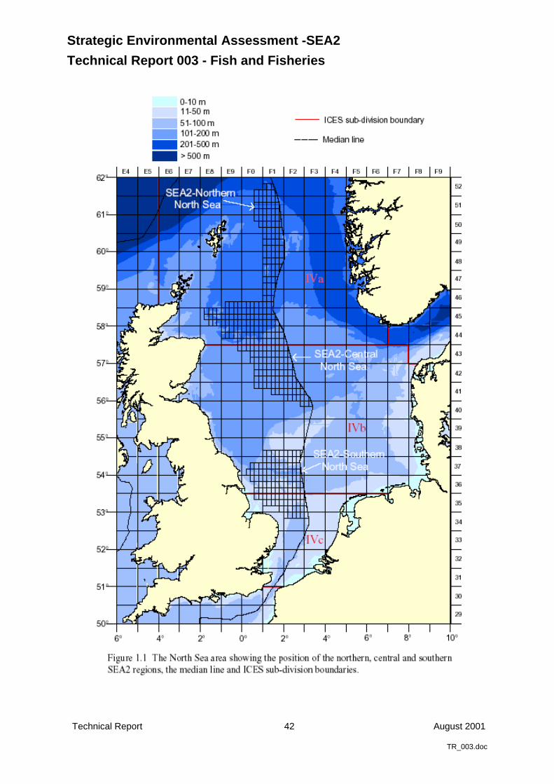
Strategic Environmental Assessment -SEA2
Technical Report 003 - Fish and Fisheries
Technical Report 42 August 2001
TR_003.doc
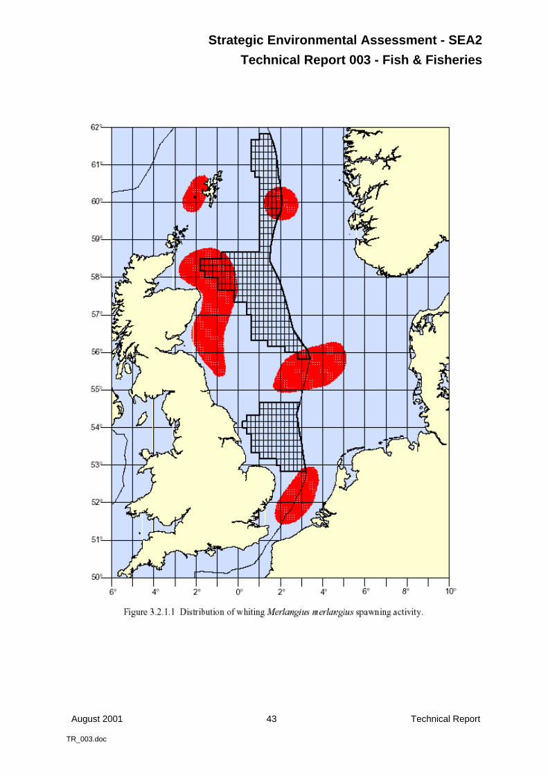
Strategic Environmental Assessment - SEA2
Technical Report 003 - Fish & Fisheries
August 2001 43 Technical Report
TR_003.doc
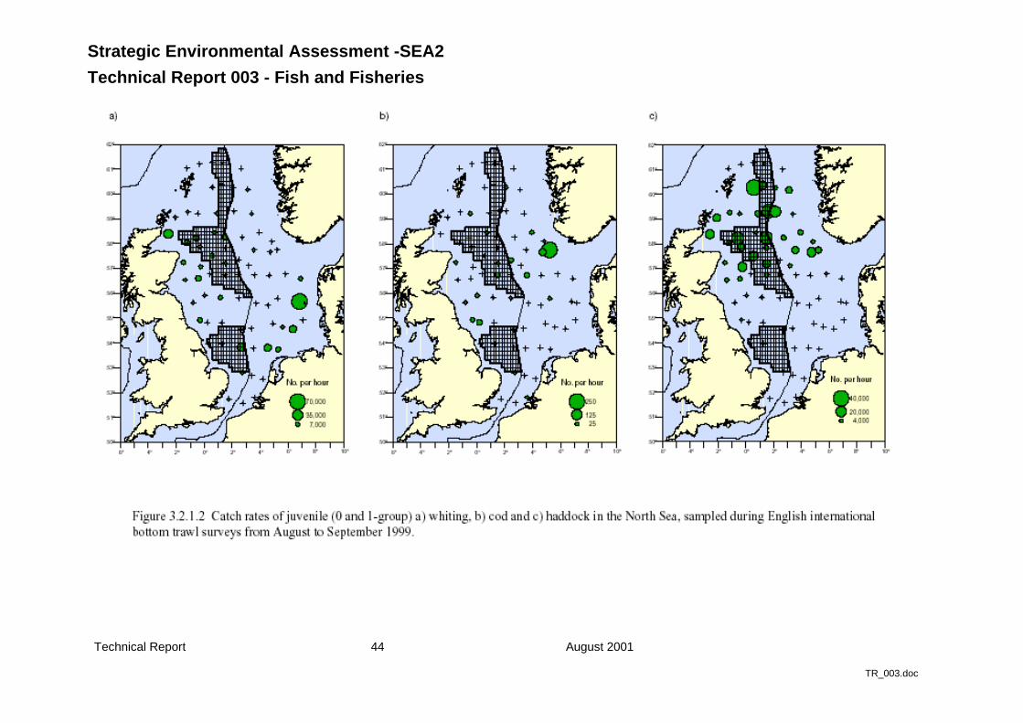
Strategic Environmental Assessment -SEA2
Technical Report 003 - Fish and Fisheries
Technical Report 44 August 2001
TR_003.doc
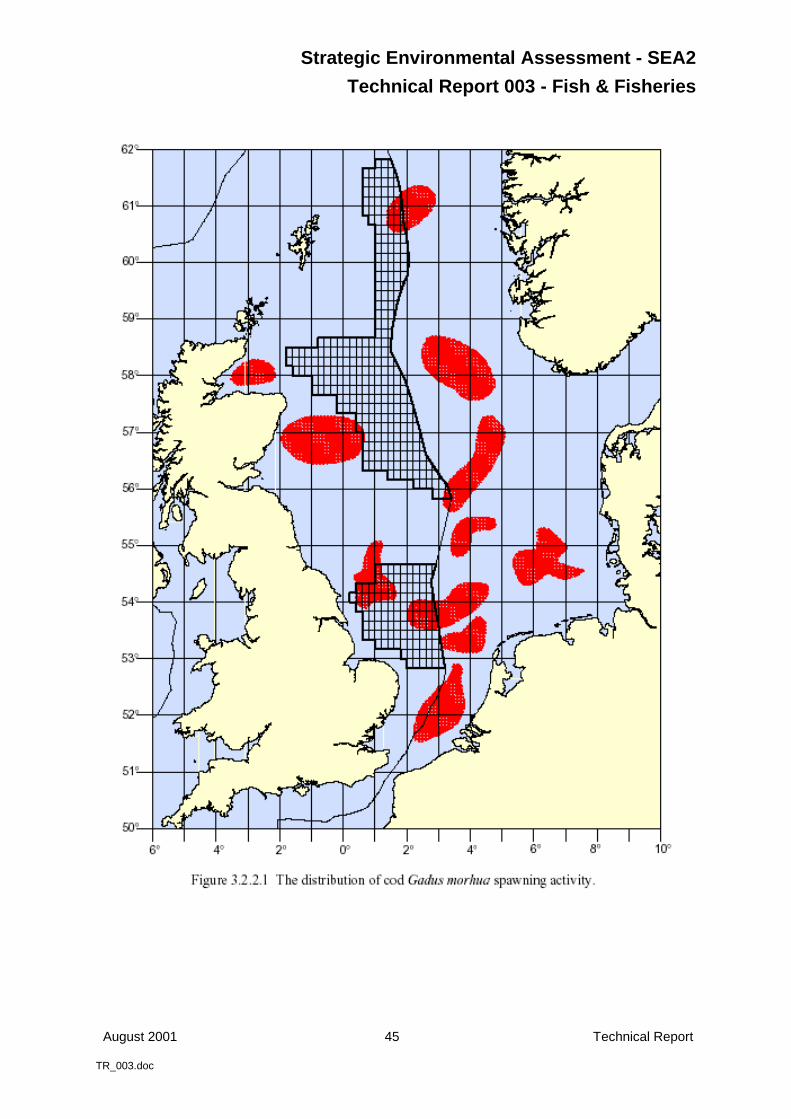
Strategic Environmental Assessment - SEA2
Technical Report 003 - Fish & Fisheries
August 2001 45 Technical Report
TR_003.doc
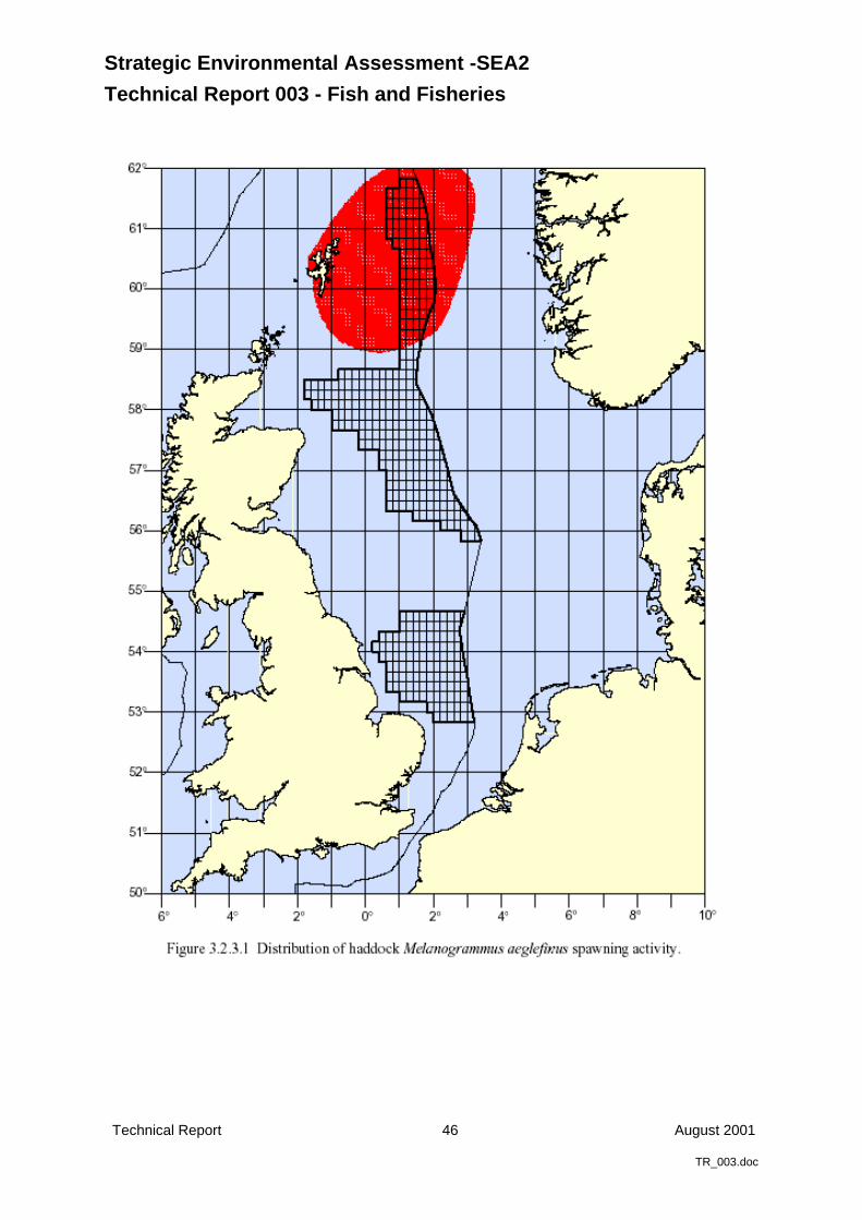
Strategic Environmental Assessment -SEA2
Technical Report 003 - Fish and Fisheries
Technical Report 46 August 2001
TR_003.doc
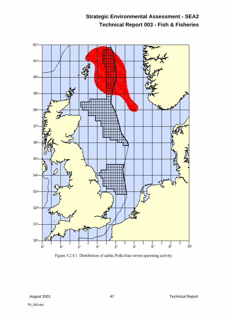
Strategic Environmental Assessment - SEA2
Technical Report 003 - Fish & Fisheries
August 2001 47 Technical Report
TR_003.doc
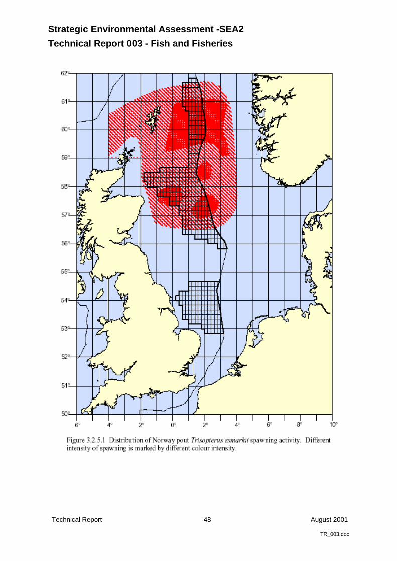
Strategic Environmental Assessment -SEA2
Technical Report 003 - Fish and Fisheries
Technical Report 48 August 2001
TR_003.doc
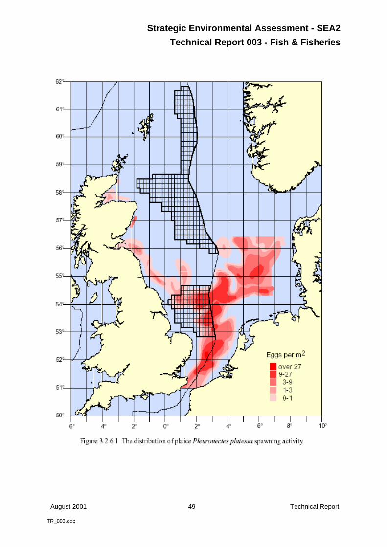
Strategic Environmental Assessment - SEA2
Technical Report 003 - Fish & Fisheries
August 2001 49 Technical Report
TR_003.doc
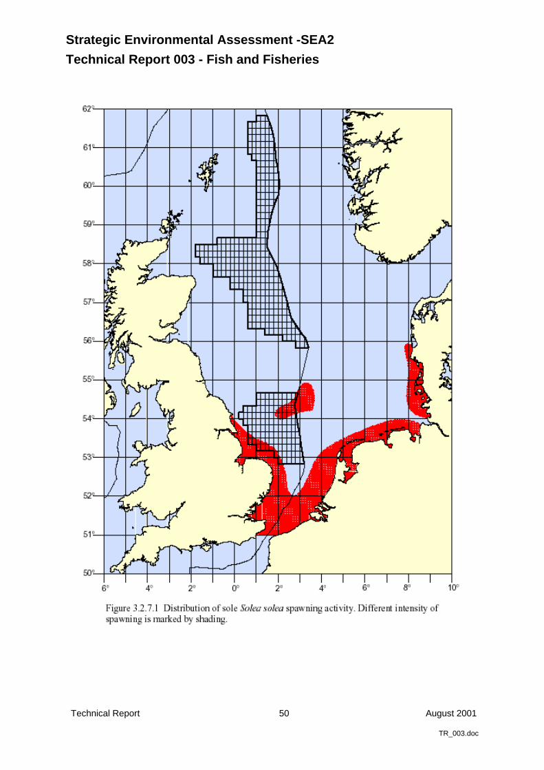
Strategic Environmental Assessment -SEA2
Technical Report 003 - Fish and Fisheries
Technical Report 50 August 2001
TR_003.doc
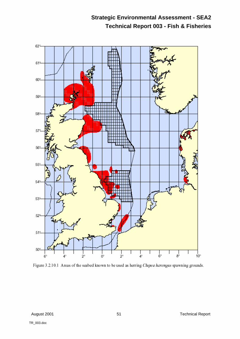
Strategic Environmental Assessment - SEA2
Technical Report 003 - Fish & Fisheries
August 2001 51 Technical Report
TR_003.doc
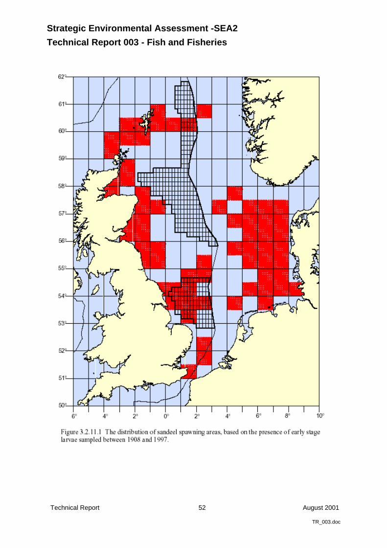
Strategic Environmental Assessment -SEA2
Technical Report 003 - Fish and Fisheries
Technical Report 52 August 2001
TR_003.doc
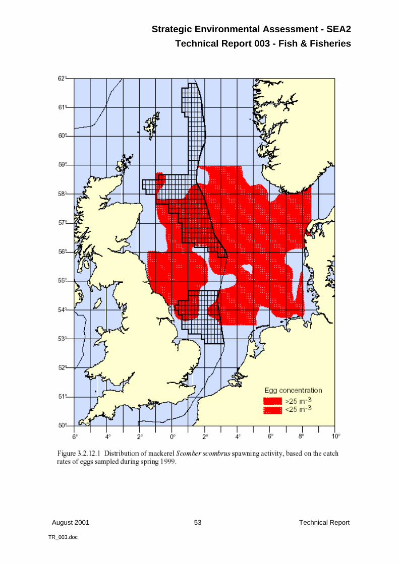
Strategic Environmental Assessment - SEA2
Technical Report 003 - Fish & Fisheries
August 2001 53 Technical Report
TR_003.doc
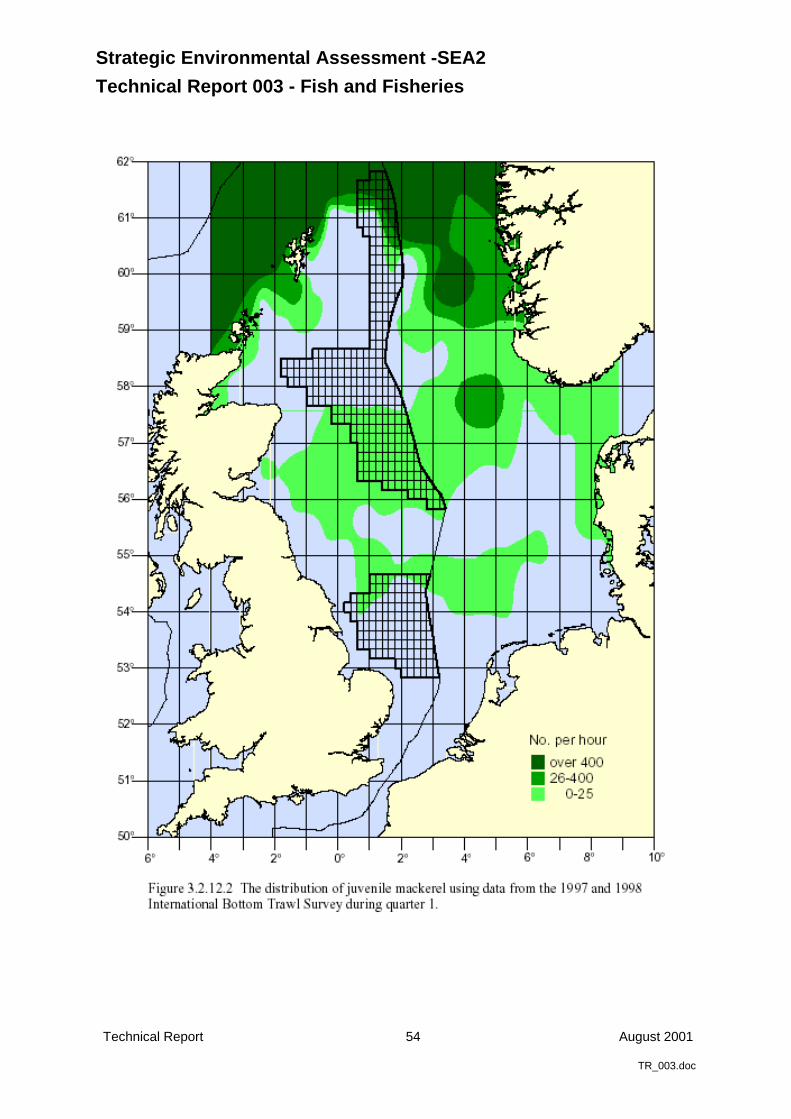
Strategic Environmental Assessment -SEA2
Technical Report 003 - Fish and Fisheries
Technical Report 54 August 2001
TR_003.doc
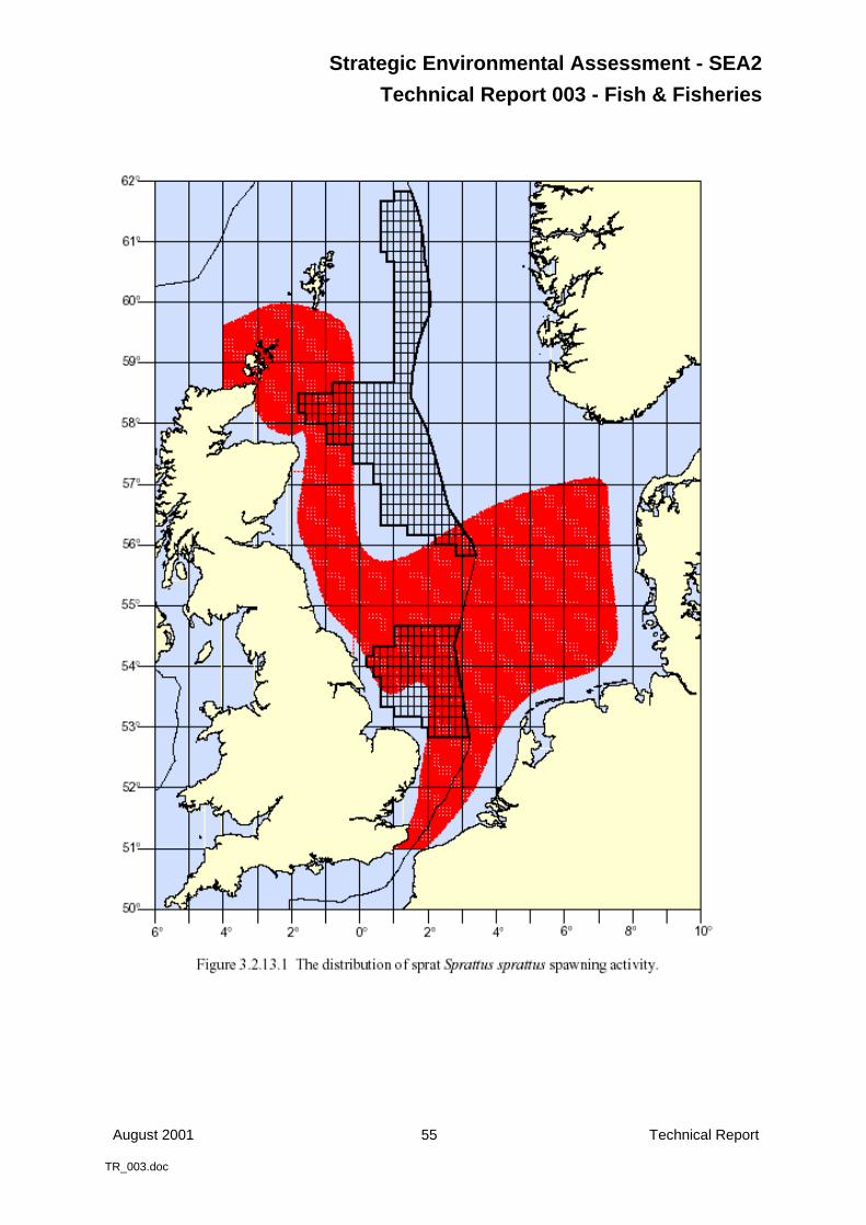
Strategic Environmental Assessment - SEA2
Technical Report 003 - Fish & Fisheries
August 2001 55 Technical Report
TR_003.doc

Strategic Environmental Assessment -SEA2
Technical Report 003 - Fish and Fisheries
Technical Report 56 August 2001
TR_003.doc
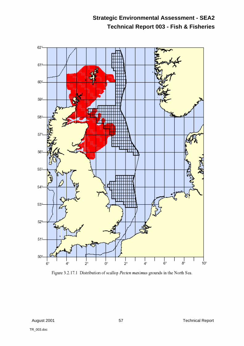
Strategic Environmental Assessment - SEA2
Technical Report 003 - Fish & Fisheries
August 2001 57 Technical Report
TR_003.doc
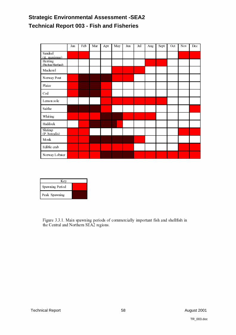
Strategic Environmental Assessment -SEA2
Technical Report 003 - Fish and Fisheries
Technical Report 58 August 2001
TR_003.doc
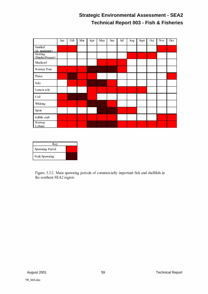
Strategic Environmental Assessment - SEA2
Technical Report 003 - Fish & Fisheries
August 2001 59 Technical Report
TR_003.doc
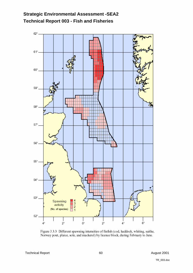
Strategic Environmental Assessment -SEA2
Technical Report 003 - Fish and Fisheries
Technical Report 60 August 2001
TR_003.doc
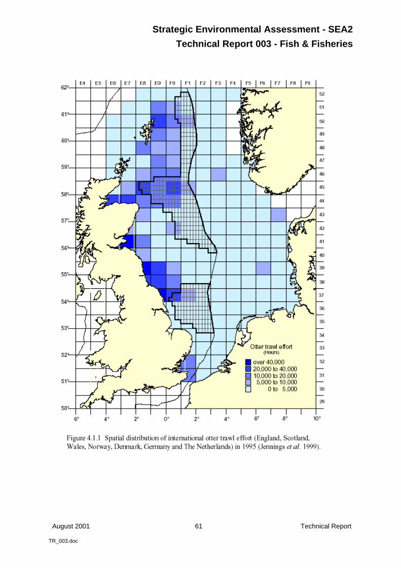
Strategic Environmental Assessment - SEA2
Technical Report 003 - Fish & Fisheries
August 2001 61 Technical Report
TR_003.doc
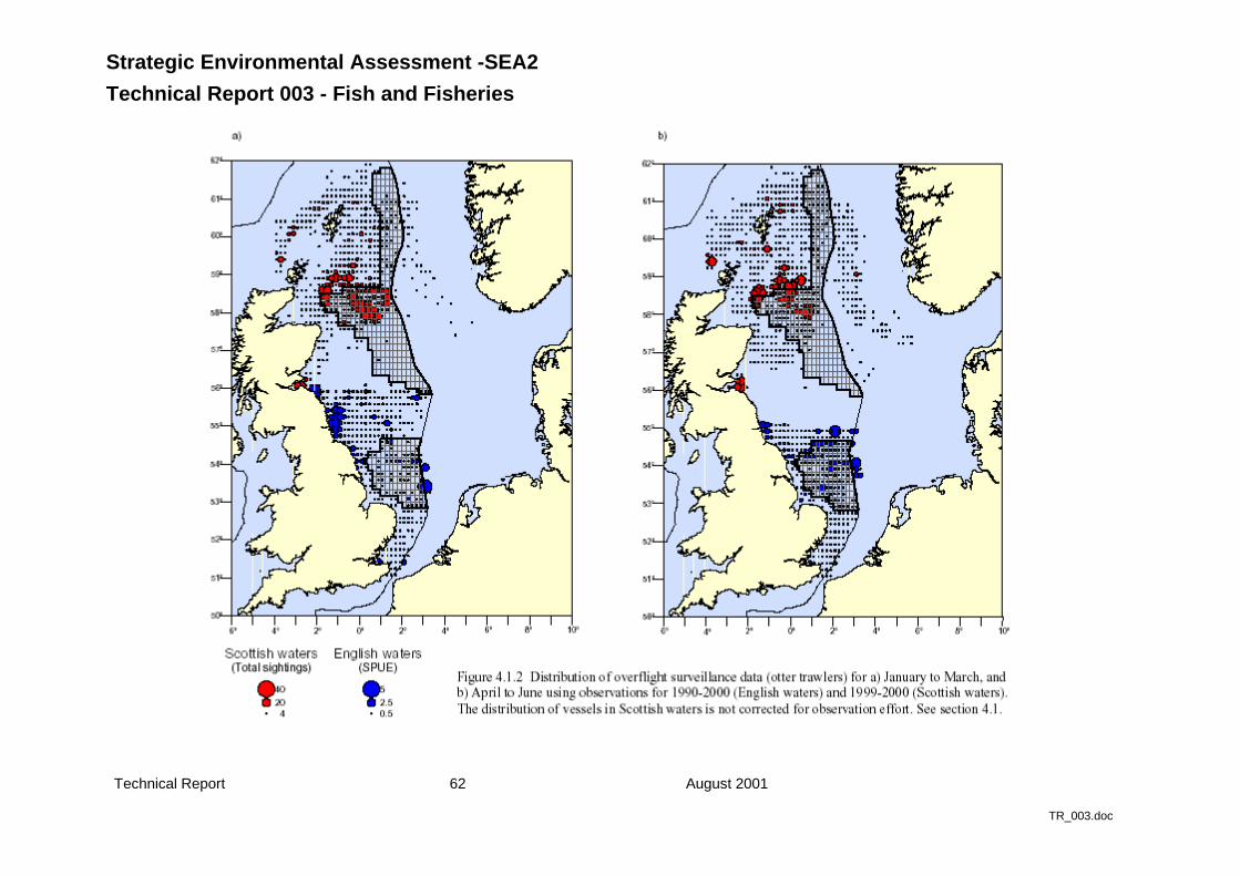
Strategic Environmental Assessment -SEA2
Technical Report 003 - Fish and Fisheries
Technical Report 62 August 2001
TR_003.doc

Strategic Environmental Assessment - SEA2
Technical Report 003 - Fish & Fisheries
August 2001 63 Technical Report
TR_003.doc
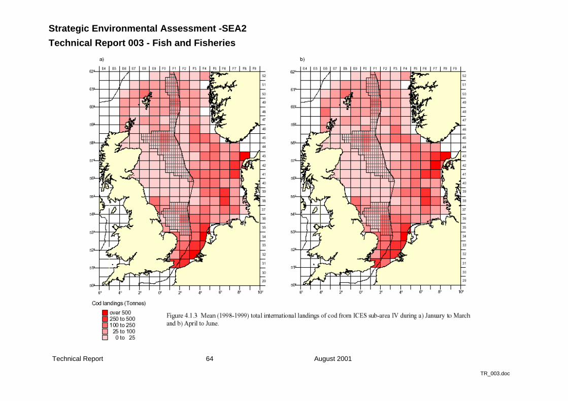
Strategic Environmental Assessment -SEA2
Technical Report 003 - Fish and Fisheries
Technical Report 64 August 2001
TR_003.doc
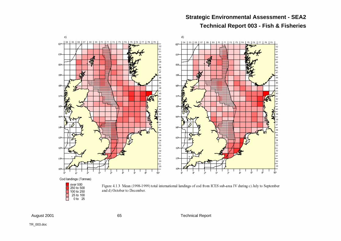
Strategic Environmental Assessment - SEA2
Technical Report 003 - Fish & Fisheries
August 2001 65 Technical Report
TR_003.doc
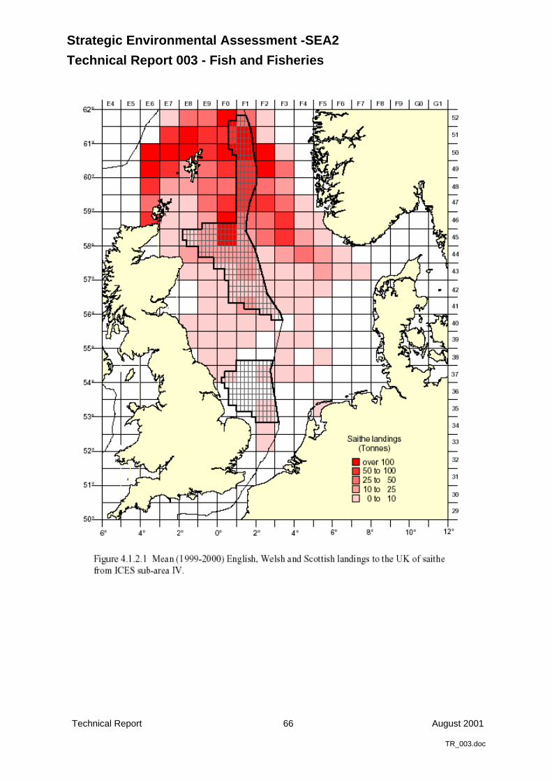
Strategic Environmental Assessment -SEA2
Technical Report 003 - Fish and Fisheries
Technical Report 66 August 2001
TR_003.doc
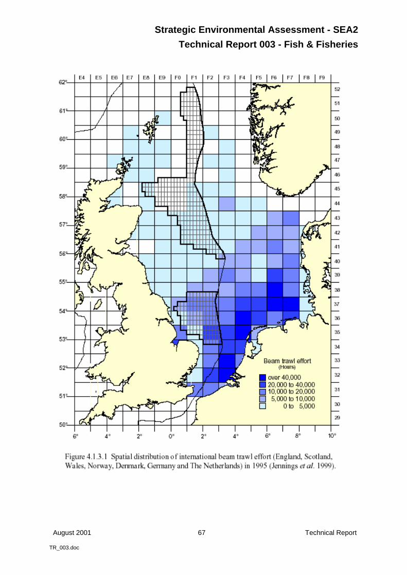
Strategic Environmental Assessment - SEA2
Technical Report 003 - Fish & Fisheries
August 2001 67 Technical Report
TR_003.doc

Strategic Environmental Assessment -SEA2
Technical Report 003 - Fish and Fisheries
Technical Report 68 August 2001
TR_003.doc
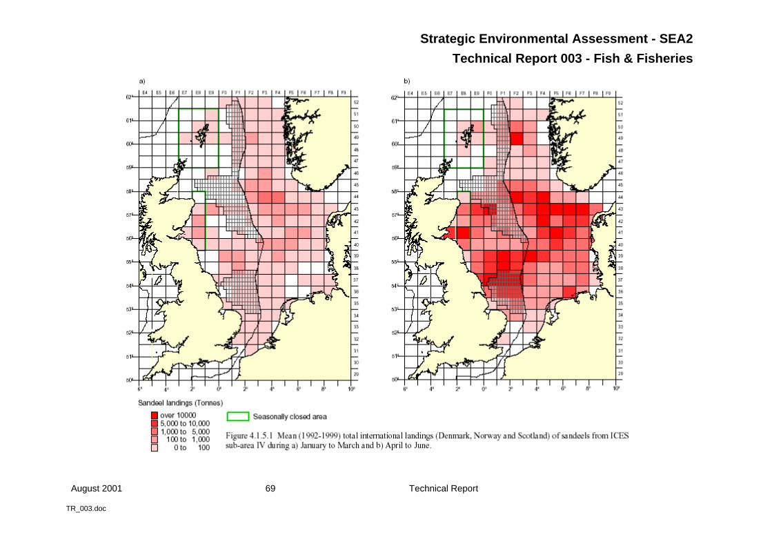
Strategic Environmental Assessment - SEA2
Technical Report 003 - Fish & Fisheries
August 2001 69 Technical Report
TR_003.doc
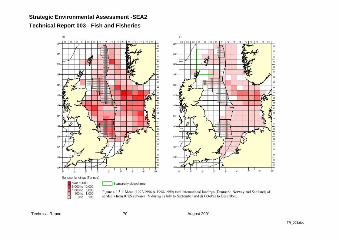
Strategic Environmental Assessment -SEA2
Technical Report 003 - Fish and Fisheries
Technical Report 70 August 2001
TR_003.doc
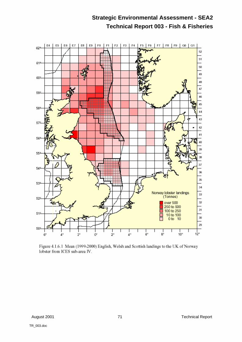
Strategic Environmental Assessment - SEA2
Technical Report 003 - Fish & Fisheries
August 2001 71 Technical Report
TR_003.doc
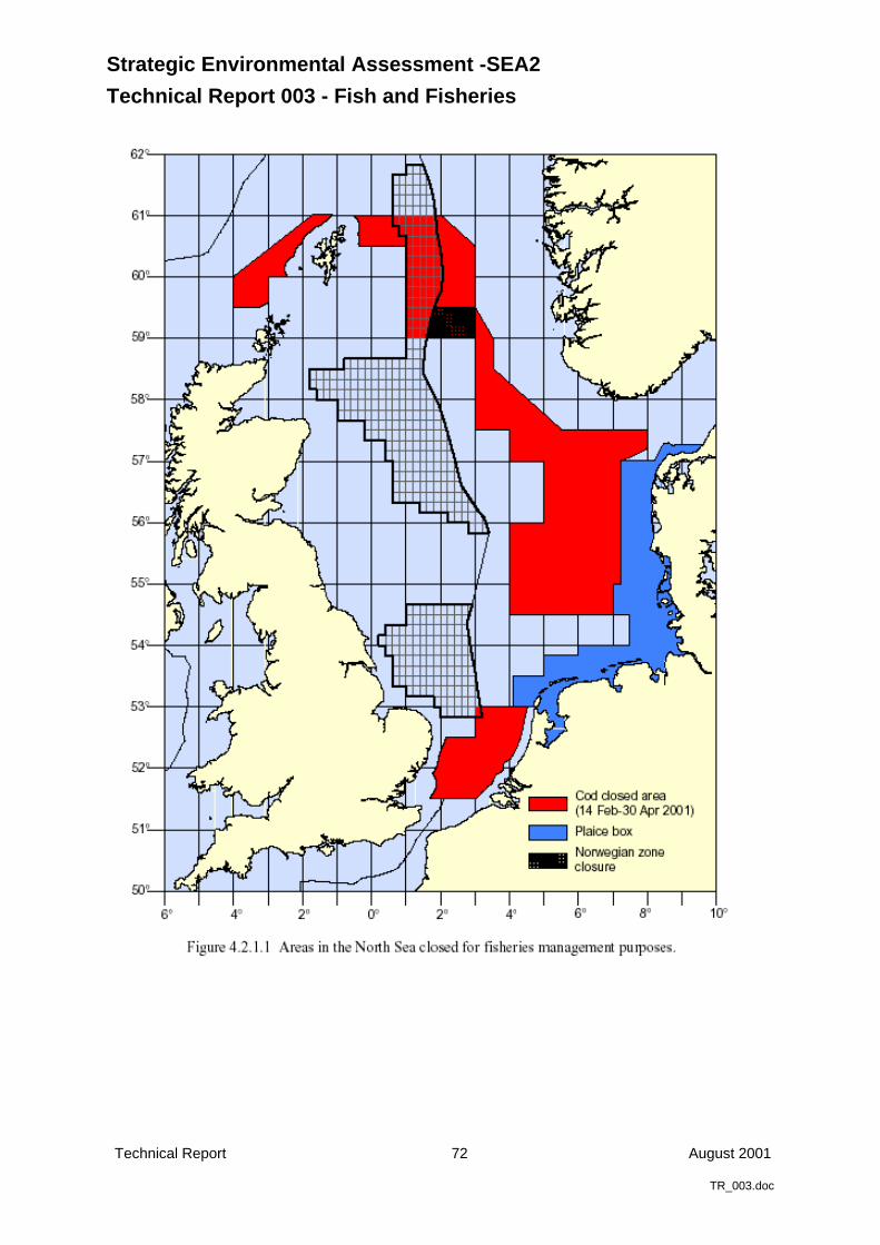
Strategic Environmental Assessment -SEA2
Technical Report 003 - Fish and Fisheries
Technical Report 72 August 2001
TR_003.doc