Embed Size (px)
Citation preview

Prepared for
Northampton
Level 2 Strategic Flood Risk Assessment
Living Document
February 2010
Northampton Strategic Flood Risk Assessment
Level 2
Scott Wilson Royal Court Basil Close Chesterfield Derbyshire S41 7SL Tel +44 (0)1246 209221 Fax +44 (0)1246 209229 www.scottwilson.com
This document has been prepared in accordance with the scope of Scott Wilson's appointment with its client and is subject to the terms of that appointment. It is addressed to and for the sole and confidential use and reliance of Scott Wilson's client. Scott Wilson accepts no liability for any use of this document other than by its client and only for the purposes for which it was prepared and provided. No person other than the client may copy (in whole or in part) use or rely on the contents of this document, without the prior written permission of the Company Secretary of Scott Wilson Ltd. Any advice, opinions, or recommendations within this document should be read and relied upon only in the context of the document as a whole. The contents of this document do not provide legal or tax advice or opinion. © Scott Wilson Ltd 2009
Revision Schedule Northampton Level 2 Strategic Flood Risk Assessment Final Report
REV DATE DETAILS PREPARED BY REVIEWED BY APPROVED BY
01 11/09/2009 Interim Draft Helen Judd Assistant Hydrologist
Michael Timmins Principal Consultant
Jon Robinson Associate Director
Fay Tivey Assistant Consultant
02 15/10/2009 Final Draft Fay Tivey Assistant Consultant
Michael Timmins Principal Consultant
Jon Robinson Associate Director
03 23/12/2009 Final 01 Fay Tivey Assistant Consultant
Michael Timmins Principal Consultant
Jon Robinson Associate Director
04 05/02/2010 Final 02 Fay Tivey Assistant Consultant
Michael Timmins Principal Consultant
Jon Robinson Associate Director

Northampton Strategic Flood Risk Assessment
Level 2
Final Level 2 SFRA Report D125262 February 2010
i
Table of Contents
Table of Contents........................................................................................ i
Abbreviations ............................................................................................ iii
Glossary .................................................................................................... iv
1 Introduction ..................................................................................... 1
1.1 Planning Context ............................................................................................................ 1
1.2 SFRA Overview .............................................................................................................. 1
1.3 Study Area...................................................................................................................... 2
1.4 Aims of the Level 2 SFRA............................................................................................... 3
1.5 Level 2 SFRA Objectives ................................................................................................ 4
2 Sequential Approach to Site Allocation......................................... 5
2.1 The Sequential Test........................................................................................................ 5
2.2 Development Vulnerability .............................................................................................. 6
2.3 Flood Zone Definition...................................................................................................... 7
2.4 The Exception Test......................................................................................................... 9
3 Methodology.................................................................................. 10
3.1 Background .................................................................................................................. 10
3.2 Level 2 SFRA Outputs .................................................................................................. 10
4 Screening of Development Areas ................................................ 12
4.1 Potential Development Areas ....................................................................................... 12
4.2 General Classification of Potential Development Areas ................................................ 13
5 Potential Development Areas with Defined Flood Risk.............. 14
5.1 Fluvial Defended Areas ................................................................................................ 14
5.2 Fluvial Undefended Areas............................................................................................. 20
5.3 Drainage Flooding ........................................................................................................ 25
6 Potential Development Areas with Undefined Flood Risk.......... 31
6.1 Fluvial Undefined Areas................................................................................................ 31
7 NLTGOS Areas .............................................................................. 36
7.1 Background .................................................................................................................. 36
7.2 Methodology ................................................................................................................. 36
7.3 Recommendations and Policies.................................................................................... 36
8 West Northamptonshire Emergent Joint Core Strategy............. 42

Northampton Strategic Flood Risk Assessment
Level 2
Final Level 2 SFRA Report D125262 February 2010
ii
9 Sustainable Drainage System Guidance ..................................... 48
9.1 Background .................................................................................................................. 48
9.2 Aim ............................................................................................................................... 48
9.3 Data, Methodology & Limitations .................................................................................. 49
10 Flood Risk Management ............................................................... 55
10.1 Flood Defences ............................................................................................................ 55
10.2 Flood Warning Areas .................................................................................................... 55
11 Policy and Practice ....................................................................... 57
11.1 SFRA Policies............................................................................................................... 57
11.2 Assessment of Impacts Upstream and Downstream..................................................... 58
11.3 Catchment Flood Management Plans........................................................................... 58
11.4 Surface Water Management Plan ................................................................................. 58
12 Site Specific Flood Risk Assessments ........................................ 59
12.1 Overview ...................................................................................................................... 59
12.2 Level 3 – Detailed / Site-Specific Flood Risk Assessment............................................. 59
12.3 Site Vulnerability and Site Layout ................................................................................. 59
12.4 Building Design............................................................................................................. 60
12.5 Storm Water Management............................................................................................ 61
12.6 Climate Change............................................................................................................ 64
13 Residual Risk Mitigation ............................................................... 65
13.2 Flood Resilience and Resistance Measures ................................................................. 65
13.3 Emergency Access and Egress .................................................................................... 66
13.4 Flood Warning and Evacuation Plans ........................................................................... 67
13.5 Sewer Flooding............................................................................................................. 68
14 Summary & Recommendations.................................................... 69
14.1 Summary ...................................................................................................................... 69
14.2 Recommendations........................................................................................................ 70
15 References..................................................................................... 72
Appendix A: Figures
Appendix B: NBC Review of Sites at Risk of Flooding
Appendix C: SUDS Map
Appendix D: Flood Hazard Maps for Defended Sites
Appendix E: Hazard Maps for Undefended Sites

Northampton Strategic Flood Risk Assessment
Level 2
Final Level 2 SFRA Report D125262 February 2010
iii
Abbreviations
ACRONYM DEFINITION
AEP Annual Exceedence Probability
AONB Area of Outstanding Natural Beauty
AWS Anglian Water
BW British Waterways
CFMP Catchment Flood Management Plan
DEM Digital Elevation Model
DPD Development Plan Documents
EA Environment Agency
EP English Partnerships
FRA Flood Risk Assessment
GIS Geographical Information Systems
GVW Groundwater Vulnerability
IDB Internal Drainage Board
LDDs Local Development Documents
LDF Local Development Framework
LDS Local Development Scheme
LiDAR Light Detection and Ranging
LPA Local Planning Authority
MKSMSRS Milton Keynes South Midlands Sub-Regional Strategy
NLTGOS Northampton Longer Term Growth Options Study
NBC Northampton Borough Council
ODPM Office of the Deputy Prime Minister
OPSI Office of Public Sector Information
PCPA Planning and Compulsory Purchase Act 2004
PPS25 Planning Policy Statement 25: Development and Flood Risk
RFRA Regional Flood Risk Assessment
RPG Regional Planning Guidance
RSS Regional Spatial Strategy
SW Scott Wilson
SAR Synthetic Aperture Radar
SA Sustainability Assessment
SFRA Strategic Flood Risk Assessment
SNC South Northamptonshire Council
SPG Supplementary Planning Guidance
SPZ Source Protection Zone
SSSI Site of Special Scientific Interest
SuDS Sustainable Drainage Systems

Northampton Strategic Flood Risk Assessment
Level 2
Final Level 2 SFRA Report D125262 February 2010
iv
Glossary
TERM DEFINITION
Aquifer A source of groundwater comprising water-bearing rock, sand or gravel capable of yielding significant quantities of water.
Catchment Flood Management Plan
A high-level planning strategy through which the Environment Agency works with their key decision makers within a river catchment to identify and agree policies to secure the long-term sustainable management of flood risk.
Climate Change Both natural and human actions causing long term variations in global temperature and weather patterns.
Culvert A channel or pipe that carries water below the level of the ground.
Flood Defence Infrastructure used to protect an area against floods as floodwalls and embankments; they are designed to a specific standard of protection (design standard).
Floodplain Area adjacent to river, coast or estuary that is naturally susceptible to flooding.
Flood Storage A temporary area that stores excess runoff or river flow often ponds or reservoirs.
Flood Zone 1 This zone comprises land assessed as having a less than 1 in 1000 annual probability of river or tidal flooding in any year (<0.1%).
Flood Zone 2 This zone comprises land assessed as having between a 1 in 100 and 1 in 1000 annual probability of river flooding (1% – 0.1%) or between a 1 in 200 and 1 in 1000 annual probability of tidal flooding (0.5% – 0.1%) in any year.
Flood Zone 3a This zone comprises land assessed as having a 1 in 100 or greater annual probability of river flooding (>1%) or a 1 in 200 or greater annual probability of flooding from the sea (>0.5%) in any year.
Flood Zone 3b
This zone comprises land where water has to flow or be stored in times of flood. SFRAs should identify this Flood Zone (land which would flood with an annual probability of 1 in 20 (5%) or greater in any year or is designed to flood in an extreme (0.1%) flood, or at another probability to be agreed between the LPA and the Environment Agency, including water conveyance routes).
Fluvial Flooding Flooding by a river or a watercourse.
Groundwater Water that is in the ground, this is usually referring to water in the saturated zone below the water table.
Internal Drainage Board
Independent bodies with responsibility of ordinary watercourses within a specified district.
Inundation Flooding

Northampton Strategic Flood Risk Assessment
Level 2
Final Level 2 SFRA Report D125262 February 2010
v
TERM DEFINITION
Local Development Framework
The core of the updated planning system (introduced by the Planning and Compulsory Purchase Act 2004). The LDF comprises the Local Development Documents, including the development plan documents that expand on policies and provide greater detail. The development plan includes a core strategy, site allocations and a proposals map.
Local Planning Authority
Body that is responsible for controlling planning and development through the planning system.
Main River
All watercourses shown as such on the statutory main river maps held by the Environment Agency and the Department of Environment, Food and Rural Affairs, and can include any structure or appliance for controlling or regulating flow of water into, in or out of the channel. The Environment Agency has permissive powers to carry out works of maintenance and improvement on these rivers.
Mitigation Measure An element of development design which may be used to manage flood risk or avoid an increase in flood risk elsewhere.
Pitt Review Sir Michael Pitt undertook an independent review of the Summer 2007 flood events. The full title of the document is ‘The Pitt Review: Lessons learned from the 2007 floods’
Risk The combination of probability and consequence of an event occurring.
Sequential Testing A risk based approach in to assessing flood risk, which gives priority in ascending order of flood risk, i.e. lowest risk first.
Sewer Flooding Flooding caused by a blockage or overflowing in a sewer or urban drainage system.
Stakeholder A person or organisation that has an interest in, or affected by the decisions made within a site.
Strata Layer of rock or soil with internally consistent characteristics that distinguishes it from contiguous layers. Each layer is generally one of a number of parallel layers that lie one upon another, laid down by natural forces.
Sustainability Appraisal
A process used to identify if policies, strategies or plans promote sustainable development and further used for improving policies. It is a requirement for Regional Spatial Strategies under the Planning and Compulsory Purchase Act 2004.
Sustainable Drainage System (SuDS)
Drainage methods designed to mimic the natural system. Where practicable should be used in preference to traditional piped drainage systems.
Sustainable Development
Development that meets the needs of the present without compromising the ability of future generations meeting their own needs.
X% Annual Exceedence Probability (AEP) event
Percentage annual exceedence probability (AEP) of occurrence in any one year. For example, a 1 in 200 annual probability event has a 0.5% AEP of occurring in any year.
X% AEP Design Standard
Flood defence that is designed for to protect against a X% AEP event. In events more severe than this the defence would be expected to fail or to allow flooding. For example, defences may be constructed to a standard of protection of 1% AEP.

Northampton Strategic Flood Risk Assessment
Level 2
Final Level 2 SFRA Report D125262 February 2010
1
1 Introduction
1.1 Planning Context
1.1.1 The Planning and Compulsory Purchase Act 2004 (PCPA)i requires Local Planning Authorities
(LPAs) to produce Local Development Frameworks (LDFs) to replace the system of Local,
Structure and Unitary Development Plans. LDFs are a portfolio of Local Development Documents
(LDDs) that collectively deliver the spatial planning strategy for the Local Authority area. The
PCPA requires LDDs to undergo a Sustainability Appraisal (SA), which assists Local Planning
Authorities (LPAs) in ensuring their policies fulfil the principles of sustainability.
1.1.2 Planning Policy Statement 25: Development and Flood Risk (PPS25, 2006)ii emphasises the
active role that LPAs should have in ensuring that flood risk is considered in strategic land use
planning. PPS25ii encourages LPAs to undertake a Strategic Flood Risk Assessment (SFRA).
SFRAs are one of the documents to be used as the evidence base for strategic land use
planning decisions as part of the LDF. They are also a component of the SA process and should
be used in the review of LDDs or in their production.
1.2 SFRA Overview
1.2.1 The PPS25ii Practice Guide
iii recommends that SFRAs are completed in two consecutive
stages:
• Level 1 SFRA,
• Level 2 SFRA.
1.2.2 Scott Wilson were commissioned by Daventry District Council (DDC), South Northamptonshire
Council (SNC) and Northampton Borough Council (NBC) to undertake a Strategic Flood Risk
Assessment (SFRA) for the sub-region of West Northamptonshire in December 2006. As part of
the commission, Scott Wilson were required to undertake a Level 1 and Level 2 SFRA for DDC
and SNC and review the existing Level 1 SFRA for NBC (undertaken by Bullen’s in 2002).
1.2.3 In August 2007, Scott Wilson issued a Final Level 1 SFRA to the commissioning authorities,
allowing Sequential Testing to be undertaken. Following the Councils completion of their
Sequential Tests, Scott Wilson then continued with the original commission and undertook a
Level 2 SFRA for SNC and DDC. Separate to this work, Scott Wilson undertook the Northampton
Level 2 Scoping Study, to determine the requirements for a Level 2 SFRA for Northampton.
1.2.4 Following the submission of the Final Level 1 SFRA the West Northamptonshire Joint Planning
Unit (WN JPU) undertook Sequential Testing. Spreadsheets containing the outputs from the
WN JPU Sequential Testing were supplied to Scott Wilson detailing the potential development
areas. The spreadsheets classified areas in accordance to their (PPS25) vulnerability
classification and whether or not they potentially require further assessment. Following this
process, thirty two (32) potential development areas were identified, which did not pass the
Sequential Test and therefore required further analysis.
1.2.5 In addition to the above areas, the WN JPU have also supplied a further forty two (42)
potential broad development areas as identified in the Northampton Longer Term Growth Options
Study (NLTGOS)iv.

Northampton Strategic Flood Risk Assessment
Level 2
Final Level 2 SFRA Report D125262 February 2010
2
1.2.6 There are a number of ongoing and imminent projects within the Level 2 SFRA study area
including:
• Environment Agency Breach Analysis for Central Northampton,
• Environment Agency Flood Defence Standard of Protection Review for Central
Northampton,
• Environment Agency Aquifer Designation Maps,
• Environment Agency Catchment Flood Management Plans (final versions),
• Northampton Surface Water Management Plan,
• Communities and Local Government updated PPS25 and PPS25 Practice Guide,
• Ofwat Determination.
Once complete, the above studies may be of significance to the Level 2 SFRA. As such, the
Level 2 SFRA is a ‘Living Document’ that should be updated and informed by emerging studies
that have a material effect on the SFRA.
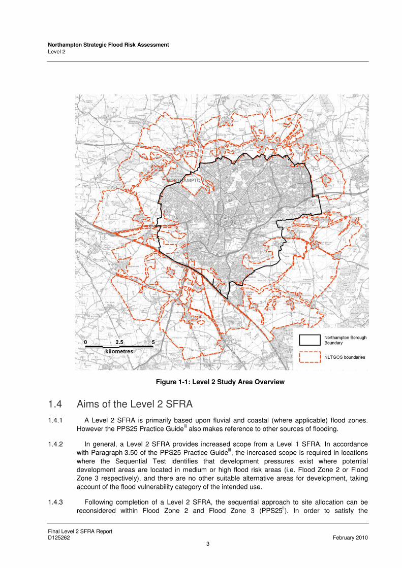
1.3 Study Area
1.3.1 The Level 2 SFRA study area consists of Northampton Borough Council administrative area
and the Northampton Longer Term Growth Options Study (NLTGOS) areas (Section 4). The
study area is presented in Figure 1-1 and Figure A-1 (Appendix A).
1.3.2 Northampton falls within the area covered by the Milton Keynes South Midlands Sub-Regional
Strategy (MKSM SRS)v. The MKSM SRS
v notes that the general area of Milton Keynes and the
South Midlands are identified as one of four potential major growth areas in the wider South East
Region of England. It is also highlighted that Northampton, defined as a Principal Urban Area
(PUA), will continue to grow in stature as an important regional centre and major areas of new
development will be concentrated here.
1.3.3 Daventry District Council (DDC), South Northamptonshire Council (SNC) and Northampton
Borough Council (NBC) are currently working together as the West Northamptonshire Joint
Planning Unit (WNJPU) to produce a ‘Joint Core Strategy’. The WNJPU published the West
Northamptonshire Emergent Joint Core Strategyvi for consultation in June 2009. Responses to
the Emergent Joint Core Strategy will influence the ‘pre-submission’ document, before being
submitted to government for examination.
1.3.4 This Level 2 SFRA covers the administrative area of NBC, including the rural hinterland and
the NLTGOS areas. A Level 2 SFRA for Daventry and South Northamptonshire has been
published separately as an Interim Report until this report is completed.
Northampton Strategic Flood Risk Assessment
Level 2
Final Level 2 SFRA Report D125262 February 2010
3
Figure 1-1: Level 2 Study Area Overview
1.4 Aims of the Level 2 SFRA
1.4.1 A Level 2 SFRA is primarily based upon fluvial and coastal (where applicable) flood zones.
However the PPS25 Practice Guideiii also makes reference to other sources of flooding.
1.4.2 In general, a Level 2 SFRA provides increased scope from a Level 1 SFRA. In accordance
with Paragraph 3.50 of the PPS25 Practice Guideiii, the increased scope is required in locations
where the Sequential Test identifies that development pressures exist where potential
development areas are located in medium or high flood risk areas (i.e. Flood Zone 2 or Flood
Zone 3 respectively), and there are no other suitable alternative areas for development, taking
account of the flood vulnerability category of the intended use.
1.4.3 Following completion of a Level 2 SFRA, the sequential approach to site allocation can be
reconsidered within Flood Zone 2 and Flood Zone 3 (PPS25ii). In order to satisfy the

Northampton Strategic Flood Risk Assessment
Level 2
Final Level 2 SFRA Report D125262 February 2010
4
requirements of the Exception Test to be incorporated into the LDDs, the Level 2 SFRA will
ensure that policies and practices are considered for development areas located in areas of flood
risk.
1.5 Level 2 SFRA Objectives
1.5.1 As identified by the Northampton Level 2 SFRA Scoping Studyvii
, the main objectives of this
Level 2 SFRA are:
• An appraisal of the current location, condition, operating standard and level of protection
offered by flood defence infrastructure and of the likely future flood management policy with
regards to its maintenance and upgrade;
• An appraisal of the probability and consequences of overtopping or failure of flood risk
management infrastructure, including estimating the rate and onset of flooding and the
velocity and depth of flooding with allowance for climate change;
• Definition and mapping of the functional floodplain in locations where this is required,
including undefended watercourses;
• Maps showing the distribution of flood risk across all flood zones from all sources of flooding
with allowance for climate change;
• Guidance on appropriate policies for areas which satisfy parts a) and b) of the Exception
Test, and requirements to consider at the planning application stage to pass part c) of the
Exception Test;
• Guidance on the preparation of Flood Risk Assessments (FRAs) for areas of varying risk
across the flood zones should be provided to enable developers to adhere to flood risk
policies. This guidance should include information about the use of Sustainable Drainage
Systems (SuDS) techniques including the administrative area of NBC and its hinterland;
• Identification of the location of Critical Drainage Areas (CDAs) and identification of the need
for a Surface Water Management Plan (SWMP) or a series of area specific SWMPs;
• Meaningful recommendations to inform policy, development control and technical issues;
• Assessment of other residual risks in line with Chapter 7 of PPS25;
• Assessment of risks to other areas upstream and downstream of the areas of interest as a
result of development;
• Identifications of strategic flood alleviation measures for reducing flood risk.

Northampton Strategic Flood Risk Assessment
Level 2
Final Level 2 SFRA Report D125262 February 2010
5
2 Sequential Approach to Site Allocation
2.1 The Sequential Test
2.1.1 The Sequential Test is a simple decision making tool designed to ensure that sites at little or
no risk of flooding are developed in preference to areas at higher risk. Where new development is
necessary in high flood risk areas, it should be directed to sites with the lowest probability of
flooding and the flood vulnerability of the intended use should be matched to the flood risk of the
site, e.g. higher vulnerability uses located on parts of the site at lowest probability of flooding. The
Sequential Test should be applied before moving onto the Exception Test.
2.1.2 Sequential Testing has been undertaken by the West Northamptonshire LPAs in accordance
with the following guidance (see Appendix B). This Sequential Testing will be updated throughout
the course of the LDF.
2.1.3 In order to determine the suitability of land for development in flood risk areas, the
development vulnerability must first be established. Table 2-1 replicates Table D.3 from Annex D
of PPS25, and illustrates a matrix of ‘Flood Risk Vulnerability’ of a proposed development against
‘Flood Zone Compatibility’. It is important to note that if development is considered compatible
with regard to vulnerability and flood risk, it is subject to passing the Sequential Test.
Table 2-1: Flood Risk Vulnerability and Flood Zone ‘Compatibility’ (extracted from PPS25)
FLOOD RISK
VULNERABILITY
CLASSIFICATION
ESSENTIAL
INFRASTRUCTURE
WATER
COMPATIBLE
HIGHLY
VULNERABLE
MORE
VULNERABLE
LESS
VULNERABLE
1 � � � � �
2 � � Exception Test
required � �
3A Exception Test required
� � Exception Test
required �
FLOOD
ZONE
3B Exception Test required
� � � �
� Development is appropriate � Development should not be permitted
Northampton Strategic Flood Risk Assessment
Level 2
Final Level 2 SFRA Report D125262 February 2010
6
2.2 Development Vulnerability
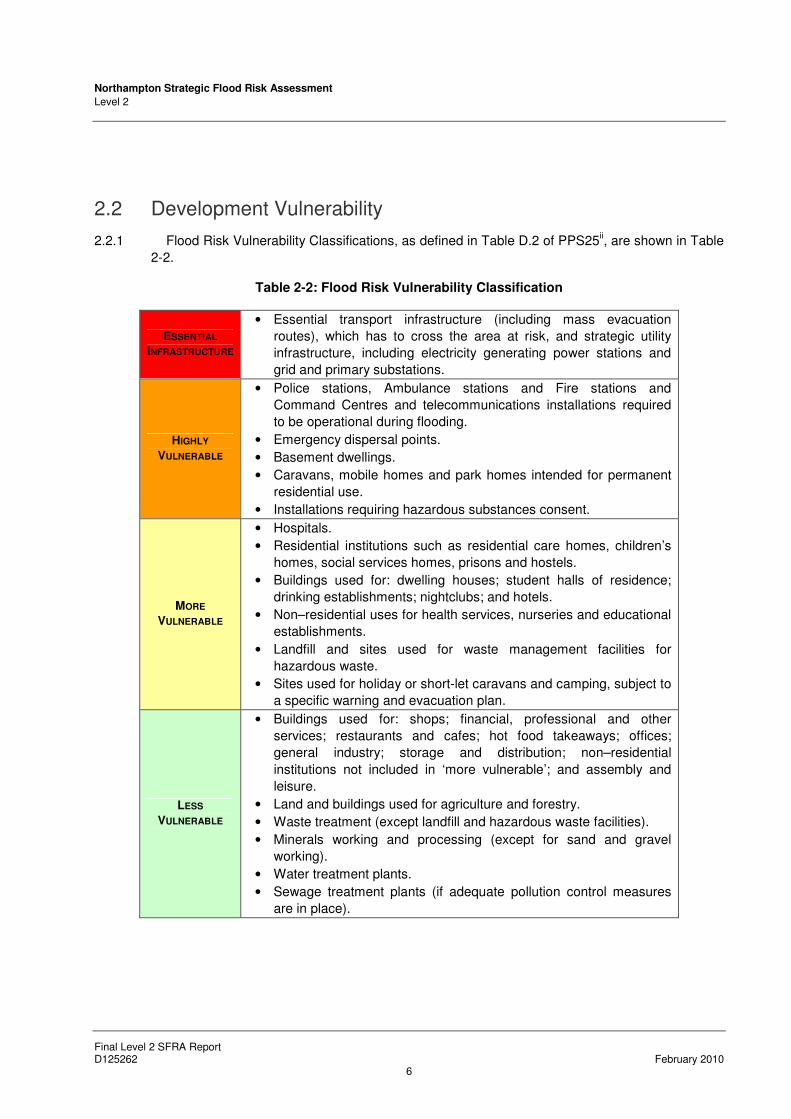
2.2.1 Flood Risk Vulnerability Classifications, as defined in Table D.2 of PPS25ii, are shown in Table
2-2.
Table 2-2: Flood Risk Vulnerability Classification
ESSENTIAL
INFRASTRUCTURE
• Essential transport infrastructure (including mass evacuation
routes), which has to cross the area at risk, and strategic utility
infrastructure, including electricity generating power stations and
grid and primary substations.
HIGHLY
VULNERABLE
• Police stations, Ambulance stations and Fire stations and
Command Centres and telecommunications installations required
to be operational during flooding.
• Emergency dispersal points.
• Basement dwellings.
• Caravans, mobile homes and park homes intended for permanent
residential use.
• Installations requiring hazardous substances consent.
MORE
VULNERABLE
• Hospitals.
• Residential institutions such as residential care homes, children’s
homes, social services homes, prisons and hostels.
• Buildings used for: dwelling houses; student halls of residence;
drinking establishments; nightclubs; and hotels.
• Non–residential uses for health services, nurseries and educational
establishments.
• Landfill and sites used for waste management facilities for
hazardous waste.
• Sites used for holiday or short-let caravans and camping, subject to
a specific warning and evacuation plan.
LESS
VULNERABLE
• Buildings used for: shops; financial, professional and other
services; restaurants and cafes; hot food takeaways; offices;
general industry; storage and distribution; non–residential
institutions not included in ‘more vulnerable’; and assembly and
leisure.
• Land and buildings used for agriculture and forestry.
• Waste treatment (except landfill and hazardous waste facilities).
• Minerals working and processing (except for sand and gravel
working).
• Water treatment plants.
• Sewage treatment plants (if adequate pollution control measures
are in place).
Northampton Strategic Flood Risk Assessment
Level 2
Final Level 2 SFRA Report D125262 February 2010
7
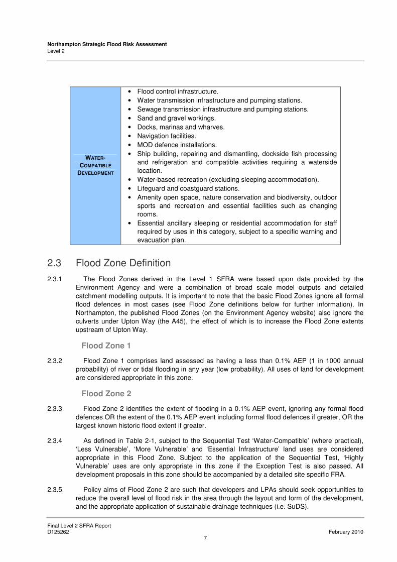
WATER-
COMPATIBLE
DEVELOPMENT
• Flood control infrastructure.
• Water transmission infrastructure and pumping stations.
• Sewage transmission infrastructure and pumping stations.
• Sand and gravel workings.
• Docks, marinas and wharves.
• Navigation facilities.
• MOD defence installations.
• Ship building, repairing and dismantling, dockside fish processing
and refrigeration and compatible activities requiring a waterside
location.
• Water-based recreation (excluding sleeping accommodation).
• Lifeguard and coastguard stations.
• Amenity open space, nature conservation and biodiversity, outdoor
sports and recreation and essential facilities such as changing
rooms.
• Essential ancillary sleeping or residential accommodation for staff
required by uses in this category, subject to a specific warning and
evacuation plan.
2.3 Flood Zone Definition
2.3.1 The Flood Zones derived in the Level 1 SFRA were based upon data provided by the
Environment Agency and were a combination of broad scale model outputs and detailed
catchment modelling outputs. It is important to note that the basic Flood Zones ignore all formal
flood defences in most cases (see Flood Zone definitions below for further information). In
Northampton, the published Flood Zones (on the Environment Agency website) also ignore the
culverts under Upton Way (the A45), the effect of which is to increase the Flood Zone extents
upstream of Upton Way.
Flood Zone 1
2.3.2 Flood Zone 1 comprises land assessed as having a less than 0.1% AEP (1 in 1000 annual
probability) of river or tidal flooding in any year (low probability). All uses of land for development
are considered appropriate in this zone.
Flood Zone 2
2.3.3 Flood Zone 2 identifies the extent of flooding in a 0.1% AEP event, ignoring any formal flood
defences OR the extent of the 0.1% AEP event including formal flood defences if greater, OR the
largest known historic flood extent if greater.
2.3.4 As defined in Table 2-1, subject to the Sequential Test ‘Water-Compatible’ (where practical),
‘Less Vulnerable’, ‘More Vulnerable’ and ‘Essential Infrastructure’ land uses are considered
appropriate in this Flood Zone. Subject to the application of the Sequential Test, ‘Highly
Vulnerable’ uses are only appropriate in this zone if the Exception Test is also passed. All
development proposals in this zone should be accompanied by a detailed site specific FRA.
2.3.5 Policy aims of Flood Zone 2 are such that developers and LPAs should seek opportunities to
reduce the overall level of flood risk in the area through the layout and form of the development,
and the appropriate application of sustainable drainage techniques (i.e. SuDS).

Northampton Strategic Flood Risk Assessment
Level 2
Final Level 2 SFRA Report D125262 February 2010
8
Flood Zone 3a
2.3.6 Flood Zone 3a identifies the extent of flooding in a 1% AEP (100 year) event, ignoring any
formal flood defences, OR the extent of the 1% AEP event including formal flood defences if
greater. This Flood Zone also includes the extent of any formal flood storage areas.
2.3.7 As defined in Table 2-1, subject to the Sequential Test ‘Water-Compatible’ (where practical)
and ‘Less Vulnerable’ land uses are appropriate in this zone. ‘Highly Vulnerable’ land uses
should not be permitted in this zone. ‘More Vulnerable’ and ‘Essential Infrastructure’ uses should
only be permitted in this zone if the Exception Test is passed. ‘Essential Infrastructure’ permitted
in this zone should be designed and constructed to remain operational and safe for users in
times of flood. All development proposals in this zone should be accompanied by a detailed site
specific FRA.
2.3.8 Policy aims of Flood Zone 3a are such that developers and LPAs should seek opportunities to:
• Relocate existing development to land in zones with a lower probability of flooding,
• Reduce the overall level of flood risk in the area through the layout and form of the
development, and the appropriate application of sustainable drainage techniques,
• Create space for flooding to occur by restoring functional floodplain and flood flow paths and
by identifying, allocating and safeguarding open space for flood storage.
Flood Zone 3b – Functional Floodplain
2.3.9 Flood Zone 3b comprises land where water has to flow or be stored in times of flood with 5%
AEP (1 in 20 annual probability) or greater of river flooding in any year or is designed to flood in
an extreme flood (0.1% AEP), or at another probability to be agreed between the LPA and the
Environment Agency (EA).
2.3.10 As defined in Table 2-1, subject to the Sequential Test only the ‘Water-Compatible’ (where
practical) and ‘Essential Infrastructure’ land uses should be permitted in this zone. Any permitted
development within Flood Zone 3b should be designed and constructed to:
• Remain operational and safe for users in times of flood,
• Result in no net loss of floodplain storage,
• Not impede water flows,
• Not increase flood risk elsewhere.
2.3.11 ‘Essential Infrastructure’ in this zone should also pass the Exception Test. All development
proposals in this zone should be accompanied by a detailed site specific FRA.
2.3.12 Policy aims in Flood Zone 3b are such that developers and LPAs should seek opportunities to:
• Reduce the overall level of flood risk in the area through the layout and form of the
development and the appropriate application of sustainable drainage techniques (i.e.
SuDS),
• Relocate existing development to land with a lower probability of flooding.

Northampton Strategic Flood Risk Assessment
Level 2
Final Level 2 SFRA Report D125262 February 2010
9
2.4 The Exception Test
2.4.1 Development is only permissible in areas at risk of flooding where it can be demonstrated that
there are no reasonably available sites in areas of lower risk and that the benefits outweigh the
risks from flooding. As such, the development must pass the Exception Test (applied by the LPA
using evidence supplied by either the Level 2 SFRA or a site specific FRA), which is a method of
managing flood risk while still allowing necessary development to occur.
2.4.2 Where there are no reasonably available sites in Flood Zone 1, decision makers should
consider reasonably available sites in Flood Zone 2 taking into account the flood risk vulnerability
of land uses and applying the Exception Test if required. Only where there are no reasonably
available sites in Flood Zone 1 or Flood Zone 2 should decision makers consider sites in Flood
Zone 3, taking into account flood risk vulnerability and applying the Exception Test if required.
2.4.3 Following the Sequential Test ‘More Vulnerable’ land uses within Flood Zone 3a and ‘highly
vulnerable’ land uses within Flood Zone 2 should only be permitted if an Exception Test has been
passed.
2.4.4 Therefore the undertaking of the Exception Test will be required for any proposed residential
development within Flood Zone 3a as shown in Table 2-1 and Table 2-2.
2.4.5 PPS25 states that for the Exception Test to be passed, three main criteria must be satisfied in
order for the development to be considered acceptable:
Part A - “It must be demonstrated that the development provides wider sustainability
benefits to the community that outweigh flood risk, informed by an SFRA where one has
been prepared. If the DPD has reached the ‘submission’ stage – the benefits of the
development should contribute to the Core Strategy’s Sustainability Appraisal”,
Part B – “The development should be on developable previously-developed land or, if it
is not on previously developed land, that there are no reasonable alternative sites on
developable previously-developed land”,
Part C - A FRA must demonstrate that the development will be safe, without increasing
flood risk elsewhere, and, where possible will reduce the flood risk overall”.
2.4.6 For successful application it is important that the arguments presented for justification through
the Exception Test are in line with policies set out in Local Plans and the LDF, supported by
reference to other national planning and sustainability policies, such as development of
greenfield sites.
2.4.7 This Level 2 SFRA aims to provide information relating to Part C of the Exception Test.
However, NBC / WN JPU will need to provide evidence that Part A and Part B of the Exception
Test can be satisfied, part of the evidence base for which should be informed by the Level 1
SFRA, LPA Sequential Testing and this Level 2 SFRA.

Northampton Strategic Flood Risk Assessment
Level 2
Final Level 2 SFRA Report D125262 February 2010
10
3 Methodology
3.1 Background
3.1.1 It is important to be clear that a Level 2 SFRA is not a replacement for site specific FRAs. Its
purpose is strategic in nature to inform planning and policy decisions to the area in question
within a district. There is no clear definition of the scale at which a Level 2 assessment should be
undertaken in PPS25ii or the accompanying Practice Guide
iii. However, in other SFRAs across
the country, a Level 2 SFRA has concentrated on individual towns and settlements or large
development or regeneration areas within a District.
3.1.2 A Level 2 SFRA uses information gathered during a Level 1 SFRA, and additional data where
necessary, and concentrates on potential development areas to determine detailed information
on the level of flood risk so that sufficient evidence can be provided for the Exception Test to be
applied.
3.1.3 This continues the hierarchical approach to flood risk defined in PPS25ii and provides Local
Planning Authorities (LPAs) with more information to ensure that development follows the
sequential approach and, if applicable, to apply the Exception Test and determine possible site
layouts and/or policies that ensure flood risk is minimised to new development.
3.1.4 A Level 2 SFRA may not be necessary for all LPAs as it may have been possible to allocate all
proposed development and infrastructure, in accordance with the Sequential Test, to areas of
lower flood risk. For other LPAs, there is a much higher probability that a Level 2 SFRA will be
required due to the extent of flood risk issues and the location and scale of proposed
development.
3.2 Level 2 SFRA Outputs
3.2.1 Following discussions with representatives from the Environment Agency, Northampton BC
and WNJPU, and in accordance with PPS25 and the Practice Guide, the following outputs will be
produced as part of this Level 2 SFRA:
• Location, condition, operating standard and level of protection offered by flood defences and
flood risk management structures;
• An appraisal of the probability and consequences of overtopping or breach of defences
including estimating the rate and onset of flooding and the velocity and depth flooding. This
facilitates the production of rapid inundation zones and flood hazard maps;
• Using the above information, the flood risk within and across flood zones at a site or in an
area can be determined. This allows policies and guidelines to be developed that place less
vulnerable development and water compatible land use (for example, playing fields) in areas
of higher risk, whilst development of higher vulnerability is placed in areas of lower flood
risk;
• Production of FRA guidelines for sites or areas to enable developers to adhere to flood risk
policies;
• Assessment of residual risks, including emergency response, access and egress; and,
Northampton Strategic Flood Risk Assessment
Level 2
Final Level 2 SFRA Report D125262 February 2010
11
• Assessment of risks to other areas upstream and downstream of the area of interest as a
result of development;
• Identification of potential areas where strategic flood risk management schemes may be
appropriate.

Northampton Strategic Flood Risk Assessment
Level 2
Final Level 2 SFRA Report D125262 February 2010
12
4 Screening of Development Areas
4.1 Potential Development Areas
4.1.1 Following the submission of the Level 1 SFRA, the WN JPU have undertaken Sequential
Testing. Spreadsheets containing the outputs from the WN JPU Sequential Testing were
supplied to Scott Wilson, detailing the potential development areas as part of the Level 2 SFRA
Scoping Study. The spreadsheets classified potential development areas in accordance to their
(PPS25) vulnerability classification and whether or not they potentially require further
assessment. Following this process, further information was required to assess the flood risk to
32 potential development areas in order to inform the Sequential and Exception Tests. The areas
are summarised in Appendix B and shown on Figure A-2 (Appendix A). The Sequential Testing
will be updated throughout the course as the LDF progresses.
4.1.2 The Northampton Longer Term Growth Options Study (NLTGOS) was completed by EDAW /
AECOM in March 2007 on behalf of the West Northamptonshire Local Authorities. One objective
of the NLTGOS was to evaluate the options for the most sustainable direction or directions of
longer-term growth in relation to the town of Northampton. The study identified 42 potential broad
development areas. Although the broad development areas have not been Sequentially Tested,
the areas will be considered as part of the Level 2 SFRA. If NLTGOS areas are considered for
allocation in the future, the Sequential and Exception Tests should be applied and further work
may be necessary. Figure A-3 (Appendix A) shows the distribution of the broad growth areas
from the NLTGOS.
Figure 4-1: NLTGOS areas overview

Northampton Strategic Flood Risk Assessment
Level 2
Final Level 2 SFRA Report D125262 February 2010
13
4.2 General Classification of Potential Development Areas
4.2.1 As part of the Scoping Study and using the data provided by the WN JPU (Sequential Testing
and NLTGOS areas), the areas have been split into three main classifications:
• Potential development areas with defined Flood Risk:
o Areas with a defended fluvial flood risk (Section 5.1);
o Areas with an undefended fluvial flood risk (Section 5.2)
o Areas affected by drainage flooding (Section 5.3).
• Potential development areas with undefined Flood Risk (Section 6.1);
• NLTGOS Areas (Section 7).
4.2.2 The methodology and approach to the Level 2 assessments for each category identified above
is relative to the flood risk issues in each category. This approach has been developed and
agreed in consultation with representatives from NBC, SNC, DDC, WNJPU and the Environment
Agency.

Northampton Strategic Flood Risk Assessment
Level 2
Final Level 2 SFRA Report D125262 February 2010
14
5 Potential Development Areas with Defined Flood Risk
5.1 Fluvial Defended Areas
Background
5.1.1 There are seven potential development areas that benefit from fluvial flood defences. These
areas are considered to have a residual risk of flooding associated with a breach of flood
defences. The areas are shown in Figure A-2 (i), Appendix A and listed in Table 5-1.
5.1.2 The Environment Agency has commissioned a breach modelling study through central
Northampton. However, due to the timescales of the EA breach modelling study, the results are
not available to inform the Level 2 SFRA. Interim breach modelling has been undertaken to
define the residual risk to defended potential development areas within Northampton. Once the
EA’s Northampton Breach Modelling Study results are released (expected early 2010), this Level
2 SFRA will be updated to use the most up-to-date information, thus reflecting the ‘Living
Document’ status of the SFRA.
Table 5-1: Fluvial Defended Areas
AREA AREA REFERENCE NUMBER IN
FIGURE A-2(I) WATERCOURSE
Harvey Reeves Road DEF-06
Sixfields DEF-02
River Nene (Kislingbury Branch)
Central Area DEF-01
St James’ Retail Park DEF-07
River Nene (Brampton Branch)
Nunn Mills DEF-03
Ransome Road DEF-04
Southbridge East DEF-05
River Nene
Methodology
Overview
5.1.3 In accordance with PPS25ii, and as part of the Level 2 SFRA for these areas, hydraulic
modelling has been undertaken to assess the effects of a breach in flood defences. Flood hazard
is a function of the instantaneous flood depth and velocity. Therefore, the maximum flood hazard
for a given location could be experienced at any stage of the flood event.
5.1.4 The maps have been produced using guidance set out in the DEFRA/EA FD2320viii
report,
which suggests categorising flood hazard as shown in Figure 5-1. Using the flood hazard
information, the flood risk associated with a breach in defences at a site or in an area can be
determined.

Northampton Strategic Flood Risk Assessment
Level 2
Final Level 2 SFRA Report D125262 February 2010
15
5.1.5 The flood hazard classes presented in Figure 5-1 and described in Table 5-2 follow current
Defra guidance (FD2320). A simplified guide as to the groups of people that should be
considered as falling into the danger classifications are included below:
• Danger for some – includes children, the elderly and the infirm,
• Danger for most – includes the general public,
• Danger for all – includes emergency services.
Breach Modelling
5.1.6 The most up-to-date version of the Upper Nene hybrid hydraulic model (ISIS-TUFLOW
software) was obtained from the Environment Agency. This model is the draft version of that to
be used in the Environment Agency breach modelling study and is undergoing development as
part of the Environment Agency study.
5.1.7 Six breach locations were selected in consultation with the Environment Agency and the
WN JPU. In all cases, the Level 2 SFRA breach locations are at or close to locations that are to
be modelled as part of the EA’s Northampton Breach Modelling Study. The breach locations are
summarised in Figure D-1, Appendix D.
5.1.8 Breaches in flood defences were introduced into the hybrid hydraulic model in line with current
best-practice. The key parameters for the breach scenarios are outlined below:
• Breaches were simulated for the 0.5% annual exceedence probability (1 in 200 annual
probability) flood event (please refer to paragraph 5.1.11 for further information);
• The breach start time was simulated to begin one hour before peak fluvial flood level;
• Where the flood defence under breach simulation was a hard defence, such as a flood wall,
a 20 m breach was simulated;
• Where the flood defence under breach simulation was an earth bank, a 40 m breach was
simulated;
• The time to closure of all breaches was 36 hours;
• Flood hazard maps were created using the UK standard flood hazard formula presented in
Defra guidance FD2320 (Figure 5-1).

Northampton Strategic Flood Risk Assessment
Level 2
Final Level 2 SFRA Report D125262 February 2010
16
Figure 5-1: Method of deriving Flood Hazard classification (extracted from Defra FD2320/TR2)
viii
Data
5.1.9 The following source of information has been used to undertake the breach analysis for
defended sites:
• Halcrow (September 2009) Draft Upper Nene Hybrid Hydraulic Model, ISIS-TUFLOW.
Assumptions and Limitations
5.1.10 The Environment Agency’s draft hybrid Upper Nene hydraulic model that was used for the
breach modelling is complex and has evolved over a number of years. The model was assumed
to accurately represent the river system, flood defences and floodplain through Northampton.
Aside from introducing the breach scenarios, the hydraulic model provided by the EA was not
altered.
5.1.11 It is important to note that the breach modelling undertaken as part of this Level 2 SFRA is an
interim solution until the EA’s Northampton Breach Modelling Study results become available. As
a reflection of this, the methodology for the Level 2 SFRA breach modelling is likely to be more
simplistic than will be used by the EA study.
5.1.12 At the time of undertaking the breach modelling, the 0.5% AEP (200 year) event excluding
allowances for climate change was the best available information. As part of the EA breach
modelling study, the flows for the 0.5% AEP (200 year) event including an allowance for climate
change were still being confirmed at the time of writing. The future updates to the Level 2 SFRA
should take account of the 0.5% AEP (200 year) including an allowance for climate change.
5.1.13 The results presented in this Level 2 SFRA are suitable for strategic planning purposes to
provide an indication of the effects of a breach event at the six chosen locations. Through the
course of the EA Northampton Breach Modelling Study, the hydraulic model will change and
develop until the final version is complete. In addition, there may be differences in breach
modelling approach and methodology between the two studies. Consequently, it is

Northampton Strategic Flood Risk Assessment
Level 2
Final Level 2 SFRA Report D125262 February 2010
17
recommended that the Environment Agency is consulted for any proposed development of the
eight defended potential development areas to determine the best available information for use in
a site-specific FRA.
Defended Areas Flood Hazard Results
5.1.14 The Flood Hazard maps are presented in Figures D-2 to D-7 Appendix D. A description of the
flood hazard and explanation of the breach modelling results for each of the development area is
included in Table 5-2.
Recommendations and Policies
5.1.15 Specific recommendations and policies to be considered for the individual areas in addition to
the requirements of PPS25 are included in Table 5-2. General recommendations to be
considered at all eight potential development areas are detailed below:
5.1.16 Development that takes place in any of the defended areas should adhere to the Sequential
Test, Exception Test and sequential approach advocated by PPS25 and take consideration of
the residual flood risk and development vulnerability.
5.1.17 In all cases, suitable mitigation measures should be implemented into the development to
reduce the risk of flooding (see Section 12).

Northampton Strategic Flood Risk Assessment
Level 2
Final Level 2 SFRA Report D125262 February 2010
18
Table 5-2: Description of flood hazard for potential development areas, recommendations and policies
AREA
AREA
REFERENCE
NUMBER IN
FIGURE A-2(I)
BREACH
LOCATION
AFFECTING
THE AREA
RESIDUAL FLOOD HAZARD, POLICIES AND RECOMMENDATIONS
Harvey Reeves Road
DEF-06 1
Breach location 1 affects the north eastern extent of the Harvey Reeves Road area. A small part of the area affected is classed as ‘Danger for All’ though the majority is classed as ‘Danger for Most’.
A site-specific FRA should consider the residual risk of developing behind flood defences. Development in the areas shown as having ‘Danger for Most’ or ‘Danger for All’ should be limited to water compatible or less vulnerable uses. A site-specific FRA should also consider the residual risk posed by the Duston Reservoir and Brampton Branch of the River Nene. This may result in additional areas of the site being identified as unsuitable for certain development vulnerability classifications. Access and egress to the area should also be considered.
Sixfields DEF-02 NA The possibility of undertaking a breach affecting Sixfields was investigated. However, it was not considered necessary to undertake a breach analysis due to land levels at Sixfields being higher than the 0.5% AEP (200 year) flood level. Therefore, the area would not flood as a result of a breach scenario during the 0.5% AEP event.
Central DEF-01 2, 3, 4, 5, 6
The flood extent caused by a breach at location 2 is limited by rising ground levels to the east of the existing gas holder and the raised Towcester Road bridge. The extent of flooding is therefore minimal and the areas considered as ‘Danger for Most’ and ‘Danger for All’ are limited.
A breach at location 3 affects the existing St James’ Retail Park and extends down to the Nene Valley Retail Park. The area considered as having ‘Danger for All’ is extensive.
High levels in and around Carlsberg brewery limit the effects of a breach in flood defence at location 4 and consequently the flood hazard is limited to ‘Danger for Some’.
The flood extent for breach 5 is extensive as a result of low lying, relatively flat ground behind flood defences. The area immediately behind the sluice, the Cotton End / New South Bridge Rd junction and the area around St Leonard’s Road are classed as ‘Danger for All’. The remainder of the affected area is mostly ‘Danger for Some’ with some pockets of ‘Danger for Most’.
The area affected by a breach in embankment at location 6 is limited by rising ground levels and the extent is therefore minimal. Generally a breach would present ‘Danger for Some’, with some pockets of deeper, faster flowing water presenting ‘Danger for Most’.
A site-specific FRA should consider the residual risk of developing behind flood defences. The results of breach modelling at locations 2, 3, 4, 5, and 6 should be considered as part of a site-specific FRA. More vulnerable and highly vulnerable development should be avoided in areas shown as having ‘Danger for Most’ and ‘Danger for All’. Development should be rolled back from watercourses (and consequently flood defences) to manage the residual risk of flooding.

Northampton Strategic Flood Risk Assessment
Level 2
Final Level 2 SFRA Report D125262 February 2010
19
AREA
AREA
REFERENCE
NUMBER IN
FIGURE A-2(I)
BREACH
LOCATION
AFFECTING
THE AREA
RESIDUAL FLOOD HAZARD, POLICIES AND RECOMMENDATIONS
St James’ Retail Park
DEF-07 3
The breach at location 3 causes extensive flooding across the majority of the area. The area considered as ‘Danger for All’ is extensive and this should be reflected in any development proposals. It is not recommended to allocate ‘highly vulnerable’ or ‘more vulnerable’ development at the site due to the hazard classifications. A site-specific FRA should consider site access and egress and Emergency Planning requirements.
Nunn Mills Road DEF-03 6
The area affected by a breach in embankment at location 6 is limited to the north of the area, to the west of Nunn Mills Road and flooding is not extensive. Generally a breach would present ‘Danger for Some’, with some pockets of deeper, faster flowing water presenting ‘Danger for Most’.
Any future proposed development should be rolled back from the watercourse. More vulnerable and highly vulnerable development should be located to the south of the area, with less vulnerable and water compatible development being more appropriate towards the north of the area. Due to the orientation of the site in relation to the River Nene, a breach could occur at any point along the defences. This is important to note at site-specific FRA stage as only a single breach has been considered as part of the Level 2 SFRA.
Ransome Road DEF-04 5
Flooding as a result of a breach at location 5 is extensive as a result of low lying ground behind flood defences. The majority of the Ransome Road area is considered as having ‘Danger for Some’ and ‘Danger for Most’, though there are some pockets of ‘Danger for All’ towards the west of the area.
A site-specific FRA should consider the residual risk of flooding as a result of a breach in flood defences. Consideration should also be given to the probability and consequence of a breach at a different location in the flood defences. Any future development proposals should consider the residual risk by avoiding highly or more vulnerable development in areas considered to present ‘Danger for Most’ and ‘Danger for All’, i.e. in the north and west of the area.
Southbridge East DEF-05 5 The effect of a breach at location 5 on Southbridge East is minimal as a result of high ground levels on the area. Development should be rolled back from the watercourse, but it is considered that all development uses are appropriate at this potential development area.

Northampton Strategic Flood Risk Assessment
Level 2
Final Level 2 SFRA Report D125262 February 2010
20
5.2 Fluvial Undefended Areas
Background
5.2.1 The areas identified in Table 5-3 fall within undefended parts of Flood Zone 3 and Flood Zone
2, as determined in the Level 1 SFRA. The areas are shown on Figure A-2(ii) in Appendix A.
Table 5-3: Fluvial undefended areas with model details used in hazard
mapping
AREA AREA REFERENCE IN
FIGURE A-2(II) WATERCOURSE
Sixfields UNDEF-04 River Nene
Upton UNDEF-03 River Nene
Pineham North UNDEF-01 Kislingbury Grange Tributary (south) and Wootton Brook
(east)
Central Area UNDEF-05 River Nene (south) and River Nene Brampton Branch (west)
Castle Station UNDEF-02 River Nene Brampton Branch
Methodology
5.2.2 In accordance with PPS25, and as part of the Level 2 Assessment for these areas, hazard
mapping has been undertaken using available hydraulic model data from the Environment
Agency (i.e. flood levels) and topographical data (LiDAR).
5.2.3 Flood hazard is a function of the instantaneous flood depth and velocity. Therefore, the
maximum flood hazard for a given location could be experienced at any stage of the flood.
5.2.4 Two approaches were adopted based on the best available information for each site, both
approaches take account of existing flood defences. Flood defences and standards of protection
are included on Figure G-1, Appendix G:
• Pineham North: depth hazard map using one-dimensional hydraulic modelling results and
available topographic (LiDAR) data,
• All other sites: full hazard mapping using the existing 1D-2D hydraulic model of the Nene
(including the Kislingbury branch and Brampton branch) through central Northampton.
Full hazard mapping could not be undertaken for Pineham North as the area is located
upstream of the extents of the 1D-2D hydraulic model. Therefore depth only hazard mapping
was produced using the 1D only model, which does not take account of velocity in the
floodplain.
5.2.5 The Pineham North depth hazard map has been produced using guidance set out in the
DEFRA/EA FD2320ix report, which suggests categorising depth hazard as shown in Table 5-4.
Using the depth hazard information, the flood risk within and across flood zones at a site or in an
area can be determined.
5.2.6 The full hazard maps for all other sites have been produced in line with Defra FD2320
guidance. The hazard category, based on flood depth and velocity, is included in Figure 5-1.

Northampton Strategic Flood Risk Assessment
Level 2
Final Level 2 SFRA Report D125262 February 2010
21
Table 5-4: Key to Depth Hazard
DEPTH OF FLOODING* AT RISK
0.30m - 0.50m Risk to Some
0.50m - 1.50m Risk to Most
>1.50m Risk to All
*Taken from Table 13.1 Defra/EA Flood and Coastal Defence R&D Programme FD2320
5.2.7 At the time of undertaking the depth mapping, the 0.5% AEP (200 year) event excluding
allowances for climate change was the best available information. As part of the EA breach
modelling study, the flows for the 0.5% AEP (200 year) event including an allowance for climate
change were still being confirmed at the time of writing. The future updates to the Level 2 SFRA
should take account of the 0.5% AEP (200 year) including an allowance for climate change.
Data
5.2.8 To produce the maps the following sources of information have been used:
• Halcrow (2009) ‘The River Nene Models’, draft version, Halcrow Group Ltd: Peterborough.
The aim of this modelling project was to develop ‘with defences’ and ‘without defences’ models and map flood outlines and areas benefitting from defences for a number of reaches within the River Nene catchment. The model was used to create both the depth hazard and full hazard maps.
• LiDAR data provided by the Environment Agency (July 2009).
LiDAR is a method of optical remote sensing which uses light reflections to determine vertical
heights. The LiDAR data available for this project was produced with a horizontal resolution of
approximately 2m and typically has a vertical accuracy of +/- 0.25m. LiDAR records the vertical
heights of an area as the eye would see it from above, and therefore includes all buildings,
structures and vegetation; this is known as the Digital Surface Model (DSM). Algorithms which
detect the presence of buildings filter the LiDAR data to produce a Digital Terrain Model (DTM)
where the majority of buildings, structures, and vegetation are removed. This is processed in a
GIS package (MapInfo with Vertical Mapper) prior to being used for the depth hazard mapping.
Depth and Full Hazard Results
5.2.9 The Full Hazard maps are presented in Figures E-1 and E-2 and the Depth Hazard map is
presented in Figure E-3, Appendix E. A description of the depth / full hazard for the development
areas is included in Table 5-5. The maps show the hazard both in-bank and in the floodplain.
Recommendations and Policies
5.2.10 Specific recommendations and policies to be considered for the individual areas in addition to
the requirements of PPS25 are included in Table 5-5. General recommendations to be
considered at all five areas are detailed below:
5.2.11 Development that takes place in any of the undefended areas should adhere to the Sequential
Test, Exception Test and sequential approach advocated by PPS25 and take consideration of
the flood risk and development vulnerability.

Northampton Strategic Flood Risk Assessment
Level 2
Final Level 2 SFRA Report D125262 February 2010
22
5.2.12 In all cases, suitable mitigation measures should be implemented into the development to
reduce the risk of flooding (see Section 12).

Northampton Strategic Flood Risk Assessment
Level 2
Final Level 2 SFRA Report D125262 February 2010
23
Table 5-5: Description of hazard for areas, recommendations and policies
AREA
FIGURE NUMBER
AND AREA
REFERENCE
NUMBER
FLOOD / DEPTH HAZARD POLICIES AND RECOMMENDATIONS
Sixfields
Figure E-1
Reference: UNDEF-04
Flooding occurs in the south of the area. A large portion of the flooded area is considered to be ‘Danger for All’.
Development should be concentrated in the north of the area (the area currently occupied by Sixfields Stadium and the Industrial Estate). All development uses would be appropriate in this part of the area, including highly and more vulnerable uses.
Development in the south of the area (the area occupied by Storton’s Pits Nature Reserve) should be limited to water compatible or less vulnerable uses such as open space or commercial uses.
Development proposed within the area affected by flooding should incorporate appropriate mitigation measures and should not increase the risk of flooding to surrounding areas.
Upton
Figure E-1
Reference: UNDEF-03
Flooding during the 0.5% AEP (200 year) event does not encroach onto the site.
Although the site does not fall within the area shown to be at risk of flooding, it is important to note that the hazard map does not take account of climate change (see paragraph 5.2.7). The flood risk to this site should be re-assessed once the climate change outputs are available from the ongoing Environment Agency study. This should be undertaken as part of a future update to the Level 2 SFRA.
Castle Station
Figure E-2
Reference: UNDEF-02
Flooding during the 0.5% AEP (200 year) event does not encroach onto the site.
Although the site does not fall within the area shown to be at risk of flooding, it is important to note that the hazard map does not take account of climate change (see paragraph 5.2.7). The flood risk to this site should be re-assessed once the climate change outputs are available from the ongoing Environment Agency study. This should be undertaken as part of a future update to the Level 2 SFRA.

Northampton Strategic Flood Risk Assessment
Level 2
Final Level 2 SFRA Report D125262 February 2010
24
Table 5-5 continued
AREA
FIGURE NUMBER
AND AREA
REFERENCE
NUMBER
DEPTH HAZARD POLICIES AND RECOMMENDATIONS
Central Area
Figure E-2
Reference: UNDEF-05
Some parts of the Central Area are defended. However, defences do not exist upstream of the Brampton Branch and on the left bank upstream of the A45. Some flooding occurs to the south east where ‘Danger for Most’ and ‘Danger for All’ is experienced..
All development uses would be appropriate in the majority of Central area. Flooding is generally confined to the watercourse corridors in the west and south of the area.
Development should be rolled back from the River Nene watercourse to create blue corridors (see Table 5-2).
Development proposed within the areas affected by flooding should incorporate appropriate mitigation measures and should not increase the risk of flooding to surrounding areas. Where development is proposed within areas at risk of flooding, mixed use (mixed vulnerability) development that follows the principles of the PPS25 sequential approach may be appropriate. For example, buildings with commercial development at ground floor level and residential development above ground floor level may be appropriate. However a site-specific FRA should demonstrate that the development is safe and that dry emergency access and egress can be maintained.
Pineham North
Figure E-3
Reference: UNDEF-01
Flooding occurs in the north east of the area. Depth hazard ranges from ‘Danger to Some’ to ‘Danger to All’ in the area affected by flooding.
Development should be concentrated to the area that is outside the flood envelope, where all development uses would be appropriate.
Development in the north east of the area should be limited to water compatible or less vulnerable uses such as open space or commercial uses.
Development proposed within the area at risk of flooding should incorporate appropriate mitigation measures and should not increase the risk of flooding to surrounding areas. Access and egress for the site should also be considered.

Northampton Strategic Flood Risk Assessment
Level 2
Final Level 2 SFRA Report February 2010 D125262
25
5.3 Drainage Flooding
Background
5.3.1 The following potential development areas (Table 5-6) are shown to fall within broad areas
deemed to have a sewer flooding risk. The areas have been identified using DG5 data from
Anglian Water Services (AWS) collected during the Level 1 and Level 2 SFRAs. Figure A-2 (iii),
Appendix A shows the location of these areas.
Table 5-6: Drainage Areas
AREA NAME AREA REFERENCE
ON FIGURE A-2(III) AREA NAME AREA REFERENCE
ON FIGURE A-2(III)
Bective Road DR-02 Former St Edmunds Hospital
DR-16
British Timkin DR-08 Harlestone Road DR-05
2A Brookfield Road DR-13 High Street, Boughton Green
DR-12
Central DR-14 High Street, Kingsthorpe DR-04
Cliftonville Road DR-18 Peveril Road DR-03
Former Abington Vale Middle School
DR-07 Southbridge East (Avon Cosmetics)
DR-17
Former Cherry Orchard Middle School
DR-11 St Crispins DR-19
Former Green Oaks Lower School
DR-06 166-170 St Andrews Road DR-01
Former Millway Primary School
DR-09 2-10 Thenford Street DR-15
Former Ryelands Middle School
DR-10
Methodology
5.3.2 Critical Drainage Areas (CDAs) have been defined and the requirement for a Surface Water
Management Plan (SWMP) has been identified. This is following the recommendations of the Pitt
Review into the Summer 2007 floods. In addition, recommendations are made and policy
statements have been determined to manage the associated flood risk, should the flooding
incident fall within or adjacent to a potential development area.
5.3.3 A SuDS map has been created for the study area to identify broad areas where particular
sustainable drainage techniques may be suitable. The SuDS map is included in Appendix C and
the methodology used to create the map is defined in Section 9. The recommendations and
policies provided in Table 5-7 are based on the SuDS recommendations presented in the SuDS
map.
Data
5.3.4 Following the Pitt Review it was recommended that the Environment Agency identified those
areas that are a greatest risk from surface water flooding. This resulted in the Areas Susceptible
to Surface Water Flooding (ASTSWF) maps. Their initial aim was to inform emergency planning

Northampton Strategic Flood Risk Assessment
Level 2
Final Level 2 SFRA Report February 2010 D125262
26
procedures but this has since been broadened so that they can be used in conjunction with other
information as part of SFRAs.
5.3.5 The map defines three bands of susceptibility: less, intermediate, and more. The ‘more’ band
has been used as part of this SFRA as it identifies those areas that have ‘a natural vulnerability
to: flood first; flood deepest; and/or, flood for relatively frequent, less extreme events (when
compared to the other bands)’.
5.3.6 Areas affected by surface water flooding have been determined using historical data from
Anglian Water (DG5). This data was provided as four digit post codes (e.g., NN3 6) and therefore
it is difficult to determine the exact locations of flood incidents. The data that has been provided is
the best available information at present. It is important to note that DG5 data is an indicator of
the location, cause and type (internal or external to properties) of historical flood events. Anglian
Water may have undertaken improvement works to resolve problems thus alleviating the surface
water flooding issue. However, it is the best available information at present.
5.3.7 CDAs are presented in Figure F-1 and have been identified using the following data:
• Anglian Water’s Director General 5 (DG5) register. All water companies are obliged to keep
a register of those properties that have been affected by sewer flooding. 24 recorded
incidents have been supplied and have been defined by the first four characters of the
postcode.
• ‘Areas Susceptible to Surface Water Flooding’x (ASTSWF) maps (July 2009) produced by
the Environment Agency.
SWMP Requirement and Critical Drainage Areas
5.3.8 As identified in the SWMP Technical Guidancexii
, there are some common criteria which may
help identify the need for an SWMP:
• Identification of critical drainage areas – Level 2 SFRAs should identify critical drainage
areas, and hence the need for a SWMP.
• Future urbanisation/redevelopment – new home building in urban extensions or as part of
regeneration presents a challenge to existing drainage systems but can also become an
opportunity to address long-standing problems.
• Evidence of surface water flooding history – this is one of the most reliable indicators of high
risk for future flooding. Information on previous flooding is often collated in an SFRA or
CFMP, but is also available from local authorities, water companies, the Environment
Agency and the community.
• Known degree of drainage system interaction – where the operation of local drainage
system is known to be complicated by interactions between systems, solutions have to
involve a partnering approach.
5.3.9 Considering the common criteria above, it is considered that an SWMP is required for
Northampton, for the following reasons:
• Using the methodology described above a number of CDAs have been identified as part of
this Level 2 SFRA and are shown in Figure F-1, Appendix F.

Northampton Strategic Flood Risk Assessment
Level 2
Final Level 2 SFRA Report February 2010 D125262
27
• As described in Section 1.3, future development in Northampton is planned. This may
present a challenge to existing drainage systems but also provide an opportunity for sewer
network upgrades in areas susceptible to sewer flooding.
• As identified in the Level 1 SFRA and confirmed in this Level 2 SFRA, Northampton has
suffered from surface water flooding historically.
• The Anglian Water sewer network is known to include a number of sewage pumping
stations and intermittent sewer overflows which discharge to watercourses during storm
conditions. Northampton BC has begun the partnering approach with Anglian Water
Services through the undertaking of the SFRAs and the Water Cycle Studyxi.
Recommendations and Policies
5.3.10 It is recommended that a Surface Water Management Plan (SWMP) be undertaken to include
the CDAs defined as part of this Level 2 SFRA (Figure F-1). The SWMP should be undertaken in
accordance with the most up-to-date version of the Defra SWMP Technical Guidance (at the time
of writing, this is Living draft version 1, February 2009)xii
and early consultation with all key
stakeholders is recommended.
5.3.11 As identified in the SWMP Technical Guidance, ‘the scale of the SWMP should be appropriate
to consider the sources, pathways and receptors of flooding. This may include runoff from the
urban / rural fringe where it contributes to downstream flood risk in the built-up area. In these
circumstances measures to manage sources and pathways of flooding will need to be
considered, such as land management’xiii
.
5.3.12 As part of the Government’s response to the Pitt Review, £15 million has been invested to help
local authorities co-ordinate and lead local flood management work. Of this total investment, £9.7
million has been awarded as grants to 77 local authorities in areas where the evidence shows
that the risk and potential impact of surface water flooding could be highest. Northamptonshire
County Council is one such local authority and has been allocated £100,000 for the development
of an SWMPxiv
.
5.3.13 In accordance with Annex F of PPS25, the surface water drainage arrangements for any area
identified in Table 5-6 should be such that the volumes and peak flow rates of surface water are
no greater than the rates prior to the proposed development, unless specific off-site
arrangements are made and result in the same net effect. However, for Northampton and
upstream of Northampton, the Environment Agency issued a Policy Statement for the West
Northamptonshire Level 1 SFRA, such that:
‘for the Upper Nene catchment (that is through Northampton and within the Nene catchment
upstream of Northampton), surface water attenuation should be provided up to the 0.5% AEP (1
in 200 annual probability) flood (rainfall) event plus climate change’
Due to the particular issues at the areas in Table 5-6, a site-specific FRA may be required for the
area (regardless of size). This will be reviewed either by Northampton BC or the Environment
Agency depending on the scale and nature of the proposed development. The FRA should
demonstrate that post-development surface water attenuation rates should be as close as
practicable to surface water flows arising from the area prior to proposed development. Contact
should be made with Anglian Water at an early stage in the planning process for these areas in
order to discuss and investigate improvement requirements or options for the local drainage
network.

Northampton Strategic Flood Risk Assessment
Level 2
Final Level 2 SFRA Report D125262 February 2010
28
Table 5-7: Description of drainage areas, recommendations and policies
AREA
AREA
REFERENCE
IN FIGURE
A-2III
UNDERLYING
GEOLOGY
UNDERLYING
AQUIFER TYPE POLICIES AND RECOMMENDATIONS
2-10 Thenford Street
DR-15 Ooidal Ironstone Minor, Highly Vulnerable
Boughton Green High Street
DR-12 Ooidal Ironstone Minor, Highly Vulnerable
British Timken DR-08 Sandstone,
Limestone and Ironstone
Minor, Highly Vulnerable
Cliftonville Road DR-18 Ooidal Ironstone Minor, Highly Vulnerable
Former Abington Vale Middle School
DR-07 Ooidal Ironstone Minor, Highly Vulnerable
Former Green Oaks Lower School
DR-06 Ooidal Ironstone Minor, Highly Vulnerable
Former Millway Primary School
DR-09 Sandstone,
Limestone and Ironstone
Minor, Highly Vulnerable
Former Ryelands Middle School
DR-10 Limestone overlain by diamicton
Major Highly Vulnerable
Former St Edmunds Hospital
DR-16 Ooidal Ironstone Minor, Highly Vulnerable
Harlestone Road DR-05 Sandstone,
Limestone and Ironstone
Minor, Highly Vulnerable
Kingsthorpe High Street
DR-04 Ooidal Ironstone Minor, Highly Vulnerable
Peveril Road DR-03 Sandstone,
Limestone and Ironstone
Minor, Highly Vulnerable
Southbridge East (Avon cosmetics)
DR-17 Ooidal Ironstone Minor, Highly Vulnerable
St Crispins DR-19 Mudstone overlain by diamicton
Minor, Highly Vulnerable
These areas are located above a Highly Vulnerable Aquifer. Due to the risk of contamination, infiltration SuDS techniques are likely to be unsuitable. It may be possible that infiltration SUDS techniques could be used at these sites depending upon contamination assessments/remedial works, therefore they should be properly assessed before the use of infiltration SUDS is fully dismissed. In addition to the recommendations and policies outlined above (Paragraphs 5.3.10 - 5.3.13), development proposals for these areas should seek to limit surface water runoff through the incorporation of attenuation SuDS techniques. It may be possible that infiltration SuDS techniques could be used on these areas subject to site-specific investigations, contamination assessment and / or remedial work. A site assessment should be undertaken before dismissing the use of infiltration SuDS. Attenuation SuDS techniques should be considered at an early stage in the site layout process to ensure that it can be accommodated on site. The suitability of the SuDS techniques to be incorporated should be demonstrated as part of a site-specific FRA. There is a variety of attenuation SuDS techniques available, which can be selected according to their suitability in the proposed development. Details of attenuation SuDS techniques are provided in Appendix F of the West Northamptonshire Level 1 SFRA. Information on the derivation of suitable SuDS techniques for drainage sites and the SuDS Map (Appendix C) are included in Section 9.

Northampton Strategic Flood Risk Assessment
Level 2
Final Level 2 SFRA Report D125262 February 2010
29
Table 5-7 continued
AREA
AREA
REFERENCE
IN FIGURE
A-2III
UNDERLYING
GEOLOGY
UNDERLYING
AQUIFER TYPE POLICIES AND RECOMMENDATIONS
166-170 St Andrews Road
DR-01 Mudstone NA*
Brookfield North DR-13 Mudstone NA*
Former Cherry Orchard Middle
DR-11 Mudstone NA*
Bective Road DR-02 Limestone and
Mudstone NA*
In addition to the recommendations and policies outlined above (Paragraphs 5.3.10 - 5.3.13), development proposals for these areas should seek to limit surface water runoff through the incorporation of combined SuDS techniques, subject to site-specific confirmation of underlying conditions. In most situations, SuDS systems include both infiltration and storage (i.e., combined). Most SuDS techniques can be used in combination; however dedicated combined systems include swales and filter strips. It may be possible that infiltration-only SuDS techniques could be used on these areas subject to site-specific investigations, contamination assessment and / or remedial work. A site assessment should be undertaken before dismissing the use of infiltration SuDS. Combined systems often meet all three goals of SuDS whilst also reducing the land take required to accommodate them. There is a variety of combined SuDS techniques available, which can be selected according to their suitability in the proposed development. Details of combined SuDS techniques are provided in Appendix F of the West Northamptonshire Level 1 SFRA. Information on the derivation of suitable SuDS techniques for drainage sites and the SuDS Map (Appendix C) are included in Section 9. The suitability of the SuDS techniques to be incorporated should be demonstrated as part of a site-specific FRA.
* Data not available at the scale provided

Northampton Strategic Flood Risk Assessment
Level 2
Final Level 2 SFRA Report D125262 February 2010
30
Table 5-7 continued
AREA
AREA
REFERENCE
IN FIGURE
A-2III
UNDERLYING
GEOLOGY
UNDERLYING
AQUIFER TYPE POLICIES AND RECOMMENDATIONS
Central DR-14 Mudstone Minor, Highly
vulnerable
Due to the size of the Central Area Action Plan area, the area intersects a variety of geology and groundwater vulnerability areas. Consequently, different parts of the Central area are suitable for different SuDS techniques. In addition to the recommendations and policies outlined above (Paragraphs 5.3.10 - 5.3.13), development proposals for this area should seek to limit surface water runoff through the incorporation of SuDS techniques, as described below. The north of the area, surrounding Upper and Lower Mounts, St. Michael’s Road, Victoria Street and Lady’s Lane is suitable for attenuation systems only. A swathe of land surrounding Bedford Road to the east of Beckett’s Park, the eastern part of Castle Station and St. Andrew’s Road is suitable for Combined Systems. Also, the area surrounding Victoria Promenade, Derngate, Swan Street and Becketts Park is located above a Source Protection Zone and therefore combined systems are suitable. The remainder of the area is located above a highly vulnerable aquifer and is therefore suitable for attenuation systems only. It may be possible that infiltration SuDS techniques could be used in Central Area, subject to site-specific investigations, contamination assessment and / or remedial work. A site assessment should be undertaken before dismissing the use of infiltration SuDS. The variety of SuDS techniques suitable for use in Central can be selected according to their suitability in the proposed development. Details of SuDS techniques are provided in Appendix F of the West Northamptonshire Level 1 SFRA. Information on the derivation of suitable SuDS techniques for drainage sites and the SuDS Map (Appendix C) are included in Section 9. The suitability of the SuDS techniques to be incorporated should be demonstrated as part of a site-specific FRA. Suitable SuDS techniques for proposed development should reflect the location in terms of the SuDS recommendations. Suitable SuDS techniques should be confirmed by undertaking site-specific investigations.

Northampton Strategic Flood Risk Assessment
Level 2
Final Level 2 SFRA Report February 2010 D125262
31
6 Potential Development Areas with Undefined Flood Risk
6.1 Fluvial Undefined Areas
Background
6.1.1 Following application of the Sequential Test, four areas have been identified as having an
un-modelled watercourse flowing through or adjacent to the area. Whilst they are shown to be
outside SFRA Flood Zones 2 and 3 (i.e. within Flood Zone 1), they may have specific localised
flooding issues (including sewer and/or drainage flooding), of which the extent of each instance
will need to be addressed as part of a site specific FRA.
6.1.2 A site specific FRA would more clearly address their position throughout the appropriate range
of flood probabilities with regards to the Sequential Test, and where ‘more vulnerable’ land uses
are proposed, to satisfy Part C of the Exception Test. The undefined flood risk areas are
presented in Table 6-1 below and in Figure A-2 (iv) of Appendix A.
Table 6-1: Undefined Flood Risk Areas
AREA AREA REFERENCE NUMBER IN
FIGURE A-2(IV) WATERCOURSE
Wellingborough Road / Billing Park
UNMOD-01 Billing Brook
166-170 St Andrews Road UNMOD-02 River Nene Tributary
Dallington Grange UNMOD-04 Dallington Brook and River Nene
Tributary
White Hills / Buckton Fields UNMOD-03 River Nene Tributary
6.1.3 A description of the area and identification of the potential flood sources at the area are
provided in the subsections below.
Methodology
6.1.4 Potential development areas with an undefined flood risk have been addressed by the
preparation of a series of policies and guidance to deal with any proposed development for the
areas, including FRA guidance, mitigation options and SUDS guidance. These policy statements
will be aimed at avoiding and reducing the associated flood risk.
Area Appraisals
Wellingborough Road / Billing Park
6.1.5 This area is currently grassland and covers an area of approximately 4.5 ha. The local onsite
topography slopes down to the south. Ground levels range from approximately 70 m AOD in the
north to 60 m AOD in the south.
6.1.6 Billing Brook flows to the south, along the western boundary of the area. A second
watercourse intersects the southeastern part of the area, before flowing into the Billing Brook to
the south of the area boundary. Two ponds connected to the second watercourse are located

Northampton Strategic Flood Risk Assessment
Level 2
Final Level 2 SFRA Report February 2010 D125262
32
within the southern area of the area. Both watercourses have a number of control structures
(weir/sluice) both upstream and downstream of the area.
166-170 St Andrews Road
6.1.7 This area is currently used as a car park and covers an area of approximately 0.3 ha. The area
is located adjacent to the floodplain of a tributary of the River Nene. Although the area is
understood to be raised above the floodplain. Ground levels within the vicinity of the area are
between approximately 63 m AOD and 64 m AOD.
6.1.8 The roads to the east (Norfolk Street, Essex Street and Cambridge Street) slope down towards
the area providing a potential flow path for surface water. Therefore flooding from overland flow
and sewer flooding may pose a flood risk.
Dallington Grange
6.1.9 Dallington Grange area currently consists of predominantly agricultural land and covers an
area of approximately 95 ha. The King’s Heath and Duston housing estates are located to the
south of the area.
6.1.10 The north eastern boundary is located approximately 200 m from the Brampton Branch of the
River Nene. A number of drainage ditches associated with this watercourse are located both
within the north east boundary and in close proximity to the area. Dallington Brook flows along
the south western boundary of the area. Both watercourses have a number of control structures
(weir/sluice) both upstream and downstream of the area.
White Hills / Buckton Fields
6.1.11 This area is predominantly agricultural and covers an area of approximately 50 ha. The local
onsite topography slopes down to the west, with ground levels range from approximately
110 mAOD in the east to 70 mAOD in the west. The Spring Park and White Hills housing estates
are located to the south of the area.
6.1.12 The Brampton Branch of the River Nene is located 250 m beyond the area’s western
boundary. The area drains to the lower (western) edge of the area alongside Welford Way
(A5199) and into a 225mm diameter culvert under the A5199 before flowing west to the drainage
ditch, which discharges into the Brampton Branch
Recommendations and Policies
6.1.13 Specific recommendations and policies to be considered for the individual areas in addition to
the requirements of PPS25 are included in Table 6-2. General recommendations to be
considered at all four areas are detailed below:
• It is recommended that development is ‘rolled back’ from the watercourses and ‘blue’
corridors should be incorporated into any future development of the four areas. Whilst the
watercourses are not Main River, it is recommended that development does not encroach
within 9m of the watercourses, which is the Bylaw distance for Main Rivers in Anglian
Region. This would be beneficial in terms of maintenance access and flood risk.
• In addition to the requirements of PPS25, a site-specific FRA must be undertaken for any
proposed development within 50 m of an un-modelled watercourse.

Northampton Strategic Flood Risk Assessment
Level 2
Final Level 2 SFRA Report February 2010 D125262
33
• If any new data arises that suggests there may be a flood risk issue at the site, an FRA
should be undertaken for the area regardless of the distance from the un-modelled
watercourse or size of development.
• Any hydraulic modelling should be undertaken in line with any specific Environment Agency
requirements and best-practice guidelines.

Northampton Strategic Flood Risk Assessment
Level 2
Final Level 2 SFRA Report February 2010 D125262
34
Table 6-2: Description of undefined areas, recommendations and policies
AREA
AREA
REFERENCE
NUMBER IN
FIGURE A-2IV
DETAILS OF UNDEFINED FLOOD RISK POLICIES AND RECOMMENDATIONS
Wellingborough Road / Billing Park
UNMOD-01
Billing Brook flows adjacent to the western boundary. An unnamed tributary flows through the east and south of the area. Both watercourses are un-modelled.
If any proposed development falls within 50m of Billing Brook, the unnamed watercourse or the existing ponds, the flood risk should be quantified using hydraulic modelling.
Regardless of the size of development on the area, appropriate SuDS techniques should be incorporated to avoid increasing surface water runoff to Billing Brook, the unnamed watercourse and the existing ponds.
A site specific FRA should consider the effects of the numerous control structures both upstream and downstream of the area and should demonstrate that the development does not exacerbate flood risk to surrounding areas.
166-170 St Andrews Road
UNMOD-02 A tributary of the River Nene flows to the west of the area.
The area falls within Flood Zone 2. Therefore, proposed development of the area will require a site-specific FRA in line with PPS25. The site-specific FRA should demonstrate that the development does not exacerbate flood risk to surrounding areas.
Appropriate SuDS techniques should be incorporated to avoid increasing surface water runoff to the tributary of the River Nene. This will ensure that development does not increase flood risk to Northampton town, which is downstream of the area.

Northampton Strategic Flood Risk Assessment
Level 2
Final Level 2 SFRA Report February 2010 D125262
35
Table 6-2 continued
AREA
AREA
REFERENCE
NUMBER IN
FIGURE A-2IV
DETAILS OF UNDEFINED FLOOD RISK POLICIES AND RECOMMENDATIONS
Dallington Grange
UNMOD-04
Dallington Brook flows along the south west boundary. A number of drains flow within and near to the area before discharging to a tributary of the River Nene.
A site specific FRA should consider the effects of the numerous control structures both upstream and downstream of the area and should demonstrate that the development does not exacerbate flood risk to surrounding areas.
If any proposed development falls within 50m of Dallington Brook or the drainage ditches, the FRA should quantify the flood risk using hydraulic modelling.
Regardless of the size of development on the area, appropriate SuDS techniques should be incorporated to avoid increasing surface water runoff to Dallington Brook and existing drains. This will ensure that development does not increase flood risk to Northampton town, which is downstream of the area.
White Hills / Buckton Fields
UNMOD-03 A drain discharging into a tributary of the River Nene flows from the western boundary.
If any proposed development falls within 50m of the drainage ditch, the FRA should quantify the flood risk using hydraulic modelling.
A site-specific FRA should demonstrate that the development does not exacerbate flood risk to surrounding areas. The culvert which carries the drainage ditch beneath the A5199 should be assessed as part of a site-specific FRA in terms of the suitability of the size of the culvert and the effects of culvert blockage.
Regardless of the size of development on the area, appropriate SuDS techniques should be incorporated to avoid increasing surface water runoff to the field drains or drainage ditch. This will ensure that development does not increase flood risk to Northampton town, which is downstream of the area.

Northampton Strategic Flood Risk Assessment
Level 2
Final Level 2 SFRA Report February 2010 D125262
36
7 NLTGOS Areas
7.1 Background
7.1.1 There is a series of broad potential growth areas that have been determined as part of the
NLTGOS. These areas are located on the fringes of Northampton and include land within South
Northamptonshire and Daventry District (Figure A-3i). The areas have been preliminarily
screened by EDAW / AECOMxv
to determine the likelihood of their potential ‘developability’, i.e.
the likelihood that they will come forward for development in the future.
7.1.2 The areas from the NLTGOS cannot be formally assessed as part of a Level 2 SFRA as they
are primarily shown to fall within Flood Zone 1 and have not been through the Sequential Testing
process. Nonetheless, there is still an inherent flood risk posed to and from these areas from
other sources, which require more detailed consideration to further inform future planning
decisions by each of the Local Planning Authorities.
7.1.3 As part of the Northampton Level 2 SFRA Scoping Study, the broad growth areas were
categorised according to the hydrological issues, as shown in Figure A-3(ii) and Table 7-1. The
hydrological groups were determined based on the sub-catchments of the River Nene and are
therefore based on fluvial flood risk.
7.1.4 Ordnance Survey mapping shows that there are a number of small un-modelled watercourses,
which flow through these areas. Any development within these areas will increase surface water
runoff (unless attenuated), as the areas are primarily greenfield. Given that the majority of the
hydrologically grouped areas are located upstream of Northampton, it is necessary to both
quantify the risk of increased surface water runoff to the downstream areas (including
Northampton) and develop and determine a high level framework for the management of surface
water in line with the Environment Agency’s Policy Statement outlined in the West
Northamptonshire Level 1 SFRA:
‘for the Upper Nene catchment (that is through Northampton and within the Nene catchment
upstream of Northampton), surface water attenuation should be provided up to the 0.5% AEP (1
in 200 annual probability) flood (rainfall) event plus climate change’.
7.2 Methodology
7.2.1 Policy statements and guidance to deal with any proposed development at these areas have
been prepared, including identification of watercourses, FRA guidance and SUDS guidance.
These policy statements will be aimed at reducing the associated flood risk.
7.3 Recommendations and Policies
7.3.1 Recommendations and policies specific to the individual NLTGOS areas are included in Table
7-1. General recommendations for all areas are detailed below:
• If an NLTGOS area is being considered for development, the Sequential Test and, if
necessary, the Exception Test should be carried out prior to allocation.

Northampton Strategic Flood Risk Assessment
Level 2
Final Level 2 SFRA Report February 2010 D125262
37
• If the area is allocated following the Sequential Test and, if necessary, the Exception Test,
the requirement for a site-specific FRA should be determined in line with PPS25.
• A site specific FRA should demonstrate that the proposed development is safe throughout
its lifetime (including safe access and egress routes), using a method agreed to by the
Environment Agency and / or the LPA where required. This may include detailed hydraulic
modelling where deemed necessary.
• Development should be sequentially located based on flood risk vulnerability classification
(PPS25 Table D.2), to areas of lowest risk. Land adjacent to watercourses should be
retained as existing green open space as a ‘blue corridor’. It is recommended that
development does not encroach within 9m of a watercourse, which is the Bylaw distance for
Main Rivers in Anglian Region. Although not all watercourses are designated Main River,
this is a precautionary approach, which would be beneficial in terms of maintenance access
and flood risk.
• SuDS can be implemented on any development area, regardless of the underlying ground
conditions. SuDS should be considered from an early stage in the planning process and
sufficient space should be allocated for above ground attenuation (see Section 8 and the
SuDS map) if underlying ground conditions are unsuitable for infiltration.
• If large scale development is brought forward within any of the hydrological groups,
developers should investigate the opportunity to provide strategic flood risk management
schemes.
• Suitable flood risk mitigation measures and management should be incorporated where
other strategic factors govern the need to develop within a flood risk area.

Northampton Strategic Flood Risk Assessment
Level 2
Final Level 2 SFRA Report D125262 February 2010
38
Table 7-1: NLTGOS areas with hydrological group and specific recommendations and policies
HYDROLOGICAL
GROUP
NLTGOS AREA
REFERENCE RECOMMENDATIONS AND POLICIES
18
15a 1
16
Future development should consider the potential residual risk of flooding from a breach of Pitsford Reservoir, located to the north of Northampton. This is particularly important for NLTGOS Area 16. It should be noted that, following a recommendation of the Pitt Review, the Environment Agency is in the process of undertaking Reservoir Inundation Mapping of all reservoirs falling within the Reservoirs Act. It would be prudent to define the risk associated with breaching of Pitsford Reservoir at a strategic level prior to allocating those areas which may be at risk. The Environment Agency should be consulted on this matter as part of the Sequential Test and, if necessary, Exception Test and site-specific FRA.
Future development in this Hydrological Group must consider the potential effects of increased surface water runoff to the River Nene catchment, which has the potential for increasing flood risk downstream in Northampton and to other small settlements within the Hydrological Group. Development in this hydrological group should seek to maintain existing surface water runoff rates as a minimum. Where practicable, surface water runoff should be reduced to provide betterment.
13a,b,c
2
24a and b
Future development should consider the potential residual risk of flooding from a breach of Pitsford Reservoir, located to the north of this Hydrological Group. This is particularly important for NLTGOS Areas 13c, 24a and 24b. It should be noted that, following a recommendation of the Pitt Review, the Environment Agency is in the process of undertaking Reservoir Inundation Mapping of all reservoirs falling within the Reservoirs Act. It would be prudent to define the risk associated with breaching of Pitsford Reservoir at a strategic level prior to allocating those areas which may be at risk. The Environment Agency should be consulted on this matter as part of the Sequential Test and, if necessary, Exception Test and site-specific FRA.
Future development in this Hydrological Group must consider the potential effects of increased surface water runoff to the River Nene catchment, which has the potential for increasing flood risk downstream in Northampton and to other small settlements within the Hydrological Group. Development in this hydrological group should seek to maintain existing surface water runoff rates as a minimum. Where practicable, surface water runoff should be reduced to provide betterment.

Northampton Strategic Flood Risk Assessment
Level 2
Final Level 2 SFRA Report D125262 February 2010
39
Table 7-1 continued
HYDROLOGICAL
GROUP
NLTGOS AREA
REFERENCE RECOMMENDATIONS AND POLICIES
11
3
12a and b
Future development of areas 11, 12a and 12b should consider the potential residual risk of flooding from a breach of Sywell Reservoir, located to the east of Northampton. It is prudent to note that, following a recommendation of the Pitt Review, the Environment Agency is in the process of undertaking Reservoir Inundation Mapping of all reservoirs falling within the Reservoirs Act. It is recommended that the risk associated with breaching of Sywell Reservoir is defined at a strategic level prior to allocating those areas which may be at risk. The Environment Agency should be consulted on this matter as part of the Sequential Test and, if necessary, Exception Test and site-specific FRA.
Future development in this Hydrological Group must consider the potential effects of increased surface water runoff to the River Nene and other local watercourses, which has the potential for increasing flood risk to the west of the Northampton urban area and other small settlements within the Hydrological Group. Development in this hydrological group should seek to maintain existing surface water runoff rates as a minimum. Where practicable, surface water runoff should be reduced to provide betterment.
9a and b
4
10a and b
Future development of all areas in this hydrological group should consider the potential residual risk of flooding from a breach of the Northampton Washlands Reservoir, located in the east of the Borough. It should be noted that, following a recommendation of the Pitt Review, the Environment Agency is in the process of undertaking Reservoir Inundation Mapping of all reservoirs falling within the Reservoirs Act. It would be prudent to define the risk associated with breaching of the Northampton Washlands Reservoir at a strategic level prior to allocating those areas which may be at risk. The Environment Agency should be consulted on this matter as part of the Sequential Test and, if necessary, Exception Test and site-specific FRA.
Future development in this Hydrological Group must consider the potential effects of increased surface water runoff to the River Nene and other local watercourses, which has the potential for increasing flood risk to the west of the Northampton urban area and other small settlements within the Hydrological Group. Development in this hydrological group should seek to maintain existing surface water runoff rates as a minimum. Where practicable, surface water runoff should be reduced to provide betterment.
1
2a
2c
2d
6
7
5
8
Any future development proposals must consider the potential effects of increased surface water runoff to Wootton Brook, which has the potential for increasing flood risk downstream in Northampton. Development in this hydrological group should seek to reduce runoff as far as practicable to greenfield runoff rates using SuDS.
If a large number of development areas are brought forward for development within Hydrological Groups 5, 6, 7 and 9, it would be prudent to consider developer-funded strategic scale flood risk mitigation options to increase the Standard of Protection. In addition, developer–funded strategic scale SuDS options should be considered to minimise the effects of post-development increased surface water runoff to downstream areas.

Northampton Strategic Flood Risk Assessment
Level 2
Final Level 2 SFRA Report D125262 February 2010
40
HYDROLOGICAL
GROUP
NLTGOS AREA
REFERENCE
RECOMMENDATIONS AND POLICIES
3b,c,d
4
5
6
Any future development proposals must consider the potential effects of increased surface water runoff to Wootton Brook, which has the potential for increasing flood risk downstream in Northampton. Development in this hydrological group should seek to reduce runoff as far as practicable to greenfield runoff rates using SuDS.
If a large number of development areas are brought forward for development within Hydrological Groups 5, 6, 7 and 9, it would be prudent to consider developer-funded strategic scale flood risk mitigation options to increase the Standard of Protection. In addition, developer–funded strategic scale SuDS options should be considered to minimise the effects of post-development increased surface water runoff to downstream areas.
3a
19c
22 7
23
Any future development proposals must consider the potential effects of increased surface water runoff to Wootton Brook, which has the potential for increasing flood risk downstream in Northampton. Development in this hydrological group should seek to reduce runoff as far as practicable to greenfield runoff rates using SuDS.
If a large number of development areas are brought forward for development within Hydrological Groups 5, 6, 7 and 9, it would be prudent to consider developer-funded strategic scale flood risk mitigation options to increase the Standard of Protection. In addition, developer –funded strategic scale SuDS options should be considered to minimise the effects of post-development increased surface water runoff to downstream areas.
19b
20a and b 8
21
Any future development in this Hydrological Group must consider the potential effects of increased surface water runoff to the River Nene catchment, which has the potential for increasing flood risk downstream in Northampton. Development in this hydrological group should seek to maintain existing surface water runoff rates as a minimum. Where practicable, surface water runoff should be reduced to provide betterment.
2b
2e 9
19a
Any future development proposals must consider the potential effects of increased surface water runoff to Wootton Brook, which has the potential for increasing flood risk downstream in Northampton. Development in this hydrological group should seek to reduce runoff as far as practicable to greenfield runoff rates using SuDS.
If a large number of development areas are brought forward for development within Hydrological Groups 5, 6, 7 and 9, it would be prudent to consider developer-funded strategic scale flood risk mitigation options to increase the Standard of Protection. In addition, developer –funded strategic scale SuDS options should be considered to minimise the effects of post-development increased surface water runoff to downstream areas.

Northampton Strategic Flood Risk Assessment
Level 2
Final Level 2 SFRA Report D125262 February 2010
41
HYDROLOGICAL
GROUP
NLTGOS AREA
REFERENCE
RECOMMENDATIONS AND POLICIES
14a and b
10
17
Future development should consider the potential residual risk of flooding from a breach of Pitsford Reservoir, located to the north of Northampton. This is particularly important for NLTGOS Areas 14a and 14b. It should be noted that, following a recommendation of the Pitt Review, the Environment Agency is in the process of undertaking Reservoir Inundation Mapping of all reservoirs falling within the Reservoirs Act. It would be prudent to define the risk associated with breaching of Pitsford Reservoir at a strategic level prior to allocating those areas which may be at risk. The Environment Agency should be consulted on this matter as part of the Sequential Test and, if necessary, Exception Test and site-specific FRA.
Any potential future development in this Hydrological Group must consider the potential effects of increased surface water runoff to the River Nene catchment, which has the potential for increasing flood risk downstream in Northampton and to other small settlements within the Hydrological Group. Development in this hydrological group should seek to maintain existing surface water runoff rates as a minimum. Where practicable, surface water runoff should be reduced to provide betterment.

Northampton Strategic Flood Risk Assessment
Level 2
Final Level 2 SFRA Report D125262 February 2010
42
8 West Northamptonshire Emergent Joint Core Strategy
8.1.1 The West Northamptonshire Joint Planning Unit (WN JPU) published the West
Northamptonshire Emergent Joint Core Strategy (EJCS) for consultation in June 2009. The EJCS
outlines the preferred growth options for West Northamptonshire and provides justification for
rejected growth options.
8.1.2 The EJCS recognises that flood risk is a common concern in West Northamptonshire. The
EJCS notes the role of the SFRAs in recommending detailed standards and policy preparation of
site-specific FRAs for areas of varying risk across Flood Zones to enable developers to adhere to
the detailed flood risk policies. The LDF will consider the implications of growth on the water
network, including the potential need for new infrastructure.
8.1.3 Table 8-1 highlights the recommendations and policies for each of the preferred and rejected
Sustainable Urban Extensions (SUEs) for Northampton. The table identifies which Hydrological
Group each SUE falls into, as identified in Figure A-3i. The recommendations and policies are
drawn from those made for the hydrological groups into which the NLTGOS areas were
categorised (Table 7-1).
8.1.4 The areas of preferred locations for growth are included in Section 4.5.1 of the EJCS and the
areas of rejected locations for growth are included in Appendix A of the EJCS.

Northampton Strategic Flood Risk Assessment
Level 2
Final Level 2 SFRA Report D125262 February 2010
43
Table 8-1: EJCS Recommendations and Policies SUSTAINABLE
URBAN EXTENSIONS
HYDROLOGICAL
GROUP RECOMMENDATIONS AND POLICIES
PREFERRED OPTIONS
2
Future development should consider the potential residual risk of flooding from a breach of Pitsford Reservoir, located to the north of this Hydrological Group. It is important to note that, following a recommendation of the Pitt Review, the Environment Agency is in the process of undertaking Reservoir Inundation Mapping of all reservoirs falling within the Reservoirs Act. It would be prudent to define the risk associated with breaching of Pitsford Reservoir at a strategic level prior to allocating those areas which may be at risk. The Environment Agency should be consulted on this matter as part of the Sequential Test and, if necessary, Exception Test and site-specific FRA.
Future development in this Hydrological Group must consider the potential effects of increased surface water runoff to the River Nene catchment, which has the potential for increasing flood risk downstream in Northampton and to other small settlements within the Hydrological Group. Development in this hydrological group should seek to maintain existing surface water runoff rates as a minimum. Where practicable, surface water runoff should be reduced to provide betterment.
Northampton North
3
Future development should consider the potential residual risk of flooding from a breach of Sywell Reservoir, located to the east of Northampton. It is important to note that, following a recommendation of the Pitt Review, the Environment Agency is in the process of undertaking Reservoir Inundation Mapping of all reservoirs falling within the Reservoirs Act. It would be prudent to define the risk associated with breaching of Sywell Reservoir at a strategic level prior to allocating those areas which may be at risk. The Environment Agency should be consulted on this matter as part of the Sequential Test and, if necessary, Exception Test and site-specific FRA.
Future development in this Hydrological Group must consider the potential effects of increased surface water runoff to the River Nene and other local watercourses, which has the potential for increasing flood risk to the west of the Northampton urban area and other small settlements within the Hydrological Group. Development in this hydrological group should seek to maintain existing surface water runoff rates as a minimum. Where practicable, surface water runoff should be reduced to provide betterment.

Northampton Strategic Flood Risk Assessment
Level 2
Final Level 2 SFRA Report D125262 February 2010
44
Table 8-1 continued
SUSTAINABLE
URBAN EXTENSIONS
HYDROLOGICAL
GROUP RECOMMENDATIONS AND POLICIES
PREFERRED OPTIONS CONTINUED
4
Future development in this hydrological group should consider the potential residual risk of flooding from a breach of the Northampton Washlands Reservoir, located in the east of the Borough. It is important to note that, following a recommendation of the Pitt Review, the Environment Agency is in the process of undertaking Reservoir Inundation Mapping of all reservoirs falling within the Reservoirs Act. It would be prudent to define the risk associated with breaching of the Northampton Washlands Reservoir at a strategic level prior to allocating those areas which may be at risk. The Environment Agency should be consulted on this matter as part of the Sequential Test and, if necessary, Exception Test and site-specific FRA.
Future development in this Hydrological Group must consider the potential effects of increased surface water runoff to the River Nene and other local watercourses, which has the potential for increasing flood risk to the west of the Northampton urban area and other small settlements within the Hydrological Group. Development in this hydrological group should seek to maintain existing surface water runoff rates as a minimum. Where practicable, surface water runoff should be reduced to provide betterment.
Northampton South East
5
Any future development proposals must consider the potential effects of increased surface water runoff to Wootton Brook, which has the potential for increasing flood risk downstream in Northampton. Development in this hydrological group should seek to reduce runoff as far as practicable to greenfield runoff rates using SuDS.
If a large number of development areas are brought forward for development within Hydrological Groups 5, 6, 7 and 9, it would be prudent to consider developer-funded strategic scale flood risk mitigation options to increase the Standard of Protection. In addition, developer–funded strategic scale SuDS options should be considered to minimise the effects of post-development increased surface water runoff to downstream areas.

Northampton Strategic Flood Risk Assessment
Level 2
Final Level 2 SFRA Report D125262 February 2010
45
Table 8-1 continued SUSTAINABLE
URBAN EXTENSIONS
HYDROLOGICAL
GROUP RECOMMENDATIONS AND POLICIES
PREFERRED OPTIONS CONTINUED
8
Any future development in this Hydrological Group must consider the potential effects of increased surface water runoff to the Nene catchment, which has the potential for increasing flood risk downstream in Northampton. Development in this hydrological group should seek to maintain existing surface water runoff rates as a minimum. Where practicable, surface water runoff should be reduced to provide betterment.
Northampton West
10
Future development should consider the potential residual risk of flooding from a breach of Pitsford Reservoir, located to the north of Northampton. This is particularly important for NLTGOS Areas 14a and 14b. It should be noted that, following a recommendation of the Pitt Review, the Environment Agency is in the process of undertaking Reservoir Inundation Mapping of all reservoirs falling within the Reservoirs Act. It would be prudent to define the risk associated with breaching of Pitsford Reservoir at a strategic level prior to allocating those areas which may be at risk. The Environment Agency should be consulted on this matter as part of the Sequential Test and, if necessary, Exception Test and site-specific FRA.
Any potential future development in this Hydrological Group must consider the potential effects of increased surface water runoff to the River Nene catchment, which has the potential for increasing flood risk downstream in Northampton and to other small settlements within the Hydrological Group. Development in this hydrological group should seek to maintain existing surface water runoff rates as a minimum. Where practicable, surface water runoff should be reduced to provide betterment.
Northampton South 5 The policies outlined for Northampton South East, hydrological group 5 should be applied to the Northampton South SUE.
M1 Junction 16 8 The policies outlined for Northampton West, hydrological group 8 should be applied to the M1 Junction 16 SUE.

Northampton Strategic Flood Risk Assessment
Level 2
Final Level 2 SFRA Report D125262 February 2010
46
Table 8-1 continued SUSTAINABLE
URBAN EXTENSIONS
HYDROLOGICAL
GROUP RECOMMENDATIONS AND POLICIES
REJECTED OPTIONS
1
Future development should consider the potential residual risk of flooding from a breach of Pitsford Reservoir, located to the north of Northampton. This is particularly prudent for NLTGOS Area 16. It is prudent to note that, following a recommendation of the Pitt Review, the Environment Agency is in the process of undertaking Reservoir Inundation Mapping of all reservoirs falling within the Reservoirs Act. It would be prudent to define the risk associated with breaching of Pitsford Reservoir at a strategic level prior to allocating those areas which may be at risk. The Environment Agency should be consulted on this matter as part of the Sequential Test and, if necessary, Exception Test and site-specific FRA.
Future development in this Hydrological Group must consider the potential effects of increased surface water runoff to the River Nene catchment, which has the potential for increasing flood risk downstream in Northampton and to other small settlements within the Hydrological Group. Development in this hydrological group should seek to maintain existing surface water runoff rates as a minimum. Where practicable, surface water runoff should be reduced to provide betterment.
Northampton Option 1 (North of Northampton)
2 The policies outlined for Northampton North, hydrological group 2 should be applied to the North of Northampton SUE.
Northampton Option 2 (Northampton East)
3 The policies outlined for Northampton North, hydrological group 3 should be applied to the East of Northampton SUE.
4 The policies outlined for Northampton South East, hydrological group 4 should be applied to the South Eastern (larger) SUE.
Northampton Option 3 (Northampton South-East) (larger)
5 The policies outlined for Northampton South East, hydrological group 5 should be applied to the South Eastern (larger) SUE.
1 The policies outlined for North of Northampton, hydrological group 1 should be applied to the West of Northampton SUE.
8 The policies outlined for Northampton West, hydrological group 8 should be applied to the West of Northampton SUE.
Northampton Option 4 (Northampton West) (larger)
10 The policies outlined for Northampton West, hydrological group 10 should be applied to the West of Northampton SUE.

Northampton Strategic Flood Risk Assessment
Level 2
Final Level 2 SFRA Report D125262 February 2010
47
Table 8-1 continued SUSTAINABLE
URBAN EXTENSIONS
HYDROLOGICAL
GROUP RECOMMENDATIONS AND POLICIES
REJECTED OPTIONS CONTINUED
5 The policies outlined for Northampton South East, hydrological group 5 should be applied to the South of the M1 SUE.
6
Any future development proposals must consider the potential effects of increased surface water runoff to Wootton Brook, which has the potential for increasing flood risk downstream in Northampton. Development in this hydrological group should seek to reduce runoff as far as practicable to greenfield runoff rates using SuDS.
If a large number of development areas are brought forward for development within Hydrological Groups 5, 6, 7 and 9, it would be prudent to consider developer-funded strategic scale flood risk mitigation options to increase the Standard of Protection. In addition, developer –funded strategic scale SuDS options should be considered to minimise the effects of post-development increased surface water runoff to downstream areas.
Northampton Option 5 (South of M1 and South-West)
7
Any future development proposals must consider the potential effects of increased surface water runoff to Wootton Brook, which has the potential for increasing flood risk downstream in Northampton. Development in this hydrological group should seek to reduce runoff as far as practicable to greenfield runoff rates using SuDS.
If a large number of development areas are brought forward for development within Hydrological Groups 5, 6, 7 and 9, it would be prudent to consider developer-funded strategic scale flood risk mitigation options to increase the Standard of Protection. In addition, developer –funded strategic scale SuDS options should be considered to minimise the effects of post-development increased surface water runoff to downstream areas.

Northampton Strategic Flood Risk Assessment
Level 2
Final Level 2 SFRA Report D125262 February 2010
48
9 Sustainable Drainage System Guidance
9.1 Background
9.1.1 In general, development increases the amount of impermeable area, consequently producing
an increase in surface water runoff, unless suitable mitigation measures are incorporated into the
development. The SuDS approach includes measures to reduce surface water runoff at source,
prevent pollution and provide a range of physical structures designed to receive the runoff. There
are many SuDS design options that can be tailored to fit all types of development, which are
detailed in Appendix F of the West Northamptonshire Level 1 SFRA (January 2009). SuDS can
also be designed to improve amenity and biodiversity in developed areas. Specific SuDS
techniques are explained in Section 12.5.
9.1.2 The Emergent Joint Core Strategy (2009) notes that the planned growth in West
Northamptonshire will principally be focused on Northampton. As such, future development
requirements have the potential to increase flood risk in Northampton and mitigation measures
must be incorporated into future development to ensure that surface water is managed
sustainably.
9.1.3 As identified in Section 7.4 of the West Northamptonshire Level 1 SFRA, the Environment
Agency’s Policy Statement states that:
‘for the Upper Nene catchment (that is through Northampton and within the Nene catchment
upstream of Northampton), surface water attenuation should be provided up to the 0.5% AEP (1
in 200 annual probability) flood (rainfall) event plus climate change’
9.1.4 As outlined in Table 7-1, developer-funded strategic SuDS schemes may be appropriate if a
large number of development areas are bought forward for development within the same
catchment. Such schemes should be considered at an early stage in the planning process.
9.1.5 Under the draft Flood and Water Management Billxvi
, Local Authorities will have a leadership
role for local flood risk management, which includes ensuring that flood risk from all sources,
including surface water runoff, is identified and managed as part of locally agreed work
programmes. In addition, the draft Bill states that the final Bill will require developers to include
sustainable drainage, where practicable, in new developments that are built to standards which
reduce flood damage and improve water quality. The Bill states that the adoption and
maintenance of SuDS that benefit more than one property will be the responsibility of a SUDS
approving body, generally local authorities. The Government will publish National Standards
(expected 2011) governing the construction and operation of surface water drainage for new
development and re-developments.
9.2 Aim
9.2.1 The purpose of the SuDS map (Figure C-1, Appendix C) is to help planners in Northampton
make decisions regarding the suitability of using SuDS techniques in developments at an early
stage. The maps may also be used by developers to identify which SuDS techniques may be
suitable and ensure that they are considered during the early stages of the area design process
and accommodated in area layout and landscaping.

Northampton Strategic Flood Risk Assessment
Level 2
Final Level 2 SFRA Report D125262 February 2010
49
9.3 Data, Methodology & Limitations
Overview
9.3.1 It should be stressed that the SuDS map and advice is provided as a strategic tool to assist
policy and development control planners in seeking runoff limitations. The map has been created
using large scale datasets that make several assumptions and therefore has limitations when
used in more local or area based situations.
9.3.2 The SuDS map has been created based on three main sources of data:
• British Geological Survey (BGS) Permeability Mapping for Bedrock (solid), Superficial (drift),
Mass Movement and Artificial deposits.
• Environment Agency Groundwater Vulnerability Maps.
• Environment Agency Source Protection Zones (SPZ).
9.3.3 The starting assumption with the map is that all areas within NBC and the rural hinterland are
suitable for SuDS in one form or another. The general permeability of the underlying ground
conditions (bedrock, superficial deposits and soil) is then queried to determine which SuDS
system is suitable. Three generic categories of SuDS type have been used:
• Infiltration based systems;
• Attenuation based systems; and,
• Combined systems.
9.3.4 Finally, the vulnerability of groundwater resources (aquifers) and source protection zones is
then queried. For example, those areas that may have suitable geological conditions for
infiltration based systems may also overly a highly vulnerable aquifer and therefore the pollution
risks may be too great to allow widespread infiltration SuDS to be implemented. Consequently,
attenuation systems would be recommended.
9.3.5 This section highlights the methodologies, limitations and assumptions used to produce the
SuDS map. The following descriptions of the datasets used are taken from documents and
publications provided by the data provider.
BGS Permeability Data1
9.3.6 The BGS Permeability dataset provides a qualitative classification of estimated rates of vertical
movement of water from the ground surface through the unsaturated zone (i.e. above the ‘water
table’) in geological formations underlying an area. It also provides a useful guide to the relative
permeabilities of the superficial and bedrock formations present at or near the ground surface.
9.3.7 The dataset contains three main fields:
• Predominant Flow Mechanism,
• Maximum Permeability,
• Minimum Permeability. 1 BGS Geosure Data – Information Sheet: Recommendations for using the BGS ‘Permeability Indices’ data in site assessment or
environmental search reports. January 2008.

Northampton Strategic Flood Risk Assessment
Level 2
Final Level 2 SFRA Report D125262 February 2010
50
9.3.8 The Predominant Flow Mechanism indicates how fluid will migrate from the ground surface
through the unsaturated zone of geological formations and has three classes, intergranular,
fracture or mixed (intergranular and fracture).
9.3.9 The Maximum and Minimum Permeability ratings indicate the range of flow rates of water likely
to be encountered in the unsaturated zone for geological formations at, and immediately below,
outcrop (rather than at any significant depth). Five qualitative classes have been used for each
rating:
• very high
• high
• moderate
• low
• very low.
9.3.10 Therefore an area may have a range of permeabilities within the maximum and minimum
ratings provided. For example, an area may have a maximum permeability of “Very High” and a
minimum permeability of “Very Low”. The actual permeability for a local area would have to be
determined using more detailed ground investigation.
9.3.11 The Maximum Permeability represents the fastest potential vertical rate of migration of water
through the unsaturated zone likely to be encountered. The Minimum Permeability represents the
minimum, and in some cases more normal, bulk rate of vertical movement of water likely to be
encountered.
BGS Permeability Dataset: Limitations
9.3.12 It is important to understand the assumptions made when creating the permeability dataset.
The main limitations associated with the BGS permeability dataset include:
• It is based on 1:50 000 geological data and hence should only be used for regional planning
purposes.
• It can provide a useful guide to the relative permeabilities of the superficial and bedrock
formations present at or near the ground surface. Formal evaluation of groundwater
vulnerability requires additional information, including the physical and chemical
characteristics of the soil, and the thickness of, and depth to water in, the different
geological layers present.
• The indices should not be converted to saturated hydraulic conductivity values and used to
provide quantitative values for rates of movement of pollutants to the water table.
• Slope and surface topography is not taken into account when assessing the permeability of
an area.
Groundwater Vulnerability Maps2,3
9.3.13 Groundwater is an important strategic resource with three-quarters of all the groundwater
pumped from boreholes or taken from springs is used for mains water supply. It directly supplies
2 Environment Agency Groundwater Protection: Policy and Practice, Part 2 – Technical Framework
3 Environment Agency description and guidance provided with dataset

Northampton Strategic Flood Risk Assessment
Level 2
Final Level 2 SFRA Report D125262 February 2010
51
nearly a third of the drinking water in England and Wales. In some areas it is the only available
drinking water resource. It also supplies nearly all those who do not have mains water.
9.3.14 Groundwater is not just for private domestic use: many hospitals, bottling and food processing
plants also rely on their own groundwater supplies, as do major manufacturing and other
industries. There are advantages in using groundwater for both public and private supplies:
compared to surface water, it is of relatively high quality and usually requires less treatment prior
to use, even for drinking and other potable purposes.
9.3.15 The widespread presence of groundwater means that any material spilt on or applied to the
ground has the potential to reach the water table. Whether it will or not depends on the material
involved and the ground conditions at that site. Pollutants introduced by people can overwhelm
the natural capacity of the ground to deal with them.
9.3.16 If human activities do pollute groundwater, it is very difficult to return it to its original condition.
Processes that take days or weeks in surface water systems may take decades to centuries in
groundwater. This is because of the relatively slow rates of groundwater flow and the reduced
microbiological activity below the soil zone (due to the general lack of oxygen and nutrients).
9.3.17 Protecting groundwater is therefore essential. The subsurface environment is inaccessible and
complex and groundwater pollution can be very difficult to detect and may not become evident
until a water supply or spring is affected. Pollutants may take months or years to migrate from the
source to a receptor or to a point where they can be detected.
9.3.18 The EA provided their Groundwater Vulnerability (GWV) Maps for the Northampton Level 2
SFRA study area. Published in 1998 and subsequently updated, the groundwater vulnerability
maps were designed to increase general public awareness and aid developers who were
planning new activities, and planners who were assessing new proposals or drawing up
development plans. An update to the GWV dataset is expected in early 2010.
9.3.19 The GWV maps are only available in digital GIS layers from the EA and are based on printed
maps originally developed for strategic land use planning. The maps use existing geological and
soil maps and databases held by the British Geological Survey and the National Soil Research
Institute and cover England and Wales at a scale of 1:100,000.
9.3.20 The GWV layers describe the aquifer type, vulnerability and soil leaching potential for an area.
The combination of all three produces the full vulnerability classification.
GWV Aquifer Type and Vulnerability Classification
9.3.21 There are three aquifer types shown on GWV maps:
• Major Aquifer: Highly productive and used for potable supply on a regional scale.
• Minor Aquifer: Variably permeable and potentially important for local water supplies.
• Non – Aquifer: Negligibly permeable, containing insignificant quantities of groundwater.
The above designations will change as part of the update to the GWV dataset expected in early
2010.
9.3.22 As well as an aquifer type, a vulnerability classification is assigned to each area on the map.
Vulnerability is classed as High, Intermediate and Low and refers to the contaminant leaching
potential through the soil and into the rock.

Northampton Strategic Flood Risk Assessment
Level 2
Final Level 2 SFRA Report D125262 February 2010
52
9.3.23 Factors that will influence the vulnerability of an aquifer to contamination include whether the
aquifer is classed as confined or unconfined; the depth of the aquifer; whether the Major Aquifer
is overlain by a Minor Aquifer that is in hydraulic continuity with; and the soil vulnerability.
9.3.24 Some strata have a high leaching potential and have very little ability to slow or halt the
progress of contaminants and transmit them readily to the underlying aquifer. Other strata have a
low leaching potential and are thus either impermeable or have a number of natural factors that
can slow or stop the leaching of contaminants.
GWV Soil Classification
9.3.25 There are two main types of soil classification used in conjunction with the aquifer and
vulnerability ratings in the GWV maps. These include Soils of High Leaching Potential and Soils
of Low Leaching Potential.
9.3.26 ‘Soils of high leaching potential’ – these soils have little ability to attenuate diffuse source
pollutants and in which non-adsorbed diffuse source pollutants and liquid discharges have the
potential to move rapidly to underlying strata or to shallow groundwater. They are further
classified into the following three sub-classes:
1. Soils which readily transmit liquid discharges because they are either shallow, or
susceptible to rapid flow directly to rock, gravel or groundwater.
2. Deep, permeable, coarse textured soils which readily transmit a wide range of
pollutants because of their rapid drainage and low attenuation potential.
3. Coarse textured or moderately shallow soils which readily transmit non-adsorbed
pollutants and liquid discharges but which have some ability to attenuate adsorbed
pollutants because of their clay or organic matter contents.
9.3.27 Soil information for urban areas and restored mineral workings is based on fewer observations
than elsewhere. A worst case vulnerability classification (high / H) is therefore assumed for these
areas and for current mineral workings. All are given a designation HU until proved otherwise.
9.3.28 ‘Soils of low leaching potential’ – soils in which pollutants are unlikely to penetrate the soil
layer because either water movement is largely horizontal, or they have the ability to attenuate
diffuse pollutants. Lateral flow from these soils may contribute to groundwater recharge
elsewhere in the catchment. They generally have high clay or organic matter contents.
GWV Dataset: Limitations
9.3.29 As with the BGS data, it is important to understand the main limitations associated with the
GWV dataset. These include:
• The maps use existing geological and soil maps and databases held by the British
Geological Survey and the National Soil Research Institute and designed to be used at a
scale of 1:100,000. They are therefore suitable for strategic planning purposes but not for
site-specific assessment.
• More specific vulnerability information can always be determined following more detailed
site investigation.
• There are many areas, especially across restored mineral workings and urban areas, where
the data is scarce and therefore it has been assumed that a worst case vulnerability exists.

Northampton Strategic Flood Risk Assessment
Level 2
Final Level 2 SFRA Report D125262 February 2010
53
• Slope and surface topography is not taken into account when assessing the vulnerability of
near surface deposits.
Source Protection Zone Maps4,5
9.3.30 In addition to the general groundwater vulnerability that is defined across widespread areas
using the GWV maps, there are also specific areas where protection measures are needed for
individual sources, such as springs, boreholes and wells. In these areas, the Environment
Agency restrict activities that may pollute the groundwater resource (especially to major public
water supplies or other potable water uses such as brewing) and defines Source Protection
Zones (SPZs) to delineate the most critical areas requiring protection. This is relevant to SuDS
as it can potentially restrict the use of infiltration based techniques such as soakaways.
9.3.31 Generally the closer a polluting activity or release is to a groundwater source the greater the
risk of pollution. According to the EA, of the estimated 100,000 groundwater abstractions in
England and Wales, there are nearly 2,000 major public and food production supply sources with
bespoke SPZs. Most of these are sources producing more than 500,000 litres a day.
9.3.32 Each zone has three subdivisions for each source (EA (1996)). The shape and size of a zone
depends on the condition of the ground, how the groundwater is removed, and other
environmental factors:
SPZ I - Inner Protection Zone:
9.3.33 Any pollution that can travel to the borehole within 50 days from any point within the zone is
classified as being inside this zone. This applies at and below the water table. This zone also has
a minimum 50m protection radius around the borehole. These criteria are designed to protect
against the transmission of toxic chemicals and water-borne disease.
SPZ II - Outer Protection Zone:
9.3.34 The outer zone covers pollution that takes up to 400 days to travel to the borehole or 25% of
the total catchment area, whichever area is the biggest. This travel time is the minimum amount
of time that the Environment Agency estimate pollutants need to be diluted, reduced in strength
or delayed by the time they reach the borehole.
SPZ III - Total Catchment:
9.3.35 The total catchment (source catchment) is the total area needed support removal of water from
the borehole and to support any discharge from the borehole.
9.3.36 Prior to any SuDS techniques being developed within SPZ areas, consultation with the EA
groundwater resources team is recommended to determine up-to-date and accurate information
on local conditions.
SPZ Data: Limitations
9.3.37 As with the other data highlighted above, it is important to understand the main limitations
associated with the SPZ dataset. These include:
4 Environment Agency Groundwater Protection: Policy and Practice, Part 2 – Technical Framework
5 Environment Agency description and guidance provided with dataset

Northampton Strategic Flood Risk Assessment
Level 2
Final Level 2 SFRA Report D125262 February 2010
54
• The maps use existing geological and soil maps and databases held by the British
Geological Survey and the National Soil Research Institute and designed to be used at
larger scales. They are therefore suitable for strategic planning purposes but not for site-
specific assessment. Site specific assessment should be carried out in consultation with the
EAs groundwater resources teams.
• As with all spatial geological data, there could be uncertainties in the boundaries and
extents of SPZs shown on maps. Therefore detailed consultation should be undertaken with
the EA for developments that overlap, abut or are adjacent to SPZs.

Northampton Strategic Flood Risk Assessment
Level 2
Final Level 2 SFRA Report D125262 February 2010
55
10 Flood Risk Management
10.1 Flood Defences
10.1.1 Level 2 SFRAs require an appraisal of the current condition of flood defence infrastructure and
of likely future policy with regard to its maintenance and upgrade, where appropriate.
10.1.2 Flood defences reduce the risk of flooding, but do not eliminate flood risk completely. The
reduction in flood risk that the defence provides depends on the standard of protection (SoP) and
the performance and reliability of the defences. They are typically engineered structures
designed to limit the impact of flooding. Flood defences take several forms including
bunds/embankments, canalised channels, culverts and flood storage areas among others.
10.1.3 Flood defences are generally designed and constructed to protect people and property from a
given magnitude of flood. This is referred to as the standard of protection (SOP) or Design
Standard and may vary depending on the age of the structure, the value attributed to the people
and property it is designed to serve and the scale/cost of works necessary to construct the
defence. For new defences, these issues and others are balanced through a cost benefit analysis
to determine if investment in defence schemes can be justified.
10.1.4 Following the 1998 floods in Northampton, flood defence infrastructure was significantly
improved to reduce the risk of flooding up to the 0.5% AEP (1 in 200 annual probability) design
standard. Much of this work was completed by 2002. The standard of protection now offered to
central areas of the town is one of the highest designated standards outside of London. These
defences extend from Becketts Park to Duston Mill on the Kislingbury Branch and to Spencer
Bridge Road on Dallington Brook. However, the majority of the watercourses in the Northampton
Borough have been designated as ‘maintained channels’ and also provide a standard of
protection.
10.1.5 Information on defence structures within the study areas has been provided by the
Environment Agency from their National Flood and Coastal Defence Database (NFCDD). The
NFCDD is used as a repository for information relating to flood defences including their location,
type, condition and design standard. The NFCDD is still being populated and constantly updated.
Information from the NFCDD is presented in Figure G-1, Appendix G.
10.1.6 ‘As-built’ drawings from the Northampton Flood Defence Schemexvii
have been provided by the
Environment Agency. These display the design standard of the scheme at the time of
construction and have been used in conjunction with NFCDD data. Detailed information is
available on request from the Environment Agency.
10.2 Flood Warning Areas
10.2.1 Ensuring people in areas of flood risk are aware of potential flooding is key to ensuring they
are prepared, facilitating the protection of property and evacuation where necessary.
10.2.2 The Environment Agency operates a flood warning service for many areas at risk of fluvial and
tidal flooding. The service currently consists of four stages: Flood Watch, Flood Warning, Severe
Flood Warning and All Clear. Each code gives an indication of the expected level of danger.
Although some members of the public find Flood Watches useful, they are predominantly
targeted towards professional partners, alerting them to expected flooding of low lying land and
Northampton Strategic Flood Risk Assessment
Level 2
Final Level 2 SFRA Report D125262 February 2010
56
roads. Flood Warnings and Severe Flood Warnings are more useful for the public, alerting them
to expected property flooding. The current flood warning stages / codes are currently under
review, a revised service is expected to be launched in March / April 2010. All stages of warning
are disseminated via Floodline Warnings Direct, which is a free service that provides warnings to
registered customers by telephone, mobile, email, SMS text message and fax. Local radio, TV,
loudhailers, sirens and Floodline are also used to deliver flood warning messages. The Floodline
number is 0845 988 1188, and it is always kept up to date with the Environment Agency's latest
flooding information.
10.2.3 The Flood Warning areas present within the study boundary are listed below:
• The River Nene and Tributaries between Daventry and Kislingbury;
• The River Nene and tributaries in Northampton, including low-lying areas adjacent to the
river;
• The River Nene and tributaries between Billing and Thrapston; and,
• The River Nene at Billing Aquadrome,
• Wootton Brook in the Collingtree Park Area of Northampton.

Northampton Strategic Flood Risk Assessment
Level 2
Final Level 2 SFRA Report D125262 February 2010
57
11 Policy and Practice
11.1 SFRA Policies
11.1.1 To ensure a holistic approach to flood risk management and make sure that flooding is taken
into account at all stages of the planning process, the findings of this report should be
incorporated into the emerging LDF for the WN JPU. According to the Emergent Joint Core
Strategyvi, the Final Joint Core Strategy will include policies to ensure that, with regard to flood
risk, new development is carried out in a sustainable manner. In accordance with PPS25, a
specific policy on flood risk should be included in the Final West Northamptonshire Joint Core
Strategy to ensure that:
• Development is located in the lowest flood risk areas;
• New development is flood-proofed to a satisfactory degree and does not increase flood risk
elsewhere;
• Surface water is managed effectively on site; and,
• Any development in Flood Zone 2 or Flood Zone 3 is safe.
11.1.2 As outlined in Section 2, the application of the sequential approach should ensure that
development is appropriate in terms of development vulnerability and flood risk (see Table 2-1
and Table 2-2).
11.1.3 Where application of the Exception Test is necessary (Table 2-1), the following guidance
should be considered:
• If development is to be constructed with less vulnerable uses on ground level, agreements
need to be in place to prevent future alteration of these areas to more vulnerable uses
without further study into flood risk,
• Single storey residential development should not normally be considered in high flood risk
areas as they offer no opportunity to retreat to higher levels,
• LPAs and developers proposing ‘vulnerable’ development within Flood Zone 2 and Flood
Zone 3 should seek opportunities to:
• Sequentially allocate development to consider relocating existing development to land
in zones with a lower probability of flooding,
• Create space for flooding to occur by restoring functional floodplains and flood flow
pathways and by identifying, allocating and safeguarding open space for storage,
• Provide access and egress that allows safe passage for site users and emergency
services,
• Reduce flooding by considering the layout and the form of the development and the
appropriate application of sustainable drainage techniques,
• Consult with the Emergency Services during masterplanning of any development in a
high flood risk zone,
• Ensure developers incorporate flood resilience measures into the design of
developments, including such measures as:

Northampton Strategic Flood Risk Assessment
Level 2
Final Level 2 SFRA Report D125262 February 2010
58
o Replacing chipboard/MDF kitchen/bathroom units with plastic equivalents,
o Moving service meters, boilers and electrical points above flood levels,
o Install one-way valves into drainage pipes to prevent sewage backing up into the
house.
o Replacing timber floors with concrete floors covered with tiles,
11.2 Assessment of Impacts Upstream and Downstream
11.2.1 It is imperative that new development should not increase flood risk to the areas upstream or
downstream of the area, through increasing surface water runoff off or construction which could
impede flood water conveyance, thereby causing backing up of water upstream.
11.2.2 Wherever possible it is desirable that new development actively reduces runoff rates and flood
risk.
11.3 Catchment Flood Management Plans
11.3.1 The study area is covered by the draft River Nene Catchment Flood Management Plan
(CFMP). CFMP documents are produced by the EA to provide an overview for managing the
long-term flood risk within a catchment over the next 50 to 100 years. The relevant draft CFMP
policies are detailed within the Policy Review of the Level 1 SFRA (Section 7.1). It should be
noted that the final CFMP documents are due for release at the end of December 2009.
11.3.2 Once the final version of the Upper Nene CFMP is published, this Level 2 SFRA may need to
be updated, reflecting the ‘Living Document’ status of the SFRA.
11.4 Surface Water Management Plan
11.4.1 A site-specific FRA is required by PPS25 for all development proposals greater than 1 ha to
determine the impacts the development would have upon surface water runoff, regardless of the
Flood Zone the development is located within. The use of Sustainable Drainage Systems (SuDS)
should be encouraged for all development as part of any surface water management strategy.
SuDS options could be investigated as part of a surface water management plan (SWMP).
11.4.2 As highlighted in Section 5.2, it is recommended that a SWMP is undertaken for Northampton,
and Defra has allocated funding for the development of the Northampton SWMP (as described in
paragraph 5.3.12). As highlighted in Section 5.3, Critical Drainage Areas (CDAs) have been
identified and agreed with Anglian Water and the Environment Agency using available
information. This Level 2 SFRA should be used as the evidence base for the SWMP.

Northampton Strategic Flood Risk Assessment
Level 2
Final Level 2 SFRA Report D125262 February 2010
59
12 Site Specific Flood Risk Assessments
12.1 Overview
12.1.1 In accordance with Paragraph E2 of PPS25: ‘Any organisation or person proposing a
development must consider whether that development will not add to and should where
practicable reduce flood risk. The future users of the development must not be placed in danger
from flood hazards and should remain safe throughout the lifetime of the plan or proposed
development and land use’.
12.1.2 Regardless of the presence of the SFRA for Northampton, site-specific Flood Risk
Assessments (FRAs) are required for all development in Flood Zone 2 and Flood Zone 3 and for
sites greater than 1 ha in Flood Zone 1, in accordance with Table D1 of PPS25. These will be
reviewed either by the Local Planning Authority or the Environment Agency depending upon the
scale and nature of the proposed development (see policies and recommendations in Table 5-2,
Table 5-5, Table 5-7, Table 6-2 and Table 7-1).
12.2 Level 3 – Detailed / Site-Specific Flood Risk Assessment
12.2.1 Where the quality and/or quantity of information for any of the flood sources affecting a site is
insufficient to enable a robust assessment of the flood risks, further investigation will be required.
For example it is generally considered inappropriate to base an FRA for a residential care home
at risk of flooding from fluvial sources on Flood Zone maps alone. In such cases the results of
detailed hydraulic modelling are preferable to ensure details of flooding mechanisms and the
onset of flooding is fully understood and that the proposed development incorporates appropriate
mitigation measures.
12.2.2 Developers should also identify the residual risk as part of a site specific detailed FRA. Such
assessment should be appropriate to the scale and nature of the proposed development and
flood risk. Should the potential impact be unacceptable, mitigation should be provided. Depth
hazard mapping, carried out as part of this SFRA should be reviewed and where necessary be
expanded on as part of any site-specific FRA.
12.2.3 At all stages, the LPA, and where necessary the EA, Statutory Water Undertaker and / or
Internal Drainage Board (IDB) should be consulted to ensure the site-specific FRA provides the
necessary information to fulfil the requirements for planning applications.
12.3 Site Vulnerability and Site Layout
12.3.1 The sequential approach should be applied within development sites to locate the most
vulnerable elements of a development in the lowest risk areas e.g. residential developments
should be restricted to areas at low hazard and parking, open space or proposed landscaped
areas can be placed on lower ground with a higher probability of flooding.
12.3.2 Structures such as (bus, bike) shelters, park benches and refuse bins (and associated storage
areas) located in areas with a high flood risk should be flood resilient and be firmly attached to
the ground.

Northampton Strategic Flood Risk Assessment
Level 2
Final Level 2 SFRA Report D125262 February 2010
60
12.4 Building Design
Finished Floor Levels
12.4.1 Where developing in flood risk areas is unavoidable, the most common method of mitigating
flood risk to people, particularly with ‘more vulnerable’ (residential) land uses, is to ensure
habitable floor levels are raised above the 1% probability (1 in 100 annual probability) plus
climate change flood water level derived for the immediate vicinity within the site (i.e. relative to
the extent of a site along a watercourse as flood levels are likely to vary with increasing distance
downstream).
12.4.2 The EA’s requirements for a freeboard for finished floor levels within ‘Less vulnerable’
commercial and industrial units vary, depending upon the proposals. For such land uses, finished
floor levels may not be required to be raised. However, it is strongly recommended that internal
access is provided to upper floors to provide safe refuge in a flood event (it is appreciated that
this may not always be possible in heavily urbanised regions of the study area where commercial
properties are to be located underneath privately owned residential accommodation).
12.4.3 Schools and hotels are classed as ‘more vulnerable’ land uses, however it may not be viable
to raise finished floor levels. Therefore, internal access to higher floors must therefore be
provided to give safe refuge during times of flood.
12.4.4 Further consultation with the EA will therefore be required during the undertaking of any
detailed FRA. For both ‘less and more vulnerable’ developments where internal access to higher
floors is provided, the associated plans showing this should be included within any site specific
FRA.
12.4.5 In certain situations (e.g. for proposed extensions to buildings with a lower floor level or
conversion of existing historical structures with limited existing ceiling levels), it could prove
impractical to raise the internal ground floor levels to sufficiently meet the general requirements.
In these cases, the EA should be approached to discuss options for a reduction in the minimum
internal ground floor levels provided flood proofing (resilience) measures (Section 9.1) be
implemented up to an agreed level. There are also circumstances where flood proofing
(resilience) measures should be considered first.
12.4.6 It is also therefore advised that the adjacent finished external ground levels are also ensured a
sufficient distance below the recommended internal ground floor levels to mitigate against any
localised external flooding.
12.4.7 With regards to finished floor levels, the EA have stated that:
In Anglian Region, finished floor levels should be set a minimum of 300mm above the 1% AEP (1 in 100 annual
probability) (0.5% AEP (1 in 200 annual probability) for development in or upstream of Northampton) level plus
climate change (where that level has been defined by detailed hydraulic modelling by either the Environment
Agency or by the developer and agreed by the Environment Agency), for more vulnerable development. Advice
should be sought from the relevant Environment Agency Area Office where this is not the case.

Northampton Strategic Flood Risk Assessment
Level 2
Final Level 2 SFRA Report D125262 February 2010
61
12.5 Storm Water Management
12.5.1 In designing buildings flood risk management policies require that the developments are ‘safe’,
do not increase flood risk elsewhere and where possible reduce flood risk overall.
12.5.2 PPS25 states that a Level 2 SFRA should identify the need (or not) for an SWMP. It is
considered that it would be prudent to undertake such a study for the Northampton BC
administrative area.
Sustainable Drainage Systems (SuDS)
12.5.3 In accordance with Section 9 of this SFRA, Annex F of PPS25, Chapter 5 of the PPS25
Practice Guide and EA guidance, it is strongly recommend that suitable surface water mitigation
measures are incorporated into any development plans in order to reduce and manage surface
water flood risk to, and posed by the proposed development. This should ideally be achieved by
incorporating SuDS.
12.5.4 SUDS designs should aim to reduce runoff by integrating storm water controls throughout the
site in small, discrete units. Through effective control of runoff at source, the need for large flow
attenuation and flow control structures should be minimised.
12.5.5 SUDS can be broadly split into two types: Source control and Site control. Source control
methods aim to control runoff at or close to the source e.g. green roofs, rainwater harvesting. Site
control is the management of runoff from several areas e.g. the use of ponds.
12.5.6 In order to identify the most suitable drainage solution, both source and site control measures
should be assessed as part of any site-specific FRA. SuDS measures that may be suitable for
use in Northampton BC are discussed in more detail below.
12.5.7 As part of any SuDS scheme, consideration should be given to the long-term maintenance of
the SuD to ensure that it remains functional for the lifetime of the development (see Appendix F
of the West Northamptonshire Level 1 SFRA).
12.5.8 Table 12-1 has been reproduced from the SUDS Manual, CIRIA C679 and outlines typical
SuDS options details typical SuDS components.
Table 12-1: Typical SuDS Components
COMPONENT DESCRIPTION EXAMPLE
Filter Strips These are wide, gently sloping areas of grass or other dense vegetation that treat runoff from adjacent impermeable areas.
Swales Swales are broad, shallow channels covered by grass or other suitable vegetation. They are designed to convey and/or store runoff, and can infiltrate the water into the ground (if ground conditions allow).
Infiltration Basins Infiltration basins are depressions in the surface that are designed to store runoff and infiltrate the water to the ground. They may also be landscaped to provide aesthetic and amenity value.
Wet ponds Wet ponds are basins that have a permanent pool of water for water quality treatment. They provide temporary storage for additional storm runoff above the permanent water level. Wet ponds may provide amenity and wildlife benefits.

Northampton Strategic Flood Risk Assessment
Level 2
Final Level 2 SFRA Report D125262 February 2010
62
COMPONENT DESCRIPTION EXAMPLE
Extended Detention Basins
Extended detention basins are normally dry, though they may have small permanent pools at the inlet and outlet. They are designed to detain a certain volume of runoff as well as providing water quality treatment.
Constructed Wetlands Constructed wetlands are ponds with shallow areas and wetland vegetation to improve pollutant removal and enhance wildlife habitat.
Filter Drains and Perforated Pipes
Filter drains are trenches that are filled with permeable material. Surface water from the edge of paved areas flows into the trenches, is filtered and conveyed to other parts of the site. A slotted or perforated pipe may be built into the base of the trench to collect and convey the water.
Infiltration Devices Infiltration devices temporarily store runoff from a development and allow it to percolate into the ground.
Pervious Surfaces Pervious surfaces allow rainwater to infiltrate through the surface into an underlying storage layer, where water is stored before infiltration to the ground, reuse, or release to surface water.
Green Roofs Green roofs are systems which cover a building’s roof with vegetation. They are laid over a drainage layer, with other layers providing protection, waterproofing and insulation.
12.5.9 Tables F-3 and F-4 of Appendix F in the West Northamptonshire Level 1 SFRA detail
recommended techniques which may be considered appropriate for site-specific FRAs in the
DDC and SNC areas relative the underlying drift and bedrock geology of the sites.
12.5.10 SuDS features, including balancing ponds must be located outside the 0.5% annual
exceedence probability (1 in 200 annual probability) floodplain in the River Nene catchment for
reasons outlined in Section 7 of the Level 1 SFRA for West Northamptonshire.
Green Roofs
12.5.11 Green roofs incorporate a layer of vegetation, placed over a drainage layer that is designed to
intercept and retain rainfall leading to a reduction in the volume of runoff. The use of green roofs
can reduce the size of downstream SUDS and drainage infrastructure that is required.
12.5.12 According to the English Nature research report ‘Green Roofs: Their existing status and
potential for conserving biodiversity in urban areas’, 71% of rain falling on a 100mm turf layer can
be retained within the turf layer, greatly reducing storm water runoff. There are two main types of
green roof, extensive and intensive.
12.5.13 An extensive green roof is a covering of the whole roof area with low growing, low
maintenance plants. They usually comprise of 25 – 125mm thick soil layer in which a variety of
hardy, drought tolerant, low level plants are grown. Extensive green roofs are designed to be self
sustaining and cost effective and can be used in a wide variety of locations often described as an
‘ecological protection layer’.

Northampton Strategic Flood Risk Assessment
Level 2
Final Level 2 SFRA Report D125262 February 2010
63
12.5.14 An intensive green roof is a landscaped area which includes planters or trees and is usually
publicly accessible. They may include irrigation and storage for rainwater. They often require
more maintenance and impose a greater load on the roof structure than extensive green roofs.
Some city parks are in fact intensive green roofs such as the parks within the Canary Wharf
Estate, Canada Square and West Ferry Circus and the roof of Cannon Street Station in London.
12.5.15 The Environment Agency’s Green roof toolkit document providing further information and
guidance can be found on their website6.
Rainwater Harvesting
12.5.16 Rainwater harvesting is also recommended as a potential mitigation method to reduce surface
water flood risk. The rainwater harvesting process is essentially the collection of rainwater from
roofs into containers, which can be stored either above or below ground. The stored rainwater
can then be re-used as and when required for every day non potable uses such as washing
machines and toilets. Alternatively, collected rainwater can be released into the sewerage system
once the rainfall event has subsided to reduce the risk of flooding and sewerage overflows.
12.5.17 The EA support the use of rainwater harvesting, however note that ‘storage in these types of
systems will not usually be able to be counted towards the provision of on-site storage for surface
water balancing. This is because the storage cannot be guaranteed to be available when
required given the sporadic nature of the use of the harvested rainwater’.
Permeable Pavements
12.5.18 A further SuDS method that would be suitable for use in both Daventry and South
Northamptonshire is pervious pavements. Pervious pavements allow rainwater to infiltrate
through the surface into underlying construction layers where water is stored prior to infiltration to
the ground, reused or released to a surface water drainage system or watercourse at an
attenuated rate.
12.5.19 Pervious surfaces can be incorporated into soft landscaping and oil interceptors can be added
to improve pollutant retention and removal. In urban areas where there is a high percentage of
hard cover the use of pervious surfaces for car parks and hard areas is a valuable technique that
should be used wherever possible.
12.5.20 While pervious pavements are a good choice of SuDS for use within the study area,
consideration of the proximity of basements and foundations must be made. Where pervious
pavements are located within 5m of foundations or basements, an impermeable membrane liner
is required to prevent infiltration.
12.5.21 Site geology should also be taken into account when deciding on suitable SUDS measures.
Some SuDS systems rely on infiltration which in areas of low permeability may be technically
unviable. If SuDS using infiltration are to be used, permeability tests should therefore be carried
out to establish infiltration rates.
12.5.22 Any surface water management system should be implemented in accordance with relevant
policy and guidance such as PPS25, National SuDS Working Group (2004), BRE365, CIRIA
C522 for SUDS, CIRIA 523 (SuDS Best Practice Manual) and CIRIA C697 (the SUDS Manual).
6 http://www.environment-agency.gov.uk/business/sectors/91967.aspx Green roof toolkit, Environment Agency, June 2009

Northampton Strategic Flood Risk Assessment
Level 2
Final Level 2 SFRA Report D125262 February 2010
64
12.6 Climate Change
12.6.1 PPS25 and the accompanying Practice Guide include for an increase in the peak rainfall
intensity of up to 30%, as well as increase in peak flows in watercourses of up to 20% within 100
years. This will significantly affect smaller urban catchments, leading to rapid runoff into and
subsequent increased flows within watercourses, surface water flooding, surcharging of gullies,
drains and sewer flooding.
12.6.2 The draft CFMPs have also considered flood risk for the next 50-100 years and has taken into
account the flood risk drivers of climate change, urban development and changes in land use.
Catchment models and the Modelling and Decision Support Framework (MDSF) software were
used in the CFMP to test sensitivity to the flood risk drivers across the catchments in the study
area. The final CFMP summary documents are expected to be released at the end of December
2009.
12.6.3 Sewer and surface water flooding are likely to become more frequent and widespread under
urbanisation and climate change scenarios as the amount of impermeable surfaces and runoff
increase, highlighting the importance of SuDS.
12.6.4 The location of future urban developments and flood defences within a catchment can heavily
influence flood risk in the area and has the potential to further increase flood risk at areas
downstream of such developments. Impacts include the lowering of the SoP offered by flood
defences and the carrying capacity of culverts, drains, sewers and watercourse channels. This
potentially leads to areas being at risk of flooding that were previously not at risk and highlights
the increasing conflicts and pressures that are emerging between climate change scenarios and
future development aspirations.
12.6.5 The PPS 1 Climate Change Supplement sets out important objectives in order to tackle
climate change, sea level rise and avoid flood risk. The purpose of design policies should be to
ensure that developments are sustainable, durable and adaptable to natural hazards such as
flooding. Following this guidance, it should be possible to mitigate against increased flood risk
through incorporating ‘flood proofing’ measures such as raised finished floor levels into the
development design, and/or development of compensatory storage and flood storage basins.
12.6.6 The Adaptation Strategies for Climate Change in the Urban Environment (ASCCUE) project is
a study undertaken collaboratively by the University of Manchester, The University of Cardiff,
University of Southampton and Oxford Brooks University. The project aimed to further the
understanding of the impacts and risks of climate change on towns and cities through three
‘exposure units’ of human comfort, urban green space and the built environment. One of the
aspects examined was surface water runoff during extreme rainfall events. With an increase in
development, there comes an increase in the amount of impermeable areas thus leading to
increased runoff during storm events. In one of the worst-case modelled scenarios (large urban
centre), an increase in rainfall of 56% by 2080, led to an increase in runoff of 82%. This highlights
the increasing conflict and pressures that are emerging between climate change scenarios and
future development aspirations.

Northampton Strategic Flood Risk Assessment
Level 2
Final Level 2 SFRA Report D125262 February 2010
65
13 Residual Risk Mitigation
13.1.1 Residual risks are those that remain with flood mitigation measures in place. Some of the
proposed development areas are located behind defences and therefore are at risk of flooding if
these defences fail. This risk has been assessed through breach modelling that and presented in
Section 5.
13.2 Flood Resilience and Resistance Measures
13.2.1 Within the design of buildings in areas where the probability of flooding is low or in areas
where flood risk management measures have been put in place, guidance has been outlined in
paragraphs 6.29 to 6.35 of the PPS25 Practice Guideiii and by the Department of Communities
and local Government in ‘Improving the Flood Performance of New Buildings’xviii
.
13.2.2 A number of measures can be used to manage residual risk including:
• Use local topography to guide water away from proposed development and into surface
water drainage systems (Section 12.3),
• Flood resilience and resistance measures such as raising floor levels above the flood water
inundation level (Section 12.4),
• Use SuDS where possible to reduce runoff rates discharging to local drainage systems
(Section 12.5),
• Flood warning and evacuation plans (Section 13.4).
13.2.3 Flood proofing is a technique by which buildings are designed to withstand the effects of
flooding. There are two main categories of flood proofing; dry proofing and wet proofing. Dry
proofing methods are designed to keep water out of the building, and wet proofing methods are
designed to improve the ability of the property to withstand the effects of flooding once the water
has entered the building.
13.2.4 Further guidance is also provided in the CIRIA Research Project 624 ‘Development and Flood
Risk: Guidance for the Construction Industry’ (2004). Table 13-1 summarises recommendations
made within Table A3.6 of the report for flood proofing measures which can be incorporated
within the design of buildings (subject to compliance with Building Regulations).
Table 13-1: Flood Proofing Options
FEATURE CONSIDERATIONS TO IMPROVE FLOOD PROOFING
External Walls
Careful consideration of materials: use low permeability materials to limit water penetration if dry proofing required. Avoid using timber frame and cavity walls. Consider applying a water resistant coating. Provide fittings for flood boards or other temporary barriers across openings in the walls (dry proofing).
‘Where there is a low probability of limited shallow depth water entry, but not severe inundation to buildings, the
use of flood-resilient construction may be considered.’ PPS25 Annex E.

Northampton Strategic Flood Risk Assessment
Level 2
Final Level 2 SFRA Report D125262 February 2010
66
FEATURE CONSIDERATIONS TO IMPROVE FLOOD PROOFING
Internal Walls Avoid use of gypsum plaster and plasterboard; use more flood resistant linings (e.g. hydraulic lime, ceramic tiles). Avoid use of stud partition walls.
Floors
Avoid use of chipboard floors. Use concrete floors with integrated and continuous damp proof membrane and damp proof course. Solid concrete floors are preferable; if a suspended floor is to be used, provide facility for drainage of sub-floor void. Use solid insulation materials.
Fitting, Fixtures and Services
If possible, locate all fittings, fixtures and services above design flood level. Avoid chipboard and MDF. Consider use of removable plastic fittings. Use solid doors treated with waterproof coatings. Avoid using double-glazed window units that may fill with flood water. Use solid wood staircases. Avoid fitted carpets. Locate electrical, gas and telephone equipment and systems above design flood level. Fit anti-flooding devices to drainage systems.
13.3 Emergency Access and Egress
13.3.1 Emergency access and egress is required to enable the evacuation of people from
developments and also to provide the emergency services with access to the development during
times of flood and enable flood defence authorities to carry out any necessary duties during
periods of flood.
13.3.2 An emergency access and egress route is a route that is ‘safe’ for use by occupiers without the
intervention of the emergency services or others. A route can only be completely ‘safe’ in flood
risk terms if it is dry at all times.
13.3.3 For developments located in areas at flood risk the Environment Agency consider ‘safe’
access and egress to be in accordance with ‘FRA Guidance for new Developments FD2320’ix,
where the requirements for safe access and egress from new developments are as follows in
order of preference:
• Safe, dry route for people and vehicles,
• Safe, dry route for people,
• If a dry route for people is not possible, a route for people where the flood hazard in terms of
depth and velocity of flooding) is low and should not cause risk to people,
• If a dry route for vehicles is not possible, a route for vehicles where the flood hazard (in
terms of depth and velocity of flooding) is low to permit access for emergency vehicles.
13.3.4 For commercial development (‘less vulnerable’) it is considered that dry access and egress
from the site will be desirable during times of extreme floods. For all new residential development
(‘more vulnerable’), it is considered that dry access and egress from the will be essential during
times of extreme floods from each residential unit to an area outside of the floodplain. New
properties within a ‘dry island’ of the fluvial floodplain will also require dry access due to the
disruption to essential services (gas, water, etc.) that would be experienced during a flood event.
13.3.5 It is necessary to ensure that proposed roads levels are such that emergency access and
egress routes are maintained or where possible constructed to a level agreed with the
Northampton Strategic Flood Risk Assessment
Level 2
Final Level 2 SFRA Report D125262 February 2010
67
Environment Agency. This can significantly reduce the risk of the proposed development
becoming inundated by flooding.
13.3.6 Details of how this will be achieved should be clearly described in site-specific FRAs. This
should include:
• A review of any detailed river models (where available),
• A review of flood extents from broadscale modelling,
• Comparison of flood extents/levels with local ground levels from topographical survey or
digital elevation models.
13.3.7 A preliminary assessment undertaken as part of this Level 2 SFRA (for the development areas
assessed in more detail) has identified that access and egress is possible. However, the
assessment of feasible access and egress routes will require investigation of all potential sources
of flooding within the site-specific FRAs for each site.
13.4 Flood Warning and Evacuation Plans
13.4.1 Where developing in flood risk areas is unavoidable, it is recommended that the
owners/occupiers sign up to the ‘Floodline Warnings Direct’ service operated by the Environment
Agency where the area is designated to receive flood warnings (Environment Agency’s
websitexix
) as a method of mitigating flood risk to people. Where a particular site lies within an
area not currently eligible to receive flood warnings, it can be registered with the local
Environment Agency office as an ‘area of interest’ in order to receive such warnings. The flood
warnings are able to be provided by the service via mobile, telephone, fax or pager.
13.4.2 More detailed information on the likely extent and time scale of these warnings can be
obtained by request from the Environment Agency, by their ‘Quickdial’ recorded information
service, or via their website.
13.4.3 For any proposed commercial or industrial developments within a designated floodplain, or
those providing a service to vulnerable groups such as elderly care homes or hospitals, a system
for monitoring flood warnings should be developed with designated responsible persons able to
monitor and disseminate the warnings. This will provide more time to enable emergency access
and egress of staff or residential occupants away from the local area which may become flooded
during a flood event (including routes for egress) prior to inundation.
13.4.4 They should also enable sufficient time to implement protection measures for any commercial
goods or personal belongings on site through sealing all external doors to prevent flood inflow
into such buildings as a precaution.
13.4.5 The exact nature of these emergency plans and procedures should be determined from the
results obtained through the detailed FRAs for the individual sites and may be needed in
conjunction with other mitigation measures. The need for, and feasibility of flood warning systems
for a development should be discussed with the FRA.
13.4.6 Where there are exceptional circumstances in which development is allowed, which is reliant
on evacuation. The relevant LPA will need to assess whether the proposals are acceptable to
their own emergency planners and the local emergency services. It is not the remit of the EA to
make recommendations on this matter.

Northampton Strategic Flood Risk Assessment
Level 2
Final Level 2 SFRA Report D125262 February 2010
68
13.5 Sewer Flooding
13.5.1 Based on the information gathered as part of the Level 1 SFRA, it was determined that the
level of risk from sewer flooding within Northampton was higher than other parts of West
Northamptonshire (Daventry and South Northamptonshire).
13.5.2 As recommended in Section 5.2, suitable mitigation measures should be implemented for sites
identified as having a risk of sewer flooding and the risk of flooding should be assessed in greater
detail as part of a site-specific FRA.

Northampton Strategic Flood Risk Assessment
Level 2
Final Level 2 SFRA Report D125262 February 2010
69
14 Summary & Recommendations
14.1 Summary
14.1.1 Following the application of the Sequential Test, areas requiring a Level 2 SFRA were
categorised according to flood risk issues.
Defined Flood Risk
Fluvial Defended Areas
14.1.2 Eight potential development areas fall within the defended floodplain. These areas have a
residual risk of fluvial flooding and have been assessed using a draft version of an Environment
Agency hydraulic model, which is under development as part of a more detailed, wider breach
modelling study through central Northampton.
14.1.3 The flood hazard presented by breach scenarios for the 0.5% AEP (200 year) event varies
greatly depending on the topography behind the flood defences. In some cases, inundation as a
result of a breach is constrained by rising ground levels (such as breach location 4), in other
areas, the inundation area is extensive and the flood hazard is high (such as breach location 3).
Fluvial Undefended Areas
14.1.4 Five potential development areas are located within the undefended floodplain (Flood Zone
3a). The flood risk at these areas was addressed using either depth hazard mapping (Pineham
north) or full hazard mapping (all other sites) in accordance with best practice guidance viii
and
using the best available information.
14.1.5 The area affected by flooding at each of the areas during the 0.5% AEP event varies greatly
according to the topography of the sites. Each development area has areas in Flood Zone 1. In
most cases the depth hazard ranges from ‘risk to some’ to ‘risk to most’.
Drainage Flooding Areas
14.1.6 In total, 19 potential development areas have been identified as being at risk of drainage
flooding based on historical sewer flooding data. Recommendations have been made for
addressing the flood risk at these areas, should they come forward for development.
14.1.7 Critical Drainage Areas (CDAs) have been identified within the Borough using Anglian Water
DG5 Data and Environment Agency ‘Areas Susceptible to Surface Water Flooding Maps’ and
these should be addressed by a Surface Water Management Plan.
14.1.8 There is a wide variety of SuDS techniques and therefore it is possible to incorporate SuDS
into all developments, regardless of size and the underlying ground conditions. Potential suitable
techniques have been recommended for each of the 19 drainage areas, based on the SuDS
map.

Northampton Strategic Flood Risk Assessment
Level 2
Final Level 2 SFRA Report D125262 February 2010
70
Undefined Flood Risk
Fluvial Undefined Areas
14.1.9 Four areas have been identified that have un-modelled watercourses flowing through or
adjacent to the area. The fluvial flood risk at these areas is therefore not quantified at present.
14.1.10 Each of the undefined areas has varying issues to be considered should the area be allocated
for development, which should be addressed at site-specific FRA stage. A number of policies and
recommendations have been made for each of the areas.
NLTGOS Areas
14.1.11 The Northampton Longer Term Growth Options Study (NLTGOS) identified broad growth
areas on the fringes of Northampton. Although the growth areas have not been sequentially
tested, this Level 2 SFRA has classified the areas into hydrological groups with specific flood risk
issues.
14.1.12 Recommendations and policies have been presented for each of the NLTGOS hydrological
groups, which should be considered as part of the sequential testing of these sites.
Emergent Joint Core Strategy
14.1.13 Recommendations and policies have been presented for each of the Preferred and Rejected
EJCS options. The recommendations and policies are based on the hydrological groups
determined as part of the assessment of the NLTGOS areas, and should be considered if any of
the areas come forward for development.
14.2 Recommendations
14.2.1 To ensure a holistic approach to flood risk management and make sure that flooding is taken
into account at all stages of the planning process, the findings of this report should be
incorporated into the emerging LDF for Northampton BC and read in conjunction with the Level 1
SFRA. In accordance with PPS25 and as stated in the Emergent Joint Core Strategy vi, a specific
policy on flood risk should be included in the Final West Northamptonshire Joint Core Strategy to
ensure that:
• Development is located in the lowest flood risk areas,
• New development is flood-proofed to a satisfactory degree and does not increase flood risk
elsewhere,
• Surface water is managed effectively on site.
14.2.2 Recommendations and policies have been presented for each of the flood risk categories.
Recommendations and policies for each of the individual areas and the NLTGOS hydrological
groups have also been presented.
14.2.3 PPS25 states that a Level 2 SFRA should identify the need (or not) for an SWMP. It is
considered that it would be prudent to undertake an SWMP for Northampton BC due to the
history of surface water flooding and the future planned growth in Northampton. Following the Pitt
Review, in August 2009 Defra funding was allocated for the undertaking of an SWMP for
Northampton.
Northampton Strategic Flood Risk Assessment
Level 2
Final Level 2 SFRA Report D125262 February 2010
71
14.2.4 There are a number of ongoing and imminent projects within the study area, which may be of
significance to the Level 2 SFRA. It is recommended that the Level 2 SFRA is updated once
studies of significance have been completed. This reflects the ‘Living Document’ nature of the
SFRA and will ensure that the document uses the best available information.

Northampton Strategic Flood Risk Assessment
Level 2
Final Level 2 SFRA Report D125262 February 2010
72
15 References
i HMSO (1994) ‘Planning and Compulsory Purchase Act’, OPSI: London. ii Department for Communities and Local Government (2006) ‘Planning Policy Statement 25: Development
and Flood Risk’, TSO: London. iii Department for Communities and Local Government (2008) ‘Planning Policy Statement 25: Development
and Flood Risk’, TSO: London. iv EDAW, Atkins and GVA Grimley (2007) ‘Northampton Longer Term Growth Options Study’, EDAW Plc
available at http://www.northampton.gov.uk/site/scripts/download_info.php?downloadID=536 accessed 10th
June 2009. v Government Offices for the South East, East Midlands, East of England (2005) ‘Milton Keynes & South
Midlands Sub-Regional Strategy’, TSO: London. vi West Northamptonshire Joint Planning Unit (2009) ‘West Northamptonshire Emergent Joint Core
Strategy 2009’. vii
Scott Wilson (2008) ‘Northampton Level 2 Strategic Flood Risk Assessment Scoping Study’ viii
Defra and Environment Agency Flood and Coastal Defence R & D Programme (2005) Flood Risk Assessment Guidance for New Development’, R&D Technical Report FD2320/TR2, Defra: London. ix Defra and Environment Agency Flood and Coastal Defence R & D Programme (2005) Flood Risk
Assessment Guidance for New Development’, R&D Technical Report FD2320/TR2, Defra: London. x Environment Agency (2009) ‘Areas Susceptible to Surface Water Flooding’, Environment Agency: Bristol.
xi Halcrow (2009) ‘West Northamptonshire Water Cycle Strategy’, Phase One Outline
xii
Defra (2009) ‘Surface Water Management Plan Technical Guidance’, Living Draft Version 1, February 2009, Defra: London. xiii
Defra (2009) ‘Surface Water Management Plan Technical Guidance’, Living Draft Version 1, February 2009, Defra: London. xiv
Defra (18 August 2009) ‘News Release: £16 million for local community flood protection’, http://www.defra.gov.uk/news/2009/090818a.htm, accessed 24 August 2009. xv
EDAW / AECOM (2007) ‘Northampton Longer Term Growth Options Study’, Final Report xvi
Defra (2009) ‘Draft Flood and Water Management Bill’ xvii
Halcrow (2000) ‘Northampton Flood Defence Scheme’, Environment Agency: Peterborough. xviii
Communites and Local Government (2007) ‘Improving the flood performance of new buildings’, Defra: London. xix
http://www.environment-agency.gov.uk