Embed Size (px)
Citation preview

Tasks developed Wayne Inwood & Richard Crighton, Knox Grammar School and John Mirosevich, Wesley College Perth -2013
Northern NSW da Vinci Decathlon SAMPLE
An academic gala day for Years 9 and 10
Cartography
“Maps codify the miracle of existence.” (Nicholas Crane)
Session 2
Team Number _____________

2
Background Information Maps are linked inextricably to how humans show the world as well as to the means by which spatial relationships can be depicted with specific tools and techniques. Thus, the history of cartography reflects human history—exploration, political change, and wars as well as technological change from designing maps on bark to creating cartographic displays with computers. Cartography is the process of map making and is another subject area that Leonardo da Vinci undertook and mastered! Leonardo understood the power of colour to cartography. He was one of the first artists to use colour for strategic mapping.
AN EXAMPLE OF LEONARDO DA VINCI’S CARTOGRAPHIC WORK!
LEONARDO DA VINCI MAPS: ROMAN SOUTHERN COAST
YEAR: 1515
LEONARDO’S AGE: 63
This map is linked to Leonardo's work for the Vatican when he lived in Rome where he planned to drain the Mooreland in southern Rome.
New technologies such as satellite imagery, Geographical Information Systems (GIS) and Global Positioning Systems (GPS) have enabled the modern day cartographer to map the world we live in like never before.
Let’s go and explore some more…..

3
Below are two satellite images of Lake Ichkeul in Tunisia. Compare both images and then answer questions (a), (b) and (c) below. Lake Ichkeul, Tunisia (14/11/01 and 29/07/05). Source: NASA/GSFC/METI/ERSDAC/JAROS/ASTER Science Team a) On which image is the water level higher? □ 2001 □ 2005 □ this is not visible on the images
b) On which image can you spot aquatic plants in the lake (appearing in red)? □ 2001 □ 2005 □ this is not visible on the images
c) Suggest two possible reasons for the change in profile of Lake Tunisia from 2001 to 2005
________________________________________________________________________________________
________________________________________________________________________________________
________________________________________________________________________________________
________________________________________________________________________________________
________________________________________________________________________________________
________________________________________________________________________________________
4
(6 Marks)
Escondida mine, Chile, seen from space and from the ground. Source: NASA/GSFC/METI/ERSDAC/JAROS/ASTER Science Team. Photo: BHP Billiton Group.
Compare the satellite images of the Escondida mine with the ground picture The photographer who took the picture on the right was facing east. Which is the orientation of the satellite image? □ top is North, bottom is South □ top is East, bottom is West □ top is South, bottom is North □ top is West, bottom is East
Hint: Compare the location of the 3 water ponds.
(4 Marks)
How many satellites orbit the Earth? □ 60 □ 600 □ 6000
(1 mark)
5
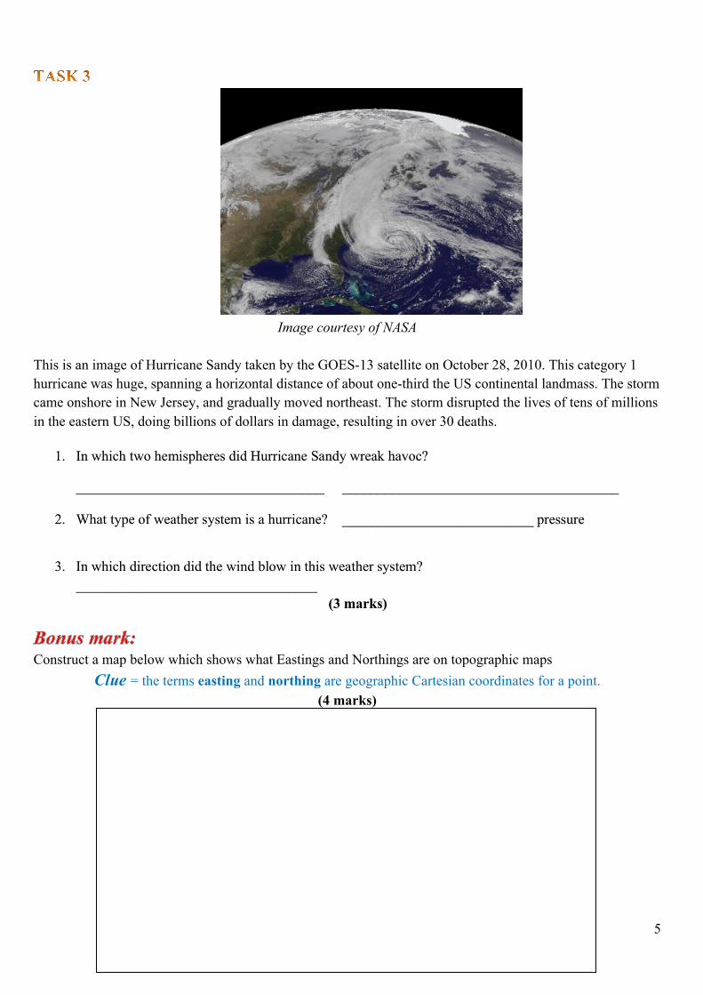
Image courtesy of NASA This is an image of Hurricane Sandy taken by the GOES-13 satellite on October 28, 2010. This category 1 hurricane was huge, spanning a horizontal distance of about one-third the US continental landmass. The storm came onshore in New Jersey, and gradually moved northeast. The storm disrupted the lives of tens of millions in the eastern US, doing billions of dollars in damage, resulting in over 30 deaths.
1. In which two hemispheres did Hurricane Sandy wreak havoc?
___________________________________ _______________________________________
2. What type of weather system is a hurricane? ___________________________ pressure
3. In which direction did the wind blow in this weather system?
__________________________________ (3 marks)
Construct a map below which shows what Eastings and Northings are on topographic maps Clue = the terms easting and northing are geographic Cartesian coordinates for a point.
(4 marks)

6
With reference to the diagram below explain in a few lines what GIS mapping can achieve.
________________________________________________________________________________________
________________________________________________________________________________________
________________________________________________________________________________________
________________________________________________________________________________________
________________________________________________________________________________________
________________________________________________________________________________________
________________________________________________________________________________________
________________________________________________________________________________________
________________________________________________________________________________________
________________________________________________________________________________________
________________________________________________________________________________________
________________________________________________________________________________________
(6 Marks)

7
Going on a world trip
1. What ocean lies between Africa and the Americas?
2. What ocean lies between Asia and the Americas?
3. What is the name of the ocean at the North Pole?
4. What is the name of the continent at the South Pole?
5. What is the name of the ocean that surrounds Antarctica?
6. What ocean borders Africa to the east?
7. What continent is bordered by the Indian Ocean (to the west) and the Pacific Ocean (to the east)?
8. Which two continents are part of one huge land mass (they are separated by a chain of mountains)?
9. If you wanted to travel from Antarctica to the equator, in which direction would you head?
10. What is the name of the imaginary line that is halfway between the poles?
Question Answer 1
2
3
4
5
6
7
8 and
9
10
(10 Marks)
Name the seven continents on Earth in descending order of area size (largest in area size first to smallest last). _____________________________ ______________________________ _______________________ _____________________________ ______________________________ _______________________ _____________________________ (4 marks)

8
- Taking an Australian journey (Complete answers in the table provided on the next page)
1. Start at the Australian city on the Swan River.
2. Travel to the most famous wine region to the south of the city mentioned above.
3. Travel to the islands where the Dutch ship Batavia was wrecked on 4th July 1629.
4. Name the town situated on Roebuck Bay.
5. Move into the Kimberley’s to the mountain range named after a king of Belgium.
6. Continue east to an island named by Dutch explorer, Abel Tasman, in 1644. The name means, Great Island.
7. Continue south to the highest point in the state.
8. Travel to Queensland and alight at an island that James Cook named, as he thought it caused its compass to produce a false reading.
9. Continue to the town that lies on both the Fitzroy River and the Tropic of Capricorn and has a population of about 60,000 people.
10. Move onto the largest sand island in the world.
11. Catch the sunrise at the most easterly point on the Australian mainland.
12. Travel to the city that is situated on a river that was named after the second Governor of NSW (1795-1800).
13. Travel south to the city that has the suburbs of Manuka, Deakin, Belconnen, Barton and Parkes.
14. Travel onto Australia’s highest peak.
15. And down the river, whose waters were diverted inland to ‘turn the desert into Eden’.
16. Travel along the river to the sea and then west then onto the island that is famous for its daily parade of Eudyptula minor.
17. Continue to the coastal town that has both a deep water port and the Alcoa aluminium smelter.
18. Continue your journey to the inland city that was the westernmost city of the Golden Triangle of the Victorian gold rush.
19. Move south en route to Tasmania and pick up some world-famous dairy products for lunch from this island.
20. Head off to the highest point in Tasmania.

9
Question Answer
1
2
3
4
5
6
7
8
9
10
11
12
13
14
15
16
17
18
19
20
(20 marks)
–
Name any four oceans on Earth? _________________________, _________________________,
_________________________, and _________________________.
(4 Marks)

10
Use the contour map below to answer the questions and write the answers into the table provided on page 11.
1. What is the height at Whethertop?
2. What is the height at Gardale Fell?
3. What is the height at Fernside?
4. What is the height at the highest of the Old mines?
5. What height is Top Farm?
6. Where will the steepest hillside be?
7. Where is the place with the lowest height on the map?
8. What height is the source of Top Beck River (where it starts)?
11
Question Answer
1
2
3
4
5
6
7
8
(8 marks)
From the Coordinates listed below, use the provided World Map to identify the Country and the Capital City.
Coordinates Country Capital City
1 32°17′ N, 64° 47′ W Bermuda Hamilton
2 33° 27′ S, 70° 40′ W Chile Santiago
3 51° 42′ S, 57° 51′ W Falkland Islands Stanley
4 35° 40′ N, 51° 25′ E Iran Tehran
5 55° 45′ N, 37° 35′ E Russia Moscow
(10 marks)

12
World Map