Embed Size (px)
Citation preview
Task developed Wayne Inwood, Knox Grammar, 2013
Northern NSW da Vinci Decathlon
SAMPLE An academic gala day
for Years 5 and 6
Cartography
“When you’re a cartographer, having to make maps sort of comes with the territory.” ― Jarod Kintz, A Zebra is the Piano of the Animal Kingdom
Session 2
Team Number _____________

2
Background Information Leonardo da Vinci understood the power of colour to cartography. He was one of the first artists to use colour for strategic mapping.
AN EXAMPLE OF LEONARDO DA VINCI’S CARTOGRAPHY WORK!
LEONARDO DA VINCI’S MAP FOR THE TOWNOF IMOLA, ITALY -
YEAR: 1502
LEONARDO’S AGE: 50
Leonardo created a map of Cesare Borgia’s stronghold, a town plan of Imola in order to win his patronage. When presenting it to Cesare, the powerful leader must have been left in a state of awe. People at the time had hardly heard of maps let alone seen one. Maps themselves held a magical feel to them at the time as it would
have seemed as if one was holding a piece of land in the palm of their hands! Cesare hired Leonardo upon seeing the map as his chief military engineer/ architect.
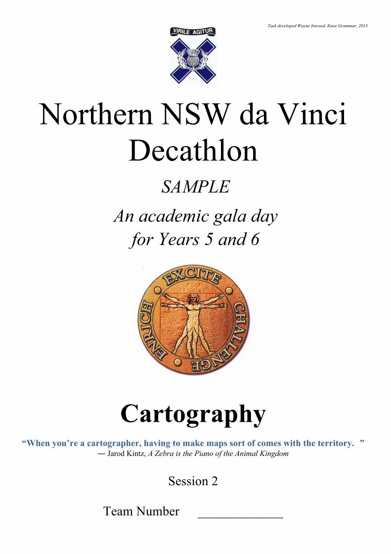
The use of colours on maps to show like features has been used for many centuries. The coloured maps in Cartography are called Choropleth maps. Your task is to produce a choropleth map based on average levels of rainfall in Australia and then to interpret this map
Thematerialsneededforthistaskarecolouredpencilsandapen.
Choropleth mapping uses darker and lighter shades of the one colour group to reveal a pattern. The lightest shade represents the least or weakest presence of a certain element, while the darkest shade signifies the most or strongest presence. The map on the next page shows a coded outline of Australia’s average rainfall pattern during January. Your task is to convert it into a choropleth map by colouring it properly.
3
(6 Marks for map creation and accuracy)
Study your created choropleth map. Does this choropleth map help you quickly see a pattern? What is this pattern? (4 Marks) ________________________________________________________________________________________
________________________________________________________________________________________
________________________________________________________________________________________
________________________________________________________________________________________
________________________________________________________________________________________
What is the approximate distance from the southernmost point of the southernmost state to the northernmost point of the northernmost state? (1 Mark)
_____________________________________ KMs

4
Label the Latitude and Longitude Using the terms below label latitudes and longitudes on the world map.
90º N 45º N 0º Latitude 45º S 90º S
180º W 135º W 90º W 45º W 0º Longitude
45º E 90º E 135º E 180º E
(14 marks)
– link the correct cartographer to the map projection
Map A Map B Map C
Choice of Cartographers = Peter’s, Mollweide or Mercator Map A = Map B = Map C =
(6 marks)

5
Map Outline
1. The capital of Australia is located within the Australian Capital Territory (ACT). What is the capital city?
2. ACT is located within which Australian state?
3. What ocean borders Australia to the west?
4. What is the name of the enormous coral reef off the coast of Queensland?
5. What is the name of the Australian island/state off the southeast coast of the mainland?
6. A huge sandstone monolith is located in the desert interior of Australia, in the Northern Territory. It is a sacred aboriginal site and a world-famous landmark. What is it called?
7. In which part of Australia is Darwin located (northeast, west, etc.)?
8. The Great Australian Bight is an open bay. Is it off the north, south, east, or west coast of Australia?
9. If you wanted to travel from Perth to Alice Springs, in which direction would you head?
10. Roughly how many km is it from Canberra to Melbourne: 5 km, 50 km, 500 km, 5,000 km, or 50,000 km?
(Table for answers is on next page)
Scale: 1cm : 250 kms

6
Question Answer 1
2
3
4
5
6
7
8
9
10
(10 Marks)
Country Anagrams An anagram is a word that is made by rearranging the letters of another word.
For example, acrimonies is an anagram of Micronesia. For each word, write an anagram for it that is a country name.
(9 Marks)


![ARMIDALE CITY PUBLIC SCHOOL SESQUICENTENARY · ARMIDALE CITY PUBLIC SCHOOL SESQUICENTENARY ... Kaye (Mrs) 1974? ... See also DEZIUS,Carol (Mrs)] HEAD,](https://img.pdfslide.net/doc/110x75/5b00e39e7f8b9a84338d50b6/armidale-city-public-school-city-public-school-sesquicentenary-kaye-mrs-1974.jpg)