Embed Size (px)
Citation preview
Northern Turnpike Corridor
Fanning Springs, Florida
February 12, 2020
Sunshine Law Video
Task Force Meeting #4
February 12, 2020


Public Input
Task Force Meeting #4
February 12, 2020
Your Voice Is ImportantInput Summary

Community Engagement
10101010Sumter CountySumter CountySumter CountySumter County
December 19, 2019
177177177177Levy CountyLevy CountyLevy CountyLevy County
January 28, 2020
129129129129Citrus CountyCitrus CountyCitrus CountyCitrus County
January 30, 2020
We welcomed more than 300 members of the public toWe welcomed more than 300 members of the public toWe welcomed more than 300 members of the public toWe welcomed more than 300 members of the public to
Community Open House Events since we last met in December.Community Open House Events since we last met in December.Community Open House Events since we last met in December.Community Open House Events since we last met in December.
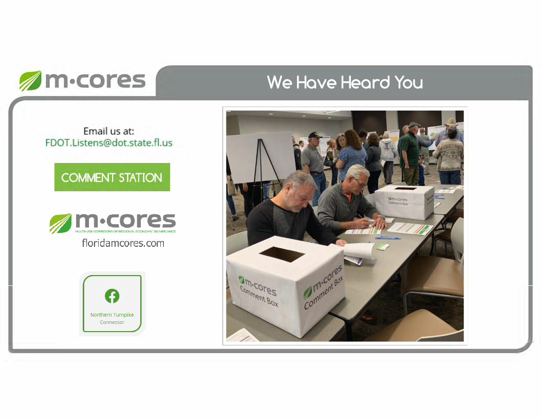
We Have Heard You
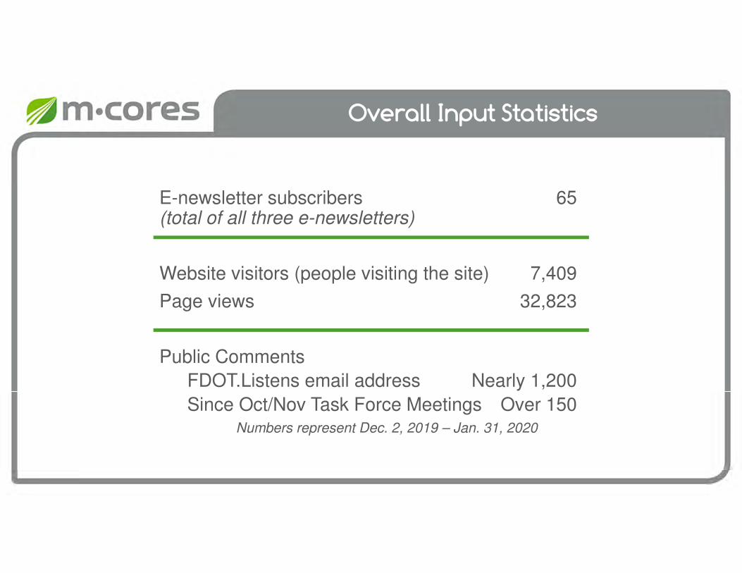
Overall Input Statistics
E-newsletter subscribers 65(total of all three e-newsletters)
Website visitors (people visiting the site) 7,409
Page views 32,823
Public Comments
FDOT.Listens email address Nearly 1,200
Since Oct/Nov Task Force Meetings Over 150Numbers represent Dec. 2, 2019 – Jan. 31, 2020

Overall Input Statistics
M-CORES Web Mapping ApplicationView Counts
M-CORES Northern Turnpike Corridor 1,282Average Daily View Count 21.37
M-CORES Southwest-Central Corridor 1,511Average Daily View Count 25.18
M-CORES Suncoast Corridor 2,135Average Daily View Count 35.58
Numbers represent Dec. 2, 2019 – Jan. 31, 2020

Staying Engaged
OneOneOneOne----OOOOnnnn----OOOOne ne ne ne MMMMeetingseetingseetingseetings, , , , PresentationsPresentationsPresentationsPresentations
and and and and PPPPhonehonehonehone CCCConversationonversationonversationonversationssss
• Task Force Members
• Local Agencies
Updating the PublicUpdating the PublicUpdating the PublicUpdating the Public
• Social Media
• Sign up for e-newsletters at FloridaMCORES.com
Workshops Workshops Workshops Workshops
AvailableAvailableAvailableAvailable
Request through

Next Steps for Engagement
Task Force Meeting #5
• March 25Hilton Ocala3600 SW 36th AvenueOcala, FL 34474
Community Open House
• March 26College of Central Florida –Levy Campus15390 NW Hwy 19Chiefland, FL 32626

Workforce Development
Task Force Meeting #4
February 12, 2020
Current Work Program
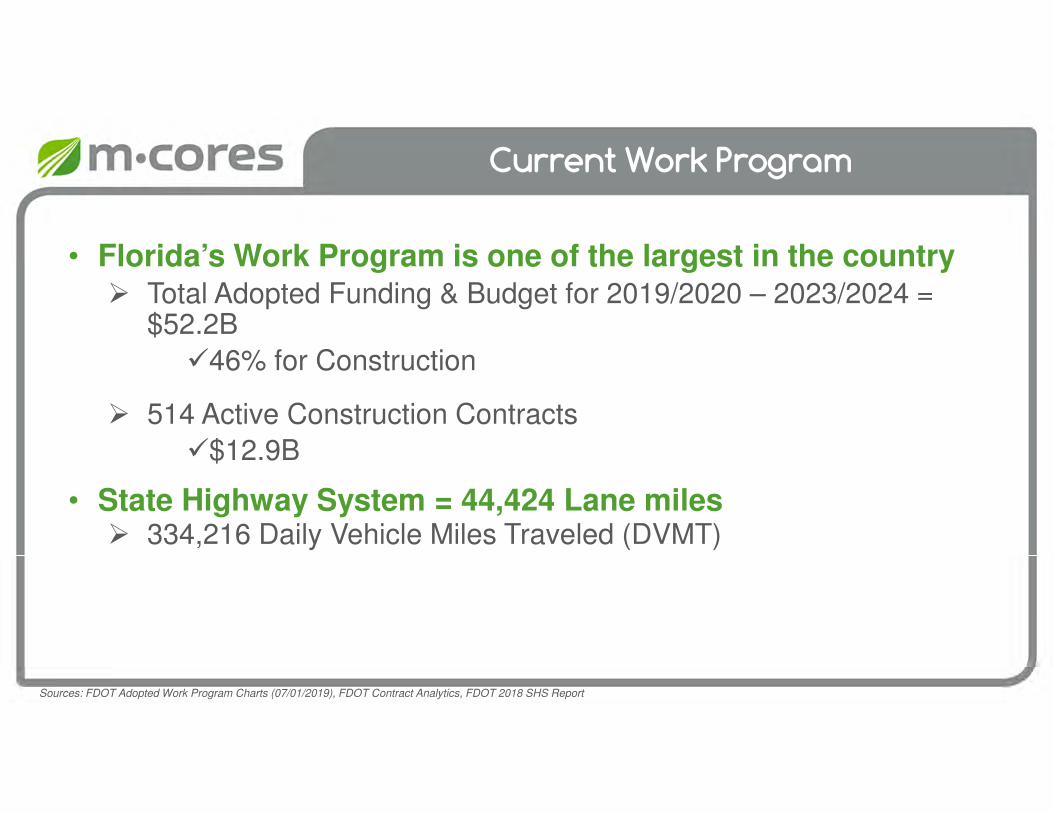
• Florida’s Work Program is one of the largest in the country Total Adopted Funding & Budget for 2019/2020 – 2023/2024 =
$52.2B
46% for Construction
514 Active Construction Contracts
$12.9B
• State Highway System = 44,424 Lane miles 334,216 Daily Vehicle Miles Traveled (DVMT)
Sources: FDOT Adopted Work Program Charts (07/01/2019), FDOT Contract Analytics, FDOT 2018 SHS Report
Population Growth Projections
Source: U.S. Census Bureau; University of Florida Geo Plan, 1000 Friends of Florida, Florida Department of Agriculture, U-Haul, Visit Florida, Florida Chamber of Commerce
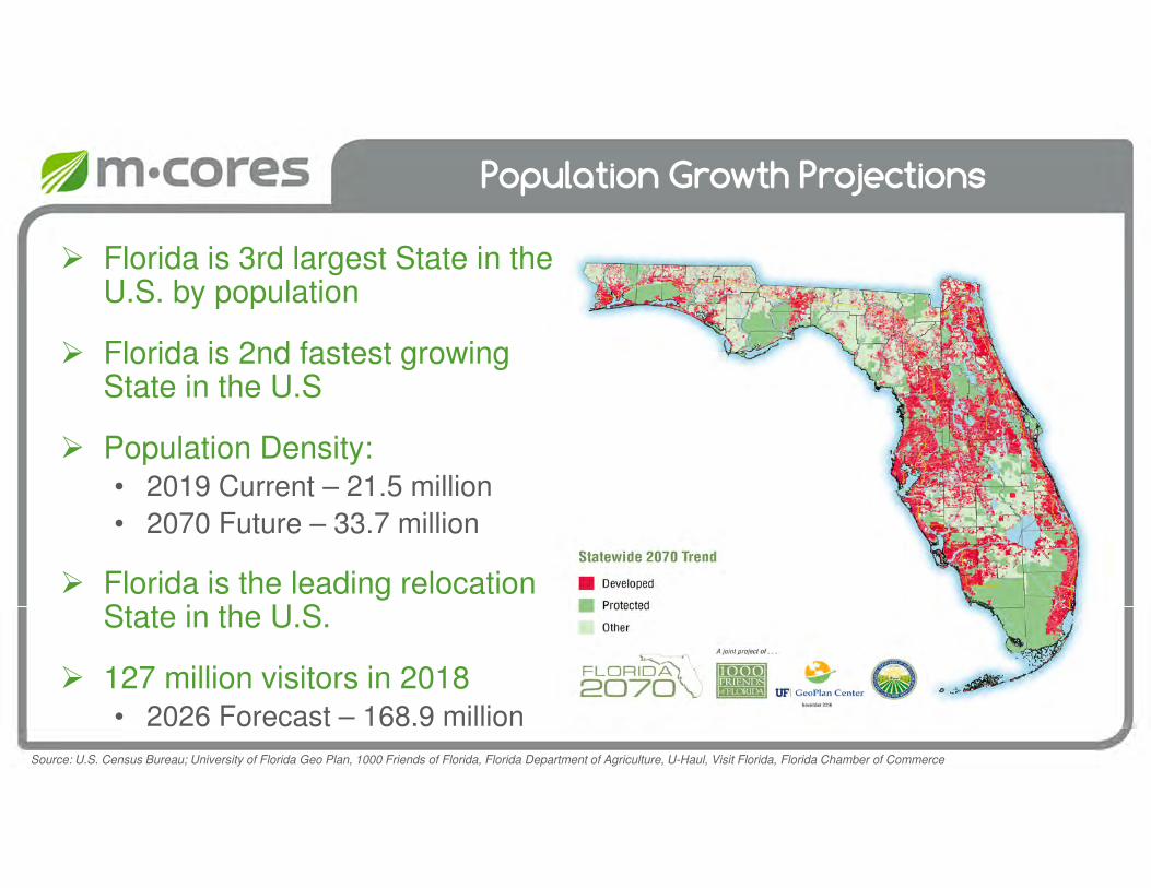
Florida is 3rd largest State in the U.S. by population
Florida is 2nd fastest growing State in the U.S
Population Density:• 2019 Current – 21.5 million
• 2070 Future – 33.7 million
Florida is the leading relocation State in the U.S.
127 million visitors in 2018• 2026 Forecast – 168.9 million
0.0%
0.5%
1.0%
1.5%
2.0%
2.5%
3.0%
3.5%
4.0%
4.5%
5.0%
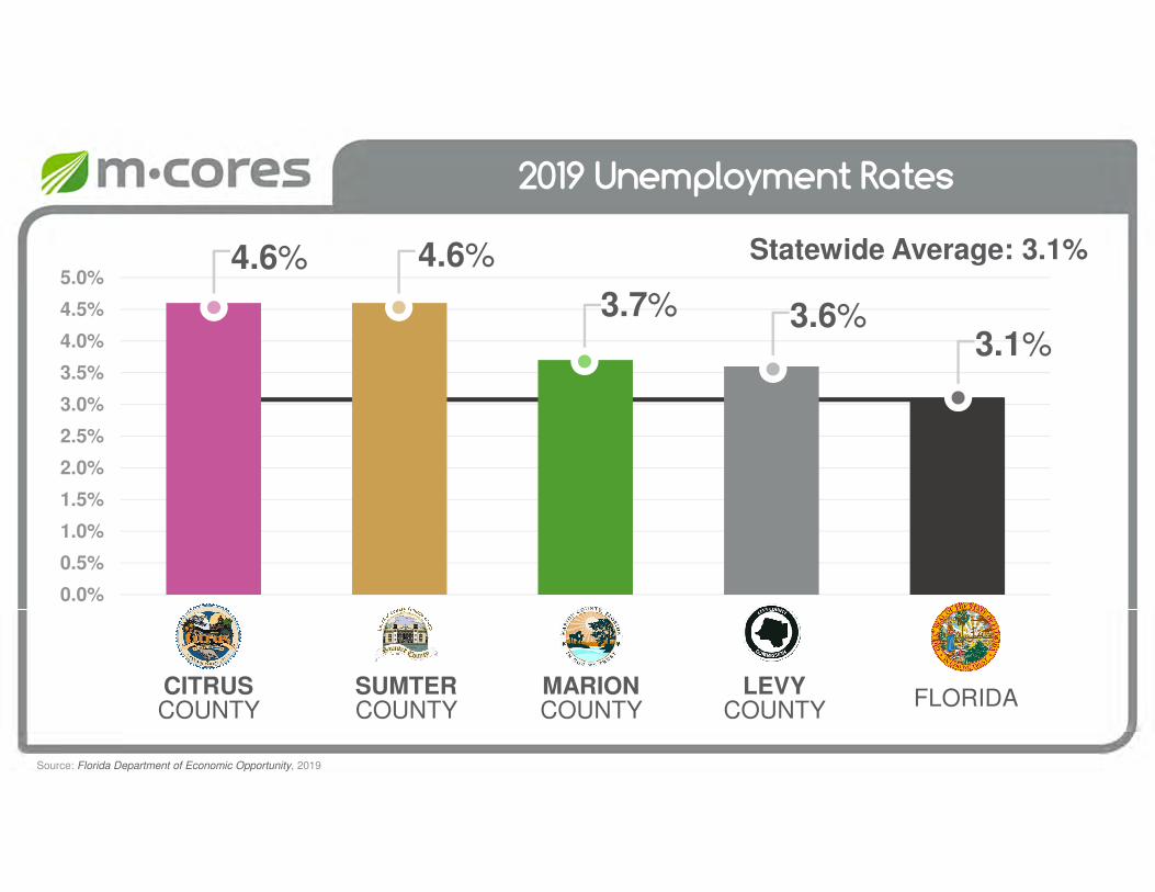
2019 Unemployment Rates
4.6%
3.7% 3.6%
4.6%
LEVYCOUNTY
SUMTERCOUNTY
CITRUSCOUNTY
MARIONCOUNTY
FLORIDA
3.1%
Source: Florida Department of Economic Opportunity, 2019
Statewide Average: 3.1%

Employment by Industry
0 5,000 10,000 15,000 20,000 25,000 30,000 35,000 40,000
Health Care & Social Assistance
Retail Trade
Government & Government Enterprise
Accommodation & Food Services
Construction
Industry Employment
Source: Bureau of Economic Analysis, 2019
Florida Statutes 334.044 & 338.2278
F.S. Section 334.044(35) – Duties of the department
To provide a road and bridge construction workforce development program, in consultation with affected stakeholders, for construction of projects designated in the department’s work program
The workforce development program is intended to provide direct economic benefits to communities in which the department is constructing
infrastructure projects and to promote employment opportunities, including within areas of low income and high unemployment
The department shall merge any of its own existing workforce services into the program to create a robust workforce development program. The workforce development program must serve as a tool to address the construction
labor shortage by recruiting and developing a group of skilled workers for infrastructure projects to increase the likelihood of department projects remaining on time and within budget
Florida Statutes 334.044 & 338.2278
F.S. Section 334.044(35) – Duties of the department (Cont.)
To accomplish these activities, the department may administer workforce development contracts with consultants and nonprofit entities, such as local community partners, Florida College System institutions, and technical institutions or centers
The department shall develop performance and outcome metrics to ensure accountability and to measure the benefits and cost-effectiveness of the program. By June 30, 2020, and annually thereafter, the department shall prepare and provide a report to the Governor, President of Senate, and Speaker of the House of Representatives detailing the results of its findings and containing any recommendations relating to future program refinements.
F.S. Section 338.2278(8) – Multi-use Corridors of Regional Economic Significance Program
FY 2019-2020, 2020-2021, 2021-2022
For “Workforce development program, $2.5 million, to be used as specified in s. 334.044(35)”
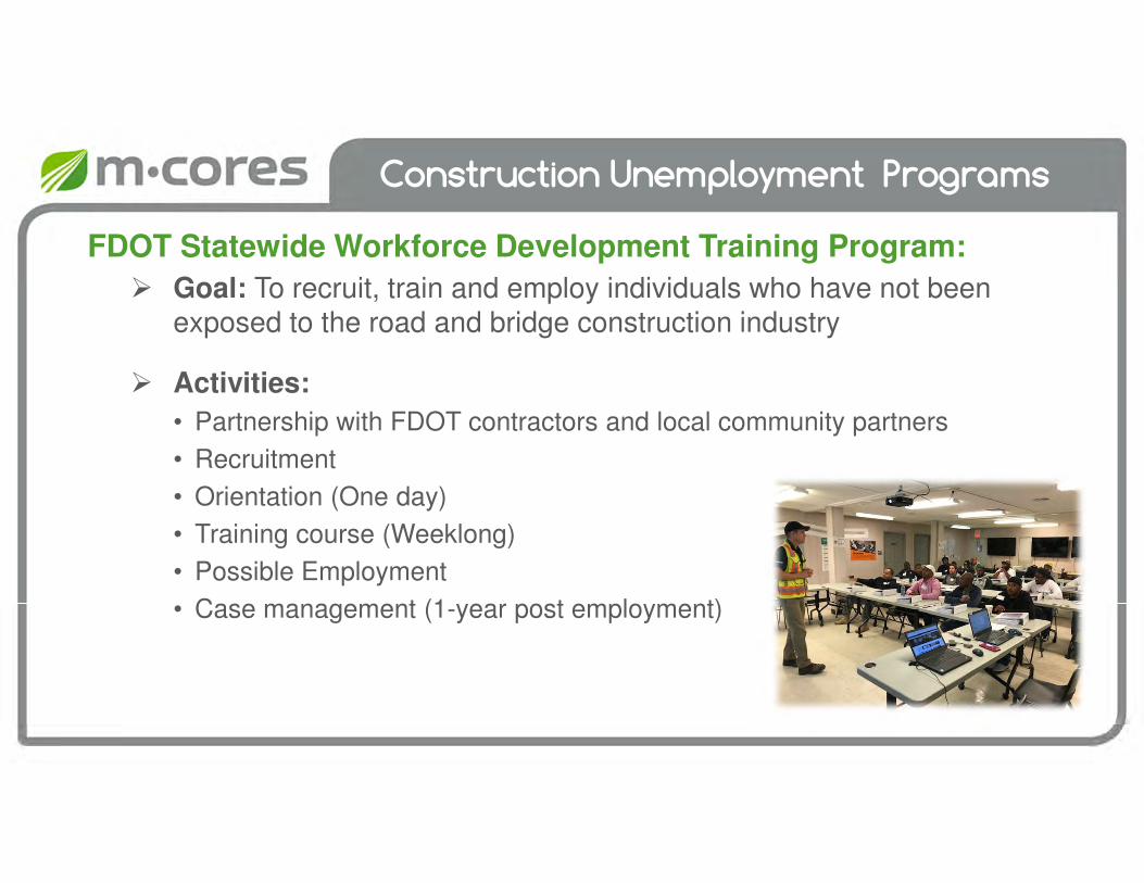
Construction Unemployment Programs
FDOT Statewide Workforce Development Training Program:
Goal: To recruit, train and employ individuals who have not been exposed to the road and bridge construction industry
Activities:
• Partnership with FDOT contractors and local community partners
• Recruitment
• Orientation (One day)
• Training course (Weeklong)
• Possible Employment
• Case management (1-year post employment)
Construction Unemployment Programs
ONBOARD4JOBS:
Goal: Help job seekers gain employment on road and bridge construction projects with local contractors and increase the number of minorities, females and veterans on road and bridge construction contracts
Activities:
• Hiring Fairs
• Online Job Opportunities
Construction Unemployment Programs
Under Development:
Prison Inmate Transition Program
• Conceptual Goal: To transition released prison inmates from the correctional system into road and bridge construction jobs
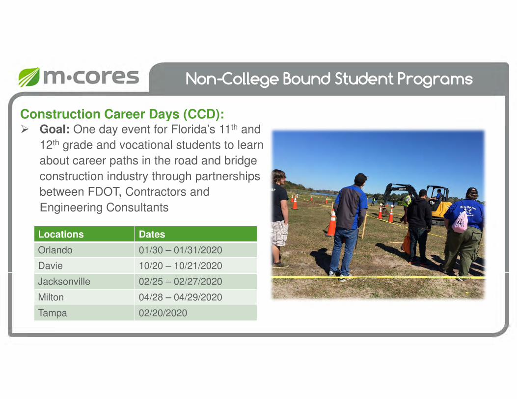
Non-College Bound Student Programs
Construction Career Days (CCD): Goal: One day event for Florida’s 11th and
12th grade and vocational students to learn
about career paths in the road and bridge
construction industry through partnerships
between FDOT, Contractors and
Engineering Consultants
Locations Dates
Orlando 01/30 – 01/31/2020
Davie 10/20 – 10/21/2020
Jacksonville 02/25 – 02/27/2020
Milton 04/28 – 04/29/2020
Tampa 02/20/2020
Non-College Bound Student Programs
Under Development: Summer Youth Internship Program
• Conceptual Goal: To provide a 4 to 6-week part-time hands on internship to Florida’s 11th and 12th grade and vocational students, with a local contractor, on a FDOT construction project
Construction Career Academy• Conceptual Goal: To provide a one-day academy for Florida’s
11th and 12th grade and vocational students to provide a more in-depth exposure to career paths in the road and bridge construction industry

Break
floridamcores.com

Panel Discussion
Task Force Meeting #4
February 12, 2020
Local Government Comprehensive Plans and Regional and Community Visions
Task Force Meeting #4
February 12, 2020
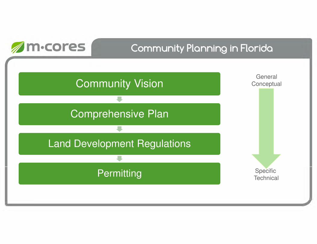
Community Planning in Florida
Community Vision
Comprehensive Plan
Land Development Regulations
Permitting
GeneralConceptual
Specific Technical
Comprehensive Plans
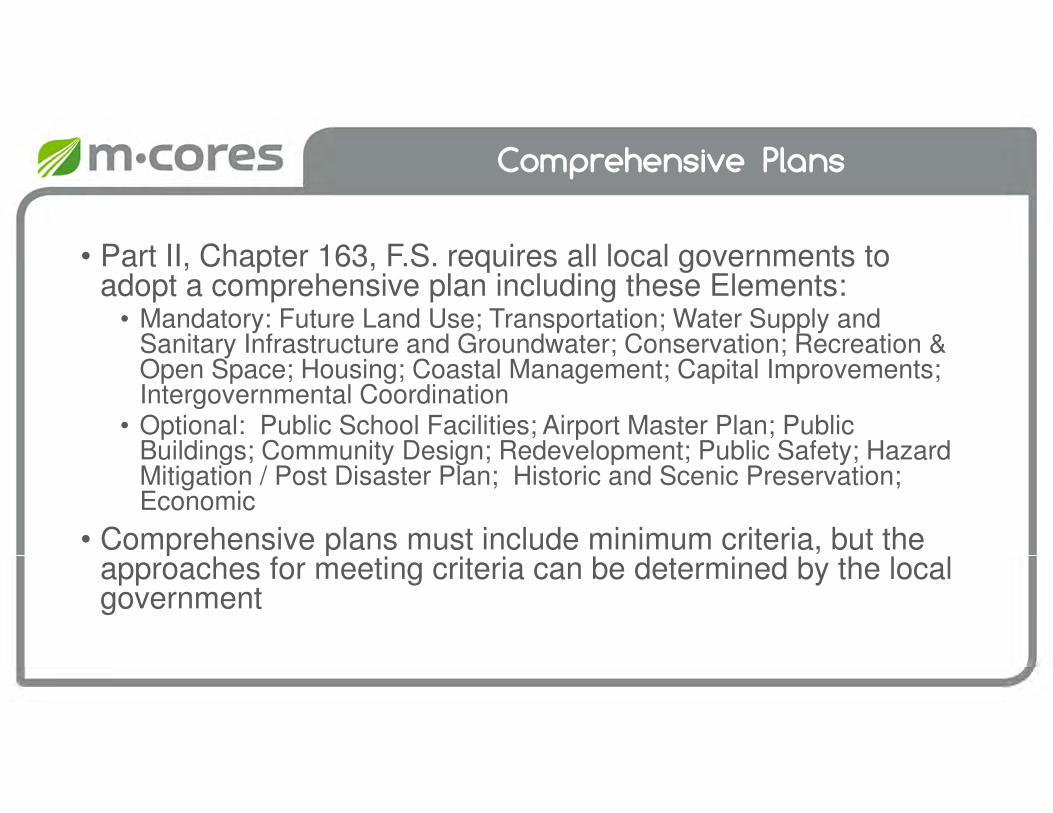
• Part II, Chapter 163, F.S. requires all local governments to adopt a comprehensive plan including these Elements:
• Mandatory: Future Land Use; Transportation; Water Supply and Sanitary Infrastructure and Groundwater; Conservation; Recreation & Open Space; Housing; Coastal Management; Capital Improvements; Intergovernmental Coordination
• Optional: Public School Facilities; Airport Master Plan; Public Buildings; Community Design; Redevelopment; Public Safety; Hazard Mitigation / Post Disaster Plan; Historic and Scenic Preservation; Economic
• Comprehensive plans must include minimum criteria, but the approaches for meeting criteria can be determined by the local government

Comprehensive Plans and Corridor Plans
• F.S. Section 337.273• The designation and management of transportation corridors can best be
achieved through the inclusion of transportation corridors in the local government comprehensive plans….in order to ensure comprehensive planning for future development and growth…
• F.S. Section 338.2278• Not later than December 31, 2023, a local government that has an
interchange within its jurisdiction shall review the applicable task force report and its local comprehensive plan …The local government review must include consideration of whether the area in and around the interchange contains appropriate land uses and natural resource protections and whether the comprehensive plan should be amended to provide such appropriate uses and protections.
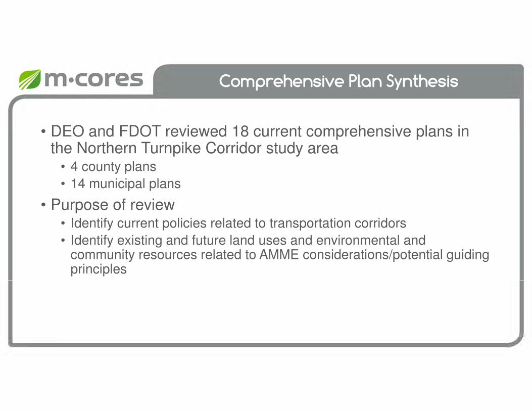
Comprehensive Plan Synthesis
• DEO and FDOT reviewed 18 current comprehensive plans in the Northern Turnpike Corridor study area
• 4 county plans
• 14 municipal plans
• Purpose of review• Identify current policies related to transportation corridors
• Identify existing and future land uses and environmental and community resources related to AMME considerations/potential guiding principles

Comprehensive Plan Synthesis
County
Comprehensive Plan Future Land Use Map
Year Adopted/Updated
Horizon YearYear
Adopted/UpdatedHorizon Year
Citrus 2017 2030 2018 2030
Levy 2017 2026 2017 2026
Marion1 2019 2045 2019 2045
Sumter2 2019 2035 2019 2035
County Comprehensive Plans and Future Land Use Maps
1Town of McIntosh uses Marion County Plan
2Includes City of Center Hill, City of Coleman and City of Webster

Comprehensive Plan Synthesis
County City/Town
Comprehensive Plan Future Land Use Map
Year Adopted/Updated Horizon Year Year Adopted/Updated Horizon Year
CitrusCity of Crystal River 2011 2025 2019 2025
City of Inverness 2016 2020 2016 2026
Levy
Town of Bronson 1990 2000 1990 2000
City of Chiefland 2018 2028 2018 2028
City of Fanning Springs 2015 2025 2015 2025
Town of Inglis 2010/2019 2029 2010/2015 2029
Town of Yankeetown 2012 2022 2011 2022
City of Williston 2018 2030 2018 2030
Marion
City of Belleview 2015 2035 2014 2035
City of Dunnellon 2016 2035 2015 2035
City of Ocala 2014 2035 2011 2035
Town of Reddick 2011 2022 2011 2022
SumterCity of Bushnell 2011 2035 2011 2035
City of Wildwood 2019 2035 2019 2035
Cities and Towns Comprehensive Plans and Future Land Use Maps
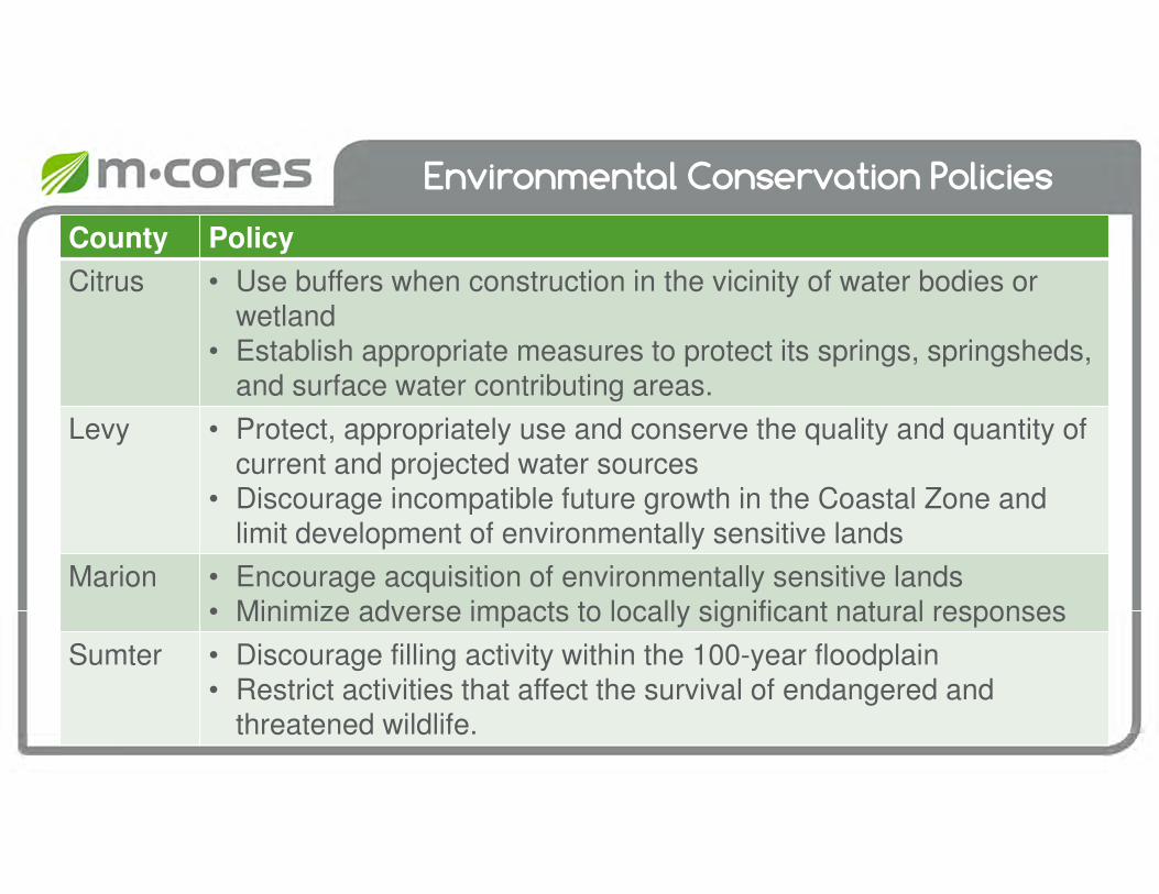
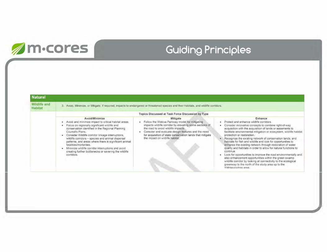
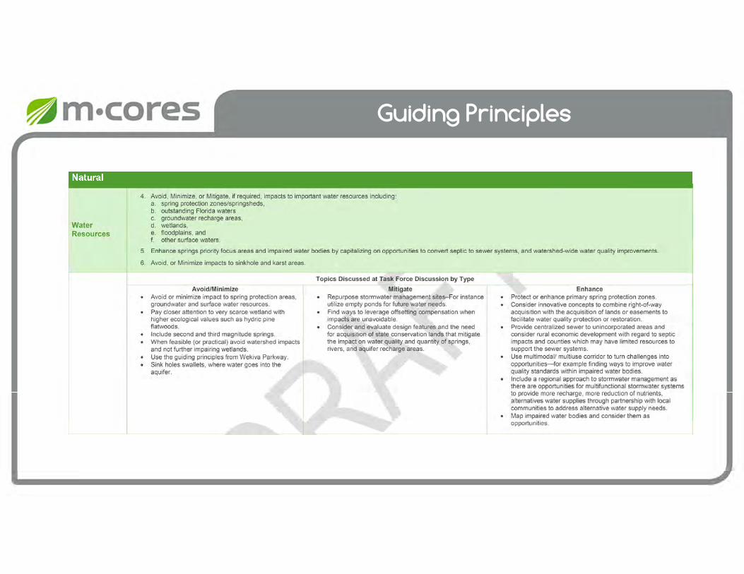
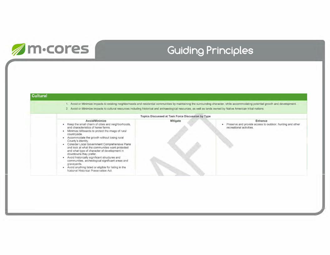
Environmental Conservation Policies
County Policy
Citrus • Use buffers when construction in the vicinity of water bodies or wetland
• Establish appropriate measures to protect its springs, springsheds, and surface water contributing areas.
Levy • Protect, appropriately use and conserve the quality and quantity of current and projected water sources
• Discourage incompatible future growth in the Coastal Zone and limit development of environmentally sensitive lands
Marion • Encourage acquisition of environmentally sensitive lands• Minimize adverse impacts to locally significant natural responses
Sumter • Discourage filling activity within the 100-year floodplain• Restrict activities that affect the survival of endangered and
threatened wildlife.

Farmland Preservation Areas
• Marion County established the Farmland Preservation Area to preserve agriculture and rural character of the area
• Designated as the Horse Capital of the World
• Infrastructure shall reflect rural area
• Context sensitive design
• Avoidance of negative impacts to vital farmlands
• Development of new corridors shall be coordinated with the Board of County Commissioners
Source: Marion County, FDOT, FGDL
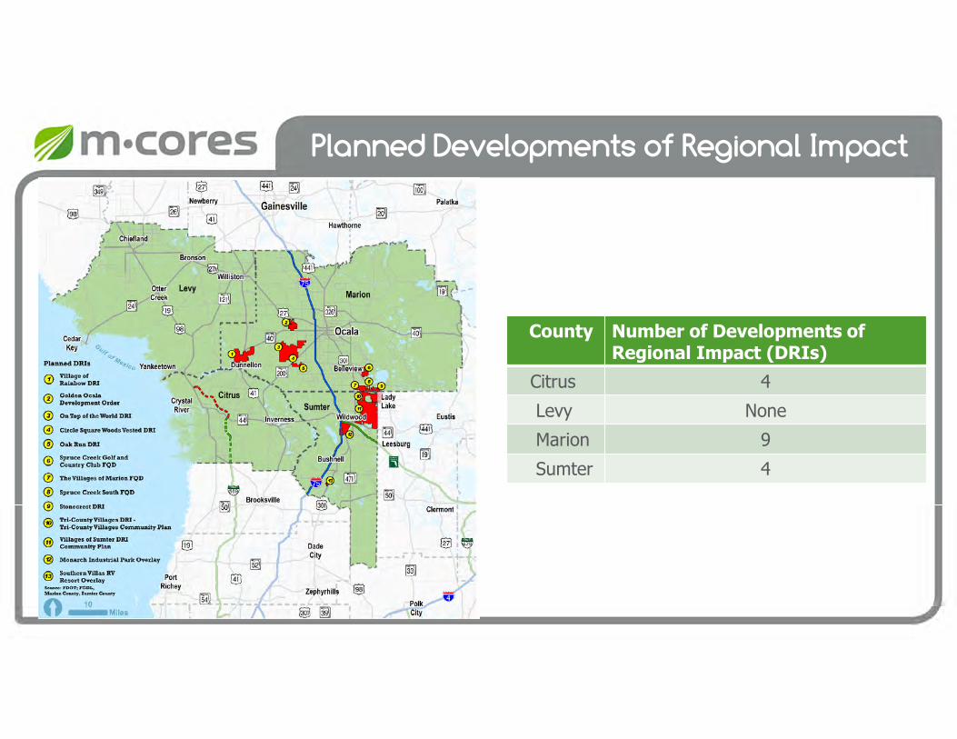
Planned Developments of Regional Impact
County Number of Developments of Regional Impact (DRIs)
Citrus 4
Levy None
Marion 9
Sumter 4
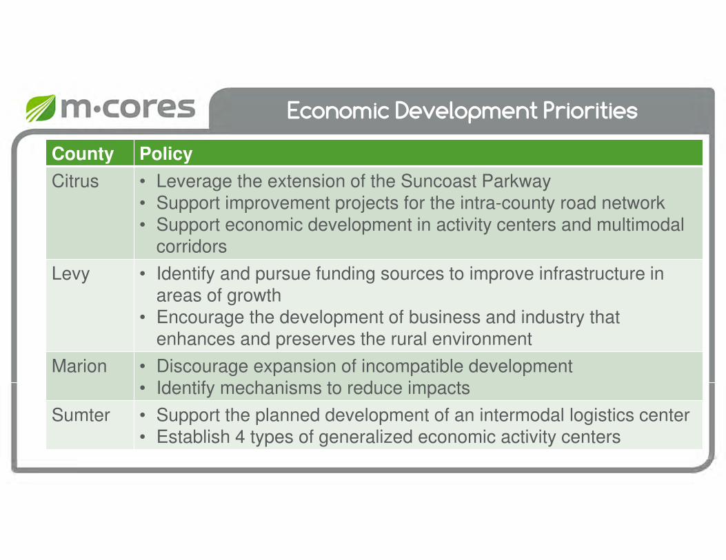
Economic Development Priorities
County Policy
Citrus • Leverage the extension of the Suncoast Parkway • Support improvement projects for the intra-county road network• Support economic development in activity centers and multimodal
corridors
Levy • Identify and pursue funding sources to improve infrastructure in areas of growth
• Encourage the development of business and industry that enhances and preserves the rural environment
Marion • Discourage expansion of incompatible development • Identify mechanisms to reduce impacts
Sumter • Support the planned development of an intermodal logistics center• Establish 4 types of generalized economic activity centers

Future Land Use Map
Citrus County
• Future Land Use Districts
• Future Development Pattern
• Corridor Planning Zones
• Commercial Nodes
• Future Commercial Land Uses
• Interchange Management Areas
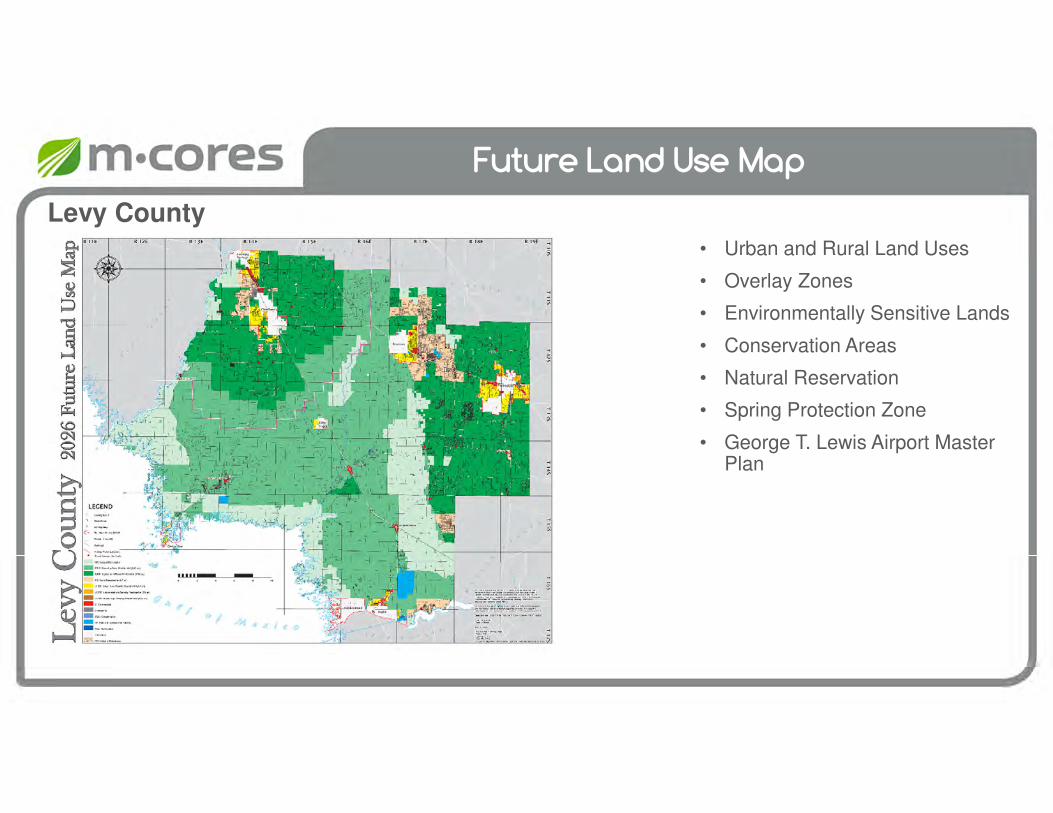
Future Land Use Map
Levy County
• Urban and Rural Land Uses
• Overlay Zones
• Environmentally Sensitive Lands
• Conservation Areas
• Natural Reservation
• Spring Protection Zone
• George T. Lewis Airport Master Plan

Future Land Use Map
Marion County
• Farmland Preservation Area
• On Top of the World Development of Regional Impact
• Urban Growth Boundary
• Preservation Areas
• Environmentally Sensitive Overlay Zone
• Rural Activity Center
• Future Land Use Map Series
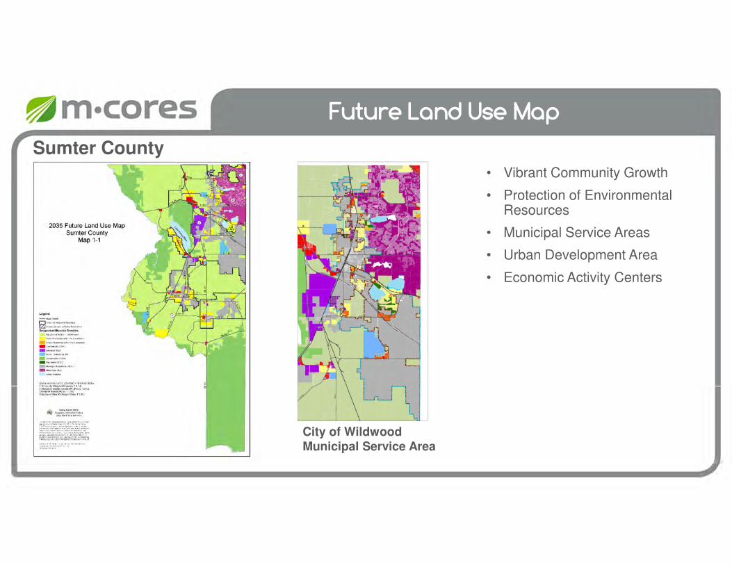
Future Land Use Map
Sumter County
City of Wildwood Municipal Service Area
• Vibrant Community Growth
• Protection of Environmental Resources
• Municipal Service Areas
• Urban Development Area
• Economic Activity Centers

Transportation Element Policies
County Transportation Element
Citrus • Leverage public infrastructure investment to encourage economic development
• Identify and designate multimodal corridors and activity centers • Designate Interchange Management Areas within Suncoast Parkway• Assure compatibility of development and development intensities • Provide the opportunity for use of multimodal transportation options to
serve local and regional movements and connectivity• No new road construction west of US 19• Protection of wetlands and other environmentally sensitive lands
Levy • Identify funding sources to improve infrastructure in areas of growth • Support development of business and industry that enhances
environment
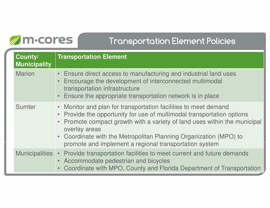
Transportation Element Policies
County/
Municipality
Transportation Element
Marion • Ensure direct access to manufacturing and industrial land uses • Encourage the development of interconnected multimodal
transportation infrastructure• Ensure the appropriate transportation network is in place
Sumter • Monitor and plan for transportation facilities to meet demand• Provide the opportunity for use of multimodal transportation options • Promote compact growth with a variety of land uses within the municipal
overlay areas • Coordinate with the Metropolitan Planning Organization (MPO) to
promote and implement a regional transportation system
Municipalities • Provide transportation facilities to meet current and future demands• Accommodate pedestrian and bicycles• Coordinate with MPO, County and Florida Department of Transportation
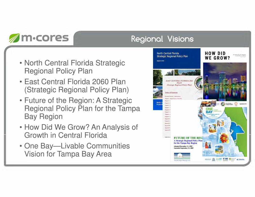
Regional Visions
• North Central Florida Strategic Regional Policy Plan
• East Central Florida 2060 Plan (Strategic Regional Policy Plan)
• Future of the Region: A Strategic Regional Policy Plan for the Tampa Bay Region
• How Did We Grow? An Analysis of Growth in Central Florida
• One Bay—Livable Communities Vision for Tampa Bay Area
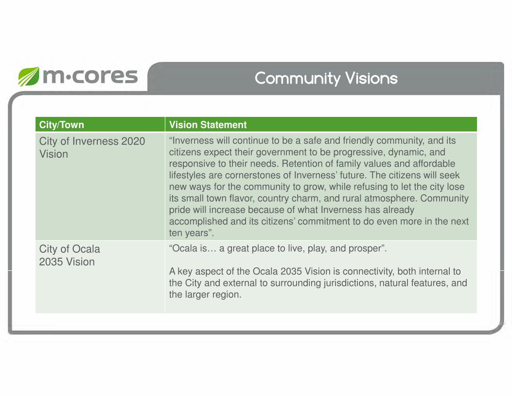
Community Visions
City/Town Vision Statement
City of Inverness 2020 Vision
“Inverness will continue to be a safe and friendly community, and its citizens expect their government to be progressive, dynamic, and responsive to their needs. Retention of family values and affordable lifestyles are cornerstones of Inverness’ future. The citizens will seek new ways for the community to grow, while refusing to let the city lose its small town flavor, country charm, and rural atmosphere. Community pride will increase because of what Inverness has already accomplished and its citizens’ commitment to do even more in the next ten years”.
City of Ocala 2035 Vision
“Ocala is… a great place to live, play, and prosper”.
A key aspect of the Ocala 2035 Vision is connectivity, both internal to the City and external to surrounding jurisdictions, natural features, and the larger region.
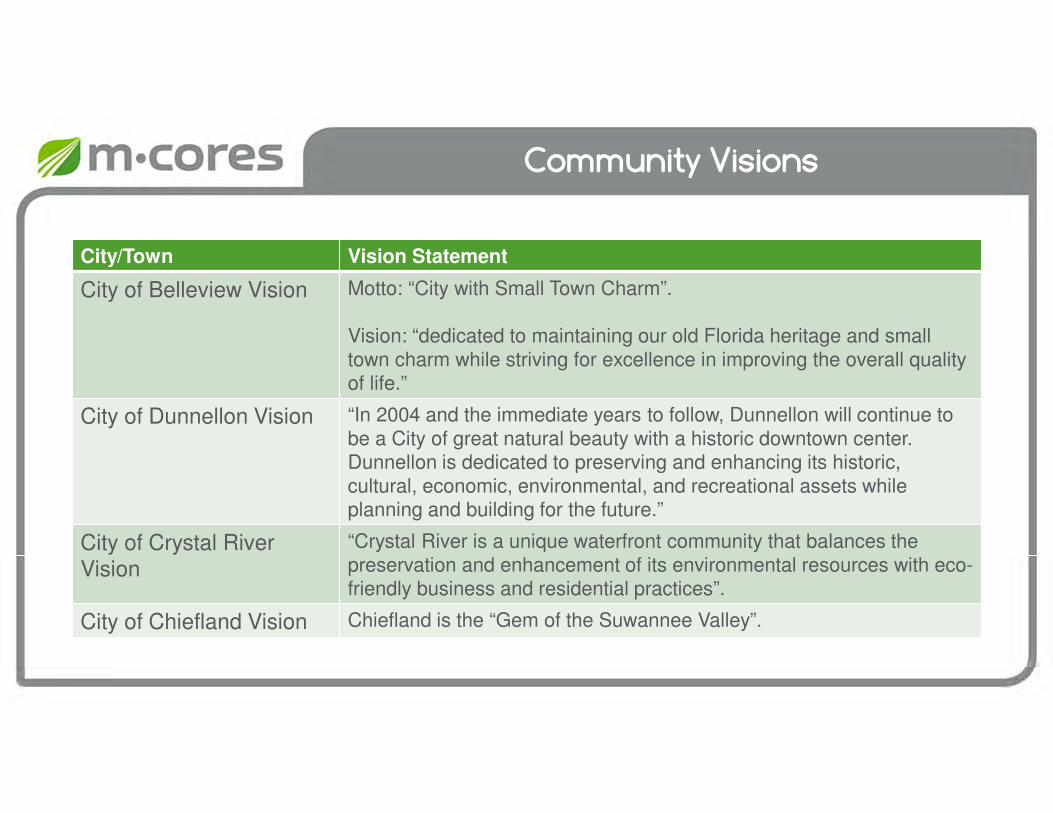
Community Visions
City/Town Vision Statement
City of Belleview Vision Motto: “City with Small Town Charm”.
Vision: “dedicated to maintaining our old Florida heritage and small town charm while striving for excellence in improving the overall quality of life.”
City of Dunnellon Vision “In 2004 and the immediate years to follow, Dunnellon will continue to be a City of great natural beauty with a historic downtown center. Dunnellon is dedicated to preserving and enhancing its historic, cultural, economic, environmental, and recreational assets while planning and building for the future.”
City of Crystal River Vision
“Crystal River is a unique waterfront community that balances the preservation and enhancement of its environmental resources with eco-friendly business and residential practices”.
City of Chiefland Vision Chiefland is the “Gem of the Suwannee Valley”.
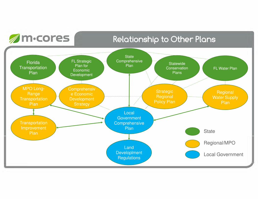
Relationship to Other Plans
Florida Transportation
Plan
FL Strategic Plan for
Economic Development
FL Water Plan
Statewide Conservation
Plans
State Comprehensive
Plan
Land Developlment Regulations
Transportation Improvement
Plan
MPO Long-Range
Transportation Plan
Local Government
Comprehensive Plan
Regional Water Supply
Plan
State
Regional/MPO
Local Government
Strategic Regional
Policy Plan
Comprehensive Economic
Development Strategy
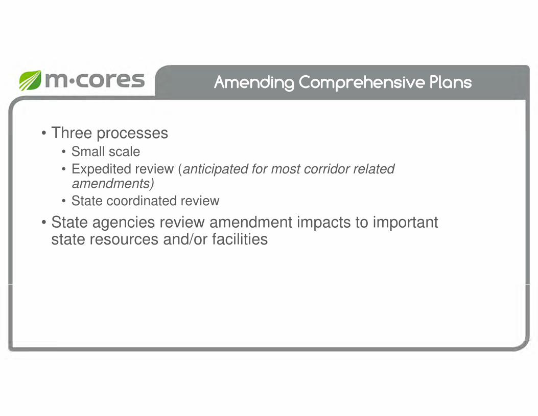
Amending Comprehensive Plans
• Three processes• Small scale
• Expedited review (anticipated for most corridor related amendments)
• State coordinated review
• State agencies review amendment impacts to important state resources and/or facilities
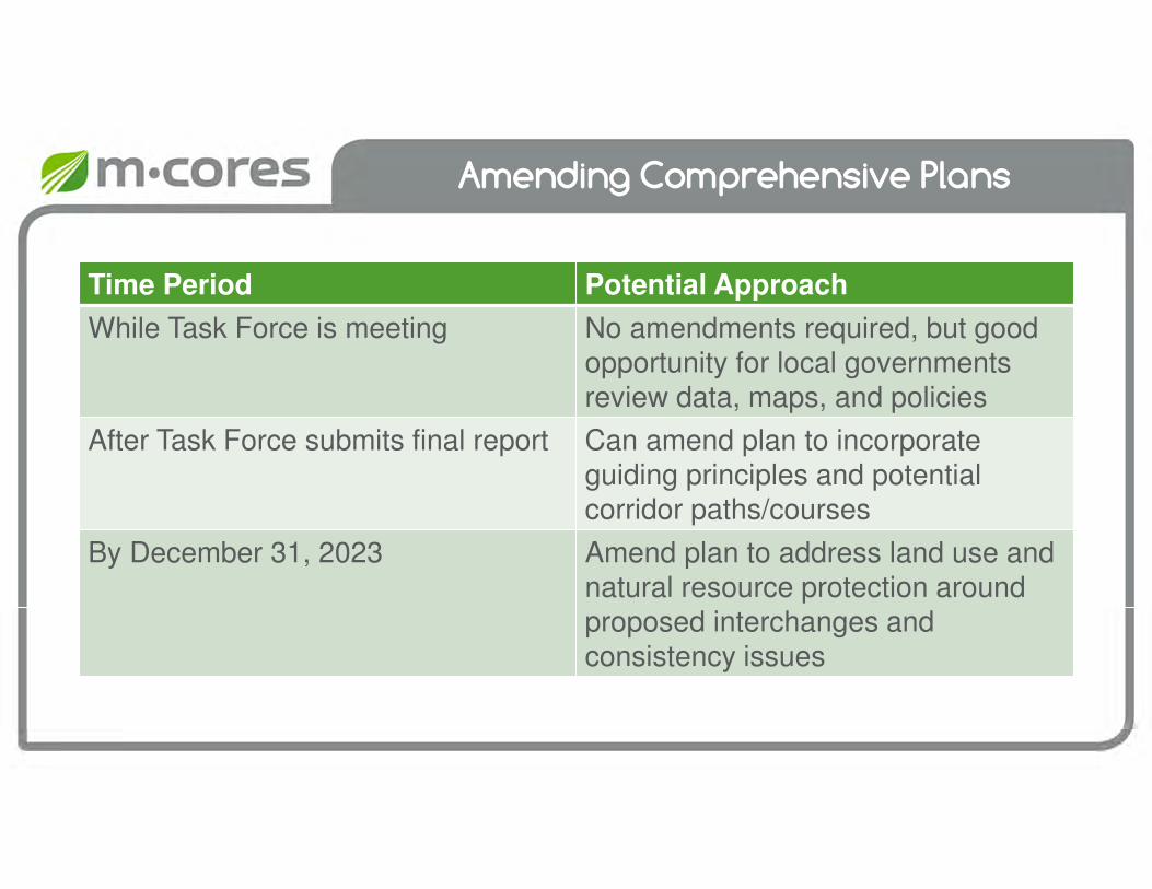
Amending Comprehensive Plans
Time Period Potential Approach
While Task Force is meeting No amendments required, but good opportunity for local governments review data, maps, and policies
After Task Force submits final report Can amend plan to incorporate guiding principles and potential corridor paths/courses
By December 31, 2023 Amend plan to address land use and natural resource protection around proposed interchanges and consistency issues

floridamcores.com
Wekiva Parkway Video
Task Force Meeting #4
February 12, 2020

Existing Modal Infrastructure
Task Force Meeting #4
February 12, 2020

Source: CSX Transportation
Accommodate Multiple Modes
Advance construction of regional corridors intended to accommodate multiple modes of transportation and multiple types of infrastructure
Freight Rail, Wildwood
Source: SunTran
Transit Buses, Ocala
Source: Google Earth
Dunnellon Trail, Dunnellon

Existing Rail Infrastructure
Key System Statistics
1 Strategic Intermodal System (SIS)
Railway Corridor
1 Strategic Growth Railway Corridor
~158 Total track miles
77 At-grade crossings
1 Rail interchange
Purpose/Use
No passenger service
Freight, moving various commodities
~15 Daily train movementsSource: FDOT, FRA, CSXT, Pinkly

Existing Transit Infrastructure
Key System Statistics
704,725 Fixed route revenue miles
43,191 Fixed route revenue hours
3,263,371 Paratransit revenue miles
2,865,335 Paratransit revenue hours
Purpose/Use
95,513 Service areas population
476,577 Annual bus ridership
124,121 Annual demand response
Source: FDOT, CTD, NTD
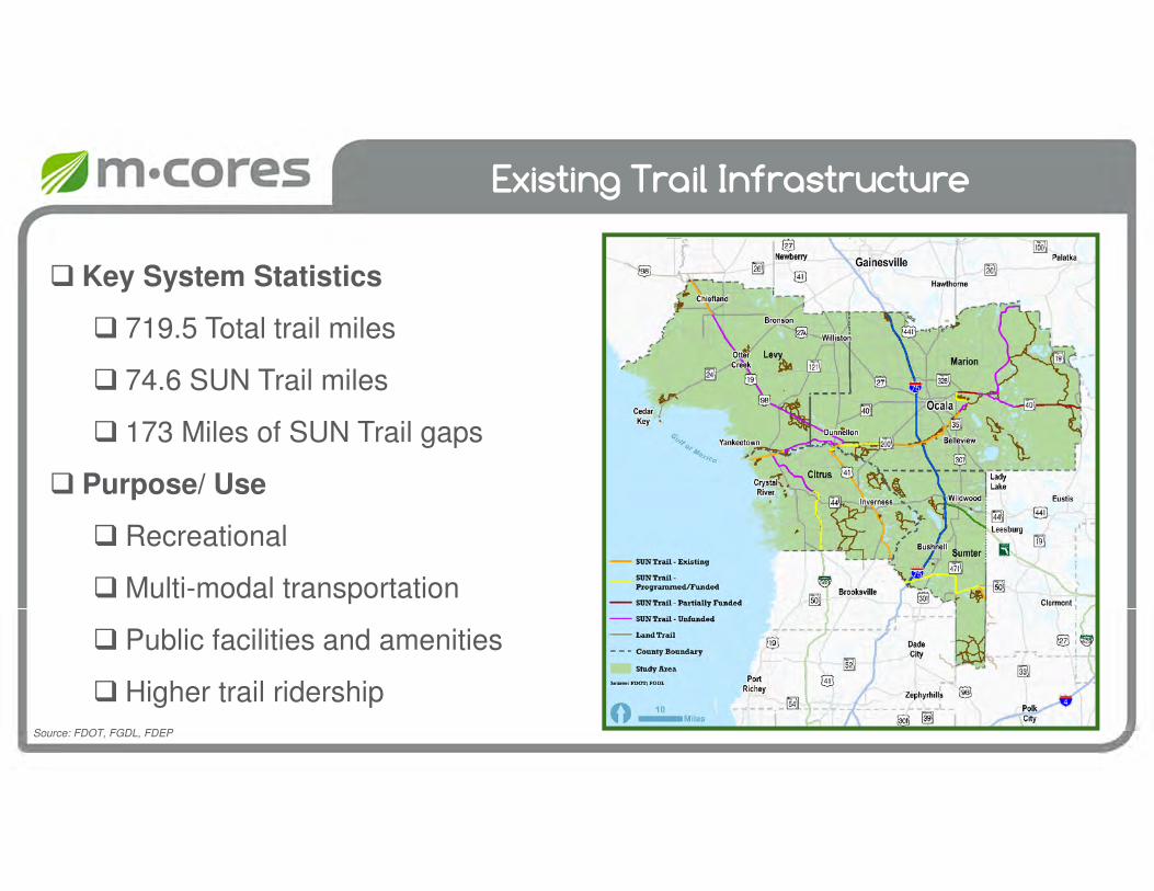
Existing Trail Infrastructure
Key System Statistics
719.5 Total trail miles
74.6 SUN Trail miles
173 Miles of SUN Trail gaps
Purpose/ Use
Recreational
Multi-modal transportation
Public facilities and amenities
Higher trail ridershipSource: FDOT, FGDL, FDEP

Traffic Analysis Methodology
Task Force Meeting #4
February 2020

Agenda
Model DataStatewide
Model
Summary &
Questions
2018 Existing
Traffic
Conditions

Statewide Model
• Traffic Support for M-CORES‒ Consistent Methodology for All
Corridor Study Areas
‒ High-Level Connectivity & Mobility Needs
‒ 1 Travel Demand Model
• Statewide Model ‒ Validated Base Year 2015
‒ Forecast Year 2050
‒ Forecast Traffic for PD&E Corridors
MMMM----CORES Study CORES Study CORES Study CORES Study
Area CorridorsArea CorridorsArea CorridorsArea Corridors
61
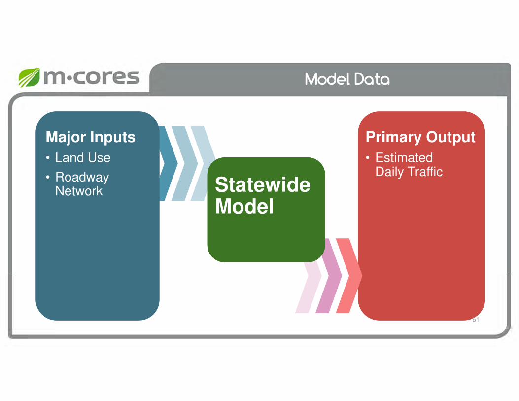
Model Data
Statewide Model
Primary Output
• Estimated Daily Traffic
Major Inputs
• Land Use
• Roadway Network
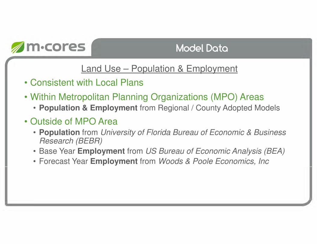
Model Data
• Consistent with Local Plans
• Within Metropolitan Planning Organizations (MPO) Areas• Population & Employment from Regional / County Adopted Models
• Outside of MPO Area • Population from University of Florida Bureau of Economic & Business
Research (BEBR)
• Base Year Employment from US Bureau of Economic Analysis (BEA)
• Forecast Year Employment from Woods & Poole Economics, Inc
Land Use – Population & Employment
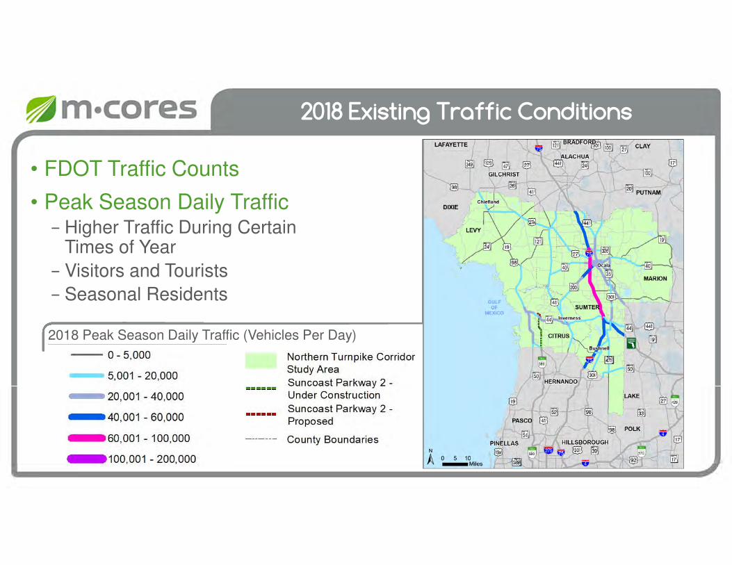
2018 Existing Traffic Conditions
• FDOT Traffic Counts
• Peak Season Daily Traffic − Higher Traffic During Certain
Times of Year
− Visitors and Tourists
− Seasonal Residents
2018 Peak Season Daily Traffic (Vehicles Per Day)
2018 Existing Traffic Conditions
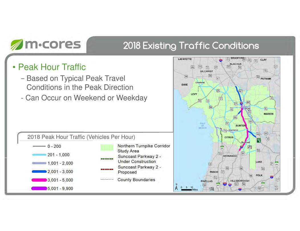
• Peak Hour Traffic
− Based on Typical Peak Travel Conditions in the Peak Direction
- Can Occur on Weekend or Weekday
2018 Peak Hour Traffic (Vehicles Per Hour)

2018 Daily Truck Traffic (Trucks Per Day)
2018 Existing Traffic Conditions
• Truck Traffic− Total Trucks per Day on Each
Segment
− Truck Percentage of Total Traffic
11%
13%
11%
16%
20%
22%8%
20%
17%
X% Truck Percentage
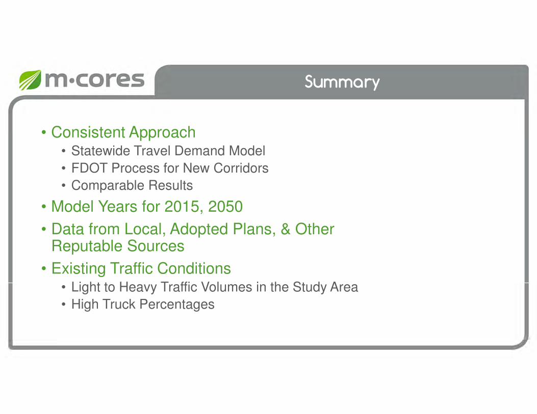
Summary
• Consistent Approach• Statewide Travel Demand Model
• FDOT Process for New Corridors
• Comparable Results
• Model Years for 2015, 2050
• Data from Local, Adopted Plans, & Other Reputable Sources
• Existing Traffic Conditions• Light to Heavy Traffic Volumes in the Study Area
• High Truck Percentages
Overview of Policy Framework Related to Corridor Development Funding
Task Force Meeting #4
February 12, 2020
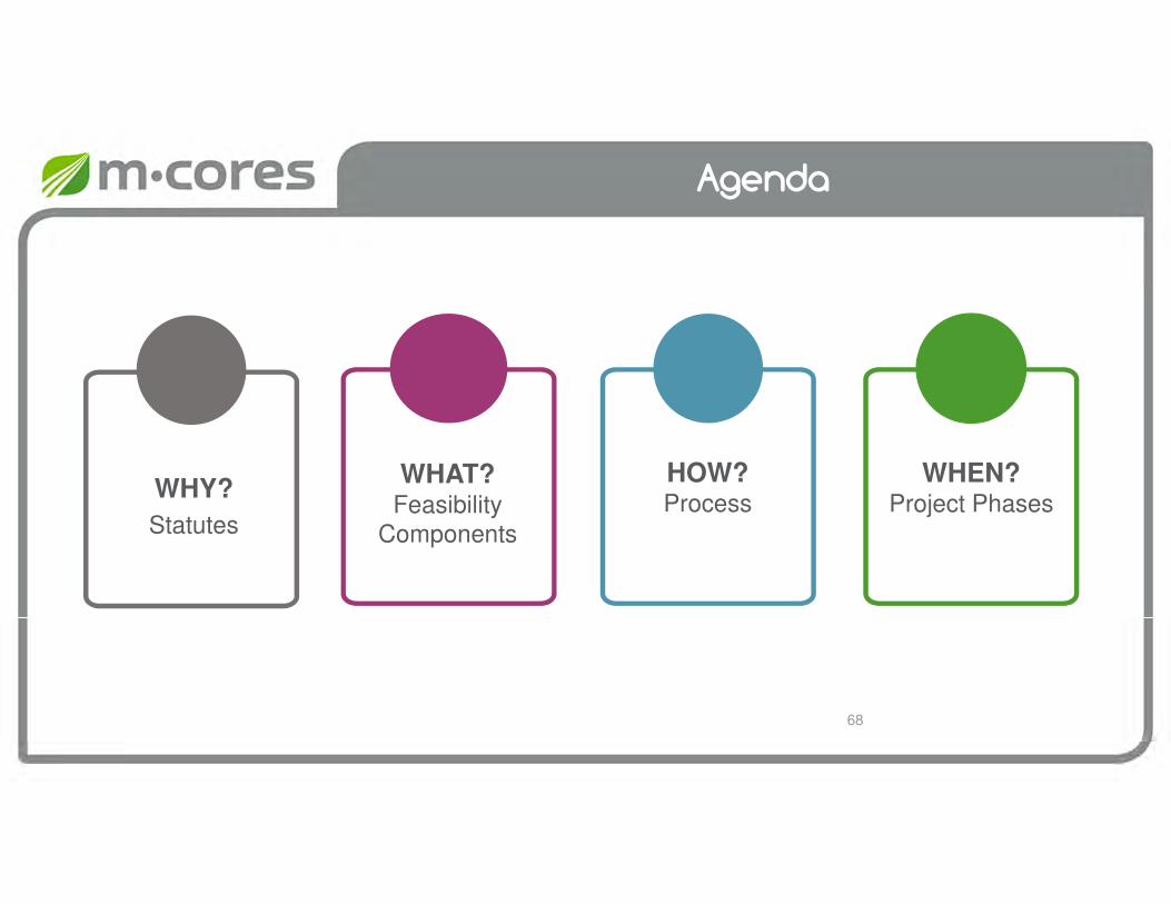
Agenda
WHY?
Statutes
WHAT?Feasibility
Components
WHEN? Project Phases
HOW?Process
68
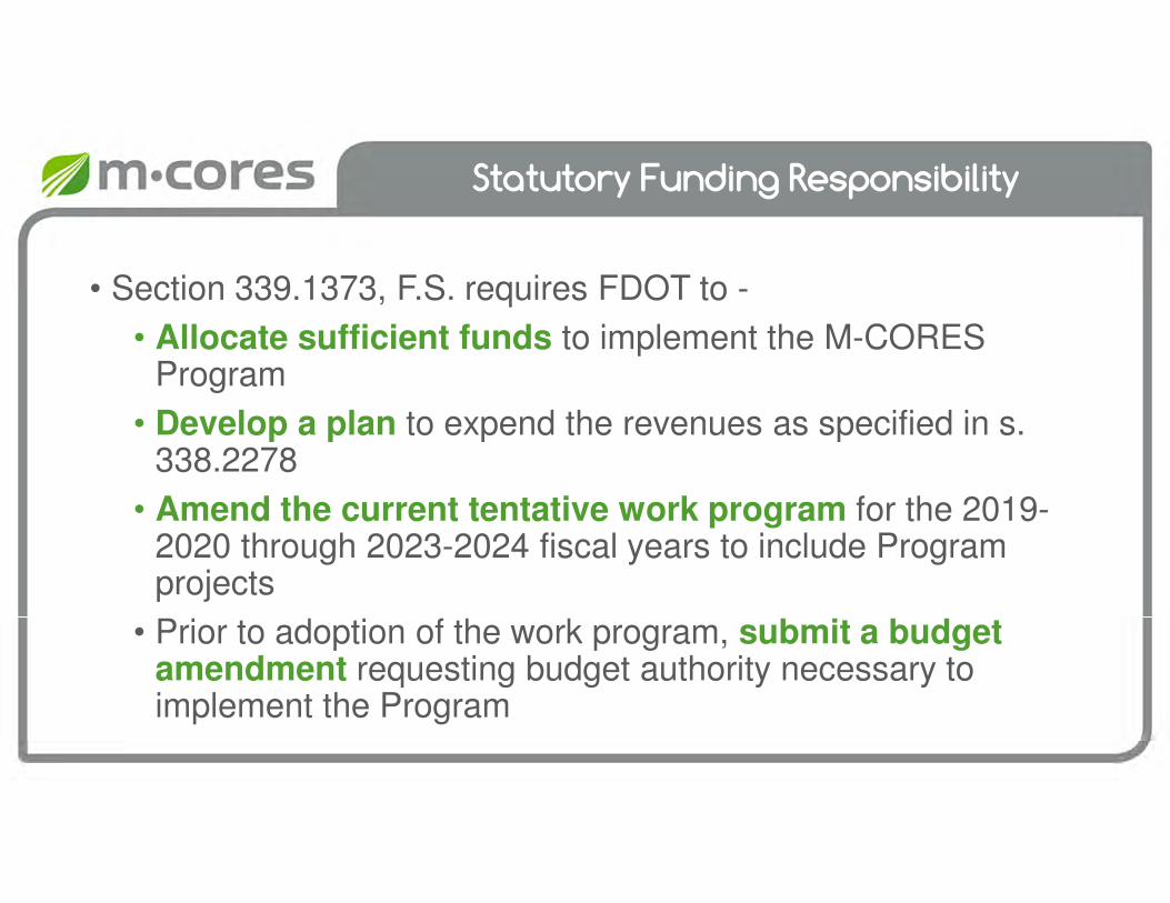
Statutory Funding Responsibility
• Section 339.1373, F.S. requires FDOT to -
• Allocate sufficient funds to implement the M-CORES Program
• Develop a plan to expend the revenues as specified in s. 338.2278
• Amend the current tentative work program for the 2019-2020 through 2023-2024 fiscal years to include Program projects
• Prior to adoption of the work program, submit a budget amendment requesting budget authority necessary to implement the Program
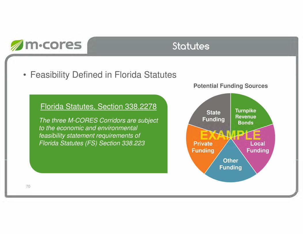
• Feasibility Defined in Florida StatutesPotential Funding Sources
Statutes
70
The three M-CORES Corridors are subject to the economic and environmental feasibility statement requirements of Florida Statutes (FS) Section 338.223
Florida Statutes, Section 338.2278TurnpikeRevenueBonds
LocalFunding
StateFunding
OtherFunding
PrivateFunding

Program Funding Approach
• M-CORES projects may be funded through combination of
• Turnpike revenue bonds or right-of-way and bridge construction bonds or financing by the Florida Department of Transportation Financing Corporation
• By advances from the State Transportation Trust Fund
• With funds obtained through the creation of public-private partnerships
• Right-of-way donations
• Portion of toll revenue may be used to repay advances received from the State Transportation Trust Fund

Program Funding Level
Allocation of Amounts Retained in the State Transportation Trust Fund
Fiscal Year M-CORES SCRAP SCOP TDTFWorkforce
Development
2019-2020 $12.5 million $10 million
$10 million
$10 million
$2.5 million
2020-2021 $57.5 million $10 million
$10 million
$10 million
$2.5 million
2021-2022 $101.7 million (estimated) $10 million
$10 million
$10 million
$2.5 million
2022-2023 & thereafter
$105.9 million (estimated) $10 million
$10 million
$10 million
$0
• These funding allocations are in addition to other statutory funding allocations
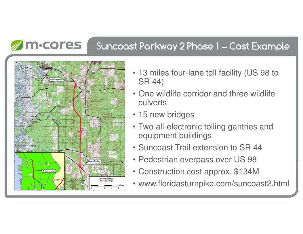
Suncoast Parkway 2 Phase 1 – Cost Example
• 13 miles four-lane toll facility (US 98 to SR 44)
• One wildlife corridor and three wildlife culverts
• 15 new bridges
• Two all-electronic tolling gantries and equipment buildings
• Suncoast Trail extension to SR 44
• Pedestrian overpass over US 98
• Construction cost approx. $134M
• www.floridasturnpike.com/suncoast2.html
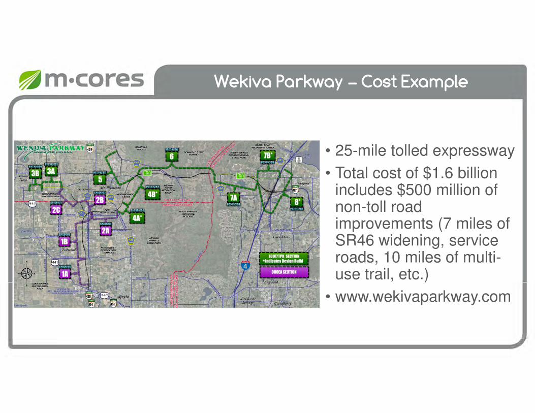
Wekiva Parkway – Cost Example
• 25-mile tolled expressway
• Total cost of $1.6 billion includes $500 million of non-toll road improvements (7 miles of SR46 widening, service roads, 10 miles of multi-use trail, etc.)
• www.wekivaparkway.com

Feasibility Components
1. Environmental Feasibility• Determined as part of the Project Development & Environment
(PD&E) Study • Ensures New Roadway Project Can Be Constructed to Minimize
Environmental Impacts (to Extent Possible)• Focuses on the Natural, Physical, and Social Environments
2. Economic Feasibility• Determined during the Design Phase• Financial Evaluation for New Roadway Projects • Based on the Project’s Net Revenue Forecast• Considers Other Funding Sources
75
Feasibility Includes:

Process
• Determined during the Design Phase
• Requires Net Revenue Forecast
• Utilizes Design-Level Project Cost Estimate
76
Estimate Net Revenue
• Investment-Grade Level Traffic & Revenue Study
This image cannot currently be displayed.
Address Funding Shortfall
• Project Cost
• Other Funding
Determine Turnpike Funding
Contribution
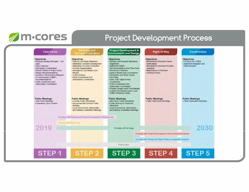
Project Development Process

78
Summary
• Consistent with Statutes
• During the Design Phase− Turnpike Funding Contribution
− Design-Level Cost Estimate
• Consider Other Funding Sources to Address Any Funding Shortfall

Discussion of Alternative Corridor Evaluation Process Consistent with
Guiding Principles
Task Force Meeting #4
February 12, 2020
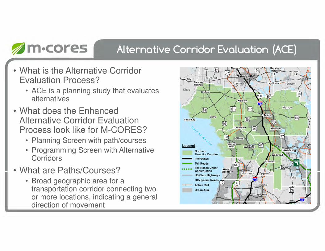
Alternative Corridor Evaluation (ACE)
• What is the Alternative Corridor Evaluation Process?
• ACE is a planning study that evaluates alternatives
• What does the Enhanced Alternative Corridor Evaluation Process look like for M-CORES?
• Planning Screen with path/courses
• Programming Screen with Alternative Corridors
• What are Paths/Courses?• Broad geographic area for a
transportation corridor connecting two or more locations, indicating a general direction of movement
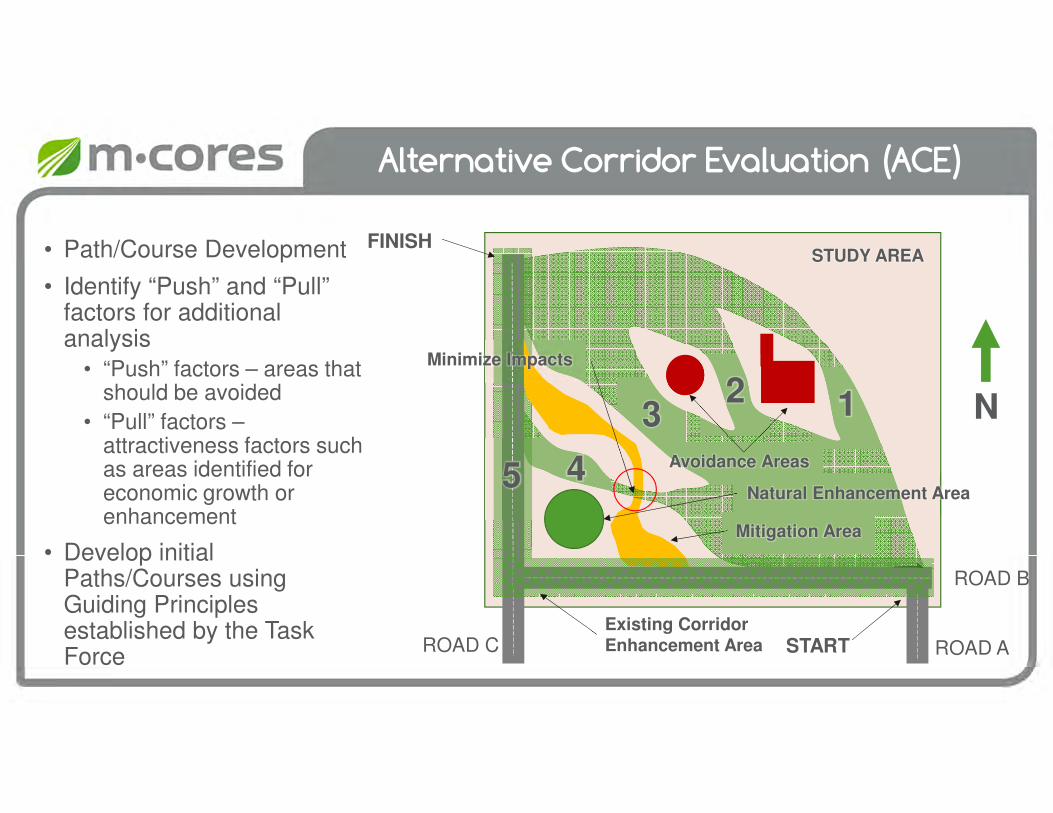
Alternative Corridor Evaluation (ACE)
ROAD A
ROAD B
ROAD C
N
Avoidance Areas
• Path/Course Development
• Identify “Push” and “Pull” factors for additional analysis
• “Push” factors – areas that should be avoided
• “Pull” factors –attractiveness factors such as areas identified for economic growth or enhancement
• Develop initial Paths/Courses using Guiding Principles established by the Task Force
START
FINISH
Mitigation Area
Existing Corridor Enhancement Area
STUDY AREA
Minimize Impacts
123
45Natural Enhancement Area

Alternative Corridor Evaluation (ACE)
ROAD A
ROAD B
ROAD C
N
Avoidance Areas
• Path/Course Refinement based on Guiding Principles
• Paths/Courses may be removed from further consideration based on feedback gained during the ACE process
START
FINISH
Mitigation Area
STUDY AREA
123
5
Minimize Impacts
4Natural Enhancement Area
Existing Corridor Enhancement Area

Enhanced Alternative Corridor Evaluation (ACE)
First step is to define the Avoidance Areas
• Will not impact
• No new corridor through
• Areas resulting from Task Force Member Guiding Principles
ROAD A
ROAD B
ROAD C
STUDY AREA
N
Avoidance Areas
Mitigation Area
Natural Enhancement Area
Existing Corridor Enhancement Area
Break
floridamcores.com

Path/Courses for Northern Turnpike Corridor
Task Force Meeting #4
February 12, 2020
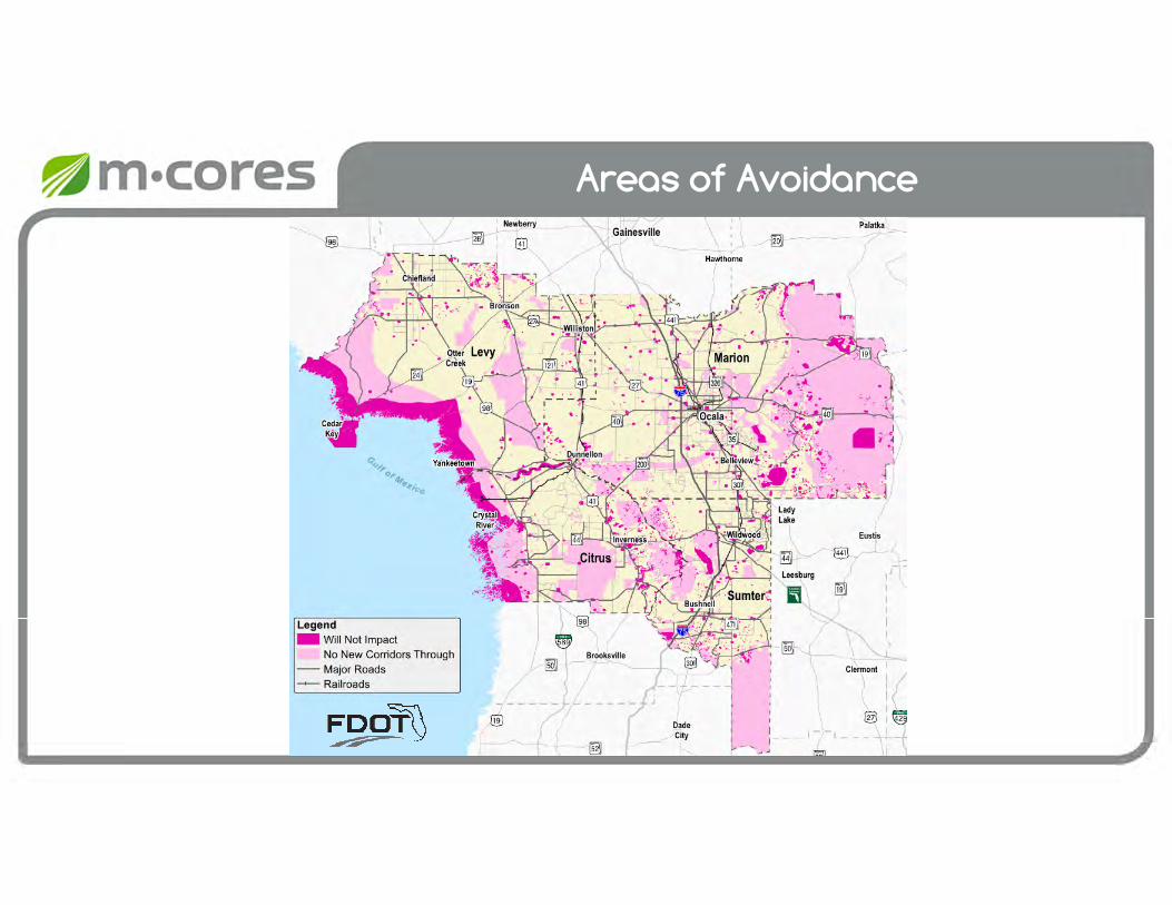
Areas of Avoidance

Areas of Avoidance: Layers
Areas Resulting from Task Force Member Guiding Principles
•
• Wildlife Refuges
• Airports
• Hospitals
• Prisons
• Public Water Supply Plants
• Wastewater Facilities
• Certified Power Plants
• Aquatic Preserves
• Coastal Avoidance Areas
• Florida Forever Owned Properties
• Managed Areas
• Mitigation Banks
• State Forests*
“Will Not Impact” Layers
• Springheads
• High Risk Coastal Zones
• Cultural Sites (Archaeological & Sites with, or the potential for, Human Remains)
• Tribal Lands
• Cemeteries
• National Register Sites (Currently Listed)
• Military Installations
“No New Corridors Through” Layers
* Preserve ability to traverse the Cross Florida Greenway withpotential enhancement opportunities. Needs Discussion.

AMME Guiding Principles:Overview of Avoidance Areas
Task Force Meeting #4
February 12, 2020

Guiding Principles
Guiding Principles
Guiding Principles
Guiding Principles

Guiding Principles

Guiding Principles
AMME Discussion
Task Force Meeting #4
February 12, 2020

Next Steps
Task Force Meeting #4
February 12, 2020
Action Items from Today

Next Steps
• Meeting materials posted online today
• Meeting summary to be distributed in next 2 weeks
• Please complete meeting evaluation form before you leave today
Upcoming Meetings
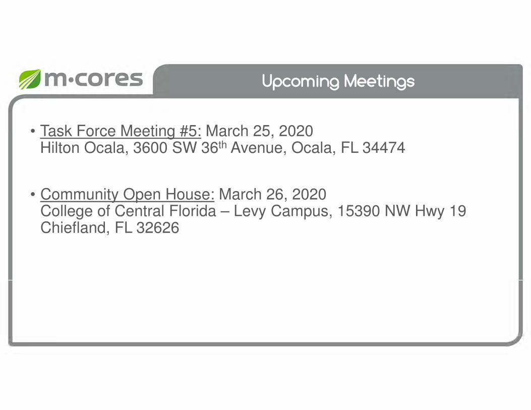
• Task Force Meeting #5: March 25, 2020Hilton Ocala, 3600 SW 36th Avenue, Ocala, FL 34474
• Community Open House: March 26, 2020College of Central Florida – Levy Campus, 15390 NW Hwy 19 Chiefland, FL 32626

floridamcores.com
Public Comments
Task Force Meeting #4
February 12, 2020