Embed Size (px)
Citation preview

rji
1 he Central Artery/
Tunnel Project
Is Not Just Building
A Highway
In Boston.


/t's Laying
The Foundation
For New England's
Future.

i
THE ROADTO THE FUTURE
i
^•^ 1/ the turn of the century, Boston will be a cleaner, greener city.
A better place to live and work. A magnet for tourists and conventions.
A hub of internatio)ial trading for all of Neiv
England.
And we'll get there with the help of the new
Central Artery and Third Harbor Tunnel Project.
Getting us out of a jam. Ru)uiing through the
heart ofdowntown Boston, the Central Artery was
designed in the 1950s to carry 75,000 cars each
day. But some 190,000 cars now clog it daily.
Logan Airport, the tenth busiest in the country, is
only one mile from downtown Boston. But the
traffic makes it feel more like 50.
The congestion is so bad, it threatens to stran-
gle the region. Without radical improvements,
traffic delays here will grow to 14-15 hours a day.
And the effect of those delays will be felt through-
out New England. With so much of the materials
and products of Neiv England businesses being shipped over the
Central Arterif or through Logan Airport, the region will lose an esti-
mated half billion dollars yearly due to late deliveries, accidents, higher
insurance rates andfuel burned by vehicles stuck in traffic. That will be
Today, more than 190,000 vehicles a dayclog the Central Artery.
hard on the business community, and it certainly won't help attract any
of the new businesses—and new jobs—the region needs.
A speedy recovery. The new Central Artery we're building will be an
8-10 lane underground expressway, increasing the flow of traffic
through the city. We've already put the tubes that make up the Third
Harbor Tunnel into place beneath Boston Harbor, between Logan
Airport and South Boston. When it's opened to commercial traffic late
next year, it is projected to carry 18,000 vehicles a day directly from
South Boston to the airport. The final portion of our Project will be to
extend the new artery up and over the Charles River, linking it to 1-93,
Route 1 (Tobin Bridge), and Storrow Drive.
Better trafficflow and easier access to Logan Airport will help make
shipping more efficient, speed deliveries, reduce air
pollution, and lessen the stress levels of com-
muters. Utility companies that have to move their
lines and pipes to accommodate the construction
process are taking this opportunity to upgrade
them, completing Boston's new, state-of-the-art
infrastructure. All told, it will make the whole
region more attractive to businesses, and keep it
competitive throughout the coming century.
In the meantime, the Project is delivering
immediate economic benefits to the region. Right
now more than 5,000 people are employed in
the planning, design, construction, and procure-
ment of materials for the Central Artery/Tunnel
Project. And another 4,000 people have jobs in
restaurants, printing companies, delivery services,
and other businesses thanks to money being poured into the local econ-
omy by the Project.
A better environment all around. Putting an end to the traffic jams
that make you see red will also enable you to see more green. Wlien the

underground expressway is completed, the old, elevated roadway will be
torn down, opening up 27 acres in the heart ofdowntown Boston that
can be developed into parks, playgrounds, new businesses, botanical
gardens, and an arboretum. In total, 150 acres of parkland will be
created throughout the region.
Since fewer cars will be sitting and idling on the new expressway,
we'll all breathe easier because Boston's air will be appreciably cleaner.
People who live in the city's neighborhoods won't find their streets
being used as on and off-ramps to the Artery, or as alternate routes in
rush hour Without that traffic, their neighbor-
hoods will be quieter, safer, and cleaner.
And when Boston is no longer cut in half
by the Artery, this walk-able city will be more
pedestrian-friendly than ever; and an even
more attractive destination for tourists and
conventions.
A lot of the dirt being excavated to put the
new roadway underground will go to good use.
Some of it will be used to cap an old landfill on
Spectacle Island (one of the Boston Harbor
islands) and transform it from a dump into a
beautiful public park; more of it will go to cap-
ping landfills in communities around the state,
saving millions of dollars for local taxpayers.
As with any construction project in a
populated area, there are going to be disrup-
tions and inconveniences. Digging up streets
and excavating tunnels is going to be noisy,
kick up dust and dirt, and cause occasional traffic problems. But the
economic and environmental advantages of the Project promise a
much improved quality of life for people in New England for
generations to come.
3**
At the peak of construction, almost 15,000 people will be
en-iployed as a result of the Central Artery/Tunnel Project.
Work on the Third
Harbor Turmel
(lower left) is on
schedule for a late
1995 opening.
Meanwhile, using
sophisticated com-
puter technology
(lower middle),
engineers, urban
designers, environ-
mentalists, traffic
planners, and oth-
ers are able to plan
the completion of
the Project, when
27 acres of open
space will be made
available down-
town. Having
received all the
necessary approvals
on the plan for the
Artery's crossing
of the Charles River
(lower right), final
design will begin
this fall.

THE SOUTHSTATION STORY
jjf/ze work being done here is so complex, it's a story unto itself.
Almost 80,000 people move through the South Station area every
day by bus, on foot, aboard the MBTA's Red Line, AMTRAK,
or on commuter rail. So imagine the challenge of trying to keep
those people moving while simultaneously relocating utility lines
under the streets, rebuilding and expanding the Red Line tunnel
and station, digging a tunnel for the new underground Central
Artery, and creating yet another tunnel for a new MBTA transitway
electric trolley link (for service from South Station to the Fan Pier).
Finally, the Central Artery/Tunnel Project is also evaluating the
necessary modifications to allow for the future construction of
a North/South rail link. And while all this is taking place, every
possible precaution will be taken to preserve the historically significant
architecture of South Station itself.
The plot thickens. Why is so much work being undertaken at once?
Because years of work and millions of dollars can he saved by doing
4
all the construction simultaneously. Mean- ifj^A
while, extraordinary steps are required to
keep the area fully operational when X ^
/
construction begins in early 1995.
To minimize surface traffic disruptions, the digging
is planned so that only one lane of any street is closed at a ^5^o'(^''>
time. For Red Line passengers, the station is being re-constructed *;?;;;^^
one corner at a time, in order to keep the station accessible. Clean,
well-lit walkways with easy-to-read signs will be built to carry pedes-
trians quickly and safely around construction work. The Red Line and
commuter rail lines will continue their regular schedules while a major
section of the new underground Central Artery is dug underneath
Atlantic Avenue, just below the Red Line track.
That's a lot of activity. But wait until you see the activity when
all of this work is completed and South Station is a world class trans-
portation centerfor moving people to and through Boston.
Each phase of con-
struction at South
Station is being
picinned to main-
tain traffic and
pedestrian flow
through this very
busy part of town.
For example. In the
second drawing
of this computer
sequence, the
old bus station has
been moved to give
traffic planners
flexibility while
shifting Atlantic
Avenue and the
Surface Artery
traffic away
from construction.
At least two
lanes of traffic will
be maintained in
all directions at
all times. On the
far right is a profile
V|> of one part of the
\f construction site.

Mapping The Future of New England.

GOING TO WORKDOWNTOWN
Jl^irst, the bad news. Despite our best efforts, some delays and incon-
veniences will become an unfortunate part of our everyday life. For
example, although traffic flow will he maintained,
streets may have to be realigned or individual lanes
shifted around work sites. Parking spaces may have
to be relocated to make wayfor drilling or digging.
Now, the good news.
The biggest neivs is no news. Every possible
step is being taken to keep the city open for busi-
nesses, residents, and tourists. Work is being
scheduled to minimize the irritation of noise and
dust for people who live in the area; to avoid block-
ing building entrances and loading docks during
commercial hours; and to prevent interference with
the pushcarts at Haymarket or with events at
Boston Garden. Pedestrian walkways will be
built to ensure that, even at the height of the
construction work, you can still stroll through
Chinatown, browse the art galleries in the Leather
District, and dine at your favorite restaurants
in the North End and Waterfront areas.
Plugged into the future. Utility relocation work is continuing
throughout downtown Boston, where 29 miles ofwires, pipes, and cables
Some of the first walls of the underground expresswaywill begin to be built between the North End and the
Faneuil Hall/Marketplace area later this summer.
snake beneath the city's streets. In a major undertaking that involves 31
utility companies, these lines, some more than 100 years old, will be
moved out of the path of the digging and into new, specially constructed
utility corridors running alongside the new Artery. They'll be easier to get
at, maintain, and expand. More important, many ofthe utility companies
will be using this opportunity to upgrade their lines, creating a state-of-
the-art infrastructure which will benefit the entire regional economy.
In addition to the traditional method ofdigging a trench, laying the
cable or pipe, and covering the street up again (known as cut and
cover), the digging has taken on a decidedly high-tech feel. Some of the
work is done using a technique called jack pipe tunneling, in which pits
are dug on opposite sides of the street, and lengths of pipe are then
pushed underneath the street (jacked) from one pit to the next—with-
out disturbing the surface above.
When pipes smaller than three feet in
diameter are being installed, another innovative
technique called micro-tunneling is sometimes
used. Here, a remote-controlled robotic drill bores
a hole from pit to pit while the operator watches
from the surface on closed-circuit video monitors.
These techniques are just part of the Central
Artery/Tunnel's overall commitment to minimize
disruption during construction.
Tlie walls go in, the work goes on. A major
milestone for the Project is the construction of the
first wallsfor the underground expressway , which
will start this summer. Actually built from the
surface down using a technique called slurry wall
construction, these walls will hold back the earth
from the new roadbed. The slurry technique involves
excavating a narrow, deep trench held open by a
jello-like mixture ofclay and water called bentonite
slurry. This allows digging to continue to the desired depth without a
wall collapse. Steel cages, which add support to the walls, are lowered
' -TT^^
^ OM i-t'' •
i)ito till' iiJurn/-fiUed trench. Concrete is then poured into the trench,
displacing the slurry, and the xvalls are done. Steel beams and decking
will be laid between the walls so that traffic can continue on the elevated
roadway while work goes on underground.
Also, later this year, temporary ramps connecting 1-93 with
Route 1 and the Tobin Bridge will be completed. Instead of Route 1 con-
necting to Route 93 on the City Square side of the road, it will sweep
under and connect to the highway over the MBTA rail yard. This will
eliminate the dangerous three-lane weave across Route 93 now required
of drillers traveling between Route I
and Storrozv Drive. The old ramps that
have cast a shadow over Charlestown's
City Square will finally be eliminated.
This will also do much to relieve
the congestion on that northern
stretch of the Central Artery until the
new Charles River Crossing can be
completed. Aesthetically pleasing,
environmentally responsible, and cost
conscious in design, the plan for the
new Charles River Crossing has been
approved by state andfederal agencies
and final design will begin this fall.
Meanwhile, work continues in
the Third Harbor Tunnel as crews install the tiling, lighting, computer
sensors, and ventilation systems. And since the new tunnel will help
ease legendary traffic jams in the Sumner and Callahan Tunnels,
Governor Weld has proposed the new harbor tunnel be named after leg-
endary Nezv England sports figure Ted Williams. When the tunnel
opens to commercial traffic next year, it will reduce traffic in the exist-
ing tunnels by 6,000 vehicles a day.
At the southern end of the new tunnel, the South Boston Haul
Road is already open and keeping an estimated 1,500 trucks off the
streets of South Boston daily.
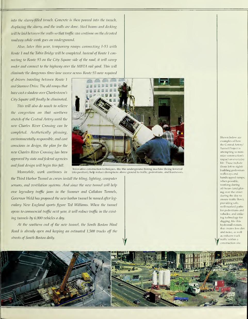
Innovative construction techniques, like this underground boring machine (Lx>ing lowered
into position), help reduce disruptions above ground to traffic, pedestrians, and businesses.
Shown below are
examples of howthe Central Artery/
Tunnel Project is
attempting to mini-
mize construction's
impact on everyday
life. TTiese include
(from left to right):
building pedestrian
walkways and
handicapped ramps,
when possible,
working during
off-hours (and plat-
ing over the street
during the day to
ensure traffic flow);
providing safe,
well-marked paths
for pedestrians and
vehicles; and utiliz-
ing technology for
digging, like this
hydromill station,
that creates less dirt
and noise, as well
as reduces truck
traffic within a
construction site.

SORTINGIT ALL OUT;
"^^^^ dig history. Before the Central ArteryfTunnel Project digs
for Boston's future, the Project's historic resource protection program
is digging into Boston's past, helping
us learn all ivc can about the history
of our region.
One particularly rich find was
made under a parking lot under the
elevated Artery in the North End,
yielding many interesting artifacts
of Colonial life, from tiles to ceramic
wig curlers.
Out on Spectacle Island, research-
ers also unearthed a Native American shell midden ~ a 1,400-year old
dump where remains of meals, broken tools, potterxj, spear and arrow
points, and other trash were discarded. This discovery will tell us much
about the way Native Americans lived in the area.
Facts and factoids. Tlnrd Harbor Tunnel: Traffic capacity: 4 lanes
(2 each way, doubling existing cross harbor capacity) Number ofgiant
325-foot tubes needed to span harbor: 12 _ Time it will take to build the
tunnel: 4 years; time it will take to travel through the tunnel: less than
10 minutes Number ofaverage bathrooms that could befinished with
the ceramic tiles used to cover the tunnel's walls: 4,600 Ifyou zvere
to stack the tunnel's 12 tubes vertically, they would stand more than
Before construction could begin, archaeologists were first given the opportunity
to unearth new information about Colonial and Native American history-
two-and-a-half times as high as the Empire State Building C] Central
Artery: Number of lanes today: 6; number of lanes on new under-
ground artery: 8-10 Current number ofaccess ramps downtown: 27;
Access ramps to/from new underground expressway: 14 Tons ofsteel
in existing Central Artery: 100,000 (enough to buildfive Tobin Bridges)
Yards of concrete needed to build the Central ArteryfTunnel Project:
3.8 million cubic yards (enough to build a sidezvalkfrom Boston to San
Trancisco 3 times)C\At its deepest point, the tunnel will be more than
8 stories undergound You could wrap a one-inch steel bar around the
Earth's equator with all tlie reinforcing steel tluit this Project will useH
Traffic: Designed capacity of existing Central Artery: 75,000 vehicles
per day Traffic volume of Central Artery today: 190,000 vehicles per
day Capacity ofnew underground Central Artery: 250,000 vehicles per
day Current average speed ofevening
rush hour traffic: 8 mph (northbound)
Projected average speed of evening
rush hour traffic on new underground
Central Artery: 30 mph Current
traffic volume through Sumner/
Callahan Tunnels: 100,000 vehicles per
day; Sumner/Callahan traffic in 2010
with addition of Third Harbor Tunnel:
70,000 vehicles per day Related
Mass Transit Improvements: Number of neiv subway and streetcars
being added to MBTA's fleet: 200 [J Number of new buses to be added:
200 Number ofcommuter rail park 'n ride spots being added through-
out metro area: 15,000-20,000 Environmental: Acres ofopen space
that will be created on top ofnew underground artery: 27 Size ofpub-
lic park that will be created at Spectacle Island: roughly 105 acres
Reduction in overall carbon monoxide levels as a result of improved
traffic flow provided by Project: 12% ^Archeology: Date of artifacts
unearthed at Paddy's Alley: 1680-1740 Likely dates of artifactsfrom
Spectacle Island: 4000 BC-1500 AD [J Economics: Number of con-
struction workers at peak construction: 5,000 Total number ofpeople
,1

employed as a result of the Project at the peak of construction: approxi-
matehf 14,700 II Animal waste in fuel consumption, late deliveries, and
lost personal time in year 2010 if no transportation improvements were
made: $53>0 million Projectfunding provided by the Federal Highway
Administration: 85%; Projectfunding provided by the Commonwealth
of Massachusetts: 15% Geotechnical Science: Amount of excavated
material placed to close abandoned dump and create new park on
Spectacle Islaiid: 2.7 million cubic yards [ \ Total quantity of material
excavated or dredged: 11.9 million cubic yards (enough to fill Foxboro
Stadium to the rim
12 times)nNumber
of soil and ground
samples taken: more
than 1,600B Smart
Highivays: Number
ofclosed circuit TV
cameras that will
monitor Project work
zones: approximately
400UNumber of
electronic variable message highway signs located on regiotml highways
that will be programmed by the Project operations center: 230
Number of infrared truck overheight detectors: 30 \3 Minutes it will
take the Smart Highways system to detect, untangle, and clear away
traffic mishaps: approximately 15.
Getting through; on the road or on the phone. We're doing massive
work on some of Boston's main roadways. But we're also doing every-
thing in our power to minimize the impact of that work on the traffic
that has to go through the city every day. And you can help in several
ways, too. Keep an eye (or an ear) on the news for traffic reports, and
watch for our message signs on the roadfor traffic condition updates. If
you own or run a business, think about vanpools, carpools, MBTA
employee passes, flex-time, and variable work hours. And keep this list
handyfor easy reference:
Spectacle Island will receive over 2 million cubic yards of
dirt and fill from the Project, turning this former dump into a public park.
Perhaps the most visible result of the Central Artery/
Tunnel Project will be the removal of the elevated road
that has cut off the downtown from the waterfront (far
left). Below ground, telephone, gas, sewer, power, steam,
electric, and cable lines that criss-cross under the city
are being upgraded and placed in specially constructed
utility corridors, making them easier to find and repair
in the future.
COMMUTERINFORMATION
It pays to plan ahead. For the
latest word on traffic detours and
Project news 24 hours a day, call
CAT-INFO 617-228-4636.
Help yourself. Get emergency
assistance and construction problem
resolution 24 hours a day by calling
CAT-HELP 617-228-4357.
Learn more about the T...The
alternate route. Call 617-722-3200 for
public transporation information.
For big savings on toll fares on car
pools, call the Mass Pike Car Pool
Pass Program at 617-248-2833.
Save time and money getting to
Logan Airport. ..use mass transit or the
water shuttle. Dial 1-800-23LOGAN
(1-800-235-6426).
Get out from behind the wheel and
get into a car pool or van pool. Call
CARAVAN For Commuters, Inc. at
CAR-POOL (617) 227-7665.
Don't get stuck in a jam.
For up-to-the-minute traffic and
transit conditions, call SmarTraveler
at 617-374-1234.
OTHER INFORMATION
To contact the Project's Liaison to
your community, call 617-342-4556.
To do business with the Project,
call the Procurement Department at
617-342-4520.
To schedule a briefing or
obtain Project information for
your business or employees, call
the Business Outreach Department
at 617-951-6367.
Cover Photo by Steve Dunwell/lmage Bank
Photos by Louis Martin.

B
2 Sill" " '«
,lnl,,lH|, ,1
«8 Jli UMu. ,lululnlMl, .1
.ImIm|,,Im|,,
I'ill ill ik.
1'ill ill ill ii,
ill ill ill
I'l'ill ill 1,
ill' ill ill >i>
I «i II 11
I ii Ii' ii
9 II II fl
• > « II II II II
II 111 III 11 II II
III I lit ii II II
11 III 9 iw II II
Ji I Ii ii II II
II II l|! II II II
II I lii ii
I If II II
1 lii ii II
i|i 11 II
) lii ii II II
i III 11 II It
I lii ii II II
I III 11 II II
ii lii Ii II II
|i If: |l II II
II It
nII II
II
II
II
1 1 11 1
1
1 1 Ii Ii 1
1
1 1 II !l
1 1 II II 1
1
1 1 II M 11
Ii 11 >
1 1 11 1! I
1 1 ii ii 1
1
11 !! !! >
11 11 ii *
1 1 ii ii I
1 1 ii ii I ^
III!!!'11 ii ii •
liiiil •
11 Ii ii '
11 !l II
nil ii I
11 ii ii I
11 ii •
nil II
'
11 ii ii
Li i»
This Report to the Public is a product of a public/private partnership between the Massachusetts Department of Transportahon
and the \rtery Business Committee. State and federal funds were used to produce this progress report at a cost of 23c per copy.
It is being distributed free by The Boston Globe, The Boston Herald, and The Patriot Ledger as a public service.