Embed Size (px)
Citation preview
THE MINISTRY OF NATIONAL
INFRASTR UCTURES
GEOLOGICAL SURVEY OF ISRAEL
NOTES ON THE GEOLOGY OF
) Based on the 1:50,000 geological maps of Har .. ..,.. '~""~~.ג~~:!,!
D. Mor, H. Michelson, Y.
/'
/ : ' /~ /' .
/ .. ". r /'·
.~- -::"
'- "\
..• "' '-.,1.
.?>~
י-~"
.~ ....... -.--. /f .;-"/-./.
_,< .. 4j·d ~:ג-·.:ז If • , ... ,. ,', .. '-> ~ -j "
~~,.~ .~ ~ ..
~
r I
r r
r
~
r-
!-
State of IsraeI
The Ministry ofNationaI Infrastructures
GeologicaI Survey of IsraeI
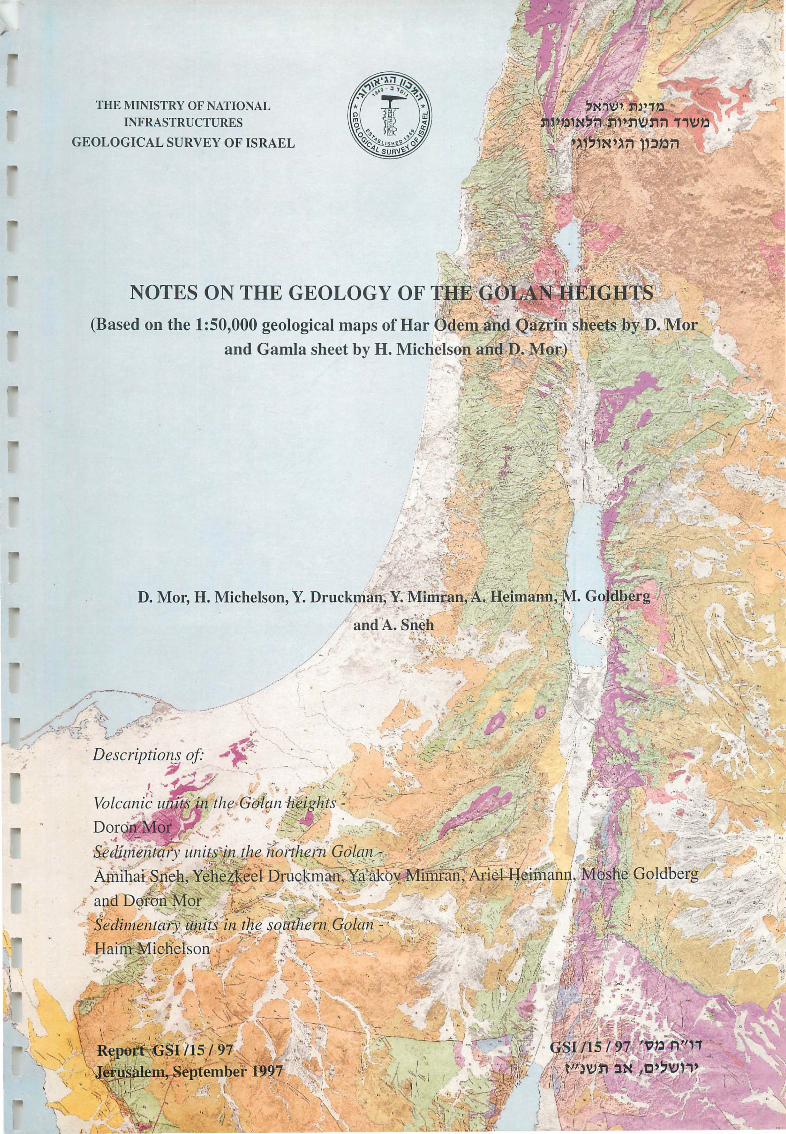
NOTES ON THE GEOLOGY OF THE GOLAN HEIGHTS
(Based on the 1:50,000 geological maps ofHar Odem and Qazrin sheets by D. Mor
and Gamla sheet by H. Michelson and D. Mor)
by
D. Mor1•2, H. MicheIson3, Y. Druckman1, Y. Mimran1, A. Heimann1, M. Goldberg1
and A. Sneh1
1 Geological Survey ofIsrael, 30 Malkhei Israel St. Jerusalem 95501 2 Qibbuz Merhavya 3 Water Planning for Israel, Tel Aviv
Descriptions o[
Volcanic units in the Golan heights by
DoronMor
Sedimentary units in the northem Golan by
Amihai Sneh, Yehezkeel Druckman, Ya' akov Mimran, Ariel Heimann, Moshe Goldberg and Doron Mor
Sedimentary units in the southern Golan by
Haim Michelson
Report GSI/15/97
Jerusalem, September 1997
2 r r CONTENT
4 .................................................................................................................. Preface 5 ........................................................................................................... ntroduction ז
6 ........................................................................................................... Stratigraphy 6 ....................................................................................................... 1. Arad Group 6 ......................................................................................... 1.1. Hennon F onnation 7 ............................................................................................ 1.2. Kidod Fonnation 7 ................................................................. 1.3. Be'er Sheva and Haluza fonnations 8 .................................................. 2. Kumub Group and lower parts of Judea Group 8 ............................................................................................... 2.1. Bhannes Basalt 8 ............................................................................................ 2.2. Hatira Fonnation 8 .................................................................................... 2.3. Ein el Asad Fonnation 9 ............................................................................................ 2.4. Kati'h Fonnation 9 ......................................................................................... 2.5. Mas'ada Fonnation 9 ................................................................. 3. Judea Group, middle and upper parts 9 ............................................................................................ 3.1. Yagur Fonnation 9 .................................................................................... 3.2. Deir Hanna Fonnation
10 ......................................................................................... 3.3. Sakhnin Fonnation 10 .............................................................................................. 3.4. Bina Fonnation 10 ....................................................................................... 4. Mount Scopus Group 10 ......................................................................................... 4.1. Menuha Fonnation 10 ........................................................................................ 4.2. Mishash Fonnation 10 .......................................................................................... 4.3. Ghareb Fonnation 11 ........................................................................................... 4.4. Taqiye Fonnation 11 ................................................................................................... 5. Avedat Group 11 ......................................................................................... 5. 1. Adulam F onnation 11 ........................................................................................ 5.2. Maresha Fonnation 12 .................................................................................. 5.3. Bar Kokhba Fonnation 12 .................................................................................................... 6. Saqiye Group 12 ................................................................................................ 6.1. Fiq Fonnation 12 ............................................................................................ 6.2. Susita Fonnation 13 ................................................................................................ 6.3. En Gev Sands 13 ......................................................................................... 6.4. Hordos Fonnation 14 ............................................................................................... 7. Dead Sea Group 14 ............................................................................ 7.1. Bira and Gesher fonnations 15 ........................................................................................... 7.2. Gadot Fonnation 15 ........................................................................................... 7.3. Hazor Fonnation 15 ............................................................................................... 7.3.1. Si'on Gravel 15 ......................................................... ; ................................... 7.3.2. Buteiha Gravel 16 .................................................................................. 7.4. Kefar Yuval Travertine 16 ............................................................................................... 7.5. Dan Travertine 17 ................................................................................................... 8. Bashan Group 17 .................................................................................................. 8.1. Cover Basalt 18 .................................................................................................... 8.2. Eitar Basalt 18 ............................................................................................. 8.3. Ortal Fonnation 19 ............................................................................................... 8.3.1. Dalwe Basalt
r '-
r
r
r-, l.
rי' L
r i
r
~ 1,
r L
r-
rיי
jiIII
•
!יי, L

~
l
Jl
r
3
8.3.2. Sheivan Scoria ............................................................................................ 19 8.3.3. Hasbani Basalt ............................................................................................ 20 8.3.4. Yarmouk Basalt .......................................................................................... 20 8.4. Golan Basalt .................................................................................................. 21 8.4.1. Muweisse Basalt ......................................................................................... 21 8.4.2. Keramim Basalt .......................................................................................... 22 8.4.3. Odem Scoria ............................................................................................... 22 8.4.4. 'En Ziwan Basalt ........................................................................................ 23 8.4.5. Avital Tuff .................................................................................................. 23 8.4.6. Raqqad Basalt ............................................................................................. 24 8.4.7. Berekhat Rarn Tuff ..................................................................................... 24 8.4.8. Sa'ar Basalt ................................................................................................ 25 9. Undivided basalt ............................................................................................... 25 10. Alluvium ......................................................................................................... 25 Geological structure ............................................................................................. 25 1. The Hennon anticline ........................................................................................ 26 2. The geological structure beneath the volcanic plateau ....................................... 26 3. Faulting ............................................................................................................ 27 4. The volcanic alignments .................................................................................... 28 Geological history ................................................................................................. 29 Economic Geology ............................................................................................... 31 Acknowledgments ................................................................................................ 32 References ............................................................................................................ 32
4
PREFACE r notes are provided for three 1 :50,000 geological maps: Har Odem, Qazrin yזExplanato
and Gam1a, covering the area of the Golan heights. The stratigraphic column of the rocks
g area extends ftom the Jurassic to the Quatemary. It comprises מithe mapp מig out מicropp
the Hermon מiunits attributed to 8 groups. The Arad and Kumub groups, exposed
the northem Golan, and the Avedat מistructure; the Judea and Mount Scopus, found only
, the south. Al1 these units מiand lower parts of the Saqiye which build the canyon cliffs
thickness, are marine. The upper parts of the מiage, 3000 m מiJurassic to oligocene
ental and are. about מiMiocene, Saqiye Group, with the exception of few thin beds, are cont
300 m thick. The overlying Plio-Pleistocene Bashan Group build the volcanic plateau ofthe
Golan height, is of varying thickness, up to few hundreds of meters, and comprises basalts
as welI as pyroclasts. Contemporaneously, sediments of the Dead Sea Group accumulated
within the subsided Rift to the west of the Plateau
r
r
rl
r r 1-
Still to be completed before publication ofthe final edition ofthe maps are: a) the detai1ed
) the Hermon area; b מistratigraphy ofthe thick Jurassic section ofthe Hermon Formation
the Hermon structure and the Lower Cretaceous מiresearch on the tectonic elements
the map was provided by A. Shimron (1986; and מicluded מivolcanism; data on the latter
written comm., 1987) and is only preliminary; c) the stratigraphic division of the "undivided
the southwestem part מig of the tectonic features מithe westem Golan; d) mapp מi" basalts
. of the Qazrin sheet on the westem side of the Jordan River; and e) dating additional sites
r
r I
r r r-!
r L
L
5 r INTRODUCnON ~
l
r-i L
The following explanatory notes relates to the geology mapped and displayed in three
1:50,000 sheets: Har Odem (Mor, 1987a), Qazrin (Mor, 1987b) and Gamla (Michelson and
Mor, 1985). The boundaries of these sheets, being different :&om those of the regular
topographic sheets of the Survey of IsraeL were chosen to cover the whole of the Golan
. heights which is one phisiographic unit, in 3 sheets
This physiographic unit is divided into two and is highly in keeping with the geological
: cture stזu
1. the folded Mount Hermon north ofNahal Sa'ar, built predominately ofthick Jurassic
limestones and some shales and
2. the young Golan volcanic plateau south ofNahal Sa'ar, that slopes :&om NNE to SSW
and on which tens of volcanic cones stand out. Likewise, the location of the cliffs, and
hence of the canyons, in the westem Golan heights, towards the Hula Valley and the
. Kinneret, is dictated by the main faults ofthe Rift Valley
The entire area drains directly or indirectly to the Jordan basin. The water divide, which
runs :&om north to south in the eastem part of the Golan heights, divides the area into twO
secondary basins: the larger westem one drains directly into the Jordan River and Lake
Kinneret, the smaller eastem one, to the Raqqad and Yarmouk rivers and through them, to
, the Jordan. Water t10ws in the Golan streams during most ofthe winter and spring months
and in some, also during the summer. On the Golan plateau itself the streams are quite
shallow, but they deepen, cutting canyons as they approach the Hula Valley, Lake Kinneret
and the Yarmouk and Raqqad rivers. The climate is Mediterranean, with average annual
precipitation ranging :&om around 1100 mm at the swnmit of Mount Hermon down to
. around 500 mm in the southem Golan heights
The geological mapping ofthe volcanic units in the Golan heights on a 1 :50,000 scale was
carried out in several stages in the course of the years 1967-1986, as part of research
projects on the volcanism ofthe Golan heights (Mor, 1973, 1985, 1986). The sedimentary
units ofthe northem Golan are presented following Sneh et al. (1985), who based their map
mainly on previous mapping ofthe area (see below). Some.ofthe dip measurements were
provided by P. May (written comm., 1986). The sedimentary units of the southem Golan
.) 1979 , 1972 ( were studied and mapped by Michelson
r r r
rיי. J
r-1,
rl
r l
r ~
, Iי"
i 1l11li !
r ~ i i.
fIi! L
r
r r r
r-I
l.
6
The Mount Hermon area was previously mapped by Dubertret (1954, 1960) within the
framework of mapping the Levant. The Golan was previously mapped by Ponikarov et al.,
(1963-64) as part ofthe geological map of Syria. Golani (1962) carried out initial mapping
in the En Gev area. After 1967 the northem part of the Golan and the Hermon were
mapped by Saltzman (1968) and by Michelson (1975). Part of the central Golan was
mapped by Netser (1982). Heimann (1985) mapped the northem Hula Valley.
STRATIGRAPHY
The stratigraphic column of the rocks cropping out in the mapping area extends from the
Jurassic to the Quatemary (Fig. 1). Fol10wing is a brief decription ofthe mapping units. The
division of the sedimentary rocks was made on the basis of lithostratigraphic criteria; that of
the volcanic formations and members was made using morphological as welI as
chronostratigraphic criteria.
Fossil identification was made at the Geological Survey and at the Israel Petroleum
Institute; the radiogenic age determinations were carried out in the Survey's geochronology
laboratory.
1. ARAD GROUP (Jurassic)
The lithostratigraphic fonnations of the Arad Group in the mapping area are: Hermon,
(Dubertret, 1975) Kidod, Beer Sheva and Haluza (Goldberg, 1969, 1980; Goldberg et al.,
1981), which are units J4, J5, J6 and J7 ofDubertret (1960, 1963), respectively. These rock
units extend chronostratigraphically from the Middle Jurassic Bathonian stage into the
Upper Jurassic, Upper Oxfordian stage.
Derin (1969) found a high degree of similarity between the Hermon and the Negev
sequences.
1.1 Hermon Fonnation (Jmh)
Except for a few shales and calcareous shale beds in its upper parts, the Hermon
Formation is built mainly oflimestone (biomicrite in most cases) and some dolomite. A few
calcarenite beds, occasionally oolitic, are scattered throughout the sequence. The formation
is 623 m thick, but its base is not exposed in the mapping area. It covers almost all of
Mount Hermon and was divided into three members (from bottom to top): Mizpe-Shlagim,
7
massively bedded and cliff forming - 170 m thick; Bol'an, finely bedded - 95 m thick; and
cluding מiMa'ale Golani, whose rocks are highly fi"actured - 358 m thick. Karstic features
the latter. The upper part of the formation was correlated with the מidolines are common
. upper part ofthe Zohar Formation in the Negev
) 1.2 Kidod Fonnation (Juk
, The Kidod Formation is 155 m thick; it consists of shales, for the most part calcareous
the upper part of מipyritic and lignitic. These are generally light gray-brown to yel10w, but
the middle part the shales מI. the formation they are dark gray (''black'') and gray-brown
tra biosparite, occasionally מialtemate with thinly bedded limestones, mostly calcarenite and
oncolitic; in the lower part of the formation the shales are fossiliferous; ammonites and
belemnites (mostly pyritic and/or hematitic) are very abundant. There are also some plant
the Majdal מia few localities מiremains and vertebrate bones. Basaltic intrusions are found
. Shams-Qal' at Nimrud area
r l
rוI
r I
) 1.3 Be'er Sheva and Haluza fonnations (Jub and Juh
The Be'er sheva Formation is 100 m thick and consists mainly of light gray and whitish
sponge spicules, and intrabiosparite). The limestones מiplaces rich מi, limestones (biomicrite
are well bedded; in the lower part of the formation the beds are thin and alternate with dark
gray shales; in the upper part they are massive and cliff-forming. The upper part ofthe Be'er
Sheva Formation is characterized by the presence of oncolites, stromatoporoids and
, echinoid fi"agments. The Upper Jurassic Balanocidaris glandifera, with pear-shaped spines
, called the "Jewish Stone", has been well known since Crusader times for its magical
. powerful healing properties
The Haluza Formation is 125 m thick and consists mainly of limestones. Yellow-brown
intrabiosparites, occasionally cross-bedded and oolitic, and some micrites commonly
alternate with moderately to finely bedded, fossiliferous calcareous shales with
underlain by basalt flows related to the מistromatoporoids and onclolites. The fonnation
Lower Cretaceous volcanic phase. No distinction was made on the map between the Be'er
. Sheva and Haluza formations in the Hermon area; they were treated there as a single unit
Both fonnations were first described in the northem Negev (Coates et al., 1963), where
. their age was determined as Upper Jurassic
r r-I i
r r
rיI ,
ד-יt I
~
!
ו-
8
2. KURNUB GROUP and LOWER PARTS of JUDEA GROUP (Lower Cretaceous)
Five lithostratigraphic units crop out on the eastem slopes of Mount Hennon. These units
are widely distributed in Lebanon.
.) b) (mispelled 'Banas' on map 32.1ז Bhannes Basalt (Kl
This unit ranges in thickness between 0 and 30 m; it unconformably overlies the Beer
Sheva and Haluza fonnations and is underlain by the Hatira sandstones. According to
Shimron (1988, 1989a,b), Shimron and Lang (1989) and Shimron and Peltz (1993) this unit
, comprises a sequence of layered basalt flows, dykes, diatrem breccia pipes, pyrocastic
epiclastic and lacustrine rocks and is part of the Nimrod magmatic cycle of Shimron
.) 1989b (
, Saltzman (1968) correlated the basalts with the Bhannes basalts in Lebanon (Dubertret
1963) and was of the opinion that, Iike those is Lebanon, the basalts in the Hennon are of
Upper Oxfordian age. However, radiogenic dating of the basalts ffom the many intrusions
within the Hennon Fonnation as well as those overlying the Haluza Fonnation in the
118 , Hennon (Mor et al., 1984; Shimron and Lang, 1988) yielded a Lower Cretaceous age
to 113 m.y. A wider range, 133 to 88 m.y. was reported by Shimron and Lang, (1989). The
use ofthe name Bhannes for the basalts in the Hermon might therefore be highly misleading
; even though the Bhannes basalts in Lebanon have not been radiometrically dated as yet
. another name should be used in future editions
r i L
r 1\81
iייI
2.2 Hatira Formation (Klh)
The Hatira Fonnation, tenned Gres de Base by Dubertret (1960), is built ofsandstone and
is up to 85 m thick (Saltzman, 1968; Sneh, 1974). 1t unconfonnably overlies the Nimrod
Volcanics, and, contrary to other places in Lebanon or in the Galilee where it is covered by
marls, in the slopes of the Hennon it is overlain by limetones. i ) 2.3 Ein el Asad Formation (Klei
.) 1968 , The Ein el Asad Formation is built oflimestone and is about 65 m thick (Saltzman
a number of places, e.g., close to Ein Qunya, it cou1d not be identified because of מI
Iandslides. The formation name was given by Eliezri (1965) and is synonymous with Falaise
.) 1960 ( de Blanche, unit C2b, defined by Dubertret
r I
1
r l
9
) 2.4 Kati'h Formation (Klka
The Kati'h F onnation, which is exposed on the slopes of Mount Hennon, was first
described by Saltzman (1968). It is about 65 m thick and confonnably overlies the
, limestones ofthe Ein el Asad Fonnation. The Kati'h Fonnation is built of sandstone, marl
and some limestone. In the Galilee the coaelative fonnation, the "Orbitolina horizons" unit
described by Rosenberg (1960) and the Hidra Fonnation described by Eliezri (1965) lacks
sandstones. Mimran (1969) described the sandstones at the base ofthe Tammun Fonnation
. Samaria as coaelative to the Kati'h Formation מi
fI!II
r" l 1"11
fי!
) 2.5 Mas' ada Formation (Klma
The name Mas'ada Formation was given by Saltzman (1968) to the 140-250 m limestone
unit overlying the Kat'ih Formation. Dubertret (1960) considered this unit as the base ofthe
Cenomanian-Turonian section (C4). The ''Knemiceras'' marl beds (Albian), which overlie
Lebanon and to that in Upper Galilee, are מithe section equivalent to the Kati'h Fonnation
missing in the Hennon area; hence the exact stratigraphic position of the Mas' ada
. Fonnation is not clear
fי!
r l
r ) DLE AND UPPER PARTS (Albian-Turonian 3ש. JUDEA GROUP, M
The mapping, fol1owing Saltzman (1968), is based on the division ofthe group into four
units: Cel-3 (Albian?-Cenomanian) and t (Turonian). The accepted stratigraphic
. northem Israel has been adopted, accordingly מinemenclature
) 3.1 Yagur Formation (Kuya
The Yagur Formation (Ein Sa'ar Formation of Saltzman, 1968) is built of dolomite and is
.) 1975,1979 the Ya'afuri Val1ey according to Michelson, מiabout 150 m thick (40 m thick
. places wel1 bedded מiThe dolomites are gray, porous, massive, and
fי!
fי!
3.2 Deir Hanna Formation (Kude)
The Deir Hanna F ormation consists of limestones, dolomites, chalks and marls and is
about 400 m thick (on1y 210 m according to Michelson, 1975, 1979). Facies changes within
the fonnation are common.
~ l
10
3.3. Sakhnin Formation (Kusa)
The Sakhnin Formation is built of a series of dolomites which, according to Saltzman
(1968), are 100 to 170 m in thickness (In the eastem Hermon near Mazra'at Bet Jin a
section of 206 m was measured by Michelson, 1975). The dolomites are gray, generally
porous, well bedded, and form cliffs.
) 3.4. Bina Formation (Kub
The Bina Formation is built of limestone and dolostone and is ftom about 30 to 70 m
and, as in other places in northem Israel, it is difficult to separate ftom the Sakhnin ~ thick
Formation because of intensive dolomitization. The limestones and dolostones are well
. thickness מibedded, with beds ranging between 20 and 100 cm
r
4. MOUNT SCOPUS GROUP (Senonian-Lower Eocene)
The four formations ofthe group were studied by Mimran et al. (1985).
4.1. Menuha Formation (Kum)
The Menuha F ormation is built of white, massive, ftactured chalk and is about 40 m thick.
Its age is Santonian.
r r I
4.2. Mishash Formation (Kumi)
The Mishash Formation is built ofbrecciated chert ofCampanian age. It crops out in one
place only, at Tel Manfuha, and is about 4 m thick (Chert blocks are abundant on the slope
below). r ) 4.3. Ghareb Fonnation (Kug
The Ghareb Formation is built ofup to 12 m ofMaastrichtian chalk. In Nahal Orevim, the
however, at the base of the formation ~ g מiunderlying Mishash Formation cherts are miss
the מithere is a conglomerate just 30 cm thick, containing chert pebbles which originated
Mishash Formation, as well as limestone and dolomite pebbles. Three kilometers to the
north, east ofKibbutz Shamir, beds ofthe Ghareb Formation unconformably overlie beds of
. the Deir Hanna Formation f8I
11 r 4.4. Taqiye Formation (Tlt)
The Taqiye Fonnation is built of marl and is about 30 m thick, but contrary to other
places in Israel where it is of Paleocene age, in the Golan the Taqiye is of Eocene age. At
Tel Manfuha the Maastrichtian chalks ofthe Ghareb Fonnation are completely missing and
the marls cover the chert beds ofthe Mishash Fonnation.
r r I
) 5. A VEDAT GROUP (Lower-Middle Eocene
Outcrops of the A vedat Group in the southem Golan heights point to a basinal
sedimentary province, whereas those in the north point to a continental shelf environrnent
uth, the Adulam and Maresha formations are exposed; these were סsSneh, 1988). In the (
studied in detai1 by Michelson (1972; 1979) and the explanatory notes are based on his
. descriptions. In the north the Adulam, Timrat and Bar Kokhba fonnations crop out
-r
5.1. Adulam Formation (Ea)
The lower part of the Adulam F onnation is not exposed in the southem Golan heights,
but data ftom the Nahal Mezar boreholes indicate that it overlies the Taqiye Fonnation. The
fonnation is confonnably overlain by the Maresha Fonnation. The Adulam Fonnation is
built of layers of hard yellowish-white chalk with chert lenses throughout the section.
Limestone horizons also occur and intermittent marly units emphasize the bedding. The
fonnation is about 250 m thick, of which about 200 m are exposed; the exposures are
mainly in the Yarmouk area. The age of the fonnation is Lower to Middle Eocene
(Michelson and Lipson, 1986).
In the northem Golan heights in the Tel Warda borehole, an approximately 50 m section
of chalk and limestone with chert lenses was penetrated. This section was attributed to the
Adu1am Fonnation. In the GaIilee this facies characterizes the Timrat Formation. A 17 m
chalky unit in the Shamir ''Kipuka'' was mapped belonging to the Adu1am Fonnation.
However, the upper part, in which there are hard limestones, may actual1y belong to the
Timrat Fonnation.
r !
r-ו
) 5.2. Maresha Formation (Emr
The Maresha Fonnation confonnably overlies the Adu1am Foramtion. Its upper part is
. vered by the Fiq Fonnation, the Hordos Formation or the Cover Basalt סctruncated and
r-ו
~
['
12 1'!JIIII
i
The formation bui1ds moderate slopes, is densely jointed and usually not bedded. The
rocks comprising the formation are chalks, and grayish or yellowish-white marls. In places
there are chert or limestone horizons. The formation in Nahal Mezar is about 180 m thick' ,
in Wadi Samakh only about 120 m are exposed. The age ofthe fonnation is Middle Eocene
(Michelson and Lipson, 1986).
~
) 5.3. Bar Kokhba Formation (Ebk
iThe Bar Kokhba Fonnation is bui1t of limestone of Middle Eocene age. Its exposuresמ
in the subsurface (T eI Warda borehole) it is ~ the Har Odem quadrang1e are about 20 m thick
. at Ieast 40 m thick r
6. SAQIYE GROUP (Upper Eocene-Miocene)
Rocks of the Saqiye Group crop out only in the Gamla quadrang1e. f'1I'II
01) ( 6.1. Fiq Formation
iThe Fiq Fonnation was first described by Michelson (1972). Its type section is foundמ
Nahal En Gev (Wadi Fiq) north of Susita at coordinate 2124/2435, where it attains its
. maximum thickness, 45 m
The formation unconfonnably overlies the Maresha Fonnation. A hard ledge at its base
. fonns a step that is prominent in the Iandscape
marine מiThe rocks comprising the fonnation are glauconitic and detrital limestones rich
imicrofauna and also chalks and marIs. There are chert Iensesמ iplacesמ I. the upper partמ
the base, traces of marine burrowers and large concentrations of barite are found. The
pockets and comprises up to 30% of the rock, though it מiglauconite is scattered or occurs
-gradually decreases upwards. The glauconitic rock is clearly recognizable by its greenish
. brown color. The fonnation is ofUpper Eocene to Oligocene age
r-
rי'
['!'I
) 6.2. Susita Formation (Os
it confonnably overlies the Fiq ~ The Susita Fonnation was studied by MicheIson (1972)
. Formation and is overlain unconfonnably by the En Gev Sands or the Hordos Formation
g the Susita Formation are: limestone, marl, greenish (g1auconite) sandy מiThe rocks build
, dolomite with fossiIs, chert, quartzite and loose yellow sand. The limestones are sandy
['!'I
~ ,
rי'
f"I'I
1"1
13 ~ I
bioclastic, chaIky, marly'and highIy fossiIiferous~ lumacheIIes are common. A pecten horizon
characterizes the base of the formation.
The formation attains its maximum thickness, 145 m, in the Susita area, thinning to 25 m
in the cliffs ofHa'On. It is divided into two members: 1) Ha'On - 100 m thick, consisting of
marIs and caIcareous marls, containing marine fossi1s; 2) Nuqeib - around 45 m thick,
consisting of limestone, chaIk, sand, and reddish chert horizons, and devoid of fauna. The
age of the formation is Oligocene to lowermost Middle Miocene.
r i,
) v Sands (Me Gi6.3 י En
The En Gev Sands (GoIani, 1962, emended by Michelson, 1972) overIies the Susita
Formation with an anguIar unconformity between. These sands represent the beginning of a
continental cycle. They are yellow, loose or slightly cemented by carbonate; there are a few
laminar lacustrine limestone horizons in the upper part of the formation (see aIso Giveon,
, 1984). The sands consist mainly of quartz grains and some redeposited glauconite grains
transported by wind and apparently deposited in a 10caI fi-eshwater lake. The formation is
around 90 m thick and crops out in the Susita-Qeren En Gev and Ha'On cliffs area. It is of
. Middle-Upper Miocene age
rויוI
f'!It!
r 6.4 Hordos Fonnation (Mh); Lower Basalt (MJiI)
The Hordos Formation overlies the Susita Formation, or the En Gev Sands where
present, with an angular unconformity between. Overlying the Hordos Formation is the
Gesher Formation; where the latter is absent, it is overlain by the Cover Basalt.
The sediments were deposited in fteshwater lakes and in a fluvial system of a broad
continental basin. The facies changes are marked and numerous. The dominant rocks of the
Hordos Formation are: congIomerates, caIcareous sandstones, marls, limestones, sandy
limestones, si1tstones and mudstones. Along the cliffs of Ha'On three members are
differentiated by their coIors: the Iower Red Member; the middle White Member; and the
Upper Member, which lacks a characteristic color.
The formation is 242 m thick in the Ha'On cIiffs, and 208 m in Wadi Samakh, whereas
towards the south, north and east it gradually thins downto severaI tens of meters.
At the base of the formation a number of basaIt flows interfinger. These fIows range in
thickness between 5 and 30 m. According to Mor (1986), the radiogenic age ofthe basaIt is
[!III
!'!II!
[!III
14
about 13 m.y.; according to Sha1iv and Steinitz (1988) and Sha1iv (1991), it is about 15 m.y.
These ages are close to those ofthe Lower Basa1t described from the centra1 Jordan Valley
by Schulman (1962). Hence the age of the whole of the Hordos Formation is Middle
Miocene.
r!!I!I
7. DEAD SEA GROUP (Plio-Pleistocene) r!!I!I [
t7.1. Bira and Gesher formations (Pg); Intermediate Basalt (M(3i); Fejjas TufT (P(3ן
;) 1962 In the centra1 Jordan Valley two distinct formations were distinguished (Schu1man,
in the lower, the Bira Formation, marine fauna is found, whereas the upper, the Gesher
Formation, is continenta1. In the Golan heights the entire section is around 80m thick and
. most of it points to a continenta1 environment
Michelson (1972) distinguished three tiny outcrops of ostreid lumachelle, resembling that
of the Bira Formation in the central Jordan Valley. However, this was not sufficient to
justify dividing the section into two separate formations. The section is bui1t of lithographic
limestone, ca1careous sandstone, mudstone and conglomerate (the 'lithographic limestone
facies' in the Tawafiq area) and of oolitic limestone and marl rich in fauna (the 'ooIitic
.) limestone facies' in the Aaqeb area
Near Kh. Nuqeib (coord. 2111/2439) a basalt tlow separates between the ostreid
Iumachelle above and the Hordos Formation below. Radiogenic dating of his basa1t yielded
an age of 6.42 m.y., and thus being correlative with the Intermediate Basa1t that interfingers
with the Umm Sabune conglomerates and the Bira marls in the centra1 Jordan Valley
Schulman, 1962). Intermediate basa1ts were a1so reported by Sneh, Lang and Ha1icz (in (
. prep.) from outcrops in Naha1 Dalliyot
Near Tel Qazir (coord. 2085/2350), a friable weathered basa1t tlow in the section yielded
an age of 5.19:1:1.16 m.y. and should thus be ascribed to the Fejjas Tuff unit (that
.) 1962 , interfingers with the Gesher Formation in the centra1 Jordan Va11ey; Schulman
Likewise, weathered basa1t tlows are also found in the section in Naha1 Kanaf (coord. of
base 21345/25193), each about 6-8 m thick with a latera1 distribution of severa1 hundred
4.5::1:0.2 meters. Mor (1986) checked the radiogenic age ofthe lower f10w and found it to be
m.y., i.e., Pliocene; Sha1iv and Steinitz (1988) and Sha1iv (1991), however, dated two
~
r!!I!I
!i!י"
i'\'!III
•
•
• I !
r-
f"I
: -1
15
samples trom the upper t10w and found them to be 5.2:1:0.15 m.y. (coord. 21350/25215) and
5.4:I:0.5 (coord. 2150/2510).
The following four formations are ascribed by Horowitz, 1979, to the Hula Group.
7.2. Gadot FormatioD (Qg)
The formation, which crops out near Kibbutz Gadot, is built of 25 m of white lacustrine
chalk. (Picard, 1952~ Horowitz, 1979), which interfingers westward with the Hazor gravel.
According to Heimann et al. (1990), the chalks are younger than the Dalton basalts and
older than the Yarda basalts, and thus approximately 1.5 m.y. old.
r l
7.3 Hazor Formation (Qz)
The Hazor Formation was described trom the Hula Valley (picard, 1952). Within the
mapping area the formation was devided into two members (Mor, 1986).
7.3.1. Si'on Gravel Member (Qzs)
The Si' on Gravel Member builds the fans of the rivers t10wing out of Mount Hermon into
the Hula Valley. The type section, which is about 80 m thick, is found at Giv'at Hamra
(coord. 2138/2950), close to where Nahal Si'on flows into the Hula Valley. It is overlain by
the Dan Travertine~ its base is not exposed. The unit consists mainly of well-rounded,
unsorted, limestone pebbles of the Hermon Formation, and of some travertine, occurring
either as cementing materia1 or as separate horizons.
Inasmuch as the pebbles of the unit have been accumulating trom the very beginning of
the formation ofthe present Jordan Rift Va1ley, at least trom the post-Cover Basalt stage,
the age of the unit is evidently Upper Pliocene-Recent.
!81
f'IIII
f1IIiI
7.3.2. Buteiha Gravel Member (Qzb)
The Buteiha Gravel Member builds the fans of the rivers draining the Golan heights to the
Hula Valley and the Bet Zayda (Buteiha) Va1ley. In two exploratory boreholes, one near
Bet Habeq and the other near Sheikh Hader in the Buteiha Va1ley (Michelson, 1979), 102 m
ofthe unit was penetrated without reaching its base. f1IIiI
f'\י!
i
~
~ ,
!i1II1
liII'!
~
1'1'1
l'i!II
l'i!II
liII'!
16
The unit consists almost entirely of rounded to sub-rounded, uncemented and unsorted
basalt pebbles. Limestone pebbles are found in the fans of those rivers which drain limestone
terrain (e.g., Nahal Hemdal).
The Buteiha Gravel is equivalent in age and genesis to the Si'on Gravel unit.
7.4 Kefar Yuval Travertine (Qky)
The Kefar Yuval Travertine was studied in the Hula Val1ey (picard, 1963~ Heim~
1985). The type section is found at the entrance to HaGosherim (coord. 20845/29215) and
is 25 m thick.
The formation is built of two monomineral-calcitic travertine facies: a) a massive white
brown, soft, homogenous travertine devoid of fossils~ and b) a travertine containing fossils
of various plants, mostly stems and leaves.
The formation overlies the lower flows of the Hasbani Basalt~ it is overlain by either
younger Hasbani Basalt flows, the Dan Travertine or, most usually, by recent soils.
The age ofthe formation is Upper Pleistocene. Horowitz (1979) estimated its age as 0.15
m.y. on the basis of its pollen, whereas Schwarcz et al. (1980), using the Th/U method,
estimated it to be older than 0.35 m.y .. On the basis of field relationships between the
travertine and a dated basalt flow, Heimann and Sass (1989) estimated the age of the base
to be older than 0.8 m.y.
7.5 Dan Travertine (Qd)
The Dan Travertine was studied in the northem Hula Val1ey (Picard, 1963~ Snir
Travertine of Heimann, 1985). The type section is found in the gorge of Nahal Hermon,
near the Banyas waterfal1 (coord. 2140/2941) and is about 15 m thick.
The formation, which is the uppermost sedimentary rock unit mapped, overlies the Dalwe
Basalt, the Si'on Gravel, or the Kefar Yuval Travertine. 1t is built of two monomineral
calcitic travertine facies (like the Kefar Yuval Travertine). 1ts appearance in the field is very
similar to that of the Kefar Yuval Travertine, and distinction between the two can only be
made geochemically (Heimann, 1985).
The age ofthe formation is Upper Pleistocene: its top, dated by C14, was determined as
25,000:I:800 yr (Heim~ 1985).
17
) 8. BASHAN GROUP (Pliocene-Quaternary
The Bashan Group (Mor, 1986) is built of five volcarllc units: the Cover Basalt
~) 1994 , the Eitar Basalt (a unit comprised in the Meshki Basalt of Mor ~ SchuIman, 1962) (
, emended by Mor ~ and the Golan Formation (Mor, 1973 ~ the Ortal Formation (Mor, 1986)
1986). The fifth and youngest formation (less than 0.1 m.y.) is the Leja Formation - El
Wa'ara Basalt of Dubertret (1954) - which is found in southem Syria. The formation
.) 1986 , 1973 ( members were determined by Mor .
-the Golan heights are generally of uniform composition (aIkaline מiThe volcarllc rocks
iolivine-basalt) with no possibility of distinguishing between one basalt unit and anotherמ
ce every unit מihand-samples, thin sections or simple geochemical analyses. However, s
the field and on aerial photographs, morphostratigraphic criteria can be מilooks different
applied, with limitations, to distinguish between them. The paleomagnetic criterion can also
. be utilized, but only to a limited extent
) the present division of the rock units (formations and members מiThe deciding criterion
the Bashan Group is chronostratigraphic. Accordingly, contemporaneous basalt flows are מi
areas מI. ascribed to the same mapping unit, providing they exhibit stratigraphic continuity
adjacent to dated sites, morpho-stratigraphic criteria are applied. Often, thick paleosols
separate between the units. An attempt to characterize volcarllc units geochemically was
. made by Weinstein (1992), yet his findings postdate the mapping
the scoria and tutf may accumulate to many tens of ~ thickness מiThe volcarllc units vary
meters in a Iimited area, as a result of repeated eruptions, and be completely absent in the
~ rest of the area. The lava spread out over a broad area, forming relatively thin basalt layers
. where it flowed through ancient, narrow channeIs, it is obviously much thicker
r
~ ,
r ,.
r
r i
) c 38.1ז. Cover Basalt (P
, the Lower GaIilee מiThe Cover Basalt is distributed over a very broad area: it is found
. the Golan heights, southem Syria and northem Jordan
the Har Ram lava מithe south, and מiIn the Golan heights it crops out over a wide area
. cone in the north
. Its type section, which is found in the Galilee between Nahal Issakhar (base coord
1971/2186) and Hirbet Jabul, is 150 m thick (Schulman, 1962). In the Golan the formation
thickens fi"om 55 m in Mevo Hama to 175 m near Qubet Qar'a (Michelson, 1972). The
!i1IIi!
r
~ !
,".
I~'
18 rז!!!!
the flat, broad lava cones, of Giv'at Bene מiCover Basalt in the southem Golan originated
Yehuda, Rujm e-Zaki, Giv'at Bezeq, Giv'at Natur and Qubet Qar'a. Scoria and some tuff
. the Bene Yehuda Scoria Member) are also exposed in the first three cones (
Freund et al. (1965) note that the lower part of the Cover Basalt in the Galilee is of
the Golan heights מi, normal, and the upper part, of reverse magnetic polarity. However
.) 1984 only reverse magnetic polarity was found (Ron,
The radiogenic age of the Cover Basalt (Mor et al., 1990) was measured on 24 samples
the Golan. The earliest age, found at the base at Ne'ot Golan, was מitaken ftom eight sites
5.05 i:: 0.12 m.y. (the average ofthree samples). The latest average age, measured at the top
.). ofthe section, at Har Ram, was 3.71 :f: 0.18 m.y. (earlier measurement on map, 2.8 m.y
Thus the entire formation was built within approximately 1.34 m.y., during the Lower
.) 1996 ( . Pliocene. Post-mapping data is given in Heimann et. al
~
~
['!!i!
) 8.2. Eitar Basalt (Pf3e
,) 1994 ( The Eitar Basalt, which is a local member comprised in the Meshki Basa1t ofMor
the area ofTel Abu el Eitar. 1t yielded an age of מi, crops out in the southem Golan heights
which מi:J:0.20 m.y., which fal1s within the Upper Pliocene range of ages, the range 2.7ן
other basalt flows in Lebanon (Meshki), Upper Galilee (Dalton) and the Korazim plateau
Lebanon through מiRuman) fa11. The Meshki Basalt flowed ftom the area ofBad el Ahmar (
age ftom מithe ancient Hasbani channel to the Hula Va11ey (Mor, 1986). 1t ranges
cludes basalt flows and scoria ftom three מi2. 98:J:0.14 to 2.23:J:0.I0 m.y. The Dalton Basalt
sma11 cinder cones. 1t overlies the Dalton plateau (Mor et al., 1987) and ranges in age ftom
the Korazim מi2.6O:J:0.40 to 1.69:J:O.11 m.y. The Ruman Basalt is exposed at Tel Ruman
age ftom 2.5 m.y. to 2.0 m.y. (Heimann et מiplateau, where it probably originated. 1t ranges
.) 1990 al., 1987; Heimann and Steinitz, 1988b; Heimann et al., 1989; Heimann,
f'II1!
r-
8.3. Ortal Formation (Qf3o)
Following a short period during which no volcanic activity is known in the Golan, the
volcanism was rejuvenated; the resultant flows are found on the Golan plateau as well as in
the Rift.
~
P'III
iיI
iיI
~
l\iI!
R!I!I
19
8.3.1. Dalwe Basalt (QJ3od)
The Dalwe Basalt was first described fTom the Ortal (formerly Dalwe) ridge at coord.
2210/2770. It covers broad areas in the central Golan heights and appears also in the north
and south.
In the southem part of the Golan heights it ranges in thickness fTom a few meters to tens
of meters; it overlies the Cover Basalt, with a thick paleosol separating between the two. In
Nahal Orevim it unconformably overlies the Bar Kokhba Formation and is more than 150 m
thick; in the "Alonne Bashan 2" borehole, 286 m of this basalt was penetrated without
reaching its base. Usually the unit is overlain by the Golan Formation basalts.
The sources of the Dalwe Basalt are a series of flat, broad, ellipsoid lava cones (see a1so
paragraph 8.3.2. Sheivan Scoria), whose long axes are orientated north-northwest (N16W),
and the line connecting their centers runs in a northwest (N47W) direction. The unit is built
of a great number of basalt f1ows, usually with paleosols between them, as, for example, in
Nahal Orevim and Nahal Zawitan. For all but the three middle flows in Nahal Orevim, the
magnetic polarity is reverse (Mor, 1973; Fogel, in Mor, 1986). The basalts fTom the lava
cones flowed mainly southwest, towards Lake Kinneret, over an average slope of 3 degrees.
The surface exposures of the Dalwe Basalt are very rugged compared to those of the
underlying Cover Basalt and the overlying Muweisse Basalt (Netser, 1982). Most of the
dolmens and megalith relicts of the Golan are densely concentrated on the Dalwe Basalt
exposures.
The age of the Dalwe Basalt was measured on 48 samples. Most were taken fTom
outcrops and one was from a core from the Alonne Bashan 2 drillhole. The age of the top of
the unit, (near the Fazra junction) is 0.70:1:0.19 m.y. The base of the section in Nahal
Orevim yielded an age of 1.58:1:0. 1 m. y., and that from the bottom of the Alonne Bashan 2
drillhole, 1.54:1:0.19 m.y. However, additional age measurements, made following
innovations in the analytical laboratory procedures after the maps were published, yielded
older ages, around 2 m.y.
8.3.2. Sheivan Scoria (Q<jos)
The Sheivan Scoria was first described from Tel Sheivan (coord. 1978/2809), which is the
largest of the units' s volcanic structures. Included in it are several cinder cones, and a1so
20
volcanic depressions (resulting ftom explosions of gas discharged under great pressure) and
ring structures.
The volcanic structures are eroded and less distinct than the younger Odem Scoria cones.
They are aligned in rows on top of the Dalwe Basalt lava cones, generally in the same
direction as the long axes of the elliptic lava cones. The prevailing lithology is reddish scoria
and agglutinate (Mor, 1973, 1986).
r
) 8.3.3. Hasbani Basalt (QJ3oh
The Hasbani Basalt (Picard, 1963; Mor, 1986) originates in Mazra'at e Darajat in
Lebanon, apparently west of Kaft Halata; it is distributed in the Hasbani Valley and the
northem Hula Valley as far as Qiryat Shemone, over an area of about 450 sq. km. The most
. complete section, about 40 m thick (the base is not exposed), is in Nahal Hasbani (coord
2086/2941). The age ofthe Hasbani Basalt was measured on 25 samples taken ttom 8 sites
(Mor, 1986; Heimann, 1990). The oldest, 1.35M.46 m.y., is ttom the base of the exposed
0.04 m.y., ftom a site near Ma'yan :0.83ב , section in Nahal Hasbani, and the youngest
. Barukh
i!'JII
l!'ג\iIII
8.3.4. Yarmouk Basalt (QJ3oy)
The Yarmouk Basalt (Noetling, 1886; Picard, 1935; emended by Michelson, 1972)
apparently derived ttom a volcanic source in Syria, and flowed through the Yarmouk gorge
towards the Jordan Rift. What remains of this basalt today are a just few terraces, 100-200
m above the present river level. The maximum thickness ofthe basalt is about 30 m, though
it is clear that this represents only part of its original thickness. The basalt unconfonnably
overlies the Eocene units of the Avedat Group. The magnetic polarity in its upper part in
nonnal.
In the Naharayim area there are several basalt outcrops - the Naharayim Basalt ofPicard
(1932). This basalt unconfonnably overlies the Ubeidiya Foramtion, interfingers with
pebbles of the Naharayim Fonnation, and is overlain unconfonnably by the Lisan marls.
According to Fogel (in Mor, 1985), its magnetic polarity is nonnal. Age detenninations
showed the Naharayim Basalt to be the same age as the Yarmouk Basalt, and it is evidently
the continuation of the latter within the Rift. The age of the Yarmouk Basalt was measured
on seven samples ftom two sites; the average age yielded for the top of the unit is
W!I1!!
l!'ג\iIII
l!'ג\iIII
~
•
•
11!1!!1
ii!!II!
•
21
0.17 m.y. (Mor, 1986). Another 10 dates were obtained by Heimann, (1990) fi"om 90.7 :כ
. their average age is 0.6 m.y ~ four t10ws ofthe Naharayim Basalt
IייI
8.4. Golan Formation (Qf3g)
Included within the Golan Formation are eight members: three - the Muweisse Basalt, the
Odem Scoria and the 'En Ziwan Basalt, are widely distributed, whereas the Raqqad Basalt
(in the Yarmouk drainage system in southem Golan), the Avital Tuff, the Keramim Basalt,
the Berekhat Ram Tuff and the Sa'ar Basalt (in the northem Golan) occur only locally. ["IiiI
8.4.1. Muweisse Basalt (Qf3gm)
The Muwseisse Basalt, which was first described fi"om the area of the abandoned village
Muweisse (coord. 2205/2812), comprises a series ofbasalt t10ws unconformably overlying
the Dalwe Basalt. The basalt lavas flowed between ridges, mainly in a southwest direction,
and, in at least one place, reached as far as the Hula Valley (Nahal Hemdal, coord.
2108/2777).
Paleosols are found in places between the Dalwe Basalt and the overlying Muweisse
Basalt. The magnetic polarity of this unit is usually normal (Mor, 1973~ Fogel, in Mor,
1986). Brenner (1979) showed a difference between its trace element composition and that
ofthe Cover Basalt (and also between that ofthe 'En Ziwan Basalt).
The sources of the Muweisse Basalt are the cones of Har Odem, Har Bental, Har A vital,
and the Haziqa ridge, which are also the sources of the Odem Scoria and the 'En Ziwan
Basalt. The flows of the Muweisse Basalt form steps, each with a steep fi"ont and t1at t10w
surface which is covered by soi1 (for the most part also cultivated). At the end of the rainy
season many small springs issue fi"om the t10w fi"onts.
Netser (1982) noted a number of characteristics, such as the fi"acturing, weathering and
also the soi1 development, which enable distinguishing between the Muweisse and the
Dalwe Basalts.
The age of the Muweisse Basalt was measured on nine samples taken fi"om three sites~ the
average age calculated for the top ofthe unit is 0.33:1:0.07 m.y.
["IiiI
["IiiI
1"11
["IiiI
f"II
["IiiI
i , ,-
-'1
22 f'!II!
I
) gk ~ 8.4.2. Keramim Basalt (Q
. t found at the base of Har Keramim (coord iתThe Keramirn Basa1t is a local basa1t u
s ofBerekhat Ram.. It is exposed over an area of giמ the northem mar מi2229/2916) and a1so
. about 3 sq. km
t overlies sedimentary rocks and is overlain by the Berekhat Ram. Tuff; southwest uתi The
of Berekhat Ram. it is overlain by the Odem Scoria. Where its sources are, is not clear; they
the east. The Keramim מimay be buried beneath Har Keramim, or beneath Har Manfuha
a מithe Golan, is weathered and ftiable. It is ftactured מiBasalt, unlike the other basalts
woof and warp pattem, with hard ledges often appearing within it, and has a light
. bluish-gray, or reddish-gray to yellowish color
ger, 1983) containing many remnants מit there is a thick reddish pa1eosol (S uתi Within the
c age was eתi and artifacts of the Upper Acheulian culture (Goren-Inbar, 1985). Its radiog
determined by Feraud et a1. (1983) by the AIIAI method; the section below the pa1eosol is
) 1986 ( between 0.3 and 0.8 m.y., whereas the section above it is about 0.23::f:O.03 m.y. Mor
, g the KI AI method מius ~ gle site above the pa1eoso מiexamined eight samples taken ftom a s
. which yielded an average age ofO.25::1:0.06 m.y
I'IIIJI I
קיו
~ i
r '-
f"iIIII
r '-
r ) 8.4.3. Odem Scoria (Qago
The Odem Scoria (after Har Odem, coord. 2208/2294) builds a group of pyroclastic
the eastem Golan heights, ftom Har Peres to מitwo rows מictures which are aligned stזu
Berekhat Ram., trending north-northwest (N17W). The pyroclasts generally include
agglomerates, breccia, volcanic bombs and lapilli, and some tuff. The materia1 is generally
unsorted and is coarsely bedded or not bedded at all; occasiona11y it appears as graded
bedding (e.g., at Har Peres and at Har Bental). Most ofthe cones are less than 100 m high;
t is the uתi but Har Benta1 and Har A vita1 reach a height of 200 m and more. Typica1 of this
which stands out ftom afar. The separation between ~ red-purple color of the covering so
ts predating it (Bene Yehuda and Sheivan) is based uתi the Odem Scoria and the two scoria
chiet1y on field relations. The fact that the cones are still very distinct and almost completely
preserve their original shape - despite the ftiableness of the rock building them and the high
precipitation in the area - shows they are of a young age, and their appearance on top ot: or
ts of the Golan F onnation points to an age younger than the base of this iתin between the u
I'IIIJI I l
I"'י!"
'י1
Mו
i
iMI
~
!8' !
1181
23
formation (0.36 m.y.). To date, two samples of scoria were dated: one f]-om Har BentaI
yielded an age ofO.26::1:0.03 m.y., and one trom the foot ofHar Peres - 0.33::1:0.17 m.y.
8.4.4. 'En Ziwan Basalt (Q(3ge)
The 'En Ziwan BasaIt (after Kibbutz 'En Ziwan, coord. 2248/2782), buiIds a number of
Iava cones in the northem part ofthe Golan (Har Odem, the Haziqa ridge, the Mahfi ridge).
It aIso comprises lavas which f10wed f]-om cinder cones in which the Odem Scoria is
exposed. These lavas, which f10wed downslope over the Muweisse or DaIwe basaIts, have a
distinct rugged surface. The magnetic polarity of the 'En Ziwan BasaIt is generaIly highly
normaI.
The age of the 'En Ziwan basaIt was measured on six samples fTom two sites; the average
age obtained in Bab el Hawa is 0.32::1:0.14 m.y. and that near Mas'ada, 0.12::1:0.02 m.y.
~ \ I
(I!IIII
I
r '.
8.4.5. Avital TutT (Q'tga)
The AvitaI Tuff is a pyroclastic unit covering Har AvitaI (coord. 2245/2793) and the
Quneitra plain. It is built of lapilli, fine andcoarse tuff, some basaIt fi"agments and rounded
scoria, and likewise, volcanic bombs and clay horizons.
Har A vitaI is a complex volcanic structure trom which large quantities of tuff were
ejected, followed by the collapse of its center. The Tuff overlies the Odem Scoria, with a
graduaI transition (sometimes with interfingering) between them, or it overlies the
Muweisse BasaIt with a thick plaeosol separating between them. In boreholes in the
southeastem margins of the mountain, the tuff is maximaIly 36 m thick (Soudry and
Bogoch, 1971); it apparently becomes thicker to the northwest. Eastwards the unit
decreases in thickness to 6-8 m in the center of the Quneitra plain, and further east it
disappears completely.
Mor (1973) distinguished two facies in the AvitaI Tuff: the Merom Golan facies, which is
built mainly oflapiIli, tuff and bombs up to 2 m in size, and of a few wind-laid clay horizons;
and that found in the Quneitra plain, which is buiIt of lapil1i, tuff without bombs, and thicker
clay horizons which contain plant remains. The sorting and bedding are good, pointing to
deposition in a lake or swamp environment.
rייi
f\י! I
r j
rייI
i
~
I'!!!!ו
liI'1!!I
i . i
rי 24I
8.4.6. Raqqad Basalt (Qf3gr)
The Raqqad Basalt (Noetling, 1886~ Blanckenhom, 1914~ Picard, 1932~ :Michelson, 1972)
flowed from the Golan in Syria, southward to the Raqqad canyon, and falling into it,
continued to flow through it and the Yannouk to the Rift Valley (Mor, 1989~ Mor et. al.,
1989). 1t builds a row oflow terraces that are 30-60 m above the present channellevel and
are better preserved than those of the Yannouk Basalt. 1t is, at maximum, 40 m thick
(Michelson, 1972), though it is clear that part of it was eroded by the river. 1t
unconformably overlies Eocene units ofthe Avedat Group.
At Tel Dover, at the mouth ofthe Yannouk River, the Raqqad Basalt is faulted against
the Lisan marIs.
The age of the Raqqed Basalt was measured on twelve samples ftom four sites~ the ages
obtained range ftom 0.48 to 0.37 m.y.
r-
11'1 i
~ ! !
r (
זיי
,rיי
j8
) Q'tgb (t8.4.7 ז. Berekhat Ram Tu
1.5 The Berekhat Ram Tuffis found around Berekhat Ram (coord. 2218/2932) and in a
sq. km. area within a small valley east of it. 1t is built of black, coarse, massively-bedded
tuff, or of layers of less-coarse, variegated tuff altemating with thin layers of clay. There are
, scoria bombs and xenoIiths (mainly ultramafic minerals and metamorphic rocks
Mittlefeh1dt, 1982, 1983) as well. 1n boreholes around and within the pooI, a number ofthin
.) 1971 , basalt flows were found interfingering with the tuff(Kidron
to the west it ~ To the southeast the tuff unconformably overlies the sedimentary rocks
overlies the Odem Scoria and to the east and north, the Keramim Basalt. Close to the
viUage ofMas'ada the tuffis overlain by the Sa'ar Basalt, with a thick paleosol separating
is ~ between them. The tuff unit in the subsurface, measured in boreholes within the poo
. between 34 and 60 m thick, thinning from the center of the pool to its margins
The source of the tuff was evidently an ancient volcano which erupted where Berekhat
Ram is found today (Mor, 1986). After the tuff was ejected, the entire center collapsed,
) falling inward. The tuff ranges in age between 0.25 m.y. (the age of the Keramim Basalt
.) and 0.14 m.y. (the age ofthe age ofthe Sa'ar Basalt
(111)
!
r i ..
iיי!
l1l'I
• ,
18
i 18! 1 ,
r-
(111)
iיי
mII\II
25 r-י
8.4.8. Sa'ar Basalt (Q(Jgs)
A number of flows of the Sa'ar Basalt were extruded ftom an unknown source and
flowed through the gorge ofNahal Sa'ar, which separates between Mount Hermon and the
Golan heights, as far as the Banyas region.
The area covered by the Sa'ar Basalt ranges between 100 and 1000 m in width and is
about 8 km Iong. In the Sa'ar gorge the basalt overlies stream graveIs, which in tum overlie
sedimentary rocks on the northem side of the gorge and the 'En Ziwan BasaIt on the
southem side.
Age measurements performed on four samples of the Sa'ar BasaIt taken ftom two sites
yielded an average age ofO.14::1:0.007 m.y.
li1!III!
r-י
r-י
rיI!I!I
li1!III!
9. UNDIVIDED BASALT (Q (J)
Since the morphological criteria that help to determine to which of the various members
the basalt should be ascribed to are blurred or absent in the area of the faults in the westem
Golan heights, at this stage aIl the basaIts in this area are included as a single unit under the
name ''Undivided Basalts".
It may reasonably be assumed that the majority of these outcrops are of the Dalwe BasaIt,
and a few may be of the Muweisse and the 'En Ziwan basaIts. Indeed, ages determined by
Heimann since the completion of the maps support this assumption.
!!!'II!
) 10. ALLUVIUM, including Soils (AI
places, quite a מI. The aIluvium covers broad areas on the plateau and in the Hula Valley
thick soil profile develops on the basalts. The soil is clayey and generally contains basalt
. ftagments
in the river valleys they consist of pebbles ~ In the Hula VaIley the soils are generally clayey
, and boulders. (F or more on the soils of the Golm heights, their composition and structure
.) 1973 , see Dan and Singer
GEOLOGICALSTRUCTURE
The geological structure of the area is inherently different in the two physiographic
regions noted: the mountainous Hermon in the north of the mapping area is an anticlinaI
26
structure; the Golan heights is a volcanic plateau under which an earlier geologic structure
is hidden.
CLINE 1ח. THE HERMON AN
, The Hermon is a NE-SW trending anticlinal structure, 36 km long and 14 km wide
extending over some 500 sq. km. The culmination of the anticline is in the Arne area in
Syria; rocks of the Lower Jurassic Inmar Formation crop out there. Its fIanks are
asymmetric; the southeastem fIank is the steeper, with dips reaching up to 50 degrees in the
Har Odem quadrangle. The northwestem flank is more moderate, with dips ranging
. between 20 and 30 degrees
. The faults, which generally parallel the axis of the structure, divide it into several blocks
The amount and direction ofthe throws ofthese faults are difficult to discem because ofthe
thick uniform carbonate section of the Hermon F ormation, which builds most of the
structure. The existence of a left lateral displacement on the Nahal Si'on fault (the segment
of the Rashaya fault in the Har Odem quadrangle) was argued by Freund (1980) and
Heimann (1985). The Barhata Valley graben developed between the Si'on fault and the
continuation of the Rashaya fault (Heiman et al., 1989). The Newe Ativ graben is also
found within the Har Odem mapping area. In it Shimron (1988) found a volcanic complex
built of polymictic volcanic breccias with carbonate blocks :&om the country rock. Shimron
considers at least part ofthe Newe Ativ graben a collapsed volcanic caldera that was active
. during the volcanic phase ofthe Lower Cretaceous
The Hermon is part of the Syrian Arc, a series of folded mountains which extends :&om
the Sinai Peninsula through Israel to the Palmyra Plateau in syria. The generally accepted
time of its formation is :&om the Cretaceous to the early Tertiary (picard, 1943). Freund
1980), however, proposed that like Mount Lebanon, the formation of Mount Hermon is (
connected to a strike-slip along the Dead Sea Rift. Mimran et al. (1985) found indications
of possible embryonic folding in the margins of Mount Hermon already during the
the absence of Mount Scopus and A vedat group rocks adjacent to the flanks מI. Paleocene
. ofthe Hermon structure, the beginning offolding ofthe Hermon is difficult to establish
(i!I!
I
f!!IIII
(i!I!
2. THE GEOLOGICAL STRUCTURE BENEA TH THE VOLCANIC PLA TEAU
Eocene to Neogene rocks in the southem Golan heights are found in a broad depression
extending between the Hermon anticline in the north and the Ajlun anticline in the south.
I~'
27
Because of the basalt cover, it is difficult to know if this is a continuous depression or if it is
divided into several structures, as implied ftom a geoelectric survey (Michelson, 1972). In
the northem Golan the Shamir Kipuka outcrops and a few other small "windows" (Mimran
et al., 1985) display two unconformities, one at the base of the Ghareb Fonnation and the
other at the base ofthe Taqiye Fonnation. These are evidence oflocal post-Campanian pre
Maastrichtian and Paleocene tectonic activity. Depth to the Middle Jurassic strata in the
central plateau area was estimated by May and Shulman (1989) at about 2200 m on the
basis of seismic pro:files.
~ I
r
r rWו
3. FAULTING
. The Golan heights are bounded in the west by the large faults ofthe Rift, which trend NS
,) Three major faults, the Si'on, Shamir (Har Odem sheet) and Sheikh Ali (Gamla sheet
s dip giת branch off them in a general NNE direction. The strata exposed at the rift mar
.) 1996 strongly, in places, towards the eastem NS faults ofthe Rift (Michelson, 1979; Sneh,
Seismic profiles across the main NS transfonn ftom the Korazim plateau to the Golan
heights were studied by Rotstein and Bartov (1989). The exact vertical throw ofthe main
Rift faults east of the Hula Valley is difficult to measure because of the absence of clear
guide horizons within the basalt. Ar/ Ar ages of basalts ftom the Notera 3 borehole drilled in
the Hula segment of the Rift indicate (Heimann and Steinitz, 1988a, 1989) that rocks of the
Dalwe Basalt, which also crop out at the westem margins of the Golan, were encountered
in the borehole between 500 and 900 m, and those of the Cover Basalt, between 1657 and
2418 m. In a number of places young volcanic formations cover the faults that were active
: on older basalts; this enables separating the faults into two groups
a) Faults which are post-Ortal Formation (whose age is younger than 0.6 m.y., though it
is likely that they were active even before this) and are covered by basalt flows of the Golan
Formation, i.e., the northem part of the Sheikh Ali Fault, the Shamir Fault and the Ein-el
.) 1973 , Warda faults (smal1 sinistral faults according to Michelson, 1972 and Mor
b) F aults that postdate the Golan F onnation (whose age is younger than 0.1 m. y., though
most likely they were also active earlier), i.e., the Si'on Fault, the faults in the Nahal
. Hemdal area and the Rift faults in the Shamir-Banyas area
F'I I
r
~
r
rWו
I '1
I
28 r 4. THE VOLCANIC ALIGNMENTS
. The volcanic cones which relate to different formarions are aligned in different directions
The arrangement in elongated strips hint at a connection to lineaments of tectonic
significance possibly deep in the subsurface. The lava cones of the Cover Basalt in the
southem Golan heights are not oriented along any line whatsoever. The three lava cones of
the Ortal Formation (Dalwe, Hakim and Sindian, each with 2-3 smal1 negative structures on
top) together with several cinder cones (such as Tel Sheivan and Tel Mughayir, and also Tel
Kudna, Tel el Asbakh and Tel Mahir just past the border) form a belt 3 krn wide, trending
. N47W, extending ftom Tel Kudna in the southeast to Tel Sheivan in the northwest
The Golan Formation builds most ofthe volcanic structures in the Golan. Included among
these are four large lava cones (Har Odem, the Haziqa ridge, the Mahfi ridge and Har
Peres), two calderas (Har Avital and Berekhat Ram) and about 60 cinder cones and
composite cones of varied types and sizes. They are all arranged in a belt about 7 km wide
W, fTom the Qal'aa ךates slightly fTom it) trending N1 ~ except for Har Shipon which .de (
cones in the south-southeast to Berekhat Ram in the north-northwest. This is also the
dominant orientation of the depressions and the craters on the sides of the cinder cones in
. this formation
The belt can be divided into two parallel structural alignments, the eastern, running
through the Qal'aa cones, Har Peres, the Haziqa, the Rasaniya and the Mahfi ridges, Har
Hermonit, Har Warda, Har Keramim and Berekhat Ram - and the western alignment, that
begins at Giv'at Oreha and passes through the Hushniyya and Ramtaniyya cones, the
Yosifon, Avital, Bental and Bar'on mountains up to Har Odem. Each strip is 2-3 krn wide
. with a distance of 2 km separatiang between them
Twenty-three djubas (djuba - a local Arabic name for a round-shaped volcanic
depression), several tens to 300 m in diameter, and up to 100 m deep, fal1 within another
belt that is 4 km wide and trends N43E ftom the Shamir Kipuka in the southwest to the
djuba near Berekhat Ram. There are additional djubas in line with this same belt across the
border as far as Tel Hadar. This belt runs parallel to two adjacent principal faults, the Si'on
and the Shamir. Mor (1986) assumes that the djubas are the results of volcanic gas
eruptions along a buried tectonic lineament and that chronologically, they belong to the last
. volcanic phase that formed the "small Leja" in southwest Syria
r i
r-י ,
r-י
iI\III1
r
~ !
!יו
f'!III
l'iIII
~
f'!III
29
GEOLOGICAL HISTORY
During the Middle Jurassic the area was a part of a huge marine depositional basin which
extended over the entire Levant (Goldberg, 1980). This basin was shallow enough for minor
-tectonic movements to result in changes in the environments of deposition; i.e., fi'om a low
energy, quiet marine regime to one of high energy in which shoals developed. These
conditions, which prevailed throughout most of the Bathonian and the Lower Callovian
Hermon Fm.), changed towards the Upper Cal1ovian-Oxfordian (Kidod Fm.), the basin (
became closed and water circulation limited. In the Middle and Upper Oxfordian (the Beer
. Sheva and Haluza fins.) open marine, and general1y high energy conditions retumed
Basalt flows related to the Lower Cretaceous volcanic phase covered the progressively
the next stage the Hatira sandstones מI. eroded relief of the Haluza and Beer Sheva rocks
were deposited within a very wide basin, covering the whole of northem Israel and southem
.) 1965 , Lebanon (Karcz
The Ein-el-Asad (the ''Blanche'' clifi) and Kati'h formations constitute the first
transgression-regression cycle ofthe Judea Group. Sediments ofthe first formation reflect a
. shallow marine environment of deposition; the sands above it point to further shallowing
The new transgressive cycle began in the Albian and continued to the Campanian. During
this period sediments of the Mas'ada, Yagur, Deir Hanna, Sakhnin, Bina and Menuha
. formations were deposited
From the end of the Campanian the area was affected by several tectonic movements
(Mimran et al., 1985), the first of which was responsible for the removal of the upper part
of the Menuha Formation (Lower Campanian) in several places, and for removing the
Menuha, Bina, Sakhnin, and part of Deir Hanna formations in the Shamir Kipuka. The
marine regime was renewed in the Maastrichtian and is manifested by the deposition of
sediments of the Ghareb F ormation. There are no sediments representing the period ftom
the end of the Maastrichtian to the beginning of the Lower Eocene; there may have been a
. break in sedimentation, possibly as a result of an uplift in the area
the northem parts of the מI. The marine sedimentation was renewed in the Eocene
mapping area marls ofthe Taqiye Formation were deposited, followed by limestones, chalks
and cherts of the Adulam and Bar Kokhba formations. To the south the extensive Eocene
transgression resulted in the deposition of several hundred meters of limestone, chalk and
chert sediments - the Adulam and Maresha formations. The uplift at the end of the Middle
jח!iii!
(iII!!II
l!!iII
I?!!!!
l'
30 fRUן
Eocene caused a regression of the sea and the formation of the anticlines and synclines in
the area. In the Upper Eocene and Oligocene, chalks, dolomites and biogenic limestones of
the Fiq and Susita formations were deposited during a marine transgression, which was
apparently connected with the Persian Gulf
Renewed folding and uplift in the Neogene ended this transgression and a regime of
erosion and sedimentation in in1and continental basins began. The fluvial conglomerates and
sands and the limnic limestones of the En Gev and Hordos formations reflect this regime.
During this period a number of volcanic eruptions took place in the area. Volcanic activity
in the area continued in Upper Miocene as well.
Prior to the main phase of volcanism in the Golan which took place during the Plio
Pleistocene, a short-lived marine transgression reached the southem Golan heights, filling
the depressions and depositing marls and biogenic limestones (Bira Fm.). A number of
shallow lakes were left in the area after the connection to the Mediterranean Sea was cut
off, and calcareous sandstones, marls and limetstones (Gesher Fm.) were deposited in them~
interfingering are several basalt flows.
We have no information enabling evaluating the geological history of the period fi"om the
Upper Eocene to the Pliocene in the mapping area in the central Golan. It is possible that
there are sediments ofthis period under the young Plio-Pleistocene basalts. Both marine and
continental sediments fi"om the Upper Eocene-to-Pliocene period crop out in the southem
part ofthe Golan heights.
In the Lower Pliocene a period of intensive volcanism began, which continued
intermittently to the Holocene; during this period the Bashan Group was built.
During the first volcanic stage (fi"om about 5.1 to 3.5 m.y., Mor, 1993; Heiman, et al.,
1996) the Cover Basalt spread over the entire area from Har HaDruzim to the Yizre'el
Valley, covering the existing relief.
During the next volcanic stage, (from about 2.9 to 1.7 m.y.) basalts erupted and flowed
both in the Ri:ft and around it. Old flows are recognized in Lebanon (Meshki), in Upper
Galilee (Dalton), in the Korazim plateau (Ruman) and in the southem Golan heights (Eitar).
Subsidence ofthe Jordan Rift continued along with the development ofits drainage system.
Younger flows (Dalwe basalts, from about 1.6 to 0.7 m.y.) erupted on the Golan heights
and flowed to the Rift through the existing drainage network. North of the Hula Valley,
within the Ri:ft, the Hasbani basalts erupted and flowed as far as Qiryat Shemona. The
r-י"
[\!\II
[\!\II
f"II
[\!\II
fIII
[\!\II
[\!\II
Iיוr
31 r-
Yarmouk BasaIt, which originated in southem Syria, flowed through the Yarmouk gorge to
. the Naharayim area in the Rift VaIley
In the following volcanic phase (fi"om about 0.40 to 0.10 m.y.) the Golan Formation was
, g through the DaIwe BasaIt מiformed. Its flows streamed within the drainage network cutt
towards the Hula Valley. The Raqqad BasaIt flowed through the Raqqad and Yarmouk
gorges to the Jordan VaIley. Many cinder cones formed on the Golan plateau, and in two of
. the largest, Berekhat Ram and Har AvitaI, coIlapse caIderas formed
In the last volcanic phase (0.062 m.y., Heiman et aI., 1993) the EI-Wa'ara Basalt (the
. small Leja") was formed in southwestem Syria "
IIIIן
i
iי'
rו'
Iי
j'III i
ECONOMIC GEOLOGY i L
. The main natural resources ofthe Golan are building stones and curative mineraI springs
The basalt is in demand for building and industrial purposes; large massive blocks are
processed, cut and polished for tombstones, commemorative monuments and decorative
plates. Basalt pebbles are quarried for the production of various components for the
." building industry, such as building blocks, decorative floor tiles, mosaics and "rock wool
In effect, the basalt is unlimited in quantity. The principle quarries are located near Ka:fr
. Nafah and in the alluvial fan ofNahal Daliyyot
The scoria and the tuff are suitable for the light cement industry, insulation sheeting, hot
houses, filling for planters and window boxes, and also as coating material for roads. These
materials are quarried at Har Peres and at Har Bental (Yanai et al., 1989) and at Har
the מiHermonit. Chalk and limestone rocks suitable for cement production are found
Maresha Formation exposed in the southem Golan along Nahal Samakh, Nahal En Gev and
the Yarmouk River. Loose sand for building and paving purposes is supplied by the En Gev
. Sands. An operatiang quarry is found next to Kibbutz En Gev
the Hermon, the מiExcept for the Banyas and Dan springs, whose sources are in the karst
springs in the Golan heights are medium to small with seasonal fluctuations, and water
idrillholes in the basalts were for the most part dry; therefore floodwaters are collectedמ
artificial reservoirs on the plateau. Berekhat Ra.m. which collects the waters of the nearby
Nahal Sa'ar, serves as a perennial reservoir in the north. The Hammat Gader springs are fed
. the Gil'ad plateau in Jordan מiby the Cenomanian-Turonian aquifer whose recharge area is
. A spa and bathing center have been developed around the OOt springs at Hammat Gader
ו-
i
fiIiI i
r-I
i
r-
• !
II1II
r-
י-
•
l1li
•
32
ACKNOWLEDGMENTS
We thank Y. Bartov for his consructive comments on the manuscript, N. Shragai for the
preparation of the figure and B. Katz for editing the report.
REFERENCES
, Blanckenhorn, M., 1914. Syrien Arabien und Mesopotamien: Handb. regIon. Geologie
. 1-159 : 5 , Heidelberg
Brenner, I.B., 1979. The Geochemical relations and evolution of the Tartiary Quaternary
. volcanic rocks in northern Israel. Isr. Geol. Surv., Rep. GD/4/79, 202 p., Appen., Ph.D
.). thesis, Hebrew Univ., Jerusalem (Hebrew abstr
Coates, J., Gottesman, E., Jacobs, M. and Rosenberg, E., 1963. Gas discoveries in the Dead
. 26:21-36 Sea region. 6th World PetroI. Cong. Sec. 1, Paper
Dan, J. and Singer., A., 1973. SoiI evolution on basalt and basic pyroclastic materials in the
. 165-192 : 9 , Golan Heights. Ocoderma
. Derin, B., 1969. Remarks on the biostratigraphy of the Jurassic in Mt. Hermon, Isr. Geol
. 29-30 : u. Meet., Kefar Gil'adi, Abstr Anת ,. Soc
. Dubertret, L., 1954. Carte geologique du Liban 1 :200,000, feuille de Beyrouth, Rep
. Libanaise, Min. des Travaux Pub., Beyrouth
, ) Dubertret, L., 1960, Carte geologique au 1:50,000 feuille Hermon (Rachaya sud
.) 1957 Beyrouth, Min. des Travaux Pub., 46 p. (Map published in
. 10-153 . Dubertret, L., 1963. Lexique Stratigraphique International, Fasc. 10C, pp
. Dubertret, L., 1975. Introduction a la carte geologique a 1:50,000 du Liban. Notes Mem
. 13:345-403 , Moy. Orient
. 66 14:51-,. Eliezri, I.Z., 1965. The geology ofthe Beit-Gann region. Isr. J. Earth-Sci
Feraud, G., York, D., Hall, C.M., Goren, N., and Schwarcz, H.P., 1983. 40ARI39AR age
. 304:263-265 , limit for an Acheulian site in IsraeI (Sample site: Berekhat Ram). Nature
Freund, R., 1980. Creation processes of Hermon and Lebanon mountains. In: A. Shmida
-and M. Livne (eds.), Mt. Harmon, Nature and Landscape, Tel Aviv, Ha-Kibutz Ha
.) Meuhad, pp. 28-32 (in Hebrew
Freund, R., Oppenheim, M., Schulman, N., 1965. Direction of magnetization of some
. 14:37-44 ,. basa1ts in the Jordan Va11ey and Iower Ga1iIee, Isr. J. Earth-Sci
l"!וi1 ,
l"!וi1
l"!וi1
l"!וi1
rדi!!I
l"!וi1
33 i l
Giveon, M., 1984. Paleogeographic studies: Hordos Formation and En Gev Sands in
eastem Lake Kinneret. M.Sc. thesis, Hebrew Univ., Jerusalem, 86 p.
Golani, U., 1962. The geology of Lake Tiberias region and the geohydrology of the saline
springs., Tahal, Rep., 54p.
Goldberg, M., 1969. Remarks on the Jurassic lithostratigraphy of Mt. Hermon. Isr. Geol.
Soc., Annu. Meet., Kefar Gil'adi, Abstr., pp. 26-27.
Goldberg, M., 1980. The geology of the Jurassic in the Hermon. In: A. Shmida and M.
Livne (eds.), Mt. Hermon, Nature and Landscape, Tel Aviv, Ha-Kibutz Ha-Meuhad, pp.
78-90 (in Hebrew).
Goldberg, M., Hirsch, F., Mimran, Y., 1981. Excursion 2A: The Jurassic saquence of
Mount Hermon. Isr. Geol. Soc., Annu. Meet., Katzrin. Abstr., pp. 14-19.
Goren-Inbar, N., 1985. The lithic assemblage of the Berekhat Ram Acheulian site, Golan
Heights. Paleorient, 11:7-28.
Heimann, A., 1985. The geology of the Banyas Plateau and northem Emeq Hula, with
special emphasis on the travertine deposits, M.Sc. thesis, Hebrew Univ., Jerusalem, 155
p. (in Hebrew) .
Heimann, A., 1990. The development ofthe Dead Sea Rift and its margins in the northem
Israel during the Pliocene and the Pleistocene. Ph. D. thesis, Hebrew Univ., Jerusalem.
Isr. Geol. Surv., Rep. GSI/28/90, 83 p. (in Hebrew; English summary).
Heimann, A., Mor, D. and Steinitz, G., 1987. K-Ar dating of the Ramat Korazim basalts,
Dead Sea Rift. Isr. Geol. Soc., Annu. Meet., Mizpe Ramon, Abstr., pp. 54-56.
Heimann, A. and Steinitz, G., 1988a. 40Ar/39Ar ages ofbasalts in the Notera 3 borehole
(Hula Valley). Isr. Geol. Soc., Annu. Meet., En Boqeq, Abstr., pp. 48-50.
Heimann, A. and Steinitz, G., 1988b. K-Ar ages of basalts ftom the westem slopes of the
Golan heights. Isr. Geol. Surv., Current Res., pp. 29-32.
Heimann, A. and Sass, E., 1989. Travertines in the northem Hula Valley, Israel.
Sedimentology, 36:95-108.
Heimann, A. and Steinitz, G., 1989. Fault systems in the southwestem Hula Valley and the
eastem slopes of the Ga1ilee - dating and tectonic implications. Isr. Geol. Soc., Annu.
Meet., Ramot, Abstr., pp. 73-75.
Heimann, A., Eyal, Y. and Eya1, M., 1989. Barahta rhomb graben, Mt. Hermon - an
example of extension in a compression region. Isr. Geol. Soc., Annu. Meet., Ramot,
Abstr., pp. 69-70.
~ I
r r-1
rו
r r ,.
r •
iiII
~
rי' !
r iiII
rו
,.
•
•
•
34
Heima.nn, A., Steinitz, G., Mor, D. and Shaliv, G., 1996. The Cover Basalt formation, its
age and its regional and tectonic setting: Implications fTom K-Ar and 40Ar/39Ar
geochronology. Isr. J. Earth Sci., 45:55-71.
Horowitz, A., 1979. The Quatemary ofIsrael. New York, Academic Press, 394 p.
Karcz, 1., 1965. Lower Cretaceous t1uviatites in the Levant, Nature, 207: 1145-1146.
Kidron, Y., 1971. Hydrogeological survey ofBerekhat Ram area, Golan heights. Tel Aviv,
T ahal, 15 p. (in Hebrew).
May, P.R. and Shulman, H., 1989. Oil exploration in the Golan heights. Isr. Geol. Soc.,
Annu. Meet., Ramot, Abstr., p. 103.
Michelson, H., 1972. The hydrogeology of the southem Golan heights. Tahal, Rep.,
HR/72/037, 89p. (in Hebrew).
Michelson, H., 1975. The hydrogeology ofthe Golan heights and the southeastem slopes of
Mt. Hermon, Tahal, Rep., 01/75/05, 44p. (in Hebrew).
MicheIson, H., 1979. The geology and paleogeography ofthe Golan heights, Ph.D. thesis,
Hebrew Univ., Jerusalem, 163 p. (in Hebrew; English abstr.).
Michelson, H. and Mor, D., 1985. The Geological map oflsraeI 1:50,000 Gam1a. Isr. GeoI.
Surv., prelim. edition.
MicheIson, H. and Lipson-Benitah, S., 1986. The Iitho- and biostratigraphy of the southem
Golan heights. Isr. J. Earth-Sci., 35:221-240.
Mirnran, Y., 1969. The geology ofthe Wadi et Malih region, M.Sc. thesis, Hebrew Univ.,
Jerusalem, 68 p. (in Hebrew).
Mirnran, Y., Druckman, Y., Moshkovitz, S., Grossowicz. (Perelis), L. and Sneh, A., 1985.
The stratigraphy of the Mount Scopus Group in the northem Golan and its structural
implications. Isr. J. Earth-Sci., 34:229-239.
Mittlefehldt, D.W., 1982. Petrographic evidence for the origin of the Birket Ram xenolith
suite. Isr. Geol. Soc., Annu. Meet., Elat, Abstr., p. 49.
Mittlefehldt, D.W., 1983. Amphibole - clinopyroxenite xenoliths from Birket Ram: Origin
and evidence against the mantle metasomatism hypothesis. Isr. Geol. soc., Annu. Meet.,
Nazerat, Abstr., pp. 56-57.
Mor, D., 1973. Volcanism of the central Golan heights, Tahal, Rep., 01/73/27, 179 p. (in
Hebrew).
Mor, D., 1985. The volcanism ofthe Golan heights, Ph.D. thesis, Hebrew Univ., Jerusalem,
125 p. (in Hebrew; English abstr.).
i i
lI!Ii!
rI
i l
r ,.
f!III
!i!II!
l1i'JI'!I
(IJIIIן
f!i!I\'I
[i1!II
35
. 5/86, 159 p עMor, D., 1986. The volcanism ofthe Golan heights, Isr. Geol. Surv., Rep. GS
.). in Hebrew; English abstr (
. Mor, D., 1987a. Geological map ofIsrael, Har Odem, 1:50,000, Isr. Geol. Surv., Jerusalem
. 1987b. Geological map ofIsrael, Kazrin, 1:50,000, Isr. Geol. Surv., Jerusalem ו.ס, Mor
. Mor, D., 1989. Volcanic phenomenon in the southem Golan height. Isr. Geol. Soc., Annu
. 120-125 : Meet., Ramot, Guidebook
Mor, D., 1993. A time-table for the Levant Volcanic Province, according to K-Ar dating in
. 223-224 : 16 , the Golan Heights, Israel. J. of Aftican Earth Sciences
.) Mor, D., 1994. The Golan -land ofvolcanoes. 248 p., Academon, Jerusalem (in Hebrew
Mor, D., Lang, B. Steinitz, G., 1984. K-Ar age of the Mesozoic volcanism on the
. 36/84, 9 p עsoutheastem flank ofthe Hermon, Isr. Geol. Surv., Rep. GS
Mor, D., Levitte, D., Steinitz, G. and Lang, B., 1987. The volcanic history ofRamat Dalton
, Upper Galilee) according to K-Ar dating. Isr. GeoI. Soc., Annu. Meet., Mizpe Ramon (
. 93-94 Absrr., pp
Mor, D., Schulman, N., Gvirtzman, G. and Steinitz, G., 1989. K-Ar ages of the volcanism,
, southwestem Syria (the ''Muvla'at'' region). Isr. Geol. Soc., Annu. Meet., Ramot
. 110-112 . Abstr., pp
Netser, M., 1982. Basalts and soi1s in central and southem Golan. The relation between
Dalwe and Muweisse basalts on the one hand and the types of soils developed on them,
on the other hand. M.A. thesis, Bar nan Univ., Ramat Gan, 99 p. (in Hebrew; English
.). abstr
Noetling, F., 1886. Die Lagerungsverhaeltnisse einer quartaeren Fauna im Gebiet des
. 38:807-823 ,. Jordanthals: Ztschr. dtsch. Geol. Ges
169-: 55 ,. Picard, L., 1932. Zur geologie des mittleren Jordanthales, Ztsch. dtsch. Pal. Ver
. 236
Picard, L., 1935. The site, its history and remains. In: Sukenik, E.L., The ancient synagogue
. 13-18 : 1 . ofEl-Jammeh (Harnmath-by-Gadara): Jerusalem, Chap
,. Picard, L., 1943. Structure and evolution of Palestine. BuI1., GeoI. Dept., Hebrew Univ
. 1-134 : 4
. 147-156 : Picard, L., 1952. The Pleistocene peat ofLake Hula, Isr. Bull. res. Counc., G-2
,. Picard, L., 1963. The Quatemary in the northem Jordan Valley. Proc. Isr. Acad. Sci. Hum
. 1:4:1-34
~
~ I
~
~
36 r-i ,.
Ponikarov, V.P., Razvalyaev, A.V., .Krasnov, A.A., 1963-64. GeologicaI map of Syria
. 1:200.000, Min. Industry, Syrian Arab Repub., V.O. Technoexport, Moscow, U.S.S.R
Ron, H., 1984. Paleomagnetic investigation of the fault structure of Galilee - northern
.). Israel, Ph.D. thesis, Hebrew Univ., Jerusalem, 102 p. (in Hebrew; English abstr
, Rosenberg, E., 1960. Geologische Untersuchungen in den Naphtali Bergen, Ph.D. thesis
. Geol. Inst. Univ. Zurich, Ser. C. 80, 107 p
entaI transform: an מiRotstein, Y. and Bartov, Y., 1989. Seismic reflection across a cont
94:2902-,. example ftom a convergent segment of the Dead Sea Rift. J. Geophys. Res
. 2912
. Saltzman, U., 1968. Survey ofthe southeastem flanks ofMount Hermon. TahaI, Rep., 46 p
.) in Hebrew (
,. Schulman, N., 1962. The geology ofthe central Jordan Valley, Ph.D. thesis, Hebrew Univ
.). Hebrew; English abstr iמ( . Jerusalem, 103 p
. Schwarcz, H.P., Goldberg, P.D., Blackwell, B., 1980. Uranium senes dating of
. 32:93-104 ,. Israel, Isr. J. Earth-Sci מiarcheological sites
the מithe tectonic and volcanic history of the Neogene Basin מiShaliv, G., 1991. Stages
Lower Galilee and the valleys. Isr. Geol. Surv., Rep. GSI/11/91. 94 p. (in Hebrew
.). English Abstr
Shaliv, G. and Steinitz, G., 1988. K-Ar ages vfLower Basalt, Intermediate Basa1t and base
. 22-28 . ofCover Basalt in northem Israel. Isr. Geol. Surv., Current Res., pp
,. Shimron, A.E., 1986. The Iead-zinc mineralization ofMount Hermon - an overview, Proc
. 86-90 ) 8th Conf., Isr. Assoc. Advance. Minera1. Engin., Abstr., p. (E
Shimron, A.E., 1988. The Early Cretaceous ''Nimrod'' volcanic episode on Mount Hermon
. 107-108 . cause and effects. Isr. Geol. Soc., Annu. Meet., 'En Boqeq, Abstr., pp -
,. Shimron, A.E., 1989a. Early Cretaceous tectonism on Mount Hermon, Isr. Geol. Soc
. 141-142 . Annu. Meet., Ramot, Abstr., pp
Shimron, A.E., 1989b. Early Cretaceous magmatism a10ng the SE flanks of the Hermon
. 1-19 : range, Isr. Geol. Soc., Annu. Meet., Ramot, Guidebook
Shimron, A.E. and Lang, B., 1988. New geologica1 data and K-Ar geochronology of
,. magmatic rocks on the southeastem flanks of Mt. Hermon. Isr. Geol. Surv., Rep
. GSI/41/88. 24 p
Shimron, A.E. and Lang, B., 1989. Cretaceous magmatism along the southeastem flank of
. 125-142 : 38 ,. Mount Hermon. Isr. J. Earth Sci
fי' !
tיי
IIIן
l
r rו
~
[III!
['1111
~
F'י'
r r-
i
I11III
rי-,
ו-!
[!111 ,
r ~ I
37
Shimron, A.E. and Peltz, S., 1993. Early Cretaceous pyroclastic volcanism on the Hemon
. range. Isr. Geol. Surv. Bull., 83, 43 p
, Singer, A., 1983. The paleosols ofBerekhat Ram, Golan Heights: Morphology, chemistry
. 32:93-104 ,. mineralogy, genesis. Isr. J. Earth Sci
. Sneh, A., 1974. Stratigraphy of the Lower Cretaceous system of northem Israel, M.Sc
. thesis, Rensselaer Plytech., lnst., Troy, N.Y., 68 p
. Sneh, A., 1988. Regionallithostratigraphy of the Eocene Avedat Group, Israel. Isr. Geol
. Surv., Rep. GSII26/88, 19 p
. Sneh, A., 1996. The Dead Sea Rift: Iateral displacement and downfaulting phases
. 263:277-292 , Tectonophysics
1985. Complementary mapping of sedimentary .יSneh, A., Druckman, Y. and Mimran, Y
. units ofnorthem Golan, 1:50,000 sheet. Isr. Geol. Surv., Rep. GSII21/85, 12 p
. Soudry, D., Bogoch, R., 1971. Survey for scoria on the eastem flanks ofTel Abu Nida. Isr
.) Geol. Surv. MP/528/71, 15 p. (in Hebrew
. Weinstein, Y., 1992. Petrology of Pleistocene basalts in the northem Golan heights. Isr
. Geol. Surv., Rep. GSII27/92, 136 p
Yannai, A., Zilber, A., Lang, B. and Shirav, M., 1989. Volcanic cones in southem and
, central Golan - geology and economics. Isr. GeoI. Soc., Annu. Meet., Ramot
.) Guidebook to field excursions, pp. 99-103, (in Hebrew
r-
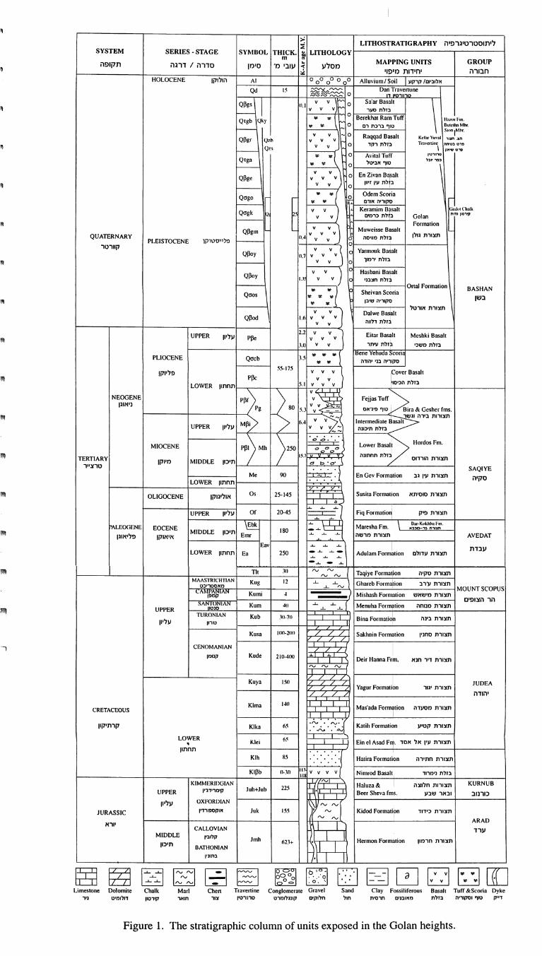
LITHOSז RATIGRAPHYה Iגרפ Iסטרט Iת Iל;.: :;
, LITHOLOGY r. • THICK SYl\-IBOL SERIES • STAGE SYSTEM
GROUP MAPPING UNITS .. m
מסלע..
פה Iתקדרגה /סדרהמו Iסמ'בן IעI חI דI מתIlpl
« בוi:רה Iחב
HOLOCENEחולוקן Allu\'ium 00000000 AIו $ oilקרקעכ'Dוו Iאל
Travenune םri D """'"~ 5 וQd ~~~ oדןרט'ו IIט'
\ Sa'ar Basnll o ~ v v 11,1 I ~ עסר~זלת"" v v v rוBerekhal Ram Tu 0 ... . rl;m ןt וal ן
0 :
... Qז gb Qk'נ
. Mhr הaDuh:il רסכרכחטוף... ... .Ioז I ~ו" Sit -
Kcr nll ~ Raqqad B -0 v vץםu\'a! rרנ v v v ~' Q Qpgrצnצת. v \ v 0רקדזלח P'ר i m\'Cזr~בטהחוםרט
" Q ישארטסP - ... ... r Avilal Tllff 0רטרnט"בלכרפ
אכ'טלטוףga זQ
\ 0 ... ... -
En Zivan B1sall 0 \ , v v v v v QPge
ו lI'rע'ולחכ0 v v
OdemScona ... ... 0 ( Qago
... ...אודטריה Iםקtk וaך(וtdו. u;1 sall 0ו Keramim ) v v
5 ~ r Qagk קטoרP גדI חGolan ,כרמלחכD' v v ion וForma
I .וMuweisse Bas בV V Qpgm PLE 0ו STOCENEפלייסטיקן V V 0מוייטהבזלת V V 11.4 V QUATERNARYגולוצתורת
k OJal1 וnol וrYa V V קוורטר0 v V V .7 וןQPoy
V V 0'רמוךכזלח
all ~ Hasbani B 0 ) V V
v v .\ .. 1 QPoy 0חצכג'זלח
BASHAN aI Formalion Orו a וi~ Slteivan SC ... ...
Qaos ... ... ...בשן ... ...שוכוםקוריה
אורטלתצורת1 ~ Dalwe Bas v v
d דלוזלחI הv v v 6 ו.QPod
V v
Meshki 8asall Eilar 8asall ךV V 2.2 UPPERעליוו
ע'חר~זלח) v v Y PPe
V V ) 3.1משכ'כזלחcon ~ a נcl:Iene Yehu , ... ... ... 3.5 Qacb PLIOCENE
... ...יהודה Iבנסקיר'ה8asall זCove V V V
55ו· 75פליוקו
V v PPcהכיטויןבזלתV V v .חחחוו 5וLOWER
r ~ Fejjas Tuff ~:: ~ PP)p NEOGENE
. 8ira & Geslter fms : 5.3פ'נ'אסטוף Pg ניאוגו
Iוגשרבירהצתורות
::} v MPY Inlermediale 8asall 6.4
-- UPPERעליוו V V V-ת'כונהבזלת 00 • ....... ו..<:ן '""""''''
"~) ' M )~ יוMIOCENE חחחוגהכזלחהורדוטתצורת " " " " "
j .". כIחיכווMIDDLE מיוקוTERTIARY
םר IIטרצ SAQIYE \ . . . .
קיה En Gev Form ~.~ 90 Me Oד lionגבע'ותצורת LOWER Iחחחוו
OLIGOCENEאוליגוקו Susila Formalion 25-145 OSטוט'תאצתורחa
~ Fiq Formalio .......... -:'::.
..... ..... UPPERעליוו r:::= 20-45 Of:==פ'קחצורת. bar·K"khh:l f"m \ ז::::c . ..... ~ רנצתn רבכוכ-בא. MareshaFm ..... _
~ EOCENE Lr:OGr:NEו 80מרשהתצורת MIDDLE AVEDATחיכוו
............... Emr פליאוגואיאוקו
I , ..... ..... ..... Eav
עבדת LOWERחחחוו Adulam Formalion ~-'--L..L. -: 250 Enעדולטצתורת
..... -..... - Taqiye Formalionטק'התצורת
rv rv 311 I ח rv rv
lion ~ Ghareb Form ) ..L.rvע'רבתצורת..L. 2 וKug AN וCH'r ו'R ךMAAS
MOUNT SCOPUS ..L. מאסטרI כט
LAו~~~יר Kumi I\N 4י Mishash Formalion Iמישאשתצורתהצופיםהר
..L. ..L. AN ו~?~ SA מגוחהחצורתlion דיnוMenuha For ..L. ..L. 411 Kum
UPPER TURONו 8ina Formaliof, 1(1-7(1 . Kub ANביגהתצורת
עליווטורוו
Ul-2I " Kusaא Sakhnin Formalion // / lטחג'וחצורת/ /
I
AN וCENOMAN L.
.L .L וll-4IK 2ו Kude קגומו Deir Hanna Frm •חגאדירתצורת
rv rv '"
Yagur Formalibn
/ L.L.L l ו 5וKllya JUDEA
יגורתצורת
/ / / /,יהודה
Mas'ada FOrmjliOn 4Il וKlma
CRETACEOUSמטעדהתצורת
...ג~ ."" . ,"". Kalih Formaו ionקט'עתצורת
~ 6 Klka קרתיקון ..... • .rv •
K LOWERו Ein el Asad F ~ 6 ; e'ייזאסדאלע'ןחצורח•
I חחתוו
Kו Halira Formalion 85 hחתירהתצורת
KIPbו .Nimrod 8asall V V v V ~ II (I ~ l ,ג'מרודכזלח118
KURNUB חלוצהחצורוחI rv JGlAN ווM!'o1ER וK & Haluza . 225 Juh+Jub רלמריד'ניןUPPER 8 .שבעובארכורנובeer Sheva fms
rv rv ~ I AN וJ וOXFOR עליון
JURASSICאוקםפורד'ו Jukו Kidod Formalirn rv 55כ'דודתצורחrv rv
ARAD I יורא
CALLOV1ANערד
I Jmh קיוב'וMIDDLE Hermon Formalionחרמוןתצורת
1 11 ' תיכוו +623 AN 8וATHON
I ·בחכויוו
~
~
11
I!I
I!I
I!!!
liI
liIIf
liIIf
II1II
liI
liI
'" ר
rוrרr;-;ך L\1.J ~
Turr &Scoria Dyke וסקוריהטוףדמק
~ ~
I וBasa בזלח
cפ~ D ~ I ~ E g ~ ~ 0 " .. .' . 0 . = 0 rv rv
Gravel Conglomerale Travenine Chen Marl n לוקO' טרקוננלומרטII וחארצוררט'ו
~~~ irerous וClay Fossi Sand
חולרחם'ח 'Oמאוכג
Chalk Dolomile Limestone נ'רדלוומ'טק'רםוו
Figure 1. The stratigraphic column of units exposed in the Golan heights.
I'~I.
38 r III1!ן
הגולושללגיאולוגיההערות
וקצריןאודםהרגליונות 1 : 50,000מידהבקנההגיאולוגיותהמפותעל(מבוטט
מור)וד.מיכלטוןח.מאתגמלאוגליוןמורד.מאתr'י l
i מאת
r c'
טנהוע.גולדברגמ.היימן,א.מימרן,י.דרוקמן,י.ח.מיכלטון,מור,.ד
-תקצירוגמלאקצריןאודם,הרגליונותבתזוומיהגולןברמתהחשופותהגיאולוגיותהיזוידות
השייכותיזוידותכוללהטטרטיגרפיהחתךהנוכחי.זו IFהדובמטגרתנידונות } 1 : 50,000 {
קוורטר.ודעיוראמגילחבורותלשמונה
חבורותמטר; 3000כשלכולללעוביומגיעותימיותאוליגוקןודעיוראמגילהיחידות
ואילובלבדהרמהבצפוןנמצאותהצופיםוהריהודההחרמון,במבנהחשופותוכורנובערד
הערוציםמצוקיאתבונותטקייהחבורתשלהתזותוניםוהזולקיםבעדתזובורתיחידות
הרמה.בדרוםהחותרים
יבשתייםדקות,שכבותמטפרלמעטטקייה,חבורתשלמיוקו,מגילהעליונים,החלקים
מטר. 300למג;עועוביים
בשוחבורתשלמטרים,למאותהמגיעמשתנה,בעוביבבדלותמכוטההטדימנטריהזותך
והןהגולןרמתשלהוולקניהפלטואתבונותהחבורהיזוידותפליו-פלייסטוקו.שגילה
ופירוקלסטים.בדלותכיללות
לרמה.ממערבבבקעהמלזויםזובורתמשקעיהצטבריבמקביל,
~
f!III
יי'
,-י!
r !ייI I
i
r r L
Iי' , i
iי-I
18"
הלאןמיןתהתשתיןתמשרד
הגיאןלןגיהמכןו 30ישראלמלכירח'
ישראל , 95501ירןשלים
Te [ .. 972-2-5314211טל. Fax . 972-2-5380688 .פקס
Geological Survey of Israel istry of National Infrastructll1"eS ךThe Mil
. 30 Malkhe Israel St ] 95501 Jel"Usa]em, Israe