Embed Size (px)
Citation preview

3800-PM-BCW0405b Rev. 12/2017 COMMONWEALTH OF PENNSYLVANIA Application DEPARTMENT OF ENVIRONMENTAL PROTECTION
BUREAU OF CLEAN WATER
- 1 -
OFFICIAL USE ONLY
NPDES Permit ID #
Date Received
NOI Complete Date
Issue Date
Effective Date
Expiration Date
NOTICE OF INTENT FOR COVERAGE UNDER THE GENERAL (PAG-02) NPDES PERMIT
OR APPLICATION FOR AN INDIVIDUAL NPDES PERMIT FOR STORMWATER DISCHARGES
ASSOCIATED WITH CONSTRUCTION ACTIVITIES
PLEASE READ THE PERMIT SUMMARY SHEET AND INSTRUCTIONS PROVIDED IN THIS PERMIT APPLICATION PACKAGE BEFORE COMPLETING THIS FORM. COMPLETE THE ATTACHED CHECKLIST AND APPROPRIATE WORKSHEETS.
PLEASE PRINT OR TYPE INFORMATION IN BLACK OR BLUE INK.
PERMIT TYPE GENERAL INDIVIDUAL
APPLICATION TYPE NEW RENEWAL MAJOR MODIFICATION PHASED
SECTION A. APPLICANT INFORMATION
Corporations for profit, corporations not-for-profit, limited liability companies, partnerships or sole proprietorships, limited partnerships, professional associations and business or statutory trusts that were not created or formed under the laws of Pennsylvania desiring to do business in this Commonwealth must register with the Pennsylvania Department of State.
Applicant/Organization Name Phone
FAX
Mailing Address City State ZIP + 4
Supplemental Mailing Address (if needed)
Employer ID (EIN)
Email Address
Contact Name Contact Title
Contact Phone Contact Email Address
Co-Applicant/Organization Name Phone
FAX
Mailing Address City State ZIP + 4
Supplemental Mailing Address (if needed)
Employer ID (EIN)
Email Address
Contact Name Contact Title
Contact Phone Contact Email Address

3800-PM-BCW0405b Rev. 12/2017 Application
- 2 -
SECTION B. PROJECT INFORMATION
1. Project Name:
2. Total Project Site (Acres): 3. Total Disturbed Area (Acres):
4. Project Description:
5. Project Location or Physical Address:
Address City State ZIP + 4
Supplemental Address (If needed)
6. Project County Project Municipality City Boro Twp
7. Type of Ownership:
County Government Municipality (local) School District
Federal Facility (U.S. Government) Non-Government State Government
Mixed Ownership (e.g. Public/Private)
8. Project Latitude: / '/ " Project Longitude: / '/ "
8a. Collection Method: EMAP HGIS GISDR ITPMP GPS WAAS LORAN
8b. Horizontal reference datum (or projection datum) employed in the collection method. (EMAP has a known datum of WGS84 and HGIS (PNDI) has a known datum of NAD83) NAD27 NAD83 WGS84 (GEO84)
Enter the date of collection if the latitude and longitude coordinates were derived from GPS, WAAS or LORAN.
mm dd yyyy
9. U.S.G.S. Quad Map Name(s)
10. Primary NAICS Code (check one):
236115 New Single-Family Housing Construction (except For-Sale Builders)
236116 New Multifamily Housing Construction (except For-Sale Builders)
236117 New Housing For-Sale Builders
236210 Industrial Building Construction
236220 Commercial and Institutional Building Construction
237110 Water and Sewer Line and Related Construction
237120 Oil and Gas Pipeline and Related Structures Construction
237130 Power and Communication Line and Related Structures Construction
237310 Highway, Street, and Bridge Construction
237990 Other Heavy and Civil Engineering Construction
Other Primary NAICS Code (specify)
11. Additional NAICS Code(s) (list all additional codes that apply from the list above):
SECTION C. SITE ANALYSIS
1. Existing and Previous Uses of the Project Site:
1a. Existing Land Uses:
Agriculture % Forest/Woodland % Barren %
Urban % Brownfield % Other %

3800-PM-BCW0405b Rev. 12/2017 Application
- 3 -
1b. Historical Land Uses:
Agriculture % Forest/Woodland % Barren %
Urban % Brownfield % Other %
2. Potential Toxic or Hazardous Pollutants: N/A
Pollutant Concentration
w/Units Source Sample Type Date(s) / Number
of Samples
3. Fill Material
Will the applicant need to import or export fill for the project site? Clean fill can not be placed in or on waters of the Commonwealth. If fill will be imported or exported, Form FP-001 (Document # 258-2182-773) must be used to certify origin of the fill material.
Check the appropriate box
Import fill – the applicant will, in most situations, be responsible to perform environmental due diligence and determine that all fill imported to the site meets the department's definition of clean fill. The plan designer must include a note on the drawings to identify the operator(s) responsibility and provide the definition of Clean Fill and Environmental Due Diligence.
Export fill – the Applicant is responsible for performing environmental due diligence at the time this application was submitted to determine that any fill exported from the site will be certified as clean fill.
Balance all cuts and fills with the amount of rock and soil available on the site.
4. Estimated Timetable for Phased Projects (Complete for phased projects only)
Phase No. or Name Proposed Type of Activity Total Area
Disturbed Area Start Date End Date
5 Waters to Which Project Discharges (Check all that apply)
5.a. Waters of the Commonwealth to which the project discharges or has the potential to discharge to (including EV wetlands) other than MS4s, CSOs, private storm sewers:
Name of Waters Designated Use of Water Existing Use of Water
Combined Sewer Overflow System to which the project discharges:
Municipal Separate Storm Sewer (MS4) to which the project discharges:
Private Storm Sewer to which the project discharges:
Non Surface Water: (including off-site discharges):
5b. Does the site discharge to waters classified as impaired according to Category 4 of PA Integrated Water Quality Monitoring and Assessment Report? Yes No
If yes, list source and cause of impairment:
5c. Does the site discharge to waters with a TMDL according to Category 5 of the PA Integrated Water Quality Monitoring & Assessment Report? Yes No
If yes, list source and cause of impairment TMDL addresses:

3800-PM-BCW0405b Rev. 12/2017 Application
- 4 -
SECTION D. EROSION & SEDIMENTATION (E&S) AND POST CONSTRUCTION STORMWATER MANAGEMENT (PCSM)
Note: For projects involving multiple points of discharge, please submit a complete, separate Section D for each additional point of discharge.
1. E&S Plan - The E&S Plan must satisfy at least one of subparagraph A or B below.
A. E&S plan is designed using BMPs in the Pennsylvania Erosion & Sedimentation Pollution Control Manual (ESPC) (Technical Guidance #363-2134-008/March 2012)
OR
B. E&S plan is designed using an alternative BMP or design standard
2. PCSM Plan
The PCSM Plan must satisfy either subparagraph A, or B or C below.
A. Act 167 Plan approved on or after January 2005 – The attached PCSM Plan, in its entirety, is consistent with all requirements pertaining to rate, volume, and water quality from an approved Act 167 Stormwater Management Plan.
Complete the following table for all applicable approved Act 167 Stormwater Management Plans. (use additional sheets if necessary)
ACT 167 Plan Name Date Adopted Consistency Letter Included
Consistency Letter Pending
If the PCSM Plan is consistent with a DEP approved Act 167 plan from 2005 or later and the Act 167 plan is without variance consistent with the standard design criteria from the 25 Pa. Code Chapter 102.8(g)(2) and (3) then utilizing worksheets 1-5 and the Summary table for Supporting Calculation and Measurement Data are recommended, otherwise check the applicable box(es) in Section D.3
OR
B. The PCSM Plan meets the standard design criteria from the 25 Pa. Code Chapter 102.8(g)(2) and (3).
OR
C. Alternative Design Standard – The attached PCSM plan was developed using approaches other than those in 25 Pa. Code Chapter 102.8(g)(2) and (3). Demonstrate how this standard will be either more protective than what is required in 25 Pa. Code Chapter 102.8(g)(2) and (3). and will maintain and protect existing water quality and existing and designated uses as allowed in 102.8(g)(2)(iv) and 102.8(g)(3)(iii).

3800-PM-BCW0405b Rev. 12/2017 Application
- 5 -
3. Summary Table for Supporting Calculation and Measurement Data
Not Applicable in accordance with 102.8(g)(2)(iv)- provide supporting calculations and documentation in the Narrative. If checked, proceed to Peak Rate Analysis (provide supporting details to include a summary, calculations, and a statement and demonstration of attainment in the Narrative- Reference the Instructions for a General (PAG-02) OR Individual NPDES Permit for stormwater discharges associated with construction activities Section D)
Not Applicable PCSM Plan satisfies an Act 167 Plan approved on or after January 2005, in its entirety- provide supporting calculations and documentation in the Narrative. If checked proceed to Section D.4 (provide supporting details to include a summary, calculations and a statement and demonstration of attainment in the Narrative- Reference the Instructions for a General (PAG-02) OR Individual NPDES Permit for stormwater discharges associated with construction activities Section D)
Please reference the stormwater methodology used (Numbers generated in the table below should be consistent with Worksheets 3,4, and 5 and be accompanied by supporting calculations in the Narrative)
Pre-construction Post Construction Net Change
Design storm frequency
Rainfall amount inches
Impervious area (acres)
Volume of stormwater runoff acre-feet or cubic feet (check appropriate box)
Volume of stormwater runoff acre-feet or cubic feet (check appropriate box)
Peak Rate Analysis: Complete Boxes 9-20 (Numbers generated in table should be accompanied by supporting calculations in the narrative)
Exempt in accordance 102.8(g)(3)(ii), Complete Boxes 9-20
Not Applicable in accordance with 102.8(g)(3)(iii)
{If any of the above is checked, provide supporting calculations and documentation in the Narrative}
Stormwater peak discharge rate for the 2-year/24-hour storm (cubic feet per second (cfs))
Stormwater peak discharge rate for 10-year/24-hour storm (cfs)
Stormwater peak discharge rate for 50-year/24-hour storm (cfs)
Stormwater peak discharge rate for the 100-year/24-hour storm
Box 1. Pre-construction impervious area: The total acres of impervious area on the project site before construction activities begin, based on land use for five years preceding the planned project.
Box 2. Post construction impervious area: The total acres of impervious area on the project site after construction activities have been completed.
Box 3. Net change of impervious area: The change in the impervious area (acres) listed in Box 1 and Box 2. Zero or negative values are acceptable. (Box 2- Box 1)
Box 4. Pre-construction stormwater runoff volume: The amount of stormwater runoff volume from the project site that would result from the design storm occurrence before construction activities begin based on land use for five years preceding the project.
Box 5. Post construction stormwater runoff volume: The amount of stormwater runoff volume from the project site that would result from the design storm occurrence after construction activities have finished assuming that no non-structural/structural BMP(s) have been installed.
Box 6. Net change in stormwater volume: The change in stormwater runoff volumes listed in Box 4 and Box 5. (Box 5 - Box 4)
Box 7. Post construction stormwater runoff volume reduction: The amount of stormwater runoff volume reduction that would result from the planned non-structural/structural BMP(s) installation. (Total non-structural volume credit (from worksheet 3) + Total Structural volume (from worksheet 5) ))
1 2 3
6 5 4
9
7 8
11 10
12 13 14
15 16 17
18 19 20

3800-PM-BCW0405b Rev. 12/2017 Application
- 6 -
Box 8. Net change in stormwater runoff volume with planned BMPs: The change in stormwater runoff volume and volume reduction listed in Box 6 and Box 7. (Box 6 – Box 7)
Figures contained in the “Summary table for supporting calculation and measurement data” should be consistent with those on Worksheets 3, 4, and 5, when applicants have utilized the Stormwater Best Management Practices (BMP) Manual to meet design standards. Below is a depiction of which worksheet(s) corresponds (i.e. WKST 4) to each Box and where on the worksheet to find the information (i.e. 2-Year Volume Increase).
Box 9. Pre-construction stormwater discharge rate: The stormwater runoff discharge rate for the 2-year/24-hour storm as determined by the land use for the past five years.
Box 10. Post construction stormwater discharge rate: The stormwater runoff discharge rate for the 2-year/24-hour storm after all planned stormwater BMPs are installed.
Box 11. Net change stormwater discharge rate: The change in stormwater runoff discharge rates listed in Box 9 and Box 10. (Box 10 – Box 9)
Box 12. Pre-construction stormwater discharge rate: The stormwater runoff discharge rate for the 10-year/24-hour storm as determined by the land use for the past five years.
Box 13. Post construction stormwater discharge rate: The stormwater runoff discharge rate for the 10-year/24-hour storm after all planned stormwater BMPs are installed.
Box 14. Net change stormwater discharge rate: The change in stormwater runoff discharge rates listed in Box 12 and Box 13. (Box 13 – Box 12)
Box 15. Pre-construction stormwater discharge rate: The stormwater runoff discharge rate for the 50-year/24-hour storm as determined by the land use for the past five years.
Box 16. Post construction stormwater discharge rate: The stormwater runoff discharge rate for the 50-year/24-hour storm after all planned stormwater BMPs are installed.
Box 17. Net change stormwater discharge rate: The change in stormwater runoff discharge rates listed in Box 15 and Box 16. (Box 16 – Box 15)
Box 18. Pre-construction stormwater discharge rate: The stormwater runoff discharge rate for the 100-year/24-hour storm as determined by the land use for the past five years.
Box 19. Post construction stormwater discharge rate: The stormwater runoff discharge rate for the 100-year/24-hour storm after all planned stormwater BMPs are installed.
Box 20. Net change stormwater discharge rate: The change in stormwater runoff discharge rates listed in Box 18 and Box 19. (Box 19 – Box 18)

3800-PM-BCW0405b Rev. 12/2017 Application
- 7 -
4. Summary Description of Post Construction Stormwater BMPs (consistent with the design or applicable worksheets)
Key: RC = Rate Control VC = Volume Control WQ = Water Quality
In the lists below, check the BMPs identified in the PCSM Plan, and their function(s) using the above Key. More than one function may be checked for a BMP. A BMP may have more than one function (rate, volume, water quality), therefore, there may be more than one volume/acres listed. For example, a Rain garden/Bio-retention BMP may have a volume treated and acres treated for volume control and water quality, that differs from the volume treated and acres treated for rate control. If any BMP in the PCSM Plan is not listed below, it must be described in the space provided after “Other”. Attach additional sheet(s) as needed
For Rate Control provide the volume of stormwater treated and acres treated for the 100-year/24-hour storm event
For Volume Control and Water Quality provide the volume of stormwater treated and acres treated for the 2-year/24-hour storm event
BMP Function(s) Volume of stormwater
treated Acres treated
Wet ponds VC RC WQ
Constructed wetlands VC RC WQ
Retention basins VC RC WQ
Detention basin VC RC WQ
Underground detention VC RC WQ
Dry Extended detention basin VC RC WQ
Sediment fore bay VC RC WQ
Infiltration trench VC RC WQ
Infiltration Berm/Retentive Grading VC RC WQ
Subsurface Infiltration bed VC RC WQ
Infiltration basin VC RC WQ
Pervious pavement VC RC WQ
Dry well/Seepage pit VC RC WQ
Bio-infiltration areas VC RC WQ
Rain gardens/Bio-retention VC RC WQ
Vegetated swales VC RC WQ
Constructed filters VC RC WQ
Protect Sensitive & Special Value Features VC RC WQ
Protect/Convert/Establish Riparian buffers VC RC WQ
Restoration: Buffers/ Landscape/Floodplain VC RC WQ
Disconnection from storm sewers VC RC WQ
Rooftop disconnection VC RC WQ
Vegetated roofs VC RC WQ
Runoff capture/Reuse VC RC WQ
Oil/grit separators WQ
Water quality inserts/inlets WQ
Street sweeping WQ
Other VC RC WQ
Other VC RC WQ

3800-PM-BCW0405b Rev. 12/2017 Application
- 8 -
5. Off Site Discharge Analysis
Does the project propose any off-site discharges to areas other than surface waters? Yes No
If yes, the applicant must have appropriate easement that provides the legal authority for this off-site discharge. In addition, applicant must provide a demonstration in both the E&S and PCSM plans that the discharge will not cause erosion, damage, or nuisance to off-site properties.
6. Potential Pollution Causing Materials
Identify naturally occurring geologic formations or soil conditions that may have the potential to cause pollution during earth disturbance activities and include BMPs to avoid or minimize potential pollution and its impacts from the formation.
7. Riparian Buffers
A. Does the project discharge to a river, stream, creek, lake, pond or reservoir with a designated use of high quality or exceptional value? If so, is earth disturbance occurring within 150 feet of the river, stream, creek, lake, pond or reservoir?
Yes No
If yes, go to B. If no, continue to Section 8.
B. Will you be protecting, converting, or establishing a 150 foot riparian buffer throughout the project area?
Protect Yes No Convert Yes No Establish Yes No
If No to all above, the application must contain a demonstration of riparian buffer or riparian forest buffer equivalency. (Continue to C)
C. What BMPs will you be using that will be functionally equivalent to that of either a riparian buffer or a riparian forest buffer whatever is applicable to the project? Please attach an equivalency demonstration.
An equivalency demonstration must be completed, including worksheets 12-15 and a narrative that shows that the alternative BMPs implemented will be functionally equivalent to that of either a riparian buffer or a riparian forest buffer, whichever is applicable to the project according to 102.14(a)(1) and (2).
D. Will the project propose any earth disturbance within 100 feet of a surface water? Yes No
If yes, the applicant shall provide an offset riparian forest buffer at a ratio of one to one for the disturbed area.
8. Thermal Impacts Analysis
Explain how thermal impacts associated with this project were avoided, minimized, or mitigated.

3800-PM-BCW0405b Rev. 12/2017 Application
- 9 -
9. Critical Stages
Identify the critical stages of implementation of the PCSM plan for which a licensed professional or designee shall be present on the project site.
SECTION E. ANTIDEGRADATION ANALYSIS MODULE
This Section is to be completed for Special Protection Waters Only (Projects that drain to HQ/EV Waters and EV Wetlands).
PART 1 NONDISCHARGE ALTERNATIVES EVALUATION
E & S Plan
Official Use Only PCSM Plan
Official Use Only
Check off the environmentally sound nondischarge Best Management Practices (BMPs) listed below to be used prior to, during, and after earth disturbance activities that have been incorporated into the E & S Plan based on the site analysis. For BMPs not checked, provide an explanation of why they were not utilized, attach additional sheets if necessary.
Check off the environmentally sound nondischarge Best Management Practices (BMPs) listed below to be used after construction that have been incorporated into the PCSM Plan based on the site analysis. For BMPs not checked, provide an explanation of why they were not utilized, attach additional sheets if necessary.
Nondischarge BMPs
Alternative Siting
Alternative location
Alternative configuration
Alternative location of discharge
Limited Disturbed Area
Limiting Extent & Duration of Disturbance (Phasing, Sequencing)
Riparian Buffers (150 ft min)
Riparian Forest Buffer (150 ft min)
Other*
Nondischarge BMPs
Alternative Siting
Alternative location
Alternative configuration
Alternative location of discharge
Low Impact Development (LID / BSD)
Riparian Buffers (150 ft min)
Riparian Forest Buffer (150 ft min)
Infiltration
Water Reuse
Other*
* Identify any and all best management practices, design standards and alternatives that collectively are substantially equivalent to a riparian buffer or riparian forest buffer in effectiveness, to minimize the potential for accelerated erosion and sedimentation and to protect, maintain, reclaim and restore water quality and for existing and designated uses of a perennial or intermittent river, stream or creek or lake, pond or reservoir of this Commonwealth to ensure compliance with 25 Pa. Code Chapter 93 (relating to water quality standards).
Will the nondischarge alternative BMPs eliminate the change in rate, volume, or quality during construction? Yes No If yes, the antidegradation analysis is complete. If no, proceed to Part 2.
Will the nondischarge alternative BMPs eliminate the change in rate, volume, or quality after construction? Yes No
If yes, the antidegradation analysis is complete.
If no, proceed to Part 2.

3800-PM-BCW0405b Rev. 12/2017 Application
- 10 -
Part 2 Antidegradation Best Available Combination of Technologies (ABACT)
If the net change in stormwater discharge during or after construction is not fully eliminated by nondischarge BMPs, the applicant must utilize ABACT BMPs to manage the change. The applicant must specify whether the discharge will occur during construction, post-construction or both, and identify the technologies that will be used to ensure that the discharge will be a non-degrading discharge.
E & S Plan
Official Use Only PCSM Plan
Official Use Only
Treatment BMPs:
Sediment basin with skimmer
Sediment basin ratio of 4:1 or greater (flow length to basin width)
Sediment basin with 4-7 day detention
Flocculants
Land disposal:
Vegetated filters
Riparian buffers <150ft.
Riparian Forest Buffer <150ft.
Pollution prevention:
PPC Plans
Immediate stabilization
Street sweeping
Channels, collectors and diversions lined with permanent vegetation, rock, geotextile or other non-erosive materials
Stormwater reuse technologies:
Sediment basin water for dust control
Sediment basin water for irrigation
Other*
Treatment BMPs:
Infiltration Practices
Wet ponds
Created wetland treatment systems
Vegetated swales
Manufactured devices
Bio-retention/infiltration
Green Roofs
Land disposal:
Vegetated filters
Riparian Buffers <150ft.
Riparian Forest Buffer <150ft.
Pollution prevention:
Disconnection of roof drainage
Bio-retention/bio-infiltration
Street sweeping
Nutrient, pesticide, herbicide or other chemical application plan alternatives
PPC Plans
Non-structural Practices
Land Preservation
Restoration BMPs
Stormwater reuse technologies:
Cisterns
Rain barrels
Dry hydrant with underground storage
Spray/Drip Irrigation
Other*
* Identify any and all best management practices, design standards and alternatives that collectively are substantially equivalent to a riparian buffer or riparian forest buffer in effectiveness, to minimize the potential for accelerated erosion and sedimentation and to protect, maintain, reclaim and restore water quality and for existing and designated uses of a perennial or intermittent river, stream or creek or lake, pond or reservoir of this Commonwealth to ensure compliance with 25 Pa. Code Chapter 93 (relating to water quality standards).
Are the ABACT BMPs selected sufficient to minimize E & S discharges to the extent that existing or designated surface water uses are protected?
Yes If yes, antidegradation analysis is complete.
No If no, and the project discharges to a HQ water, proceed to Part 3. If no and the project discharges to an EV Water, contact the local conservation district or Department regional office.
Are the ABACT BMPs selected sufficient to manage the net change and assure that existing or designated surface water uses are protected?
Yes If yes, antidegradation analysis is complete. No If no, and the project is located in a HQ
water, proceed to Part 3. If no and the project discharges to an EV Water, contact the local conservation district or Department regional office.
Part 3 Social or Economic Justification (SEJ) (for projects in high quality waters only)
If the project discharges to HQ waters only, is there an important economic or social justification for the project?
Yes No If yes, please contact the Department regional office for the county in which the project is located.

3800-PM-BCW0405b Rev. 12/2017 Application
- 11 -
SECTION F. CONSULTANT FOR THIS PROJECT
Plan Preparer’s Name eFACTS Consultant ID
Title Consulting Firm Seal (if applicable)
Mailing Address
City State ZIP+4
Email Phone Ext
FAX
SECTION G. COMPLIANCE HISTORY REVIEW
Is/was the applicant(s) in violation of any Department regulation, order, schedule of compliance or permit or in violation of any Department regulated activities within the past five years?
Yes No
If yes, list each permit order, schedule of compliance or project that is/was in violation and provide compliance status of the activity (use additional sheets to provide information on all permits).
Permit Program or Activity: Permit Number (if applicable):
Brief description of non-compliance:
Steps taken to achieve compliance
Date(s) compliance achieved
Current Compliance Status: In-Compliance In Non-Compliance
If in non-compliance, please attach schedule for achieving compliance.

3800-PM-BCW0405b Rev. 12/2017 Application
- 12 -
SECTION H. PERMIT COORDINATION
1. Are there pending permits or any other permits, approvals or planning requirements for this project?
Yes No If yes, list each permit or approval, permit number, and description.
2. Does the project involve any of the following: placement of fill and/or excavation within or a placement of a structure located in, along, across, or projecting into a water course, floodway or body of water (including wetlands)?
Yes No If yes, identify which authorization under Chapter 105 is applicable.
Joint Permit General Permit Waiver
3. What is the project’s 537 Plan status? Please note that 537 Plan approval is required prior to initiation of earth disturbance activity.
4. Is the project associated with a brownfield remediation and/or requires an Act 2 approval? Yes No If yes, please indicate any coordination to date with the Department’s Environmental Cleanup Program.

3800-PM-BCW0405b Rev. 12/2017 Application
- 13 -
SECTION I. CERTIFICATION
Applicant Certification
I certify under penalty of law that this application and all related attachments were prepared by me or under my direction or supervision in accordance with a system designed to assure that qualified personnel properly gather and evaluate the information submitted. Based on my own knowledge and on inquiry of the person or persons directly responsible for gathering the information, the information submitted is, to the best of my knowledge and belief, true, accurate and complete. The responsible official’s signature also verifies that the activity is eligible to participate in the NPDES permit, and that BMP’s, E&S Plan, PPC Plan, PCSM Plan, and other controls are being or will be, implemented to ensure that water quality standards and effluent limits are attained. I am aware that there are significant penalties for submitting false information, including the possibility of fine and imprisonment or both for knowing violations pursuant to Section 309(c)(4) of the Clean Water Act and, 18 Pa. C.S. §§4903-4904.
I grant permission to the agencies responsible for the permitting of this work, or their duly authorized representative to enter the project site for inspection purposes. I will abide by the conditions of the permit if issued and will not begin work prior to permit issuance.
(For individuals no indication of title is necessary, choose the box below. All others proceed to the next paragraph)
Individual; proceed to signature portion.
I hereby certify that I am the signatory pursuant to 25 Pa, Code § 92a.22 and 40 CFR §122.22 and that I am the person who is responsible for decision-making regarding environmental compliance functions for Enter Entity name, the manager of one or more manufacturing, production, or operating facilities of the applicant and am authorized to make management decisions which govern the operation of regulated facility including having explicit or implicit duty of making major capital investment recommendations, and initiating and directing other comprehensive measures to assure the applicant’s long term environmental compliance with environmental laws and regulations; and I am responsible for ensuring that the necessary systems are established or actions taken to gather complete and accurate information for permit application requirements.
(choose one of the following; not applicable for individuals):
The responsible corporate officer president vice president secretary treasure of Corporation/Company
Entity name
The member or manager of LLC
Entity name
The general partner of partnership/LP/LLP
Entity name
The principal executive officer or ranking elected official of Municipality/State/Federal/other public agency
Entity name
Power of Attorney/delegation of contractual authority (documentation supporting delegation of contracting authority must be provided) for
Entity name
SIGNATURES
Applicant Co-Applicant (if applicable)
Print Name and Title of Person Signing Print Name and Title of Person Signing
Signature of Applicant Signature of Co-Applicant
Date Signed Date Signed
Please note below the name, address and telephone number of the individual that should be contacted in the event additional information is required.
Name Phone
FAX

3800-PM-BCW0405b Rev. 12/2017 COMMONWEALTH OF PENNSYLVANIA Checklist DEPARTMENT OF ENVIRONMENTAL PROTECTION
BUREAU OF CLEAN WATER
- 1 -
COMPLETENESS REVIEW CHECKLIST
Check-off: C = Complete, NC = Not Complete
STANDARD E & S AND PCSM COMPLETENESS REVIEW CHECKLIST
General Applicant Reviewer
Item Item
Location Included Page
Number C NC
Fully completed and properly signed Notice of Intent Form (1 original and 2 copies)
Permit filing fee of $500 (general permit) or $1500 (individual permit) payable to the appropriate Clean Water Fund
Disturbed acre fee payable to the Commonwealth of Pennsylvania Clean Water Fund
Proof of receipt of municipal and county Acts 14, 67, 68, and 127 notifications; copies of certified mail receipts or acknowledgment letters from the local municipality and county government.
A signed PNDI receipt for the project area showing “No Known Impact”, or “Avoidance Measures” or “Potential Impact” and proof of delivery to the appropriate jurisdictional agency(ies) where further coordination is required, as appropriate)
(Reference the Instructions for a General (PAG-02) OR Individual NPDES Permit for stormwater discharges associated with construction activities- Pennsylvania Natural Heritage Program (PNHP) & Pennsylvania Natural Diversity Inventory)
Complete Erosion and Sediment Control Plans (3 copies)
Complete Post Construction Stormwater Management Plan (3 copies)
Fully completed General Information Form (GIF) (Individual Permits
PHMC coordination letter/clearance (Individual Permits for 10 acres or more of disturbance only)
Appendix A land use questions
Item Location: D = E&S Drawings, N = E&S Narrative, D or N = Drawings or Narrative
D & N = Drawings and Narrative
E&S Plan Planning & Design 102.4(b)(4)
Applicant Reviewer
Item Item
Location Included Page
Number C NC
The E&S Plan is separate from the PCSM Plan and labeled ‘‘E&S’’ or ‘‘Erosion and Sediment Control Plan’’ and is the final plan for construction.
D & N
Documentation provided that E&S Plan was prepared by person trained and experienced in E&S design methods and techniques applicable to the size and scope of the project
N
E&S Plan minimizes extent and & duration of earth disturbance D & N
E&S Plan maximizes protection of existing drainage features and vegetation
D & N
E&S Plan minimizes soil compaction D & N
E&S Plan utilizes other measures or controls that prevent or minimize generation of increased stormwater runoff
D & N
Existing topographic features of the project site and the immediate surrounding area §102.4(b)(5)(i)
Applicant Reviewer
Item Item
Location Included Page
Number C NC
Topographic map(s) of the project site provided D
Location map (USGS quadrangle) provided D or N

3800-PM-BCW0405b Rev. 12/2017 Checklist
- 2 -
Types, depth, slope, locations and limitations of the soils §102.4(b)(5)(ii)
Applicant Reviewer
Item Item
Location Included Page
Number C NC
Soil map provided D or N
Soil use limitations and their resolutions provided D or N
Past, present and proposed land uses and proposed alteration to project site §102.4(b)(5)(iii)
Applicant Reviewer
Item Item
Location Included Page
Number C NC
Past land uses for past 50 years addressed N
Present land uses for last 5 years addressed N
Proposed alteration/land uses shown on a plan map D
Volume and rate of runoff from the project site and its upstream watershed area §102.4(b)(5)(iv)
Applicant Reviewer
Item Item
Location Included Page
Number C NC
Drainage area maps provided for proposed channels, basins, and traps
D or N
Runoff calculations provided for proposed channels N
Location of all surface waters and their classification under Chapter 93 §102.4(b)(5)(v)
Applicant Reviewer
Item Item
Location Included Page
Number C NC
Surface waters shown on plan map(s) D
Existing/designated uses of all streams, lakes, ponds, wetlands or other surface waters identified
D or N
Narrative description of the location and type of perimeter and onsite BMPs §102.4(b)(5)(vi)
Applicant Reviewer
Item Item
Location Included Page
Number C NC
E&S BMPs identified/described N
E&S BMPs shown on plan map(s) D
Sequence of BMP installation and removal §102.4(b)(5)(vii)
Applicant Reviewer
Item Item
Location Included Page
Number C NC
Construction sequence provided D
Supporting calculations and measurements §102.4(b)(5)(viii)
Applicant Department
Item Item
Location Included Page
Number C NC
Calculations provided for all proposed channels, traps, and basins N
Standard E&S worksheets or equivalents completely filled out N
Plan drawings §102.4(b)(5)(ix)
Applicant Department
Item Item
Location Included Page
Number C NC
Plan map(s) showing proposed earthmoving provided D
Details and/or typicals provided for each proposed E&S BMP D

3800-PM-BCW0405b Rev. 12/2017 Checklist
- 3 -
Maintenance program §102.4(b)(5)(x)
Applicant Reviewer
Item Item
Location Included Page
Number C NC
Maintenance of proposed BMPs addressed D
Inspection schedule for proposed BMPs provided D
Written report documenting inspections and repairs specified D
Recycling or disposal of materials §102.4(b)(5)(xi)
Applicant Reviewer
Item Item
Location Included Page
Number C NC
Anticipated construction wastes identified D
Instructions provided for proper recycling/disposal of materials provided
D
Geologic formations/soil conditions that may have the potential to cause pollution §102.4(b)(5)(xii)
Applicant Reviewer
Item Item
Location Included Page
Number C NC
Geologic/soil conditions addressed D or N
Where potential for pollution identified, measures provided to avoid/minimize/or mitigate
D
Potential thermal impacts to surface waters §102.4(b)(5)(xiii)
Applicant Reviewer
Item Item
Location Included Page
Number C NC
Potential for thermal impacts addressed D or N
Where potential for impacts exists, measures provided to avoid/minimize/or mitigate
D
E&S Plan designed and implemented to be consistent with PCSM Plan §102.4(b)(5)(xiv)
Applicant Reviewer
Item Item
Location Included Page
Number C NC
Proposed structural PCSM BMPs shown on the E&S plan map(s) D
Existing/proposed riparian buffers outside limits of disturbance D
Proposed infiltration BMPs outside proposed grading areas D
Existing/proposed riparian forest buffers §102.4(b)(5)(xv)
Applicant Reviewer
Item Item
Location Included Page
Number C NC
Existing/proposed riparian forest buffers shown on plan map(s) D
Existing/proposed riparian forest buffers outside limits of disturbance D
Protection provided for wetlands within riparian forest buffer D or N
Riparian buffer offset shown, if necessary D
Antidegradation Analysis
Applicant Reviewer
Item Item
Location Included Page
Number C NC
Equivalency demonstration for alternative BMPs to a riparian buffer or riparian forest buffer
Evaluation of nondischarge alternatives, including demonstration that a nondischarge alternative does not exist for both E&S and PCSM
N
ABACT included where a nondischarge alternative does not exist for both E&S and PCSM
D or N
Nondischarge and ABACT BMPs have been identified for both E&S and PCSM
D or N

3800-PM-BCW0405b Rev. 12/2017 Checklist
- 4 -
Item Location: D = PCSM Drawings, N = PCSM Narrative, D or N = Drawings or Narrative D & N = Drawings and Narrative
General PCSM planning and design 102.8(b)
PCSM Plan - General
Applicant Reviewer
Item Item
Location Included Page
Number C NC
The PCSM Plan is separate from the E&S Plan and labeled ‘‘PCSM’’ or ‘‘Post Construction Stormwater Management Plan’’ and is the final plan for construction.
D & N
Municipal or county engineer consistency letter provided N
Act 167 plan is dated January 2005 or later N
Documentation provided that PCSM Plan was prepared by person trained and experienced in PCSM design methods and techniques applicable to the size and scope of the project
N
Preserve the integrity of stream channels and maintain and protect the physical, biological and chemical qualities of the receiving stream
D or N
Prevent an increase in the rate of stormwater runoff D or N
Minimize any increase in stormwater runoff volume D or N
Minimize impervious areas D & N
Maximize the protection of existing drainage features and existing vegetation
D & N
Minimize land clearing and grading D & N
Minimize soil compaction D or N
Utilize other structural or nonstructural BMPs that prevent or minimize changes in stormwater runoff
D & N
Existing topographic features of the project site and the immediate surrounding area §102.8(f)(1)
Applicant Reviewer
Item Item
Location Included Page
Number C NC
Topographic map(s) of the project site provided D
Location map (USGS quadrangle) provided D
Type of cover D
Types, depth, slope, locations and limitations of the soils and geologic formations §102.8(f)(2)
Applicant Reviewer
Item Item
Location Included Page
Number C NC
Soil map provided D
Soil use limitations and their resolutions provided D or N
Site characterization of soil and geology, including appropriate infiltration and geological studies that identify location, depths, and methodology
D & N
Geologic mapping features addressed where appropriate D or N

3800-PM-BCW0405b Rev. 12/2017 Checklist
- 5 -
Characteristics of the project site, including the past, present and proposed land uses and the proposed alteration to the project site §102.8(f)(3)
Applicant Reviewer
Item Item
Location Included Page
Number C NC
Permit boundaries D
Proposed limits of disturbance D
Proposed contours and grades D
Proposed improvements (i.e. roads, buildings, utilities etc.) D
Past, present and proposed land uses N
Proposed waterways and stormwater management facilities shown on the plan maps
D
Proposed impervious areas minimized & shown on plan map(s) D
Net change in volume and rate of stormwater §102.8(f)(4)
Applicant Reviewer
Item Item
Location Included Page
Number C NC
Design storm used for calculations identified N
Pre- and post-construction hydrology runoff rate and volume are identified for each drainage area of entire project site
N
The net change in runoff rate and volume are identified for each drainage area of the entire project site
N
Summary table in NOI consistent with runoff calculations, when applicants have utilized the manual to meet design standards
N
Documentation summarizing the PCSM requirements (rate, volume, and water quality) for a DEP approved Act 167 plan, if applicable
N
Documentation summarizing the alternative approach’s design criteria for rate, volume and water quality, if applicable
N
Receiving surface waters §102.8(f)(5)
Applicant Reviewer
Item Item
Location Included Page
Number C NC
Existing streams, wetlands, floodways, and watercourses shown on plan map(s)
D
Existing and designated uses identified D or N
Boundaries for HQ or EV watersheds shown on plan map(s) D
Wetland boundaries consistent with delineation report D
Written Description of the PCSM BMPs §102.8(f)(6)
Applicant Reviewer
Item Item
Location Included Page
Number C NC
All permanent PCSM BMPs identified in the narrative and shown on plan drawings
D & N
Specifications for all permanent PCSM BMPs provided D
Proprietary BMP systems are illustrated on the drawings in accordance with their manufacturer’s requirements
D
Sequence of PCSM BMP implementation or installation §102.8(f)(7)
Applicant Reviewer
Item Item
Location Included Page
Number C NC
Complete and site specific sequence of BMP installations provided D
Construction sequence addresses all structural BMPs D
Sequence for individual BMP installation D
Critical stages of BMP installation are identified D
Protection provided for infiltration BMPs until drainage areas completely stabilized
D

3800-PM-BCW0405b Rev. 12/2017 Checklist
- 6 -
Supporting calculations §102.8(f)(8)
Applicant Reviewer
Item Item
Location Included Page
Number C NC
Worksheets from the Stormwater BMP Manual provided when applicants have utilized the manual to meet design standards
N
Figures contained on worksheets consistent with those in NOI/application when applicants have utilized the manual to meet design standards
N
Calculations for all permanent BMPs and points of interest provided N
Methodology used for all calculations is identified. N
Calculations demonstrating that rate, volume, and water quality were met in accordance with 102.8(g)(2)(i-iii) and 102.8(g)(3)(i-ii) AND/OR a DEP approved Act 167 plan OR an alternative approach
Routing analysis to demonstrate peak control for the 2-, 10-, 50-, and 100-year/24-hour storm events, which considers benefits of proposed BMPs provided
N
Plan drawings §102.8(f)(9)
Applicant Reviewer
Item Item
Location Included Page
Number C NC
Locations of all proposed BMPs shown along with tributary drainage areas
D
Existing and proposed discharges & points of interest shown D
PCSM Plan drawings consistent with E&S Plan in relation to proposed contours, improvements, soils, wetlands, floodways, streams, discharge locations, etc.
D
Construction details provided for all PCSM BMPs D
Dimensions and elevations consistent with those used in supporting calculations
D & N
Long-term operation and maintenance schedule §102.8(f)(10)
Applicant Reviewer
Item Item
Location Included Page
Number C NC
Inspection schedule of each permanent BMP is provided D
Directions for maintenance and/or replacement of each BMP provided
D
Recycling or disposal of materials §102.8(f)(11)
Applicant Reviewer
Item Item
Location Included Page
Number C NC
Project wastes identified D
Directions for recycling /disposal of wastes provided D
Geologic formations or soil conditions §102.8(f)(12)
Applicant Reviewer
Item Item
Location Included Page
Number C NC
Potential for geologic or soil conditions to cause pollution during construction identified
N
Instructions for proper handling and/or disposal of all materials which could cause pollution are provided
D
Typical details & instructions provided for proper handling and/or disposal of all such materials
D
Locations of all such materials clearly shown on plan maps D

3800-PM-BCW0405b Rev. 12/2017 Checklist
- 7 -
Potential thermal impacts §102.8(f)(13)
Applicant Reviewer
Item Item
Location Included Page
Number C NC
Description provided of how thermal impacts of stormwater runoff from project site were avoided, minimized, or mitigated
N
Riparian forest buffer management plan §102.8(f)(14)
Applicant Reviewer
Item Item
Location Included Page
Number C NC
Existing and/or proposed riparian forest buffers shown on plan map(s)
D
Impairment and TMDL status of the receiving water(s) for the project indicated
N
Riparian buffer offset areas shown, if necessary D & N
Riparian buffer or riparian forest buffer equivalency demonstration included, if necessary
D & N
Checklist for functional equivalency of riparian buffers and riparian buffers included
N

3800-PM-BCW0405b Rev. 12/2017 Checklist
- 8 -
COMPLETENESS ITEMS BY PERMIT TYPE
Check-off: C = Complete, NC = Not Complete
Item Location: D = E&S/PCSM Drawings, N = E&S/PCSM Narrative, D or N = Drawings or Narrative D & N = Drawings and Narrative
CHECKLIST FOR NEW NPDES PERMITS
Applicant Reviewer
Item Item
Location Included Page
Number C NC
1. All items included in the standard E&S and PCSM completeness review checklist
CHECKLIST FOR NPDES PERMIT RENEWALS
Applicant Reviewer
Item Item
Location Included Page
Number C NC
1. If no changes have been made to the approved E & S and PCSM plan, the applicant does not need to submit these plans and letters again. However, if changes have been made to the plans, the revised plans must be resubmitted for approval and all letters must be reapplied for and included.
CHECKLIST FOR PHASED NPDES PERMIT
Applicant Reviewer
Item Item
Location Included Page
Number C NC
1. All items included in new NPDES permit application
2. Anticipated project plan for entire project
3. Estimated time frame for phases
CHECKLIST FOR NPDES PERMIT MAJOR AMENDMENT
Applicant Reviewer
Item Item
Location Included Page
Number C NC
1. All items included in new NPDES permit application.

3800-PM-BCW0405b Rev. 12/2017 Checklist
- 9 -
APPENDIX A
Land Use Information Questions
Responses to the following questions are required to determine applicability of DEP's Land Use Policy for Permitting of Infrastructure and Facilities. Note: Applicants are encouraged to submit copies of local zoning approvals with their authorization application.
LAND USE INFORMATION
1. Is there an adopted county or multi-county comprehensive plan? Yes No
2. Is there an adopted municipal or multi-municipal comprehensive plan? Yes No
3. Is there an adopted county-wide zoning ordinance, municipal zoning ordinance or joint municipal zoning ordinance?
Yes No
If the applicant answers NO to either Question 1, 2, or 3, the provisions of the PA MPC are not applicable and the applicant does not need to respond to questions 4 and 5 below.
If the applicant answers YES to questions 1, 2 and 3, the applicant should respond to questions 4 and 5 below.
4. Does the proposed project meet the provisions of the zoning ordinance or does the proposed project have zoning approval?
If zoning approval has been received, attach documentation.
Yes No
5. Have you attached Municipal and County Land Use Letters for the project? Yes No

3800-PM-BCW0405b Rev. 12/2017 Checklist
- 10 -
APPENDIX B SAMPLE COUNTY LAND USE LETTER*
*(This sample letter and form is provided for the convenience of the applicant and the County. It does not prohibit the applicant from using a different template nor does it prohibit the County from submitting a different form of response.)
Date: Dear County Planning Director: Acts 14, 67, 68 and 127, which amended the Municipalities Planning Code, direct state agencies to consider comprehensive plans and zoning ordinances when reviewing applications for permitting of facilities and infrastructure, and specify that state agencies may rely upon comprehensive plans and zoning ordinances under certain conditions as described in Sections 619.2 and 1105 of the Municipalities Planning Code. The Pennsylvania Department of Environmental Protection’s Policy for Consideration of Local Comprehensive Plans and Zoning Ordinances in DEP Review of Permits for Facilities and Infrastructure (DEP’s Land Use Policy) provides direction and guidance to DEP staff, permit applicants, and local and county governments for the implementation of Acts 67, 68 and 127 of 2000. This policy can be found at www.dep.pa.gov, keyword: Land Use. In accordance with DEP’s Land Use Policy, enclosed please find a County Land Use Letter that is to be submitted with our permit application to DEP for an NPDES Permit for Stormwater Discharges Associated with Construction Activities. Please complete the attached form and return within 30 days to: Name of Applicant: Address of Applicant: Project Location: Project Description:
Please do not send this form to DEP, as we must include the County Land Use Letter with our permit application. If we do not receive a response from you within 30 days, we shall proceed to submit our permit application to DEP without the County Land Use Letter. If the County Land Use Letter is not submitted with our permit application, and we provide proof to DEP that we attempted to obtain it, DEP will assume there are no substantive land use conflicts and proceed with the normal application review process. If you have any questions, please do not hesitate to contact me at (phone number and/or email).
Sincerely,
Attachment – Sample County Land Use Letter cc: /county commissioners

3800-PM-BCW0405b Rev. 12/2017 Checklist
- 11 -
APPENDIX B SAMPLE COUNTY LAND USE LETTER
Date: To: (Name of Applicant) From: County Planning Agency/Commission Re: (Name of DEP Permittee) The County of states that it: has adopted a county or multi-county comprehensive plan.
If yes, please provide date of adoption:
has not adopted a county or multi-county comprehensive plan. If applicable: The above referenced project: ___ is consistent with the adopted county or multi-county comprehensive plan. ___ is not consistent with the adopted county or multi-county comprehensive plan. Additional Comments (attach additional sheets if necessary):
Submitted By:
Name
Title
Contact Information (Address & Phone)
Signature
Date

3800-PM-BCW0405b Rev. 12/2017 Checklist
- 12 -
APPENDIX C SAMPLE MUNICIPAL LAND USE LETTER*
*(This sample letter and form is provided for the convenience of the applicant and the Municipality. It does not prohibit the applicant from using a different template nor does it prohibit the Municipality from submitting a different form of response.)
Date: Dear Municipal Secretary: Acts 14, 67, 68 and 127, which amended the Municipalities Planning Code, direct state agencies to consider comprehensive plans and zoning ordinances when reviewing applications for permitting of facilities and infrastructure, and specify that state agencies may rely upon comprehensive plans and zoning ordinances under certain conditions as described in Sections 619.2 and 1105 of the Municipalities Planning Code. The Pennsylvania Department of Environmental Protection’s Policy for Consideration of Local Comprehensive Plans and Zoning Ordinances in DEP Review of Permits for Facilities and Infrastructure (DEP’s Land Use Policy) provides direction and guidance to DEP staff, permit applicants, and local and county governments for the implementation of Acts 67, 68 and 127 of 2000. This policy can be found at www.dep.pa.gov, keyword: Land Use. In accordance with DEP’s Land Use Policy, enclosed please find a Municipal Land Use Letter that is to be submitted with our permit application to DEP for an NPDES Permit for Stormwater Discharges Associated with Construction Activities. Please complete the attached form and return within 30 days to: Name of Applicant: Address of Applicant: Project Location: Project Description:
Please do not send this form to DEP, as we must include the Municipal Land Use Letter with our permit application. If we do not receive a response from you within 30 days, we shall proceed to submit our permit application to DEP without the Municipal Land Use Letter. If the Municipal Land Use Letter is not submitted with our permit application, and we provide proof to DEP that we attempted to obtain it, DEP will assume there are no substantive land use conflicts and proceed with the normal application review process. If you have any questions, please do not hesitate to contact me at (phone number and/or email).
Sincerely,
Attachment – Sample County Land Use Letter cc: /township supervisor chair

3800-PM-BCW0405b Rev. 12/2017 Checklist
- 13 -
APPENDIX C SAMPLE MUNICIPAL LAND USE LETTER
Date: To: (Name of Applicant) From: Township/Borough/City Re: (Name of DEP Permittee) The municipality of states that it: has adopted a municipal or multi-municipal comprehensive plan. If yes, please provide date of adoption: has not adopted a municipal or multi-municipal comprehensive plan. The municipality of states that it: has adopted a county zoning ordinance, or a municipal or joint-municipal zoning ordinance. has not adopted a county zoning ordinance, or a municipal or joint-municipal zoning ordinance. If applicable: The municipality of states that its zoning ordinance is generally consistent with its municipal comprehensive plan and the county comprehensive plan. The above referenced proposed project meets the provisions of the local zoning ordinance If zoning approval is required for the project to proceed, the above referenced project: has received zoning approval. has not received zoning approval. If the proposed project has not received zoning approval: What is the status of the zoning request for the proposed project? (e.g., Special Exception Approval from the Zoning Hearing Board required, Conditional Use approval from the Governing Body required)

3800-PM-BCW0405b Rev. 12/2017 Checklist
- 14 -
Is there a legal challenge by the applicant with regard to zoning for the proposed project?
Name and Contact Information for Municipal Zoning Officer:
Additional Comments (attach additional sheets if necessary):
Submitted By:
Name
Title
Contact Information (Address & Phone)
Signature
Date

3800-PM-BCW0405b Rev. 12/2017 Checklist
- 15 -
Appendix D. Worksheets
Worksheet 1. General Site Information
INSTRUCTIONS: Fill out Worksheet 1 for each watershed
Date:
Project Name:
Municipality:
County:
Total Area (acres):
Major River Basin:
Watershed:
Sub-Basin:
Nearest Surface Water(s) to Receive Runoff:
Chapter 93 – Designated Water Use/Existing Water Use:
Impaired according to Category 4 or 5 of the Integrated Water Quality Monitoring and Assessment Report? Yes No
List Causes of Impairment:
Is there an established TMDL that applies: Yes No
Total Maximum Daily Loads (TMDLS)
Is project subject to, or part of:
Municipal Separate Storm Sewer System (MS4) Requirements? Yes No
Existing or planned drinking water supply? Yes No
If yes, distance from proposed discharge (miles):
Approved Act 167 Plan? Yes No
Existing River Conservation Plan? Yes No

3800-PM-BCW0405b Rev. 12/2017 Checklist
- 16 -
Worksheet 2. Sensitive Natural Resources from PA Stormwater Best Management Practices Chapter 5
INSTRUCTIONS
1. Provide Sensitive Resources Map according to non-structural BMP 5.4.1 in Chapter 5. This map should identify wetlands, woodlands, natural drainage ways, steep slopes, and other sensitive natural areas.
2. Summarize the existing extent of each sensitive resource in the Existing Sensitive Resources Table (below, using Acres). If none present, insert 0.
3. Summarize Total Protected Area as defined under BMPs in Chapter 5.
4. Do not count any area twice. For example, an area that is both a floodplain and a wetland may only be considered once.
EXISTING NATURAL SENSITIVE RESOURCE
MAPPED? Yes/no/n/a
TOTAL AREA (Ac.)
PROTECTED AREA (Ac.)
Waterbodies
Floodplains
Riparian Areas
Wetlands
Woodlands
Natural Drainage Ways
Steep Slopes, 15% - 25%
Steep Slopes, over 25%
Other:
Other:
TOTAL EXISTING:

3800-PM-BCW0405b Rev. 12/2017 Checklist
- 17 -
Worksheet 3. Nonstructural BMP Credits from PA Stormwater Best Management Practices Manual (SW BMP Manual)
PROTECTED AREA
1.1 Area of Protected Sensitive/Special Value Features (see WS 2) Ac.
1.2 Area of Riparian Forest Buffer Protection (see WS 2) Ac.
3.1 Area of Minimum Disturbance/Reduced Grading (See Chapter 8, page 21 – SW BMP Manual)
Ac
TOTAL Ac
Site Area Minus
Protected Area = Stormwater Management Area
- =
This is the area that requires stormwater management
VOLUME CREDITS
3.1 Minimum Soil Compaction (See Chapter 8, page 22 – SW BMP Manual)
Lawn ft2 x 1/4" x 1/12 = ft3
Meadow ft2 x 1/3" x 1/12 = ft3
3.3 Protect Existing Trees (See Chapter 8, page 23 – SW BMP Manual)
For Trees within 100 feet of impervious area:
Tree Canopy ft2 x 1/2" x 1/12 = ft3
5.1 Disconnect Roof Leaders to Vegetated Areas (See Chapter 8 page 25 – SW BMP Manual)
For runoff directed to areas protected under 5.8.1 and 5.8.2
Roof Area ft2 x 1/3" x 1/12 = ft3
For all other disconnected roof areas
Roof Area ft2 x 1/4" x 1/12 = ft3
5.2 Disconnect Non-Roof impervious to Vegetated Areas (See Chapter 8, page 26 – SW BMP Manual)
For Runoff directed to areas protected under 5.8.1 and 5.8.2
Impervious Area ft2 x 1/3" x 1/12 = ft3
For all other disconnected roof areas
Impervious Area ft2 x 1/4" x 1/12 = ft3
TOTAL NON-STRUCTURAL VOLUME CREDIT* ft
*For use on Worksheet 5

3800-PM-BCW0405b Rev. 12/2017 Checklist
- 18 -
Worksheet 4. Change in Runoff Volume for 2-YR Storm Event
PROJECT: Drainage Area: 2-Year Rainfall: in
Total Site Area: acres Protected Site Area: acres Managed Area: acres Existing Conditions:
Cover Type/Condition Soil
Type Area (sf)
Area (ac) CN S
la (0.2*S)
Q Runoff1
(in)
Runoff Volume2
(ft3)
Woodland
Meadow
Impervious
TOTAL:
Developed Conditions
Cover Type/Condition Soil
Type Area (sf)
Area (ac) CN S
la (0.2*S)
Q Runoff1
(in)
Runoff Volume2
(ft3)
TOTAL:
2-Year Volume Increase (ft3):
2-Year Volume Increase = Developed Conditions Runoff Volume – Existing Conditions Runoff Volume
1. Runoff (in) = Q = (P-0.2S)2 / (P+0.8S) where
P = 2-Year Rainfall (in)
S = (1000/ CN)-10
2. Runoff Volume (CF) = Q x Area x 1/12
Q = Runoff (in)
Area = Land use area (sq. ft)
Note: Runoff Volume must be calculated for EACH land use type/condition and HSGI.
The use of a weighted CN value for volume calculations is not acceptable.

3800-PM-BCW0405b Rev. 12/2017 Checklist
- 19 -
Worksheet 5. Structural BMP Volume Credits
PROJECT: SUB-BASIN:
Required Control Volume (ft3) – from Worksheet 4:
Non-structural Volume Credit (ft3) – from Worksheet 3: -
(maximum is 25% of required volume)
Structural Volume Reqmt (ft3)
(Required Control Volume minus Non-structural Credit)
Proposed BMPs from PA Stormwater Best Management Practices Manual Chapter 6
Area (ft2)
Volume Reduction Permanently
Removed (ft3)
6.4.1 Porous Pavement
6.4.2 Infiltration Basin
6.4.3 Infiltration Bed
6.4.4 Infiltration Trench
6.4.5 Rain Garden/Bioretention
6.4.6 Dry Well / Seepage Pit
6.4.7 Constructed Filter
6.4.8 Vegetated Swale
6.4.9 Vegetated Filter Strip
6.4.10 Berm
6.5.1 Vegetated Roof
6.5.2 Capture and Re-use
6.6.1 Constructed Wetlands
6.6.2 Wet Pond / Retention Basin
6.7.1 Riparian Buffer/Riparian Forest Buffer Restoration
6.7.2 Landscape Restoration / Reforestation
6.7.3 Soil Amendment
6.8.1 Level Spreader
6.8.2 Special Storage Areas
Other
Total Structural Volume (ft3):
Structural Volume Requirement (ft3):
DIFFERENCE
3800-PM-BCW0405b Rev. 12/2017 Checklist
- 20 -
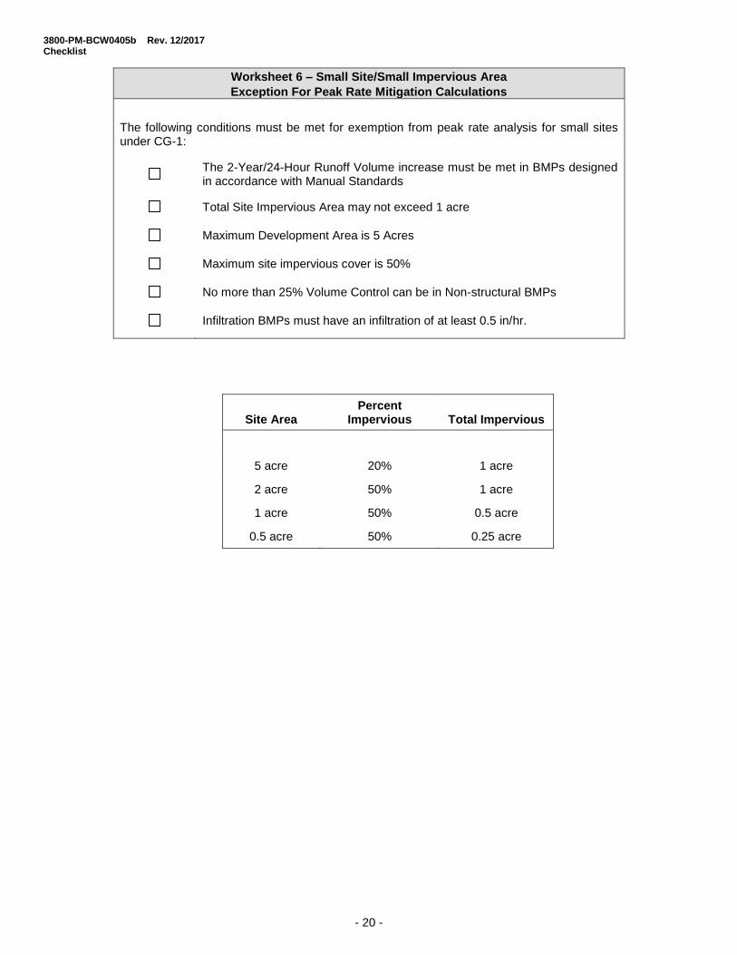
Worksheet 6 – Small Site/Small Impervious Area
Exception For Peak Rate Mitigation Calculations
The following conditions must be met for exemption from peak rate analysis for small sites under CG-1:
The 2-Year/24-Hour Runoff Volume increase must be met in BMPs designed in accordance with Manual Standards
Total Site Impervious Area may not exceed 1 acre
Maximum Development Area is 5 Acres
Maximum site impervious cover is 50%
No more than 25% Volume Control can be in Non-structural BMPs
Infiltration BMPs must have an infiltration of at least 0.5 in/hr.
Site Area Percent
Impervious Total Impervious
5 acre 20% 1 acre
2 acre 50% 1 acre
1 acre 50% 0.5 acre
0.5 acre 50% 0.25 acre
3800-PM-BCW0405b Rev. 12/2017 Checklist
- 21 -
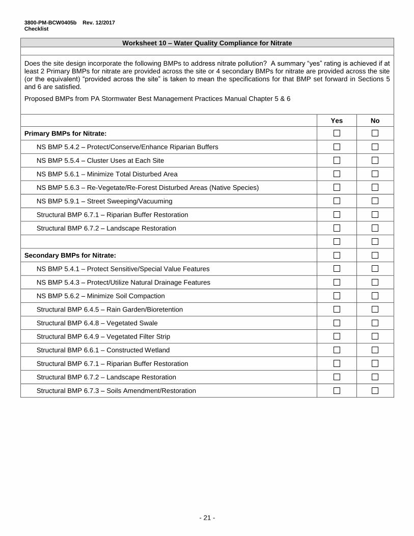
Worksheet 10 – Water Quality Compliance for Nitrate
Does the site design incorporate the following BMPs to address nitrate pollution? A summary “yes” rating is achieved if at least 2 Primary BMPs for nitrate are provided across the site or 4 secondary BMPs for nitrate are provided across the site (or the equivalent) “provided across the site” is taken to mean the specifications for that BMP set forward in Sections 5 and 6 are satisfied.
Proposed BMPs from PA Stormwater Best Management Practices Manual Chapter 5 & 6
Yes No
Primary BMPs for Nitrate:
NS BMP 5.4.2 – Protect/Conserve/Enhance Riparian Buffers
NS BMP 5.5.4 – Cluster Uses at Each Site
NS BMP 5.6.1 – Minimize Total Disturbed Area
NS BMP 5.6.3 – Re-Vegetate/Re-Forest Disturbed Areas (Native Species)
NS BMP 5.9.1 – Street Sweeping/Vacuuming
Structural BMP 6.7.1 – Riparian Buffer Restoration
Structural BMP 6.7.2 – Landscape Restoration
Secondary BMPs for Nitrate:
NS BMP 5.4.1 – Protect Sensitive/Special Value Features
NS BMP 5.4.3 – Protect/Utilize Natural Drainage Features
NS BMP 5.6.2 – Minimize Soil Compaction
Structural BMP 6.4.5 – Rain Garden/Bioretention
Structural BMP 6.4.8 – Vegetated Swale
Structural BMP 6.4.9 – Vegetated Filter Strip
Structural BMP 6.6.1 – Constructed Wetland
Structural BMP 6.7.1 – Riparian Buffer Restoration
Structural BMP 6.7.2 – Landscape Restoration
Structural BMP 6.7.3 – Soils Amendment/Restoration

3800-PM-BCW0405b Rev. 12/2017 Checklist
- 22 -
Worksheet 11 – BMPs for Pollution Prevention
Does the site design incorporate the following BMPs to address nitrate pollution? A summary “yes” rating is achieved if at least 2 Primary BMPs are provided across the site. “Provided across the site” is taken to mean that the specifications for that BMP set forward in Chapters 5 and 6 are satisfied.
Proposed BMPs from PA Stormwater Best Management Practices Manual Chapter 5 & 6
Yes No
BMPs for Pollution Prevention:
NS BMP 5.4.1 – Protect Sensitive/Special Value Features
NS BMP 5.4.2 – Protect/Conserve/Enhance Riparian Buffers
NS BMP 5.4.3 – Protect/Utilize Natural Flow Pathways in Overall Stormwater Planning and Design
NS BMP 5.5.1 – Cluster Uses at Each Site; Build on the Smallest Area Possible
NS BMP 5.6.1 – Minimize Total Disturbed Area - Grading
NS BMP 5.6.2 – Minimize Soil Compaction in Disturbed Areas
NS BMP 5.6.3 – Re-Vegetate/Re-Forest Disturbed Areas (Native Species)
NS BMP 5.7.1 – Reduce Street Imperviousness
NS BMP 5.7.2 – Reduce Parking Imperviousness
NS BMP 5.8.1 – Rooftop Disconnection
NS BMP 5.8.2 – Disconnection from Storm Sewers
NS BMP 5.9.15 – Street Sweeping
Structural BMP 6.7.1 – Riparian Buffer Restoration
Structural BMP 6.7.2 – Landscape Restoration
Structural BMP 6.7.3 – Soils Amendment and Restoration
3800-PM-BCW0405b Rev. 12/2017 Checklist
- 23 -
Worksheet 12 – Water Quality Analysis of Pollutant Loading from All Disturbed Areas
Total Site Area (AC)
Total Disturbed Area (AC)
Disturbed Area Controlled by BMPs (AC)
Total Disturbed Areas:
Pollutant Pollutant Load
Land Cover Classification
TSS EMC (mg/l)
TP EMC (mg/l)
Nitrate- Nitrite EMC (mg/l as N)
Cover (Acres)
Runoff Volume
(AF) TSS** (LBS)
TP** (LBS)
NO3 (LBS)
Forest 39 0.15 0.17
Meadow 47 0.19 0.3
Fertilized Planting Area 55 1.34 0.73
Native Planting Area 55 0.40 0.33
Lawn, Low-Input 180 0.40 0.44
Lawn, High-Input 180 2.22 1.46
Golf Course Fairway/Green 305 1.07 1.84
Grassed Athletic Field 200 1.07 1.01
Rooftop 21 0.13 0.32
High Traffic Street/Highway 261 0.40 0.83
Medium Traffic Street 113 0.33 0.58
Low Traffic/Residential Street 86 0.36 0.47
Res. Driveway, Play Courts, etc. 60 0.46 0.47
High Traffic Parking Lot 120 0.39 0.60
Low Traffic Parking Lot 58 0.15 0.39
TOTAL LOAD
REQUIRED REUCTION (%) 85% 85% 50%
REQUIRED REDUCTION (LBS)
*Pollutant Load = [EMC, mg/l] X [Volume, AF] X [2.7, Unit Conversion]
**TSS and TP calculations only required for projects not meeting CG1/CG2 or not controlling less than 90% of the disturbed area
Pe
rvio
us
Su
rfa
ce
s
Imp
erv
iou
s
Su
rfa
ce
s

3800-PM-BCW0405b Rev. 12/2017 Checklist
- 24 -
Worksheet 13 – Pollutant Reduction Through BMP Applications*
*Fill this worksheet out for each BMP type with different pollutant removal efficiencies. Sum pollutant reduction achieved for all BMP types on final sheet.
BMP Type:
Disturbed Area Controlled by this BMPs (AC)
Disturbed Area Controlled by this BMPs:
Pollutant Pollutant Load**
Land Cover Classification
TSS EMC (mg/l)
TP EMC (mg/l)
Nitrate- Nitrite EMC (mg/l as N)
Cover (Acres)
Runoff Volume
(AF) TSS** (LBS)
TP** (LBS)
NO3 (LBS)
Forest 39 0.15 0.17
Meadow 47 0.19 0.3
Fertilized Planting Area 55 1.34 0.73
Native Planting Area 55 0.40 0.33
Lawn, Low-Input 180 0.40 0.44
Lawn, High-Input 180 2.22 1.46
Golf Course Fairway/Green 305 1.07 1.84
Grassed Athletic Field 200 1.07 1.01
Rooftop 21 0.13 0.32
High Traffic Street/Highway 261 0.40 0.83
Medium Traffic Street 113 0.33 0.58
Low Traffic/Residential Street 86 0.36 0.47
Res. Driveway, Play Courts, etc. 60 0.46 0.47
High Traffic Parking Lot 120 0.39 0.60
Low Traffic Parking Lot 58 0.15 0.39
TOTAL LOAD TO THIS BMP TYPE
POLLUTANT REMOVAL EFFICIENCIES FROM APPENDIX A. STORMWATER MANUAL (%)
POLLUTANT REDUCITON ACHIEVED BY THIS BMP TYPE (LBS)
POLLUTANT REDUCTION ACHIEVED BY ALL BMP TYPES (LBS)
REQUIRED REDUCTION from WS12 (LBS)
*Pollutant Load = [EMC, mg/l] X [Volume, AF] X [2.7, Unit Conversion]
**TSS and TP calculations only required for projects not meeting CG1/CG2 or not controlling less than 90% of the disturbed area
Pe
rvio
us
Su
rfa
ce
s
Imp
erv
iou
s
Su
rfa
ce
s

3800-PM-BCW0405b Rev. 12/2017 Checklist
- 25 -
Worksheet 14 – Water Quality Analysis of Pollutant Loading from Disturbance in Buffer Area
Total Disturbed Area (AC)
Disturbed Area Controlled by this BMPs (AC)
Existing Condition
Pollutant Pollutant Load
Land Cover Classification
TSS EMC (mg/l)
TP EMC (mg/l)
Nitrate- Nitrite EMC (mg/l as N)
Cover (Acres)
Runoff Volume
(AF) TSS** (LBS)
TP** (LBS)
NO3 (LBS)
Forest 39 0.15 0.17
Meadow 47 0.19 0.3
TOTAL LOAD
Post-Development
Pollutant Pollutant Load
Land Cover Classification
TSS EMC (mg/l)
TP EMC (mg/l)
Nitrate- Nitrite EMC (mg/l as N)
Cover (Acres)
Runoff Volume
(AF) TSS** (LBS)
TP** (LBS)
NO3 (LBS)
Forest 39 0.15 0.17
Meadow 47 0.19 0.3
Fertilized Planting Area 55 1.34 0.73
Native Planting Area 55 0.40 0.33
Lawn, Low-Input 180 0.40 0.44
Lawn, High-Input 180 2.22 1.46
Golf Course Fairway/Green 305 1.07 1.84
Grassed Athletic Field 200 1.07 1.01
Rooftop 21 0.13 0.32
High Traffic Street/Highway 261 0.40 0.83
Medium Traffic Street 113 0.33 0.58
Low Traffic/Residential Street 86 0.36 0.47
Res. Driveway, Play Courts, etc. 60 0.46 0.47
High Traffic Parking Lot 120 0.39 0.60
Low Traffic Parking Lot 58 0.15 0.39
TOTAL LOAD
Pollutant Load increase (LBS) =
Pollutant Load increase (LBS) = Post development load – Pre-development load
*Pollutant Load = [EMC, mg/l] X [Volume, AF] X [2.7, Unit Conversion
Pe
rvio
us
Su
rfa
ce
s
Imp
erv
iou
s
Su
rfa
ce
s

3800-PM-BCW0405b Rev. 12/2017 Checklist
- 26 -
Worksheet 15 – Pollutant Reduction Through BMP Applications*
*Fill this worksheet out for each BMP type with different pollutant removal efficiencies. Sum pollutant reduction achieved for all BMP types on final sheet.
BMP Type: Disturbed Area Controlled by this BMPs:
Pollutant Pollutant Load**
Land Cover Classification
TSS EMC (mg/l)
TP EMC (mg/l)
Nitrate- Nitrite EMC (mg/l as N)
Cover (Acres)
Runoff Volume
(AF) TSS** (LBS)
TP** (LBS)
NO3 (LBS)
Forest 39 0.15 0.17
Meadow 47 0.19 0.3
Fertilized Planting Area 55 1.34 0.73
Native Planting Area 55 0.40 0.33
Lawn, Low-Input 180 0.40 0.44
Lawn, High-Input 180 2.22 1.46
Golf Course Fairway/Green 305 1.07 1.84
Grassed Athletic Field 200 1.07 1.01
Rooftop 21 0.13 0.32
High Traffic Street/Highway 261 0.40 0.83
Medium Traffic Street 113 0.33 0.58
Low Traffic/Residential Street 86 0.36 0.47
Res. Driveway, Play Courts, etc. 60 0.46 0.47
High Traffic Parking Lot 120 0.39 0.60
Low Traffic Parking Lot 58 0.15 0.39
TOTAL LOAD TO THIS BMP TYPE
POLLUTANT REMOVAL EFFICIENCIES FROM APPENDIX A. STORMWATER MANUAL (%)
POLLUTANT REDUCTION ACHIEVED BY THIS BMP TYPE (LBS)
POLLUTANT REDUCTION ACHIEVED BY ALL BMP TYPES (LBS)
REQUIRED REDUCTION from WS 14 (LBS)
*Pollutant Load = [EMC, mg/l] X [Volume, AF] X [2.7, Unit Conversion]
Pe
rvio
us
Su
rfa
ce
s
Imp
erv
iou
s
Su
rfa
ce
s

3800-PM-BCW0405b Rev. 11/2017 Checklist
- 27 -
Checklist for Functional Equivalency of Riparian Buffers and Riparian Forest Buffers
Riparian Buffer Riparian Forest Buffer
Filtration of pollutants in runoff
Infiltration and maintenance of streamflow
Water quality maintenance
Habitat for wildlife and vegetation
Flood attenuation
Light control and water temperature moderation
Travel corridors for migration and dispersal
Ice damage control
Stream width
Food supply
Wood debris input
Support of aquatic food chains and webs as they relate to terrestrial food webs
Channel and shoreline stability/decrease in erosion
Reduced effects of storm events
Instream pollutant processing