Embed Size (px)
Citation preview
NPDES Storm Water Management Plan Annual Report – Permit Year 7
Page 2
Part II. Self-Assessment MassDOT – Highway Division has completed the required self-assessment and continues to determine that the MS4 is in full compliance with the permit conditions. On April 2, 2007, MassDOT received full authorization to discharge stormwater from MassDOT owned and operated MS4s in urbanized areas of Massachusetts. EPA requested that MassDOT continue to update/revise the SWMP in a letter dated August 18, 2006 and October 10, 2006. MassDOT submitted a revised SWMP to address the EPA comments on January 11, 2008. MassDOT has not received any further comments from EPA regarding the revised SWMP submission. NOTE: Massachusetts Highway Department (“MassHighway”) was integrated into the new Massachusetts Department of Transportation, Division of Highways, effective November 1, 2009, pursuant to St. 2009, c. 25, § 8. The activities outlined in this annual report relate only to former MassHighway roads, and not to all MassDOT roads. The new Massachusetts Department of Transportation, Division of Highways will hereinafter be referred to as “MassDOT.” For the next permit year (2010-2011), MassDOT will submit a consolidated annual report incorporating the programs and accomplishments of what was formerly known as MassHighway, the MassTurnpike Authority, and some additional former MA Department of Conservation and Recreation roads.
NPDES Storm Water Management Plan Annual Report – Permit Year 7
Page 3
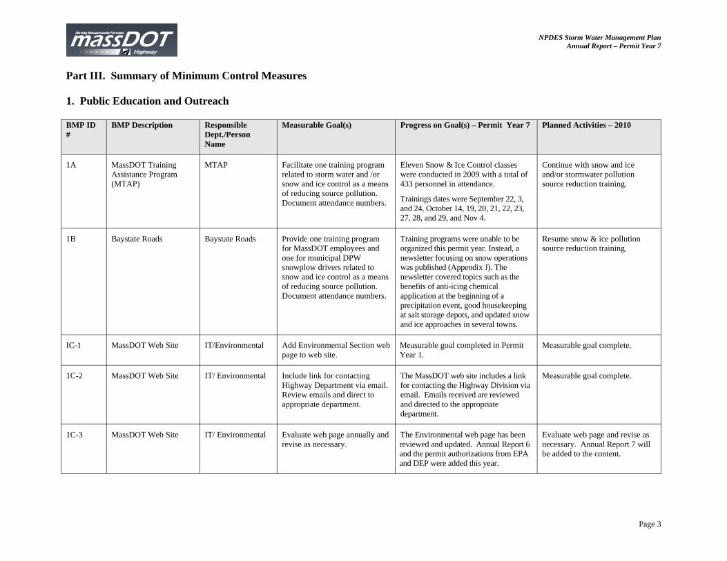
Part III. Summary of Minimum Control Measures 1. Public Education and Outreach BMP ID #
BMP Description Responsible Dept./Person Name
Measurable Goal(s) Progress on Goal(s) – Permit Year 7 Planned Activities – 2010
1A MassDOT Training Assistance Program (MTAP)
MTAP Facilitate one training program related to storm water and /or snow and ice control as a means of reducing source pollution. Document attendance numbers.
Eleven Snow & Ice Control classes were conducted in 2009 with a total of 433 personnel in attendance.
Trainings dates were September 22, 3, and 24, October 14, 19, 20, 21, 22, 23, 27, 28, and 29, and Nov 4.
Continue with snow and ice and/or stormwater pollution source reduction training.
1B Baystate Roads Baystate Roads Provide one training program for MassDOT employees and one for municipal DPW snowplow drivers related to snow and ice control as a means of reducing source pollution. Document attendance numbers.
Training programs were unable to be organized this permit year. Instead, a newsletter focusing on snow operations was published (Appendix J). The newsletter covered topics such as the benefits of anti-icing chemical application at the beginning of a precipitation event, good housekeeping at salt storage depots, and updated snow and ice approaches in several towns.
Resume snow & ice pollution source reduction training.
IC-1 MassDOT Web Site IT/Environmental Add Environmental Section web page to web site.
Measurable goal completed in Permit Year 1.
Measurable goal complete.
1C-2 MassDOT Web Site IT/ Environmental Include link for contacting Highway Department via email. Review emails and direct to appropriate department.
The MassDOT web site includes a link for contacting the Highway Division via email. Emails received are reviewed and directed to the appropriate department.
Measurable goal complete.
1C-3 MassDOT Web Site IT/ Environmental Evaluate web page annually and revise as necessary.
The Environmental web page has been reviewed and updated. Annual Report 6 and the permit authorizations from EPA and DEP were added this year.
Evaluate web page and revise as necessary. Annual Report 7 will be added to the content.
NPDES Storm Water Management Plan Annual Report – Permit Year 7
Page 4
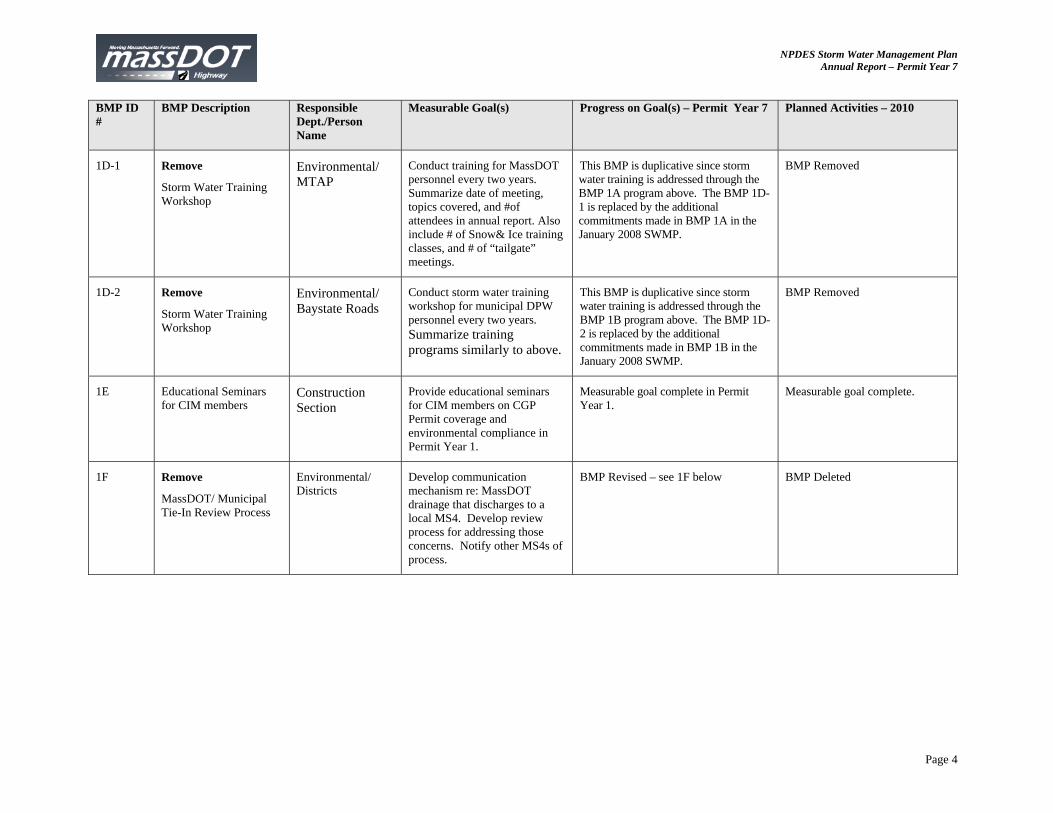
BMP ID #
BMP Description Responsible Dept./Person Name
Measurable Goal(s) Progress on Goal(s) – Permit Year 7 Planned Activities – 2010
1D-1 Remove
Storm Water Training Workshop
Environmental/ MTAP
Conduct training for MassDOT personnel every two years. Summarize date of meeting, topics covered, and #of attendees in annual report. Also include # of Snow& Ice training classes, and # of “tailgate” meetings.
This BMP is duplicative since storm water training is addressed through the BMP 1A program above. The BMP 1D-1 is replaced by the additional commitments made in BMP 1A in the January 2008 SWMP.
BMP Removed
1D-2 Remove
Storm Water Training Workshop
Environmental/ Baystate Roads
Conduct storm water training workshop for municipal DPW personnel every two years. Summarize training programs similarly to above.
This BMP is duplicative since storm water training is addressed through the BMP 1B program above. The BMP 1D-2 is replaced by the additional commitments made in BMP 1B in the January 2008 SWMP.
BMP Removed
1E Educational Seminars for CIM members
Construction Section
Provide educational seminars for CIM members on CGP Permit coverage and environmental compliance in Permit Year 1.
Measurable goal complete in Permit Year 1.
Measurable goal complete.
1F Remove
MassDOT/ Municipal Tie-In Review Process
Environmental/ Districts
Develop communication mechanism re: MassDOT drainage that discharges to a local MS4. Develop review process for addressing those concerns. Notify other MS4s of process.
BMP Revised – see 1F below BMP Deleted
NPDES Storm Water Management Plan Annual Report – Permit Year 7
Page 5
BMP ID #
BMP Description Responsible Dept./Person Name
Measurable Goal(s) Progress on Goal(s) – Permit Year 7 Planned Activities – 2010
1F Revised (Revised in Jan 08 SWMP)
Post Contact Names for Municipal Drainage Concerns on MassDOT Web Site
Environmental/ Districts/ GIS
1) Distribute a flyer with contact names to municipalities during May 2007 Baystate Roads NPDES Phase II General Permit seminar.
2) Post DHD contact name for each district on website for municipalities to contact and maintain link.
3) GIS group will develop a program to provide easy to use access and allow the public to identify a selected area and review the MassDOT owned roads and outfalls. MassDOT will then review alternatives for alerting towns and the public to the availability of this information.
1) Completed in Year 5.
2) DHD contact names continue to be updated on the web site. Go to http://www.mhd.state. ma.us/highway and click on “Find Project Information”
3) MassDOT shared drainage outfall inventory information with Shrewsbury and DCR, as requested.
1) Completed in Year 5.
2) Continue to maintain contact names.
3) Share drainage inventory information as requested.
1G River and Stream Signs Traffic Operations Maintain signs identifying rivers and streams crossed by MassDOT roads, until crossing of all named rivers and streams are signposted.
MassDOT has installed 16 signs identifying river and stream crossings in Permit Year 7. The locations were identified by MassRiverways Program and installed by MassDOT personnel. A list of the locations is included in Appendix A of this report.
MassDOT will continue to install signs in areas identified by MassRiverways Program and anticipates installing approximately 15-20 signs in the next 6 months.
1H Anti-litter/ Dumping Messages on Variable Message Boards
Operations Maintain anti-litter message in the message mix on permanent Variable Message Boards (VMBs).
Anti-litter messages were included in the message mix on permanent Variable Message Boards.
Continue to include anti-litter messages on VMBs.
1I Anti-litter/ Dumping Literature at Visitors Centers
Operations Work with EOEEA’s Think Blue Campaign to identify appropriate brochures for use in Visitor’s Centers. Distribute literature to appropriate visitor centers and track number of brochures distributed annually.
The literature is still in the development process. The Think Blue Campaign will not be utilized for this BMP due to lack of resources and agreement for approach to project.
MassDOT will work with its consultants to develop a new approach. Coordination has begun with AECOM regarding the development of literature.
NPDES Storm Water Management Plan Annual Report – Permit Year 7
Page 6
BMP ID #
BMP Description Responsible Dept./Person Name
Measurable Goal(s) Progress on Goal(s) – Permit Year 7 Planned Activities – 2010
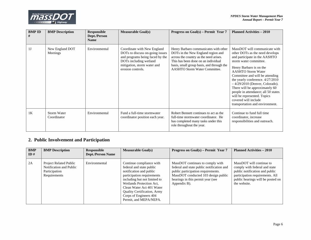
1J New England DOT Meetings
Environmental Coordinate with New England DOTs to discuss on-going issues and programs being faced by the DOTs including wetland mitigation, storm water and erosion controls.
Henry Barbaro communicates with other DOTs in the New England region and across the country as the need arises. This has been done on an individual basis, small group basis, and through the AASHTO Storm Water Committee.
MassDOT will communicate with other DOTs as the need develops and participate in the AASHTO storm water committee.
Henry Barbaro is on the AASHTO Storm Water Committee and will be attending the yearly conference. 4/27/2010 – 4/29/2010 (Denver, Colorado). There will be approximately 60 people in attendance; all 50 states will be represented. Topics covered will include transportation and environment.
1K Storm Water Coordinator
Environmental Fund a full-time stormwater coordinator position each year.
Robert Bennett continues to act as the full-time stormwater coordinator. He has completed many tasks under this role throughout the year.
Continue to fund full time coordinator, increase responsibilities and outreach.
2. Public Involvement and Participation BMP ID #
BMP Description Responsible Dept./Person Name
Measurable Goal(s) Progress on Goal(s) – Permit Year 7 Planned Activities – 2010
2A Project Related Public Notification and Public Participation Requirements
Environmental Continue compliance with federal and state public notification and public participation requirements including but not limited to Wetlands Protection Act, Clean Water Act 401 Water Quality Certification, Army Corps of Engineers 404 Permit, and MEPA/NEPA.
MassDOT continues to comply with federal and state public notification and public participation requirements. MassDOT conducted 103 design public hearings in this permit year (see Appendix B).
MassDOT will continue to comply with federal and state public notification and public participation requirements. All public hearings will be posted on the website.
NPDES Storm Water Management Plan Annual Report – Permit Year 7
Page 7
BMP ID #
BMP Description Responsible Dept./Person Name
Measurable Goal(s) Progress on Goal(s) – Permit Year 7 Planned Activities – 2010
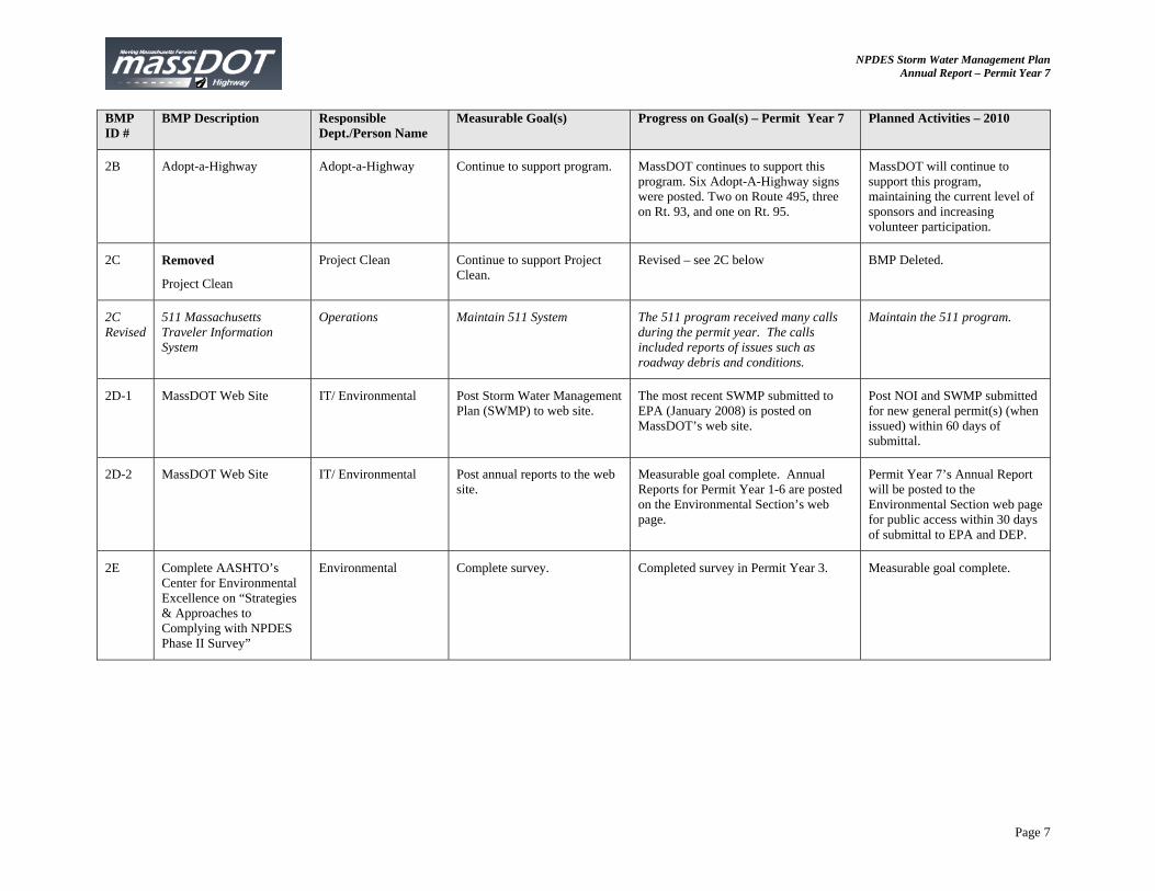
2B Adopt-a-Highway Adopt-a-Highway Continue to support program. MassDOT continues to support this program. Six Adopt-A-Highway signs were posted. Two on Route 495, three on Rt. 93, and one on Rt. 95.
MassDOT will continue to support this program, maintaining the current level of sponsors and increasing volunteer participation.
2C Removed
Project Clean
Project Clean Continue to support Project Clean.
Revised – see 2C below BMP Deleted.
2C Revised
511 Massachusetts Traveler Information System
Operations Maintain 511 System The 511 program received many calls during the permit year. The calls included reports of issues such as roadway debris and conditions.
Maintain the 511 program.
2D-1 MassDOT Web Site IT/ Environmental Post Storm Water Management Plan (SWMP) to web site.
The most recent SWMP submitted to EPA (January 2008) is posted on MassDOT’s web site.
Post NOI and SWMP submitted for new general permit(s) (when issued) within 60 days of submittal.
2D-2 MassDOT Web Site IT/ Environmental Post annual reports to the web site.
Measurable goal complete. Annual Reports for Permit Year 1-6 are posted on the Environmental Section’s web page.
Permit Year 7’s Annual Report will be posted to the Environmental Section web page for public access within 30 days of submittal to EPA and DEP.
2E Complete AASHTO’s Center for Environmental Excellence on “Strategies & Approaches to Complying with NPDES Phase II Survey”
Environmental Complete survey. Completed survey in Permit Year 3.
Measurable goal complete.
NPDES Storm Water Management Plan Annual Report – Permit Year 7
Page 8
3. Illicit Discharge Detection and Elimination BMP ID #
BMP Description Responsible Dept./Person Name
Measurable Goal(s) Progress on Goal(s) – Permit Year 7
Planned Activities – 2010
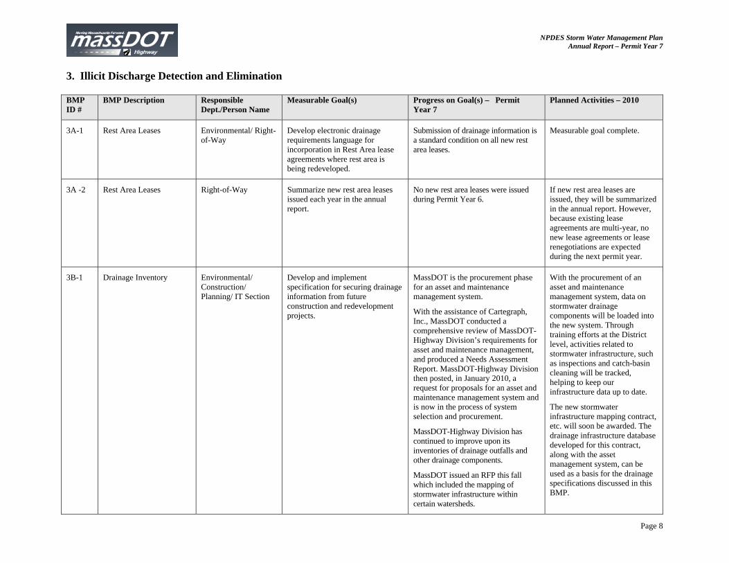
3A-1 Rest Area Leases Environmental/ Right-of-Way
Develop electronic drainage requirements language for incorporation in Rest Area lease agreements where rest area is being redeveloped.
Submission of drainage information is a standard condition on all new rest area leases.
Measurable goal complete.
3A -2 Rest Area Leases Right-of-Way Summarize new rest area leases issued each year in the annual report.
No new rest area leases were issued during Permit Year 6.
If new rest area leases are issued, they will be summarized in the annual report. However, because existing lease agreements are multi-year, no new lease agreements or lease renegotiations are expected during the next permit year.
3B-1 Drainage Inventory Environmental/ Construction/ Planning/ IT Section
Develop and implement specification for securing drainage information from future construction and redevelopment projects.
MassDOT is the procurement phase for an asset and maintenance management system.
With the assistance of Cartegraph, Inc., MassDOT conducted a comprehensive review of MassDOT-Highway Division’s requirements for asset and maintenance management, and produced a Needs Assessment Report. MassDOT-Highway Division then posted, in January 2010, a request for proposals for an asset and maintenance management system and is now in the process of system selection and procurement.
MassDOT-Highway Division has continued to improve upon its inventories of drainage outfalls and other drainage components.
MassDOT issued an RFP this fall which included the mapping of stormwater infrastructure within certain watersheds.
With the procurement of an asset and maintenance management system, data on stormwater drainage components will be loaded into the new system. Through training efforts at the District level, activities related to stormwater infrastructure, such as inspections and catch-basin cleaning will be tracked, helping to keep our infrastructure data up to date.
The new stormwater infrastructure mapping contract, etc. will soon be awarded. The drainage infrastructure database developed for this contract, along with the asset management system, can be used as a basis for the drainage specifications discussed in this BMP.
NPDES Storm Water Management Plan Annual Report – Permit Year 7
Page 9
BMP ID #
BMP Description Responsible Dept./Person Name
Measurable Goal(s) Progress on Goal(s) – Permit Year 7
Planned Activities – 2010
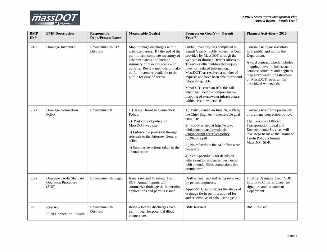
3B-2 Drainage Inventory Environmental/ IT/ Districts
Map drainage discharges within urbanized areas. By the end of the permit term complete inventory of urbanized areas and include summary of resource areas with outfalls. Review methods to make outfall inventory available to the public for ease of access.
Outfall inventory was completed in Permit Year 5. Public access has been provided by MassDOT through the web site or through District offices to Town’s or other entities that request inventory related information. MassDOT has received a number of requests and have been able to respond relatively quickly.
MassDOT issued an RFP this fall which included the comprehensive mapping of stormwater infrastructure within certain watersheds.
Continue to share inventory with public and within the Department.
Award contract which includes mapping, develop infrastructure database structure and begin to map stormwater infrastructure on MassDOT roads within prioritized watersheds.
3C-1 Drainage Connection Policy
Environmental 1.) Issue Drainage Connection Policy.
2) Post copy of policy on MassDOT web site.
3) Enforce the provision through referrals to the Attorney General office.
4) Summarize actions taken in the annual report.
1.) Policy issued on June 26, 2006 by the Chief Engineer – measurable goal complete.
2.) Policy posted at http://www. mhd.state.ma.us/downloads /engineeringDirectives/policy /p_96_002.pdf
3.) No referrals to the AG office were necessary.
4) See Appendix D for details on letters sent to residences/ businesses with potential illicit connections this permit term.
Continue to enforce provisions of drainage connection policy.
The Executive Office of Transportation Legal and Environmental Services will take steps to make the Drainage Tie-In Policy a formal MassDOT SOP.
3C-2 Drainage Tie-In Standard Operation Procedure (SOP)
Environmental/ Legal Issue a revised Drainage Tie-In SOP. Annual reports will summarize drainage tie-in permits applications and permits issued.
Draft is finalized and being reviewed by permit engineers.
Appendix C summarizes the status of drainage tie-in permits applied for and received as of this permit year.
Finalize Drainage Tie-In SOP. Submit to Chief Engineer for signature and issuance to Department.
3D Revised
Illicit Connection Review
Environmental/ Districts
Review twenty discharges each permit year for potential illicit connections.
BMP Revised BMP Revised
NPDES Storm Water Management Plan Annual Report – Permit Year 7
Page 10
BMP ID #
BMP Description Responsible Dept./Person Name
Measurable Goal(s) Progress on Goal(s) – Permit Year 7
Planned Activities – 2010
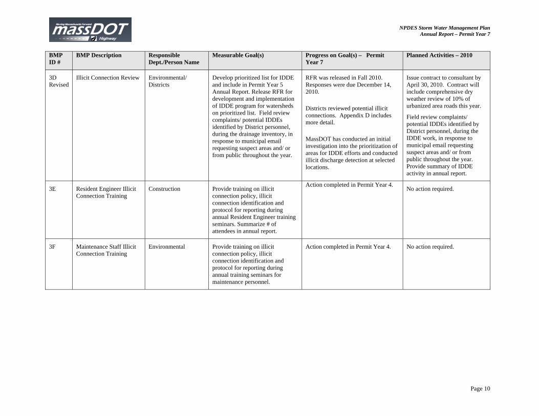
3D Revised
Illicit Connection Review Environmental/ Districts
Develop prioritized list for IDDE and include in Permit Year 5 Annual Report. Release RFR for development and implementation of IDDE program for watersheds on prioritized list. Field review complaints/ potential IDDEs identified by District personnel, during the drainage inventory, in response to municipal email requesting suspect areas and/ or from public throughout the year.
RFR was released in Fall 2010. Responses were due December 14, 2010.
Districts reviewed potential illicit connections. Appendix D includes more detail.
MassDOT has conducted an initial investigation into the prioritization of areas for IDDE efforts and conducted illicit discharge detection at selected locations.
Issue contract to consultant by April 30, 2010. Contract will include comprehensive dry weather review of 10% of urbanized area roads this year.
Field review complaints/ potential IDDEs identified by District personnel, during the IDDE work, in response to municipal email requesting suspect areas and/ or from public throughout the year. Provide summary of IDDE activity in annual report.
3E Resident Engineer Illicit Connection Training
Construction Provide training on illicit connection policy, illicit connection identification and protocol for reporting during annual Resident Engineer training seminars. Summarize # of attendees in annual report.
Action completed in Permit Year 4. No action required.
3F Maintenance Staff Illicit Connection Training
Environmental Provide training on illicit connection policy, illicit connection identification and protocol for reporting during annual training seminars for maintenance personnel.
Action completed in Permit Year 4. No action required.
NPDES Storm Water Management Plan Annual Report – Permit Year 7
Page 11
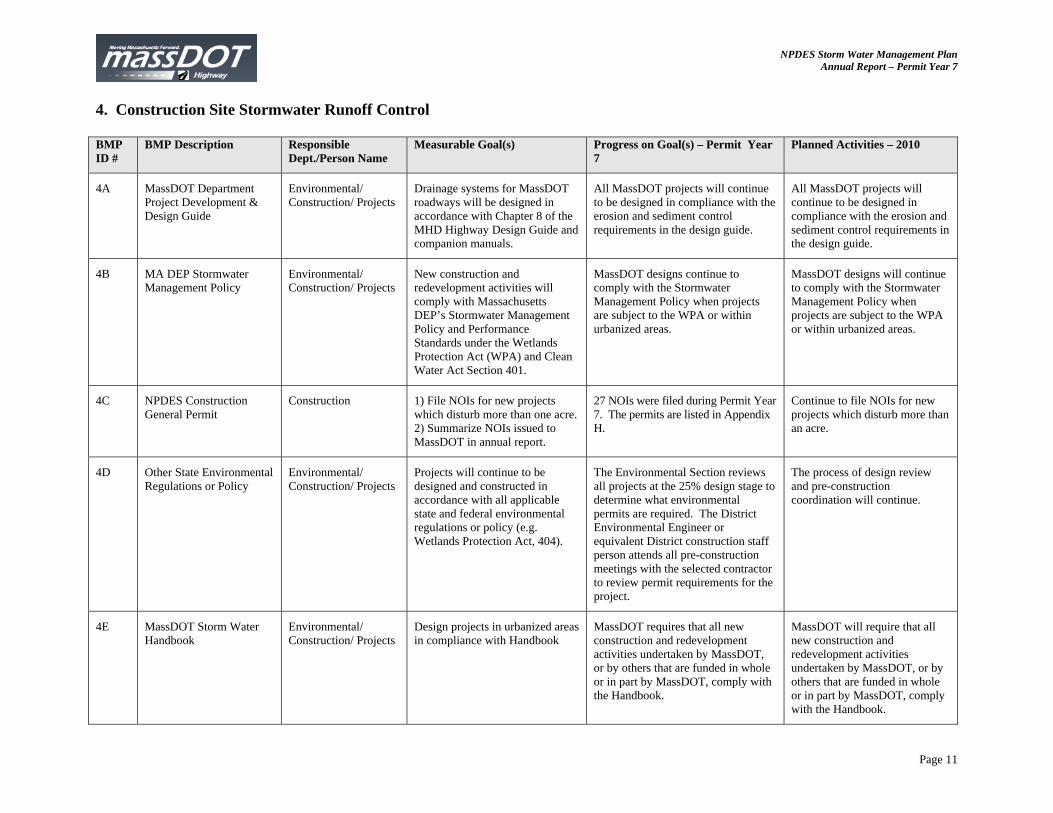
4. Construction Site Stormwater Runoff Control BMP ID #
BMP Description Responsible Dept./Person Name
Measurable Goal(s) Progress on Goal(s) – Permit Year 7
Planned Activities – 2010
4A MassDOT Department Project Development & Design Guide
Environmental/ Construction/ Projects
Drainage systems for MassDOT roadways will be designed in accordance with Chapter 8 of the MHD Highway Design Guide and companion manuals.
All MassDOT projects will continue to be designed in compliance with the erosion and sediment control requirements in the design guide.
All MassDOT projects will continue to be designed in compliance with the erosion and sediment control requirements in the design guide.
4B MA DEP Stormwater Management Policy
Environmental/ Construction/ Projects
New construction and redevelopment activities will comply with Massachusetts DEP’s Stormwater Management Policy and Performance Standards under the Wetlands Protection Act (WPA) and Clean Water Act Section 401.
MassDOT designs continue to comply with the Stormwater Management Policy when projects are subject to the WPA or within urbanized areas.
MassDOT designs will continue to comply with the Stormwater Management Policy when projects are subject to the WPA or within urbanized areas.
4C NPDES Construction General Permit
Construction 1) File NOIs for new projects which disturb more than one acre. 2) Summarize NOIs issued to MassDOT in annual report.
27 NOIs were filed during Permit Year 7. The permits are listed in Appendix H.
Continue to file NOIs for new projects which disturb more than an acre.
4D Other State Environmental Regulations or Policy
Environmental/ Construction/ Projects
Projects will continue to be designed and constructed in accordance with all applicable state and federal environmental regulations or policy (e.g. Wetlands Protection Act, 404).
The Environmental Section reviews all projects at the 25% design stage to determine what environmental permits are required. The District Environmental Engineer or equivalent District construction staff person attends all pre-construction meetings with the selected contractor to review permit requirements for the project.
The process of design review and pre-construction coordination will continue.
4E MassDOT Storm Water Handbook
Environmental/ Construction/ Projects
Design projects in urbanized areas in compliance with Handbook
MassDOT requires that all new construction and redevelopment activities undertaken by MassDOT, or by others that are funded in whole or in part by MassDOT, comply with the Handbook.
MassDOT will require that all new construction and redevelopment activities undertaken by MassDOT, or by others that are funded in whole or in part by MassDOT, comply with the Handbook.
NPDES Storm Water Management Plan Annual Report – Permit Year 7
Page 12
BMP ID #
BMP Description Responsible Dept./Person Name
Measurable Goal(s) Progress on Goal(s) – Permit Year 7
Planned Activities – 2010
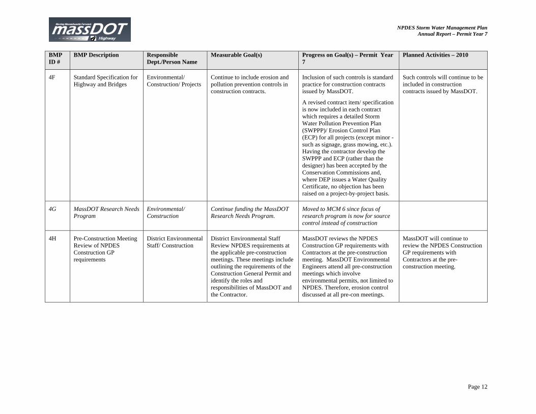
4F Standard Specification for Highway and Bridges
Environmental/ Construction/ Projects
Continue to include erosion and pollution prevention controls in construction contracts.
Inclusion of such controls is standard practice for construction contracts issued by MassDOT.
A revised contract item/ specification is now included in each contract which requires a detailed Storm Water Pollution Prevention Plan (SWPPP)/ Erosion Control Plan (ECP) for all projects (except minor - such as signage, grass mowing, etc.). Having the contractor develop the SWPPP and ECP (rather than the designer) has been accepted by the Conservation Commissions and, where DEP issues a Water Quality Certificate, no objection has been raised on a project-by-project basis.
Such controls will continue to be included in construction contracts issued by MassDOT.
4G MassDOT Research Needs Program
Environmental/ Construction
Continue funding the MassDOT Research Needs Program.
Moved to MCM 6 since focus of research program is now for source control instead of construction
4H Pre-Construction Meeting Review of NPDES Construction GP requirements
District Environmental Staff/ Construction
District Environmental Staff Review NPDES requirements at the applicable pre-construction meetings. These meetings include outlining the requirements of the Construction General Permit and identify the roles and responsibilities of MassDOT and the Contractor.
MassDOT reviews the NPDES Construction GP requirements with Contractors at the pre-construction meeting. MassDOT Environmental Engineers attend all pre-construction meetings which involve environmental permits, not limited to NPDES. Therefore, erosion control discussed at all pre-con meetings.
MassDOT will continue to review the NPDES Construction GP requirements with Contractors at the pre-construction meeting.
NPDES Storm Water Management Plan Annual Report – Permit Year 7
Page 13
BMP ID #
BMP Description Responsible Dept./Person Name
Measurable Goal(s) Progress on Goal(s) – Permit Year 7
Planned Activities – 2010
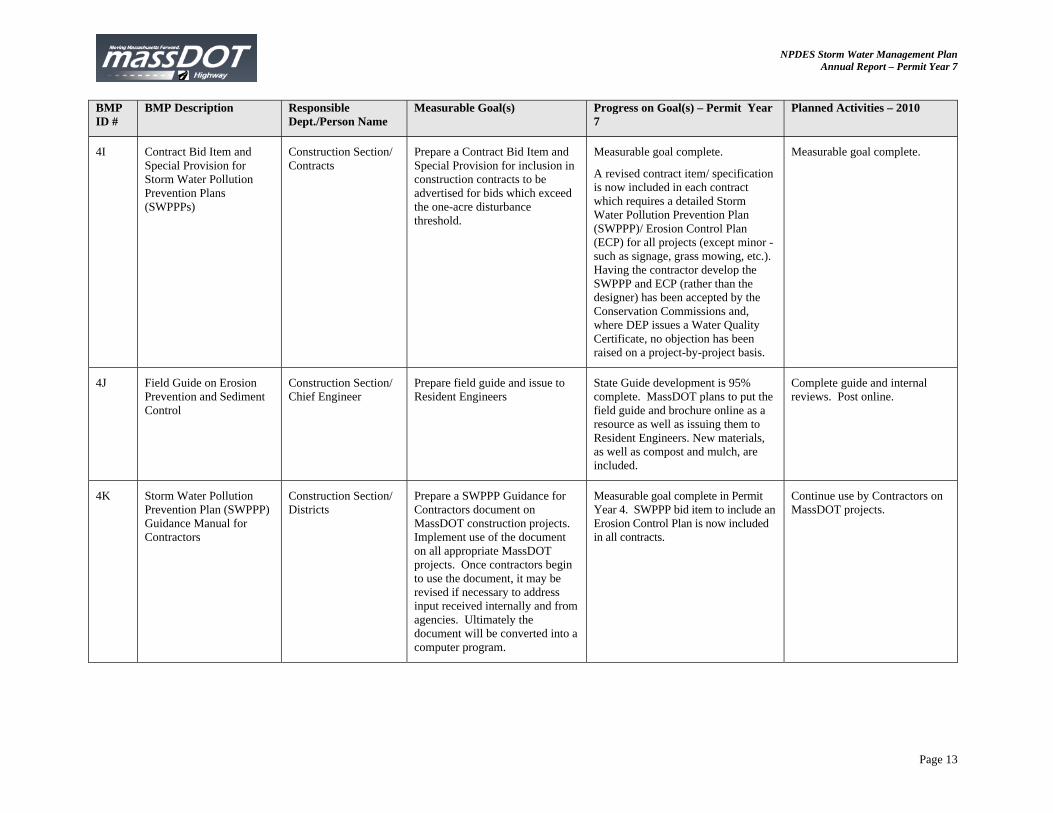
4I Contract Bid Item and Special Provision for Storm Water Pollution Prevention Plans (SWPPPs)
Construction Section/ Contracts
Prepare a Contract Bid Item and Special Provision for inclusion in construction contracts to be advertised for bids which exceed the one-acre disturbance threshold.
Measurable goal complete.
A revised contract item/ specification is now included in each contract which requires a detailed Storm Water Pollution Prevention Plan (SWPPP)/ Erosion Control Plan (ECP) for all projects (except minor - such as signage, grass mowing, etc.). Having the contractor develop the SWPPP and ECP (rather than the designer) has been accepted by the Conservation Commissions and, where DEP issues a Water Quality Certificate, no objection has been raised on a project-by-project basis.
Measurable goal complete.
4J Field Guide on Erosion Prevention and Sediment Control
Construction Section/ Chief Engineer
Prepare field guide and issue to Resident Engineers
State Guide development is 95% complete. MassDOT plans to put the field guide and brochure online as a resource as well as issuing them to Resident Engineers. New materials, as well as compost and mulch, are included.
Complete guide and internal reviews. Post online.
4K Storm Water Pollution Prevention Plan (SWPPP) Guidance Manual for Contractors
Construction Section/ Districts
Prepare a SWPPP Guidance for Contractors document on MassDOT construction projects. Implement use of the document on all appropriate MassDOT projects. Once contractors begin to use the document, it may be revised if necessary to address input received internally and from agencies. Ultimately the document will be converted into a computer program.
Measurable goal complete in Permit Year 4. SWPPP bid item to include an Erosion Control Plan is now included in all contracts.
Continue use by Contractors on MassDOT projects.
NPDES Storm Water Management Plan Annual Report – Permit Year 7
Page 14
BMP ID #
BMP Description Responsible Dept./Person Name
Measurable Goal(s) Progress on Goal(s) – Permit Year 7
Planned Activities – 2010
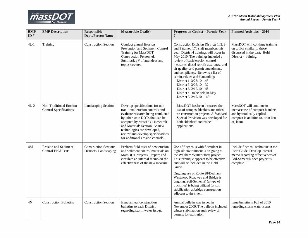
4L-1 Training Construction Section Conduct annual Erosion Prevention and Sediment Control Training for MassDOT Construction Personnel. Summarize # of attendees and topics covered.
Construction Division Districts 1, 2, 3, and 5 trained 170 staff members this year. District 4 trainings will occur in May 2010. The trainings included a review of basic erosion control measures, diesel retrofit awareness and air quality, and permit amendments and compliance. Below is a list of seminar dates and # attending:
District 1 3/23/10 48 District 3 3/05/10 32 District 3 2/12/10 45 District 4 to be held in May District 5 2/12/10 45
MassDOT will continue training on topics similar to those discussed in the past. Hold District 4 training.
4L-2 Non-Traditional Erosion Control Specifications
Landscaping Section Develop specifications for non-traditional erosion controls and evaluate research being conducted by other state DOTs that can be accepted by MassDOT Research and Materials Section. As new technologies are developed, review and develop specifications for additional erosion controls.
MassDOT has been increased the use of compost blankets and tubes on construction projects. A Standard Special Provision was developed for both “blanket” and “tube” applications.
MassDOT will continue to increase use of compost blankets and hydraulically applied compost in addition to, or in lieu of, loam.
4M Erosion and Sediment Control Field Tests
Construction Section/ Districts/ Landscaping
Perform field tests of new erosion and sediment control materials on MassDOT projects. Prepare and circulate an internal memo on the effectiveness of the new measure.
Use of fiber rolls with flocculent in high silt environment is on-going at the Waltham Winter Street project. This technique appears to be effective and will be included in the Field Guide.
Ongoing use of Route 28/Dedham Westwood Roadway and Bridge is ongoing. Soil-Sement® (a type of trackifier) is being utilized for soil stabilization at bridge construction adjacent to the river.
Include fiber roll technique in the Field Guide. Develop internal memo regarding effectiveness of Soil-Sement® once project is complete.
4N Construction Bulletins Construction Section Issue annual construction bulletins to each District regarding storm water issues.
Annual bulletin was issued in November 2009. The bulletin included winter stabilization and review of permits for expiration.
Issue bulletin in Fall of 2010 regarding storm water issues.
NPDES Storm Water Management Plan Annual Report – Permit Year 7
Page 15
BMP ID #
BMP Description Responsible Dept./Person Name
Measurable Goal(s) Progress on Goal(s) – Permit Year 7
Planned Activities – 2010
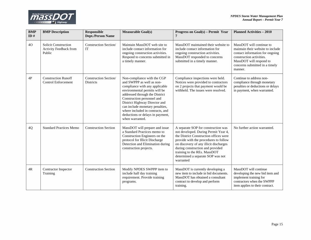
4O Solicit Construction Activity Feedback from Public
Construction Section/ IT
Maintain MassDOT web site to include contact information for ongoing construction activities. Respond to concerns submitted in a timely manner.
MassDOT maintained their website to include contact information for ongoing construction activities. MassDOT responded to concerns submitted in a timely manner.
MassDOT will continue to maintain their website to include contact information for ongoing construction activities. MassDOT will respond to concerns submitted in a timely manner.
4P Construction Runoff Control Enforcement
Construction Section/ Districts
Non-compliance with the CGP and SWPPP as well as non-compliance with any applicable environmental permits will be addressed through the District Construction personnel and District Highway Director and can include monetary penalties, where included in contracts, and deductions or delays in payment, when warranted.
Compliance inspections were held. Notices were provided to contractors on 2 projects that payment would be withheld. The issues were resolved.
Continue to address non-compliance through monetary penalties or deductions or delays in payment, when warranted.
4Q Standard Practices Memo Construction Section MassDOT will prepare and issue a Standard Practices memo to Construction Engineers on the protocol for Illicit Discharge Detection and Elimination during construction projects.
A separate SOP for construction was not developed. During Permit Year 4, the District Construction offices were provide with the procedures to follow on discovery of any illicit discharges during construction and provided training to the REs. MassDOT determined a separate SOP was not warranted
No further action warranted.
4R Contractor Inspector Training
Construction Section Modify NPDES SWPPP item to include half day training requirement. Provide training programs.
MassDOT is currently developing a new item to include in bid documents. MassDOT has obtained a consultant contract to develop and perform training.
MassDOT will continue developing the new bid item and implement training for contractors when the SWPPP item applies to their contract.
NPDES Storm Water Management Plan Annual Report – Permit Year 7
Page 16
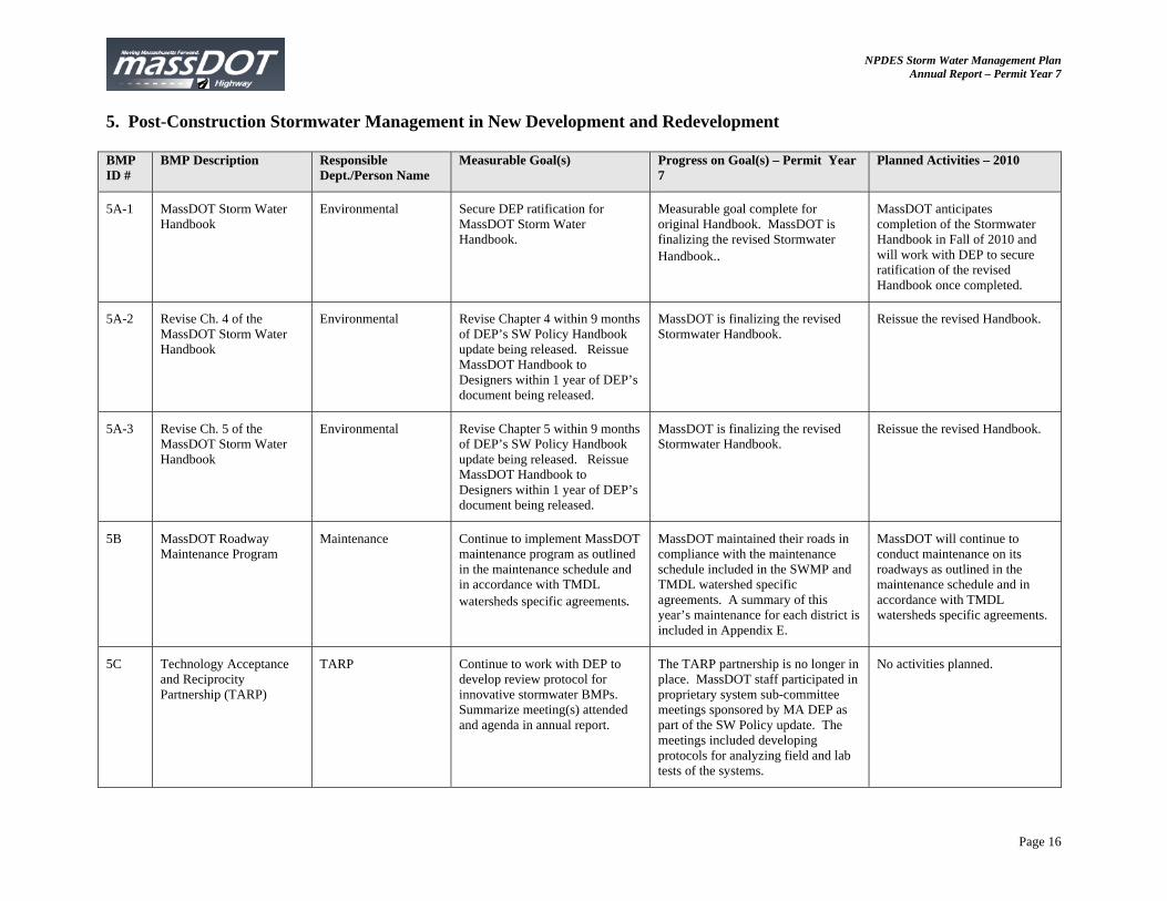
5. Post-Construction Stormwater Management in New Development and Redevelopment BMP ID #
BMP Description Responsible Dept./Person Name
Measurable Goal(s) Progress on Goal(s) – Permit Year 7
Planned Activities – 2010
5A-1 MassDOT Storm Water Handbook
Environmental Secure DEP ratification for MassDOT Storm Water Handbook.
Measurable goal complete for original Handbook. MassDOT is finalizing the revised Stormwater Handbook..
MassDOT anticipates completion of the Stormwater Handbook in Fall of 2010 and will work with DEP to secure ratification of the revised Handbook once completed.
5A-2 Revise Ch. 4 of the MassDOT Storm Water Handbook
Environmental Revise Chapter 4 within 9 months of DEP’s SW Policy Handbook update being released. Reissue MassDOT Handbook to Designers within 1 year of DEP’s document being released.
MassDOT is finalizing the revised Stormwater Handbook.
Reissue the revised Handbook.
5A-3 Revise Ch. 5 of the MassDOT Storm Water Handbook
Environmental Revise Chapter 5 within 9 months of DEP’s SW Policy Handbook update being released. Reissue MassDOT Handbook to Designers within 1 year of DEP’s document being released.
MassDOT is finalizing the revised Stormwater Handbook.
Reissue the revised Handbook.
5B MassDOT Roadway Maintenance Program
Maintenance Continue to implement MassDOT maintenance program as outlined in the maintenance schedule and in accordance with TMDL watersheds specific agreements.
MassDOT maintained their roads in compliance with the maintenance schedule included in the SWMP and TMDL watershed specific agreements. A summary of this year’s maintenance for each district is included in Appendix E.
MassDOT will continue to conduct maintenance on its roadways as outlined in the maintenance schedule and in accordance with TMDL watersheds specific agreements.
5C Technology Acceptance and Reciprocity Partnership (TARP)
TARP Continue to work with DEP to develop review protocol for innovative stormwater BMPs. Summarize meeting(s) attended and agenda in annual report.
The TARP partnership is no longer in place. MassDOT staff participated in proprietary system sub-committee meetings sponsored by MA DEP as part of the SW Policy update. The meetings included developing protocols for analyzing field and lab tests of the systems.
No activities planned.
NPDES Storm Water Management Plan Annual Report – Permit Year 7
Page 17
BMP ID #
BMP Description Responsible Dept./Person Name
Measurable Goal(s) Progress on Goal(s) – Permit Year 7
Planned Activities – 2010
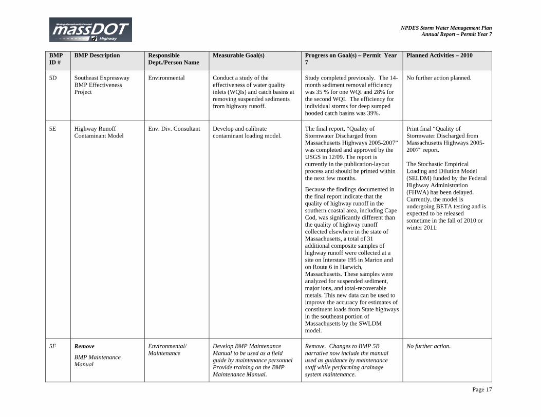
5D Southeast Expressway BMP Effectiveness Project
Environmental Conduct a study of the effectiveness of water quality inlets (WQIs) and catch basins at removing suspended sediments from highway runoff.
Study completed previously. The 14-month sediment removal efficiency was 35 % for one WQI and 28% for the second WQI. The efficiency for individual storms for deep sumped hooded catch basins was 39%.
No further action planned.
5E Highway Runoff Contaminant Model
Env. Div. Consultant Develop and calibrate contaminant loading model.
The final report, “Quality of Stormwater Discharged from Massachusetts Highways 2005-2007” was completed and approved by the USGS in 12/09. The report is currently in the publication-layout process and should be printed within the next few months.
Because the findings documented in the final report indicate that the quality of highway runoff in the southern coastal area, including Cape Cod, was significantly different than the quality of highway runoff collected elsewhere in the state of Massachusetts, a total of 31 additional composite samples of highway runoff were collected at a site on Interstate 195 in Marion and on Route 6 in Harwich, Massachusetts. These samples were analyzed for suspended sediment, major ions, and total-recoverable metals. This new data can be used to improve the accuracy for estimates of constituent loads from State highways in the southeast portion of Massachusetts by the SWLDM model.
Print final “Quality of Stormwater Discharged from Massachusetts Highways 2005-2007” report. The Stochastic Empirical Loading and Dilution Model (SELDM) funded by the Federal Highway Administration (FHWA) has been delayed. Currently, the model is undergoing BETA testing and is expected to be released sometime in the fall of 2010 or winter 2011.
5F Remove
BMP Maintenance Manual
Environmental/ Maintenance
Develop BMP Maintenance Manual to be used as a field guide by maintenance personnel Provide training on the BMP Maintenance Manual.
Remove. Changes to BMP 5B narrative now include the manual used as guidance by maintenance staff while performing drainage system maintenance.
No further action.
NPDES Storm Water Management Plan Annual Report – Permit Year 7
Page 18
BMP ID #
BMP Description Responsible Dept./Person Name
Measurable Goal(s) Progress on Goal(s) – Permit Year 7
Planned Activities – 2010
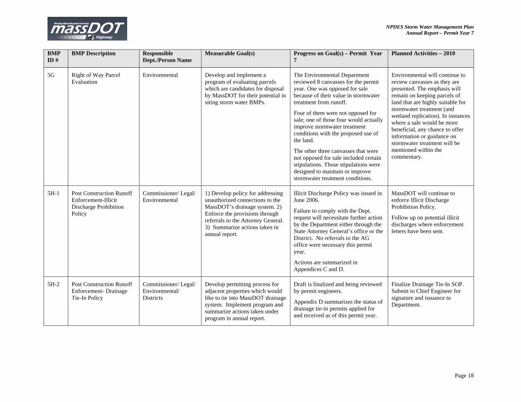
5G Right of Way Parcel Evaluation
Environmental Develop and implement a program of evaluating parcels which are candidates for disposal by MassDOT for their potential in siting storm water BMPs.
The Environmental Department reviewed 8 canvasses for the permit year. One was opposed for sale because of their value in stormwater treatment from runoff.
Four of them were not opposed for sale; one of those four would actually improve stormwater treatment conditions with the proposed use of the land.
The other three canvasses that were not opposed for sale included certain stipulations. Those stipulations were designed to maintain or improve stormwater treatment conditions.
Environmental will continue to review canvasses as they are presented. The emphasis will remain on keeping parcels of land that are highly suitable for stormwater treatment (and wetland replication). In instances where a sale would be more beneficial, any chance to offer information or guidance on stormwater treatment will be mentioned within the commentary.
5H-1 Post Construction Runoff Enforcement-Illicit Discharge Prohibition Policy
Commissioner/ Legal/ Environmental
1) Develop policy for addressing unauthorized connections to the MassDOT’s drainage system. 2) Enforce the provisions through referrals to the Attorney General. 3) Summarize actions taken in annual report.
Illicit Discharge Policy was issued in June 2006.
Failure to comply with the Dept. request will necessitate further action by the Department either through the State Attorney General’s office or the District. No referrals to the AG office were necessary this permit year.
Actions are summarized in Appendices C and D.
MassDOT will continue to enforce Illicit Discharge Prohibition Policy.
Follow up on potential illicit discharges where enforcement letters have been sent.
5H-2 Post Construction Runoff Enforcement- Drainage Tie-In Policy
Commissioner/ Legal/ Environmental/ Districts
Develop permitting process for adjacent properties which would like to tie into MassDOT drainage system. Implement program and summarize actions taken under program in annual report.
Draft is finalized and being reviewed by permit engineers.
Appendix D summarizes the status of drainage tie-in permits applied for and received as of this permit year.
Finalize Drainage Tie-In SOP. Submit to Chief Engineer for signature and issuance to Department.
NPDES Storm Water Management Plan Annual Report – Permit Year 7
Page 19
BMP ID #
BMP Description Responsible Dept./Person Name
Measurable Goal(s) Progress on Goal(s) – Permit Year 7
Planned Activities – 2010
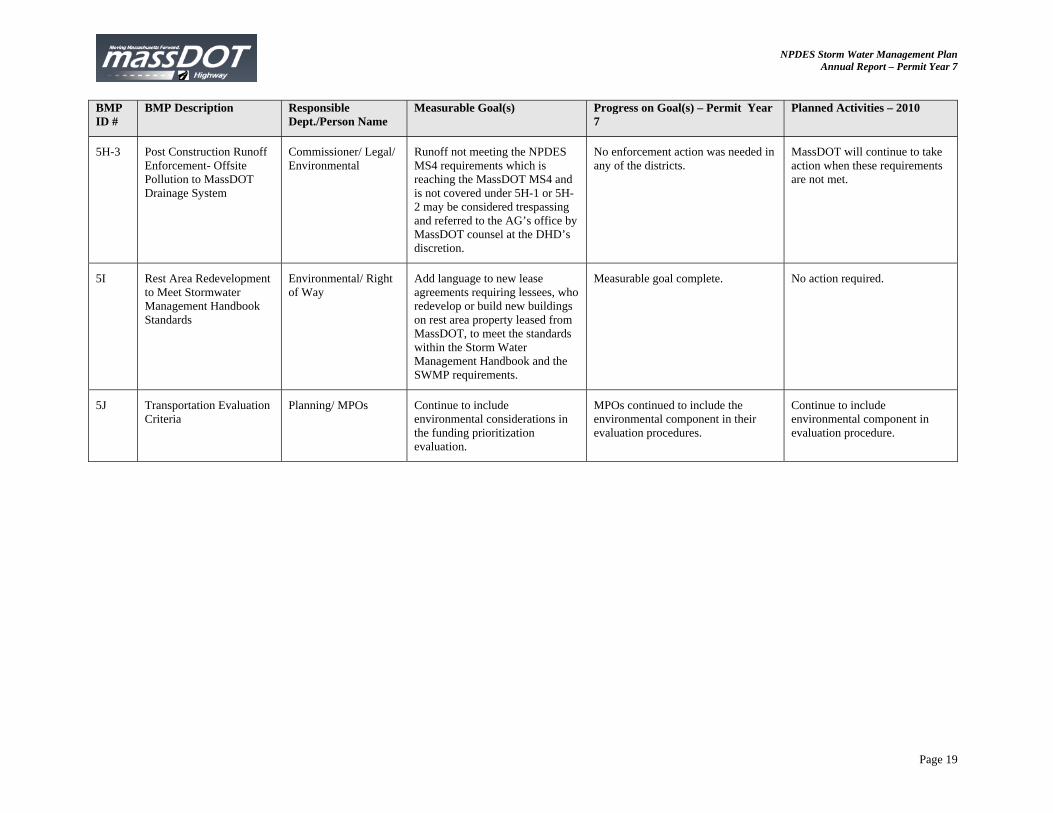
5H-3 Post Construction Runoff Enforcement- Offsite Pollution to MassDOT Drainage System
Commissioner/ Legal/ Environmental
Runoff not meeting the NPDES MS4 requirements which is reaching the MassDOT MS4 and is not covered under 5H-1 or 5H-2 may be considered trespassing and referred to the AG’s office by MassDOT counsel at the DHD’s discretion.
No enforcement action was needed in any of the districts.
MassDOT will continue to take action when these requirements are not met.
5I Rest Area Redevelopment to Meet Stormwater Management Handbook Standards
Environmental/ Right of Way
Add language to new lease agreements requiring lessees, who redevelop or build new buildings on rest area property leased from MassDOT, to meet the standards within the Storm Water Management Handbook and the SWMP requirements.
Measurable goal complete. No action required.
5J Transportation Evaluation Criteria
Planning/ MPOs Continue to include environmental considerations in the funding prioritization evaluation.
MPOs continued to include the environmental component in their evaluation procedures.
Continue to include environmental component in evaluation procedure.
NPDES Storm Water Management Plan Annual Report – Permit Year 7
Page 20
BMP ID #
BMP Description Responsible Dept./Person Name
Measurable Goal(s) Progress on Goal(s) – Permit Year 7
Planned Activities – 2010
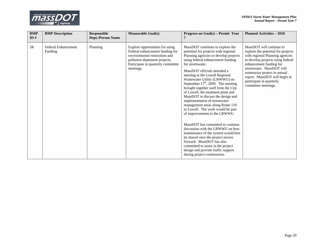
5K Federal Enhancement Funding
Planning Explore opportunities for using Federal enhancement funding for environmental restoration and pollution abatement projects. Participate in quarterly committee meetings.
MassDOT continues to explore the potential for projects with regional Planning agencies to develop projects using federal enhancement funding for stormwater.
MassDOT officials attended a meeting at the Lowell Regional Wastewater Utility (LRWWU) on September 17th, 2009. The meeting brought together staff from the City of Lowell, the treatment plant and MassDOT to discuss the design and implementation of stormwater management areas along Route 110 in Lowell. The work would be part of improvements to the LRWWU.
MassDOT has committed to continue discussion with the LRWWU on how maintenance of the system would best be shared once the project moves forward. MassDOT has also committed to assist in the project design and provide traffic support during project construction.
MassDOT will continue to explore the potential for projects with regional Planning agencies to develop projects using federal enhancement funding for stormwater. MassDOT will summarize project in annual report. MassDOT will begin to participate in quarterly committee meetings.
NPDES Storm Water Management Plan Annual Report – Permit Year 7
Page 21
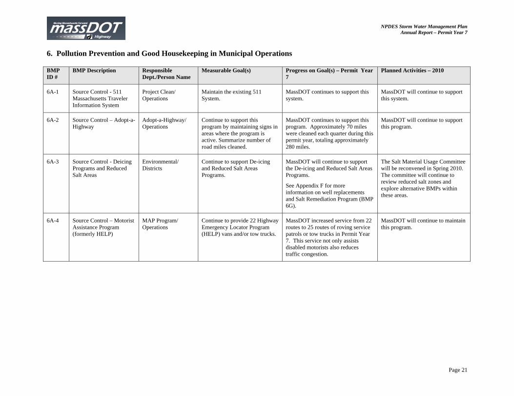
6. Pollution Prevention and Good Housekeeping in Municipal Operations BMP ID #
BMP Description Responsible Dept./Person Name
Measurable Goal(s) Progress on Goal(s) – Permit Year 7
Planned Activities – 2010
6A-1 Source Control - 511 Massachusetts Traveler Information System
Project Clean/ Operations
Maintain the existing 511 System.
MassDOT continues to support this system.
MassDOT will continue to support this system.
6A-2 Source Control – Adopt-a-Highway
Adopt-a-Highway/ Operations
Continue to support this program by maintaining signs in areas where the program is active. Summarize number of road miles cleaned.
MassDOT continues to support this program. Approximately 70 miles were cleaned each quarter during this permit year, totaling approximately 280 miles.
MassDOT will continue to support this program.
6A-3 Source Control - Deicing Programs and Reduced Salt Areas
Environmental/ Districts
Continue to support De-icing and Reduced Salt Areas Programs.
MassDOT will continue to support the De-icing and Reduced Salt Areas Programs.
See Appendix F for more information on well replacements and Salt Remediation Program (BMP 6G).
The Salt Material Usage Committee will be reconvened in Spring 2010. The committee will continue to review reduced salt zones and explore alternative BMPs within these areas.
6A-4 Source Control – Motorist Assistance Program (formerly HELP)
MAP Program/ Operations
Continue to provide 22 Highway Emergency Locator Program (HELP) vans and/or tow trucks.
MassDOT increased service from 22 routes to 25 routes of roving service patrols or tow trucks in Permit Year 7. This service not only assists disabled motorists also reduces traffic congestion.
MassDOT will continue to maintain this program.

NPDES Storm Water Management Plan Annual Report – Permit Year 7
Page 22
BMP ID #
BMP Description Responsible Dept./Person Name
Measurable Goal(s) Progress on Goal(s) – Permit Year 7
Planned Activities – 2010
6A-5 Source Control - VMP Environmental 1) Develop a generic Vegetation Management Plan (VMP) which outlines methods of minimizing the discharge of pollutants related to the storage and application of pesticides, herbicides, and fertilizers. 2) Prepare a Yearly Operational Plan (YOP) by April of each year. 3) Post YOP on web site within 30 days. 4) Summarize actions taken in previous year in annual report.
1) MassDOT completed The Five-Year 2009-2013 Vegetation Management Plan and posted it on the web. The plan is for proposed limited use of herbicides as part of overall vegetation management plan.
2) The Yearly Operational Plan is complete and describes locations, and materials proposed for application. In general, any application of fertilizers or herbicides in 2009 was by Contractor; MHD did not store these materials.
3) The 2009 YOP was posted in 2009 at http://www.mhd.state.ma. us/default.asp?pgid =content/publicationother &sid=about
4) Application of fertilizers has been limited to establishment of grasses for erosion control on construction projects. Application of herbicides was limited to treatment of invasive plants.
MassDOT will complete its 2009 YOP and post it on the web within 30 days of completion. There may be increased use of herbicides for treatment of guardrail, barrier, and curb on high-speed, high-volume locations where mechanical removal is not feasible.
6A-6 Source Control - HOV Planning Continue participation in ridesharing activities through the duration of the permit term.
MassDOT continues to support this program
MassDOT will continue to support this program.
6A-7 Source Control - Alternative Transportation
Planning Provide technical assistance and funding for bicycling and walking, including on-road and off-road improvements, at the local level.
Fiscal Year 2009 Bicycle and Walking Budget for MassDOT: $10,861,547.
$713,000 was used for bicycle and walking infrastructure improvements as part of the Safe Route to School Program Budget.
Fiscal Year 2010 Bicycle and Walking Budget for MassDOT: $20,203,099.
$2,767,000 will be used for bicycle and walking infrastructure improvements as part of the Safe Route to School Program Budget.
NPDES Storm Water Management Plan Annual Report – Permit Year 7
Page 23
BMP ID #
BMP Description Responsible Dept./Person Name
Measurable Goal(s) Progress on Goal(s) – Permit Year 7
Planned Activities – 2010
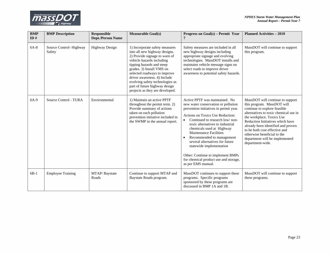
6A-8 Source Control- Highway Safety
Highway Design 1) Incorporate safety measures into all new highway designs. 2) Provide signage to warn of vehicle hazards including tipping hazards and steep grades. 3) Install VMS on selected roadways to improve driver awareness. 4) Include evolving safety technologies as part of future highway design projects as they are developed.
Safety measures are included in all new highway designs including appropriate signage and evolving technologies. MassDOT installs and maintains vehicle message signs on select roads to improve driver awareness to potential safety hazards.
MassDOT will continue to support this program.
6A-9 Source Control - TURA Environmental 1) Maintain an active PPTF throughout the permit term. 2) Provide summary of actions taken on each pollution prevention initiative included in the SWMP in the annual report.
Active PPTF was maintained. No new water conservation or pollution prevention initiatives in permit year.
Actions on Toxics Use Reduction: Continued to research low/ non-
toxic alternatives to industrial chemicals used at Highway Maintenance Facilities
Recommended to management several alternatives for future statewide implementation
Other: Continue to implement BMPs for chemical product use and storage, as per EMS manual.
MassDOT will continue to support this program. MassDOT will continue to explore feasible alternatives to toxic chemical use in the workplace. Toxics Use Reduction Initiatives which have already been identified and proven to be both cost effective and otherwise beneficial to the department will be implemented department-wide.
6B-1 Employee Training MTAP/ Baystate Roads
Continue to support MTAP and Baystate Roads program.
MassDOT continues to support these programs. Specific programs sponsored by these programs are discussed in BMP 1A and 1B.
MassDOT will continue to support these programs.
NPDES Storm Water Management Plan Annual Report – Permit Year 7
Page 24
BMP ID #
BMP Description Responsible Dept./Person Name
Measurable Goal(s) Progress on Goal(s) – Permit Year 7
Planned Activities – 2010
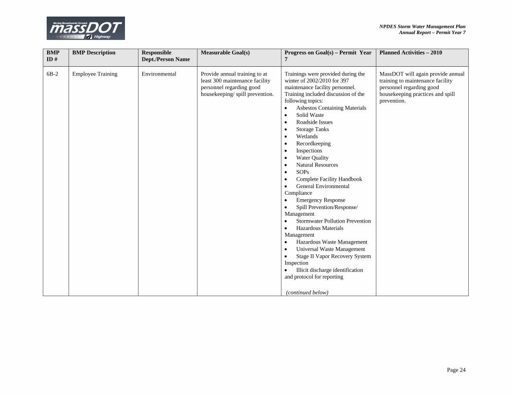
6B-2 Employee Training Environmental Provide annual training to at least 300 maintenance facility personnel regarding good housekeeping/ spill prevention.
Trainings were provided during the winter of 2002/2010 for 397 maintenance facility personnel. Training included discussion of the following topics: Asbestos Containing Materials Solid Waste Roadside Issues Storage Tanks Wetlands Recordkeeping Inspections Water Quality Natural Resources SOPs Complete Facility Handbook General Environmental Compliance Emergency Response Spill Prevention/Response/ Management Stormwater Pollution Prevention Hazardous Materials Management Hazardous Waste Management Universal Waste Management Stage II Vapor Recovery System Inspection Illicit discharge identification and protocol for reporting
(continued below)
MassDOT will again provide annual training to maintenance facility personnel regarding good housekeeping practices and spill prevention.
NPDES Storm Water Management Plan Annual Report – Permit Year 7
Page 25
BMP ID #
BMP Description Responsible Dept./Person Name
Measurable Goal(s) Progress on Goal(s) – Permit Year 7
Planned Activities – 2010
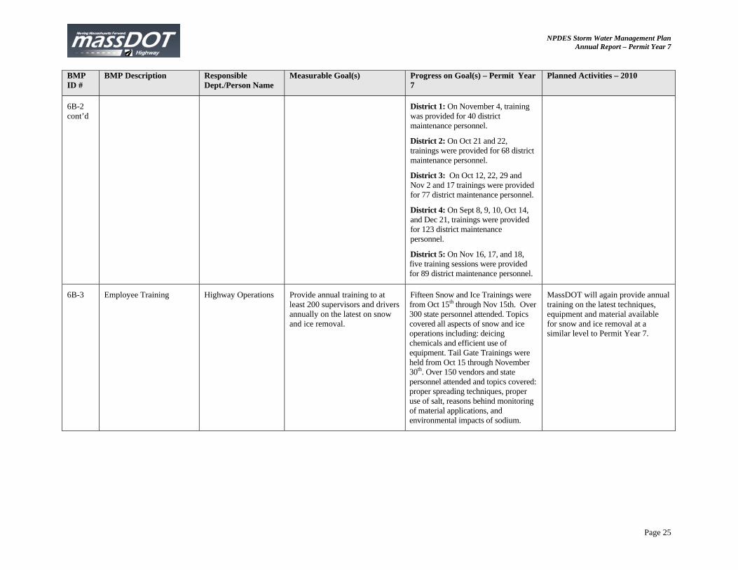
6B-2 cont’d
District 1: On November 4, training was provided for 40 district maintenance personnel.
District 2: On Oct 21 and 22, trainings were provided for 68 district maintenance personnel.
District 3: On Oct 12, 22, 29 and Nov 2 and 17 trainings were provided for 77 district maintenance personnel.
District 4: On Sept 8, 9, 10, Oct 14, and Dec 21, trainings were provided for 123 district maintenance personnel.
District 5: On Nov 16, 17, and 18, five training sessions were provided for 89 district maintenance personnel.
6B-3 Employee Training Highway Operations Provide annual training to at least 200 supervisors and drivers annually on the latest on snow and ice removal.
Fifteen Snow and Ice Trainings were from Oct 15th through Nov 15th. Over 300 state personnel attended. Topics covered all aspects of snow and ice operations including: deicing chemicals and efficient use of equipment. Tail Gate Trainings were held from Oct 15 through November 30th. Over 150 vendors and state personnel attended and topics covered: proper spreading techniques, proper use of salt, reasons behind monitoring of material applications, and environmental impacts of sodium.
MassDOT will again provide annual training on the latest techniques, equipment and material available for snow and ice removal at a similar level to Permit Year 7.
NPDES Storm Water Management Plan Annual Report – Permit Year 7
Page 26
BMP ID #
BMP Description Responsible Dept./Person Name
Measurable Goal(s) Progress on Goal(s) – Permit Year 7
Planned Activities – 2010
6B-4 Employee Training Highway Operations Ensure all equipment and vehicle operators have received training on the proper operation of the equipment and vehicles they operate.
Training were held throughout the year on topics as follows: Right to Know (January) Crash Attenuator Training
(March) Workzone Safety Training
(March and April) Attenuator Truck and Trailer
Training (Spring) Deck, Zero Track and Guardrail
Mower Training (Summer) Wood Chipper Operations
(Summer) Outdoor Hazards (Summer) Litter Picker Attachment
Training (August) 2-ton Asphalt Reclaimer
Training (September) John Deere Skid-Steer-
Excavator Training (September) Snow & Ice Training
(September) Overguard Rail John Deere
Mower (October) Operation of Fork Lift Truck
Equipment (Fall) Hot Box Training -New and Old
(Fall)
F-450 Aerial Truck Training (December)
MassDOT will provide Operational, Safety, and Maintenance training on Vactor Trucks, sweepers, mowers, snow and ice, as well as refresher courses pertaining to the 2009 list.
6C-1 Maintenance Districts Continue to implement maintenance schedule outlined in Appendix E of the SWMP.
MassDOT continued to maintain the highway system through catch basin cleaning contracts, street sweeping and regular drainage system maintenance. See Appendix E of the annual report for a summary of compliance.
MassDOT will continue to maintain the highway system through catch basin cleaning contracts, street sweeping and regular drainage system maintenance in compliance with Appendix E of the SWMP.
NPDES Storm Water Management Plan Annual Report – Permit Year 7
Page 27
BMP ID #
BMP Description Responsible Dept./Person Name
Measurable Goal(s) Progress on Goal(s) – Permit Year 7
Planned Activities – 2010
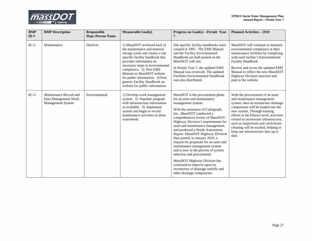
6C-2 Maintenance Districts 1) MassDOT reviewed each of the maintenance and material storage yards and creates a site specific facility handbook that provides information on necessary steps to environmental compliance. 2) Post EMS Manual on MassDOT website for public information. 3) Post generic Facility Handbook on website for public information.
Site specific facility handbooks were created in 1995. The EMS Manual and the Facility Environmental Handbook are both posted on the MassDOT web site.
In Permit Year 7, the updated EMS Manual was reviewed. The updated Facilities Environmental Handbook was also distributed.
MassDOT will continue to maintain environmental compliance at their maintenance facilities by complying with each facility’s Environmental Facility Handbook.
Review and revise the updated EMS Manual to reflect the new MassDOT Highway Division structure and post to the website.
6C-3 Maintenance Record and Data Management Work Management System
Environmental 1) Develop work management system. 2) Populate program with infrastructure information as available. 3) Implement system and begin to record maintenance activities in these watersheds.
MassDOT is the procurement phase for an asset and maintenance management system.
With the assistance of Cartegraph, Inc., MassDOT conducted a comprehensive review of MassDOT-Highway Division’s requirements for asset and maintenance management, and produced a Needs Assessment Report. MassDOT-Highway Division then posted, in January 2010, a request for proposals for an asset and maintenance management system and is now in the process of system selection and procurement.
MassDOT-Highway Division has continued to improve upon its inventories of drainage outfalls and other drainage components.
With the procurement of an asset and maintenance management system, data on stormwater drainage components will be loaded into the new system. Through training efforts at the District level, activities related to stormwater infrastructure, such as inspections and catch-basin cleaning will be tracked, helping to keep our infrastructure data up to date.
NPDES Storm Water Management Plan Annual Report – Permit Year 7
Page 28
BMP ID #
BMP Description Responsible Dept./Person Name
Measurable Goal(s) Progress on Goal(s) – Permit Year 7
Planned Activities – 2010
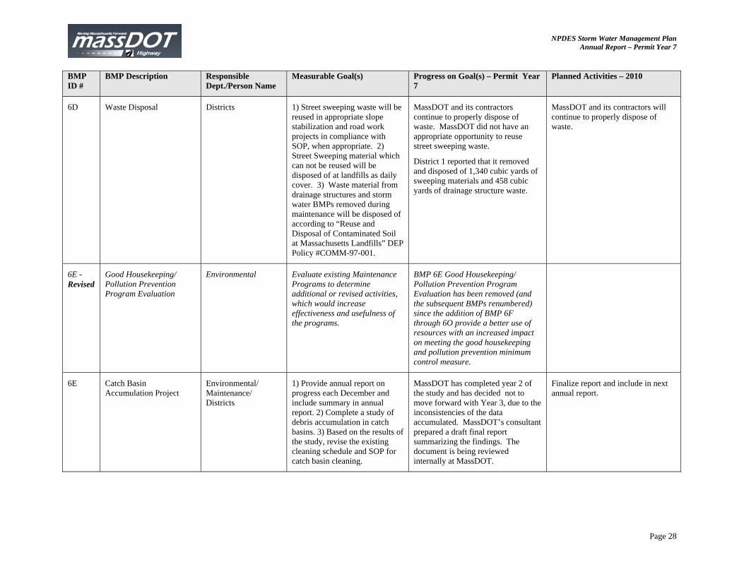
6D Waste Disposal Districts 1) Street sweeping waste will be reused in appropriate slope stabilization and road work projects in compliance with SOP, when appropriate. 2) Street Sweeping material which can not be reused will be disposed of at landfills as daily cover. 3) Waste material from drainage structures and storm water BMPs removed during maintenance will be disposed of according to “Reuse and Disposal of Contaminated Soil at Massachusetts Landfills” DEP Policy #COMM-97-001.
MassDOT and its contractors continue to properly dispose of waste. MassDOT did not have an appropriate opportunity to reuse street sweeping waste.
District 1 reported that it removed and disposed of 1,340 cubic yards of sweeping materials and 458 cubic yards of drainage structure waste.
MassDOT and its contractors will continue to properly dispose of waste.
6E - Revised
Good Housekeeping/ Pollution Prevention Program Evaluation
Environmental Evaluate existing Maintenance Programs to determine additional or revised activities, which would increase effectiveness and usefulness of the programs.
BMP 6E Good Housekeeping/ Pollution Prevention Program Evaluation has been removed (and the subsequent BMPs renumbered) since the addition of BMP 6F through 6O provide a better use of resources with an increased impact on meeting the good housekeeping and pollution prevention minimum control measure.
6E Catch Basin Accumulation Project
Environmental/ Maintenance/ Districts
1) Provide annual report on progress each December and include summary in annual report. 2) Complete a study of debris accumulation in catch basins. 3) Based on the results of the study, revise the existing cleaning schedule and SOP for catch basin cleaning.
MassDOT has completed year 2 of the study and has decided not to move forward with Year 3, due to the inconsistencies of the data accumulated. MassDOT’s consultant prepared a draft final report summarizing the findings. The document is being reviewed internally at MassDOT.
Finalize report and include in next annual report.
NPDES Storm Water Management Plan Annual Report – Permit Year 7
Page 29
BMP ID #
BMP Description Responsible Dept./Person Name
Measurable Goal(s) Progress on Goal(s) – Permit Year 7
Planned Activities – 2010
6F Policy and Program Review
Environmental MassDOT will continue to at least biannually evaluate its snow and ice control policies and operational programs in order to make adjustments based on data and experience, and to respond to changing conditions.
MassDOT reviewed the policies in April 2009 and March 2010. Changes and updates include: evaluation of material spreaders controllers for efficiency, change in equipment requirements for material spreaders for pre-wetting. MassDOT has established a program so that all material spreaders will have Closed Loop Systems by 2014.
Continue to evaluate program and implement changes as determined beneficial. Establish a Salt Brine Facility in District 5.
6G Salt Remediation Program Environmental. Maintenance/ Districts
Continue to provide the Salt Remediation Program with a funding level appropriate to quickly address salt related complaints.
Funding provided through new ISA - $4.75 million through June 2011.
The Public Well Supply Matrix included in the December 2009 SWMP is included as Appendix F of this annual report to summarize the current status of each public well included in the Salt Remediation Program.
The Andover runoff study and Dedham-Westwood aquifer study will continue.
Field monitoring of public water supply wells will continue with funding provided by the ISA.
NPDES Storm Water Management Plan Annual Report – Permit Year 7
Page 30
BMP ID #
BMP Description Responsible Dept./Person Name
Measurable Goal(s) Progress on Goal(s) – Permit Year 7
Planned Activities – 2010
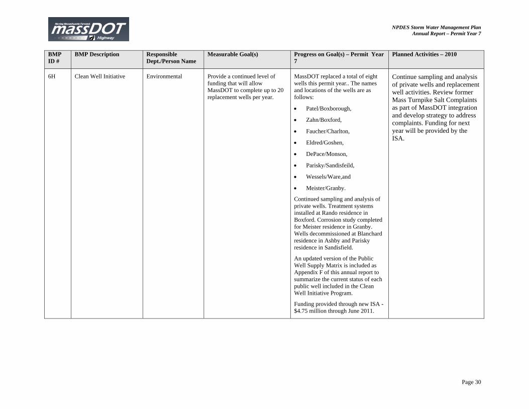
6H Clean Well Initiative Environmental Provide a continued level of funding that will allow MassDOT to complete up to 20 replacement wells per year.
MassDOT replaced a total of eight wells this permit year.. The names and locations of the wells are as follows:
Patel/Boxborough,
Zahn/Boxford,
Faucher/Charlton,
Eldred/Goshen,
DePace/Monson,
Parisky/Sandisfeild,
Wessels/Ware,and
Meister/Granby.
Continued sampling and analysis of private wells. Treatment systems installed at Rando residence in Boxford. Corrosion study completed for Meister residence in Granby. Wells decommissioned at Blanchard residence in Ashby and Parisky residence in Sandisfield.
An updated version of the Public Well Supply Matrix is included as Appendix F of this annual report to summarize the current status of each public well included in the Clean Well Initiative Program.
Funding provided through new ISA - $4.75 million through June 2011.
Continue sampling and analysis of private wells and replacement well activities. Review former Mass Turnpike Salt Complaints as part of MassDOT integration and develop strategy to address complaints. Funding for next year will be provided by the ISA.
NPDES Storm Water Management Plan Annual Report – Permit Year 7
Page 31
BMP ID #
BMP Description Responsible Dept./Person Name
Measurable Goal(s) Progress on Goal(s) – Permit Year 7
Planned Activities – 2010
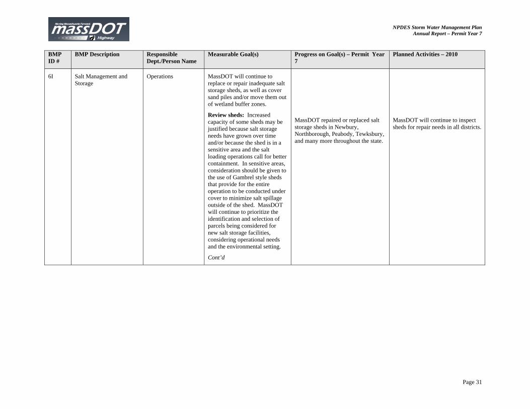
6I Salt Management and Storage
Operations MassDOT will continue to replace or repair inadequate salt storage sheds, as well as cover sand piles and/or move them out of wetland buffer zones.
Review sheds: Increased capacity of some sheds may be justified because salt storage needs have grown over time and/or because the shed is in a sensitive area and the salt loading operations call for better containment. In sensitive areas, consideration should be given to the use of Gambrel style sheds that provide for the entire operation to be conducted under cover to minimize salt spillage outside of the shed. MassDOT will continue to prioritize the identification and selection of parcels being considered for new salt storage facilities, considering operational needs and the environmental setting.
Cont’d
MassDOT repaired or replaced salt storage sheds in Newbury, Northborough, Peabody, Tewksbury, and many more throughout the state.
MassDOT will continue to inspect sheds for repair needs in all districts.
NPDES Storm Water Management Plan Annual Report – Permit Year 7
Page 32
BMP ID #
BMP Description Responsible Dept./Person Name
Measurable Goal(s) Progress on Goal(s) – Permit Year 7
Planned Activities – 2010
6I cont’d
Review Sand Piles: MassDOT will strive to locate sand piles outside wetland buffer zones whenever space allows. However, when this is not possible the department will work towards storing sand piles under cover, especially during the non-winter months. This could be accomplished by storing sand within sheds or, more likely, using a heavy-gauge polyethylene tarp. The tarp could be peeled back once, before winter operations, and then covered again at the end of the season. Personnel: In October 2006, MassDOT hired a Director of Snow & Ice Operations, with over 20 years of experience in winter operations, to improve salt management and supervision of deicing operations.
Review sand piles: All fabric sheds have been inspected and recommendations have gone to the respective districts for repair. Several fabric sheds have been repaired.
Director has continued to improve salt management and supervision of deicing operations.
Several fabrics sheds are scheduled to be repaired this summer. MassDOT will continue to monitor sand piles and fabric sheds.
Director will continue to oversee salt management and supervision of deicing operations.
Other planned activities: MassDOT is planning to replace several facilities in sensitive areas. Solid structures are being reviewed and have been scheduled for repair in 2010.
6J Salt Storage Best Management Practices/ Pollution Prevention
Environmental Continue to implement salt storage in compliance with DEP Guidelines on Deicing Chemical Storage. Continue to follow MassDOT SOP for the Management of Sand and Deicing Chemicals at MassDOT Facilities. Continue to follow Facility Environmental Handbook guidelines at maintenance facilities.
MassDOT currently includes the SOP as standard part of program to remind all involved in Snow and Ice Operations the importance of paying attention to detail.
MassDOT will continue to enforce the SOP for Management of Sand and Deicing Chemicals at MassDOT Facilities.
NPDES Storm Water Management Plan Annual Report – Permit Year 7
Page 33
BMP ID #
BMP Description Responsible Dept./Person Name
Measurable Goal(s) Progress on Goal(s) – Permit Year 7
Planned Activities – 2010
6K Equipment Improvements Environmental MassDOT will continue to expand the use of anti-icing as a standard tool for snow and ice control.
MassDOT has a tank truck for anti-icing in each depot other than District 5. MassDOT had 125 trucks available this past winter. This reflects approximately a 10% increase in equipment availability. Expansion in District 5 will occur as soon as a brine facility is developed.
MassDOT will build a salt brine facility in District 5. This facility will support Cape Cod and the South Shore where temperatures are milder and more moderate.
6L Enhanced Weather Forecasting Information
Environmental Continue to provide sufficient funding to use weather forecasting contractor to provide up-to-date and local weather information during snow and ice season.
MassDOT has worked very closely with the current provider to continually improve the weather forecast. Contract is up for rebid. Funding has been committed, because of the rebid.
Rebid this summer and again work to fine tune weather forecast.
6M Road Weather Information System
Environmental MassDOT will ensure that these stations will be maintained so as to remain fully functional.
MassDOT is in the evaluation phase of the contract process for the RWIS. Two new systems were added in District 1 at Sandisfield and Sheffield. They were completed installed and are functional.
Contract for RWIS will be rebid this summer.
MassDOT will add a new system in the next permit year in Merrimac on the upper end of Route 495.
6N Alternative Technologies Environmental MassDOT will continue to maximize the use of Premix and liquid calcium chloride, as alternative deicers, to reduce the quantity of granular sodium chloride, and should closely monitor reduced salt zones during storms to ensure the proper timing of salt applications and to minimize the potential for overuse of deicing chemicals.
Pre-Mix continues to be used when appropriate. The increased use of magnesium chloride (MgCl) for Pre-Wetting has continued to maximize the effectiveness of salt while reducing overall use of deicers. Almost 60% of de-icing chemical used on MassDOT roads (former MassHighway roads) is.MgCl. This has significantly reduced the amount of solid chemical we apply. It works longer and better than dry salt alone.
MassDOT plans to increase use of MgCl to almost 75% and continue to utilize pre-wetting and anti-icing strategies to reduce overall salt use.
NPDES Storm Water Management Plan Annual Report – Permit Year 7
Page 34
BMP ID #
BMP Description Responsible Dept./Person Name
Measurable Goal(s) Progress on Goal(s) – Permit Year 7
Planned Activities – 2010
6O Research Operations MassDOT has joined Clear Roads program and will continue to explore moving forward on other projects. Summarize research performed.
Massachusetts has continued to commit resources towards Clear Roads and MassDOT continues to be active member in the Clear Roads program. Paul Brown (of MassDOT Operations) is currently the chair of committee. During this permit year several projects were in progress. Research continues to assist MassDOT by bringing the most current practices to operations.
Research conducted this permit year included chemical guidelines for anti-icing, use of liquids to reduce the amount of solid chemicals applied, the true cost of winter activities, use of zero velocity spreaders.
Highlights of July 2009 annual meeting included: MassDOT chaired the meeting; the increased use of blends of chemicals and the impact on the use of salt brine; states trying to do more with less; and new strategies for dealing with legal, environmental, and political realities of winter operations.
Research planned for the next permit year includes corrosion on snow equipment and expanded use of de-icing chemicals.
Addn MassDOT Research Needs Program (Previously indicated as BMP 4G but focus of research program is now for source control instead of construction)
Environmental/ Construction
Continue funding the MassDOT Research Needs Program.
MassDOT executed and awarded a $300k contract for study on Critical Operational Factors that Affect Road Salt Usage and the Effectiveness and Efficiency of Salt Spreading Operations and Equipment. Winter data collection survey commenced in December of 2009. Winter operations commenced in February 2010. Consultant monitored operations for three storms.
Consultant will continue to collect salt usage data throughout March and April 2010. Consultant will continue data collection and monitoring and will begin GIS mapping preparation for use in the program. GIS mapping for Public Drinking Water Supply Zone II is planned for April 210.
NPDES Storm Water Management Plan Annual Report – Permit Year 7
Page 35
7. BMPs for Meeting Total Maximum Daily Load (TMDL) Waste Load Allocations (WLA) <<if applicable>> BMP ID #
BMP Description Responsible Dept./Person Name
Measurable Goal(s) Progress on Goal(s) – Permit Year 7
Planned Activities – 2010
7A Wetland Protection Act (WPA) Compliance
Environmental 1) All MassDOT projects will comply with the WPA and MESA. 2) When potential impacts are identified, MassDOT will work with the appropriate agencies to design the project to minimize the impacts.
Continue to comply with MESA as required by the WPA.
Continue to comply with MESA as required by the WPA.
7B 401 Water Quality Certification
Environmental Massachusetts’s 401 Water Quality certification requirements, which include review of the project by MA Natural Heritage program and US Fish and Wildlife if endangered species habitat is mapped in the project vicinity, will be complied with whenever they are applicable.
Continue to comply with MA 401 Water Quality Certification Regulations.
Continue to comply with MA 401 Water Quality Certification Regulations.
7C CE Checklist Environmental Complete a Categorical Exclusion Checklist for all MassDOT projects that utilize federal funds.
152 Categorical Exclusion (CE) checklists were completed and approved for all federally-aided projects advertised for construction by MassDOT during Permit Year 7. All documentation supporting the MassDOT’s determination of a project meeting the definition of a CE is on file with Environmental Services Department at MassDOT Highway Division.
Complete and approve 150 to 200 Categorical Checklists for the current federally-aided construction advertising program. Complete this checklist at 25% design stage for other project that receives federal funds.
NPDES Storm Water Management Plan Annual Report – Permit Year 7
Page 36
BMP ID #
BMP Description Responsible Dept./Person Name
Measurable Goal(s) Progress on Goal(s) – Permit Year 7
Planned Activities – 2010
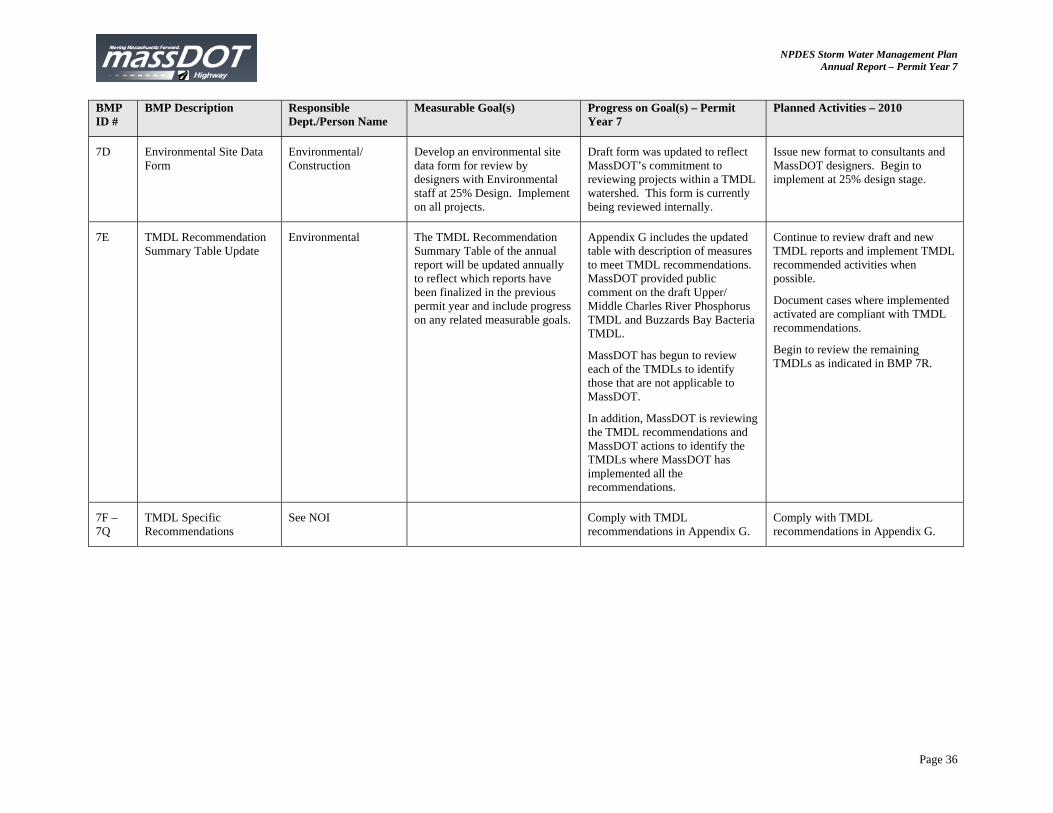
7D Environmental Site Data Form
Environmental/ Construction
Develop an environmental site data form for review by designers with Environmental staff at 25% Design. Implement on all projects.
Draft form was updated to reflect MassDOT’s commitment to reviewing projects within a TMDL watershed. This form is currently being reviewed internally.
Issue new format to consultants and MassDOT designers. Begin to implement at 25% design stage.
7E TMDL Recommendation Summary Table Update
Environmental The TMDL Recommendation Summary Table of the annual report will be updated annually to reflect which reports have been finalized in the previous permit year and include progress on any related measurable goals.
Appendix G includes the updated table with description of measures to meet TMDL recommendations. MassDOT provided public comment on the draft Upper/ Middle Charles River Phosphorus TMDL and Buzzards Bay Bacteria TMDL.
MassDOT has begun to review each of the TMDLs to identify those that are not applicable to MassDOT.
In addition, MassDOT is reviewing the TMDL recommendations and MassDOT actions to identify the TMDLs where MassDOT has implemented all the recommendations.
Continue to review draft and new TMDL reports and implement TMDL recommended activities when possible.
Document cases where implemented activated are compliant with TMDL recommendations.
Begin to review the remaining TMDLs as indicated in BMP 7R.
7F – 7Q
TMDL Specific Recommendations
See NOI Comply with TMDL recommendations in Appendix G.
Comply with TMDL recommendations in Appendix G.
NPDES Storm Water Management Plan Annual Report – Permit Year 7
Page 37
BMP ID #
BMP Description Responsible Dept./Person Name
Measurable Goal(s) Progress on Goal(s) – Permit Year 7
Planned Activities – 2010
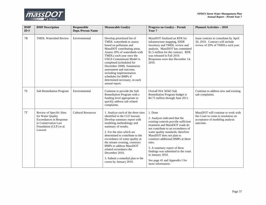
7R TMDL Watershed Review Environmental Develop prioritized list of TMDL watersheds to assess based on pollutants and MassDOT contributing areas. Assess 20% of watersheds with TMDLs each year once the USGS Contaminant Model is completed (scheduled for December 2008). Summarize assessment and outcome, including implementation schedules for BMPs if determined necessary, in each annual report.
MassDOT finalized an RFR for infrastructure mapping, IDDE inventory and TMDL review and analysis. MassDOT has committed $1.5 million for the contract. RFR was released in Fall 2010. Responses were due December 14, 2010.
Issue contract to consultant by April 30, 2010. Contract will include review of 20% of TMDLs each year.
7S Salt Remediation Program Environmental Continue to provide the Salt Remediation Program with a funding level appropriate to quickly address salt related complaints.
Overall ISA 56565 Salt Remediation Program budget is $4.75 million through June 2011.
Continue to address new and existing salt complaints.
7T Review of Specific Sites for Water Quality Exceedances in Response to Conservation Law Foundation (CLF) et al. Lawsuit
Cultural Resources 1. Analyze each of the three sites identified in the CLF lawsuit. Develop summary report with modeling methodology and summary of results.
2. For the sites which are determined to contribute to the exceedance of water quality at the stream crossing, construct BMPs to address MassDOT related exceedance the December 2010.
3. Submit a remedial plan to the courts by January 2010.
1. Done
2. Analysis indicated that the existing controls provide sufficient treatment and MassDOT roads do not contribute to an exceedance of water quality standards; therefore MassDOT does not plan to construct additional BMPs at these sites.
3. A summary report of these findings was submitted to the court in January 2010.
See page 41 and Appendix I for more information.
MassDOT will continue to work with the Court to come to resolution on acceptance of modeling analysis outcome.
NPDES Storm Water Management Plan Annual Report – Permit Year 7
Page 38
BMP ID #
BMP Description Responsible Dept./Person Name
Measurable Goal(s) Progress on Goal(s) – Permit Year 7
Planned Activities – 2010
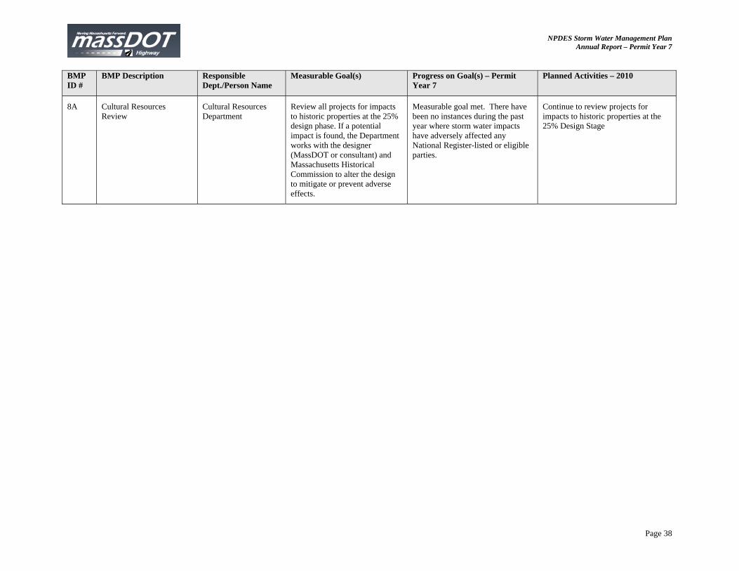
8A Cultural Resources Review
Cultural Resources Department
Review all projects for impacts to historic properties at the 25% design phase. If a potential impact is found, the Department works with the designer (MassDOT or consultant) and Massachusetts Historical Commission to alter the design to mitigate or prevent adverse effects.
Measurable goal met. There have been no instances during the past year where storm water impacts have adversely affected any National Register-listed or eligible parties.
Continue to review projects for impacts to historic properties at the 25% Design Stage
NPDES Storm Water Management Plan Annual Report – Permit Year 7
Page 39
7b. WLA Assessment Projects within a watershed with an approved TMDL are most likely subject to the Wetlands Protection Act (WPA). MassDOT projects which are subject to the WPA strive to meet the WPA’s Stormwater Policy to the greatest extent possible. Meeting the requirements of the Stormwater Policy should provide sufficient water quantity and quality controls to reduce pollutant loading to the impaired waterbodies. The attached table tracks the projects within approved TMDL watersheds and summarizes the controls implemented to meet the TMDL requirements. New design and construction projects which are proposed within a TMDL watershed will continue to incorporate measures to meet the TMDL requirements. The following projects are under design this year and are working to incorporate appropriate controls to meet Final TMDLs:
Middlesex Turnpike, Burlington/ Bedford: MassDOT has been working with its consultant on the Middlesex Turnpike project in Bedford and Burlington to incorporate BMPs to meet the Shawsheen Bacteria TMDL. Submittal of the completed certification will meet the bacteria TMDL requirements. Route 128 Add-A-Lane, Dedham: MassDOT has also been working with the Dedham Conservation Commission and MassDOT project consultants to include appropriate controls for the Route 128 Add-a-Lane project within the Charles River watershed so that the project meets the Charles River Phosphorus TMDL. MassDOT has designed infiltration BMPs to meet the 65% phosphorus reduction required by the Charles River TMDL within the limited ROW available without impacting the road substructure with the infiltration structures. The design is currently on-going. Dudley Road Reconstruction, Orange/Athol: As a part of the Route 101 (Dudley Road) Reconstruction, MassDOT is installing BMPs to address the Bourn-Hadley Pond which is an impaired waterbody in the Millers River Basin Phosphorus TMDL. BMPs include deep sump CB’s, water quality swales at new discharge locations, and removal and disposal of drainage system sediments. Route 2 Safety Improvements, Phillipston/Athol/Orange: As a part of the Route 2 Safety Improvements, MassDOT is installing BMPs to address the impaired waterbodies of Reservoir No. 1 (Athol) and No. 2 (Phillipston), Lake Ellis (Athol) and Ward Pond (Athol), Brazell Pond (Athol); Bourn-Hadley Pond; Greenwood Pond 2 and Lake Rohunta (Orange/Athol). These impaired waterbodies are each included in the Millers River Basin Phosphorus TMDL. BMPs include deep sump CB’s, detention basins, stone and grass swales, removal and disposal of drainage system sediments, annual street sweeping, and cleaning paved waterways.
NPDES Storm Water Management Plan Annual Report – Permit Year 7
Page 40
Reconstruction of Glen Allen Street (Route 202) from Maple Street Intersection to Rindge, NH State Line, Winchendon: MassDOT currently has a project under design for this stretch of road which includes the following BMPs to address the Millers River Basin Phosphorus TMDL: stone for pipe ends (help prevent outfall erosion), energy dissipaters at other select discharge points (consisting of stone lined sumps and pads at drainage outfalls), stone stabilization slopes, and deep sump catch basins. The project drains to Whitney Pond. Route 202 Reconstruction and Resurfacing: MassDOT is including BMPs to address the impaired waterbody of Depot Pond and the requirements in the Millers River Basin Phosphorus TMDL. The BMPs include deep sump catch basins; removal and disposal of drainage system sediments, and annual street sweeping. Route 12 Reconstruction Project, Auburn: MassDOT incorporated detention ponds, grass and stone lined swales, and deep sump catch basins during this reconstruction project to address the phosphorus TMDL in the Northern Blackstone Basin. Goddard Memorial Drive Reconstruction Project, Worcester: MassDOT incorporated detention ponds, grass and stone lined swales, and deep sump catch basins along Goddard Memorial Drive from Route 9 to Airport Drive during this reconstruction project to address the phosphorus TMDL in the Northern Blackstone Basin. Signal and Intersection Improvements at East and Chapin Streets, Ludlow: During intersection improvement work, drainage structure sediments were removed and disposed of and deep sump catch basins were added. These BMPs were installed to address Minechoag Pond which is an impaired waterbody within the Chicopee Basin phosphorus TMDL. Reconstruction of Skyline Trail, Peru: Water quality swales were installed during the reconstruction of the Skyline Trail to address the Connecticut Basin phosphorus TMDL. Route 116 Rehabilitation Project, Plainfield: Water quality swales were installed during the Route 116 rehabilitation project to address the Connecticut Basin phosphorus TMDL.
NPDES Storm Water Management Plan Annual Report – Permit Year 7
Page 41
BMP 7T
As part of the court decision in the Conservation Law Foundation, Inc. et al. versus Deval Patrick (MassDOT), MassDOT has been exploring three sites that were identified as possibly exceeding water quality standards due to the highway runoff received at the stream crossing. The three sites are:
1. Interstate 495 in Bellingham crossing the Charles River
2. Interstate 495 in Milford crossing the Charles River
3. Interstate 190 – Lancaster crossing the North Nashua River
MassDOT’s consultants visited the sites to identify the watersheds and existing BMPs. They then analyzed the treatment provided by the existing controls using a modified version of the Federal Highway Administration (FHWA) water quality model. The model results indicated that the existing structural BMPs provided adequate treatment to not cause an exceedance of the water quality standards for dissolved metals from the MassDOT runoff at each of the three stream crossings. A copy of the report is included as Appendix I.
Part IV. Summary of Information Collected and Analyzed A draft report regarding data collected to support the Highway Runoff Contaminant Model was recently completed by USGS and is undergoing internal review by MassDOT. This draft report documents concentrations of selective dissolved major ions, total nitrogen and phosphorus, selective total-recoverable metals, suspended sediment, and semi-volatile compounds measured in flow-weighted composites of stormwater collected from common highway-drainage conveyance structures for eight highways in Massachusetts during a two-year monitoring period. The draft report discusses the relation between populations of concentration data for the respective constituents among the 12 highway-monitoring stations and to annual average daily traffic volumes. The report also presents methods used to estimate event-mean concentrations for deicing elements from continuous records of flow and specific conductance, and to calculate planning-level estimates for various constituents affiliated with suspended sediment. The data presented in this report will be integrated in the Highway-Runoff Database (HRDB Version 1.0.0a) which serves as a preprocessor for the Stochastic Empirical Loading and Dilution Model (SELDM) currently being developed for the Federal Highway Administration. Part V. Program Outputs & Accomplishments (OPTIONAL) MassDOT’s accomplishments during the seventh permit year are summarized in Part 1- 4 of this annual report.

NPDES Storm Water Management Plan Annual Report – Permit Year 7
Appendix A: River and Stream Signs Installed in Permit Year 7
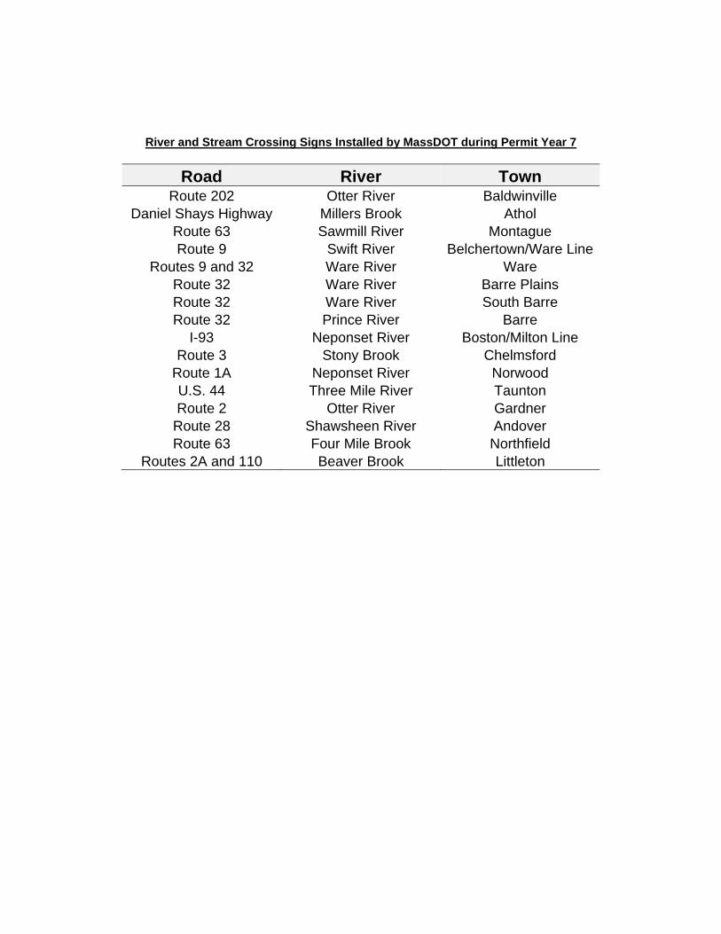
River and Stream Crossing Signs Installed by MassDOT during Permit Year 7
Road River Town Route 202 Otter River Baldwinville
Daniel Shays Highway Millers Brook Athol Route 63 Sawmill River Montague Route 9 Swift River Belchertown/Ware Line
Routes 9 and 32 Ware River Ware Route 32 Ware River Barre Plains Route 32 Ware River South Barre Route 32 Prince River Barre
I-93 Neponset River Boston/Milton Line Route 3 Stony Brook Chelmsford
Route 1A Neponset River Norwood U.S. 44 Three Mile River Taunton Route 2 Otter River Gardner
Route 28 Shawsheen River Andover Route 63 Four Mile Brook Northfield
Routes 2A and 110 Beaver Brook Littleton

NPDES Storm Water Management Plan Annual Report – Permit Year 7
Appendix B: Design Public Hearings Table
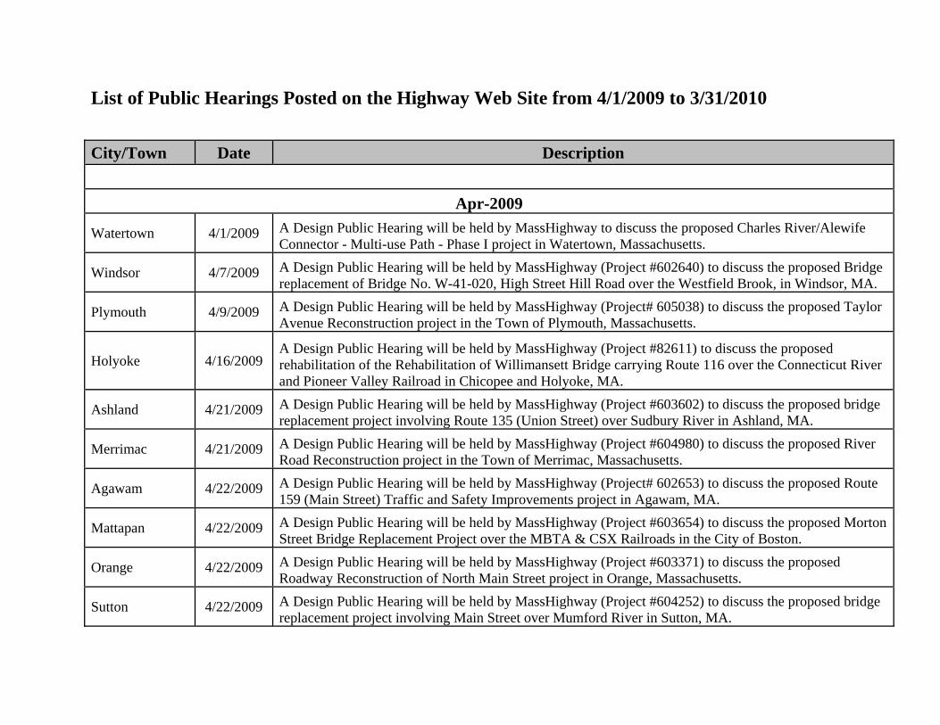
List of Public Hearings Posted on the Highway Web Site from 4/1/2009 to 3/31/2010
City/Town Date Description
Apr-2009
Watertown 4/1/2009 A Design Public Hearing will be held by MassHighway to discuss the proposed Charles River/Alewife Connector - Multi-use Path - Phase I project in Watertown, Massachusetts.
Windsor 4/7/2009 A Design Public Hearing will be held by MassHighway (Project #602640) to discuss the proposed Bridge replacement of Bridge No. W-41-020, High Street Hill Road over the Westfield Brook, in Windsor, MA.
Plymouth 4/9/2009 A Design Public Hearing will be held by MassHighway (Project# 605038) to discuss the proposed Taylor Avenue Reconstruction project in the Town of Plymouth, Massachusetts.
Holyoke 4/16/2009 A Design Public Hearing will be held by MassHighway (Project #82611) to discuss the proposed rehabilitation of the Rehabilitation of Willimansett Bridge carrying Route 116 over the Connecticut River and Pioneer Valley Railroad in Chicopee and Holyoke, MA.
Ashland 4/21/2009 A Design Public Hearing will be held by MassHighway (Project #603602) to discuss the proposed bridge replacement project involving Route 135 (Union Street) over Sudbury River in Ashland, MA.
Merrimac 4/21/2009 A Design Public Hearing will be held by MassHighway (Project #604980) to discuss the proposed River Road Reconstruction project in the Town of Merrimac, Massachusetts.
Agawam 4/22/2009 A Design Public Hearing will be held by MassHighway (Project# 602653) to discuss the proposed Route 159 (Main Street) Traffic and Safety Improvements project in Agawam, MA.
Mattapan 4/22/2009 A Design Public Hearing will be held by MassHighway (Project #603654) to discuss the proposed Morton Street Bridge Replacement Project over the MBTA & CSX Railroads in the City of Boston.
Orange 4/22/2009 A Design Public Hearing will be held by MassHighway (Project #603371) to discuss the proposed Roadway Reconstruction of North Main Street project in Orange, Massachusetts.
Sutton 4/22/2009 A Design Public Hearing will be held by MassHighway (Project #604252) to discuss the proposed bridge replacement project involving Main Street over Mumford River in Sutton, MA.
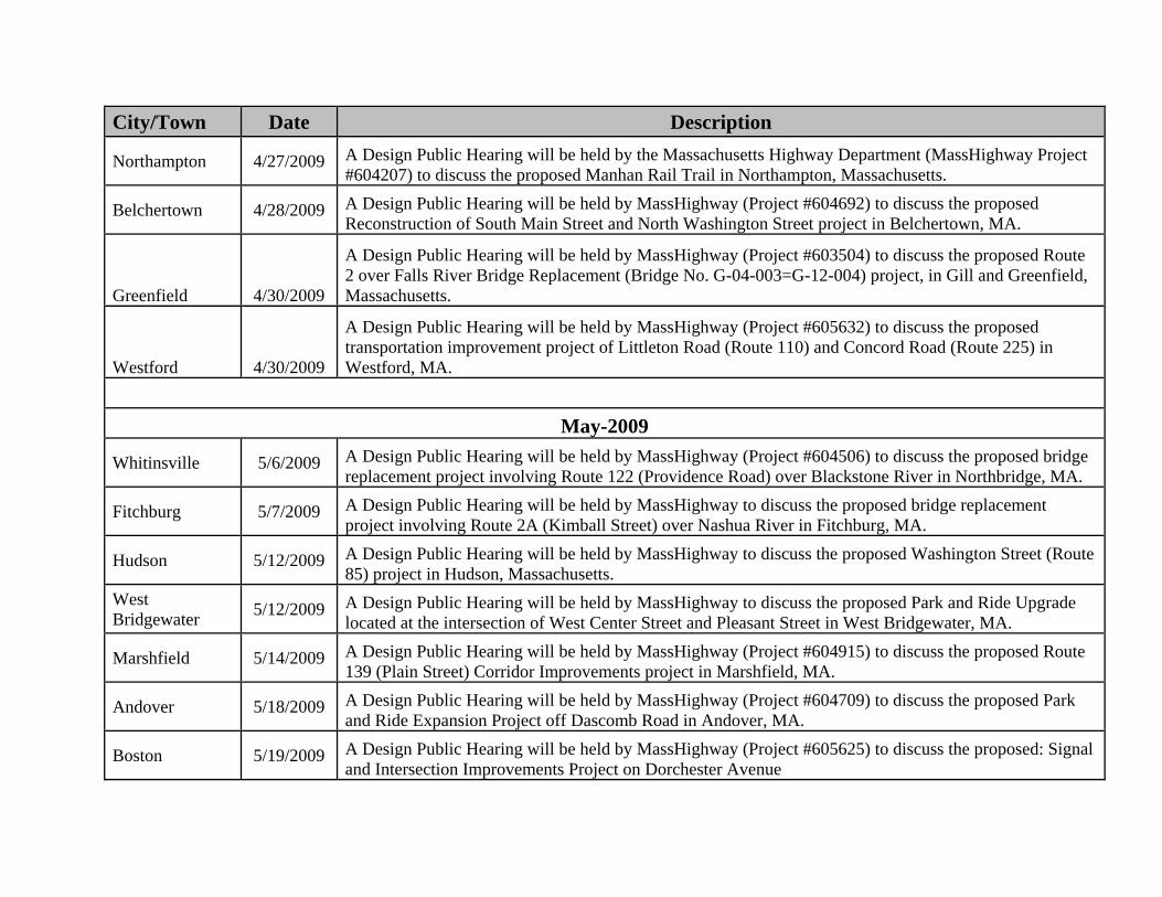
City/Town Date Description
Northampton 4/27/2009 A Design Public Hearing will be held by the Massachusetts Highway Department (MassHighway Project #604207) to discuss the proposed Manhan Rail Trail in Northampton, Massachusetts.
Belchertown 4/28/2009 A Design Public Hearing will be held by MassHighway (Project #604692) to discuss the proposed Reconstruction of South Main Street and North Washington Street project in Belchertown, MA.
Greenfield 4/30/2009
A Design Public Hearing will be held by MassHighway (Project #603504) to discuss the proposed Route 2 over Falls River Bridge Replacement (Bridge No. G-04-003=G-12-004) project, in Gill and Greenfield, Massachusetts.
Westford 4/30/2009
A Design Public Hearing will be held by MassHighway (Project #605632) to discuss the proposed transportation improvement project of Littleton Road (Route 110) and Concord Road (Route 225) in Westford, MA.
May-2009
Whitinsville 5/6/2009 A Design Public Hearing will be held by MassHighway (Project #604506) to discuss the proposed bridge replacement project involving Route 122 (Providence Road) over Blackstone River in Northbridge, MA.
Fitchburg 5/7/2009 A Design Public Hearing will be held by MassHighway to discuss the proposed bridge replacement project involving Route 2A (Kimball Street) over Nashua River in Fitchburg, MA.
Hudson 5/12/2009 A Design Public Hearing will be held by MassHighway to discuss the proposed Washington Street (Route 85) project in Hudson, Massachusetts.
West Bridgewater
5/12/2009 A Design Public Hearing will be held by MassHighway to discuss the proposed Park and Ride Upgrade located at the intersection of West Center Street and Pleasant Street in West Bridgewater, MA.
Marshfield 5/14/2009 A Design Public Hearing will be held by MassHighway (Project #604915) to discuss the proposed Route 139 (Plain Street) Corridor Improvements project in Marshfield, MA.
Andover 5/18/2009 A Design Public Hearing will be held by MassHighway (Project #604709) to discuss the proposed Park and Ride Expansion Project off Dascomb Road in Andover, MA.
Boston 5/19/2009 A Design Public Hearing will be held by MassHighway (Project #605625) to discuss the proposed: Signal and Intersection Improvements Project on Dorchester Avenue
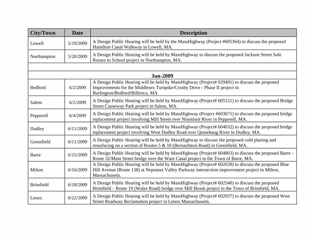
City/Town Date Description
Lowell 5/19/2009 A Design Public Hearing will be held by the MassHighway (Project #605364) to discuss the proposed Hamilton Canal Walkway in Lowell, MA.
Northampton 5/20/2009 A Design Public Hearing will be held by MassHighway to discuss the proposed Jackson Street Safe Routes to School project in Northampton, MA.
Jun-2009
Bedford 6/2/2009 A Design Public Hearing will be held by MassHighway (Project# 029491) to discuss the proposed Improvements for the Middlesex Turnpike/Crosby Drive - Phase II project in Burlington/Bedford/Billerica, MA
Salem 6/2/2009 A Design Public Hearing will be held by MassHighway (Project# 605121) to discuss the proposed Bridge Street Causeway Park project in Salem, MA.
Pepperell 6/4/2009 A Design Public Hearing will be held by MassHighway (Project #603671) to discuss the proposed bridge replacement project involving Mill Street over Nissitissit River in Pepperell, MA.
Dudley 6/11/2009 A Design Public Hearing will be held by MassHighway (Project# 604032) to discuss the proposed bridge replacement project involving West Dudley Road over Quinebaug River in Dudley, MA.
Greenfield 6/11/2009 A Design Public Hearing will be held by MassHighway to discuss the proposed cold planing and resurfacing on a section of Routes 5 & 10 (Bernardston Road) in Greenfield, MA.
Barre 6/15/2009 A Design Public Hearing will be held by MassHighway (Project# 604803) to discuss the proposed Barre - Route 32/Main Street bridge over the Ware Canal project in the Town of Barre, MA.
Milton 6/16/2009 A Design Public Hearing will be held by MassHighway (Project# 602639) to discuss the proposed Blue Hill Avenue (Route 138) at Neponset Valley Parkway intersection improvement project in Milton, Massachusetts.
Brimfield 6/18/2009 A Design Public Hearing will be held by MassHighway (Project# 602540) to discuss the proposed Brimfield – Route 19 (Wales Road) bridge over Mill Brook project in the Town of Brimfield, MA.
Lenox 6/22/2009 A Design Public Hearing will be held by MassHighway (Project# 602937) to discuss the proposed West Street Roadway Reclamation project in Lenox Massachusetts.
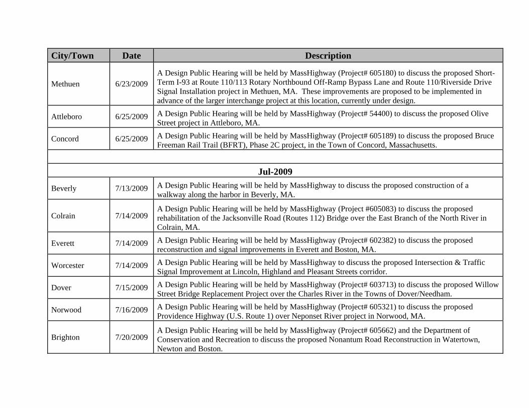
City/Town Date Description
Methuen 6/23/2009 A Design Public Hearing will be held by MassHighway (Project# 605180) to discuss the proposed Short-Term I-93 at Route 110/113 Rotary Northbound Off-Ramp Bypass Lane and Route 110/Riverside Drive Signal Installation project in Methuen, MA. These improvements are proposed to be implemented in advance of the larger interchange project at this location, currently under design.
Attleboro 6/25/2009 A Design Public Hearing will be held by MassHighway (Project# 54400) to discuss the proposed Olive Street project in Attleboro, MA.
Concord 6/25/2009 A Design Public Hearing will be held by MassHighway (Project# 605189) to discuss the proposed Bruce Freeman Rail Trail (BFRT), Phase 2C project, in the Town of Concord, Massachusetts.
Jul-2009
Beverly 7/13/2009 A Design Public Hearing will be held by MassHighway to discuss the proposed construction of a walkway along the harbor in Beverly, MA.
Colrain 7/14/2009 A Design Public Hearing will be held by MassHighway (Project #605083) to discuss the proposed rehabilitation of the Jacksonville Road (Routes 112) Bridge over the East Branch of the North River in Colrain, MA.
Everett 7/14/2009 A Design Public Hearing will be held by MassHighway (Project# 602382) to discuss the proposed reconstruction and signal improvements in Everett and Boston, MA.
Worcester 7/14/2009 A Design Public Hearing will be held by MassHighway to discuss the proposed Intersection & Traffic Signal Improvement at Lincoln, Highland and Pleasant Streets corridor.
Dover 7/15/2009 A Design Public Hearing will be held by MassHighway (Project# 603713) to discuss the proposed Willow Street Bridge Replacement Project over the Charles River in the Towns of Dover/Needham.
Norwood 7/16/2009 A Design Public Hearing will be held by MassHighway (Project# 605321) to discuss the proposed Providence Highway (U.S. Route 1) over Neponset River project in Norwood, MA.
Brighton 7/20/2009 A Design Public Hearing will be held by MassHighway (Project# 605662) and the Department of Conservation and Recreation to discuss the proposed Nonantum Road Reconstruction in Watertown, Newton and Boston.

City/Town Date Description
Somerville 7/23/2009 A Design Public Hearing will be held by MassHighway to discuss the Assembly Square Access Improvement Project in the City of Somerville, MA.
Southampton 7/28/2009 A Design Public Hearing will be held by MassHighway (Project# 604738) to discuss the proposed Glendale Road Reconstruction project in Southampton, MA.
Woburn 7/29/2009 A Design Public Hearing will be held by Massachusetts Highway Department (Project #603008) to discuss the proposed bridge replacement project in Woburn, MA on Salem Street, Bridge No. W-43-003 over the M.B.T.A.
Aug-2009
Freetown 8/5/2009 A Design Public Hearing will be held by MassHighway (Project #605731) to discuss the proposed County Road, Chace Road and Mason Road Roundabout project in Freetown, MA.
Oxford 8/11/2009 A Design Public Hearing will be held by MassHighway to discuss the proposed Traffic Signal Construction project in Oxford, MA.
Wareham 8/12/2009 A Design Public Hearing will be held by MassHighway (Project #603670) to discuss the proposed Bourne/Wareham (William Dalton Memorial Bridge) bridge replacement project in the municipalities of Bourne and Wareham MA.
Buckland 8/17/2009 A Design Public Hearing will be held by MassHighway (Project #604268) to discuss the proposed reconstruction and improvements of State Street in Buckland, MA.
Salem 8/17/2009 A Design Public Hearing will be held by MassHighway (Project #601017) to discuss the proposed Reconstruction of Bridge Street project in Salem, MA.
Sterling 8/20/2009 A Design Public Hearing will be held by MassHighway to discuss the proposed bridge replacement project involving Route 62 (Princeton Road) over the Stillwater River in Sterling, MA.
New Bedford 8/26/2009 A Design Public Hearing will be held by MassHighway to discuss the proposed Route 18-JFK Highway Access Improvements in New Bedford, MA.
Southampton 8/26/2009 A Design Public Hearing will be held by MassHighway (Project #604653) to discuss the proposed Reconstruction of East Street project in Southampton, MA.
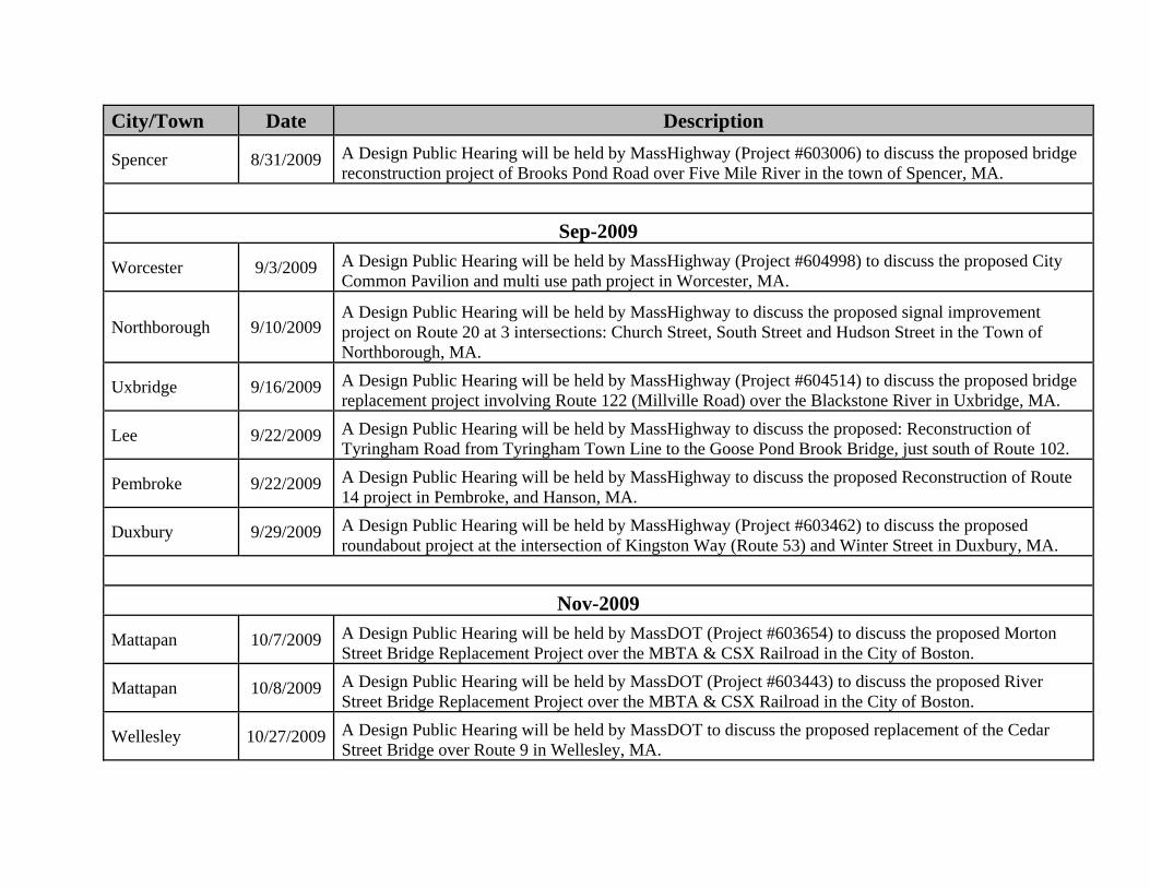
City/Town Date Description
Spencer 8/31/2009 A Design Public Hearing will be held by MassHighway (Project #603006) to discuss the proposed bridge reconstruction project of Brooks Pond Road over Five Mile River in the town of Spencer, MA.
Sep-2009
Worcester 9/3/2009 A Design Public Hearing will be held by MassHighway (Project #604998) to discuss the proposed City Common Pavilion and multi use path project in Worcester, MA.
Northborough 9/10/2009 A Design Public Hearing will be held by MassHighway to discuss the proposed signal improvement project on Route 20 at 3 intersections: Church Street, South Street and Hudson Street in the Town of Northborough, MA.
Uxbridge 9/16/2009 A Design Public Hearing will be held by MassHighway (Project #604514) to discuss the proposed bridge replacement project involving Route 122 (Millville Road) over the Blackstone River in Uxbridge, MA.
Lee 9/22/2009 A Design Public Hearing will be held by MassHighway to discuss the proposed: Reconstruction of Tyringham Road from Tyringham Town Line to the Goose Pond Brook Bridge, just south of Route 102.
Pembroke 9/22/2009 A Design Public Hearing will be held by MassHighway to discuss the proposed Reconstruction of Route 14 project in Pembroke, and Hanson, MA.
Duxbury 9/29/2009 A Design Public Hearing will be held by MassHighway (Project #603462) to discuss the proposed roundabout project at the intersection of Kingston Way (Route 53) and Winter Street in Duxbury, MA.
Nov-2009
Mattapan 10/7/2009 A Design Public Hearing will be held by MassDOT (Project #603654) to discuss the proposed Morton Street Bridge Replacement Project over the MBTA & CSX Railroad in the City of Boston.
Mattapan 10/8/2009 A Design Public Hearing will be held by MassDOT (Project #603443) to discuss the proposed River Street Bridge Replacement Project over the MBTA & CSX Railroad in the City of Boston.
Wellesley 10/27/2009 A Design Public Hearing will be held by MassDOT to discuss the proposed replacement of the Cedar Street Bridge over Route 9 in Wellesley, MA.
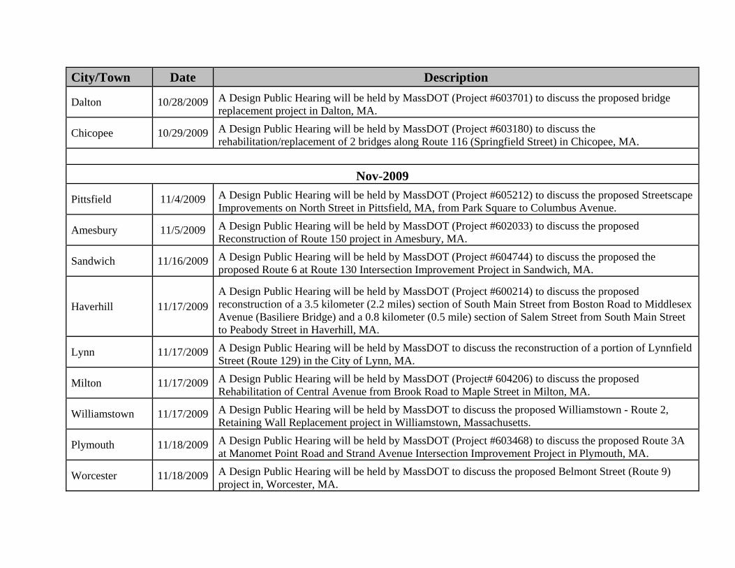
City/Town Date Description
Dalton 10/28/2009 A Design Public Hearing will be held by MassDOT (Project #603701) to discuss the proposed bridge replacement project in Dalton, MA.
Chicopee 10/29/2009 A Design Public Hearing will be held by MassDOT (Project #603180) to discuss the rehabilitation/replacement of 2 bridges along Route 116 (Springfield Street) in Chicopee, MA.
Nov-2009
Pittsfield 11/4/2009 A Design Public Hearing will be held by MassDOT (Project #605212) to discuss the proposed Streetscape Improvements on North Street in Pittsfield, MA, from Park Square to Columbus Avenue.
Amesbury 11/5/2009 A Design Public Hearing will be held by MassDOT (Project #602033) to discuss the proposed Reconstruction of Route 150 project in Amesbury, MA.
Sandwich 11/16/2009 A Design Public Hearing will be held by MassDOT (Project #604744) to discuss the proposed the proposed Route 6 at Route 130 Intersection Improvement Project in Sandwich, MA.
Haverhill 11/17/2009 A Design Public Hearing will be held by MassDOT (Project #600214) to discuss the proposed reconstruction of a 3.5 kilometer (2.2 miles) section of South Main Street from Boston Road to Middlesex Avenue (Basiliere Bridge) and a 0.8 kilometer (0.5 mile) section of Salem Street from South Main Street to Peabody Street in Haverhill, MA.
Lynn 11/17/2009 A Design Public Hearing will be held by MassDOT to discuss the reconstruction of a portion of Lynnfield Street (Route 129) in the City of Lynn, MA.
Milton 11/17/2009 A Design Public Hearing will be held by MassDOT (Project# 604206) to discuss the proposed Rehabilitation of Central Avenue from Brook Road to Maple Street in Milton, MA.
Williamstown 11/17/2009 A Design Public Hearing will be held by MassDOT to discuss the proposed Williamstown - Route 2, Retaining Wall Replacement project in Williamstown, Massachusetts.
Plymouth 11/18/2009 A Design Public Hearing will be held by MassDOT (Project #603468) to discuss the proposed Route 3A at Manomet Point Road and Strand Avenue Intersection Improvement Project in Plymouth, MA.
Worcester 11/18/2009 A Design Public Hearing will be held by MassDOT to discuss the proposed Belmont Street (Route 9) project in, Worcester, MA.
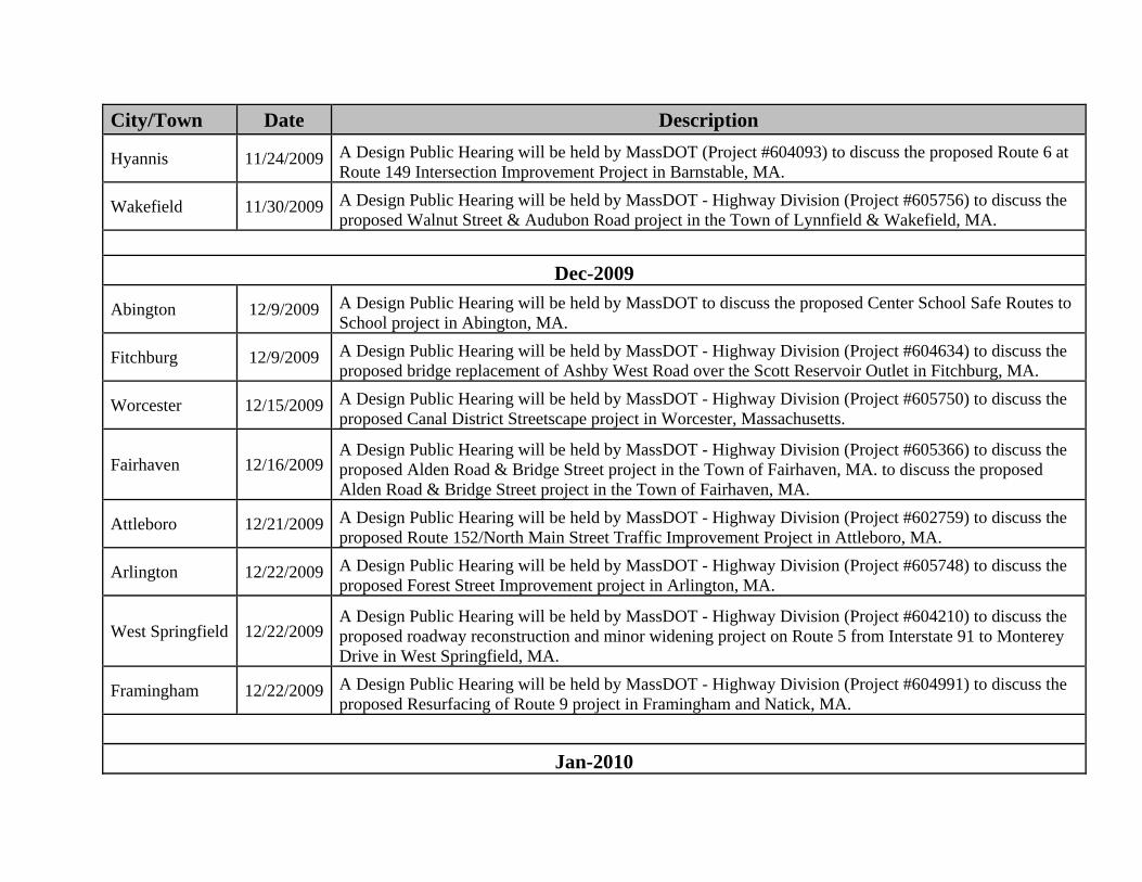
City/Town Date Description
Hyannis 11/24/2009 A Design Public Hearing will be held by MassDOT (Project #604093) to discuss the proposed Route 6 at Route 149 Intersection Improvement Project in Barnstable, MA.
Wakefield 11/30/2009 A Design Public Hearing will be held by MassDOT - Highway Division (Project #605756) to discuss the proposed Walnut Street & Audubon Road project in the Town of Lynnfield & Wakefield, MA.
Dec-2009
Abington 12/9/2009 A Design Public Hearing will be held by MassDOT to discuss the proposed Center School Safe Routes to School project in Abington, MA.
Fitchburg 12/9/2009 A Design Public Hearing will be held by MassDOT - Highway Division (Project #604634) to discuss the proposed bridge replacement of Ashby West Road over the Scott Reservoir Outlet in Fitchburg, MA.
Worcester 12/15/2009 A Design Public Hearing will be held by MassDOT - Highway Division (Project #605750) to discuss the proposed Canal District Streetscape project in Worcester, Massachusetts.
Fairhaven 12/16/2009 A Design Public Hearing will be held by MassDOT - Highway Division (Project #605366) to discuss the proposed Alden Road & Bridge Street project in the Town of Fairhaven, MA. to discuss the proposed Alden Road & Bridge Street project in the Town of Fairhaven, MA.
Attleboro 12/21/2009 A Design Public Hearing will be held by MassDOT - Highway Division (Project #602759) to discuss the proposed Route 152/North Main Street Traffic Improvement Project in Attleboro, MA.
Arlington 12/22/2009 A Design Public Hearing will be held by MassDOT - Highway Division (Project #605748) to discuss the proposed Forest Street Improvement project in Arlington, MA.
West Springfield 12/22/2009 A Design Public Hearing will be held by MassDOT - Highway Division (Project #604210) to discuss the proposed roadway reconstruction and minor widening project on Route 5 from Interstate 91 to Monterey Drive in West Springfield, MA.
Framingham 12/22/2009 A Design Public Hearing will be held by MassDOT - Highway Division (Project #604991) to discuss the proposed Resurfacing of Route 9 project in Framingham and Natick, MA.
Jan-2010
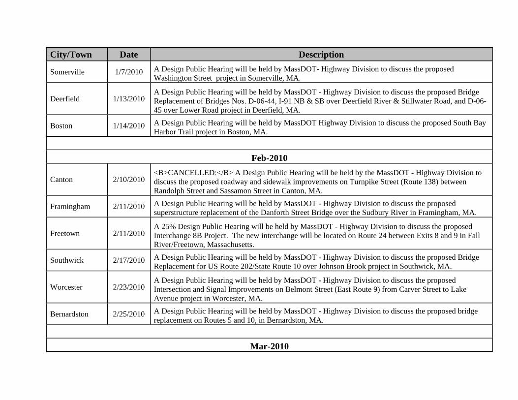
City/Town Date Description
Somerville 1/7/2010 A Design Public Hearing will be held by MassDOT- Highway Division to discuss the proposed Washington Street project in Somerville, MA.
Deerfield 1/13/2010 A Design Public Hearing will be held by MassDOT - Highway Division to discuss the proposed Bridge Replacement of Bridges Nos. D-06-44, I-91 NB & SB over Deerfield River & Stillwater Road, and D-06-45 over Lower Road project in Deerfield, MA.
Boston 1/14/2010 A Design Public Hearing will be held by MassDOT Highway Division to discuss the proposed South Bay Harbor Trail project in Boston, MA.
Feb-2010
Canton 2/10/2010 <B>CANCELLED:</B> A Design Public Hearing will be held by the MassDOT - Highway Division to discuss the proposed roadway and sidewalk improvements on Turnpike Street (Route 138) between Randolph Street and Sassamon Street in Canton, MA.
Framingham 2/11/2010 A Design Public Hearing will be held by MassDOT - Highway Division to discuss the proposed superstructure replacement of the Danforth Street Bridge over the Sudbury River in Framingham, MA.
Freetown 2/11/2010 A 25% Design Public Hearing will be held by MassDOT - Highway Division to discuss the proposed Interchange 8B Project. The new interchange will be located on Route 24 between Exits 8 and 9 in Fall River/Freetown, Massachusetts.
Southwick 2/17/2010 A Design Public Hearing will be held by MassDOT - Highway Division to discuss the proposed Bridge Replacement for US Route 202/State Route 10 over Johnson Brook project in Southwick, MA.
Worcester 2/23/2010 A Design Public Hearing will be held by MassDOT - Highway Division to discuss the proposed Intersection and Signal Improvements on Belmont Street (East Route 9) from Carver Street to Lake Avenue project in Worcester, MA.
Bernardston 2/25/2010 A Design Public Hearing will be held by MassDOT - Highway Division to discuss the proposed bridge replacement on Routes 5 and 10, in Bernardston, MA.
Mar-2010
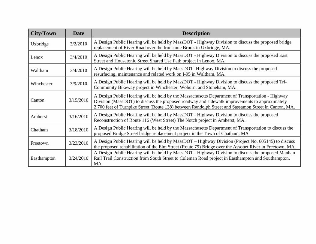
City/Town Date Description
Uxbridge 3/2/2010 A Design Public Hearing will be held by MassDOT - Highway Division to discuss the proposed bridge replacement of River Road over the Ironstone Brook in Uxbridge, MA.
Lenox 3/4/2010 A Design Public Hearing will be held by MassDOT - Highway Division to discuss the proposed East Street and Housatonic Street Shared Use Path project in Lenox, MA.
Waltham 3/4/2010 A Design Public Hearing will be held by MassDOT- Highway Division to discuss the proposed resurfacing, maintenance and related work on I-95 in Waltham, MA.
Winchester 3/9/2010 A Design Public Hearing will be held by MassDOT - Highway Division to discuss the proposed Tri- Community Bikeway project in Winchester, Woburn, and Stoneham, MA.
Canton 3/15/2010 A Design Public Hearing will be held by the Massachusetts Department of Transportation - Highway Division (MassDOT) to discuss the proposed roadway and sidewalk improvements to approximately 2,700 feet of Turnpike Street (Route 138) between Randolph Street and Sassamon Street in Canton, MA.
Amherst 3/16/2010 A Design Public Hearing will be held by MassDOT - Highway Division to discuss the proposed Reconstruction of Route 116 (West Street) The Notch project in Amherst, MA.
Chatham 3/18/2010 A Design Public Hearing will be held by the Massachusetts Department of Transportation to discuss the proposed Bridge Street bridge replacement project in the Town of Chatham, MA
Freetown 3/23/2010 A Design Public Hearing will be held by MassDOT – Highway Division (Project No. 605145) to discuss the proposed rehabilitation of the Elm Street (Route 79) Bridge over the Assonet River in Freetown, MA.
Easthampton 3/24/2010 A Design Public Hearing will be held by MassDOT - Highway Division to discuss the proposed Manhan Rail Trail Construction from South Street to Coleman Road project in Easthampton and Southampton, MA.

NPDES Storm Water Management Plan Annual Report – Permit Year 7
Appendix C: Permits Issued/Denied/In Process as of Permit Year 7
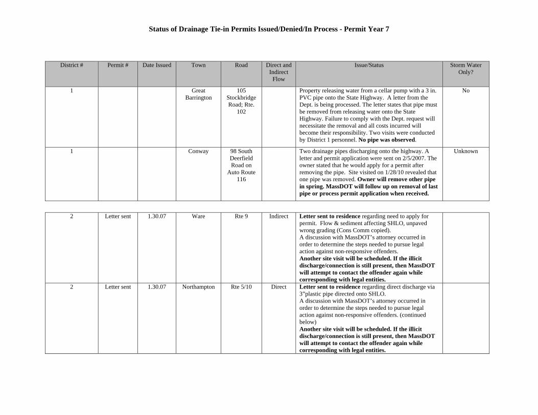
Status of Drainage Tie-in Permits Issued/Denied/In Process - Permit Year 7
District # Permit # Date Issued Town Road Direct and Indirect
Flow
Issue/Status Storm Water Only?
1 Great Barrington
105 Stockbridge Road; Rte.
102
Property releasing water from a cellar pump with a 3 in. PVC pipe onto the State Highway. A letter from the Dept. is being processed. The letter states that pipe must be removed from releasing water onto the State Highway. Failure to comply with the Dept. request will necessitate the removal and all costs incurred will become their responsibility. Two visits were conducted by District 1 personnel. No pipe was observed.
No
1 Conway 98 South Deerfield Road on
Auto Route 116
Two drainage pipes discharging onto the highway. A letter and permit application were sent on 2/5/2007. The owner stated that he would apply for a permit after removing the pipe. Site visited on 1/28/10 revealed that one pipe was removed. Owner will remove other pipe in spring. MassDOT will follow up on removal of last pipe or process permit application when received.
Unknown
2 Letter sent 1.30.07 Ware Rte 9 Indirect Letter sent to residence regarding need to apply for permit. Flow & sediment affecting SHLO, unpaved wrong grading (Cons Comm copied). A discussion with MassDOT’s attorney occurred in order to determine the steps needed to pursue legal action against non-responsive offenders. Another site visit will be scheduled. If the illicit discharge/connection is still present, then MassDOT will attempt to contact the offender again while corresponding with legal entities.
2 Letter sent 1.30.07 Northampton Rte 5/10 Direct Letter sent to residence regarding direct discharge via 3”plastic pipe directed onto SHLO. A discussion with MassDOT’s attorney occurred in order to determine the steps needed to pursue legal action against non-responsive offenders. (continued below) Another site visit will be scheduled. If the illicit discharge/connection is still present, then MassDOT will attempt to contact the offender again while corresponding with legal entities.
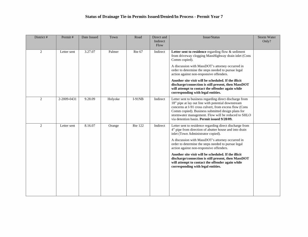
Status of Drainage Tie-in Permits Issued/Denied/In Process - Permit Year 7
District # Permit # Date Issued Town Road Direct and Indirect
Flow
Issue/Status Storm Water Only?
2 Letter sent 3.27.07 Palmer Rte 67 Indirect Letter sent to residence regarding flow & sediment from driveway clogging MassHighway drain inlet (Cons Comm copied).
A discussion with MassDOT’s attorney occurred in order to determine the steps needed to pursue legal action against non-responsive offenders.
Another site visit will be scheduled. If the illicit discharge/connection is still present, then MassDOT will attempt to contact the offender again while corresponding with legal entities.
2 2-2009-0431 9.28.09 Holyoke I-91NB Indirect Letter sent to business regarding direct discharge from 18” pipe at lay out line with potential downstream concerns at I-91 cross culvert, from excess flow (Cons Comm copied). Business submitted design plans for stormwater management. Flow will be reduced to SHLO via detention basin. Permit issued 9/28/09.
2 Letter sent 8.16.07 Orange Rte 122 Indirect Letter sent to residence regarding direct discharge from 4” pipe from direction of abutter house and into drain inlet (Town Administrator copied).
A discussion with MassDOT’s attorney occurred in order to determine the steps needed to pursue legal action against non-responsive offenders.
Another site visit will be scheduled. If the illicit discharge/connection is still present, then MassDOT will attempt to contact the offender again while corresponding with legal entities.
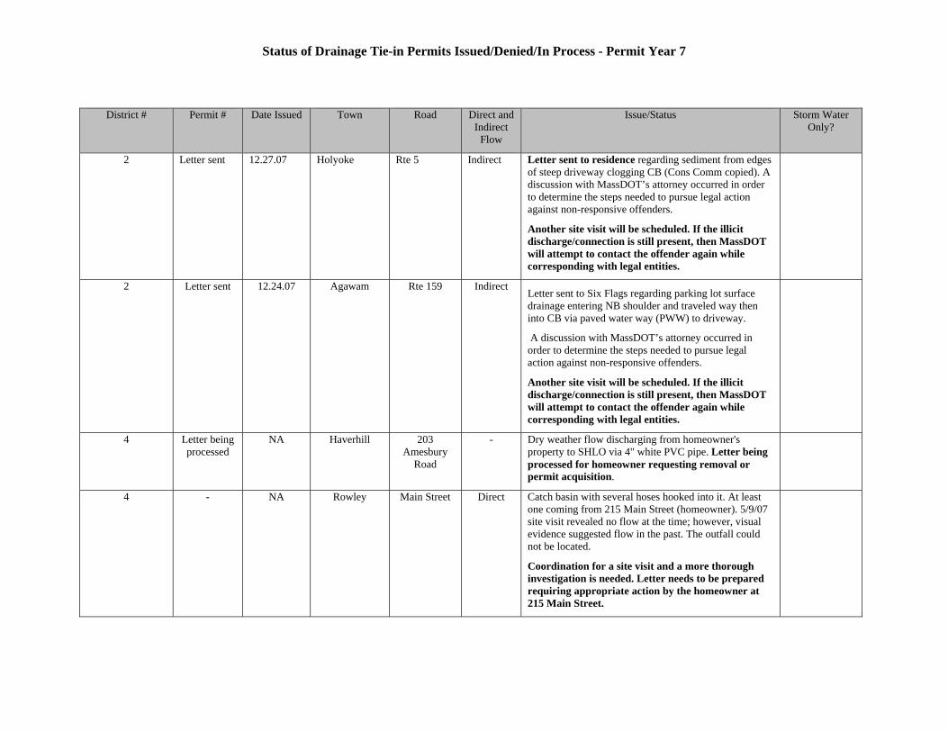
Status of Drainage Tie-in Permits Issued/Denied/In Process - Permit Year 7
District # Permit # Date Issued Town Road Direct and Indirect
Flow
Issue/Status Storm Water Only?
2 Letter sent 12.27.07 Holyoke Rte 5 Indirect Letter sent to residence regarding sediment from edges of steep driveway clogging CB (Cons Comm copied). A discussion with MassDOT’s attorney occurred in order to determine the steps needed to pursue legal action against non-responsive offenders.
Another site visit will be scheduled. If the illicit discharge/connection is still present, then MassDOT will attempt to contact the offender again while corresponding with legal entities.
2 Letter sent 12.24.07 Agawam Rte 159 Indirect Letter sent to Six Flags regarding parking lot surface drainage entering NB shoulder and traveled way then into CB via paved water way (PWW) to driveway.
A discussion with MassDOT’s attorney occurred in order to determine the steps needed to pursue legal action against non-responsive offenders.
Another site visit will be scheduled. If the illicit discharge/connection is still present, then MassDOT will attempt to contact the offender again while corresponding with legal entities.
4 Letter being processed
NA Haverhill 203 Amesbury
Road
- Dry weather flow discharging from homeowner's property to SHLO via 4" white PVC pipe. Letter being processed for homeowner requesting removal or permit acquisition.
4 - NA Rowley Main Street Direct Catch basin with several hoses hooked into it. At least one coming from 215 Main Street (homeowner). 5/9/07 site visit revealed no flow at the time; however, visual evidence suggested flow in the past. The outfall could not be located.
Coordination for a site visit and a more thorough investigation is needed. Letter needs to be prepared requiring appropriate action by the homeowner at 215 Main Street.
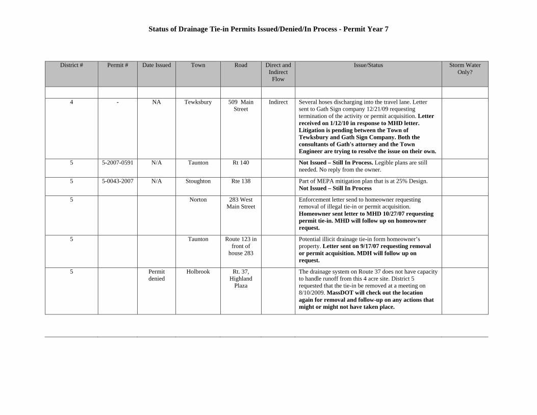
Status of Drainage Tie-in Permits Issued/Denied/In Process - Permit Year 7
District # Permit # Date Issued Town Road Direct and Indirect
Flow
Issue/Status Storm Water Only?
4 - NA Tewksbury 509 Main Street
Indirect Several hoses discharging into the travel lane. Letter sent to Gath Sign company 12/21/09 requesting termination of the activity or permit acquisition. Letter received on 1/12/10 in response to MHD letter. Litigation is pending between the Town of Tewksbury and Gath Sign Company. Both the consultants of Gath's attorney and the Town Engineer are trying to resolve the issue on their own.
5 5-2007-0591 N/A Taunton Rt 140 Not Issued – Still In Process. Legible plans are still needed. No reply from the owner.
5 5-0043-2007 N/A Stoughton Rte 138 Part of MEPA mitigation plan that is at 25% Design. Not Issued – Still In Process
5 Norton 283 West Main Street
Enforcement letter send to homeowner requesting removal of illegal tie-in or permit acquisition. Homeowner sent letter to MHD 10/27/07 requesting permit tie-in. MHD will follow up on homeowner request.
5 Taunton Route 123 in front of
house 283
Potential illicit drainage tie-in form homeowner’s property. Letter sent on 9/17/07 requesting removal or permit acquisition. MDH will follow up on request.
5 Permit denied
Holbrook Rt. 37, Highland
Plaza
The drainage system on Route 37 does not have capacity to handle runoff from this 4 acre site. District 5 requested that the tie-in be removed at a meeting on 8/10/2009. MassDOT will check out the location again for removal and follow-up on any actions that might or might not have taken place.

NPDES Storm Water Management Plan Annual Report – Permit Year 7
Appendix D: Potential Illicit Discharges/Connections as of Permit Year 7
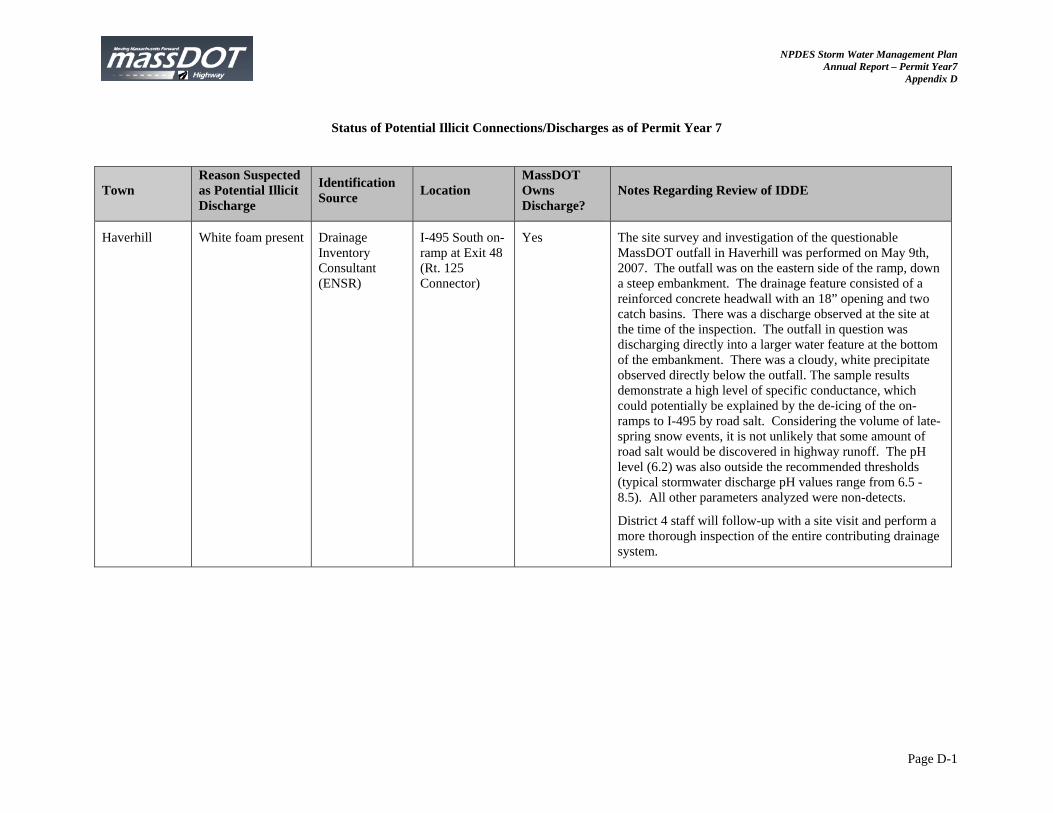
NPDES Storm Water Management Plan Annual Report – Permit Year7
Appendix D
Page D-1
Status of Potential Illicit Connections/Discharges as of Permit Year 7
Town Reason Suspected as Potential Illicit Discharge
Identification Source
Location MassDOT Owns Discharge?
Notes Regarding Review of IDDE
Haverhill White foam present Drainage Inventory Consultant (ENSR)
I-495 South on-ramp at Exit 48 (Rt. 125 Connector)
Yes The site survey and investigation of the questionable MassDOT outfall in Haverhill was performed on May 9th, 2007. The outfall was on the eastern side of the ramp, down a steep embankment. The drainage feature consisted of a reinforced concrete headwall with an 18” opening and two catch basins. There was a discharge observed at the site at the time of the inspection. The outfall in question was discharging directly into a larger water feature at the bottom of the embankment. There was a cloudy, white precipitate observed directly below the outfall. The sample results demonstrate a high level of specific conductance, which could potentially be explained by the de-icing of the on-ramps to I-495 by road salt. Considering the volume of late-spring snow events, it is not unlikely that some amount of road salt would be discovered in highway runoff. The pH level (6.2) was also outside the recommended thresholds (typical stormwater discharge pH values range from 6.5 -8.5). All other parameters analyzed were non-detects.
District 4 staff will follow-up with a site visit and perform a more thorough inspection of the entire contributing drainage system.
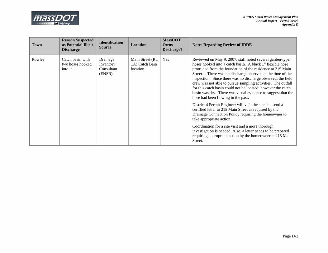
NPDES Storm Water Management Plan Annual Report – Permit Year7
Appendix D
Page D-2
Town Reason Suspected as Potential Illicit Discharge
Identification Source
Location MassDOT Owns Discharge?
Notes Regarding Review of IDDE
Rowley Catch basin with two hoses hooked into it
Drainage Inventory Consultant (ENSR)
Main Street (Rt. 1A) Catch Bain location
Yes Reviewed on May 9, 2007, staff noted several garden-type hoses hooked into a catch basin. A black 1” flexible hose protruded from the foundation of the residence at 215 Main Street. . There was no discharge observed at the time of the inspection. Since there was no discharge observed, the field crew was not able to pursue sampling activities. The outfall for this catch basin could not be located; however the catch basin was dry. There was visual evidence to suggest that the hose had been flowing in the past.
District 4 Permit Engineer will visit the site and send a certified letter to 215 Main Street as required by the Drainage Connection Policy requiring the homeowner to take appropriate action.
Coordination for a site visit and a more thorough investigation is needed. Also, a letter needs to be prepared requiring appropriate action by the homeowner at 215 Main Street.
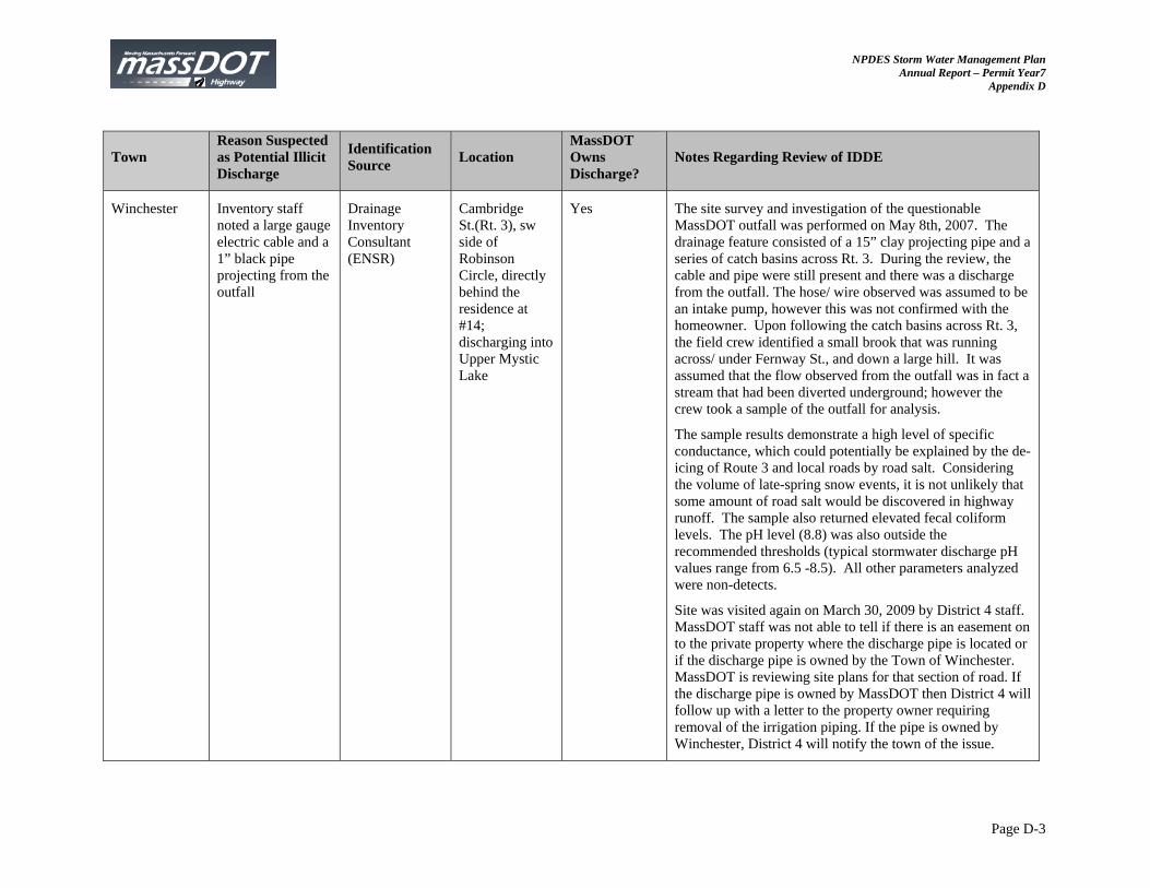
NPDES Storm Water Management Plan Annual Report – Permit Year7
Appendix D
Page D-3
Town Reason Suspected as Potential Illicit Discharge
Identification Source
Location MassDOT Owns Discharge?
Notes Regarding Review of IDDE
Winchester Inventory staff noted a large gauge electric cable and a 1” black pipe projecting from the outfall
Drainage Inventory Consultant (ENSR)
Cambridge St.(Rt. 3), sw side of Robinson Circle, directly behind the residence at #14; discharging into Upper Mystic Lake
Yes The site survey and investigation of the questionable MassDOT outfall was performed on May 8th, 2007. The drainage feature consisted of a 15” clay projecting pipe and a series of catch basins across Rt. 3. During the review, the cable and pipe were still present and there was a discharge from the outfall. The hose/ wire observed was assumed to be an intake pump, however this was not confirmed with the homeowner. Upon following the catch basins across Rt. 3, the field crew identified a small brook that was running across/ under Fernway St., and down a large hill. It was assumed that the flow observed from the outfall was in fact a stream that had been diverted underground; however the crew took a sample of the outfall for analysis.
The sample results demonstrate a high level of specific conductance, which could potentially be explained by the de-icing of Route 3 and local roads by road salt. Considering the volume of late-spring snow events, it is not unlikely that some amount of road salt would be discovered in highway runoff. The sample also returned elevated fecal coliform levels. The pH level (8.8) was also outside the recommended thresholds (typical stormwater discharge pH values range from 6.5 -8.5). All other parameters analyzed were non-detects.
Site was visited again on March 30, 2009 by District 4 staff. MassDOT staff was not able to tell if there is an easement on to the private property where the discharge pipe is located or if the discharge pipe is owned by the Town of Winchester. MassDOT is reviewing site plans for that section of road. If the discharge pipe is owned by MassDOT then District 4 will follow up with a letter to the property owner requiring removal of the irrigation piping. If the pipe is owned by Winchester, District 4 will notify the town of the issue.
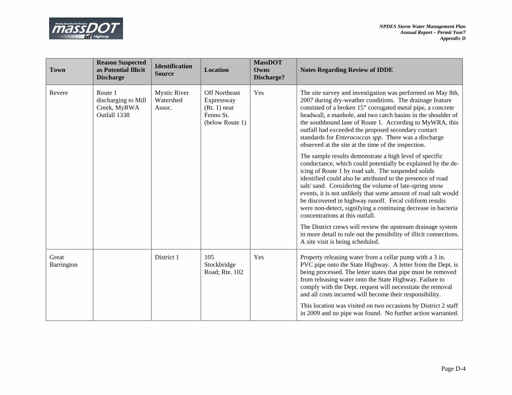
NPDES Storm Water Management Plan Annual Report – Permit Year7
Appendix D
Page D-4
Town Reason Suspected as Potential Illicit Discharge
Identification Source
Location MassDOT Owns Discharge?
Notes Regarding Review of IDDE
Revere Route 1 discharging to Mill Creek, MyRWA Outfall 1338
Mystic River Watershed Assoc.
Off Northeast Expressway (Rt. 1) near Fenno St. (below Route 1)
Yes The site survey and investigation was performed on May 8th, 2007 during dry-weather conditions. The drainage feature consisted of a broken 15” corrugated metal pipe, a concrete headwall, a manhole, and two catch basins in the shoulder of the southbound lane of Route 1. According to MyWRA, this outfall had exceeded the proposed secondary contact standards for Enterococcus spp. There was a discharge observed at the site at the time of the inspection.
The sample results demonstrate a high level of specific conductance, which could potentially be explained by the de-icing of Route 1 by road salt. The suspended solids identified could also be attributed to the presence of road salt/ sand. Considering the volume of late-spring snow events, it is not unlikely that some amount of road salt would be discovered in highway runoff. Fecal coliform results were non-detect, signifying a continuing decrease in bacteria concentrations at this outfall.
The District crews will review the upstream drainage system in more detail to rule out the possibility of illicit connections. A site visit is being scheduled.
Great Barrington
District 1 105 Stockbridge Road; Rte. 102
Yes Property releasing water from a cellar pump with a 3 in. PVC pipe onto the State Highway. A letter from the Dept. is being processed. The letter states that pipe must be removed from releasing water onto the State Highway. Failure to comply with the Dept. request will necessitate the removal and all costs incurred will become their responsibility.
This location was visited on two occasions by District 2 staff in 2009 and no pipe was found. No further action warranted.
NPDES Storm Water Management Plan Annual Report – Permit Year7
Appendix D
Page D-5
Town Reason Suspected as Potential Illicit Discharge
Identification Source
Location MassDOT Owns Discharge?
Notes Regarding Review of IDDE
Ashfield District 1 Yes Underground 3 in. PVC pipe tied into an existing catch basin from homeowners’ property. A letter from the Department is being processed. The letter states that this is an illicit connection and that they are in violation of Chapter 81, Section 21 of Massachusetts General Laws. The connection should be removed and that it is the landowner responsibility to apply for and receive a MassDOT tie in permit.
Investigated by District 1 Staff: The address could not be confirmed; however, no anomalous discharge was observed within the immediate area.
Ware District 2 Route 9 Yes Letter sent to residence regarding need to apply for permit on 1/30/07. Flow & sediment affecting SHLO, unpaved wrong grading (Cons Comm copied).
A discussion with MassDOT’s attorney occurred in order to determine the steps needed to pursue legal action against non-responsive offenders.
Another site visit will be scheduled. If the illicit discharge/connection is still present, then MassDOT will attempt to contact the offender again while corresponding with legal entities.
NPDES Storm Water Management Plan Annual Report – Permit Year7
Appendix D
Page D-6
Town Reason Suspected as Potential Illicit Discharge
Identification Source
Location MassDOT Owns Discharge?
Notes Regarding Review of IDDE
Northampton District 2 Route 5/10 Yes Letter dated 1/30/07 sent to residence regarding direct discharge via 3”plastic pipe directed onto SHLO.
A discussion with MassDOT’s attorney occurred in order to determine the steps needed to pursue legal action against non-responsive offenders.
Another site visit will be scheduled. If the illicit discharge/connection is still present, then MassDOT will attempt to contact the offender again while corresponding with legal entities.
Palmer District 2 Route 67 Yes Letter dated 3/27/07 sent to residence regarding flow & sediment from driveway clogging MassDOT drain inlet (Cons Comm copied).
A discussion with MassDOT’s attorney occurred in order to determine the steps needed to pursue legal action against non-responsive offenders.
Another site visit will be scheduled. If the illicit discharge/connection is still present, then MassDOT will attempt to contact the offender again while corresponding with legal entities.
NPDES Storm Water Management Plan Annual Report – Permit Year7
Appendix D
Page D-7
Town Reason Suspected as Potential Illicit Discharge
Identification Source
Location MassDOT Owns Discharge?
Notes Regarding Review of IDDE
Orange District 2 Rte 122 Yes Letter dated 8/16/07 sent to residence regarding direct discharge from 4” pipe from direction of abutter house and into drain inlet (Town Administrator copied).
A discussion with MassDOT’s attorney occurred in order to determine the steps needed to pursue legal action against non-responsive offenders.
Another site visit will be scheduled. If the illicit discharge/connection is still present, then MassDOT will attempt to contact the offender again while corresponding with legal entities.
Holyoke District 2 Rte 5 Yes Letter dated 12/27/07 sent to residence regarding sediment from edges of steep driveway clogging CB (Cons Comm copied).
A discussion with MassDOT’s attorney occurred in order to determine the steps needed to pursue legal action against non-responsive offenders.
Another site visit will be scheduled. If the illicit discharge/connection is still present, then MassDOT will attempt to contact the offender again while corresponding with legal entities.
NPDES Storm Water Management Plan Annual Report – Permit Year7
Appendix D
Page D-8
Town Reason Suspected as Potential Illicit Discharge
Identification Source
Location MassDOT Owns Discharge?
Notes Regarding Review of IDDE
Agawam District 2 Route 159 Yes Letter dated 12/24/07 sent to Six Flags regarding parking lot surface drainage entering NB shoulder and traveled way then into CB via paved water way (PWW) to driveway.
A discussion with MassDOT’s attorney occurred in order to determine the steps needed to pursue legal action against non-responsive offenders.
Another site visit will be scheduled. If the illicit discharge/connection is still present, then MassDOT will attempt to contact the offender again while corresponding with legal entities.
Taunton Potential illicit drainage tie-in
District 4 Route 123 (West Main Street) in front of house 283
Yes Letter sent to homeowner on September 17, 2007 giving homeowner 90 days to either discontinue the tie-in or apply for a permit to tie-in to the MassDOT drainage system. If homeowner does not respond within the time frame, the matter will be referred to the State Attorney General’s office.
A discussion with MassDOT’s attorney occurred in order to determine the steps needed to pursue legal action against non-responsive offenders.
Another site visit will be scheduled. If the illicit discharge/connection is still present, then MassDOT will attempt to contact the offender again while corresponding with legal entities.
NPDES Storm Water Management Plan Annual Report – Permit Year7
Appendix D
Page D-9
Town Reason Suspected as Potential Illicit Discharge
Identification Source
Location MassDOT Owns Discharge?
Notes Regarding Review of IDDE
Norton District 5 283 West Main Street
Yes MassDOT sent an enforcement letter to the homeowner indicating that the illegal tie-in needed to be removed or the homeowner needed to apply for a permit. Owner sent letter dated 10/27/07 requesting a permit to tie-in to state drainage. MassDOT will send permit application and invite owner to meeting with District 5 to discuss tie-in.
A discussion with MassDOT’s attorney occurred in order to determine the steps needed to pursue legal action against non-responsive offenders.
Another site visit will be scheduled. If the illicit discharge/connection is still present, then MassDOT will attempt to contact the offender again while corresponding with legal entities.
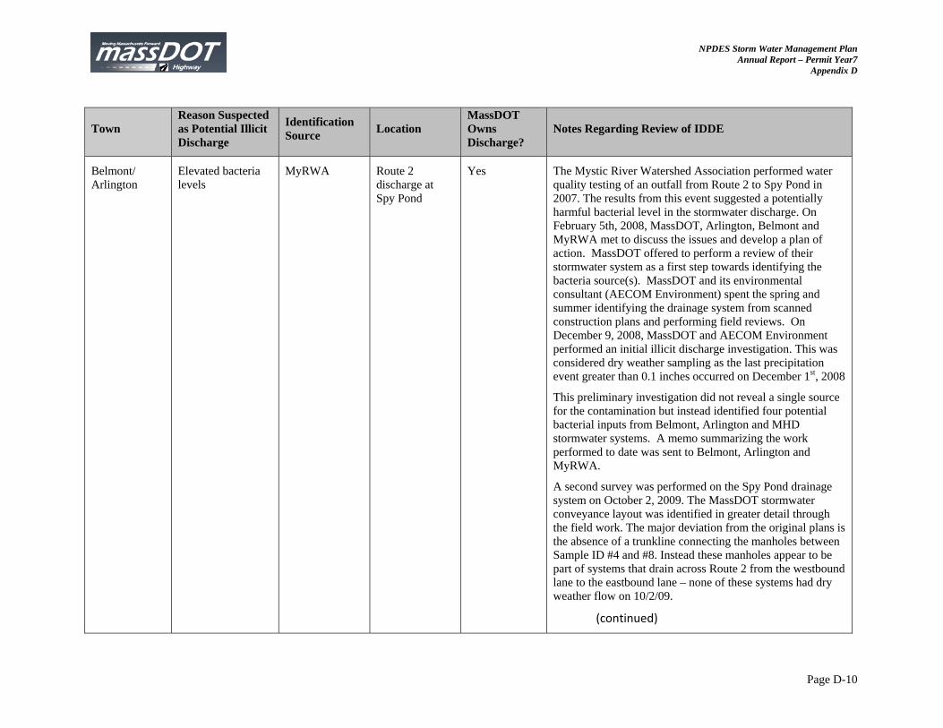
NPDES Storm Water Management Plan Annual Report – Permit Year7
Appendix D
Page D-10
Town Reason Suspected as Potential Illicit Discharge
Identification Source
Location MassDOT Owns Discharge?
Notes Regarding Review of IDDE
Belmont/ Arlington
Elevated bacteria levels
MyRWA Route 2 discharge at Spy Pond
Yes The Mystic River Watershed Association performed water quality testing of an outfall from Route 2 to Spy Pond in 2007. The results from this event suggested a potentially harmful bacterial level in the stormwater discharge. On February 5th, 2008, MassDOT, Arlington, Belmont and MyRWA met to discuss the issues and develop a plan of action. MassDOT offered to perform a review of their stormwater system as a first step towards identifying the bacteria source(s). MassDOT and its environmental consultant (AECOM Environment) spent the spring and summer identifying the drainage system from scanned construction plans and performing field reviews. On December 9, 2008, MassDOT and AECOM Environment performed an initial illicit discharge investigation. This was considered dry weather sampling as the last precipitation event greater than 0.1 inches occurred on December 1st, 2008
This preliminary investigation did not reveal a single source for the contamination but instead identified four potential bacterial inputs from Belmont, Arlington and MHD stormwater systems. A memo summarizing the work performed to date was sent to Belmont, Arlington and MyRWA.
A second survey was performed on the Spy Pond drainage system on October 2, 2009. The MassDOT stormwater conveyance layout was identified in greater detail through the field work. The major deviation from the original plans is the absence of a trunkline connecting the manholes between Sample ID #4 and #8. Instead these manholes appear to be part of systems that drain across Route 2 from the westbound lane to the eastbound lane – none of these systems had dry weather flow on 10/2/09.
(continued)
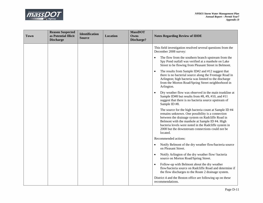
NPDES Storm Water Management Plan Annual Report – Permit Year7
Appendix D
Page D-11
Town Reason Suspected as Potential Illicit Discharge
Identification Source
Location MassDOT Owns Discharge?
Notes Regarding Review of IDDE
This field investigation resolved several questions from the December 2008 survey:
The flow from the southern branch upstream from the Spy Pond outfall was verified at a manhole on Lake Street to be flowing from Pleasant Street in Belmont.
The results from Sample ID#2 and #12 suggest that there is no bacterial source along the Frontage Road in Arlington; high bacteria was limited to the discharge from the Morton Road/Spring Street neighborhood in Arlington.
Dry weather flow was observed in the main trunkline at Sample ID#8 but results from #8, #9, #10, and #11 suggest that there is no bacteria source upstream of Sample ID #8.
The source for the high bacteria count at Sample ID #4 remains unknown. One possibility is a connection between the drainage system on Radcliffe Road in Belmont with the manhole at Sample ID #4. High bacteria levels were noted in the Radcliffe system in 2008 but the downstream connections could not be located.
Recommended actions:
Notify Belmont of the dry weather flow/bacteria source on Pleasant Street.
Notify Arlington of the dry weather flow/ bacteria source on Morton Road/Spring Street.
Follow-up with Belmont about the dry weather flow/bacteria source on Radcliffe Road and determine if the flow discharges to the Route 2 drainage system.
District 4 and the Boston office are following up on these recommendations.
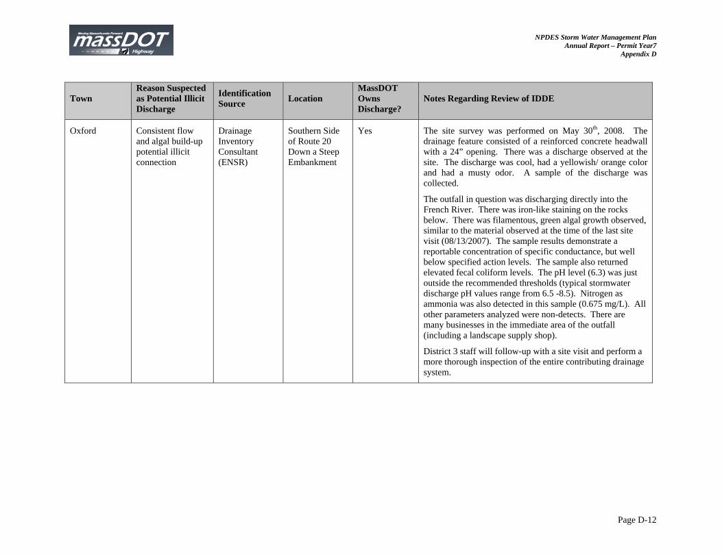
NPDES Storm Water Management Plan Annual Report – Permit Year7
Appendix D
Page D-12
Town Reason Suspected as Potential Illicit Discharge
Identification Source
Location MassDOT Owns Discharge?
Notes Regarding Review of IDDE
Oxford Consistent flow and algal build-up potential illicit connection
Drainage Inventory Consultant (ENSR)
Southern Side of Route 20 Down a Steep Embankment
Yes The site survey was performed on May 30th, 2008. The drainage feature consisted of a reinforced concrete headwall with a 24” opening. There was a discharge observed at the site. The discharge was cool, had a yellowish/ orange color and had a musty odor. A sample of the discharge was collected.
The outfall in question was discharging directly into the French River. There was iron-like staining on the rocks below. There was filamentous, green algal growth observed, similar to the material observed at the time of the last site visit (08/13/2007). The sample results demonstrate a reportable concentration of specific conductance, but well below specified action levels. The sample also returned elevated fecal coliform levels. The pH level (6.3) was just outside the recommended thresholds (typical stormwater discharge pH values range from 6.5 -8.5). Nitrogen as ammonia was also detected in this sample (0.675 mg/L). All other parameters analyzed were non-detects. There are many businesses in the immediate area of the outfall (including a landscape supply shop).
District 3 staff will follow-up with a site visit and perform a more thorough inspection of the entire contributing drainage system.
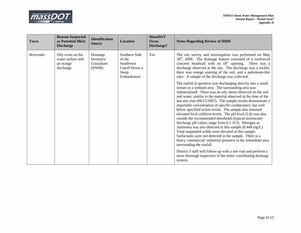
NPDES Storm Water Management Plan Annual Report – Permit Year7
Appendix D
Page D-13
Town Reason Suspected as Potential Illicit Discharge
Identification Source
Location MassDOT Owns Discharge?
Notes Regarding Review of IDDE
Worcester Oily scum on the water surface and an orange discharge
Drainage Inventory Consultant (ENSR)
Southern Side of the Southwest Cutoff Down a Steep Embankment
Yes The site survey and investigation was performed on May 30th, 2008. The drainage feature consisted of a reinforced concrete headwall with an 18” opening. There was a discharge observed at the site. The discharge was a trickle; there was orange staining of the soil, and a petroleum-like odor. A sample of the discharge was collected.
The outfall in question was discharging directly into a small stream in a wetland area. The surrounding area was industrialized. There was an oily sheen observed on the soil and water, similar to the material observed at the time of the last site visit (08/13/2007). The sample results demonstrate a reportable concentration of specific conductance, but well below specified action levels. The sample also returned elevated fecal coliform levels. The pH level (5.9) was also outside the recommended thresholds (typical stormwater discharge pH values range from 6.5 -8.5). Nitrogen as Ammonia was also detected in this sample (0.449 mg/L). Total suspended solids were elevated in this sample. Surfactants were not detected in the sample. There is a heavy commercial/ industrial presence in the immediate area surrounding the outfall.
District 3 staff will follow-up with a site visit and perform a more thorough inspection of the entire contributing drainage system.
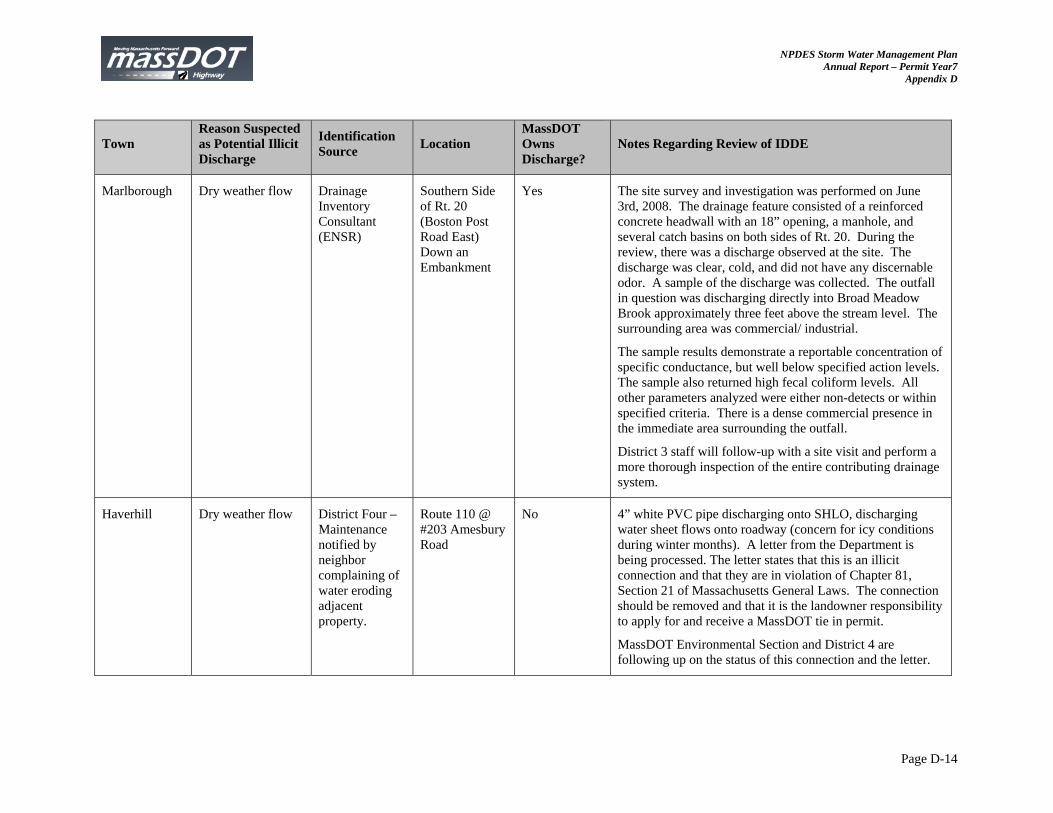
NPDES Storm Water Management Plan Annual Report – Permit Year7
Appendix D
Page D-14
Town Reason Suspected as Potential Illicit Discharge
Identification Source
Location MassDOT Owns Discharge?
Notes Regarding Review of IDDE
Marlborough Dry weather flow Drainage Inventory Consultant (ENSR)
Southern Side of Rt. 20 (Boston Post Road East) Down an Embankment
Yes The site survey and investigation was performed on June 3rd, 2008. The drainage feature consisted of a reinforced concrete headwall with an 18” opening, a manhole, and several catch basins on both sides of Rt. 20. During the review, there was a discharge observed at the site. The discharge was clear, cold, and did not have any discernable odor. A sample of the discharge was collected. The outfall in question was discharging directly into Broad Meadow Brook approximately three feet above the stream level. The surrounding area was commercial/ industrial.
The sample results demonstrate a reportable concentration of specific conductance, but well below specified action levels. The sample also returned high fecal coliform levels. All other parameters analyzed were either non-detects or within specified criteria. There is a dense commercial presence in the immediate area surrounding the outfall.
District 3 staff will follow-up with a site visit and perform a more thorough inspection of the entire contributing drainage system.
Haverhill Dry weather flow District Four – Maintenance notified by neighbor complaining of water eroding adjacent property.
Route 110 @ #203 Amesbury Road
No 4” white PVC pipe discharging onto SHLO, discharging water sheet flows onto roadway (concern for icy conditions during winter months). A letter from the Department is being processed. The letter states that this is an illicit connection and that they are in violation of Chapter 81, Section 21 of Massachusetts General Laws. The connection should be removed and that it is the landowner responsibility to apply for and receive a MassDOT tie in permit.
MassDOT Environmental Section and District 4 are following up on the status of this connection and the letter.
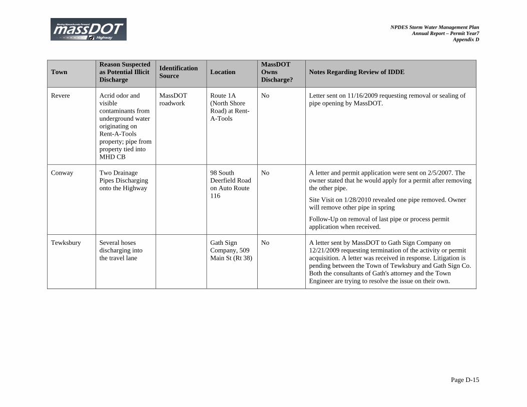
NPDES Storm Water Management Plan Annual Report – Permit Year7
Appendix D
Page D-15
Town Reason Suspected as Potential Illicit Discharge
Identification Source
Location MassDOT Owns Discharge?
Notes Regarding Review of IDDE
Revere Acrid odor and visible contaminants from underground water originating on Rent-A-Tools property; pipe from property tied into MHD CB
MassDOT roadwork
Route 1A (North Shore Road) at Rent-A-Tools
No Letter sent on 11/16/2009 requesting removal or sealing of pipe opening by MassDOT.
Conway Two Drainage Pipes Discharging onto the Highway
98 South Deerfield Road on Auto Route 116
No
A letter and permit application were sent on 2/5/2007. The owner stated that he would apply for a permit after removing the other pipe.
Site Visit on 1/28/2010 revealed one pipe removed. Owner will remove other pipe in spring
Follow-Up on removal of last pipe or process permit application when received.
Tewksbury Several hoses discharging into the travel lane
Gath Sign Company, 509 Main St (Rt 38)
No A letter sent by MassDOT to Gath Sign Company on 12/21/2009 requesting termination of the activity or permit acquisition. A letter was received in response. Litigation is pending between the Town of Tewksbury and Gath Sign Co. Both the consultants of Gath's attorney and the Town Engineer are trying to resolve the issue on their own.
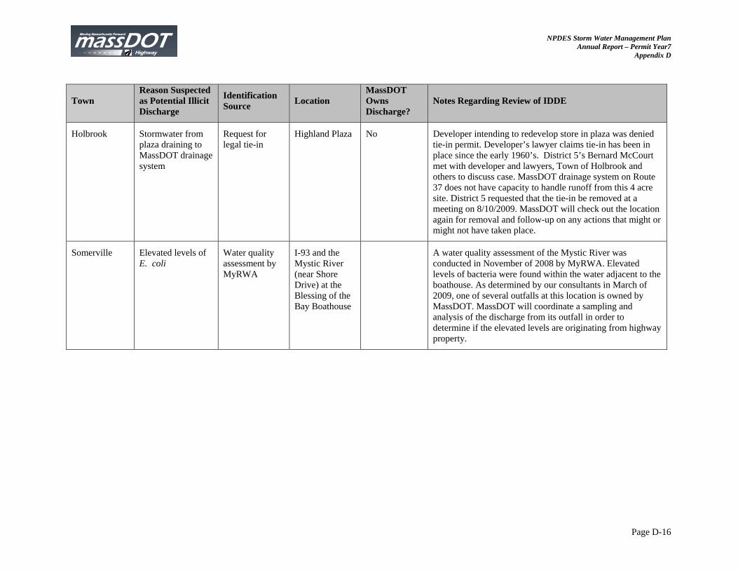
NPDES Storm Water Management Plan Annual Report – Permit Year7
Appendix D
Page D-16
Town Reason Suspected as Potential Illicit Discharge
Identification Source
Location MassDOT Owns Discharge?
Notes Regarding Review of IDDE
Holbrook Stormwater from plaza draining to MassDOT drainage system
Request for legal tie-in
Highland Plaza No Developer intending to redevelop store in plaza was denied tie-in permit. Developer’s lawyer claims tie-in has been in place since the early 1960’s. District 5’s Bernard McCourt met with developer and lawyers, Town of Holbrook and others to discuss case. MassDOT drainage system on Route 37 does not have capacity to handle runoff from this 4 acre site. District 5 requested that the tie-in be removed at a meeting on 8/10/2009. MassDOT will check out the location again for removal and follow-up on any actions that might or might not have taken place.
Somerville Elevated levels of E. coli
Water quality assessment by MyRWA
I-93 and the Mystic River (near Shore Drive) at the Blessing of the Bay Boathouse
A water quality assessment of the Mystic River was conducted in November of 2008 by MyRWA. Elevated levels of bacteria were found within the water adjacent to the boathouse. As determined by our consultants in March of 2009, one of several outfalls at this location is owned by MassDOT. MassDOT will coordinate a sampling and analysis of the discharge from its outfall in order to determine if the elevated levels are originating from highway property.

NPDES Storm Water Management Plan Annual Report – Permit Year 7
Appendix E: Maintenance Schedule Summary
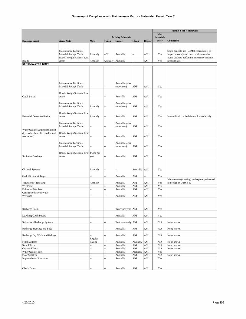
Summary of Compliance with Maintenance Matrix - Statewide Permit Year 7
Mow Sweep Inspect Clean Repair Comments
Maintenance Facilities/ Material Storage Yards Annually ANI Annually -- ANI Yes
Some districts use HazMat coordinators to inspect monthly and then repair as needed.
Roads/ Weigh Stations/ Rest Areas Annually Annually Annually -- ANI Yes
Some districts perform maintenance on an as needed basis.
Maintenance Facilities/ Material Storage Yards -- --
Annually (after snow melt) ANI ANI Yes
Roads/ Weigh Stations/ Rest Areas -- -- Annually ANI ANI Yes
Maintenance Facilities/ Material Storage Yards Annually --
Annually (after snow melt) ANI ANI Yes
Roads/ Weigh Stations/ Rest Areas Annually -- Annually ANI ANI Yes In one district, schedule met for roads only.
Maintenance Facilities/ Material Storage Yards -- --
Annually (after snow melt) ANI ANI Yes
Roads/ Weigh Stations/ Rest Areas -- -- Annually ANI ANI Yes
Maintenance Facilities/ Material Storage Yards -- --
Annually (after snow melt) ANI ANI Yes
Roads/ Weigh Stations/ Rest Areas
Twice per year -- Annually ANI ANI Yes
Channel Systems Annually -- -- Annually ANI Yes
Outlet Sediment Traps -- -- Annually ANI -- Yes
Vegetated Filters Strip Annually -- Annually ANI ANI YesMaintenance (mowing) and repairs performed as needed in District 5.
Wet Pond -- -- Annually ANI ANI YesEnhanced Wet Pond -- -- Annually ANI ANI YesConstructed Storm Water Wetlands -- -- Annually ANI ANI Yes
Recharge Basin -- -- Twice per year ANI ANI Yes
Leaching Catch Basins -- Annually ANI ANI Yes
Subsurface Recharge Systems -- -- Twice annually ANI ANI N/A None known
Recharge Trenches and Beds -- -- Annually ANI ANI N/A None known
Recharge Dry Wells and Galleys -- -- Annually ANI ANI N/A None known
Filter SystemsRegular Raking -- Annually Annually ANI N/A None known
Sand Filters -- -- Annually ANI ANI N/A None knownOrganic Filters -- -- Annually ANI ANI N/A None knownWater Quality Inlet -- -- Annually Annually ANI YesFlow Splitters -- -- Annually ANI ANI N/A None knownImpoundment Structures -- -- Annually ANI ANI Yes
Check Dams -- -- Annually ANI ANI Yes
Water Quality Swales (including dry swales, bio-filter swales, and wet swales)
Sediment Forebays
RoadsSTORMWATER BMPS
Catch Basins
Was Schedule
Met?
Permit Year 7 Statewide
Extended Detention Basins
Drainage Asset Area/ Note
Activity Schedule
4/26/2010 Page E-1
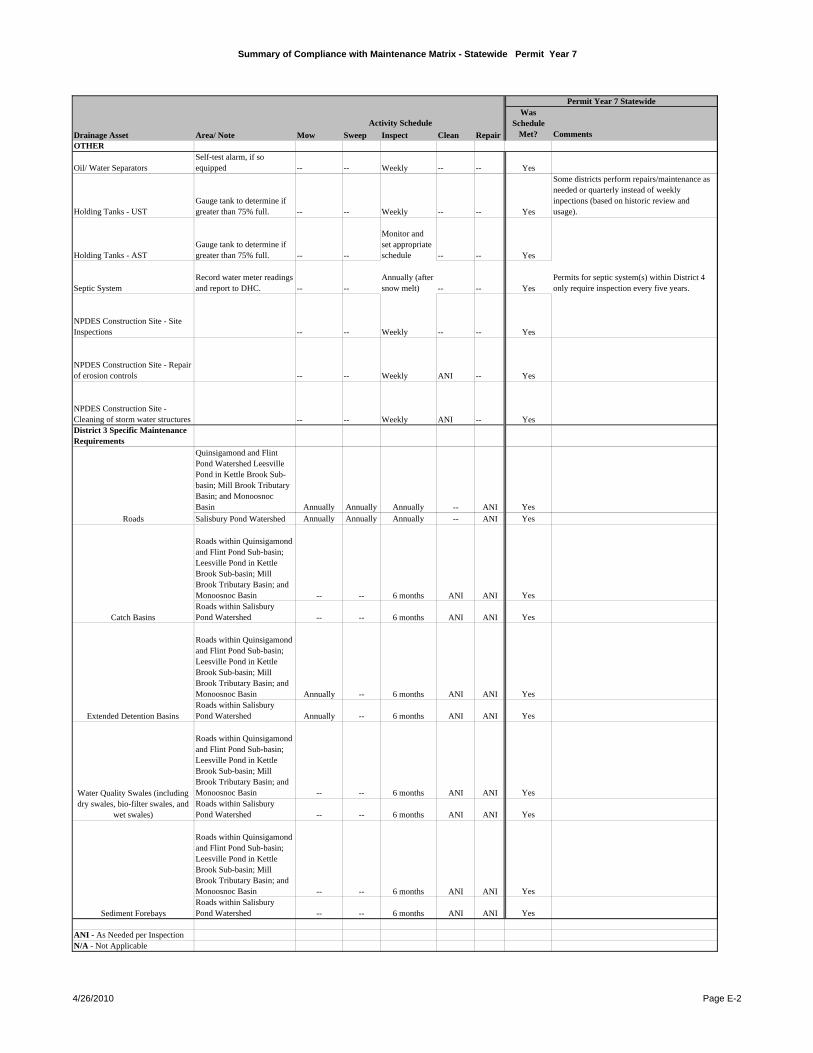
Summary of Compliance with Maintenance Matrix - Statewide Permit Year 7
Mow Sweep Inspect Clean Repair Comments
Was Schedule
Met?
Permit Year 7 Statewide
Drainage Asset Area/ Note
Activity Schedule
OTHER
Oil/ Water SeparatorsSelf-test alarm, if so equipped -- -- Weekly -- -- Yes
Holding Tanks - USTGauge tank to determine if greater than 75% full. -- -- Weekly -- -- Yes
Some districts perform repairs/maintenance as needed or quarterly instead of weekly inpections (based on historic review and usage).
Holding Tanks - ASTGauge tank to determine if greater than 75% full. -- --
Monitor and set appropriate schedule -- -- Yes
Septic SystemRecord water meter readings and report to DHC. -- --
Annually (after snow melt) -- -- Yes
Permits for septic system(s) within District 4 only require inspection every five years.
NPDES Construction Site - Site Inspections -- -- Weekly -- -- Yes
NPDES Construction Site - Repair of erosion controls -- -- Weekly ANI -- Yes
NPDES Construction Site - Cleaning of storm water structures -- -- Weekly ANI -- YesDistrict 3 Specific Maintenance Requirements
Quinsigamond and Flint Pond Watershed Leesville Pond in Kettle Brook Sub-basin; Mill Brook Tributary Basin; and Monoosnoc Basin Annually Annually Annually -- ANI Yes
Salisbury Pond Watershed Annually Annually Annually -- ANI Yes
Roads within Quinsigamond and Flint Pond Sub-basin; Leesville Pond in Kettle Brook Sub-basin; Mill Brook Tributary Basin; and Monoosnoc Basin -- -- 6 months ANI ANI YesRoads within Salisbury Pond Watershed -- -- 6 months ANI ANI Yes
Roads within Quinsigamond and Flint Pond Sub-basin; Leesville Pond in Kettle Brook Sub-basin; Mill Brook Tributary Basin; and Monoosnoc Basin Annually -- 6 months ANI ANI YesRoads within Salisbury Pond Watershed Annually -- 6 months ANI ANI Yes
Roads within Quinsigamond and Flint Pond Sub-basin; Leesville Pond in Kettle Brook Sub-basin; Mill Brook Tributary Basin; and Monoosnoc Basin -- -- 6 months ANI ANI YesRoads within Salisbury Pond Watershed -- -- 6 months ANI ANI Yes
Roads within Quinsigamond and Flint Pond Sub-basin; Leesville Pond in Kettle Brook Sub-basin; Mill Brook Tributary Basin; and Monoosnoc Basin -- -- 6 months ANI ANI YesRoads within Salisbury Pond Watershed -- -- 6 months ANI ANI Yes
ANI - As Needed per InspectionN/A - Not Applicable
Sediment Forebays
Roads
Catch Basins
Extended Detention Basins
Water Quality Swales (including dry swales, bio-filter swales, and
wet swales)
4/26/2010 Page E-2

NPDES Storm Water Management Plan Annual Report – Permit Year 7
Appendix F: Public Well Supply Matrix
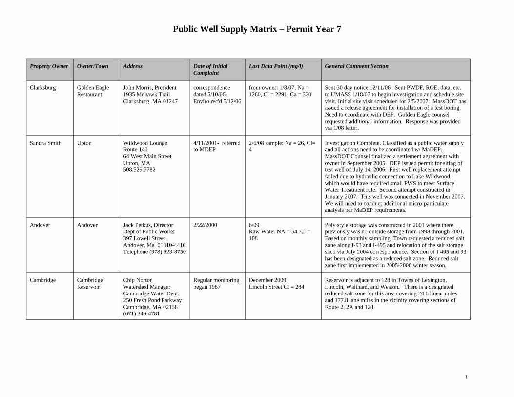
Public Well Supply Matrix – Permit Year 7
Property Owner Owner/Town Address Date of Initial Complaint
Last Data Point (mg/l) General Comment Section
Clarksburg Golden Eagle Restaurant
John Morris, President 1935 Mohawk Trail Clarksburg, MA 01247
correspondence dated 5/10/06-Enviro rec'd 5/12/06
from owner: 1/8/07; Na = 1260, Cl = 2291, Ca = 320
Sent 30 day notice 12/11/06. Sent PWDF, ROE, data, etc. to UMASS 1/18/07 to begin investigation and schedule site visit. Initial site visit scheduled for 2/5/2007. MassDOT has issued a release agreement for installation of a test boring. Need to coordinate with DEP. Golden Eagle counsel requested additional information. Response was provided via 1/08 letter.
Sandra Smith Upton Wildwood Lounge Route 140 64 West Main Street Upton, MA 508.529.7782
4/11/2001- referred to MDEP
2/6/08 sample: Na = 26, Cl= 4
Investigation Complete. Classified as a public water supply and all actions need to be coordinated w/ MaDEP. MassDOT Counsel finalized a settlement agreement with owner in September 2005. DEP issued permit for siting of test well on July 14, 2006. First well replacement attempt failed due to hydraulic connection to Lake Wildwood, which would have required small PWS to meet Surface Water Treatment rule. Second attempt constructed in January 2007. This well was connected in November 2007. We will need to conduct additional micro-particulate analysis per MaDEP requirements.
Andover Andover Jack Petkus, Director Dept of Public Works 397 Lowell Street Andover, Ma 01810-4416 Telephone (978) 623-8750
2/22/2000 6/09 Raw Water NA = 54, Cl = 108
Poly style storage was constructed in 2001 where there previously was no outside storage from 1998 through 2001. Based on monthly sampling, Town requested a reduced salt zone along I-93 and I-495 and relocation of the salt storage shed via July 2004 correspondence. Section of I-495 and 93 has been designated as a reduced salt zone. Reduced salt zone first implemented in 2005-2006 winter season.
Cambridge Cambridge Reservoir
Chip Norton Watershed Manager Cambridge Water Dept. 250 Fresh Pond Parkway Cambridge, MA 02138 (671) 349-4781
Regular monitoring began 1987
December 2009 Lincoln Street Cl = 284
Reservoir is adjacent to 128 in Towns of Lexington, Lincoln, Waltham, and Weston. There is a designated reduced salt zone for this area covering 24.6 linear miles and 177.8 lane miles in the vicinity covering sections of Route 2, 2A and 128.
1
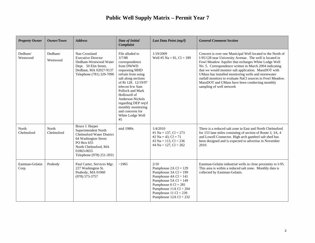
Public Well Supply Matrix – Permit Year 7
Property Owner Owner/Town Address Date of Initial Complaint
Last Data Point (mg/l) General Comment Section
Dedham/ Westwood
Dedham/
Westwood
Nan Crossland Executive Director Dedham-Westwood Water Dept. 50 Elm Street, Dedham, MA 02027-9137 Telephone (781) 329-7090
File alluded to 3/7/88 correspondence from DWWD requesting MHD refrain from using salt along sections of Rt 128. 12/19/97 telecon b/w Sam Pollock and Mark Hollowell of Anderson-Nichols regarding DEP req'd monthly monitoring and concerns for White Lodge Well #5
1/19/2009 Well #5 Na = 81, Cl = 189
Concern is over one Municipal Well located to the North of I-95/128 near University Avenue. The well is located in Fowl Meadow Aquifer that recharges White Lodge Well No. 5. Correspondence written in March 2004 indicating that we would monitor salt application. MassDOT with UMass has installed monitoring wells and stormwater outfall monitors to evaluate NaCl sources to Fowl Meadow. MassDOT and UMass have been conducting monthly sampling of well network
North Chelmsford
North Chelmsford
Bruce J. Harper Superintendent North Chelmsford Water District 64 Washington Street PO Box 655 North Chelmsford, MA 01863-0655 Telephone (978) 251-3931
mid 1980s 1/4/2010 #1 Na = 137, Cl = 273 #2 Na = 43, Cl = 71 #3 Na = 113, Cl = 236 #4 Na = 127, Cl = 262
There is a reduced salt zone in East and North Chelmsford for 153 lane miles consisting of section of Route 3, 3A, 4 and Lowell Connector. High arch gambrel salt shed has been designed and is expected to advertise in November 2010.
Eastman-Gelatin Corp.
Peabody Paul Carter, Services Mgr. 227 Washington St. Peabody, MA 01960 (978) 573-3757
~1965 2/10 Pumphouse 2A Cl = 129 Pumphouse 3A Cl = 199 Pumphouse 4A Cl = 141 Pumphouse 5A Cl = 149 Pumphouse 6 Cl = 281 Pumphouse 11A Cl = 204 Pumphouse 11 Cl = 239 Pumphouse 12A Cl = 232
Eastman-Gelatin industrial wells in close proximity to I-95. This area is within a reduced salt zone. Monthly data is collected by Eastman-Gelatin.
2
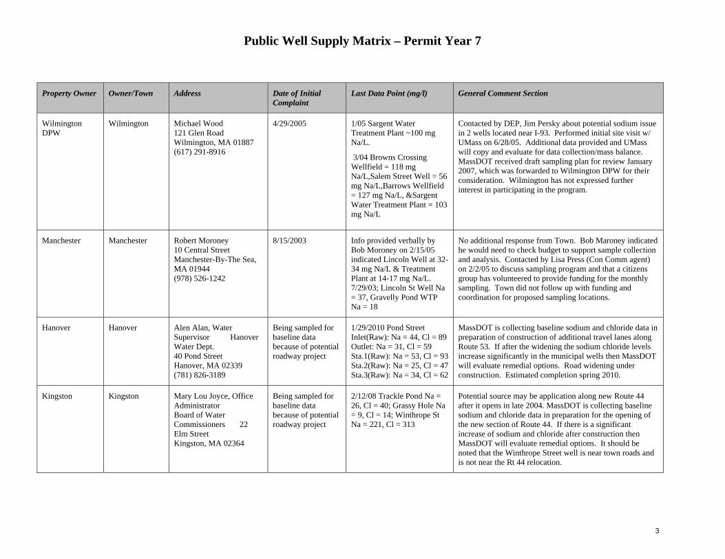
Public Well Supply Matrix – Permit Year 7
Property Owner Owner/Town Address Date of Initial Complaint
Last Data Point (mg/l) General Comment Section
Wilmington DPW
Wilmington Michael Wood 121 Glen Road Wilmington, MA 01887 (617) 291-8916
4/29/2005 1/05 Sargent Water Treatment Plant ~100 mg Na/L.
3/04 Browns Crossing Wellfield = 118 mg Na/L,Salem Street Well = 56 mg Na/L,Barrows Wellfield = 127 mg Na/L, &Sargent Water Treatment Plant = 103 mg Na/L
Contacted by DEP, Jim Persky about potential sodium issue in 2 wells located near I-93. Performed initial site visit w/ UMass on 6/28/05. Additional data provided and UMass will copy and evaluate for data collection/mass balance. MassDOT received draft sampling plan for review January 2007, which was forwarded to Wilmington DPW for their consideration. Wilmington has not expressed further interest in participating in the program.
Manchester Manchester Robert Moroney 10 Central Street Manchester-By-The Sea, MA 01944 (978) 526-1242
8/15/2003 Info provided verbally by Bob Moroney on 2/15/05 indicated Lincoln Well at 32-34 mg Na/L & Treatment Plant at 14-17 mg Na/L. 7/29/03; Lincoln St Well Na = 37, Gravelly Pond WTP Na = 18
No additional response from Town. Bob Maroney indicated he would need to check budget to support sample collection and analysis. Contacted by Lisa Press (Con Comm agent) on 2/2/05 to discuss sampling program and that a citizens group has volunteered to provide funding for the monthly sampling. Town did not follow up with funding and coordination for proposed sampling locations.
Hanover Hanover Alen Alan, Water Supervisor Hanover Water Dept. 40 Pond Street Hanover, MA 02339 (781) 826-3189
Being sampled for baseline data because of potential roadway project
1/29/2010 Pond Street Inlet(Raw): Na = 44, Cl = 89 Outlet: Na = 31, Cl = 59 Sta.1(Raw): Na = 53, Cl = 93 Sta.2(Raw): Na = 25, Cl = 47 Sta.3(Raw): Na = 34, Cl = 62
MassDOT is collecting baseline sodium and chloride data in preparation of construction of additional travel lanes along Route 53. If after the widening the sodium chloride levels increase significantly in the municipal wells then MassDOT will evaluate remedial options. Road widening under construction. Estimated completion spring 2010.
Kingston Kingston Mary Lou Joyce, Office Administrator Board of Water Commissioners 22 Elm Street Kingston, MA 02364
Being sampled for baseline data because of potential roadway project
2/12/08 Trackle Pond Na = 26, Cl = 40; Grassy Hole Na = 9, Cl = 14; Winthrope St Na = 221, Cl = 313
Potential source may be application along new Route 44 after it opens in late 2004. MassDOT is collecting baseline sodium and chloride data in preparation for the opening of the new section of Route 44. If there is a significant increase of sodium and chloride after construction then MassDOT will evaluate remedial options. It should be noted that the Winthrope Street well is near town roads and is not near the Rt 44 relocation.
3
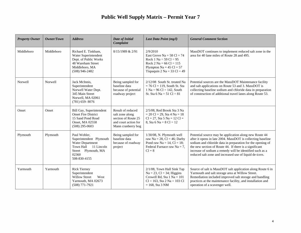
Public Well Supply Matrix – Permit Year 7
Property Owner Owner/Town Address Date of Initial Complaint
Last Data Point (mg/l) General Comment Section
Middleboro Middleboro Richard E. Tinkham, Water Superintendent Dept. of Public Works 48 Wareham Street Middleboro, MA (508) 946-2482
8/15/1989 & 2/91 2/9/2010 East Grove Na = 58 Cl = 74 Rock 1 Na = 59 Cl = 95 Rock 2 Na = 66 Cl = 115 Plympton Na = 45 Cl = 57 Tispaquin 2 Na = 33 Cl = 49
MassDOT continues to implement reduced salt zone in the area for 40 lane miles of Route 28 and 495.
Norwell Norwell Jack McInnis, Superintendent Norwell Water Dept. 345 Main Street Norwell, MA 02061 (781) 659- 8076
Being sampled for baseline data because of potential roadway project
2/12/08 South St. treated Na = 76 Cl = 119, South St. Sta 1 Na = 96 Cl = 142, South St. Sta 6 Na = 51 Cl = 81
Potential sources are the MassDOT Maintenance facility and salt applications on Route 53 and 3. MassDOT is collecting baseline sodium and chloride data in preparation of construction of additional travel lanes along Route 53.
Onset Onset Bill Gay, Superintendent Onset Fire District 15 Sand Pond Road Onset, MA 02558 (508) 295-0603
Result of reduced salt zone along section of Route 25 and court action for Mann cranberry bog
2/5/08, Red Brook Sta 3 Na = 20 Cl = 29, Sta 4 Na = 18 Cl = 27, Sta 5 Na = 12 Cl = 8, Sta 6 Na = 8 Cl = 12
Plymouth Plymouth Paul Wohler, Superintendent Plymouth Water Department Town Hall 11 Lincoln Street Plymouth, MA 02360 508-830-4155
Being sampled for baseline data because of roadway project
1/30/08, N. Plymouth well raw Na = 28, Cl = 46; Darby Pond raw Na = 14, Cl = 18; Federal Furnace raw Na = 7, Cl = 8
Potential source may be application along new Route 44 after it opens in late 2004. MassDOT is collecting baseline sodium and chloride data in preparation for the opening of the new section of Route 44. If there is a significant increase of sodium a remedy will be identified such as a reduced salt zone and increased use of liquid de-icers.
Yarmouth Yarmouth Rick Tierney Superintendent Willow Street West Yarmouth, MA 02673 (508) 771-7921
2/1/08, Town Hall Sink Tap Na = 23, Cl = 34; Higgins Crowell Rd, Sta 1 Na = 101 Cl = 163, Sta 2 Na = 103 Cl = 168, Sta 3 NM
Source of salt is MassDOT salt application along Route 6 in Yarmouth and salt storage area at Willow Street. Remediation included improved salt storage and handling practices at the maintenance facility, and installation and operation of a scavenger well.
4

NPDES Storm Water Management Plan Annual Report – Permit Year 7
Appendix G: TMDL Review Table
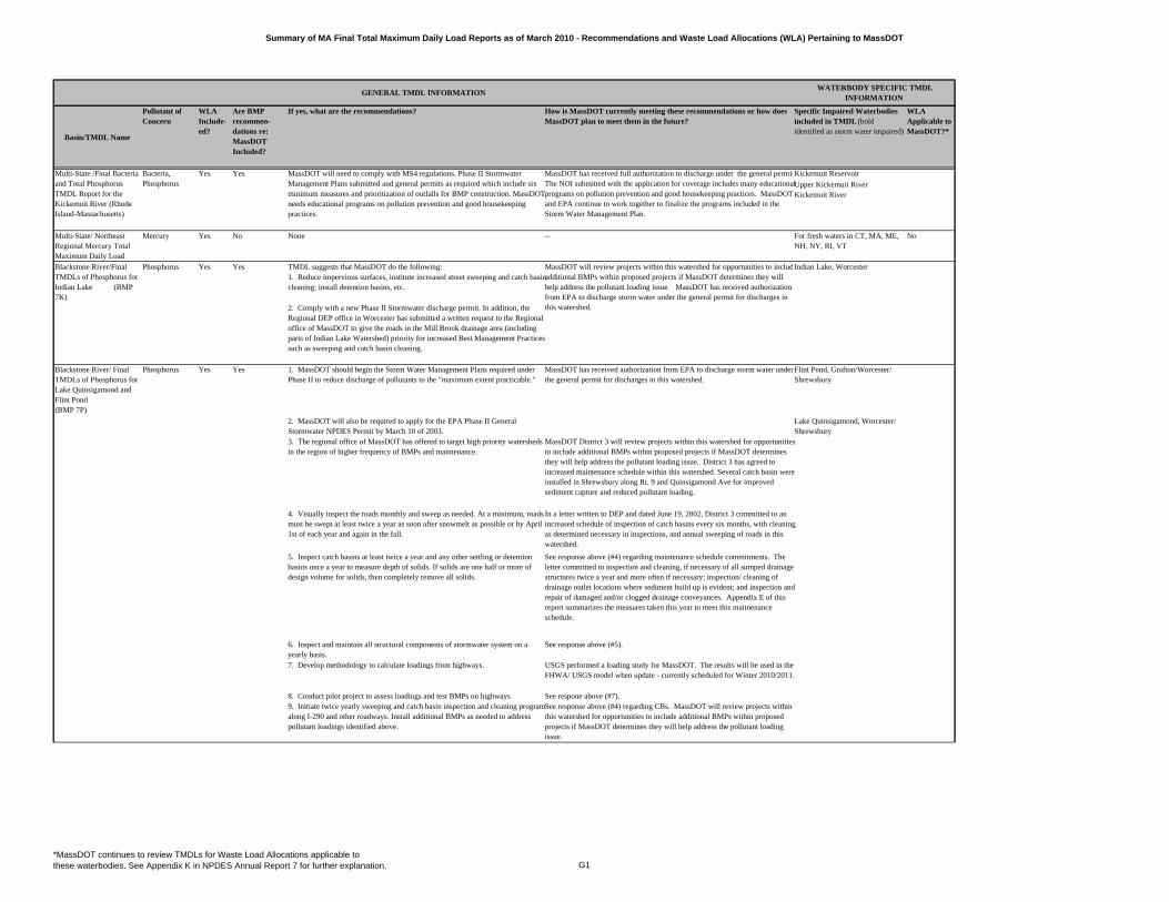
Summary of MA Final Total Maximum Daily Load Reports as of March 2010 - Recommendations and Waste Load Allocations (WLA) Pertaining to MassDOT
Basin/TMDL Name
Pollutant of Concern
WLA Include-ed?
Are BMP recommen-dations re: MassDOT Included?
If yes, what are the recommendations? How is MassDOT currently meeting these recommendations or how does MassDOT plan to meet them in the future?
Specific Impaired Waterbodies included in TMDL (bold identified as storm water impaired)
WLA Applicable to MassDOT?*
Yes Yes Kickemuit Reservoir
Upper Kickemuit RiverKickemuit River
Multi-State/ Northeast Regional Mercury Total Maximum Daily Load
Mercury Yes No None -- For fresh waters in CT, MA, ME, NH, NY, RI, VT
No
Phosphorus Yes Yes TMDL suggests that MassDOT do the following: Indian Lake, Worcester
Blackstone River/ Final TMDLs of Phosphorus for Lake Quinsigamond and Flint Pond (BMP 7P)
Phosphorus Yes Yes 1. MassDOT should begin the Storm Water Management Plans required under Phase II to reduce discharge of pollutants to the "maximum extent practicable."
MassDOT has received authorization from EPA to discharge storm water under the general permit for discharges in this watershed.
Flint Pond, Grafton/Worcester/ Shrewsbury
2. MassDOT will also be required to apply for the EPA Phase II General Stormwater NPDES Permit by March 10 of 2003.
Lake Quinsigamond, Worcester/ Shrewsbury
3. The regional office of MassDOT has offered to target high priority watersheds in the region of higher frequency of BMPs and maintenance.
MassDOT District 3 will review projects within this watershed for opportunities to include additional BMPs within proposed projects if MassDOT determines they will help address the pollutant loading issue. District 3 has agreed to increased maintenance schedule within this watershed. Several catch basin were installed in Shrewsbury along Rt. 9 and Quinsigamond Ave for improved sediment capture and reduced pollutant loading.
6. Inspect and maintain all structural components of stormwater system on a yearly basis.
See response above (#5).
7. Develop methodology to calculate loadings from highways. USGS performed a loading study for MassDOT. The results will be used in the FHWA/ USGS model when update - currently scheduled for Winter 2010/2011.
8. Conduct pilot project to assess loadings and test BMPs on highways See respone above (#7).9. Initiate twice yearly sweeping and catch basin inspection and cleaning program along I-290 and other roadways. Install additional BMPs as needed to address pollutant loadings identified above.
See response above (#4) regarding CBs. MassDOT will review projects within this watershed for opportunities to include additional BMPs within proposed projects if MassDOT determines they will help address the pollutant loading issue.
Multi-State /Final Bacteria and Total Phosphorus TMDL Report for the Kickemuit River (Rhode Island-Massachusetts)
Bacteria, Phosphorus
MassDOT will need to comply with MS4 regulations. Phase II Stormwater Management Plans submitted and general permits as required which include six minimum measures and prioritization of outfalls for BMP construction. MassDOT needs educational programs on pollution prevention and good housekeeping practices.
MassDOT has received full authorization to discharge under the general permitThe NOI submitted with the application for coverage includes many educational programs on pollution prevention and good housekeeping practices. MassDOT and EPA continue to work together to finalize the programs included in the Storm Water Management Plan.
Blackstone River/Final TMDLs of Phosphorus for Indian Lake (BMP 7K)
MassDOT will review projects within this watershed for opportunities to includadditional BMPs within proposed projects if MassDOT determines they will help address the pollutant loading issue. MassDOT has received authorization from EPA to discharge storm water under the general permit for discharges in this watershed.
1. Reduce impervious surfaces, institute increased street sweeping and catch basin cleaning; install detention basins, etc.
2. Comply with a new Phase II Stormwater discharge permit. In addition, the Regional DEP office in Worcester has submitted a written request to the Regional office of MassDOT to give the roads in the Mill Brook drainage area (including parts of Indian Lake Watershed) priority for increased Best Management Practices such as sweeping and catch basin cleaning.
4. Visually inspect the roads monthly and sweep as needed. At a minimum, roads must be swept at least twice a year as soon after snowmelt as possible or by April 1st of each year and again in the fall.
In a letter written to DEP and dated June 19, 2002, District 3 committed to an increased schedule of inspection of catch basins every six months, with cleaning as determined necessary in inspections, and annual sweeping of roads in this watershed.
5. Inspect catch basins at least twice a year and any other settling or detention basins once a year to measure depth of solids. If solids are one half or more of design volume for solids, then completely remove all solids.
See response above (#4) regarding maintenance schedule commitments. The letter committed to inspection and cleaning, if necessary of all sumped drainage structures twice a year and more often if necessary; inspection/ cleaning of drainage outlet locations where sediment build up is evident; and inspection and repair of damaged and/or clogged drainage conveyances. Appendix E of this report summarizes the measures taken this year to meet this maitnenance schedule.
GENERAL TMDL INFORMATION WATERBODY SPECIFIC TMDL
INFORMATION
*MassDOT continues to review TMDLs for Waste Load Allocations applicable to these waterbodies. See Appendix K in NPDES Annual Report 7 for further explanation. G1
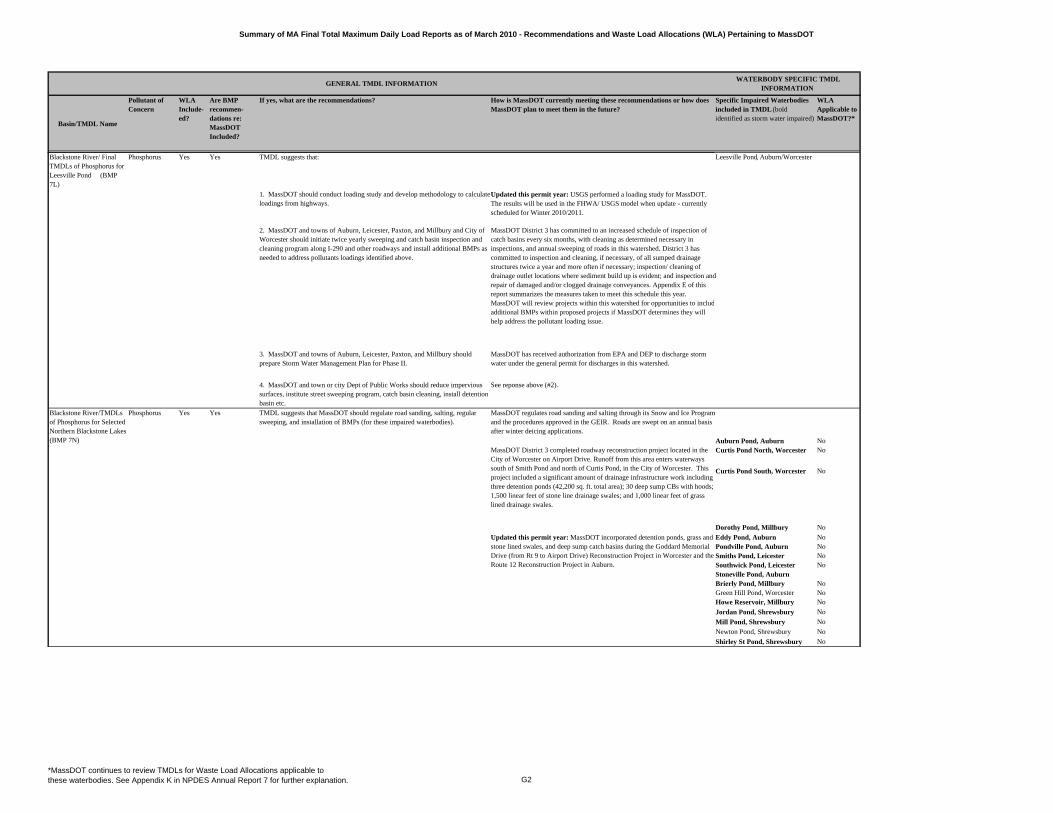
Summary of MA Final Total Maximum Daily Load Reports as of March 2010 - Recommendations and Waste Load Allocations (WLA) Pertaining to MassDOT
Basin/TMDL Name
Pollutant of Concern
WLA Include-ed?
Are BMP recommen-dations re: MassDOT Included?
If yes, what are the recommendations? How is MassDOT currently meeting these recommendations or how does MassDOT plan to meet them in the future?
Specific Impaired Waterbodies included in TMDL (bold identified as storm water impaired)
WLA Applicable to MassDOT?*
GENERAL TMDL INFORMATION WATERBODY SPECIFIC TMDL
INFORMATION
Phosphorus Yes Yes TMDL suggests that: Leesville Pond, Auburn/Worcester
1. MassDOT should conduct loading study and develop methodology to calculate loadings from highways.
Updated this permit year: USGS performed a loading study for MassDOT. The results will be used in the FHWA/ USGS model when update - currently scheduled for Winter 2010/2011.
2. MassDOT and towns of Auburn, Leicester, Paxton, and Millbury and City of Worcester should initiate twice yearly sweeping and catch basin inspection and cleaning program along I-290 and other roadways and install additional BMPs as needed to address pollutants loadings identified above.
MassDOT District 3 has committed to an increased schedule of inspection of catch basins every six months, with cleaning as determined necessary in inspections, and annual sweeping of roads in this watershed. District 3 has committed to inspection and cleaning, if necessary, of all sumped drainage structures twice a year and more often if necessary; inspection/ cleaning of drainage outlet locations where sediment build up is evident; and inspection and repair of damaged and/or clogged drainage conveyances. Appendix E of this report summarizes the measures taken to meet this schedule this year. MassDOT will review projects within this watershed for opportunities to includadditional BMPs within proposed projects if MassDOT determines they will help address the pollutant loading issue.
3. MassDOT and towns of Auburn, Leicester, Paxton, and Millbury should prepare Storm Water Management Plan for Phase II.
MassDOT has received authorization from EPA and DEP to discharge storm water under the general permit for discharges in this watershed.
4. MassDOT and town or city Dept of Public Works should reduce impervious surfaces, institute street sweeping program, catch basin cleaning, install detention basin etc.
See reponse above (#2).
Phosphorus Yes Yes TMDL suggests that MassDOT should regulate road sanding, salting, regular sweeping, and installation of BMPs (for these impaired waterbodies).
MassDOT regulates road sanding and salting through its Snow and Ice Program and the procedures approved in the GEIR. Roads are swept on an annual basis after winter deicing applications.
Auburn Pond, Auburn NoCurtis Pond North, Worcester No
Curtis Pond South, Worcester No
Dorothy Pond, Millbury No
Eddy Pond, Auburn NoPondville Pond, Auburn NoSmiths Pond, Leicester NoSouthwick Pond, Leicester NoStoneville Pond, AuburnBrierly Pond, Millbury NoGreen Hill Pond, Worcester NoHowe Reservoir, Millbury No
Jordan Pond, Shrewsbury No
Mill Pond, Shrewsbury No
Newton Pond, Shrewsbury No
Shirley St Pond, Shrewsbury No
Blackstone River/TMDLs of Phosphorus for Selected Northern Blackstone Lakes (BMP 7N)
Blackstone River/ Final TMDLs of Phosphorus for Leesville Pond (BMP 7L)
Updated this permit year: MassDOT incorporated detention ponds, grass and stone lined swales, and deep sump catch basins during the Goddard Memorial Drive (from Rt 9 to Airport Drive) Reconstruction Project in Worcester and the Route 12 Reconstruction Project in Auburn.
MassDOT District 3 completed roadway reconstruction project located in the City of Worcester on Airport Drive. Runoff from this area enters waterways south of Smith Pond and north of Curtis Pond, in the City of Worcester. This project included a significant amount of drainage infrastructure work including three detention ponds (42,200 sq. ft. total area); 30 deep sump CBs with hoods; 1,500 linear feet of stone line drainage swales; and 1,000 linear feet of grass lined drainage swales.
*MassDOT continues to review TMDLs for Waste Load Allocations applicable to these waterbodies. See Appendix K in NPDES Annual Report 7 for further explanation. G2
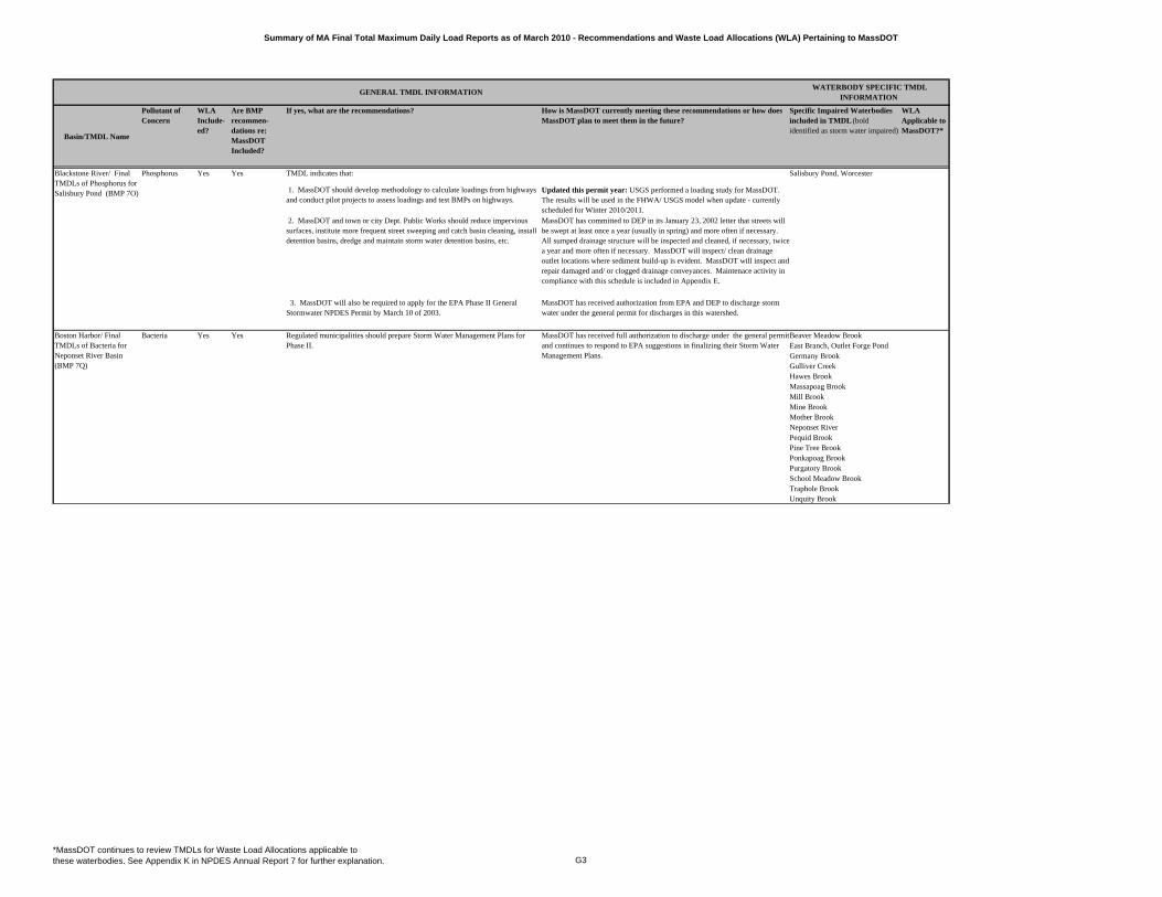
Summary of MA Final Total Maximum Daily Load Reports as of March 2010 - Recommendations and Waste Load Allocations (WLA) Pertaining to MassDOT
Basin/TMDL Name
Pollutant of Concern
WLA Include-ed?
Are BMP recommen-dations re: MassDOT Included?
If yes, what are the recommendations? How is MassDOT currently meeting these recommendations or how does MassDOT plan to meet them in the future?
Specific Impaired Waterbodies included in TMDL (bold identified as storm water impaired)
WLA Applicable to MassDOT?*
GENERAL TMDL INFORMATION WATERBODY SPECIFIC TMDL
INFORMATION
TMDL indicates that:
1. MassDOT should develop methodology to calculate loadings from highways and conduct pilot projects to assess loadings and test BMPs on highways.
Updated this permit year: USGS performed a loading study for MassDOT. The results will be used in the FHWA/ USGS model when update - currently scheduled for Winter 2010/2011.
2. MassDOT and town or city Dept. Public Works should reduce impervious surfaces, institute more frequent street sweeping and catch basin cleaning, install detention basins, dredge and maintain storm water detention basins, etc.
MassDOT has committed to DEP in its January 23, 2002 letter that streets will be swept at least once a year (usually in spring) and more often if necessary. All sumped drainage structure will be inspected and cleaned, if necessary, twice a year and more often if necessary. MassDOT will inspect/ clean drainage outlet locations where sediment build-up is evident. MassDOT will inspect and repair damaged and/ or clogged drainage conveyances. Maintenace activity in compliance with this schedule is included in Appendix E.
3. MassDOT will also be required to apply for the EPA Phase II General Stormwater NPDES Permit by March 10 of 2003.
MassDOT has received authorization from EPA and DEP to discharge storm water under the general permit for discharges in this watershed.
Bacteria Yes Yes Beaver Meadow BrookEast Branch, Outlet Forge PondGermany BrookGulliver CreekHawes BrookMassapoag BrookMill BrookMine BrookMother BrookNeponset RiverPequid BrookPine Tree BrookPonkapoag BrookPurgatory BrookSchool Meadow BrookTraphole BrookUnquity Brook
Blackstone River/ Final TMDLs of Phosphorus for Salisbury Pond (BMP 7O)
Salisbury Pond, WorcesterPhosphorus Yes Yes
Boston Harbor/ Final TMDLs of Bacteria for Neponset River Basin (BMP 7Q)
Regulated municipalities should prepare Storm Water Management Plans for Phase II.
MassDOT has received full authorization to discharge under the general permit and continues to respond to EPA suggestions in finalizing their Storm Water Management Plans.
*MassDOT continues to review TMDLs for Waste Load Allocations applicable to these waterbodies. See Appendix K in NPDES Annual Report 7 for further explanation. G3
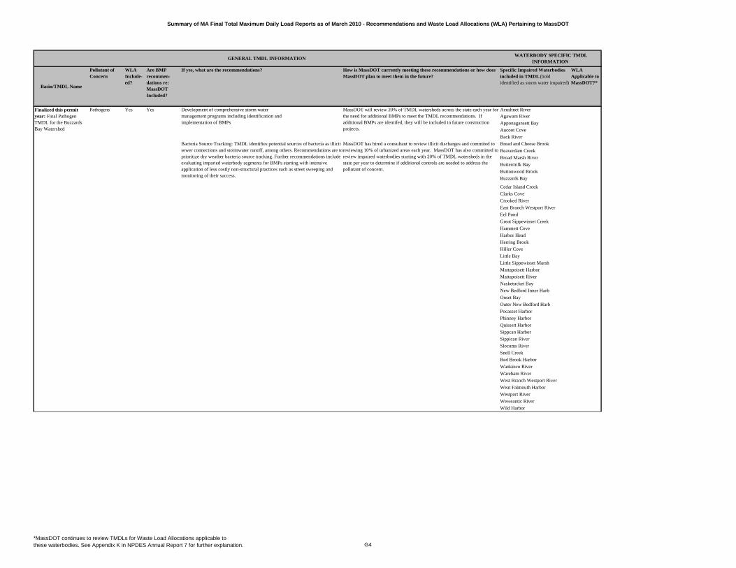
Summary of MA Final Total Maximum Daily Load Reports as of March 2010 - Recommendations and Waste Load Allocations (WLA) Pertaining to MassDOT
Basin/TMDL Name
Pollutant of Concern
WLA Include-ed?
Are BMP recommen-dations re: MassDOT Included?
If yes, what are the recommendations? How is MassDOT currently meeting these recommendations or how does MassDOT plan to meet them in the future?
Specific Impaired Waterbodies included in TMDL (bold identified as storm water impaired)
WLA Applicable to MassDOT?*
GENERAL TMDL INFORMATION WATERBODY SPECIFIC TMDL
INFORMATION
Pathogens Acushnet RiverAgawam River
Apponagansett Bay
Aucoot Cove
Back River
Bread and Cheese Brook
Beaverdam Creek
Broad Marsh River
Buttermilk Bay
Buttonwood Brook
Buzzards Bay
Cedar Island Creek
Clarks Cove
Crooked River
East Branch Westport River
Eel Pond
Great Sippewisset Creek
Hammett Cove
Harbor Head
Herring Brook
Hiller Cove
Little Bay
Little Sippewisset Marsh
Mattapoisett Harbor
Mattapoisett River
Nasketucket Bay
New Bedford Inner Harb
Onset Bay
Outer New Bedford Harb
Pocasset Harbor
Phinney Harbor
Quissett Harbor
Sippcan Harbor
Sippican River
Slocums River
Snell Creek
Red Brook Harbor
Wankinco River
Wareham River
West Branch Westport River
Weat Falmouth Harbor
Westport River
Weweantic River
Wild Harbor
Finalized this permit year: Final Pathogen TMDL for the Buzzards Bay Watershed
Yes Yes Development of comprehensive storm watermanagement programs including identification andimplementation of BMPs
MassDOT will review 20% of TMDL watersheds across the state each year for the need for additional BMPs to meet the TMDL recommendations. If additional BMPs are identifed, they will be included in future construction projects.
Bacteria Source Tracking: TMDL identifies potential sources of bacteria as illicit sewer connections and stormwater runoff, among others. Recommendations are to prioritize dry weather bacteria source tracking. Further recommendations include evaluating imparied waterbody segments for BMPs starting with intensive application of less costly non-structural practices such as street sweeping and monitoring of their success.
MassDOT has hired a consultant to review illicit discharges and commited to reviewing 10% of urbanized areas each year. MassDOT has also committed to review impaired waterbodies starting with 20% of TMDL watersheds in the state per year to determine if additional controls are needed to address the pollutant of concern.
*MassDOT continues to review TMDLs for Waste Load Allocations applicable to these waterbodies. See Appendix K in NPDES Annual Report 7 for further explanation. G4
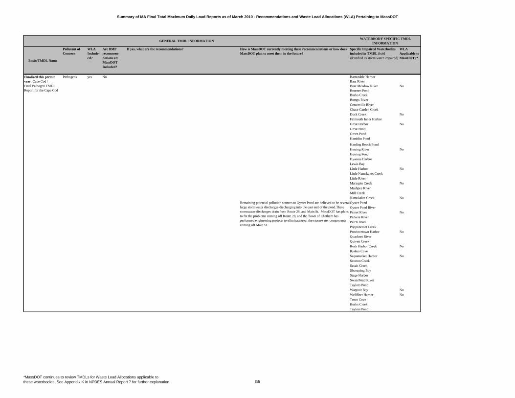
Summary of MA Final Total Maximum Daily Load Reports as of March 2010 - Recommendations and Waste Load Allocations (WLA) Pertaining to MassDOT
Basin/TMDL Name
Pollutant of Concern
WLA Include-ed?
Are BMP recommen-dations re: MassDOT Included?
If yes, what are the recommendations? How is MassDOT currently meeting these recommendations or how does MassDOT plan to meet them in the future?
Specific Impaired Waterbodies included in TMDL (bold identified as storm water impaired)
WLA Applicable to MassDOT?*
GENERAL TMDL INFORMATION WATERBODY SPECIFIC TMDL
INFORMATION
Pathogens yes No Barnstable HarborBass RiverBoat Meadow River NoBournes PondBucks Creek
Bumps River
Centerville River
Chase Garden Creek
Duck Creek No
Falmouth Inner Harbor
Great Harbor No
Great Pond
Green Pond
Hamblin Pond
Harding Beach Pond
Herring River No
Herring Pond
Hyannis Harbor
Lewis Bay
Little Harbor No
Little Namskaket Creek
Little River
Maraspin Creek No
Mashpee River
Mill Creek
Namskaket Creek No
Oyster Pond
Oyster Pond River
Pamet River No
Parkers River
Perch Pond
Popponesset Creek
Provincetown Harbor No
Quashnet River
Quivett Creek
Rock Harbor Creek No
Ryders Cove
Saquatucket Harbor No
Scorton Creek
Sesuit Creek
Shoestring Bay
Stage Harbor
Swan Pond River
Taylors Pond
Waquoit Bay No
Wellfleet Harbor No
Town Cove
Bucks Creek
Taylors Pond
Remaining potential pollution sources to Oyster Pond are believed to be several large stormwater discharges discharging into the east end of the pond.These stormwater discharges drain from Route 28, and Main St. MassDOT has plans to fix the problems coming off Route 28, and the Town of Chatham has performed engineering projects to eliminate/treat the stormwater components coming off Main St.
Finalized this permit year: Cape Cod / Final Pathogen TMDL Report for the Cape Cod
*MassDOT continues to review TMDLs for Waste Load Allocations applicable to these waterbodies. See Appendix K in NPDES Annual Report 7 for further explanation. G5
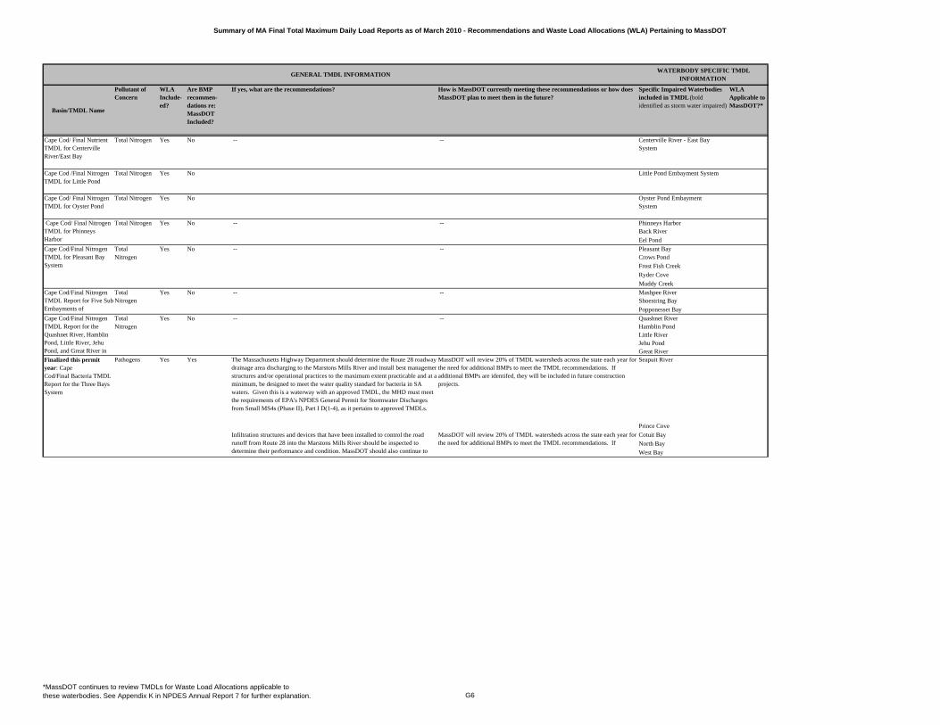
Summary of MA Final Total Maximum Daily Load Reports as of March 2010 - Recommendations and Waste Load Allocations (WLA) Pertaining to MassDOT
Basin/TMDL Name
Pollutant of Concern
WLA Include-ed?
Are BMP recommen-dations re: MassDOT Included?
If yes, what are the recommendations? How is MassDOT currently meeting these recommendations or how does MassDOT plan to meet them in the future?
Specific Impaired Waterbodies included in TMDL (bold identified as storm water impaired)
WLA Applicable to MassDOT?*
GENERAL TMDL INFORMATION WATERBODY SPECIFIC TMDL
INFORMATION
Cape Cod/ Final Nutrient TMDL for Centerville River/East Bay
Total Nitrogen Yes No -- -- Centerville River - East Bay System
Cape Cod /Final Nitrogen TMDL for Little Pond
Total Nitrogen Yes No Little Pond Embayment System
Cape Cod/ Final Nitrogen TMDL for Oyster Pond
Total Nitrogen Yes No Oyster Pond Embayment System
-- -- Phinneys Harbor Back River
Eel Pond
Total -- -- Pleasant BayNitrogen Crows Pond
Frost Fish Creek
Ryder Cove
Muddy Creek
-- -- Mashpee RiverShoestring Bay
Popponesset Bay
Total -- -- Quashnet RiverNitrogen Hamblin Pond
Little RiverJehu PondGreat River
Pathogens The Massachusetts Highway Department should determine the Route 28 roadway drainage area discharging to the Marstons Mills River and install best managemenstructures and/or operational practices to the maximum extent practicable and at a minimum, be designed to meet the water quality standard for bacteria in SA waters. Given this is a waterway with an approved TMDL, the MHD must meet the requirements of EPA's NPDES General Permit for Stormwater Discharges from Small MS4s (Phase II), Part I D(1-4), as it pertains to approved TMDLs.
MassDOT will review 20% of TMDL watersheds across the state each year for the need for additional BMPs to meet the TMDL recommendations. If additional BMPs are identifed, they will be included in future construction projects.
Seapuit River
Prince Cove
Cotuit Bay
North Bay
West Bay
Cape Cod/ Final Nitrogen TMDL for Phinneys Harbor
Total Nitrogen Yes No
Cape Cod/Final Nitrogen TMDL for Pleasant Bay System
Yes No
Infiltration structures and devices that have been installed to control the road runoff from Route 28 into the Marstons Mills River should be inspected to determine their performance and condition. MassDOT should also continue to id if d i l h i i bl b
MassDOT will review 20% of TMDL watersheds across the state each year for the need for additional BMPs to meet the TMDL recommendations. If
Cape Cod/Final Nitrogen TMDL Report for Five SubEmbayments of
Total Nitrogen
Yes No
Cape Cod/Final Nitrogen TMDL Report for the Quashnet River, Hamblin Pond, Little River, Jehu Pond, and Great River in
Yes No
Finalized this permit year: Cape Cod/Final Bacteria TMDL Report for the Three Bays System
Yes Yes
*MassDOT continues to review TMDLs for Waste Load Allocations applicable to these waterbodies. See Appendix K in NPDES Annual Report 7 for further explanation. G6
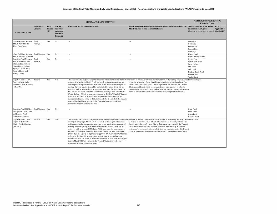
Summary of MA Final Total Maximum Daily Load Reports as of March 2010 - Recommendations and Waste Load Allocations (WLA) Pertaining to MassDOT
Basin/TMDL Name
Pollutant of Concern
WLA Include-ed?
Are BMP recommen-dations re: MassDOT Included?
If yes, what are the recommendations? How is MassDOT currently meeting these recommendations or how does MassDOT plan to meet them in the future?
Specific Impaired Waterbodies included in TMDL (bold identified as storm water impaired)
WLA Applicable to MassDOT?*
GENERAL TMDL INFORMATION WATERBODY SPECIFIC TMDL
INFORMATION
Total -- -- Cotuit BayNitrogen North Bay
Prince Cove
Seapuit River
West Bay
Total Nitrogen -- -- Harbor HeadWest Falmouth Harbor
Total -- -- Oyster PondNitrogen Oyster Pond River
Stage Harbor
Mill Pond
Mill Creek
Harding Beach Pond
Bucks Creek
Taylors Pond
Cape Cod /Final TMDL Report of Bacteria for Frost Fish Creek, Chatham (BMP 7F)
Bacteria Yes Yes The Massachusetts Highway Department should determine the Route 28 roadway drainage discharging to Muddy Creek and install best management structures and/or operational practices to the maximum extent practicable with a goal of meeting the water quality standard for bacteria in SA waters. Given this is a waterway with an approved TMDL, the MHD must meet the requirements of EPA's NPDES General Permit for Stormwater Discharges from small MS4s (Phase II), Part i D(1-4), as it pertains to approved TMDLs." MassDEP has not deferred to the Route 28 reconstruction project since we do not have any information about the extent or the time schedule for it. MassDEP also suggests that the MassDOT Dept. work with the Town of Chatham to work out a reasonable schedule for these activities.
Because of funding constraints and the condition of the existing roadway, there is no plan to resurface Route 28 within the boundaries of Muddy or Frost Fish Creeks within the next 4 years. District 5 personnel has met with the Town of Chatham and identified their concerns, and some measures may be taken to reduce and/or treat runoff to the creeks if time and funding permits. The District hopes to implement these measure within the next year prior to resurfacing.
Frost Fish Creek
-- -- Great PondPerch Pond
Green Pond
Bournes Pond
Cape Cod/ Final TMDL Report of Bacteria for Muddy Creek, Chatham (BMP 7G)
Bacteria Yes Yes The Massachusetts Highway Department should determine the Route 28 roadway drainage discharging to Muddy Creek and install best management structures and/or operational practices to the maximum extent practicable with a goal of meeting the water quality standard for bacteria in SA waters. Given this is a waterway with an approved TMDL, the MHD must meet the requirements of EPA's NPDES General Permit for Stormwater Discharges from small MS4s (Phase II), Part i D(1-4), as it pertains to approved TMDLs." MassDEP has not deferred to the Route 28 reconstruction project since we do not have any information about the extent or the time schedule for it. MassDEP also suggests that the MassDOT Dept. work with the Town of Chatham to work out a reasonable schedule for these activities.
Because of funding constraints and the condition of the existing roadway, there is no plan to resurface Route 28 within the boundaries of Muddy or Frost Fish Creeks within the next 5 years. District 5 personnel have met with the Town of Chatham and identified their concerns, and some measures may be taken to reduce and/or treat runoff to the creeks if time and funding permits. The District hopes to implement these measure within the next 2 years prior to resurfacing.
Muddy Creek
Cape Cod/ Final Nitrogen TMDL Report for the Three Bays System
Yes No
Cape Cod/Final Nitrogen TMDL for West Falmouth
Yes No
Cape Cod/Final Nitrogen TMDL Report for Five Chatham Embayments (Stage Harbor, Sulphur Springs, Taylors Pond, Bassing Harbor and Muddy Creek)
Yes No
Cape Cod/Final TMDLs of Nitrogen for Great, Green, and Bournes Pond Embayment Systems
Total Nitrogen Yes No
*MassDOT continues to review TMDLs for Waste Load Allocations applicable to these waterbodies. See Appendix K in NPDES Annual Report 7 for further explanation. G7
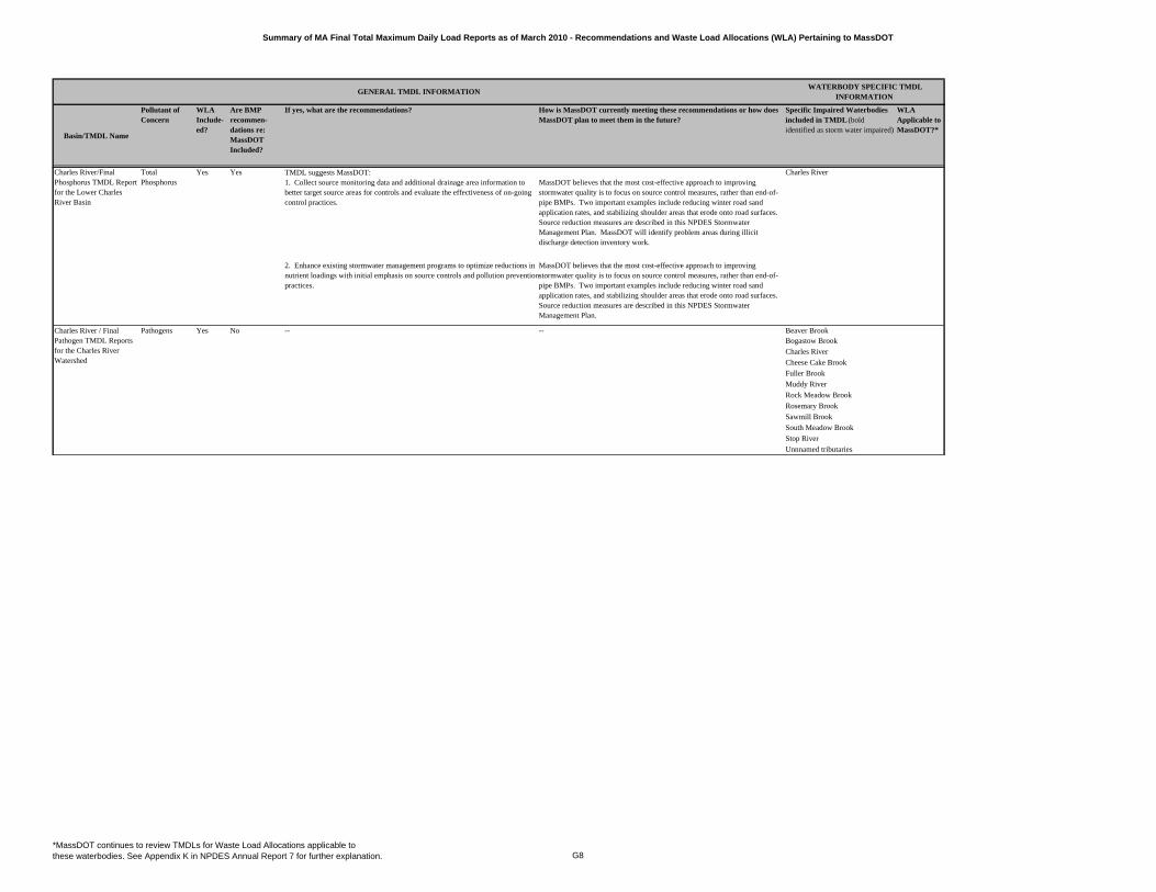
Summary of MA Final Total Maximum Daily Load Reports as of March 2010 - Recommendations and Waste Load Allocations (WLA) Pertaining to MassDOT
Basin/TMDL Name
Pollutant of Concern
WLA Include-ed?
Are BMP recommen-dations re: MassDOT Included?
If yes, what are the recommendations? How is MassDOT currently meeting these recommendations or how does MassDOT plan to meet them in the future?
Specific Impaired Waterbodies included in TMDL (bold identified as storm water impaired)
WLA Applicable to MassDOT?*
GENERAL TMDL INFORMATION WATERBODY SPECIFIC TMDL
INFORMATION
TMDL suggests MassDOT:
Pathogens Beaver BrookBogastow Brook
Charles River
Cheese Cake Brook
Fuller Brook
Muddy River
Rock Meadow Brook
Rosemary Brook
Sawmill Brook
South Meadow Brook
Stop River
Unnnamed tributaries
-- --
Charles River/Final Phosphorus TMDL Report for the Lower Charles River Basin
Charles RiverTotal Phosphorus
Yes Yes1. Collect source monitoring data and additional drainage area information to better target source areas for controls and evaluate the effectiveness of on-going control practices.
MassDOT believes that the most cost-effective approach to improving stormwater quality is to focus on source control measures, rather than end-of-pipe BMPs. Two important examples include reducing winter road sand application rates, and stabilizing shoulder areas that erode onto road surfaces. Source reduction measures are described in this NPDES Stormwater Management Plan. MassDOT will identify problem areas during illicit discharge detection inventory work.
2. Enhance existing stormwater management programs to optimize reductions in nutrient loadings with initial emphasis on source controls and pollution prevention practices.
MassDOT believes that the most cost-effective approach to improving stormwater quality is to focus on source control measures, rather than end-of-pipe BMPs. Two important examples include reducing winter road sand application rates, and stabilizing shoulder areas that erode onto road surfaces. Source reduction measures are described in this NPDES Stormwater Management Plan.
Charles River / Final Pathogen TMDL Reports for the Charles River Watershed
Yes No
*MassDOT continues to review TMDLs for Waste Load Allocations applicable to these waterbodies. See Appendix K in NPDES Annual Report 7 for further explanation. G8
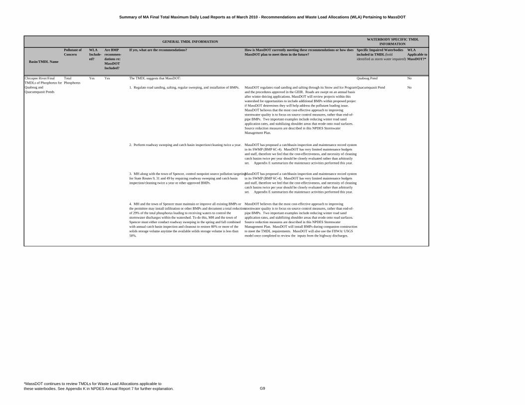
Summary of MA Final Total Maximum Daily Load Reports as of March 2010 - Recommendations and Waste Load Allocations (WLA) Pertaining to MassDOT
Basin/TMDL Name
Pollutant of Concern
WLA Include-ed?
Are BMP recommen-dations re: MassDOT Included?
If yes, what are the recommendations? How is MassDOT currently meeting these recommendations or how does MassDOT plan to meet them in the future?
Specific Impaired Waterbodies included in TMDL (bold identified as storm water impaired)
WLA Applicable to MassDOT?*
GENERAL TMDL INFORMATION WATERBODY SPECIFIC TMDL
INFORMATION
Total Phosphorus
The TMDL suggests that MassDOT: Quaboag Pond No
1. Regulate road sanding, salting, regular sweeping, and installation of BMPs. MassDOT regulates road sanding and salting through its Snow and Ice Program and the procedures approved in the GEIR. Roads are swept on an annual basis after winter deicing applications. MassDOT will review projects within this watershed for opportunities to include additional BMPs within proposed projectif MassDOT determines they will help address the pollutant loading issue. MassDOT believes that the most cost-effective approach to improving stormwater quality is to focus on source control measures, rather than end-of-pipe BMPs. Two important examples include reducing winter road sand application rates, and stabilizing shoulder areas that erode onto road surfaces. Source reduction measures are described in this NPDES Stormwater Management Plan.
Quacumquasit Pond No
2. Perform roadway sweeping and catch basin inspection/cleaning twice a year. MassDOT has proposed a catchbasin inspection and maintenance record system in its SWMP (BMP 6C-4). MassDOT has very limited maintenance budgets and staff, therefore we feel that the cost-effectiveness, and necessity of cleaning catch basins twice per year should be closely evaluated rather than arbitrarily set. Appendix E summarizes the maintenace activities performed this year.
3. MH along with the town of Spencer, control nonpoint source pollution targeting for State Routes 9, 31 and 49 by requiring roadway sweeping and catch basin inspection/cleaning twice a year or other approved BMPs.
MassDOT has proposed a catchbasin inspection and maintenance record system in its SWMP (BMP 6C-4). MassDOT has very limited maintenance budgets and staff, therefore we feel that the cost-effectiveness, and necessity of cleaning catch basins twice per year should be closely evaluated rather than arbitrarily set. Appendix E summarizes the maintenace activities performed this year.
4. MH and the town of Spencer must maintain or improve all existing BMPs or the permittee may install infiltration or other BMPs and document a total reduction of 29% of the total phosphorus loading to receiving waters to control the stormwater discharges within the watershed. To do this, MH and the town of Spencer must either conduct roadway sweeping in the spring and fall combined with annual catch basin inspection and cleanout to restore 80% or more of the solids storage volume anytime the available solids storage volume is less than 50%.
MassDOT believes that the most cost-effective approach to improving stormwater quality is to focus on source control measures, rather than end-of-pipe BMPs. Two important examples include reducing winter road sand application rates, and stabilizing shoulder areas that erode onto road surfaces. Source reduction measures are described in this NPDES Stormwater Management Plan. MassDOT will install BMPs during companion construction to meet the TMDL requirements. MassDOT will also use the FHWA/ USGS model once completed to review the inputs from the highway discharges.
Chicopee River/Final TMDLs of Phosphorus for Quaboag and Quacumquasit Ponds
Yes Yes
*MassDOT continues to review TMDLs for Waste Load Allocations applicable to these waterbodies. See Appendix K in NPDES Annual Report 7 for further explanation. G9
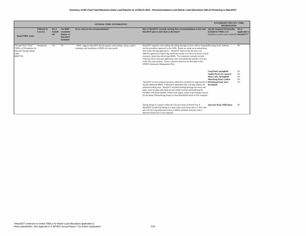
Summary of MA Final Total Maximum Daily Load Reports as of March 2010 - Recommendations and Waste Load Allocations (WLA) Pertaining to MassDOT
Basin/TMDL Name
Pollutant of Concern
WLA Include-ed?
Are BMP recommen-dations re: MassDOT Included?
If yes, what are the recommendations? How is MassDOT currently meeting these recommendations or how does MassDOT plan to meet them in the future?
Specific Impaired Waterbodies included in TMDL (bold identified as storm water impaired)
WLA Applicable to MassDOT?*
GENERAL TMDL INFORMATION WATERBODY SPECIFIC TMDL
INFORMATION
MassDOT regulates road sanding and salting through its Snow and Ice Program and the procedures approved in the GEIR. Roads are swept on an annual basis after winter deicing applications. MassDOT believes that the most cost-effective approach to improving stormwater quality is to focus on source control measures, rather than end-of-pipe BMPs. Two important examples include reducing winter road sand application rates, and stabilizing shoulder areas that erode onto road surfaces. Source reduction measures are described in this NPDES Stormwater Management Plan.
Browning Pond, Oakham No
Long Pond, Springfield NoSugden Reservoir, Spencer NoMona Lake, Springfield NoMinechoag Pond, Ludlow No
MassDOT reviews proposed projects within this watershed for opportunities to include additional BMPs if MassDOT determines they will help address the pollutant loading issue. MassDOT included cleaning drainage structures and pipes, stone for pipe ends (help prevent outfall erosion) and hardening the shoulders with dense graded crushed stone (again, assists in preventing erosion) for the Route 9 Resurfacing Project in West Brookfield which is 93% complete.
Wickaboag Pond, West Brookfield
No
During design of a project within the Chicopee basin in Permit Year 4, MassDOT included the design of a deep sump catch basins and a 37 foot wide and 150 foot long infiltration trench to address pollution from the road to Spectacle Pond since it was impaired.
Spectacle Pond, Wilbraham No
TMDL suggests MassDOT should regulate road sanding, salting, regular sweeping, and installation of BMPs for these ponds.
Chicopee River /Final TMDLs of Phosphorus for Selected Chicopee Basin Lakes (BMP 7H)
Phosphorus Yes No
*MassDOT continues to review TMDLs for Waste Load Allocations applicable to these waterbodies. See Appendix K in NPDES Annual Report 7 for further explanation. G10
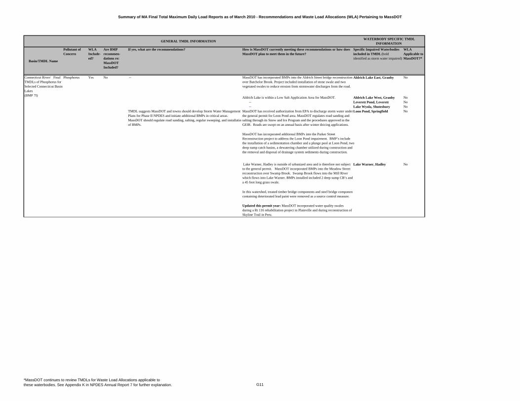
Summary of MA Final Total Maximum Daily Load Reports as of March 2010 - Recommendations and Waste Load Allocations (WLA) Pertaining to MassDOT
Basin/TMDL Name
Pollutant of Concern
WLA Include-ed?
Are BMP recommen-dations re: MassDOT Included?
If yes, what are the recommendations? How is MassDOT currently meeting these recommendations or how does MassDOT plan to meet them in the future?
Specific Impaired Waterbodies included in TMDL (bold identified as storm water impaired)
WLA Applicable to MassDOT?*
GENERAL TMDL INFORMATION WATERBODY SPECIFIC TMDL
INFORMATION
Phosphorus Yes No -- MassDOT has incorporated BMPs into the Aldrich Street bridge reconstruction over Batchelor Brook. Project included installation of stone swale and two vegetated swales to reduce erosion from stormwater discharges from the road.
Aldrich Lake East, Granby No
Aldrich Lake is within a Low Salt Application Area for MassDOT. Aldrich Lake West, Granby No-- Leverett Pond, Leverett No-- Lake Wyola, Shutesbury No
TMDL suggests MassDOT and towns should develop Storm Water Management Plans for Phase II NPDES and initiate additional BMPs in critical areas. MassDOT should regulate road sanding, salting, regular sweeping, and installationof BMPs.
MassDOT has received authorization from EPA to discharge storm water under the general permit for Loon Pond area. MassDOT regulates road sanding and salting through its Snow and Ice Program and the procedures approved in the GEIR. Roads are swept on an annual basis after winter deicing applications.
No
MassDOT has incorporated additional BMPs into the Parker Street Reconstruction project to address the Loon Pond impairment. BMP’s include the installation of a sedimentation chamber and a plunge pool at Loon Pond, two deep sump catch basins, a dewatering chamber utilized during construction and the removal and disposal of drainage system sediments during construction.
Lake Warner, Hadley is outside of urbanized area and is therefore not subject to the general permit. MassDOT incorporated BMPs into the Meadow Street reconstruction over Swamp Brook. Swamp Brook flows into the Mill River which flows into Lake Warner. BMPs installed included 2 deep sump CB’s and a 45 foot long grass swale.
Lake Warner, Hadley No
In this watershed, treated timber bridge components and steel bridge componencontaining deteriorated lead paint were removed as a source control measure.
Updated this permit year: MassDOT incorporated water quality swales during a Rt 116 rehabilitation project in Plainville and during reconstruction of Skyline Trail in Peru.
Connecticut River/ Final TMDLs of Phosphorus for Selected Connecticut Basin Lakes (BMP 7I)
Loon Pond, Springfield
*MassDOT continues to review TMDLs for Waste Load Allocations applicable to these waterbodies. See Appendix K in NPDES Annual Report 7 for further explanation. G11
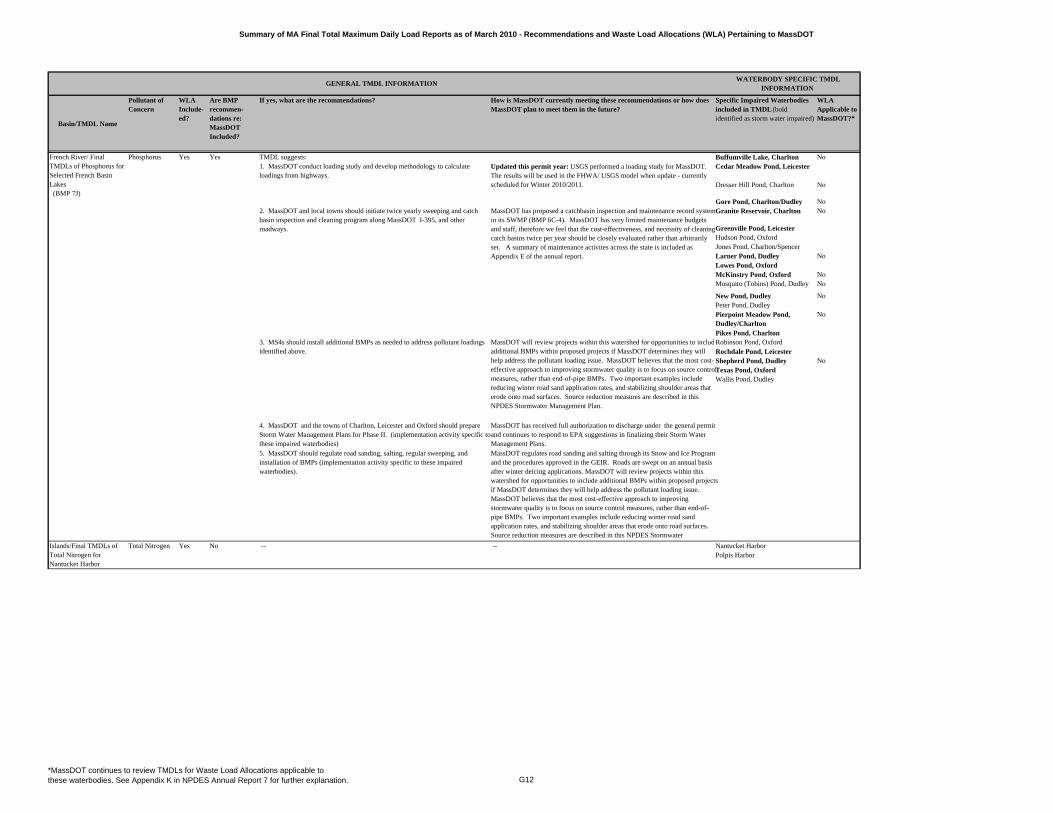
Summary of MA Final Total Maximum Daily Load Reports as of March 2010 - Recommendations and Waste Load Allocations (WLA) Pertaining to MassDOT
Basin/TMDL Name
Pollutant of Concern
WLA Include-ed?
Are BMP recommen-dations re: MassDOT Included?
If yes, what are the recommendations? How is MassDOT currently meeting these recommendations or how does MassDOT plan to meet them in the future?
Specific Impaired Waterbodies included in TMDL (bold identified as storm water impaired)
WLA Applicable to MassDOT?*
GENERAL TMDL INFORMATION WATERBODY SPECIFIC TMDL
INFORMATION
Phosphorus Yes Yes TMDL suggests: Buffumville Lake, Charlton NoCedar Meadow Pond, Leicester
Dresser Hill Pond, Charlton No
Gore Pond, Charlton/Dudley NoGranite Reservoir, Charlton No
Greenville Pond, LeicesterHudson Pond, OxfordJones Pond, Charlton/SpencerLarner Pond, Dudley NoLowes Pond, OxfordMcKinstry Pond, Oxford NoMosquito (Tobins) Pond, Dudley No
New Pond, Dudley NoPeter Pond, DudleyPierpoint Meadow Pond, Dudley/Charlton
No
Pikes Pond, CharltonRobinson Pond, OxfordRochdale Pond, LeicesterShepherd Pond, Dudley NoTexas Pond, OxfordWallis Pond, Dudley
Total Nitrogen Yes No -- -- Nantucket HarborPolpis Harbor
1. MassDOT conduct loading study and develop methodology to calculate loadings from highways.
Updated this permit year: USGS performed a loading study for MassDOT. The results will be used in the FHWA/ USGS model when update - currently scheduled for Winter 2010/2011.
2. MassDOT and local towns should initiate twice yearly sweeping and catch basin inspection and cleaning program along MassDOT I-395, and other roadways.
MassDOT has proposed a catchbasin inspection and maintenance record system in its SWMP (BMP 6C-4). MassDOT has very limited maintenance budgets and staff, therefore we feel that the cost-effectiveness, and necessity of cleaning catch basins twice per year should be closely evaluated rather than arbitrarily set. A summary of maintenance activites across the state is included as Appendix E of the annual report.
French River/ Final TMDLs of Phosphorus for Selected French Basin Lakes (BMP 7J)
Islands/Final TMDLs of Total Nitrogen for Nantucket Harbor
3. MS4s should install additional BMPs as needed to address pollutant loadings identified above.
MassDOT will review projects within this watershed for opportunities to includadditional BMPs within proposed projects if MassDOT determines they will help address the pollutant loading issue. MassDOT believes that the most cost-effective approach to improving stormwater quality is to focus on source control measures, rather than end-of-pipe BMPs. Two important examples include reducing winter road sand application rates, and stabilizing shoulder areas that erode onto road surfaces. Source reduction measures are described in this NPDES Stormwater Management Plan.
4. MassDOT and the towns of Charlton, Leicester and Oxford should prepare Storm Water Management Plans for Phase II. (implementation activity specific to these impaired waterbodies)
MassDOT has received full authorization to discharge under the general permit and continues to respond to EPA suggestions in finalizing their Storm Water Management Plans.
5. MassDOT should regulate road sanding, salting, regular sweeping, and installation of BMPs (implementation activity specific to these impaired waterbodies).
MassDOT regulates road sanding and salting through its Snow and Ice Program and the procedures approved in the GEIR. Roads are swept on an annual basis after winter deicing applications. MassDOT will review projects within this watershed for opportunities to include additional BMPs within proposed projects if MassDOT determines they will help address the pollutant loading issue. MassDOT believes that the most cost-effective approach to improving stormwater quality is to focus on source control measures, rather than end-of-pipe BMPs. Two important examples include reducing winter road sand application rates, and stabilizing shoulder areas that erode onto road surfaces. Source reduction measures are described in this NPDES Stormwater
*MassDOT continues to review TMDLs for Waste Load Allocations applicable to these waterbodies. See Appendix K in NPDES Annual Report 7 for further explanation. G12
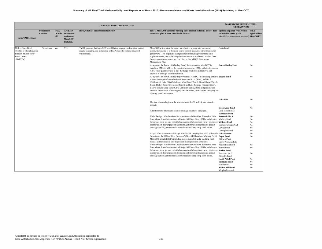
Summary of MA Final Total Maximum Daily Load Reports as of March 2010 - Recommendations and Waste Load Allocations (WLA) Pertaining to MassDOT
Basin/TMDL Name
Pollutant of Concern
WLA Include-ed?
Are BMP recommen-dations re: MassDOT Included?
If yes, what are the recommendations? How is MassDOT currently meeting these recommendations or how does MassDOT plan to meet them in the future?
Specific Impaired Waterbodies included in TMDL (bold identified as storm water impaired)
WLA Applicable to MassDOT?*
GENERAL TMDL INFORMATION WATERBODY SPECIFIC TMDL
INFORMATION
Millers River/Final TMDLs of Phosphorus for Selected Millers River Basin Lakes (BMP 7M)
Phosphorus Yes Yes TMDL suggests that MassDOT should better manage road sanding, salting, regular sweeping, and installation of BMPs (specific to these impaired waterbodies).
MassDOT believes that the most cost-effective approach to improving stormwater quality is to focus on source control measures, rather than end-of-pipe BMPs. Two important examples include reducing winter road sand application rates, and stabilizing shoulder areas that erode onto road surfaces. Source reduction measures are described in this NPDES Stormwater Management Plan.
Bents Pond
As a part of the Route 101 (Dudley Road) Reconstruction, MassDOT is installing BMPs to address the impaired waterbody. BMPs include deep sump CB’s, water quality swales at new discharge locations; and removal and disposal of drainage system sediments.
Bourn-Hadley Pond No
As a part of the Route 2 Safety Improvements, MassDOT is installing BMPs to address the impaired waterbodies of Reservoir No. 1 (Athol) and No. 2 (Phillipston), Lake Ellis (Athol) and Ward Pond (Athol), Brazell Pond (Athol); Bourn-Hadley Pond; Greenwood Pond 2 and Lake Rohunta (Orange/Athol). BMP’s include Deep Sump CB’s, Detention Basins, stone and grass swales, removal and disposal of drainage system sediments, annual street sweeping, and cleaning paved waterways.
Brazell Pond No
Lake Ellis NoThe low salt area begins at the intersection of Rte 32 and 2A, and extends easterly.
Greenwood Pond NoAdded stone to ditches and cleaned drainage structures and pipes. Lake Monomonac
Ramsdall PondReservoir No. 1 NoWallace Pond NoWhitney Pond NoBeaver Flowage Pond NoCowee Pond NoDavenport Pond NoLake Denison NoDepot Pond NoHilchey PondLower Naukeag LakeMinott Pond South NoMinott Pond NoParker PondReservoir No. 2 NoRiceville PondSouth Athol Pond NoStoddard Pond NoWard Pond NoWhites Mill Pond NoWrights Reservoir
As part of reconstruction of Bridge # W-39-018 carrying Route 202 (Glen AllenStreet) over the Millers River (between Whites Mill Pond and Whitney Pond), MassDOT installed BMPs including a deep sump CB and 2 leaching catch basins; and the removal and disposal of drainage system sediments. Under Design: Winchendon - Reconstruction of GlenAllen Street (Rte 202) from Maple Street Intersection to Rindge, NH State Line; BMPs includes the following: stone for pipe ends (help prevent outfall erosion): energy dissipaters at other select discharge points (consisting of stone lined sumps and pads at drainage outfalls); stone stabilization slopes and deep sump catch basins.
Under Design: Winchendon - Reconstruction of GlenAllen Street (Rte 202) from Maple Street Intersection to Rindge, NH State Line; BMPs includes the following: stone for pipe ends (help prevent outfall erosion): energy dissipaters at other select discharge points (consisting of stone lined sumps and pads at drainage outfalls); stone stabilization slopes and deep sump catch basins.
*MassDOT continues to review TMDLs for Waste Load Allocations applicable to these waterbodies. See Appendix K in NPDES Annual Report 7 for further explanation. G13
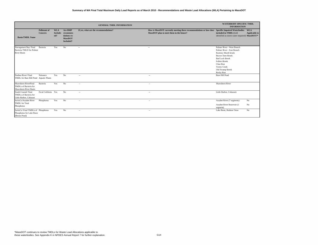
Summary of MA Final Total Maximum Daily Load Reports as of March 2010 - Recommendations and Waste Load Allocations (WLA) Pertaining to MassDOT
Basin/TMDL Name
Pollutant of Concern
WLA Include-ed?
Are BMP recommen-dations re: MassDOT Included?
If yes, what are the recommendations? How is MassDOT currently meeting these recommendations or how does MassDOT plan to meet them in the future?
Specific Impaired Waterbodies included in TMDL (bold identified as storm water impaired)
WLA Applicable to MassDOT?*
GENERAL TMDL INFORMATION WATERBODY SPECIFIC TMDL
INFORMATION
Bacteria Yes -- -- Palmer River - West BranchPalmer River - East BranchRumney Marsh brookBeaver Dam BrookBad Luck BrookFullers BrookClear RunTorrey CreekOld Swamp BrookRocky Run
Nashua River/ Final TMDL for Bare Hill Pond
Nuisance Aquatic Plants
Yes No -- -- Bare Hill Pond
Shawsheen River/Final TMDLs of Bacteria for Shawsheen River Basin
Bacteria Yes No -- -- Shawsheen River
South Coastal/ Final TMDLs of Bacteria for Little Harbor, Cohasset
Fecal Coliform Yes No -- -- Little Harbor, Cohassett
Phosphorus Yes No -- -- Assabet River (7 segments) No
Assabet River Reservoir (1 segment)
No
SuAsCo/ Final TMDLs of Phosphorus for Lake Boon (Boons Pond)
Phosphorus Yes No -- -- Lake Boon, Hudson/ Stow No
Narragansett Bay/ Final Bacteria TMLD for Palmer River Basin
No
SuAsCo/Assabet River TMDL for Total Phosphorus
*MassDOT continues to review TMDLs for Waste Load Allocations applicable to these waterbodies. See Appendix K in NPDES Annual Report 7 for further explanation. G14

NPDES Storm Water Management Plan Annual Report – Permit Year 7
Appendix H: Active MassDOT Construction NOIs in Permit Year 7
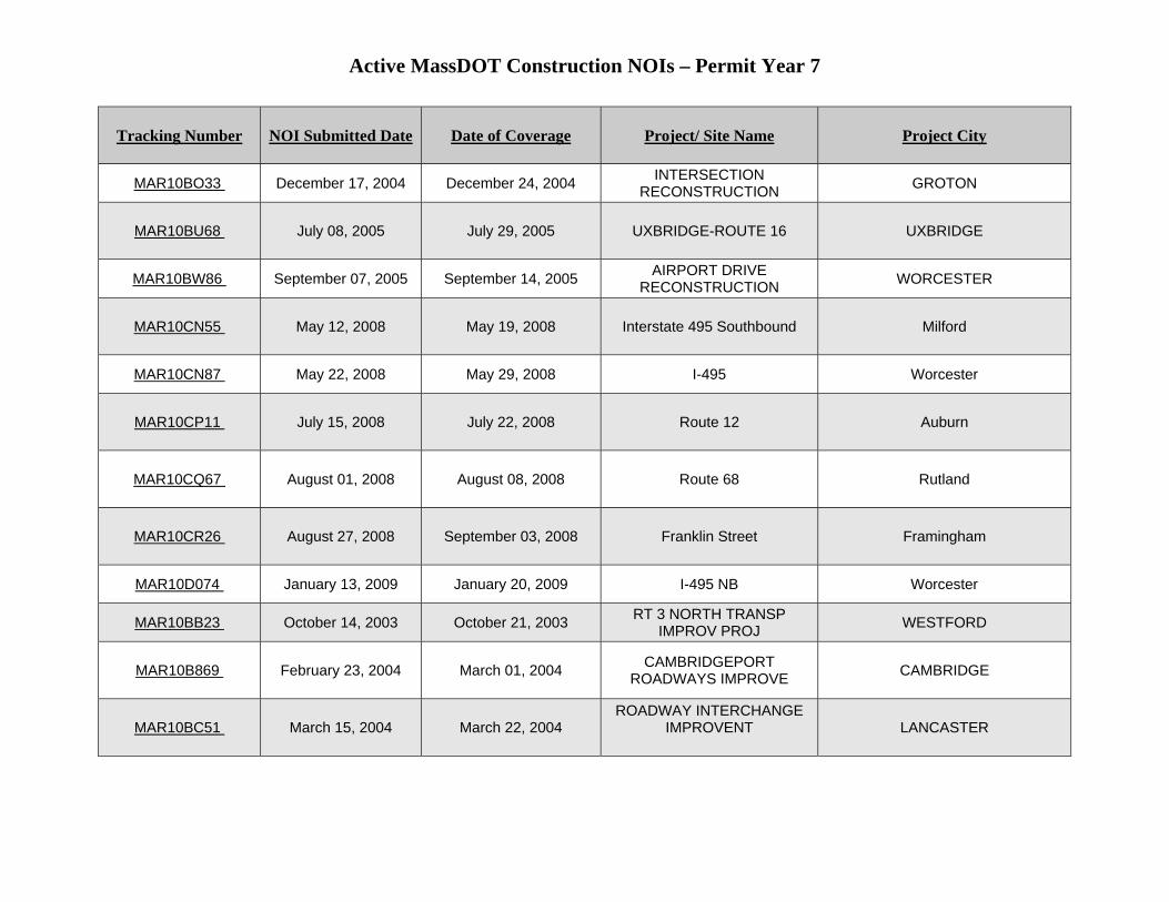
Active MassDOT Construction NOIs – Permit Year 7
Tracking Number NOI Submitted Date Date of Coverage Project/ Site Name Project City
MAR10BO33 December 17, 2004 December 24, 2004 INTERSECTION RECONSTRUCTION GROTON
MAR10BU68 July 08, 2005 July 29, 2005 UXBRIDGE-ROUTE 16 UXBRIDGE
MAR10BW86 September 07, 2005 September 14, 2005 AIRPORT DRIVE RECONSTRUCTION WORCESTER
MAR10CN55 May 12, 2008 May 19, 2008 Interstate 495 Southbound Milford
MAR10CN87 May 22, 2008 May 29, 2008 I-495 Worcester
MAR10CP11 July 15, 2008 July 22, 2008 Route 12 Auburn
MAR10CQ67 August 01, 2008 August 08, 2008 Route 68 Rutland
MAR10CR26 August 27, 2008 September 03, 2008 Franklin Street Framingham
MAR10D074 January 13, 2009 January 20, 2009 I-495 NB Worcester
MAR10BB23 October 14, 2003 October 21, 2003 RT 3 NORTH TRANSP IMPROV PROJ WESTFORD
MAR10B869 February 23, 2004 March 01, 2004 CAMBRIDGEPORT ROADWAYS IMPROVE CAMBRIDGE
MAR10BC51 March 15, 2004 March 22, 2004 ROADWAY INTERCHANGE
IMPROVENT
LANCASTER
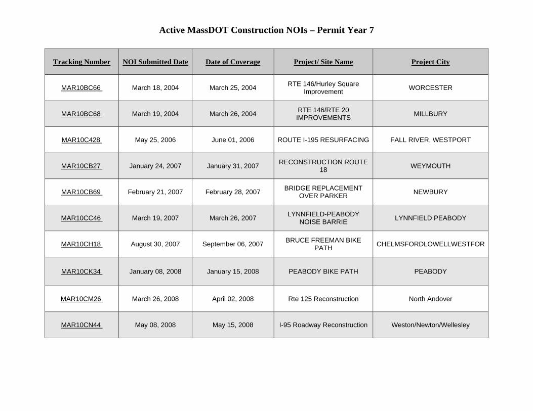
Active MassDOT Construction NOIs – Permit Year 7
Tracking Number NOI Submitted Date Date of Coverage Project/ Site Name Project City
MAR10BC66 March 18, 2004 March 25, 2004 RTE 146/Hurley Square Improvement WORCESTER
MAR10BC68 March 19, 2004 March 26, 2004 RTE 146/RTE 20 IMPROVEMENTS MILLBURY
MAR10C428 May 25, 2006 June 01, 2006 ROUTE I-195 RESURFACING FALL RIVER, WESTPORT
MAR10CB27 January 24, 2007 January 31, 2007 RECONSTRUCTION ROUTE 18 WEYMOUTH
MAR10CB69 February 21, 2007 February 28, 2007 BRIDGE REPLACEMENT OVER PARKER NEWBURY
MAR10CC46 March 19, 2007 March 26, 2007 LYNNFIELD-PEABODY NOISE BARRIE LYNNFIELD PEABODY
MAR10CH18 August 30, 2007 September 06, 2007 BRUCE FREEMAN BIKE PATH CHELMSFORDLOWELLWESTFOR
MAR10CK34 January 08, 2008 January 15, 2008 PEABODY BIKE PATH PEABODY
MAR10CM26 March 26, 2008 April 02, 2008 Rte 125 Reconstruction North Andover
MAR10CN44 May 08, 2008 May 15, 2008 I-95 Roadway Reconstruction Weston/Newton/Wellesley
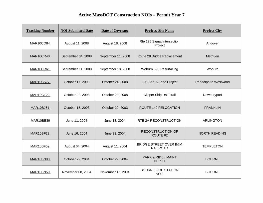
Active MassDOT Construction NOIs – Permit Year 7
Tracking Number NOI Submitted Date Date of Coverage Project/ Site Name Project City
MAR10CQ84 August 11, 2008 August 18, 2008 Rte 125 Signal/Intersection Project Andover
MAR10CR40 September 04, 2008 September 11, 2008 Route 28 Bridge Replacement Methuen
MAR10CR61 September 11, 2008 September 18, 2008 Woburn I-95 Resurfacing Woburn
MAR10CS77 October 17, 2008 October 24, 2008 I-95 Add-A-Lane Project Randolph to Westwood
MAR10CT22 October 22, 2008 October 29, 2008 Clipper Ship Rail Trail Newburyport
MAR10BJ51 October 15, 2003 October 22, 2003 ROUTE 140 RELOCATION FRANKLIN
MAR10BE89 June 11, 2004 June 18, 2004 RTE 2A RECONSTRUCTION ARLINGTON
MAR10BF22 June 16, 2004 June 23, 2004 RECONSTRUCTION OF ROUTE 62 NORTH READING
MAR10BF59 August 04, 2004 August 11, 2004 BRIDGE STREET OVER B&M RAILROAD TEMPLETON
MAR10BN00 October 22, 2004 October 29, 2004 PARK & RIDE / MAINT DEPOT BOURNE
MAR10BN50 November 08, 2004 November 15, 2004 BOURNE FIRE STATION NO.3 BOURNE
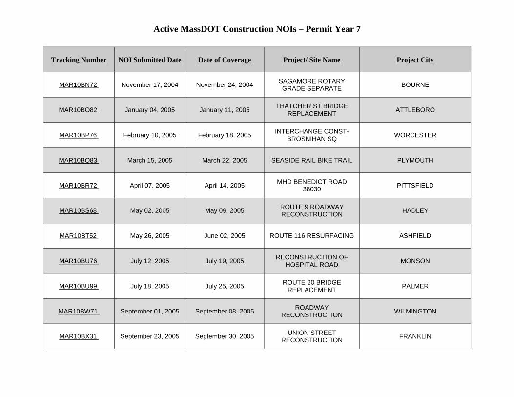
Active MassDOT Construction NOIs – Permit Year 7
Tracking Number NOI Submitted Date Date of Coverage Project/ Site Name Project City
MAR10BN72 November 17, 2004 November 24, 2004 SAGAMORE ROTARY GRADE SEPARATE BOURNE
MAR10BO82 January 04, 2005 January 11, 2005 THATCHER ST BRIDGE REPLACEMENT ATTLEBORO
MAR10BP76 February 10, 2005 February 18, 2005 INTERCHANGE CONST-BROSNIHAN SQ WORCESTER
MAR10BQ83 March 15, 2005 March 22, 2005 SEASIDE RAIL BIKE TRAIL PLYMOUTH
MAR10BR72 April 07, 2005 April 14, 2005 MHD BENEDICT ROAD 38030 PITTSFIELD
MAR10BS68 May 02, 2005 May 09, 2005 ROUTE 9 ROADWAY RECONSTRUCTION HADLEY
MAR10BT52 May 26, 2005 June 02, 2005 ROUTE 116 RESURFACING ASHFIELD
MAR10BU76 July 12, 2005 July 19, 2005 RECONSTRUCTION OF HOSPITAL ROAD MONSON
MAR10BU99 July 18, 2005 July 25, 2005 ROUTE 20 BRIDGE REPLACEMENT PALMER
MAR10BW71 September 01, 2005 September 08, 2005 ROADWAY RECONSTRUCTION WILMINGTON
MAR10BX31 September 23, 2005 September 30, 2005 UNION STREET RECONSTRUCTION FRANKLIN
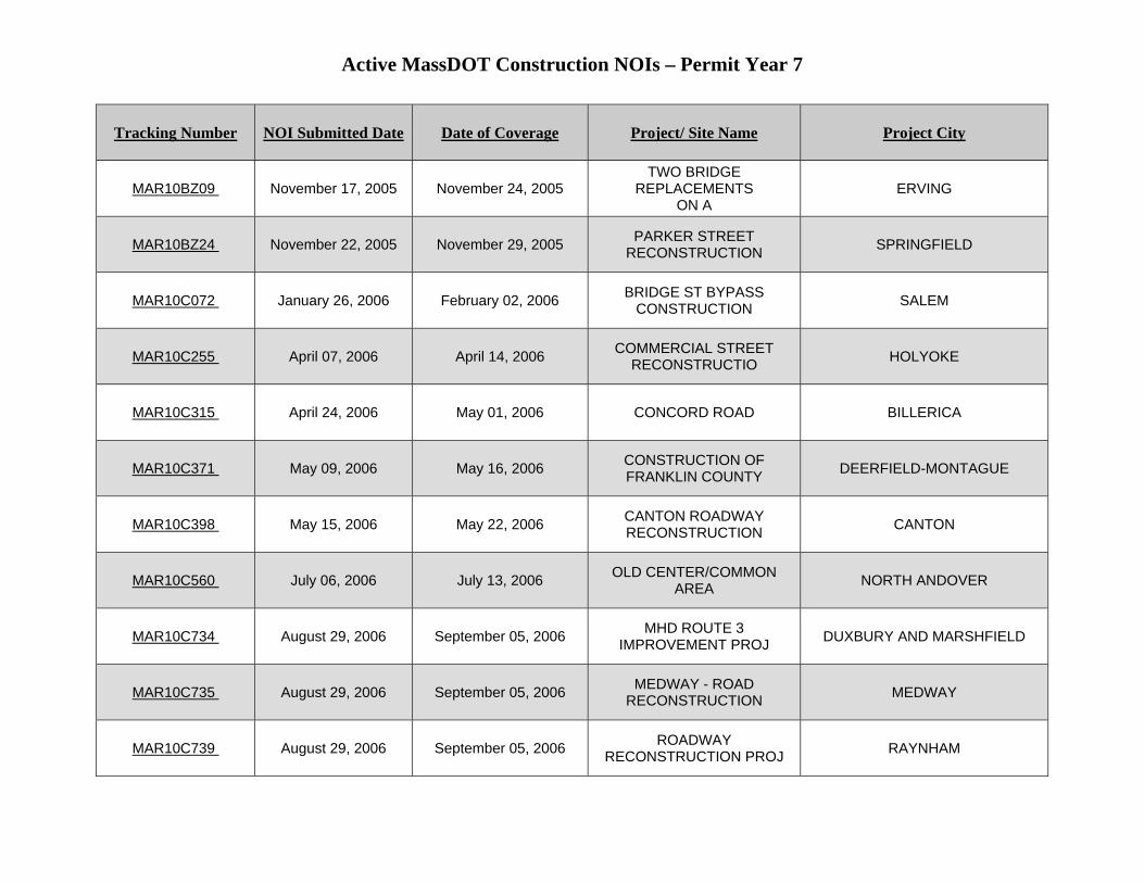
Active MassDOT Construction NOIs – Permit Year 7
Tracking Number NOI Submitted Date Date of Coverage Project/ Site Name Project City
MAR10BZ09 November 17, 2005 November 24, 2005 TWO BRIDGE
REPLACEMENTS ON A
ERVING
MAR10BZ24 November 22, 2005 November 29, 2005 PARKER STREET RECONSTRUCTION SPRINGFIELD
MAR10C072 January 26, 2006 February 02, 2006 BRIDGE ST BYPASS CONSTRUCTION SALEM
MAR10C255 April 07, 2006 April 14, 2006 COMMERCIAL STREET RECONSTRUCTIO HOLYOKE
MAR10C315 April 24, 2006 May 01, 2006 CONCORD ROAD BILLERICA
MAR10C371 May 09, 2006 May 16, 2006 CONSTRUCTION OF FRANKLIN COUNTY DEERFIELD-MONTAGUE
MAR10C398 May 15, 2006 May 22, 2006 CANTON ROADWAY RECONSTRUCTION CANTON
MAR10C560 July 06, 2006 July 13, 2006 OLD CENTER/COMMON AREA NORTH ANDOVER
MAR10C734 August 29, 2006 September 05, 2006 MHD ROUTE 3 IMPROVEMENT PROJ DUXBURY AND MARSHFIELD
MAR10C735 August 29, 2006 September 05, 2006 MEDWAY - ROAD RECONSTRUCTION MEDWAY
MAR10C739 August 29, 2006 September 05, 2006 ROADWAY RECONSTRUCTION PROJ RAYNHAM
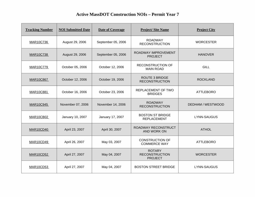
Active MassDOT Construction NOIs – Permit Year 7
Tracking Number NOI Submitted Date Date of Coverage Project/ Site Name Project City
MAR10C736 August 29, 2006 September 05, 2006 ROADWAY RECONSTRUCTION WORCESTER
MAR10C738 August 29, 2006 September 05, 2006 ROADWAY IMPROVEMENT PROJECT HANOVER
MAR10C779 October 05, 2006 October 12, 2006 RECONSTRUCTION OF MAIN ROAD GILL
MAR10C867 October 12, 2006 October 19, 2006 ROUTE 3 BRIDGE RECONSTRUCTION ROCKLAND
MAR10C881 October 16, 2006 October 23, 2006 REPLACEMENT OF TWO BRIDGES ATTLEBORO
MAR10C945 November 07, 2006 November 14, 2006 ROADWAY RECONSTRUCTION DEDHAM / WESTWOOD
MAR10CB02 January 10, 2007 January 17, 2007 BOSTON ST BRIDGE REPLACEMENT LYNN-SAUGUS
MAR10CD40 April 23, 2007 April 30, 2007 ROADWAY RECONSTRUCT AND WORK ON ATHOL
MAR10CD49 April 26, 2007 May 03, 2007 CONSTRUCTION OF COMMERCE WAY ATTLEBORO
MAR10CD52 April 27, 2007 May 04, 2007 ROTARY
RECONSTRUCTION PROJECT
WORCESTER
MAR10CD53 April 27, 2007 May 04, 2007 BOSTON STREET BRIDGE LYNN-SAUGUS
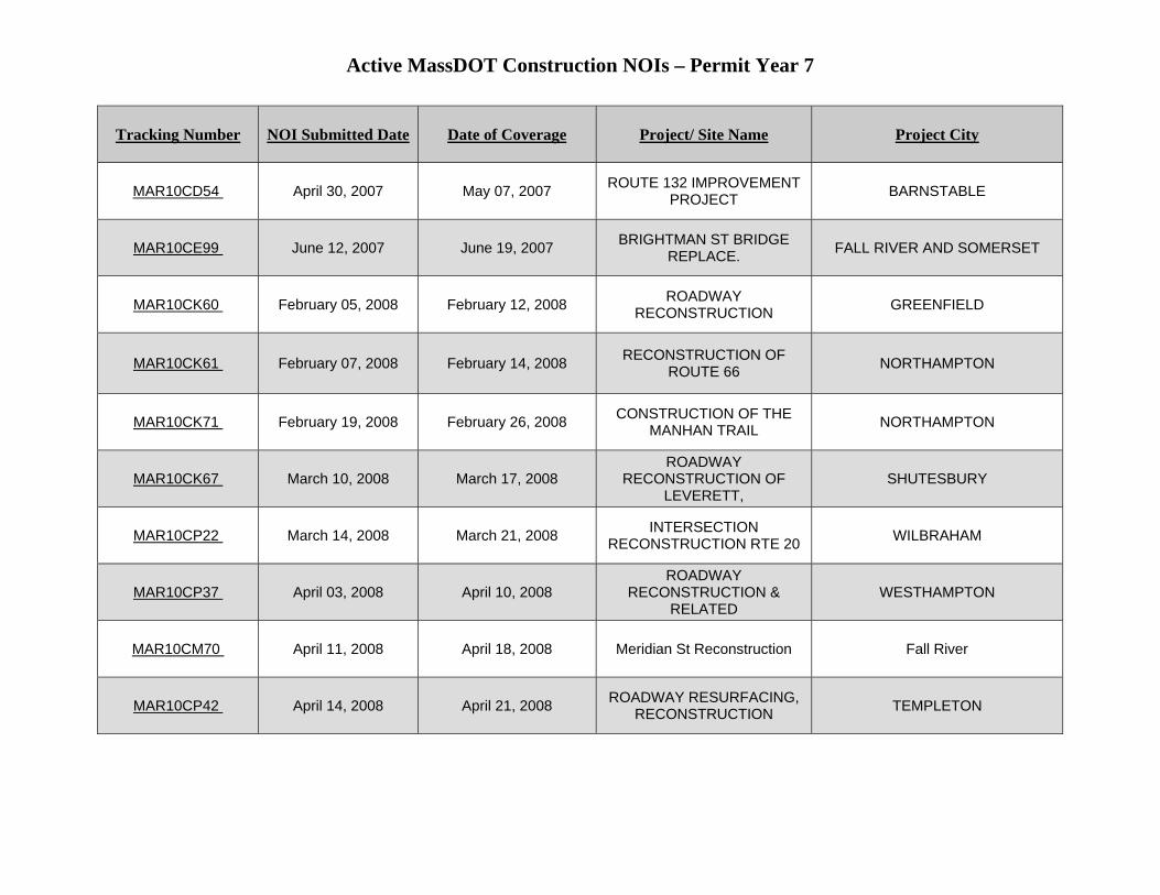
Active MassDOT Construction NOIs – Permit Year 7
Tracking Number NOI Submitted Date Date of Coverage Project/ Site Name Project City
MAR10CD54 April 30, 2007 May 07, 2007 ROUTE 132 IMPROVEMENT PROJECT BARNSTABLE
MAR10CE99 June 12, 2007 June 19, 2007 BRIGHTMAN ST BRIDGE REPLACE. FALL RIVER AND SOMERSET
MAR10CK60 February 05, 2008 February 12, 2008 ROADWAY RECONSTRUCTION GREENFIELD
MAR10CK61 February 07, 2008 February 14, 2008 RECONSTRUCTION OF ROUTE 66 NORTHAMPTON
MAR10CK71 February 19, 2008 February 26, 2008 CONSTRUCTION OF THE MANHAN TRAIL NORTHAMPTON
MAR10CK67 March 10, 2008 March 17, 2008 ROADWAY
RECONSTRUCTION OF LEVERETT,
SHUTESBURY
MAR10CP22 March 14, 2008 March 21, 2008 INTERSECTION RECONSTRUCTION RTE 20 WILBRAHAM
MAR10CP37 April 03, 2008 April 10, 2008 ROADWAY
RECONSTRUCTION & RELATED
WESTHAMPTON
MAR10CM70 April 11, 2008 April 18, 2008 Meridian St Reconstruction Fall River
MAR10CP42 April 14, 2008 April 21, 2008 ROADWAY RESURFACING, RECONSTRUCTION TEMPLETON

Active MassDOT Construction NOIs – Permit Year 7
Tracking Number NOI Submitted Date Date of Coverage Project/ Site Name Project City
MAR10CM74 April 22, 2008 April 29, 2008 Interstate 495 Reconstruction Raynham-Middleboro
MAR10CM92 April 22, 2008 April 29, 2008 Intersection Reconstruction Orleans
MAR10CP70 May 13, 2008 May 20, 2008 ROUTE 47 BRIDGE S-18-007 HADLEY ST SOUTH HADLEY
MAR10CP85 May 27, 2008 June 03, 2008 ROADWAY RESURFACING & RECONSTRUCTION PELHAM/ BELCHERTOWN
MAR10CP91 May 29, 2008 June 05, 2008 SOUTHWICK RAIL TRAIL CONSTRUCTION SOUTHWICK
MAR10CP90 May 29, 2008 June 05, 2008 BRIDGE REPLACEMENT(O-03-21) STEEL ORANGE
MAR10CP89 May 29, 2008 June 05, 2008 INTERSECTION
RECONSTRUCTION AT PAGE
SPRINGFIELD
MAR10CP64 June 11, 2008 July 20, 2008 ROADWAY RECONSTRUCTION 53234 DALTON
MAR10CO39 June 16, 2008 June 23, 2008 Mattapoisett Bikepath Ph 1A Mattapoisett
MAR10CO40 June 16, 2008 June 23, 2008 Swan River Rd Reconstruction Dennis
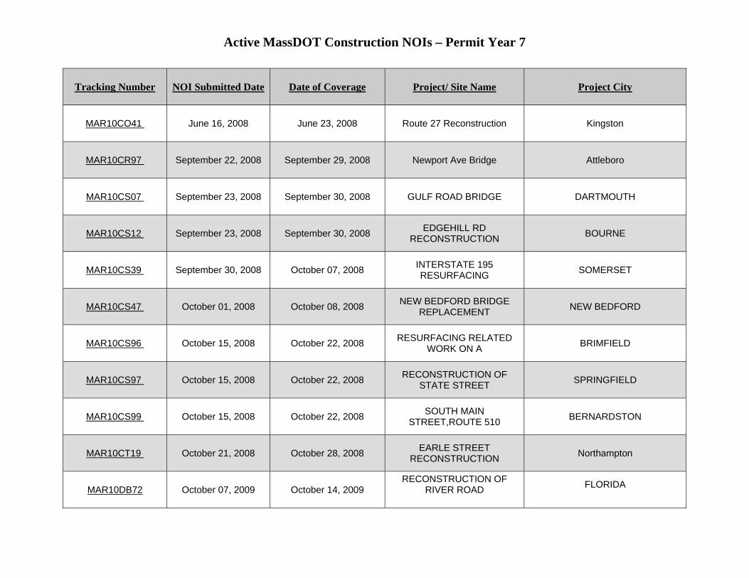
Active MassDOT Construction NOIs – Permit Year 7
Tracking Number NOI Submitted Date Date of Coverage Project/ Site Name Project City
MAR10CO41 June 16, 2008 June 23, 2008 Route 27 Reconstruction Kingston
MAR10CR97 September 22, 2008 September 29, 2008 Newport Ave Bridge Attleboro
MAR10CS07 September 23, 2008 September 30, 2008 GULF ROAD BRIDGE DARTMOUTH
MAR10CS12 September 23, 2008 September 30, 2008 EDGEHILL RD RECONSTRUCTION BOURNE
MAR10CS39 September 30, 2008 October 07, 2008 INTERSTATE 195 RESURFACING SOMERSET
MAR10CS47 October 01, 2008 October 08, 2008 NEW BEDFORD BRIDGE REPLACEMENT NEW BEDFORD
MAR10CS96 October 15, 2008 October 22, 2008 RESURFACING RELATED WORK ON A BRIMFIELD
MAR10CS97 October 15, 2008 October 22, 2008 RECONSTRUCTION OF STATE STREET SPRINGFIELD
MAR10CS99 October 15, 2008 October 22, 2008 SOUTH MAIN STREET,ROUTE 510 BERNARDSTON
MAR10CT19 October 21, 2008 October 28, 2008 EARLE STREET RECONSTRUCTION Northampton
MAR10DB72 October 07, 2009 October 14, 2009 RECONSTRUCTION OF
RIVER ROAD
FLORIDA
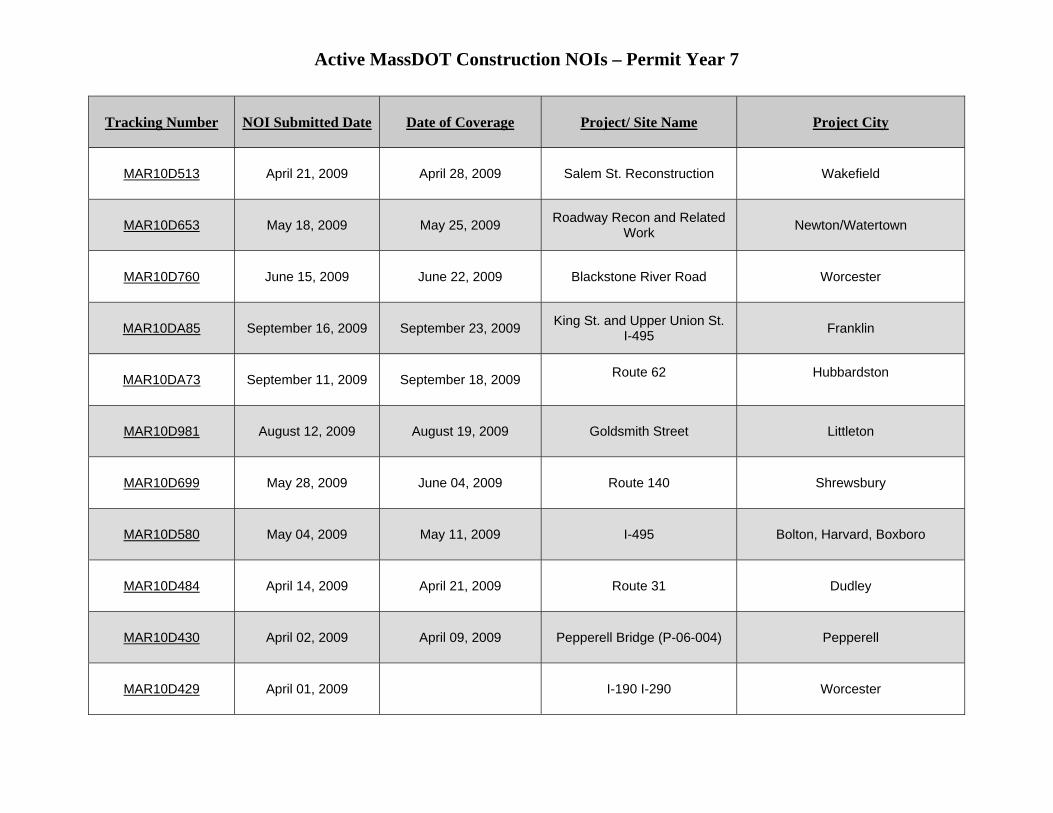
Active MassDOT Construction NOIs – Permit Year 7
Tracking Number NOI Submitted Date Date of Coverage Project/ Site Name Project City
MAR10D513 April 21, 2009 April 28, 2009 Salem St. Reconstruction Wakefield
MAR10D653 May 18, 2009 May 25, 2009 Roadway Recon and Related Work Newton/Watertown
MAR10D760 June 15, 2009 June 22, 2009 Blackstone River Road Worcester
MAR10DA85 September 16, 2009 September 23, 2009 King St. and Upper Union St. I-495 Franklin
MAR10DA73 September 11, 2009 September 18, 2009 Route 62
Hubbardston
MAR10D981 August 12, 2009 August 19, 2009 Goldsmith Street Littleton
MAR10D699 May 28, 2009 June 04, 2009 Route 140 Shrewsbury
MAR10D580 May 04, 2009 May 11, 2009 I-495 Bolton, Harvard, Boxboro
MAR10D484 April 14, 2009 April 21, 2009 Route 31 Dudley
MAR10D430 April 02, 2009 April 09, 2009 Pepperell Bridge (P-06-004) Pepperell
MAR10D429 April 01, 2009 I-190 I-290 Worcester
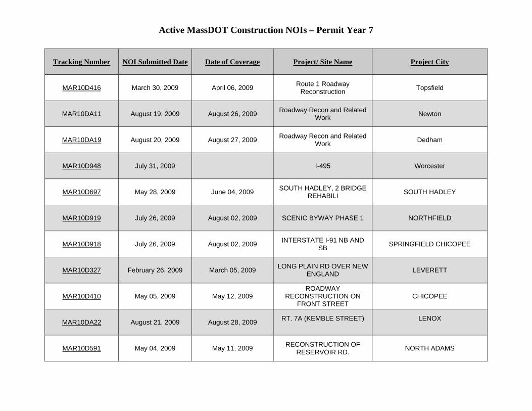
Active MassDOT Construction NOIs – Permit Year 7
Tracking Number NOI Submitted Date Date of Coverage Project/ Site Name Project City
MAR10D416 March 30, 2009 April 06, 2009 Route 1 Roadway Reconstruction Topsfield
MAR10DA11 August 19, 2009 August 26, 2009 Roadway Recon and Related Work Newton
MAR10DA19 August 20, 2009 August 27, 2009 Roadway Recon and Related Work Dedham
MAR10D948 July 31, 2009 I-495 Worcester
MAR10D697 May 28, 2009 June 04, 2009 SOUTH HADLEY, 2 BRIDGE REHABILI SOUTH HADLEY
MAR10D919 July 26, 2009 August 02, 2009 SCENIC BYWAY PHASE 1 NORTHFIELD
MAR10D918 July 26, 2009 August 02, 2009 INTERSTATE I-91 NB AND SB SPRINGFIELD CHICOPEE
MAR10D327 February 26, 2009 March 05, 2009 LONG PLAIN RD OVER NEW ENGLAND LEVERETT
MAR10D410 May 05, 2009 May 12, 2009 ROADWAY
RECONSTRUCTION ON FRONT STREET
CHICOPEE
MAR10DA22 August 21, 2009 August 28, 2009 RT. 7A (KEMBLE STREET)
LENOX
MAR10D591 May 04, 2009 May 11, 2009 RECONSTRUCTION OF RESERVOIR RD. NORTH ADAMS
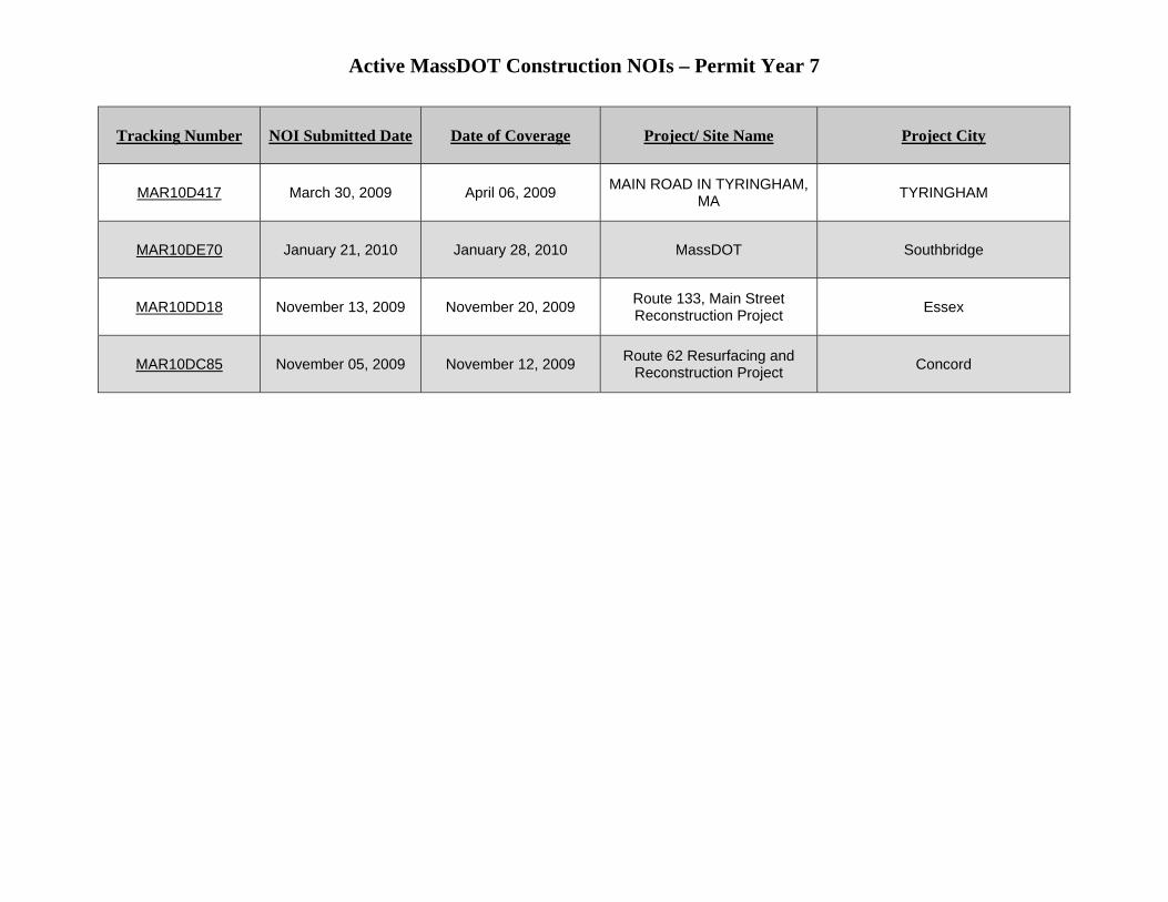
Active MassDOT Construction NOIs – Permit Year 7
Tracking Number NOI Submitted Date Date of Coverage Project/ Site Name Project City
MAR10D417 March 30, 2009 April 06, 2009 MAIN ROAD IN TYRINGHAM, MA TYRINGHAM
MAR10DE70 January 21, 2010 January 28, 2010 MassDOT Southbridge
MAR10DD18 November 13, 2009 November 20, 2009 Route 133, Main Street Reconstruction Project Essex
MAR10DC85 November 05, 2009 November 12, 2009 Route 62 Resurfacing and Reconstruction Project Concord

NPDES Storm Water Management Plan Annual Report – Permit Year 7
Appendix I: Evaluating Highway Runoff’s Effect on Receiving Waters at Three Sites in Massachusetts
Prepared for: MassHighway Department
Evaluating Highway Runoff’s Effect on Receiving Waters at Three Sites in Massachusetts
AECOM, Inc. October 2009 Document No.: 04489-015-0801

AECOM Environment
i October 2009 J:\Water\ProjectFiles\P40\04489 MHD\04489013 MHD
Contract No. 49700\Assignment 14 CLF Lawsuit Sites WQ Review\Model\USGS\Submittals\Technical Memo final.docx
Contents
1.0 Executive Summary ............................................................................................................................... 1-1
2.0 Subject Sites ........................................................................................................................................... 2-1
2.1 Interstate 495/Charles River Crossing in Bellingham ..................................................................... 2-1
2.2 Interstate 495/Charles River Crossing in Milford ............................................................................ 2-2
2.3 Interstate 190/North Nashua River Crossing in Lancaster ............................................................. 2-3
3.0 FHWA Model Development ................................................................................................................... 3-1
3.1 FHWA Model ................................................................................................................................... 3-1
3.2 VB/Excel Model Development ........................................................................................................ 3-2
3.3 Data Sources ................................................................................................................................... 3-2 3.3.1 Precipitation Data .............................................................................................................. 3-3 3.3.2 Streamflow Data ................................................................................................................ 3-4 3.3.3 Runoff ................................................................................................................................. 3-4 3.3.4 Water Quality Standards ................................................................................................... 3-5 3.3.5 Pollutant Concentration in Runoff Data ............................................................................ 3-6 3.3.6 Watershed Data ................................................................................................................. 3-7 3.3.7 Stormwater Management Infrastructure (BMPs) .............................................................. 3-8
4.0 Evaluation Methodology ....................................................................................................................... 4-1
4.1 External Hydrologic and Hydraulic Evaluation of BMPs ................................................................ 4-1
5.0 Results ..................................................................................................................................................... 5-1
5.1 External Model Application: Determine Runoff Rate Reduction by BMP ...................................... 5-1
5.2 Visual Basic (VB)/ FHWA Model Application .................................................................................. 5-1
6.0 Conclusions ............................................................................................................................................ 6-1
7.0 References .............................................................................................................................................. 7-1
AECOM Environment
ii October 2009 J:\Water\ProjectFiles\P40\04489 MHD\04489013 MHD
Contract No. 49700\Assignment 14 CLF Lawsuit Sites WQ Review\Model\USGS\Submittals\Technical Memo final.docx
List of Tables
Table 2-1. Contributing Watershed to I-495/Charles River Crossing, Bellingham ......................................... 2-2
Table 2-2. Contributing Watershed to I-495/Charles River Crossing, Milford ................................................ 2-3
Table 2-3. Contributing Watershed to MassHighway Outfall at I-190/North Nashua River Crossing, Lancaster................................................................................................................................................... 2-4
Table 3-1. FHWA Model Input Values, Precipitation ....................................................................................... 3-3
Table 3-2. Streamflow Gage References ........................................................................................................ 3-4
Table 3-3 FHWA Model Input Values, Streamflow ......................................................................................... 3-4
Table 3-4 EPA Acute Concentration Criterion Adjusted to Compensate for Background River Concentrations (TH and CTA) ........................................................................................................................... 3-5
Table 3-5 FHWA Input Values, Site Median Concentrations (TCR) .............................................................. 3-6
Table 3-6 Coefficient of Variation of Pollutants in Runoff (CVCR), MassHighway SELDM database .......... 3-6
Table 3-7 FHWA Inputs Values, Soluble Fraction of Pollutant in Highway Runoff (FSOL) .......................... 3-7
Table 3-8 Estimates of the Area of the Right-of-Way (AROW) ...................................................................... 3-8
Table 3-9 Estimates of the Area of the Impervious Highway (AHWY) ........................................................... 3-8
Table 5-1. VB/FHWA Model Results ............................................................................................................... 5-1
Table 7-1. Model Input Variables, Defined .......................................................................................................... 1
Table 7-2. Model Calculations in VB/Excel Version of the FHWA model ........................................................... 2
Table 7-3. Calculating CO .................................................................................................................................... 4
Table 7-4. Input Report, I-495/Charles River Crossing, Milford .......................................................................... 7
Table 7-5. Input Report, I-495/Charles River Crossing, Bellingham .................................................................. 8
Table 7-6. Input Report, I-190/North Nashua River Crossing, Lancaster .......................................................... 9
Table 7-7. Output Report, I-495/Charles River Crossing, Milford ..................................................................... 10
Table 7-8. Output Report, I-495/Charles River Crossing, Bellingham .............................................................. 10
Table 7-9. Output Report, I-190/North Nashua River Crossing, Lancaster ..................................................... 10
AECOM Environment
iii October 2009 J:\Water\ProjectFiles\P40\04489 MHD\04489013 MHD
Contract No. 49700\Assignment 14 CLF Lawsuit Sites WQ Review\Model\USGS\Submittals\Technical Memo final.docx
List of Figures
Figure 1. I-495/Charles River, Bellingham ....................................................................................................... 2-2
Figure 2. I-495/Charles River, Milford ............................................................................................................. 2-3
Figure 3. I-190/North Nashua River, Lancaster............................................................................................... 2-4
Figure 4. Watershed Area, I-495/Charles River, Bellingham .......................................................................... 3-9
Figure 5. BMP, I-495/Charles River, Bellingham .......................................................................................... 3-10
Figure 6. Watershed Area, I-495/Charles River, Milford ............................................................................... 3-11
Figure 7. BMP, I-495/Charles River, Milford .................................................................................................. 3-12
Figure 8. Watershed Area, I-190/North Nashua River, Lancaster ................................................................ 3-13
Figure 9. BMP, I-190/North Nashua River, Lancaster .................................................................................. 3-14
AECOM Environment
1-1 October 2009 J:\Water\ProjectFiles\P40\04489 MHD\04489013 MHD
Contract No. 49700\Assignment 14 CLF Lawsuit Sites WQ Review\Model\USGS\Submittals\Technical Memo final.docx
1.0 Executive Summary
The Findings and Rulings of Civil Action No. 06-11295-WGY requires that MassHighway install Best Management Practices (BMPs) at three stream crossings to address the effect of stormwater runoff on the receiving waters. This requirement was part of compliance with MassHighway’s General Permit for EPA’s National Pollutant Discharge Elimination System (NPDES) for Stormwater Discharges from Municipal Separate Storm Sewer Systems (MS4).
Section I.B.2(k) of the General Permit specifies that MassHighway discharges may not cause or contribute to instream exceedance of water quality standards. Part IX: 401 Water Quality Certification of the general permit indicates that “compliance with conditions of the permit will result in compliance with the applicable water quality standards as required by the Massachusetts Surface Water Quality Standards regulations (314 CMR 4.00) and with 314 CMR 9.04 and that the permittee will be in compliance with Sections 301, 302, 303, 306 and 307 of the Federal Clean Water Act." Specifically, stormwater runoff from MassHighway roads must not cause receiving waters to exceed the EPA Acute Toxicity Criteria. EPA acute toxicity criteria specify the concentration of pollutant that must not be exceeded for a duration of one-hour at the frequency of once in three years, referred to herein as the 1-hour, 3-year concentration. The EPA National Recommended Water Quality Criteria (EPA 822-R-02-047, November 2002) published by the EPA pursuant to Section 304(a) of the Federal Water Pollution Control Act specifies the acute toxicity concentrations of zinc and lead. Massachusetts 314 CMR 4.00 Surface Water Quality Standards, Table 28, Site Specific Criteria, specifies the acute toxicity concentration for copper in the Charles River.
As part of the BMP design to address these sites, MassHighway contracted with AECOM, Inc. to evaluate the effect of highway runoff on the in-stream concentrations of copper, lead, and zinc in the Charles and North Nashua Rivers. The subject sites include:
1. I-495 crossing of the Charles River in Bellingham,
2. I-495 crossing of the Charles River in Milford, and
3. I-190 crossing of the North Nashua River in Lancaster.
AECOM visited each site to evaluate existing field conditions including drainage flow paths, land cover, and stormwater management infrastructure. Then, AECOM adapted an existing numerical model (originally developed by the Federal Highway Administration) to estimate the 3-year peak pollutant concentration in the receiving waters at the subject sites. AECOM compared the estimated 3-year peak pollutant concentrations to the EPA Acute Toxicity Concentrations. AECOM determined that each site had existing stormwater management infrastructure (BMPs), which already provides sufficient retention/detention capacity to eliminate the risk of causing the receiving waters to exceed the EPA acute toxicity criteria and therefore construction of additional BMPs is not warranted.
Section 2.0 provides a detailed description of each subject site including the contributing area, the drainage pathways, and existing stormwater management infrastructure.
Section 3.0 describes the numerical model and lists site characterization values that AECOM used to evaluate each subject site. AECOM adapted a numerical model originally developed by the Federal Highway Administration (FHWA) to predict the 3-year peak pollutant concentration in the receiving water based on the characteristics of the contributing site and the quality of the stormwater runoff.
AECOM Environment
1-2 October 2009 J:\Water\ProjectFiles\P40\04489 MHD\04489013 MHD
Contract No. 49700\Assignment 14 CLF Lawsuit Sites WQ Review\Model\USGS\Submittals\Technical Memo final.docx
Section 4.0 describes the method that AECOM used to evaluate the performance of existing BMPs at the subject sites. This was a necessary step because the numerical model described in Section 3.0 does not account for runoff volume reduction and water quality treatment provided by existing on-site BMPs.
Section 5.0 presents the results of the assessment to determine whether highway runoff from the subject sites causes the receiving waters to exceed EPA’s Acute Toxicity Criteria.
Section 6.0 presents the conclusions of this study. Model results indicate that existing BMPs at the subject sites reduce the impact of highway stormwater runoff on the subject receiving waters. Runoff does not cause the receiving waters to exceed EPA acute toxicity criteria.
Appendix A contains the FHWA model implementation. Appendix B contains model input and output reports.
AECOM Environment
2-1 October 2009 J:\Water\ProjectFiles\P40\04489 MHD\04489013 MHD
Contract No. 49700\Assignment 14 CLF Lawsuit Sites WQ Review\Model\USGS\Submittals\Technical Memo final.docx
2.0 Subject Sites
This section of the report describes the characteristics of the sites evaluated as part of this study. The subject sites include.
1. I-495 crossing of the Charles River in Bellingham
2. I-495 crossing of the Charles River in Milford
3. I-190 crossing of the North Nashua River in Lancaster
AECOM characterized each of the subject sites using information from MassHighway drainage drawings and from site visits conducted during the summer of 2008. During the site visits, AECOM verified the existing contributing drainage area boundaries, land cover, and stormwater management infrastructure.
2.1 Interstate 495/Charles River Crossing in Bellingham
Approximately 20 acres of MassHighway right-of-way drains to the I-495/Charles River crossing in Bellingham. The contributing area is composed primarily of grass and impervious highway. Wetland and forest occupy the remainder of the contributing area. Table 2-1 presents this watershed’s land cover areas and percentages.
At this site, I-495 is divided. The northbound and southbound lanes are each approximately 55 feet wide, including the shoulder. The length of highway corridor contributing to the discharge point is approximately 2000 feet. The site has a BMP consisting of a vegetated swale along the highway median that collects runoff from approximately 53 percent of the total contributing area. Figure 1 illustrates the location of the subject site and the MassHighway property contributing to the crossing and to the site BMP. Section 3.3.7.1 of this report provides a detailed description of the BMP at this site.
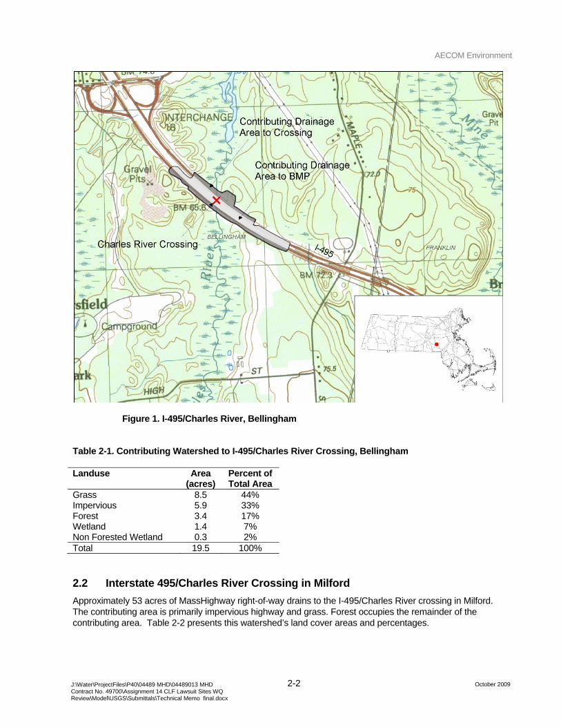
AECOM Environment
2-2 October 2009 J:\Water\ProjectFiles\P40\04489 MHD\04489013 MHD
Contract No. 49700\Assignment 14 CLF Lawsuit Sites WQ Review\Model\USGS\Submittals\Technical Memo final.docx
Figure 1. I-495/Charles River, Bellingham
Table 2-1. Contributing Watershed to I-495/Charles River Crossing, Bellingham
Landuse Area (acres)
Percent of Total Area
Grass 8.5 44% Impervious 5.9 33% Forest 3.4 17% Wetland 1.4 7% Non Forested Wetland 0.3 2% Total 19.5 100%
2.2 Interstate 495/Charles River Crossing in Milford
Approximately 53 acres of MassHighway right-of-way drains to the I-495/Charles River crossing in Milford. The contributing area is primarily impervious highway and grass. Forest occupies the remainder of the contributing area. Table 2-2 presents this watershed’s land cover areas and percentages.
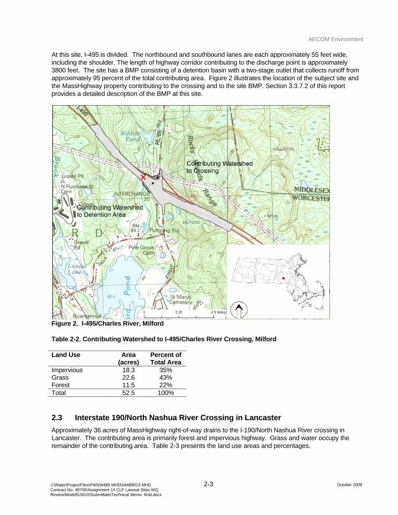
AECOM Environment
2-3 October 2009 J:\Water\ProjectFiles\P40\04489 MHD\04489013 MHD
Contract No. 49700\Assignment 14 CLF Lawsuit Sites WQ Review\Model\USGS\Submittals\Technical Memo final.docx
At this site, I-495 is divided. The northbound and southbound lanes are each approximately 55 feet wide, including the shoulder. The length of highway corridor contributing to the discharge point is approximately 3800 feet. The site has a BMP consisting of a detention basin with a two-stage outlet that collects runoff from approximately 95 percent of the total contributing area. Figure 2 illustrates the location of the subject site and the MassHighway property contributing to the crossing and to the site BMP. Section 3.3.7.2 of this report provides a detailed description of the BMP at this site.
Figure 2. I-495/Charles River, Milford
Table 2-2. Contributing Watershed to I-495/Charles River Crossing, Milford
Land Use Area (acres)
Percent of Total Area
Impervious 18.3 35% Grass 22.6 43% Forest 11.5 22% Total 52.5 100%
2.3 Interstate 190/North Nashua River Crossing in Lancaster
Approximately 36 acres of MassHighway right-of-way drains to the I-190/North Nashua River crossing in Lancaster. The contributing area is primarily forest and impervious highway. Grass and water occupy the remainder of the contributing area. Table 2-3 presents the land use areas and percentages.
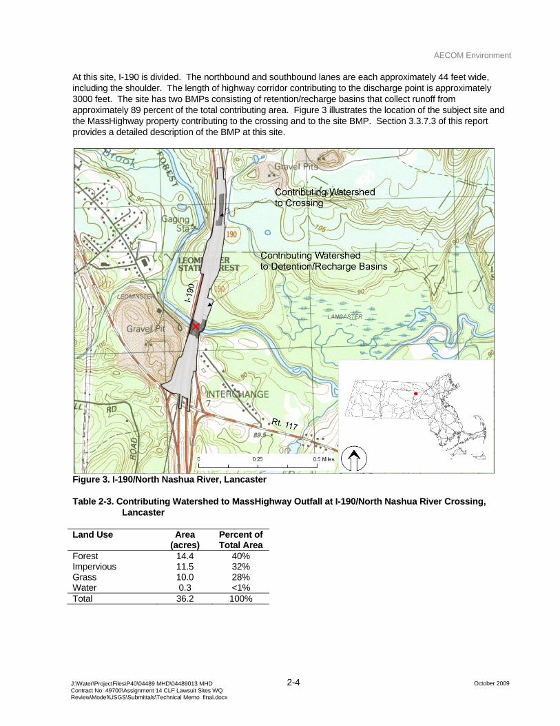
AECOM Environment
2-4 October 2009 J:\Water\ProjectFiles\P40\04489 MHD\04489013 MHD
Contract No. 49700\Assignment 14 CLF Lawsuit Sites WQ Review\Model\USGS\Submittals\Technical Memo final.docx
At this site, I-190 is divided. The northbound and southbound lanes are each approximately 44 feet wide, including the shoulder. The length of highway corridor contributing to the discharge point is approximately 3000 feet. The site has two BMPs consisting of retention/recharge basins that collect runoff from approximately 89 percent of the total contributing area. Figure 3 illustrates the location of the subject site and the MassHighway property contributing to the crossing and to the site BMP. Section 3.3.7.3 of this report provides a detailed description of the BMP at this site.
Figure 3. I-190/North Nashua River, Lancaster
Table 2-3. Contributing Watershed to MassHighway Outfall at I-190/North Nashua River Crossing, Lancaster
Land Use Area (acres)
Percent of Total Area
Forest 14.4 40% Impervious 11.5 32% Grass 10.0 28% Water 0.3 <1% Total 36.2 100%
AECOM Environment
3-1 October 2009 J:\Water\ProjectFiles\P40\04489 MHD\04489013 MHD
Contract No. 49700\Assignment 14 CLF Lawsuit Sites WQ Review\Model\USGS\Submittals\Technical Memo final.docx
3.0 FHWA Model Development
AECOM developed spreadsheet-based implementation of the Federal Highway Administration (FHWA) model described in “Pollutant Loadings and Impacts from Highway Stormwater Runoff” by Eugene Driscoll et al., April 1990, to estimate impacts of highway runoff from the subject sites on receiving waters. The FHWA model estimates the 3-year concentration of the pollutant of interest in the receiving water based on the statistical characteristics of site-specific precipitation, runoff, and streamflow data. The model compares the estimated in-stream concentration to a target concentration, i.e., the EPA Acute Toxicity Concentration. The model output determines whether the subject site would benefit from improvements (e.g., installation of stormwater management infrastructure (BMPs)) to decrease the impact of highway stormwater runoff on the receiving water.
The original FHWA model was built to run on an operating system that is no longer in use on contemporary computers. The USGS intends to release a modified version of the original FHWA model in the fall of 2009. However, the model is not yet available; therefore, AECOM used the original model documentation (USDOT FHWA, 1990a) to adapt the FHWA model to Visual Basic for Excel (v. Microsoft Office 2003) to analyze the sites.
3.1 FHWA Model
In 1990, the Federal Highway Administration developed the FHWA model to estimate impacts of highway runoff on receiving waters. The model estimates the stream concentration exceeded once in three years and compares the results with the target concentration. If the estimated instream concentration is well under the target concentration, the model advises the user to end the evaluation. If the estimated instream concentration is greater than the target concentration, the model advises the user to evaluate (externally) controls (i.e., stormwater management infrastructure) to reduce pollutant loads to the receiving water. If the stream concentration is near the target concentration, the model advises the user to refine the estimates of the site characteristics and evaluate the site again.
The following mass-balance relationship defines the instream concentration (Co ) as a function of runoff and streamflow rates and runoff and streamflow pollutant concentrations:
sr
ssrro QQ
CQCQC
++
= (Equation 1.) where
Co is the concentration of the pollutant in the receiving stream, Qr is the volumetric flow rate of runoff, Cr is the concentration of pollutant in runoff, Qs is the volumetric flow rate of the receiving stream prior to mixing, and Cs is the concentration of pollutant in the receiving stream prior to mixing.
The instream concentration may be rewritten as a function of the dilution factor. The dilution factor is the ratio of the runoff rate to the sum of the runoff and streamflow rates.
sr
r
QQQ
DF+
= (Equation 2.)
Re-written, the instream concentration becomes:
AECOM Environment
3-2 October 2009 J:\Water\ProjectFiles\P40\04489 MHD\04489013 MHD
Contract No. 49700\Assignment 14 CLF Lawsuit Sites WQ Review\Model\USGS\Submittals\Technical Memo final.docx
sro CDFCDFC ⋅−+⋅= )1( (Equation 3.)
The model assumes that flow rates for streamflow and runoff and pollutant concentrations for streamflow and runoff are lognormally distributed. The model also assumes that streamflow and runoff rates are not correlated. This assumption is not true when applied to smaller watersheds; however, model results consistent with this assumption will conservatively overestimate the 3-year instream pollutant concentration.
In statistical notation, the mean instream concentration is:
sro CDFCDFC μμμμμ ⋅−+⋅= )1( (Equation 4)
The standard deviation is:
( ) ( ) ( )( )22222222 1 DFDFCDFDFCCCDFC srsroμσσμσσμμσσ −+⋅++⋅+−⋅= (Equation 5)
The standard deviation of the instream concentration is dependent on the variability of the dilution factor (which is dependent on the mean and variability of the streamflow and the runoff rates), the runoff concentration, and the stream concentration.
The model estimates the median logarithm of the dilution factor [ ]( )50ln DF by linearly interpolating between the 5th and 95th percentile dilution factors. The model estimates the standard deviation of the logarithm of the dilution factor, which is dependent on the standard deviations of the runoff and the streamflow.
The instream concentration that is not exceeded at the once in three year frequency:
)ln()ln( OCoC
Z
Zo eC σμ ⋅+= (Equation 6)
Where Z is the normal distribution value corresponding to the probability of experiencing the 3-year precipitation event in any given year.
3.2 VB/Excel Model Development
AECOM developed a Visual Basic/Excel implementation of the FHWA model using information from “Pollutant Loadings and Impacts from Highway Stormwater Runoff” (USDOT FHWA, 1990a). Appendix A presents the functions defined in the VB/FHWA model.
3.3 Data Sources
The FHWA model estimates the 3-year concentration of the pollutant of interest in the receiving water based on the statistical characteristics of site-specific precipitation, runoff, and streamflow data. AECOM characterized each of the subject sites using the following sources of data:
• Precipitation Data − FHWA recommended values (USDOT FHWA, 1990a)
• Streamflow Data − USGS stream gages − Milford Power stream gage
• Concentration Data
AECOM Environment
3-3 October 2009 J:\Water\ProjectFiles\P40\04489 MHD\04489013 MHD
Contract No. 49700\Assignment 14 CLF Lawsuit Sites WQ Review\Model\USGS\Submittals\Technical Memo final.docx
− MassHighway runoff concentrations in the USGS/DOT/FHWA database, “Highway Runoff Database: A Data Warehouse and Preprocessor for the Stochastic Empirical Loading and Dilution Model (SELDM), version 1.0.0a September 2009” (referred to herein as the SELDM database)
− USGS, NWIS database − FHWA recommended values (USDOT FHWA, 1990a)
• Watershed Data − AECOM site visits − MassHighway drainage plan drawings
This section of the report describes the data sources and model input values used to characterize each site in the FHWA model.
3.3.1 Precipitation Data
The FHWA model uses the statistics derived from hourly precipitation data to estimate the mean and standard deviation of runoff for the 3-year precipitation event. AECOM used estimates of precipitation statistics supplied in the FHWA model documentation (FHWA, 1990a).
The FHWA model documentation defines five characteristics of precipitation events including:
1. Precipitation event – Begins when the hourly precipitation is greater than zero and ends after six hours with no precipitation have elapsed
2. Event volume – The cumulative depth of rainfall during the event
3. Event duration – The total number of hours for which the precipitation is greater than zero
4. Event intensity – The cumulative precipitation depth during the event divided by the duration of the event
5. Event interval – The interval between the midpoints of successive events
The FHWA model uses the mean and standard deviation of items 2 - 5 to characterize the 3-year precipitation event. The FHWA model documentation provides suggested values for the precipitation statistics by region and by major city. Massachusetts falls in Region 1, the northeast United States. Table 3-1 presents the suggested values for Region 1 (Boston).
Table 3-1. FHWA Model Input Values, Precipitation
Abbreviation Description Value
MVP mean volume of precipitation (inches) 0.33
CVVP coefficient of variation of precipitation 1.67
MDP mean duration of precipitation (hours) 6.1
CVDP coefficient of variation of duration 1.03
MIP mean intensity of precipitation (inches / hour) 0.044
CVIP coefficient of variation of intensity 1.02
NST average number of storms per year 128
AECOM Environment
3-4 October 2009 J:\Water\ProjectFiles\P40\04489 MHD\04489013 MHD
Contract No. 49700\Assignment 14 CLF Lawsuit Sites WQ Review\Model\USGS\Submittals\Technical Memo final.docx
3.3.2 Streamflow Data
The FHWA model uses the mean and standard deviation of the average daily flow rate of the receiving water to estimate the 3-year instream concentration of pollutant after mixing with runoff. AECOM estimated daily streamflow at the subject sites by applying an area-weighted flow scaling factor to flows measured at nearby stream gages. Table 3-2 presents the source of data for the streamflow at each subject receiving water.
Table 3-2. Streamflow Gage References
Site Gage Reference Period of Record I-495/Charles River, Bellingham USGS 01103280 11/12/1997 – 6/15/2009 I-495/Charles River, Milford Milford Power Gage 1/1/2003 – 12/31/2005 I-190/North Nashua River, Lancaster USGS 01094500 9/17/1935 – 6/15/2009 Table 3-3 FHWA Model Input Values, Streamflow3 presents the area-weighted flow scaling factors and the mean (MQS) and coefficient of variation of the daily flows (CVQS) of each subject receiving water. Streamflow measurements of the receiving waters are not coincident with the subject sites. AECOM did not independently delineate the contributing areas to the receiving waters at the stream gages and at the subject outfalls; AECOM used the values reported in Novotny, 2007. The area-weighted flow scaling factor adjusts the gage-measured streamflow to compensate for the difference in contributing area between the receiving water at the subject site and the receiving water at the stream gage. The coefficient of variation of the streamflow is defined as the ratio of the standard deviation of the streamflow and the mean streamflow.
Table 3-3 FHWA Model Input Values, Streamflow
Site
Contributing Area to Gage,
Ag (mi2)*
Contributing Area to Site,
As (mi2)*
Flow Scaling Factor
(As/Ag)0.81**
Mean Stream Flow
(MQS) (cfs)
Coefficient of Variation
of Streamflow
(CVQS) I-495/Charles River, Bellingham 65.7 23.6 0.44 54.8 1.18 I-495/Charles River, Milford 6.9 2.5 0.44 9.6 0.99 I-190/North Nashua River, Lancaster 110.0 112 1.01 207.8 1.27 *Source: Novotny, 2007. **Flow scaling factor: Maidment Handbook of Hydrology. MQS= annual average stream flow (cfs) CVQS = coefficient of variation of daily flow rates
3.3.3 Runoff
In the FHWA model uses the percent impervious area and the precipitation intensity to estimate the mean runoff rate at each subject site.
The mean runoff rate is defined as:
RBMPAROWMIPRvQR +⋅⋅⋅=3600
360 (Equation 7), where
Rv is the runoff coefficient
AECOM Environment
3-5 October 2009 J:\Water\ProjectFiles\P40\04489 MHD\04489013 MHD
Contract No. 49700\Assignment 14 CLF Lawsuit Sites WQ Review\Model\USGS\Submittals\Technical Memo final.docx
1.0100
007.0 +⋅
+=AROW
AHWYRv (Equation 8)
MIP is the mean precipitation intensity, see Table 3-1. AROW is the total area of the right of way contributing to the discharge point, see Table 3-8. AHWY is the impervious area of the right of way contributing to the discharge point, see Table 3-9. RBMP is the peak discharge rate from a site BMP during the 3-year precipitation event, see Section 4-1.
3.3.4 Water Quality Standards
The FHWA model estimates the 3-year peak instream pollutant concentration and compares the results with a user-specified target concentration. For this study, AECOM compared the estimated 3-year peak concentrations to the EPA acute toxicity concentration for the subject pollutants copper, zinc, and lead.
EPA Acute Toxicity Criteria
EPA acute toxicity standards for copper, zinc, and lead specify the allowable aqueous phase (dissolved) concentration of each metal for the one-hour duration at the three year frequency in surface waters. The dissolved component of the metals (not the solid component) is responsible for toxic effects to aquatic life.
The dissolved concentrations of copper, zinc, and lead are dependent on the chemistry of the receiving water. The EPA defines the total allowed dissolved concentrations of the subject pollutants as a function of the measured hardness of the receiving water. For this study, AECOM assumed a value for the total hardness of the receiving waters based on water quality measurements collected at the USGS station 01103500 in Dover (along the Charles River) and USGS station 01094500 near Leominster (along the Nashua River). The total hardness of the receiving bodies is applied to the EPA standard conversion factors for copper, zinc, and lead to determine the maximum allowable concentrations of the metals in the subject receiving waters.
For this study, AECOM assumed a value for existing background concentration of metals in the receiving waters based on water quality measurements collected at the USGS station 01103500 in Dover (along the Charles River) and USGS station 01094500 near Leominster (along the Nashua River). AECOM assumes that the measured total hardness at Dover is applicable to the Milford and Bellingham sites.
AECOM reduced the maximum allowable EPA acute toxicity concentration by the existing background concentration to simplify the analysis. By reducing the EPA acute toxicity concentration by the background concentration, AECOM could isolate the impact of stormwater runoff from the subject site to the receiving water. This method is consistent with the method described in Novotny, 2007.
Table 3-4 presents the values of the EPA Acute Toxicity Concentration Criterion (CTA) and Total Hardness (TH) used in this application of the FHWA model. The total hardness values are consistent with the suggested values presented in the FHWA model documentation (USDOT FHWA, 1990a).
Table 3-4 EPA Acute Concentration Criterion Adjusted to Compensate for Background River Concentrations (TH and CTA)
Site
Total Hardness (mg/L as CaCO3)
Copper Standard
(mg/L)
Zinc Standard
(mg/L)
Lead Standard
(mg/L) Bellingham, Charles River 37.5 0.0033 0.021 0.017 Milford, Charles River 37.5 0.0033 0.021 0.017 Lancaster, North Nashua River 33.1 0.0027 0.016 0.014 Source: Novotny, 2007.
AECOM Environment
3-6 October 2009 J:\Water\ProjectFiles\P40\04489 MHD\04489013 MHD
Contract No. 49700\Assignment 14 CLF Lawsuit Sites WQ Review\Model\USGS\Submittals\Technical Memo final.docx
3.3.5 Pollutant Concentration in Runoff Data
The FHWA model uses the median and the coefficient of variation of pollutant concentrations in runoff to estimate the 3-year pollutant concentration in the receiving water.
3.3.5.1 Median Pollutant Concentration
For this study, AECOM estimated the median pollutant concentration in site runoff (TCR) for the subject sites using data from the SELDM database. AECOM estimated the median and coefficient of variation of the pollutant concentrations in runoff using analytical results for unfiltered water samples at sites along I-495, I-190 and Route 2. This subset of the SELDM database was chosen to represent pollutant concentrations at sites with similar average daily traffic (ADT) counts as the subject sites. The analytical results for the unfiltered water samples represent the total mass of pollutant in the runoff, i.e., the reported concentration accounts for both the dissolved and particulate mass of pollutant. The SELDM record includes analytical results for 62 measurements for copper, zinc, and lead at 5 sites.
Table 3-5 compares the median site runoff concentrations used in this study, which were estimated using the SELDM data, to the typical suggested median runoff concentrations presented in the FHWA model documentation. Compared to the non site specific FHWA-suggested values, runoff samples from the MassHighway sites have a higher concentration of copper and zinc and a lower concentration of lead.
Table 3-5 FHWA Input Values, Site Median Concentrations (TCR)
Metal
2009 SELDM Data
(mg/L)
FHWA- Suggested
Values (mg/L) Copper 0.0263 0.022 Zinc 0.1730 0.080 Lead 0.0082 0.080
3.3.5.2 Coefficient of Variation
AECOM estimated the coefficient of variation of the pollutant concentrations (CVCR) in runoff using data from the 2009 SELDM database. The coefficients of variation for copper, zinc, and lead estimated using the SELDM data were consistently greater than the FHWA-recommended value (0.71 for all pollutants for urban areas). The CVCR estimates presented in Table 3-6 represent the average coefficient of variation calculated for each metal, where each coefficient of variation is composed of the ratio of the standard deviation and the mean concentration for all samples at all sites. The CVCR estimates are based on the analytical results for 62 total measurements at 5 sites.
Table 3-6 Coefficient of Variation of Pollutants in Runoff (CVCR), MassHighway SELDM database
Metal
Coefficient of Variation of
Concentration of Pollutants
(CVCR) Copper 0.93 Zinc 0.99 Lead 1.23
AECOM Environment
3-7 October 2009 J:\Water\ProjectFiles\P40\04489 MHD\04489013 MHD
Contract No. 49700\Assignment 14 CLF Lawsuit Sites WQ Review\Model\USGS\Submittals\Technical Memo final.docx
3.3.5.3 Dissolved Concentration
The EPA Acute toxicity criteria specify the total allowable concentration of dissolved pollutants in the receiving water. The site median concentrations reported in Table 3-5 represent the total pollutant in the site runoff, which includes both the particulate and the dissolved components. The FHWA model applies a solubility factor (FSOL) to the total mass of the analyte in runoff to estimate the dissolved concentration of the pollutant in the runoff. Table 3-7 presents the estimates of the soluble fraction (FSOL) of copper, lead, and zinc in runoff from two sources, the FHWA model documentation (USDOT FHWA, 1990a) and a summary of many experimental values reported in USGS, 2000.
USGS, 2000 describes the difference in element partitioning between particulate and soluble phase in natural systems and in highway runoff. USGS, 2000 indicates that previous studies show that in natural systems approaching geochemical equilibrium, the soluble fractions of copper, lead, and zinc, are 5-10%, 0.5-1%, and 0.1-0.5%, respectively. Soluble fractions of the same compounds in pavement runoff are much higher. USGS, 2000 summarizes the results of many studies and indicates that in highway runoff, the mean soluble fractions of copper, lead, and zinc are 52%, 12%, and 65%, respectively.
Table 3-7 FHWA Inputs Values, Soluble Fraction of Pollutant in Highway Runoff (FSOL)
Metal
Soluble Fraction USDOT FHWA,
1990a USGS, 2000
Copper 0.40 0.52 Zinc 0.40 0.65 Lead 0.10 0.12 For this study, AECOM applied the larger, more conservative solubility factors reported in USGS, 2000.
3.3.6 Watershed Data
The FHWA model estimates runoff volumes and peak rates as a function of percent impervious area of the contributing watershed. First, AECOM reviewed existing MassHighway drainage plans to delineate watersheds to the subject receiving waters. Second, AECOM visited each of the subject sites to confirm and/or update the watershed delineations and identify existing stormwater management infrastructure. Figures 1 through 3 in Section 2 and Figures 4 through 9 in this section illustrate the contributing watershed area, the impervious roadway area, and the existing surface water management infrastructure for each of the subject sites.
The FHWA model requires the user to input three areas that define the study watershed. The areas are:
1. The total contributing area to the outfall
2. The total impervious area to the outfall
3. The total contributing area to the receiving water at the outfall
AECOM estimated the three watershed areas for each of the three subject sites in GIS using site specific topographic data and verified the boundaries during site visits. The following section of the report presents AECOM’s estimated contributing areas.
3.3.6.1 Contributing Area to Outfall/ Impervious Area to Outfall
AECOM delineated the contributing area to each site outfall in a GIS environment using data collected from plans, topographic maps, aerial photos, and site visits.
AECOM Environment
3-8 October 2009 J:\Water\ProjectFiles\P40\04489 MHD\04489013 MHD
Contract No. 49700\Assignment 14 CLF Lawsuit Sites WQ Review\Model\USGS\Submittals\Technical Memo final.docx
Table 3-8 and Table 3-9 present the right-of-way and impervious areas contributing to the receiving water at each subject site, respectively, used by AECOM in this model. The area of the right-of-way represents the total MassHighway property draining to the receiving water at the subject crossing. The impervious area is a subset of the right-of-way area and represents the paved roadway and shoulder.
Table 3-8 and Table 3-9 also present the components of the total area that drain to and bypass the stormwater management infrastructure at the subject sites. The total area that contributes to the BMP represents the area that is retained, detained, and/or treated in the on-site BMPs. The total area bypassing the BMP represents the area that passes to the receiving water untreated by the on-site BMPs.
Table 3-8 Estimates of the Area of the Right-of-Way (AROW)
Site AROW (acres)
AROW to BMP
(acres)
AROW bypassing
BMP (acres) Bellingham, Charles River 19.5 10.3 9.2 Milford, Charles River 52.5 50.1 2.4 Lancaster, North Nashua River 36.3 32.1 4.2 Table 3-9 Estimates of the Area of the Impervious Highway (AHWY)
Site AHWY (acres)
AHWY to BMP
(acres)
AHWY bypassing
BMP (acres) Bellingham, Charles River 5.9 2.7 3.2 Milford, Charles River 18.2 18.15 0.05 Lancaster, North Nashua River 11.5 10.6 0.9
3.3.7 Stormwater Management Infrastructure (BMPs)
Each of the subject sites has existing stormwater management infrastructure designed and built to mitigate the effects of highway runoff on receiving waters. The following sections describe the runoff flow paths and BMPs at each of the subject sites.
BMP at I-495/Charles River Crossing at Bellingham
Runoff from approximately 53 percent of the contributing area at the I-495/Charles River crossing at Bellingham drains to the site BMP, a vegetated swale along the highway median. The swale occupies approximately 2 acres and is approximately 6 inches deep. Stormwater that exceeds the storage volume of the swale collects in a catchbasin at the lowest point of the vegetated swale discharges to the Charles River via 12-inch pipe. The area that does not flow to the BMP flows overland to the stream crossing or infiltrates into grassy shoulder.
Figure 4 and Figure 5 illustrate the layout of the subject site including the boundaries of the contributing watershed and the location of the stormwater management infrastructure.
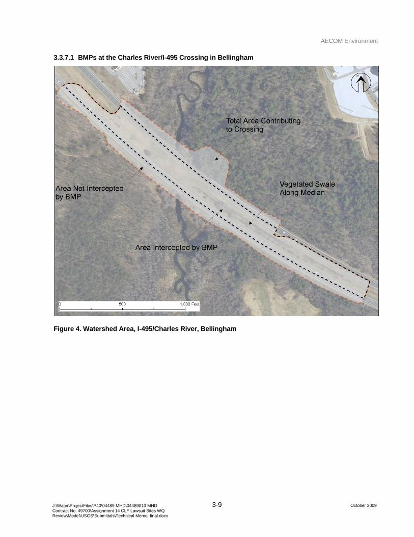
AECOM Environment
3-9 October 2009 J:\Water\ProjectFiles\P40\04489 MHD\04489013 MHD
Contract No. 49700\Assignment 14 CLF Lawsuit Sites WQ Review\Model\USGS\Submittals\Technical Memo final.docx
3.3.7.1 BMPs at the Charles River/I-495 Crossing in Bellingham
Figure 4. Watershed Area, I-495/Charles River, Bellingham
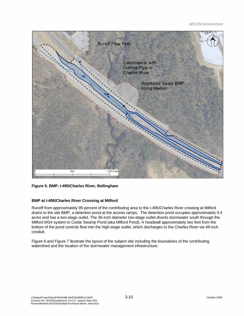
AECOM Environment
3-10 October 2009 J:\Water\ProjectFiles\P40\04489 MHD\04489013 MHD
Contract No. 49700\Assignment 14 CLF Lawsuit Sites WQ Review\Model\USGS\Submittals\Technical Memo final.docx
Figure 5. BMP, I-495/Charles River, Bellingham
BMP at I-495/Charles River Crossing at Milford
Runoff from approximately 95 percent of the contributing area to the I-495/Charles River crossing at Milford drains to the site BMP, a detention pond at the access ramps. The detention pond occupies approximately 0.4 acres and has a two-stage outlet. The 36-inch diameter low-stage outlet diverts stormwater south through the Milford MS4 system to Cedar Swamp Pond (aka Milford Pond). A headwall approximately two feet from the bottom of the pond controls flow into the high-stage outlet, which discharges to the Charles River via 48-inch conduit.
Figure 6 and Figure 7 illustrate the layout of the subject site including the boundaries of the contributing watershed and the location of the stormwater management infrastructure.
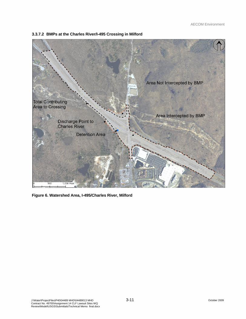
AECOM Environment
3-11 October 2009 J:\Water\ProjectFiles\P40\04489 MHD\04489013 MHD
Contract No. 49700\Assignment 14 CLF Lawsuit Sites WQ Review\Model\USGS\Submittals\Technical Memo final.docx
3.3.7.2 BMPs at the Charles River/I-495 Crossing in Milford
Figure 6. Watershed Area, I-495/Charles River, Milford
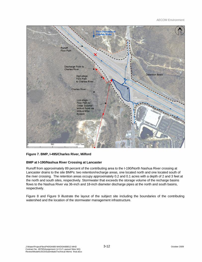
AECOM Environment
3-12 October 2009 J:\Water\ProjectFiles\P40\04489 MHD\04489013 MHD
Contract No. 49700\Assignment 14 CLF Lawsuit Sites WQ Review\Model\USGS\Submittals\Technical Memo final.docx
Figure 7. BMP, I-495/Charles River, Milford
BMP at I-190/Nashua River Crossing at Lancaster
Runoff from approximately 89 percent of the contributing area to the I-190/North Nashua River crossing at Lancaster drains to the site BMPs: two retention/recharge areas, one located north and one located south of the river crossing. The retention areas occupy approximately 0.2 and 0.1 acres with a depth of 2 and 3 feet at the north and south sites, respectively. Stormwater that exceeds the storage volume of the recharge basins flows to the Nashua River via 36-inch and 18-inch diameter discharge pipes at the north and south basins, respectively.
Figure 8 and Figure 9 illustrate the layout of the subject site including the boundaries of the contributing watershed and the location of the stormwater management infrastructure.
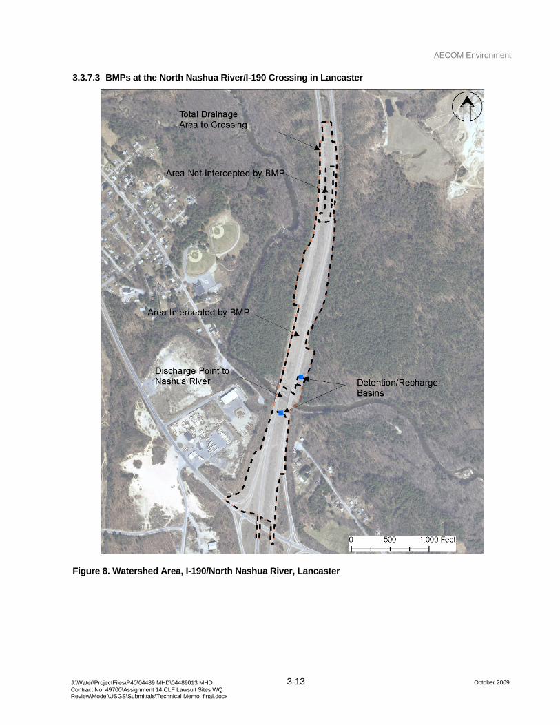
AECOM Environment
3-13 October 2009 J:\Water\ProjectFiles\P40\04489 MHD\04489013 MHD
Contract No. 49700\Assignment 14 CLF Lawsuit Sites WQ Review\Model\USGS\Submittals\Technical Memo final.docx
3.3.7.3 BMPs at the North Nashua River/I-190 Crossing in Lancaster
Figure 8. Watershed Area, I-190/North Nashua River, Lancaster
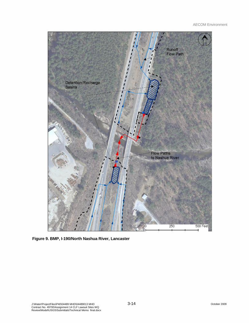
AECOM Environment
3-14 October 2009 J:\Water\ProjectFiles\P40\04489 MHD\04489013 MHD
Contract No. 49700\Assignment 14 CLF Lawsuit Sites WQ Review\Model\USGS\Submittals\Technical Memo final.docx
Figure 9. BMP, I-190/North Nashua River, Lancaster
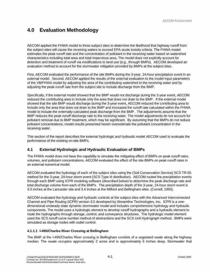
AECOM Environment
4-1 October 2009 J:\Water\ProjectFiles\P40\04489 MHD\04489013 MHD
Contract No. 49700\Assignment 14 CLF Lawsuit Sites WQ Review\Model\USGS\Submittals\Technical Memo final.docx
4.0 Evaluation Methodology
AECOM applied the FHWA model to three subject sites to determine the likelihood that highway runoff from the subject sites will cause the receiving waters to exceed EPA acute toxicity criteria. The FHWA model estimates the peak runoff rate and the concentration of pollutant in the receiving water based on watershed characteristics including total area and total impervious area. The model does not explicitly account for detention and treatment of runoff via modifications to land use (e.g., through BMPs). AECOM developed an evaluation method to account for the stormwater mitigation provided by BMPs at the subject sites.
First, AECOM evaluated the performance of the site BMPs during the 3-year, 24-hour precipitation event in an external model. Second, AECOM applied the results of the external evaluation to the model input parameters of the VB/FHWA model by adjusting the area of the contributing watershed to the receiving water and by adjusting the peak runoff rate from the subject site to include discharge from the BMP.
Specifically, if the external model showed that the BMP would not discharge during the 3-year event, AECOM reduced the contributing area to include only the area that does not drain to the BMP. If the external model showed that the site BMP would discharge during the 3-year event, AECOM reduced the contributing area to include only the area that does not drain to the BMP and increased the runoff rate calculated within the FHWA model to include the externally-calculated peak discharge from the BMP. The adjustments assume that the BMP reduces the peak runoff discharge rate to the receiving water. The model adjustments do not account for pollutant removal due to BMP treatment, which may be significant. By assuming that the BMPs do not reduce pollutant concentrations, model results presented herein overestimate the pollutant concentration in the receiving water.
This section of the report describes the external hydrologic and hydraulic model AECOM used to evaluate the performance of the existing on-site BMPs.
4.1 External Hydrologic and Hydraulic Evaluation of BMPs
The FHWA model does not have the capability to simulate the mitigating effect of BMPs on peak runoff rates, volumes, and pollutant concentrations. AECOM evaluated the effect of the site BMPs on peak runoff rates in an external numerical model.
AECOM evaluated the hydrology of each of the subject sites using the (Soil Conservation Service) SCS TR-55 method for the 3-year, 24-hour storm event (SCS Type III distribution). AECOM routed the precipitation events through each BMP using ICPR modeling software (described below) to determine the peak discharge rate and total discharge volume from each of the BMPs. The precipitation depth of the 3-year, 24-hour storm event is 3.3 inches at the Lancaster site and 3.4 inches at the Milford and Bellingham sites. (Cornell, 1993).
AECOM evaluated the hydrology and hydraulic controls at the subject sites with the Advanced Interconnected Channel and Pipe Routing (ICPR) version 3.0 developed by Streamline Technologies, Inc. ICPR is a one-dimensional unsteady-state dynamic stormwater model and includes comprehensive hydrology and hydraulic components. The model uses a hydrologic element to develop runoff hydrographs and a hydraulic element to route the hydrographs through storage, control, and conveyance structures. The hydrologic model element used the SCS runoff curve number method of abstractions and the SCS Unit Hydrograph method. BMPs were simulated as storage nodes with outlet control.
4.1.1.1 I-495/Charles River Crossing at Bellingham
The BMP at the I-495/Charles River crossing in Bellingham consists of a vegetated swale along the highway median. The swale occupies approximately 2 acres and is approximately 6 inches deep. Stormwater that
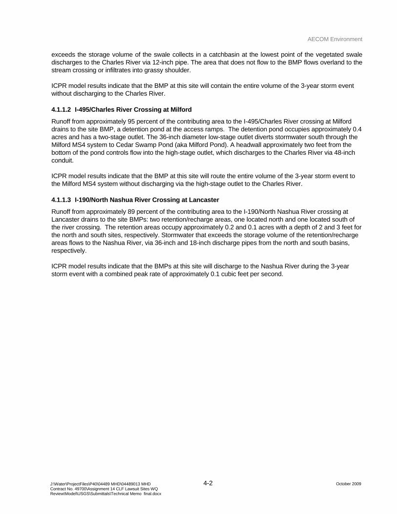
AECOM Environment
4-2 October 2009 J:\Water\ProjectFiles\P40\04489 MHD\04489013 MHD
Contract No. 49700\Assignment 14 CLF Lawsuit Sites WQ Review\Model\USGS\Submittals\Technical Memo final.docx
exceeds the storage volume of the swale collects in a catchbasin at the lowest point of the vegetated swale discharges to the Charles River via 12-inch pipe. The area that does not flow to the BMP flows overland to the stream crossing or infiltrates into grassy shoulder.
ICPR model results indicate that the BMP at this site will contain the entire volume of the 3-year storm event without discharging to the Charles River.
4.1.1.2 I-495/Charles River Crossing at Milford
Runoff from approximately 95 percent of the contributing area to the I-495/Charles River crossing at Milford drains to the site BMP, a detention pond at the access ramps. The detention pond occupies approximately 0.4 acres and has a two-stage outlet. The 36-inch diameter low-stage outlet diverts stormwater south through the Milford MS4 system to Cedar Swamp Pond (aka Milford Pond). A headwall approximately two feet from the bottom of the pond controls flow into the high-stage outlet, which discharges to the Charles River via 48-inch conduit.
ICPR model results indicate that the BMP at this site will route the entire volume of the 3-year storm event to the Milford MS4 system without discharging via the high-stage outlet to the Charles River.
4.1.1.3 I-190/North Nashua River Crossing at Lancaster
Runoff from approximately 89 percent of the contributing area to the I-190/North Nashua River crossing at Lancaster drains to the site BMPs: two retention/recharge areas, one located north and one located south of the river crossing. The retention areas occupy approximately 0.2 and 0.1 acres with a depth of 2 and 3 feet for the north and south sites, respectively. Stormwater that exceeds the storage volume of the retention/recharge areas flows to the Nashua River, via 36-inch and 18-inch discharge pipes from the north and south basins, respectively.
ICPR model results indicate that the BMPs at this site will discharge to the Nashua River during the 3-year storm event with a combined peak rate of approximately 0.1 cubic feet per second.
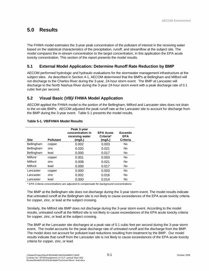
AECOM Environment
5-1 October 2009 J:\Water\ProjectFiles\P40\04489 MHD\04489013 MHD
Contract No. 49700\Assignment 14 CLF Lawsuit Sites WQ Review\Model\USGS\Submittals\Technical Memo final.docx
5.0 Results
The FHWA model estimates the 3-year peak concentration of the pollutant of interest in the receiving water based on the statistical characteristics of the precipitation, runoff, and streamflow at the subject site. The model compares the in-stream concentration to the target concentration, in this application the EPA acute toxicity concentration. This section of the report presents the model results.
5.1 External Model Application: Determine Runoff Rate Reduction by BMP
AECOM performed hydrologic and hydraulic evaluations for the stormwater management infrastructure at the subject sites. As described in Section 4-1, AECOM determined that the BMPs at Bellingham and Milford will not discharge to the Charles River during the 3-year, 24-hour storm event. The BMP at Lancaster will discharge to the North Nashua River during the 3-year 24-hour storm event with a peak discharge rate of 0.1 cubic feet per second.
5.2 Visual Basic (VB)/ FHWA Model Application
AECOM applied the FHWA model to the portion of the Bellingham, Milford and Lancaster sites does not drain to the on-site BMPs. AECOM adjusted the peak runoff rate at the Lancaster site to account for discharge from the BMP during the 3-year event. Table 5-1 presents the model results.
Table 5-1. VB/FHWA Model Results
Site Pollutant
Peak 3-year concentration in receiving water
(mg/L)
EPA Acute Criteria* (mg/L)
Exceeds EPA
Criteria Bellingham copper 0.002 0.003 No Bellingham zinc 0.020 0.021 No Bellingham lead 0.000 0.017 No Milford copper 0.001 0.003 No Milford zinc 0.008 0.021 No Milford lead 0.000 0.017 No Lancaster copper 0.000 0.003 No Lancaster zinc 0.002 0.016 No Lancaster lead 0.000 0.014 No * EPA Criteria concentrations are adjusted to compensate for background concentrations
The BMP at the Bellingham site does not discharge during the 3-year storm event. The model results indicate that untreated runoff at the Bellingham site is not likely to cause exceedances of the EPA acute toxicity criteria for copper, zinc, or lead at the subject crossing.
Similarly, the Milford site BMP does not discharge during the 3-year storm event. According to the model results, untreated runoff at the Milford site is not likely to cause exceedances of the EPA acute toxicity criteria for copper, zinc, or lead at the subject crossing.
The BMP at the Lancaster site discharges at a peak rate of 0.1 cubic feet per second during the 3-year storm event. The model accounts for the peak discharge rate of untreated runoff and the discharge from the BMP. The model does not account for pollutant load reductions resulting from treatment by the BMP. Our model results indicate that runoff from the Lancaster site is not likely to cause exceedances of the EPA acute toxicity criteria for copper, zinc, or lead.
AECOM Environment
6-1 October 2009 J:\Water\ProjectFiles\P40\04489 MHD\04489013 MHD
Contract No. 49700\Assignment 14 CLF Lawsuit Sites WQ Review\Model\USGS\Submittals\Technical Memo final.docx
6.0 Conclusions
According to the FHWA model methodology and results, existing BMPs at the subject sites are adequate to maintain compliance with MassHighway’s General Stormwater Permit at these sites and therefore, AECOM suggests that MassHighway should not construct additional BMPs at these stream crossings. The model indicates that MassHighway runoff is not likely to cause exceedances of the EPA acute toxicity criteria in the receiving waters at the subject sites. Each of the subject sites has a BMP, or multiple BMPs, that adequately collect and detain(s) MassHighway runoff.
The Bellingham vegetated swale does not discharge to the Charles River during the 3-year, 24-hour precipitation event. The model results indicate that highway runoff that does not drain to the BMP is not likely to cause exceedance of the EPA acute toxicity criteria for copper, zinc, or lead; therefore AECOM concludes that highway runoff from the Bellingham site is not likely to cause the Charles River to exceed EPA acute toxicity criteria for copper, zinc, or lead at this crossing.
Stormwater does not discharge from the Milford detention pond to the Charles River at the subject crossing during the 3-year, 24-hour precipitation event. The model results indicate that highway runoff that does not drain to the BMP is not likely to cause exceedance of the EPA acute toxicity concentration criteria for copper, zinc, or lead. Consequently, AECOM concludes that highway runoff from the Milford site is not likely to cause the Charles River to exceed EPA acute toxicity criteria for copper, zinc, or lead.
The Lancaster retention/recharge basins discharge a minimal amount to the North Nashua River during the 3-year, 24-hour precipitation event. The model results indicate highway runoff that does not drain to the BMP is not likely to cause exceedance of the EPA acute toxicity concentration criteria for copper, zinc, or lead. AECOM concludes that highway runoff from the Lancaster site is not likely to cause the North Nashua River to exceed EPA acute toxicity criteria for copper, zinc, or lead.
AECOM Environment
7-1 October 2009 J:\Water\ProjectFiles\P40\04489 MHD\04489013 MHD
Contract No. 49700\Assignment 14 CLF Lawsuit Sites WQ Review\Model\USGS\Submittals\Technical Memo final.docx
7.0 References
Cornell, 1993. Daniel Wilks and Richard P. Sember. Northeast Regional Climate Center, Atlas of Precipitation Extremes for the Northeastern United States and Southeastern Canada. Cornell University, Ithaca, NY, Publication No. RR 93-95. September 1993.
National Oceanic and Atmospheric Administration, National Climatic Data Center (NCDC). Hourly Precipitation. Earth Info Version 2.4.
SELDM. MassHighway runoff concentrations in the USGS/DOT/FHWA database, “Highway Runoff Database: A Data Warehouse and Preprocessor for the Stochastic Empirical Loading and Dilution Model (SELDM), version 1.0.0a.” September 2009.
USDOT FHWA, 1990a. Pollutant Loadings and Impacts from Highway Stormwater Runoff Volume I: Design Procedure, Publication No. FHWA-RD-88-006, April 1990.
USDOT FHWA, 1990b. Pollutant Loadings and Impacts from Highway Stormwater Runoff Volume 2: Users Guide for Interactive Computer Implementation of Design Procedure”, Publication No. FHWA-RD-88-007, April 1990.
USDOT FHWA, 1990c. Pollutant Loadings and Impacts from Highway Stormwater Runoff Volume 3: Analytical Investigation and Research Report”, Publication No. FHWA-RD-88-007, April 1990.
USGS, 2000. A Synopsis of Technical Issues of Concern for Monitoring Trace Elements in Highway and Urban Runoff. Robert F. Breault and Gregory Granato, OFR 00-422. Northborough, Massachusetts, 2000.
Novotny, 2007. “Pollution and Receiving Water Quality Impairment by Massachusetts Highway Systems,” Case # 06-11295WGY. Vladmir Novotny, Newton, Massachusetts, October 3, 2007.
USGS, April 2009. Draft Concentration of Suspended Sediment, Major Ions, Nutrients, Trace Elements, and Semivolatile Compounds in Stormwater Discharged from Massachusetts Highways. Kirk P. Smith. Unpublished.
USGS. Surface Water Daily Discharge Data. Station 01103280 Charles River at Medway, MA. http://waterdata.usgs.gov/nwis/sw November 1997 - Present day. June 2009.
USGS. Surface Water Daily Discharge Data. Station 01094500 North Nashua River near Leominster, MA. http://waterdata.usgs.gov/nwis/sw September 1930 - Present day. June 2009.

AECOM Environment
A-1 October 2009 J:\Water\ProjectFiles\P40\04489 MHD\04489013 MHD
Contract No. 49700\Assignment 14 CLF Lawsuit Sites WQ Review\Model\USGS\Submittals\Technical Memo final.docx
Appendix A VB/FHWA Model
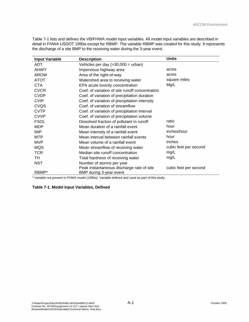
AECOM Environment
A-1 October 2009 J:\Water\ProjectFiles\P40\04489 MHD\04489013 MHD
Contract No. 49700\Assignment 14 CLF Lawsuit Sites WQ Review\Model\USGS\Submittals\Technical Memo final.docx
Table 7-1 lists and defines the VB/FHWA model input variables. All model input variables are described in detail in FHWA USDOT 1990a except for RBMP. The variable RBMP was created for this study. It represents the discharge of a site BMP to the receiving water during the 3-year event.
Input Variable Description Units
ADT Vehicles per day (>30,000 = urban) AHWY Impervious highway area acres AROW Area of the right-of-way acres ATOT Watershed area to receiving water square miles CTA EPA acute toxicity concentration Mg/L CVCR Coef. of variation of site runoff concentration CVDP Coef. of variation of precipitation duration CVIP Coef. of variation of precipitation intensity CVQS Coef. of variation of streamflow CVTP Coef. of variation of precipitation interval CVVP Coef. of variation of precipitation volume FSOL Dissolved fraction of pollutant in runoff ratio MDP Mean duration of a rainfall event hour MIP Mean intensity of a rainfall event inches/hour MTP Mean interval between rainfall events hour MVP Mean volume of a rainfall event inches MQS Mean streamflow of receiving water cubic feet per second TCR Median site runoff concentration mg/L TH Total hardness of receiving water mg/L NST Number of storms per year
RBMP* Peak instantaneous discharge rate of site BMP during 3-year event
cubic feet per second
* Variable not present in FHWA model (1990a). Variable defined and used as part of this study.
Table 7-1. Model Input Variables, Defined
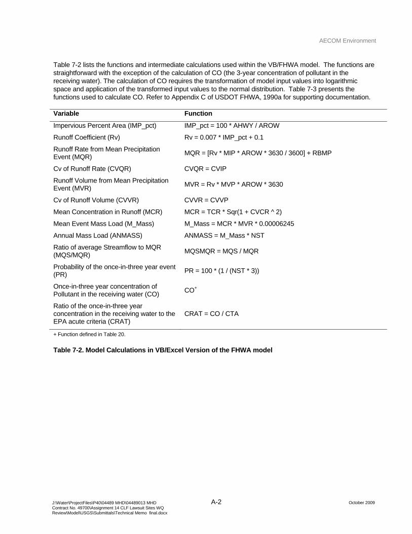
AECOM Environment
A-2 October 2009 J:\Water\ProjectFiles\P40\04489 MHD\04489013 MHD
Contract No. 49700\Assignment 14 CLF Lawsuit Sites WQ Review\Model\USGS\Submittals\Technical Memo final.docx
Table 7-2 lists the functions and intermediate calculations used within the VB/FHWA model. The functions are straightforward with the exception of the calculation of CO (the 3-year concentration of pollutant in the receiving water). The calculation of CO requires the transformation of model input values into logarithmic space and application of the transformed input values to the normal distribution. Table 7-3 presents the functions used to calculate CO. Refer to Appendix C of USDOT FHWA, 1990a for supporting documentation.
Variable Function
Impervious Percent Area (IMP_pct) IMP_pct = 100 * AHWY / AROW
Runoff Coefficient (Rv) Rv = 0.007 * IMP_pct + 0.1
Runoff Rate from Mean Precipitation Event (MQR) MQR = [Rv * MIP * AROW * 3630 / 3600] + RBMP
Cv of Runoff Rate (CVQR) CVQR = CVIP
Runoff Volume from Mean Precipitation Event (MVR) MVR = Rv * MVP * AROW * 3630
Cv of Runoff Volume (CVVR) CVVR = CVVP
Mean Concentration in Runoff (MCR) MCR = TCR * Sqr(1 + CVCR ^ 2)
Mean Event Mass Load (M_Mass) M_Mass = MCR * MVR * 0.00006245
Annual Mass Load (ANMASS) ANMASS = M_Mass * NST
Ratio of average Streamflow to MQR (MQS/MQR) MQSMQR = MQS / MQR
Probability of the once-in-three year event (PR) PR = 100 * (1 / (NST * 3))
Once-in-three year concentration of Pollutant in the receiving water (CO) CO+
Ratio of the once-in-three year concentration in the receiving water to the EPA acute criteria (CRAT)
CRAT = CO / CTA
+ Function defined in Table 20.
Table 7-2. Model Calculations in VB/Excel Version of the FHWA model
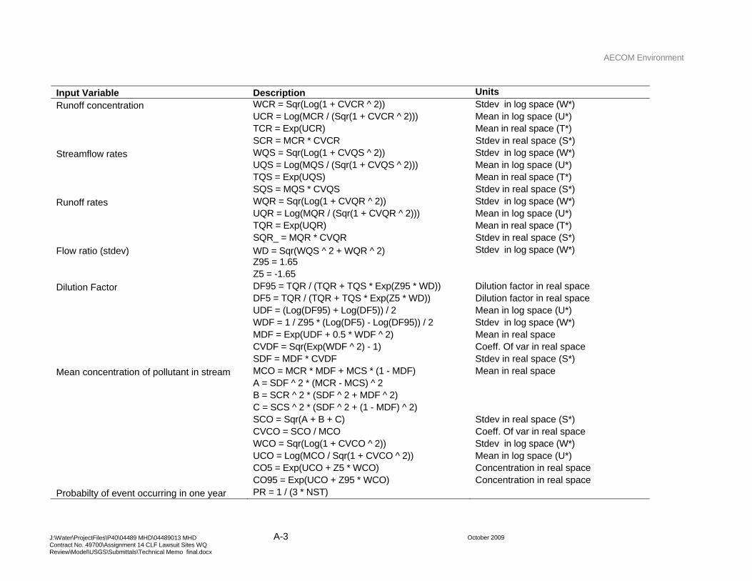
AECOM Environment
A-3 October 2009 J:\Water\ProjectFiles\P40\04489 MHD\04489013 MHD
Contract No. 49700\Assignment 14 CLF Lawsuit Sites WQ Review\Model\USGS\Submittals\Technical Memo final.docx
Input Variable Description Units
Runoff concentration WCR = Sqr(Log(1 + CVCR ^ 2)) Stdev in log space (W*) UCR = Log(MCR / (Sqr(1 + CVCR ^ 2))) Mean in log space (U*) TCR = Exp(UCR) Mean in real space (T*) SCR = MCR * CVCR Stdev in real space (S*) Streamflow rates WQS = Sqr(Log(1 + CVQS ^ 2)) Stdev in log space (W*) UQS = Log(MQS / (Sqr(1 + CVQS ^ 2))) Mean in log space (U*) TQS = Exp(UQS) Mean in real space (T*) SQS = MQS * CVQS Stdev in real space (S*) Runoff rates WQR = Sqr(Log(1 + CVQR ^ 2)) Stdev in log space (W*) UQR = Log(MQR / (Sqr(1 + CVQR ^ 2))) Mean in log space (U*) TQR = Exp(UQR) Mean in real space (T*) SQR_ = MQR * CVQR Stdev in real space (S*) Flow ratio (stdev) WD = Sqr(WQS ^ 2 + WQR ^ 2) Stdev in log space (W*) Z95 = 1.65 Z5 = -1.65 Dilution Factor DF95 = TQR / (TQR + TQS * Exp(Z95 * WD)) Dilution factor in real space DF5 = TQR / (TQR + TQS * Exp(Z5 * WD)) Dilution factor in real space UDF = (Log(DF95) + Log(DF5)) / 2 Mean in log space (U*) WDF = 1 / Z95 * (Log(DF5) - Log(DF95)) / 2 Stdev in log space (W*) MDF = Exp(UDF + 0.5 * WDF ^ 2) Mean in real space CVDF = Sqr(Exp(WDF ^ 2) - 1) Coeff. Of var in real space SDF = MDF * CVDF Stdev in real space (S*) Mean concentration of pollutant in stream MCO = MCR * MDF + MCS * (1 - MDF) Mean in real space A = SDF ^ 2 * (MCR - MCS) ^ 2 B = SCR ^ 2 * (SDF ^ 2 + MDF ^ 2) C = SCS ^ 2 * (SDF ^ 2 + (1 - MDF) ^ 2) SCO = Sqr(A + B + C) Stdev in real space (S*) CVCO = SCO / MCO Coeff. Of var in real space WCO = Sqr(Log(1 + CVCO ^ 2)) Stdev in log space (W*) UCO = Log(MCO / Sqr(1 + CVCO ^ 2)) Mean in log space (U*) CO5 = Exp(UCO + Z5 * WCO) Concentration in real space CO95 = Exp(UCO + Z95 * WCO) Concentration in real space Probabilty of event occurring in one year PR = 1 / (3 * NST)
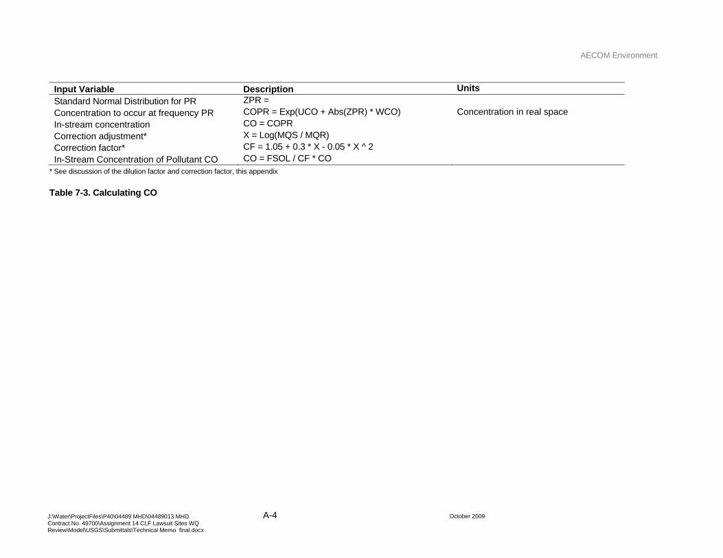
AECOM Environment
A-4 October 2009 J:\Water\ProjectFiles\P40\04489 MHD\04489013 MHD
Contract No. 49700\Assignment 14 CLF Lawsuit Sites WQ Review\Model\USGS\Submittals\Technical Memo final.docx
Input Variable Description Units
Standard Normal Distribution for PR ZPR = Concentration to occur at frequency PR COPR = Exp(UCO + Abs(ZPR) * WCO) Concentration in real space In-stream concentration CO = COPR Correction adjustment* X = Log(MQS / MQR) Correction factor* CF = 1.05 + 0.3 * X - 0.05 * X ^ 2 In-Stream Concentration of Pollutant CO CO = FSOL / CF * CO
* See discussion of the dilution factor and correction factor, this appendix
Table 7-3. Calculating CO
AECOM Environment
A-5 October 2009 J:\Water\ProjectFiles\P40\04489 MHD\04489013 MHD
Contract No. 49700\Assignment 14 CLF Lawsuit Sites WQ Review\Model\USGS\Submittals\Technical Memo final.docx
Discussion of the Dilution Factor and the subsequent correction factor
USDOT FHWA 1990a Appendix B (page 50) describes the validity of some assumptions used to estimate the concentration of pollutant in the receiving water. In particular, the documentation indicates that for systems where the dilution factor (the ratio of runoff to streamflow) is near one or near zero, calculations of CO have significant error because the assumption that the dilution factor is lognormal no longer holds. The documentation describes a correction factor that is a function of the ratio of stream flow to runoff. The correction factor was developed by comparing estimates of CO using the simplified method described in the FHWA model documentation and using a complex numerical method in the associated numerical software model. Refer to page 49 and 50 of USDOT FHWA 1990a Appendix B for more information.
Application of the correction factor to model results reported in this study resulted in surprising outcomes. Some model results indicated that the presence of a BMP on a study site would result in increases in the in-stream concentration of the receiving water despite the decrease in runoff volume and peak rate from the subject site. Sites experiencing this problem consistently had large dilution ratios (high streamflow, low runoff). At these sites, the correction factor returned a value of less than one and application of the correction value to the estimated in-stream concentrations increased the estimate of the in-stream concentration.
In a situation where a smaller contributing area and a smaller percent impervious area resulted in a higher in-stream concentration in the receiving water, the correction factor was eliminated. The model documentation indicates that eliminating the correction factor introduces error that is almost always conservative, “that is, it projects high concentrations to occur more frequently than they actually would be expected to”.
In addition, the analysis to develop the correction factor function indicates that the FHWA USDOT evaluated sites where the streamflow to runoff ratio ranged from 0.5 to 100. Several sites evaluated in this study had streamflow to runoff ratios over 100. It is not clear if the correction factor regression equation can be extrapolated beyond the range presented in the documentation. For models where the ratio of streamflow to runoff exceeded 200, the correction factor was eliminated.

AECOM Environment
October 2009 J:\Water\ProjectFiles\P40\04489 MHD\04489013 MHD
Contract No. 49700\Assignment 14 CLF Lawsuit Sites WQ Review\Model\USGS\Submittals\Technical Memo final.docx
Appendix B Model Input and Output Reports
AECOM Environment
C-7 October 2009 J:\Water\ProjectFiles\P40\04489 MHD\04489013 MHD
Contract No. 49700\Assignment 14 CLF Lawsuit Sites WQ Review\Model\USGS\Submittals\Technical Memo final.docx
Milford with BMPs Variable copper zinc lead AHWY 0.05 0.05 0.05 AROW 2.4 2.4 2.4 CTA 0.00331 0.0209 0.017175 CTT 0.01775 0.369666667 0.14375 CVCR 0.93 0.99 1.23 CVDP 1.03 1.03 1.03 CVIP 1.02 1.02 1.02 CVQS 0.99 0.99 0.99 CVVP 1.67 1.67 1.67 FSOL 0.52 0.65 0.12 MDP 6.1 6.1 6.1 MIP 0.044 0.044 0.044 MVP 0.33 0.33 0.33 MQS 9.6 9.6 9.6 TCR 0.0263 0.173 0.0082 TH 37.5 37.5 37.5 NST 128 128 128 RBMP 0 0 0
Table 7-4. Input Report, I-495/Charles River Crossing, Milford
AECOM Environment
C-8 October 2009 J:\Water\ProjectFiles\P40\04489 MHD\04489013 MHD
Contract No. 49700\Assignment 14 CLF Lawsuit Sites WQ Review\Model\USGS\Submittals\Technical Memo final.docx
Bellingham with BMPs Variable copper zinc lead AHWY 3.2 3.2 3.2 AROW 9.2 9.2 9.2 CTA 0.00331 0.0209 0.017175 CTT 0.01775 0.369666667 0.14375 CVCR 0.93 0.99 1.23 CVDP 1.03 1.03 1.03 CVIP 1.02 1.02 1.02 CVQS 1.18 1.18 1.18 CVVP 1.67 1.67 1.67 FSOL 0.52 0.65 0.12 MDP 6.1 6.1 6.1 MIP 0.044 0.044 0.044 MVP 0.33 0.33 0.33 MQS 54.8 54.8 54.8 TCR 0.0263 0.173 0.0082 TH 37.5 37.5 37.5 NST 128 128 128 RBMP 0 0 0
Table 7-5. Input Report, I-495/Charles River Crossing, Bellingham
AECOM Environment
C-9 October 2009 J:\Water\ProjectFiles\P40\04489 MHD\04489013 MHD
Contract No. 49700\Assignment 14 CLF Lawsuit Sites WQ Review\Model\USGS\Submittals\Technical Memo final.docx
Lancaster with BMPs Variable copper zinc lead AHWY 0.86 0.86 0.86 AROW 4.2 4.2 4.2 CTA 0.0027 0.0157 0.01375 CTT 0.01775 0.369666667 0.14375 CVCR 0.93 0.99 1.23 CVDP 1.03 1.03 1.03 CVIP 1.02 1.02 1.02 CVQS 1.27 1.27 1.27 CVVP 1.67 1.67 1.67 FSOL 0.52 0.65 0.12 MDP 6.1 6.1 6.1 MIP 0.044 0.044 0.044 MVP 0.33 0.33 0.33 MQS 208 208 208 TCR 0.0263 0.173 0.0082 TH 33.14 33.14 33.14 NST 128 128 128 RBMP 0.1 0.1 0.1
Table 7-6. Input Report, I-190/North Nashua River Crossing, Lancaster
AECOM Environment
C-10 October 2009 J:\Water\ProjectFiles\P40\04489 MHD\04489013 MHD
Contract No. 49700\Assignment 14 CLF Lawsuit Sites WQ Review\Model\USGS\Submittals\Technical Memo final.docx
Milford with BMPs Variable copper zinc lead CTA 0.003 0.021 0.017 CTT 0.018 0.370 0.144 CO 0.001 0.008 0.000 CRAT 0.271 0.375 0.005 CRTE 0.051 0.021 0.001
Table 7-7. Output Report, I-495/Charles River Crossing, Milford
Bellingham with BMPs Variable copper zinc lead CTA 0.003 0.021 0.017 CTT 0.018 0.370 0.144 CO 0.002 0.020 0.000 CRAT 0.709 0.976 0.013 CRTE 0.132 0.055 0.002
Table 7-8. Output Report, I-495/Charles River Crossing, Bellingham
Lancaster with BMPs Variable copper zinc lead CTA 0.003 0.016 0.014 CTT 0.018 0.370 0.144 CO 0.000 0.002 0.000 CRAT 0.086 0.128 0.002 CRTE 0.013 0.005 0.000
Table 7-9. Output Report, I-190/North Nashua River Crossing, Lancaster
NPDES Storm Water Management Plan Annual Report – Permit Year 7
4/26/2010 J-1
Appendix J: Bay State Roads Newsletter
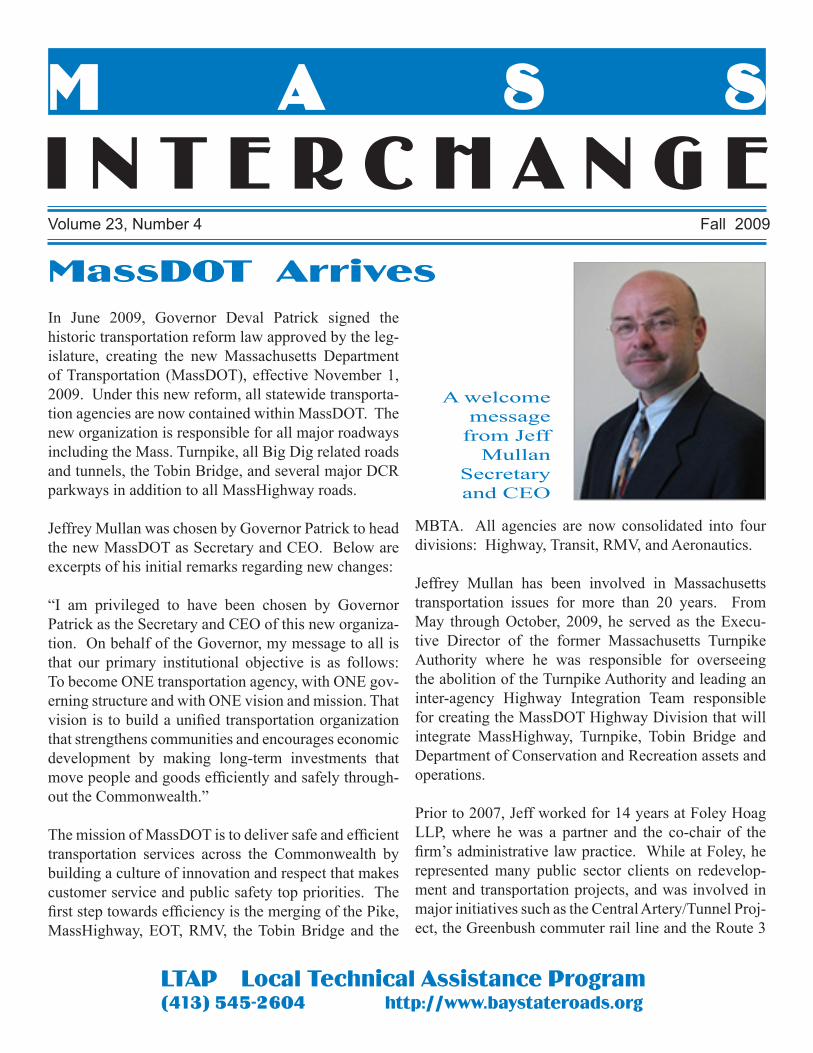
I N T E R C H A N G EVolume 23, Number 4 Fall 2009
M A S S
LTAP Local Technical Assistance Program(413) 545-2604 http://www.baystateroads.org
In June 2009, Governor Deval Patrick signed the historic transportation reform law approved by the leg-islature, creating the new Massachusetts Department of Transportation (MassDOT), effective November 1, 2009. Under this new reform, all statewide transporta-tion agencies are now contained within MassDOT. The new organization is responsible for all major roadways including the Mass. Turnpike, all Big Dig related roads and tunnels, the Tobin Bridge, and several major DCR parkways in addition to all MassHighway roads.
Jeffrey Mullan was chosen by Governor Patrick to head the new MassDOT as Secretary and CEO. Below are excerpts of his initial remarks regarding new changes:
“I am privileged to have been chosen by Governor Patrick as the Secretary and CEO of this new organiza-tion. On behalf of the Governor, my message to all is that our primary institutional objective is as follows: To become ONE transportation agency, with ONE gov-erning structure and with ONE vision and mission. That vision is to build a unified transportation organization that strengthens communities and encourages economic development by making long-term investments that move people and goods efficiently and safely through-out the Commonwealth.”
The mission of MassDOT is to deliver safe and efficient transportation services across the Commonwealth by building a culture of innovation and respect that makes customer service and public safety top priorities. The first step towards efficiency is the merging of the Pike, MassHighway, EOT, RMV, the Tobin Bridge and the
MBTA. All agencies are now consolidated into four divisions: Highway, Transit, RMV, and Aeronautics.
Jeffrey Mullan has been involved in Massachusetts transportation issues for more than 20 years. From May through October, 2009, he served as the Execu-tive Director of the former Massachusetts Turnpike Authority where he was responsible for overseeing the abolition of the Turnpike Authority and leading an inter-agency Highway Integration Team responsible for creating the MassDOT Highway Division that will integrate MassHighway, Turnpike, Tobin Bridge and Department of Conservation and Recreation assets and operations.
Prior to 2007, Jeff worked for 14 years at Foley Hoag LLP, where he was a partner and the co-chair of the firm’s administrative law practice. While at Foley, he represented many public sector clients on redevelop-ment and transportation projects, and was involved in major initiatives such as the Central Artery/Tunnel Proj-ect, the Greenbush commuter rail line and the Route 3
MassDOT Arrives
A welcome message
from Jeff Mullan
Secretaryand CEO
North project. He also represented the Commonwealth in the creation of the Rose Kennedy Greenway Con-servancy in 2004. Before joining Foley Hoag, Mul-lan worked at the former Massachusetts Department of Public Works as Right of Way Manager on the Central Artery Tunnel Project.
The goals of MassDOT, as outlined by Mullan are as follows:
First, to restore public trust by creating an open, re-sponsive and well-managed organization;
Second, to encourage a culture of innovation and ac-countability; and
Third, to leverage projects that spark economic de-velopment and support livable communities, while balancing the needs of all transportation users.
With the new MassDOT, we are unveiling a transporta-tion organization that:
Provides quality customer service to all transportation users;
Is transparent and accountable to taxpayers;
Aggressively seeks out every cost saving and efficiency possible; and
Makes critical investments in infrastructure that spark economic growth and strengthen our communities.
It’s a back-to-basics approach that anyone who cares about transportation should welcome. For munici-pal highway managers, the new legislation ends past bureaucracies and the resulting confusion as to which jurisdiction certain roadways fall under.
ITS
MassDOT Planning has recently begun updates of the Regional Intelligent Transportation Systems (ITS) Architectures for the Commonwealth of Mas-sachusetts. These architectures provide a regional framework for ITS coordination -- identifying re-gional ITS stakeholders, describing existing and planned ITS elements and specifying high-level information flows among these elements. These updates are taking place in conjunction with the overall statewide ITS Strategic Plan.
The ITS Strategic Plan will support, enable and enhance a seamless multi-modal transportation system; ensure the competitive position of the Commonwealth in regional, national and interna-tional markets; and enhance social, environmental and quality of life factors for the Commonwealth’s residents and visitors. The ITS Strategic Plan will engage the full range of the Commonwealth’s transportation stakeholders, and build consensus for the Statewide ITS Program. MassDOT will be conducting meetings across the state in four differ-ent regions to facilitate the gathering of information and the exchange of ideas. Input from all munici-pal planning and transportation agencies is strongly encouraged.
If you would like to be involved and to find out more information, please contact MassDOT’sSteve Pepin at 617-973-8051 or email him at:[email protected].
MASS INTERCHANGE Fall 20092
Installation of electronic toll collection equipment by UMass research assistants for measurement of travel time along
Route 116 in Amherst
www.massdot.state.ma.us
NEW MASTER SCHOLARGreg RounsevilleDennis DPW
an over-ride, he procured 1.2 million dollars of capital equipment. Current projects include installation of a photovoltaic array on the police station for the Alter-native Energy Committee and investigation of possible wind turbine sites.
Greg strongly believes that employees are a town’s greatest asset and that continuous investment in appropriate training, tools and equipment make an organization successful. By making these investments, a community can be better served by creating a pro-fessional, efficient and reliable workforce. He also believes that the role of a DPW should be to continually strive for greater service output, improved efficiency, transparency and quality of work.
In keeping with his belief in education, Greg graduated with a Bachelor of Science Degree in Business Admin-istration from Suffolk University with honors (Beta Gamma Sigma) in 2008 and is currently enrolled in the MPA program. He lives in Dennisport with his wife, Carrie; daughter, Kate; and dog, Maisy. His favorite pastimes are spending time with his family at the beach, biking, boating and working in the yard.
Greg Rounseville has worked in the construction field for over 20 years. While working as a framing fore-man, he obtained an Associate Degree in Construction Technology and Management (with honors in 1991) at Cape Cod Community College. Further employ-ment included surveying and construction supervision. He is also certified as a Massachusetts Title 5 System Inspector.
After spending time in the private sector, Greg joined the engineering division at the Town of Dennis DPW in 1998. He was responsible for day-to-day field opera-tions including drainage installation, culvert replace-ment, pavement projects and building construction. He conducted quantity take off, cost estimating, and pur-chasing while scheduling and coordinating progress of all facets of work. In 2004 he was promoted to assistant superintendent where he assists with management and supervision of more than 30 employees, and the prepa-ration, presentation, and execution of an annual budget of 3.5 million dollars. He is responsible for supervision of the cemetery, fleet maintenance, grounds, highway and sanitation personnel. After obtaining funds from
Chris Ahmadjian presented a Master Roads Scholar plaque along with a jacket to Greg Rounseville at the Baystate Roads Advisory Board Meeting in October 2009
MASS INTERCHANGEFall 2009 3
HAVE YOU QUALIFIED FOR ROADS SCHOLAR OR MASTER ROAD SCHOLAR AWARDS?Our workshop database will confirm your attendance at 7 classes for the first level or 22 classes for the Master level. Please provide T-Shirt size, your address and your supervisor’s name, title, and address when notifying Bay-state Roads Program of your status at: [email protected]
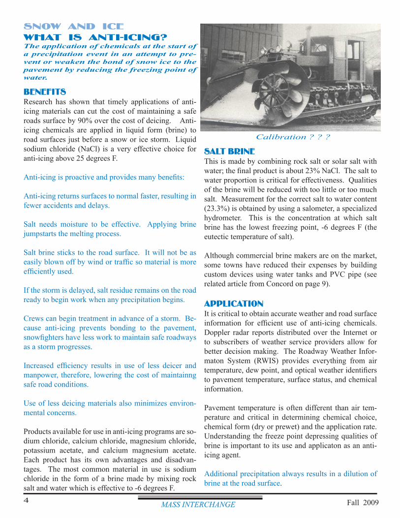
BENEFITSResearch has shown that timely applications of anti-icing materials can cut the cost of maintaining a safe roads surface by 90% over the cost of deicing. Anti-icing chemicals are applied in liquid form (brine) to road surfaces just before a snow or ice storm. Liquid sodium chloride (NaCl) is a very effective choice for anti-icing above 25 degrees F.
Anti-icing is proactive and provides many benefits:
Anti-icing returns surfaces to normal faster, resulting in fewer accidents and delays.
Salt needs moisture to be effective. Applying brine jumpstarts the melting process.
Salt brine sticks to the road surface. It will not be as easily blown off by wind or traffic so material is more efficiently used.
If the storm is delayed, salt residue remains on the road ready to begin work when any precipitation begins.
Crews can begin treatment in advance of a storm. Be-cause anti-icing prevents bonding to the pavement, snowfighters have less work to maintain safe roadways as a storm progresses.
Increased efficiency results in use of less deicer and manpower, therefore, lowering the cost of maintainng safe road conditions.
Use of less deicing materials also minimizes environ-mental concerns.
Products available for use in anti-icing programs are so-dium chloride, calcium chloride, magnesium chloride, potassium acetate, and calcium magnesium acetate. Each product has its own advantages and disadvan-tages. The most common material in use is sodium chloride in the form of a brine made by mixing rock salt and water which is effective to -6 degrees F.
SALT BRINEThis is made by combining rock salt or solar salt with water; the final product is about 23% NaCl. The salt to water proportion is critical for effectiveness. Qualities of the brine will be reduced with too little or too much salt. Measurement for the correct salt to water content (23.3%) is obtained by using a salometer, a specialized hydrometer. This is the concentration at which salt brine has the lowest freezing point, -6 degrees F (the eutectic temperature of salt).
Although commercial brine makers are on the market, some towns have reduced their expenses by building custom devices using water tanks and PVC pipe (see related article from Concord on page 9).
APPLICATIONIt is critical to obtain accurate weather and road surface information for efficient use of anti-icing chemicals. Doppler radar reports distributed over the Internet or to subscribers of weather service providers allow for better decision making. The Roadway Weather Infor-maton System (RWIS) provides everything from air temperature, dew point, and optical weather identifiers to pavement temperature, surface status, and chemical information.
Pavement temperature is often different than air tem-perature and critical in determining chemical choice, chemical form (dry or prewet) and the application rate. Understanding the freeze point depressing qualities of brine is important to its use and applicaton as an anti-icing agent.
Additional precipitation always results in a dilution of brine at the road surface.
SNOW AND ICEWHAT IS ANTI-ICING?The application of chemicals at the start of a precipitation event in an attempt to pre-vent or weaken the bond of snow ice to the pavement by reducing the freezing point of water.
Calibration ? ? ?
MASS INTERCHANGE Fall 20094
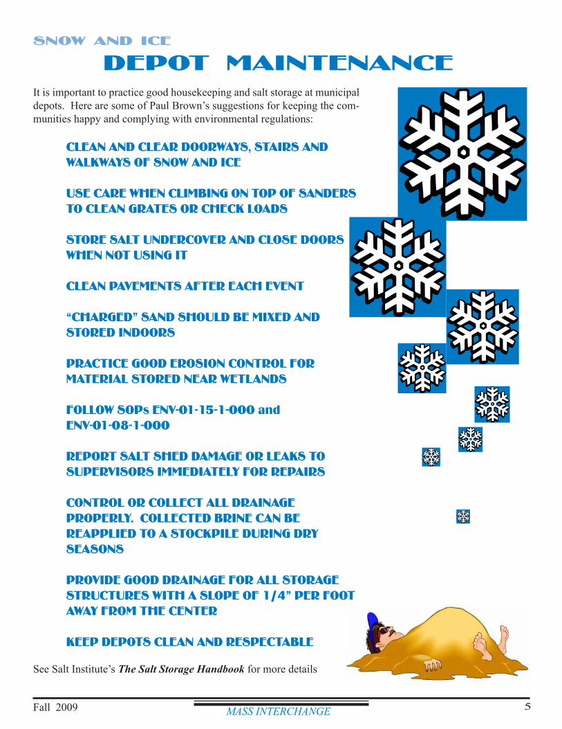
MASS INTERCHANGEFall 2009 5
DEPOT MAINTENANCEIt is important to practice good housekeeping and salt storage at municipal depots. Here are some of Paul Brown’s suggestions for keeping the com-munities happy and complying with environmental regulations:
CLEAN AND CLEAR DOORWAYS, STAIRS AND WALKWAYS OF SNOW AND ICE
USE CARE WHEN CLIMBING ON TOP OF SANDERS TO CLEAN GRATES OR CHECK LOADS
STORE SALT UNDERCOVER AND CLOSE DOORS WHEN NOT USING IT
CLEAN PAVEMENTS AFTER EACH EVENT
“CHARGED” SAND SHOULD BE MIXED AND STORED INDOORS
PRACTICE GOOD EROSION CONTROL FOR MATERIAL STORED NEAR WETLANDS
FOLLOW SOPs ENV-01-15-1-000 and ENV-01-08-1-000
REPORT SALT SHED DAMAGE OR LEAKS TO SUPERVISORS IMMEDIATELY FOR REPAIRS
CONTROL OR COLLECT ALL DRAINAGE PROPERLY. COLLECTED BRINE CAN BE REAPPLIED TO A STOCKPILE DURING DRY SEASONS
PROVIDE GOOD DRAINAGE FOR ALL STORAGE STRUCTURES WITH A SLOPE OF 1/4” PER FOOT AWAY FROM THE CENTER
KEEP DEPOTS CLEAN AND RESPECTABLE
See Salt Institute’s The Salt Storage Handbook for more details
SNOW AND ICE
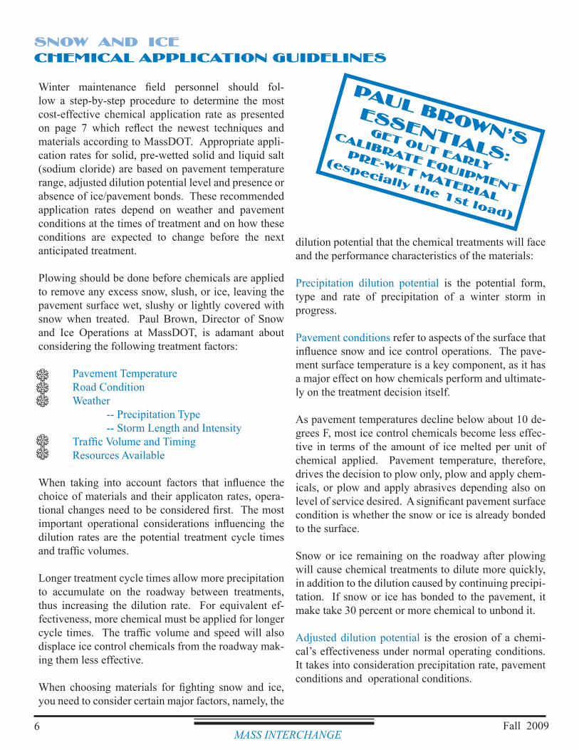
MASS INTERCHANGE6 Fall 2009
SNOW AND ICECHEMICAL APPLICATION GUIDELINES
Winter maintenance field personnel should fol-low a step-by-step procedure to determine the most cost-effective chemical application rate as presented on page 7 which reflect the newest techniques and materials according to MassDOT. Appropriate appli-cation rates for solid, pre-wetted solid and liquid salt (sodium cloride) are based on pavement temperature range, adjusted dilution potential level and presence or absence of ice/pavement bonds. These recommended application rates depend on weather and pavement conditions at the times of treatment and on how these conditions are expected to change before the next anticipated treatment.
Plowing should be done before chemicals are applied to remove any excess snow, slush, or ice, leaving the pavement surface wet, slushy or lightly covered with snow when treated. Paul Brown, Director of Snow and Ice Operations at MassDOT, is adamant about considering the following treatment factors:
Pavement Temperature Road Condition Weather -- Precipitation Type -- Storm Length and Intensity Traffic Volume and Timing Resources Available
When taking into account factors that influence the choice of materials and their applicaton rates, opera-tional changes need to be considered first. The most important operational considerations influencing the dilution rates are the potential treatment cycle times and traffic volumes.
Longer treatment cycle times allow more precipitation to accumulate on the roadway between treatments, thus increasing the dilution rate. For equivalent ef-fectiveness, more chemical must be applied for longer cycle times. The traffic volume and speed will also displace ice control chemicals from the roadway mak-ing them less effective.
When choosing materials for fighting snow and ice, you need to consider certain major factors, namely, the
dilution potential that the chemical treatments will face and the performance characteristics of the materials:
Precipitation dilution potential is the potential form, type and rate of precipitation of a winter storm in progress.
Pavement conditions refer to aspects of the surface that influence snow and ice control operations. The pave-ment surface temperature is a key component, as it has a major effect on how chemicals perform and ultimate-ly on the treatment decision itself.
As pavement temperatures decline below about 10 de-grees F, most ice control chemicals become less effec-tive in terms of the amount of ice melted per unit of chemical applied. Pavement temperature, therefore, drives the decision to plow only, plow and apply chem-icals, or plow and apply abrasives depending also on level of service desired. A significant pavement surface condition is whether the snow or ice is already bonded to the surface.
Snow or ice remaining on the roadway after plowing will cause chemical treatments to dilute more quickly, in addition to the dilution caused by continuing precipi-tation. If snow or ice has bonded to the pavement, it make take 30 percent or more chemical to unbond it.
Adjusted dilution potential is the erosion of a chemi-cal’s effectiveness under normal operating conditions. It takes into consideration precipitation rate, pavement conditions and operational conditions.
PAUL BROWN’SESSENTIALS:
GET OUT EARLY
CALIBRATE EQUIPMENT
PRE-WET MATERIAL
(especially the 1st load)
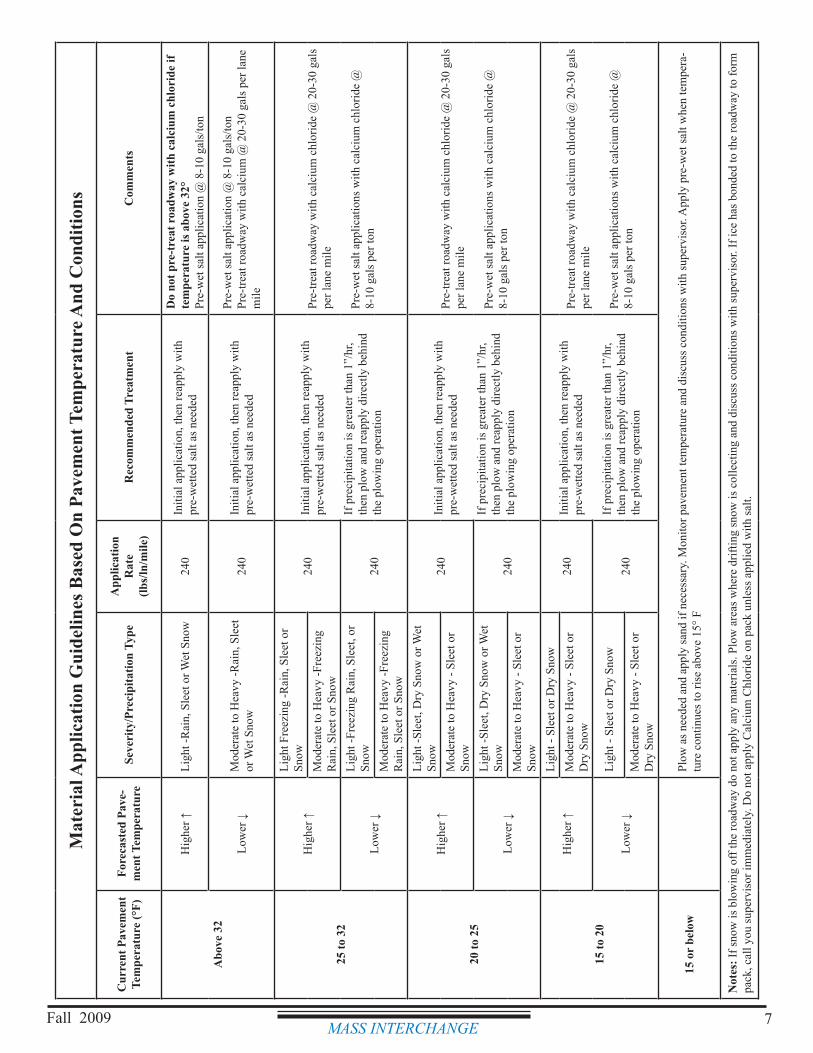
MASS INTERCHANGEFall 2009 7
Mat
eria
l App
licat
ion
Gui
delin
es B
ased
On
Pave
men
t Tem
pera
ture
And
Con
ditio
ns
Cur
rent
Pav
emen
t Te
mpe
ratu
re (°
F)Fo
reca
sted
Pav
e-m
ent T
empe
ratu
reSe
veri
ty/P
reci
pita
tion
Type
App
licat
ion
Rat
e(lb
s/ln
/mile
)R
ecom
men
ded
Trea
tmen
tC
omm
ents
Abo
ve 3
2
Hig
her ↑
Ligh
t -R
ain,
Sle
et o
r Wet
Sno
w24
0In
itial
app
licat
ion,
then
reap
ply
with
pr
e-w
ette
d sa
lt as
nee
ded
Do
not p
re-t
reat
roa
dway
with
cal
cium
chl
orid
e if
tem
pera
ture
is a
bove
32°
Pre-
wet
salt
appl
icat
ion
@ 8
-10
gals
/ton
Low
er ↓
Mod
erat
e to
Hea
vy -R
ain,
Sle
et
or W
et S
now
240
Initi
al a
pplic
atio
n, th
en re
appl
y w
ith
pre-
wet
ted
salt
as n
eede
d
Pre-
wet
salt
appl
icat
ion
@ 8
-10
gals
/ton
Pre-
treat
road
way
with
cal
cium
@ 2
0-30
gal
s per
lane
m
ile
25 to
32
Hig
her ↑
Ligh
t Fre
ezin
g -R
ain,
Sle
et o
r Sn
ow24
0In
itial
app
licat
ion,
then
reap
ply
with
pr
e-w
ette
d sa
lt as
nee
ded
If p
reci
pita
tion
is g
reat
er th
an 1
”/hr
, th
en p
low
and
reap
ply
dire
ctly
beh
ind
the
plow
ing
oper
atio
n
Pre-
treat
road
way
with
cal
cium
chl
orid
e @
20-
30 g
als
per l
ane
mile
Pre-
wet
salt
appl
icat
ions
with
cal
cium
chl
orid
e @
8-
10 g
als p
er to
n
Mod
erat
e to
Hea
vy -F
reez
ing
Rai
n, S
leet
or S
now
Low
er ↓
Ligh
t -Fr
eezi
ng R
ain,
Sle
et, o
r Sn
ow24
0M
oder
ate
to H
eavy
-Fre
ezin
g R
ain,
Sle
et o
r Sno
w
20 to
25
Hig
her ↑
Ligh
t -Sl
eet,
Dry
Sno
w o
r Wet
Sn
ow24
0In
itial
app
licat
ion,
then
reap
ply
with
pr
e-w
ette
d sa
lt as
nee
ded
If p
reci
pita
tion
is g
reat
er th
an 1
”/hr
, th
en p
low
and
reap
ply
dire
ctly
beh
ind
the
plow
ing
oper
atio
n
Pre-
treat
road
way
with
cal
cium
chl
orid
e @
20-
30 g
als
per l
ane
mile
Pre-
wet
salt
appl
icat
ions
with
cal
cium
chl
orid
e @
8-
10 g
als p
er to
n
Mod
erat
e to
Hea
vy -
Slee
t or
Snow
Low
er ↓
Ligh
t -Sl
eet,
Dry
Sno
w o
r Wet
Sn
ow24
0M
oder
ate
to H
eavy
- Sl
eet o
r Sn
ow
15 to
20
Hig
her ↑
Ligh
t - S
leet
or D
ry S
now
240
Initi
al a
pplic
atio
n, th
en re
appl
y w
ith
pre-
wet
ted
salt
as n
eede
d
If p
reci
pita
tion
is g
reat
er th
an 1
”/hr
, th
en p
low
and
reap
ply
dire
ctly
beh
ind
the
plow
ing
oper
atio
n
Pre-
treat
road
way
with
cal
cium
chl
orid
e @
20-
30 g
als
per l
ane
mile
Pre-
wet
salt
appl
icat
ions
with
cal
cium
chl
orid
e @
8-
10 g
als p
er to
n
Mod
erat
e to
Hea
vy -
Slee
t or
Dry
Sno
w
Low
er ↓
Ligh
t - S
leet
or D
ry S
now
240
Mod
erat
e to
Hea
vy -
Slee
t or
Dry
Sno
w
15 o
r be
low
Plow
as n
eede
d an
d ap
ply
sand
if n
eces
sary
. Mon
itor p
avem
ent t
empe
ratu
re a
nd d
iscu
ss c
ondi
tions
with
supe
rvis
or. A
pply
pre
-wet
salt
whe
n te
mpe
ra-
ture
con
tinue
s to
rise
abov
e 15
° F
Not
es: I
f sno
w is
blo
win
g of
f the
road
way
do
not a
pply
any
mat
eria
ls. P
low
are
as w
here
drif
ting
snow
is c
olle
ctin
g an
d di
scus
s con
ditio
ns w
ith su
perv
isor
. If i
ce h
as b
onde
d to
the
road
way
to fo
rm
pack
, cal
l you
supe
rvis
or im
med
iate
ly. D
o no
t app
ly C
alci
um C
hlor
ide
on p
ack
unle
ss a
pplie
d w
ith sa
lt.
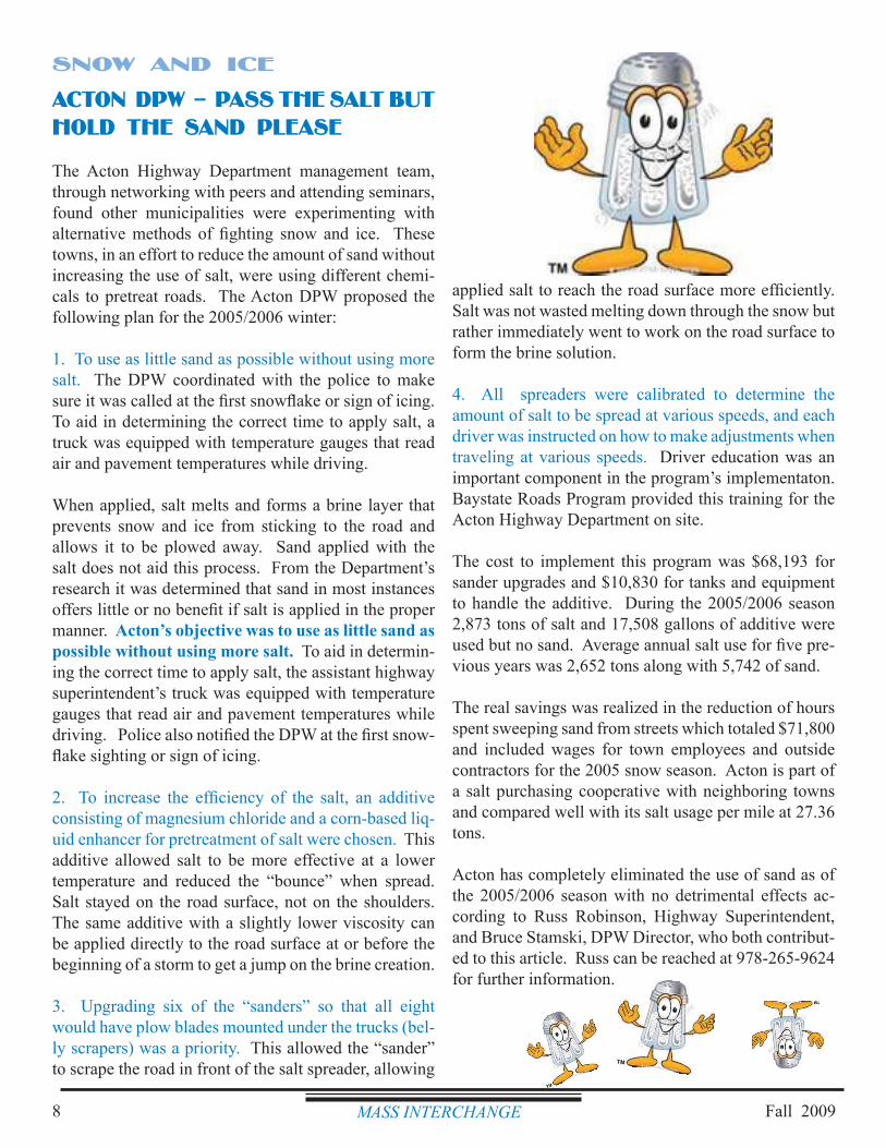
Fall 2009MASS INTERCHANGE8
applied salt to reach the road surface more efficiently. Salt was not wasted melting down through the snow but rather immediately went to work on the road surface to form the brine solution.
4. All spreaders were calibrated to determine the amount of salt to be spread at various speeds, and each driver was instructed on how to make adjustments when traveling at various speeds. Driver education was an important component in the program’s implementaton. Baystate Roads Program provided this training for the Acton Highway Department on site.
The cost to implement this program was $68,193 for sander upgrades and $10,830 for tanks and equipment to handle the additive. During the 2005/2006 season 2,873 tons of salt and 17,508 gallons of additive were used but no sand. Average annual salt use for five pre-vious years was 2,652 tons along with 5,742 of sand.
The real savings was realized in the reduction of hours spent sweeping sand from streets which totaled $71,800 and included wages for town employees and outside contractors for the 2005 snow season. Acton is part of a salt purchasing cooperative with neighboring towns and compared well with its salt usage per mile at 27.36 tons.
Acton has completely eliminated the use of sand as of the 2005/2006 season with no detrimental effects ac-cording to Russ Robinson, Highway Superintendent, and Bruce Stamski, DPW Director, who both contribut-ed to this article. Russ can be reached at 978-265-9624 for further information.
ACTON DPW -- PASS THE SALT BUT HOLD THE SAND PLEASE
The Acton Highway Department management team, through networking with peers and attending seminars, found other municipalities were experimenting with alternative methods of fighting snow and ice. These towns, in an effort to reduce the amount of sand without increasing the use of salt, were using different chemi-cals to pretreat roads. The Acton DPW proposed the following plan for the 2005/2006 winter:
1. To use as little sand as possible without using more salt. The DPW coordinated with the police to make sure it was called at the first snowflake or sign of icing. To aid in determining the correct time to apply salt, a truck was equipped with temperature gauges that read air and pavement temperatures while driving.
When applied, salt melts and forms a brine layer that prevents snow and ice from sticking to the road and allows it to be plowed away. Sand applied with the salt does not aid this process. From the Department’s research it was determined that sand in most instances offers little or no benefit if salt is applied in the proper manner. Acton’s objective was to use as little sand as possible without using more salt. To aid in determin-ing the correct time to apply salt, the assistant highway superintendent’s truck was equipped with temperature gauges that read air and pavement temperatures while driving. Police also notified the DPW at the first snow-flake sighting or sign of icing.
2. To increase the efficiency of the salt, an additive consisting of magnesium chloride and a corn-based liq-uid enhancer for pretreatment of salt were chosen. This additive allowed salt to be more effective at a lower temperature and reduced the “bounce” when spread. Salt stayed on the road surface, not on the shoulders. The same additive with a slightly lower viscosity can be applied directly to the road surface at or before the beginning of a storm to get a jump on the brine creation.
3. Upgrading six of the “sanders” so that all eight would have plow blades mounted under the trucks (bel-ly scrapers) was a priority. This allowed the “sander” to scrape the road in front of the salt spreader, allowing
SNOW AND ICE
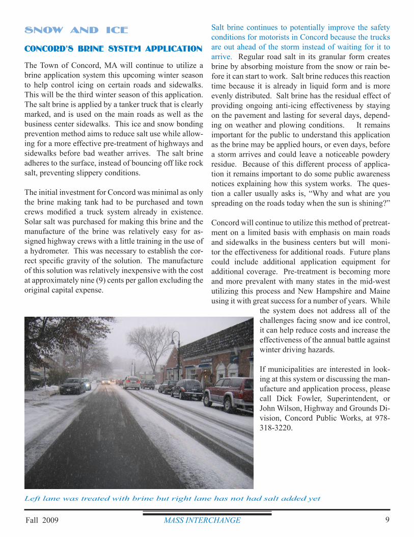
Fall 2009 MASS INTERCHANGE 9
Salt brine continues to potentially improve the safety conditions for motorists in Concord because the trucks are out ahead of the storm instead of waiting for it to arrive. Regular road salt in its granular form creates brine by absorbing moisture from the snow or rain be-fore it can start to work. Salt brine reduces this reaction time because it is already in liquid form and is more evenly distributed. Salt brine has the residual effect of providing ongoing anti-icing effectiveness by staying on the pavement and lasting for several days, depend-ing on weather and plowing conditions. It remains important for the public to understand this application as the brine may be applied hours, or even days, before a storm arrives and could leave a noticeable powdery residue. Because of this different process of applica-tion it remains important to do some public awareness notices explaining how this system works. The ques-tion a caller usually asks is, “Why and what are you spreading on the roads today when the sun is shining?”
Concord will continue to utilize this method of pretreat-ment on a limited basis with emphasis on main roads and sidewalks in the business centers but will moni-tor the effectiveness for additional roads. Future plans could include additional application equipment for additional coverage. Pre-treatment is becoming more and more prevalent with many states in the mid-west utilizing this process and New Hampshire and Maine using it with great success for a number of years. While
the system does not address all of the challenges facing snow and ice control, it can help reduce costs and increase the effectiveness of the annual battle against winter driving hazards.
If municipalities are interested in look-ing at this system or discussing the man-ufacture and application process, please call Dick Fowler, Superintendent, or John Wilson, Highway and Grounds Di-vision, Concord Public Works, at 978-318-3220.
SNOW AND ICE
CONCORD’S BRINE SYSTEM APPLICATION
The Town of Concord, MA will continue to utilize a brine application system this upcoming winter season to help control icing on certain roads and sidewalks. This will be the third winter season of this application. The salt brine is applied by a tanker truck that is clearly marked, and is used on the main roads as well as the business center sidewalks. This ice and snow bonding prevention method aims to reduce salt use while allow-ing for a more effective pre-treatment of highways and sidewalks before bad weather arrives. The salt brine adheres to the surface, instead of bouncing off like rock salt, preventing slippery conditions.
The initial investment for Concord was minimal as only the brine making tank had to be purchased and town crews modified a truck system already in existence. Solar salt was purchased for making this brine and the manufacture of the brine was relatively easy for as-signed highway crews with a little training in the use of a hydrometer. This was necessary to establish the cor-rect specific gravity of the solution. The manufacture of this solution was relatively inexpensive with the cost at approximately nine (9) cents per gallon excluding the original capital expense.
Left lane was treated with brine but right lane has not had salt added yet
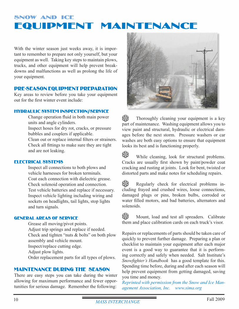
Fall 200910
EQUIPMENT MAINTENANCE
With the winter season just weeks away, it is impor-tant to remember to prepare not only yourself, but your equipment as well. Taking key steps to maintain plows, trucks, and other equipment will help prevent break-downs and malfunctions as well as prolong the life of your equipment.
PRE-SEASON EQUIPMENT PREPARATIONKey areas to review before you take your equipment out for the first winter event include:
HYDRAULIC SYSTEM INSPECTION/SERVICE Change operation fluid in both main power units and angle cylinders. Inspect hoses for dry rot, cracks, or pressure bubbles and couplers if applicable. Clean out or replace internal filters or strainers. Check all fittings to make sure they are tight and are not leaking.
ELECTRICAL SYSTEMS Inspect all connections to both plows and vehicle harnesses for broken terminals. Coat each connection with dielectric grease. Check solenoid operation and connection. Test vehicle batteries and replace if necessary. Inspect vehicle lighting including wiring and sockets on headlights, tail lights, stop lights and turn signals.
GENERAL AREAS OF SERVICE Grease all moving/pivot points. Adjust trip springs and replace if needed. Check and tighten “nuts & bolts” on both plow assembly and vehicle mount. Inspect/replace cutting edge. Adjust plow lights. Order replacement parts for all types of plows.
MAINTENANCE DURING THE SEASONThere are easy steps you can take during the winter allowing for maximum performance and fewer oppor-tunities for serious damage. Remember the following:
SNOW AND ICE
Thoroughly cleaning your equipment is a key part of maintenance. Washing equipment allows you to view paint and structural, hydraulic or electrical dam-ages before the next storm. Pressure washers or car washes are both easy options to ensure that equipment looks its best and is functioning properly.
While cleaning, look for structural problems. Cracks are usually first shown by paint/powder coat cracking and rusting at joints. Look for bent, twisted or distorted parts and make notes for scheduling repairs.
Regularly check for electrical problems in-cluding frayed and crushed wires, loose connections, damaged plugs or pins, broken bulbs, corroded or water filled motors, and bad batteries, alternators and solenoids.
Mount, load and test all spreaders. Calibrate them and place calibration cards on each truck’s visor.
Repairs or replacements of parts should be taken care of quickly to prevent further damage. Preparing a plan or checklist to maintain your equipment after each major event is a good way to guarantee that it is perform-ing correctly and safely when needed. Salt Institute’s Snowfighter’s Handbook has a good template for this. Spending time before, during and after each season will help prevent equipment from getting damaged, saving you time and money.Reprinted with permission from the Snow and Ice Man-agement Association, Inc. www.sima.org
MASS INTERCHANGE
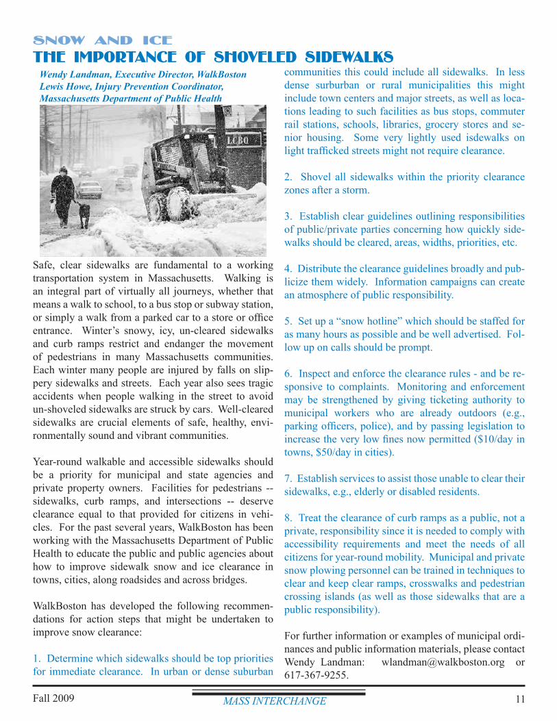
MASS INTERCHANGE 11
communities this could include all sidewalks. In less dense surburban or rural municipalities this might include town centers and major streets, as well as loca-tions leading to such facilities as bus stops, commuter rail stations, schools, libraries, grocery stores and se-nior housing. Some very lightly used isdewalks on light trafficked streets might not require clearance.
2. Shovel all sidewalks within the priority clearance zones after a storm.
3. Establish clear guidelines outlining responsibilities of public/private parties concerning how quickly side-walks should be cleared, areas, widths, priorities, etc.
4. Distribute the clearance guidelines broadly and pub-licize them widely. Information campaigns can create an atmosphere of public responsibility.
5. Set up a “snow hotline” which should be staffed for as many hours as possible and be well advertised. Fol-low up on calls should be prompt.
6. Inspect and enforce the clearance rules - and be re-sponsive to complaints. Monitoring and enforcement may be strengthened by giving ticketing authority to municipal workers who are already outdoors (e.g., parking officers, police), and by passing legislation to increase the very low fines now permitted ($10/day in towns, $50/day in cities).
7. Establish services to assist those unable to clear their sidewalks, e.g., elderly or disabled residents.
8. Treat the clearance of curb ramps as a public, not a private, responsibility since it is needed to comply with accessibility requirements and meet the needs of all citizens for year-round mobility. Municipal and private snow plowing personnel can be trained in techniques to clear and keep clear ramps, crosswalks and pedestrian crossing islands (as well as those sidewalks that are a public responsibility).
For further information or examples of municipal ordi-nances and public information materials, please contact Wendy Landman: [email protected] or 617-367-9255.
Safe, clear sidewalks are fundamental to a working transportation system in Massachusetts. Walking is an integral part of virtually all journeys, whether that means a walk to school, to a bus stop or subway station, or simply a walk from a parked car to a store or office entrance. Winter’s snowy, icy, un-cleared sidewalks and curb ramps restrict and endanger the movement of pedestrians in many Massachusetts communities. Each winter many people are injured by falls on slip-pery sidewalks and streets. Each year also sees tragic accidents when people walking in the street to avoid un-shoveled sidewalks are struck by cars. Well-cleared sidewalks are crucial elements of safe, healthy, envi-ronmentally sound and vibrant communities.
Year-round walkable and accessible sidewalks should be a priority for municipal and state agencies and private property owners. Facilities for pedestrians -- sidewalks, curb ramps, and intersections -- deserve clearance equal to that provided for citizens in vehi-cles. For the past several years, WalkBoston has been working with the Massachusetts Department of Public Health to educate the public and public agencies about how to improve sidewalk snow and ice clearance in towns, cities, along roadsides and across bridges.
WalkBoston has developed the following recommen-dations for action steps that might be undertaken to improve snow clearance:
1. Determine which sidewalks should be top priorities for immediate clearance. In urban or dense suburban
Wendy Landman, Executive Director, WalkBostonLewis Howe, Injury Prevention Coordinator,Massachusetts Department of Public Health
THE IMPORTANCE OF SHOVELED SIDEWALKSSNOW AND ICE
Fall 2009
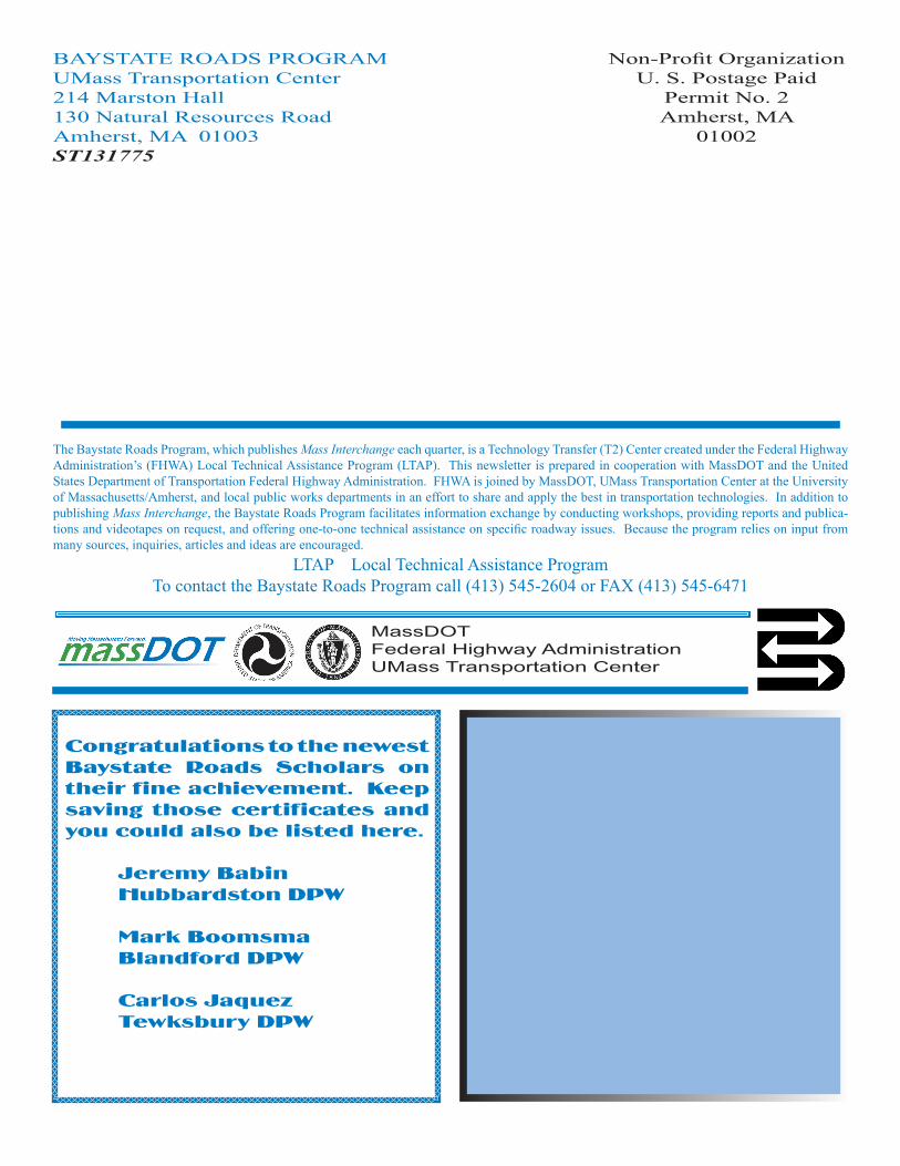
in this issue -- SNOW & ICEMassachusetts Department of Transportation (MassDOT) Arrives............1Regional ITS Architectures..........................2Greg Rounseville, Master Roads Scholar...3What is Anti-Icing?............................................4Depot Maintenance..........................................5Chemical Application Guidelines................6Material Application Guidelines 2009......7Acton DPW - Hold the Sand............................8Concord DPW - Brine System..........................9Equipment Maintenance..............................10Importance of Shoveled Sidewalks..........11
MassDOTFederal Highway AdministrationUMass Transportation Center
The Baystate Roads Program, which publishes Mass Interchange each quarter, is a Technology Transfer (T2) Center created under the Federal Highway Administration’s (FHWA) Local Technical Assistance Program (LTAP). This newsletter is prepared in cooperation with MassDOT and the United States Department of Transportation Federal Highway Administration. FHWA is joined by MassDOT, UMass Transportation Center at the University of Massachusetts/Amherst, and local public works departments in an effort to share and apply the best in transportation technologies. In addition to publishing Mass Interchange, the Baystate Roads Program facilitates information exchange by conducting workshops, providing reports and publica-tions and videotapes on request, and offering one-to-one technical assistance on specific roadway issues. Because the program relies on input from many sources, inquiries, articles and ideas are encouraged.
LTAP Local Technical Assistance ProgramTo contact the Baystate Roads Program call (413) 545-2604 or FAX (413) 545-6471
BAYSTATE ROADS PROGRAMUMass Transportation Center214 Marston Hall130 Natural Resources RoadAmherst, MA 01003ST131775
Non-Profit OrganizationU. S. Postage Paid
Permit No. 2Amherst, MA
01002
Congratulations to the newest Baystate Roads Scholars on their fine achievement. Keep saving those certificates and you could also be listed here.
Jeremy Babin Hubbardston DPW
Mark Boomsma Blandford DPW
Carlos Jaquez Tewksbury DPW
NPDES Storm Water Management Plan Annual Report – Permit Year 7
Appendix K: TMDLs that have been identified as not applicable to MassDOT
NPDES Storm Water Management Plan Annual Report – Permit Year 7
TMDLs That Are Not Applicable to MassDOT MassDOT has conducted a preliminary review of final total maximum daily loads (TMDLs). Based on this review, MassDOT has identified a number of TMDLs that do not require MassDOT action to be compliant with the MS4 permit. These TMDLs do not have waste load allocations (WLAs) applicable to MassDOT. The WLA contains the loading in the TMDL allocated to permitted discharges. Without a specified WLA there are not actions required for permitted discharges1. The determination that the TMDL does not have a WLA is based on either of the following:
The impaired waterbody’s watershed does not include MassDOT assets within urban areas. In this case, there are no NPDES permitted MassDOT discharges in the watershed to the impaired waterbody. The review of MassDOT urban discharges in TMDL water bodies watersheds is ongoing. Additional water sheds without MassDOT urban assets may be identified in the future.
The TMDL does not contain a waste load allocation (WLA) or the TMDLs WLA is for discharges that do not include storm water discharge from MassDOT.
The attached table lists the TMDLs that MassDOT has identified to date as not having an applicable WLA. As MassDOT continues its review of TMDLs, additional TMDLs that do not have applicable WLAs may be identified. Despite the fact that these TMDLs do not have applicable WLA, as described in the SWMP MassDOT is committed to continuing statewide actions which will protect and improve water quality. In particular, MassDOT will continue to ensure that storm water runoff from our properties does not contribute to water quality impairments by implementing the following BMPs:
BMP 4b: Implementation of MassDEP Storm Water Management Policy BMP 4e, 5A-2, and 5A-3: The MassDOT Storm Water Management Handbook has been developed and is
being continuously improved. BMP 7D: Environmental Site Data Form which will document measures taken to address pollutant of
concern discharged to impaired waterbodies during highway improvement project design BMP 3B-2: Drainage Inventory which will include comprehensive drainage infrastructure mapping of
certain watersheds BMP 7T: Review of Specific Sites for Water Quality Exceedance in Response to Conservation Law
Foundation (CLF) et al. Lawsuit More information on these BMPs is available in the MassDOT Storm Water Management Plan.
1 “Storm water discharges that are regulated under Phase I or Phase II of the NPDES storm water program are point
sources that must be included in the WLA portion of a TMDL. See 40 C.F.R. § 130.2(h).” EPA 2002. Establishing Total Maximum Daily Load (TMDL) Wasteload Allocations (WLAs) for Storm Water Sources and NPDES Permit Requirements Based on Those WLAs. Available at: http://www.epa.gov/npdes/pubs/final-wwtmdl.pdf Also see part 2.2.1c of Draft NH MS4 permit.
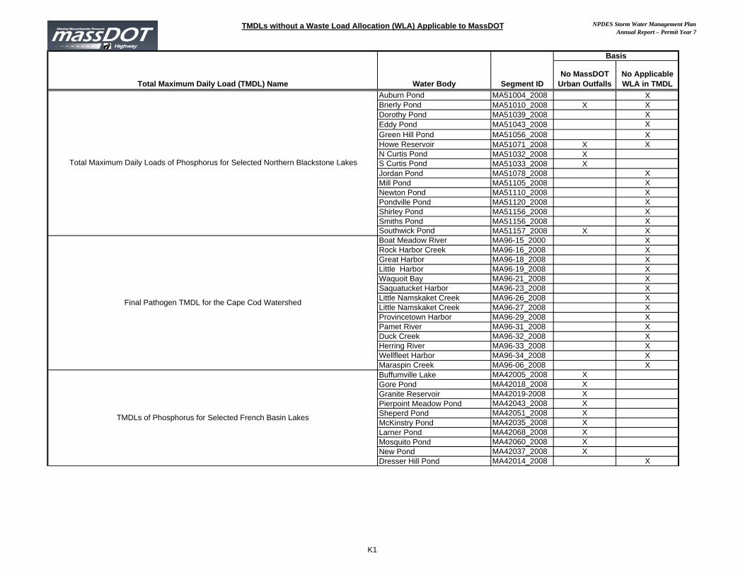
TMDLs without a Waste Load Allocation (WLA) Applicable to MassDOT NPDES Storm Water Management PlanAnnual Report – Permit Year 7
Total Maximum Daily Load (TMDL) Name Water Body Segment IDNo MassDOT
Urban OutfallsNo Applicable WLA in TMDL
Auburn Pond MA51004_2008 XBrierly Pond MA51010_2008 X XDorothy Pond MA51039_2008 XEddy Pond MA51043_2008 XGreen Hill Pond MA51056_2008 XHowe Reservoir MA51071_2008 X XN Curtis Pond MA51032_2008 XS Curtis Pond MA51033_2008 XJordan Pond MA51078_2008 XMill Pond MA51105_2008 XNewton Pond MA51110_2008 XPondville Pond MA51120_2008 XShirley Pond MA51156_2008 XSmiths Pond MA51156_2008 XSouthwick Pond MA51157_2008 X XBoat Meadow River MA96-15_2000 XRock Harbor Creek MA96-16_2008 XGreat Harbor MA96-18_2008 XLittle Harbor MA96-19_2008 XWaquoit Bay MA96-21_2008 XSaquatucket Harbor MA96-23_2008 XLittle Namskaket Creek MA96-26_2008 XLittle Namskaket Creek MA96-27_2008 XProvincetown Harbor MA96-29_2008 XPamet River MA96-31_2008 XDuck Creek MA96-32_2008 XHerring River MA96-33_2008 XWellfleet Harbor MA96-34_2008 XMaraspin Creek MA96-06_2008 XBuffumville Lake MA42005_2008 XGore Pond MA42018_2008 XGranite Reservoir MA42019-2008 XPierpoint Meadow Pond MA42043_2008 XSheperd Pond MA42051_2008 XMcKinstry Pond MA42035_2008 XLarner Pond MA42068_2008 XMosquito Pond MA42060_2008 XNew Pond MA42037_2008 XDresser Hill Pond MA42014_2008 X
Basis
Total Maximum Daily Loads of Phosphorus for Selected Northern Blackstone Lakes
Final Pathogen TMDL for the Cape Cod Watershed
TMDLs of Phosphorus for Selected French Basin Lakes
K1
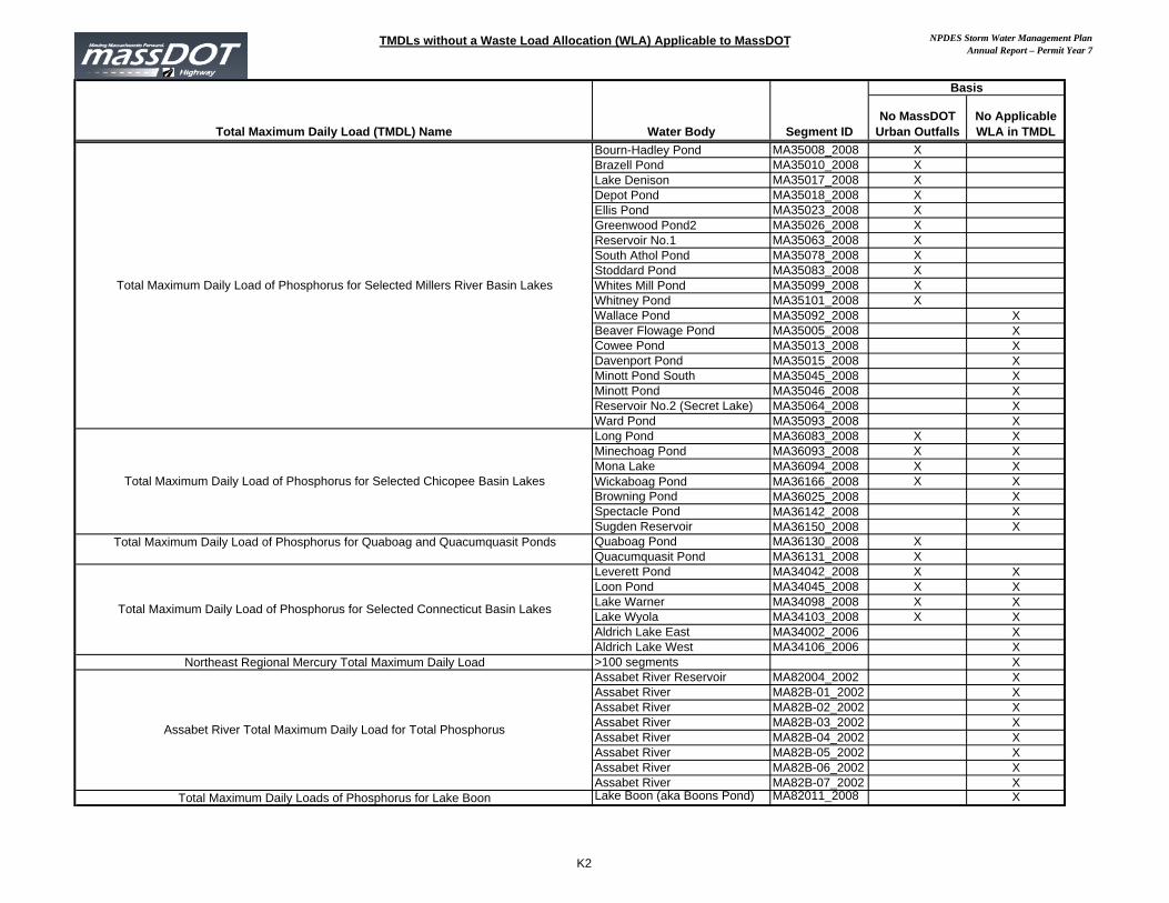
TMDLs without a Waste Load Allocation (WLA) Applicable to MassDOT NPDES Storm Water Management PlanAnnual Report – Permit Year 7
Total Maximum Daily Load (TMDL) Name Water Body Segment IDNo MassDOT
Urban OutfallsNo Applicable WLA in TMDL
Basis
Bourn-Hadley Pond MA35008_2008 XBrazell Pond MA35010_2008 XLake Denison MA35017_2008 XDepot Pond MA35018_2008 XEllis Pond MA35023_2008 XGreenwood Pond2 MA35026_2008 XReservoir No.1 MA35063_2008 XSouth Athol Pond MA35078_2008 XStoddard Pond MA35083_2008 XWhites Mill Pond MA35099_2008 XWhitney Pond MA35101_2008 XWallace Pond MA35092_2008 XBeaver Flowage Pond MA35005_2008 XCowee Pond MA35013_2008 XDavenport Pond MA35015_2008 XMinott Pond South MA35045_2008 XMinott Pond MA35046_2008 XReservoir No.2 (Secret Lake) MA35064_2008 XWard Pond MA35093_2008 XLong Pond MA36083_2008 X XMinechoag Pond MA36093_2008 X XMona Lake MA36094_2008 X XWickaboag Pond MA36166_2008 X XBrowning Pond MA36025_2008 XSpectacle Pond MA36142_2008 XSugden Reservoir MA36150_2008 XQuaboag Pond MA36130_2008 XQuacumquasit Pond MA36131_2008 XLeverett Pond MA34042_2008 X XLoon Pond MA34045_2008 X XLake Warner MA34098_2008 X XLake Wyola MA34103_2008 X XAldrich Lake East MA34002_2006 XAldrich Lake West MA34106_2006 X
Northeast Regional Mercury Total Maximum Daily Load >100 segments XAssabet River Reservoir MA82004_2002 XAssabet River MA82B-01_2002 XAssabet River MA82B-02_2002 XAssabet River MA82B-03_2002 XAssabet River MA82B-04_2002 XAssabet River MA82B-05_2002 XAssabet River MA82B-06_2002 XAssabet River MA82B-07_2002 X
Total Maximum Daily Loads of Phosphorus for Lake Boon Lake Boon (aka Boons Pond) MA82011_2008 X
Total Maximum Daily Load of Phosphorus for Selected Millers River Basin Lakes
Total Maximum Daily Load of Phosphorus for Selected Chicopee Basin Lakes
Assabet River Total Maximum Daily Load for Total Phosphorus
Total Maximum Daily Load of Phosphorus for Quaboag and Quacumquasit Ponds
Total Maximum Daily Load of Phosphorus for Selected Connecticut Basin Lakes
K2