Embed Size (px)
Citation preview
NPS Metadata Tool Help Files - Table of Contents
● About extension● Getting started
❍ Overview of extension ❍ Installing the extension ❍ Uninstalling extension ❍ Manual uninstall ❍ Using the help file
● Metadata Tools ❍ General notes about extension
■ Metadata within ArcCatalog ■ Metadata fixes ■ Selecting files and directories ■ Metadata formats ■ NPS Stylesheets ■ NBII metadata in ArcCatalog ■ Geodatabase file names
❍ Importing data and metadata ■ Import E00 files tool ■ Import metadata tool ■ Update with XML template
❍ Exporting data and metadata ■ Export E00 tool ■ Export metadata tool ■ Parse with MP tool ■ Create metadata template
❍ Editing metadata ■ Spell check metadata ■ Find and replace metadata ■ Manually edit metadata ■ Delete metadata
❍ Cataloging metadata ❍ Searching metadata
● Troubleshooting
AboutCaptured from HTML Help source files on September 13, 2004.

About extension...
Current Version 1.5
What's new in 1.5 (built on 8/16/04)● Added ability to handle metadata in Personal Geodatabases to all appropriate tools (SDE or
enterprise geodatabases are still not supported)● Tested and modified tools to be functional in ArcGIS 9● Fixed syntax error in NPS stylesheets● Added Find and Replace tool for metadata● Added Manually edit XML tool (to edit metadata within a geodatabase)● Added Delete metadata tool● Added stand-alone metadata functionality to Parse with MP tool● Added "output folder" option to Parse with MP and Export Metadata● Added settings window to Export Metadata● Added report to Update with XML Template● Fixed error with Metadata Catalog tool for machines with older MDAC (data access) libraries● Rearranged tool menu
What's new in 1.4 (built on 1/8/04)● Added metadata spell checker tool● Added optional HTML formatted error output from MP using Parse with MP● Fixed NPS NBII stylesheet to display all NBII tags● Fixed metadata parse problem with XML contains <!DOCTYPE header● Fixed error in Parse with MP when file name contains spaces● Fixed error in Parse with MP where metadata from shapefiles and images are overwritten
Created by Midwest Region GIS Technical Support Office National Park Service B102 Steenbock 550 Babcock Drive University of Wisconsin-Madison Madison, WI 53706
DisclaimerThis software is provide "as is" and the National Park Service gives no warranty, expressed or implied, as

to the accuracy, reliability, or completeness of this software. Although this software has been processed successfully on a computer system at the National Park Service, no warranty expressed or implied is made regarding the functioning of the software on another system or for general or scientific purposes, nor shall the act of distribution constitute any such warranty. This disclaimer applies both to individual use of the software and aggregate use with other software.

Getting startedWelcome to the help file for the NPS Metadata Tools. This file contains information on how to start using the extension, general information about metadata within ArcCatalog, and specific guidance for using each of the tools in the extension.
For those new to the extension and extensions in ArcCatalog● Overview of the extension and its functions● How to install the extension● How to uninstall the extension● Manually uninstalling the extension (if automated fails)● How to open and use this help file
To learn more about metadata within ArcCatalog see● Metadata within ArcCatalog● Metadata formats● NBII metadata in ArcCatalog
To find out more about a specific tool see● Metadata tools overview● Selecting files and folders for use with tools
To obtain support for these tools:● First look at our troubleshooting page● If that doesn't help, then contact:
Eric [email protected]

OverviewManaging metadata can be a daunting task. With the proliferation of GIS data, however, the need to effectively document and track this data is more important than ever. While this task in considerably easier in ArcGIS's ArcCatalog, there are still a limited number of tools for managing large sets of metadata. The NPS Metadata Tools Extension expands on these tools in the following ways:
Importing metadataImporting existing metadata into ArcCatalog. Batch import from SGML, text metadata files, or from XML templates. Also, batch import only specific parts of a metadata template. For example, to change contact information for several datasets.
Exporting metadataExporting existing metadata from ArcCatalog for sharing or incorporation into enterprise metadata database. Export metadata to SGML, text, HTML, or XML using ArcCatalog's or MP's exporter. NOTE: Use the Parse with MP tool for creating HTML pages to post to the NPS GIS Clearinghouse.
Parsing and conversionValidating metadata through parsing to ensure that it is compliant with FGDC standards and their extensions, or convert one metadata format to any other. Uses MP (USGS's metadata parser) within ArcCatalog to examine metadata errors and use extensions to the FGDC standard, such as the NBII. The tools allow for batch running of MP with or without a configuration file.
Editing metadataTools to spell check metadata files, manually edit XML files within a text editor, find and replace text across multiple metadata files, and delete metadata files.
Fix ArcGIS 8 errorsFixes several ArcGIS 8 metadata errors including table attributes. See Metadata fixes for more information.
Metadata stylesheetsSeveral NPS-style stylesheets are added to ArcCatalog to view and print summary and NBII metadata.
OtherSearch metadata fields easily.Create an Access database of summary metadata.Batch import E00 files.Import, view, and export NBII compliant metadata.
Overall, the extension helps importing existing and legacy metadata into ArcCatalog and getting metadata to parse with MP.
Notes:

● Scripts were developed in Visual Basic 6 and tested on ArcGIS 8.3. All tools should work with all prior versions of ArcGIS 8.x and with ArcGIS 9.0
● None of these tools were developed or tested with enterprise or SDE geodatabases. While they should not affect or modify enterprise geodatabases, please use with caution in such environments.
● Source code for the extension is available. See the extension web site for links to the extension's most recent source files.

Installing the extension
1. Close any open ArcGIS applications, e.g. ArcCatalog or ArcMap. Uninstall any previous version of the NPS Metadata Extension. Note: In both Windows 2000 and XP, please install the latest service packs before installing the extension.
2. Log on to the system with an account with Administrator privileges.3. Locate and double-click on the NPSMetadata_1.x.exe file. The installation setup window will
open providing information about the install, details for the current release, and will ask you to agree to the license agreement. For the remaining install wizard, default values for file locations, etc. will work fine.
4. After the install finishes, start ArcCatalog. If this is the first time you've installed the extension, the toolbar will first appear grayed-out. To get the extension toolbar to appear, first select Tools -> Extensions… and check the box next to NPS Metadata Extension and close the Extension window. Next, right-click the toolbar in ArcCatalog and select the NPS Metadata Menu from the popup menu.
The first time the extension runs, it will add E00, SGML, and TXT files to the list of displayed file types within ArcCatalog. This is necessary to be able to select these files for the extension's tools.
We also suggest turning off the automatic update of metadata within ArcCatalog. To do so, go to Tools -> Options... within ArcCatalog. In the window that opens, click on the Metadata tab and uncheck the box next to "Automatically update metadata..."
See also● Uninstalling the extension● NPS GIS Applications (to check for latest version of the extension)

Uninstalling extensionIn Windows 2000, go to Start -> Settings -> Control Panel and double-click on the Add/Remove Programs. In Windows XP, go to Start -> Control Panel -> Add or Remove Programs. Scroll down to the NPS Metadata Tools entry and select it. Click on the Change/Remove button. All files and registry entries for the extension will be removed in the uninstall. If for some reason this doesn't work, see the manual uninstall instructions.
Note: Uninstalling the extension is required before upgrading to a more recent version.

Manually uninstalling extension
1. Close any open ArcGIS applications, e.g. ArcCatalog or ArcMap.2. First try the automated uninstall. Only if this doesn’t work continue.3. Open the program Categories.exe in the ArcGIS bin folder (something like "C:\arcgis\arcexe83
\Bin"). Click on the folders to open and remove the following objects:
Folder Object
ESRI GX Command Bars NPSMetadata.* (all with this prefix)
ESRI GX Commands NPSMetadata.* (all with this prefix)
ESRI GX Extensions NPSMetadata.clsNPSExtension
Metadata Importers NPSMetadata.clsXMLMetadataImport
This removes any references to NPS Metadata objects from ArcGIS. 4. Go to Start -> Run. In this dialog, type regedit. Once the Registry Editor opens, go to the
following keys: HKEY_CURRENT_USER\Software\NPS and HKEY_LOCAL_MACHINE\Software\NPS. Select and delete the Metadata key from each folder.
5. Delete the NPSMetadata folder from "C:\Program Files".
See also● Uninstalling the extension

Using the help fileThe information within this help file can be accessed in two ways. First, the user can choose Help from the Metadata menu in the NPS Metadata toolbar. The help file will be opened to the Table of Contents.
Second, the user can use the What's This? button to retrieve help on a specific tool. Click on the What's This? button and then click on the tool or menu option of interest. The help file will open to the page describing that particular tool.

Metadata ToolsThe extension's toolbar contains menu items for all of the functions contained within the extension. Note: You'll find the toolbar either among the toolbars at the top of the ArcCatalog window or floating above the window as an detached toolbar. If you don't see either, see Troubleshooting for more help.
From top to bottom, the menu items are grouped into import tools, export tools, edit tools, and miscellaneous tools as follows:
Import tools
❍ Import ESRI Export (E00) files to coverages, grids, or tins
❍ Import metadata files from a variety of formats (*.txt, *.sgml, and *.html)
❍ Update metadata with an XML template to capture specific elements from a templateExport tools

❍ Export ESRI Export (E00) files from coverages, grids, or tins (ArcGIS Workstation License required)
❍ Export metadata file to a variety of formats (*.txt, *.sgml, *.html, and *.xml)
❍ Parse/export with MP to validate and convert metadata (using USGS's metadata parser)
❍ Create XML metadata template for import to new or undocumented datasetsEdit tools
❍ Spell check metadata with Microsoft Word spell checking engine
❍ Find and Replace text within metadata files
❍ Manually edit XML metadata in a text editor
❍ Deleted metadata for a dataset(s)Miscellaneous tools
❍ Create catalog of metadata in an Access database
❍ Search metadata elements for specific text string

Metadata within ArcCatalogMetadata within ArcCatalog is stored exclusively as Extensible Markup Language (XML) files. For each dataset, an XML metadata file is either stored in the same folder (e.g. shapefiles, SID images), within a dataset folder (e.g. grids, coverages), or within a database (e.g. personal geodatabases, SDE). For viewing and accessing metadata within ArcCatalog or ArcMap, the applications look for and display these XML files. ArcCatalog uses XML stylesheets to convert these XML files into formatted and easily read documents within the metadata tab of the application.
Getting existing metadata into an XML format that ArcCatalog can use is fairly straightforward if the metadata is FGDC compliant and currently parses with USGS MP (metadata parser) tool. The NPS Metadata Tools include several import tools to convert legacy metadata in text, SGML, and HTML formats into ArcCatalog's XML. See Import metadata tool for more details.
Metadata FixesArcGIS versions 8.1.2, 8.2, and 8.3 have several problems when importing existing metadata. The most severe is the scrambling of table attributes if the number and order of attributes within the metadata file does not exactly match the number and order within the dataset's tables. The two import tools (SGML and TXT) fix these problems upon importing existing metadata. ESRI says that this will be fixed with the next release. The import tools make the following changes:
● Fix attribute order and number. ● Delete the "Metadata imported." processing step that ArcCatalog adds when importing metadata.
(This added processing step doesn't parse in MP.) ● Add an "unspecifiable domain" to the "cover"-ID attribute if it isn't specified within the metadata. ● Automatically synchronize the bounding box for the dataset (update it based on the data).
See Metadata fixes for additional information.
In addition, the Export metadata tool makes the following fixes:
● Removes invalid ASCII characters from exported HTML file.● Removes initial XML tag in exported HTML file if it exists (confuses some browsers).● Rearranges metadata elements to fit FGDC order.
See Export metadata tool and Parse with MP tool for more details.

Metadata fixesSeveral of the tools within the extension make modification to metadata both to correct mistakes made by the internal ArcCatalog tools and to help ensure FGDC compliant metadata. The following are specific changes make by the extension:
Fix attributes (existence and order) metadataWhen importing, ArcCatalog does not match up attributes (or the fields of a table) correctly if there are not equivalent number of attributes in the metadata and in the associated table or if they do not occur in the same order. As a result, the attribute metadata will be missing or under the wrong attribute. The extension's fix is to correctly match table attributes to the imported metadata.
Add missing "unspecified domain"If a dataset contains a "<dataset>-ID" field and is missing a defined domain in the metadata, the domain is automatically set to "unspecifiable domain." Since most users do not use this field for an ID field, this value is appropriate and allows the metadata to parse correctly in MP.
Remove metadata import processing stepWhen importing metadata, ArcCatalog automatically adds a processing step for importing metadata. This processing step doesn't parse correctly with MP. The extension removes this "Metadata imported." processing step.
Missing synchronize attributesThe flags within the XML metadata to automatically synchronize certain elements is missing for the bounding box of the dataset. This fix sets these flags to true to make sure the bounding box matches the dataset. ArcCatalog's synchronizer needs to be used to actually update these fields.
Use of ArcCatalog's metadata synchronizerBoth the attribute and the bounding box fix above require that ArcCatalog's internal synchronizer is run on the metadata. Selecting these options will automatically add this step to the import process.
See also● Import metadata tool

Selecting files and/or foldersMost of the metadata tools operate on the user's current selections in the "tree view" (left window pane) or the "contents view" (right window pane) of ArcCatalog. If one file is selected, the tool will operate only on that file. If multiple files or a folder is selected, the tool will operate on all appropriate files or datasets. The tools become "batch" tools in this second case.
With this batch functionality of most of the metadata tools there also comes some hazards to avoid. When iterating through subdirectories and files, all datasets are operated on with potentially unintended effects. For example, if importing elements from an XML template (Update with XML template tool) and a folder was selected (cases 3 and 4 below), then the tool would try to add XML metadata to all datasets that it encountered within that folder and its subfolders.
Below are examples of different possible selections and what would be operated on.
1. Single file selected within the Contents pane:
In this example, the tool would only operate on the "counties" dataset.2. Multiple file selected within the Contents pane:

In this example, the tool would operate on the selected files (from "bird_survey" to "country") within the Contents pane.
3. Single folder selected within the Contents pane:

In this example, the tool would operate on all files found within the "north_america" folder and its subfolders.
4. Single folder selected within the Tree pane:

In this example, the tool would also operate on all files found within the "north_america" folder and its subfolders.
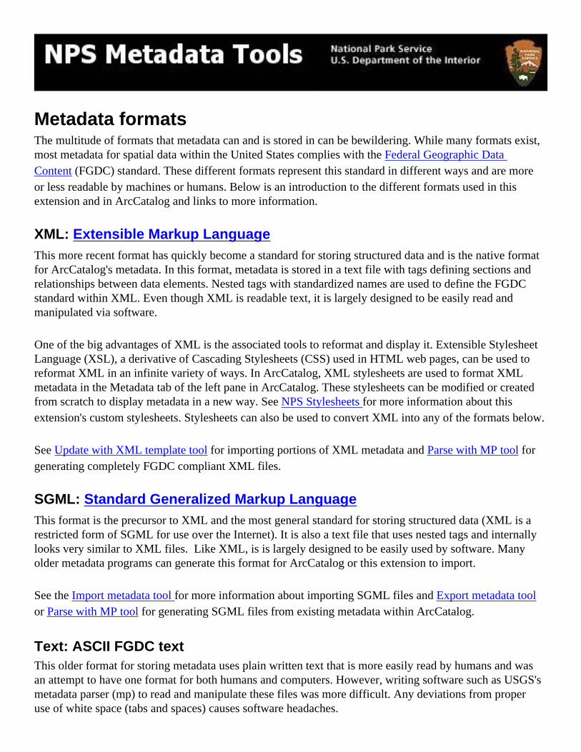
Metadata formatsThe multitude of formats that metadata can and is stored in can be bewildering. While many formats exist, most metadata for spatial data within the United States complies with the Federal Geographic Data Content (FGDC) standard. These different formats represent this standard in different ways and are more or less readable by machines or humans. Below is an introduction to the different formats used in this extension and in ArcCatalog and links to more information.
XML: Extensible Markup LanguageThis more recent format has quickly become a standard for storing structured data and is the native format for ArcCatalog's metadata. In this format, metadata is stored in a text file with tags defining sections and relationships between data elements. Nested tags with standardized names are used to define the FGDC standard within XML. Even though XML is readable text, it is largely designed to be easily read and manipulated via software.
One of the big advantages of XML is the associated tools to reformat and display it. Extensible Stylesheet Language (XSL), a derivative of Cascading Stylesheets (CSS) used in HTML web pages, can be used to reformat XML in an infinite variety of ways. In ArcCatalog, XML stylesheets are used to format XML metadata in the Metadata tab of the left pane in ArcCatalog. These stylesheets can be modified or created from scratch to display metadata in a new way. See NPS Stylesheets for more information about this extension's custom stylesheets. Stylesheets can also be used to convert XML into any of the formats below.
See Update with XML template tool for importing portions of XML metadata and Parse with MP tool for generating completely FGDC compliant XML files.
SGML: Standard Generalized Markup LanguageThis format is the precursor to XML and the most general standard for storing structured data (XML is a restricted form of SGML for use over the Internet). It is also a text file that uses nested tags and internally looks very similar to XML files. Like XML, is is largely designed to be easily used by software. Many older metadata programs can generate this format for ArcCatalog or this extension to import.
See the Import metadata tool for more information about importing SGML files and Export metadata tool or Parse with MP tool for generating SGML files from existing metadata within ArcCatalog.
Text: ASCII FGDC textThis older format for storing metadata uses plain written text that is more easily read by humans and was an attempt to have one format for both humans and computers. However, writing software such as USGS's metadata parser (mp) to read and manipulate these files was more difficult. Any deviations from proper use of white space (tabs and spaces) causes software headaches.

See the Import metadata tool for more information about importing Text files and Export metadata tool or Parse with MP tool for generating Text files from existing metadata within ArcCatalog
HTML: Hypertext Markup LanguageHTML is the standard format for Internet web pages and the preferred format for posting metadata to the web. Once formatted by a web browser, it's also the most human-readable format for metadata.
See more in the Export metadata tool to create HTML files from ArcCatalog's XML stylesheets or the Parse with MP tool to create the standard FDGC HTML and HTML-FAQ style pages.

NPS stylesheetsInstalled with the extension are two NPS metadata stylesheets, NPS and NPS NBII. Stylesheets are used to format and display raw XML files into different views. ArcCatalog includes several built-in stylesheets to display XML metadata in different ways.
To use these stylesheets, first make sure that you have the Metadata toolbar open in ArcCatalog. Right-click the menu bar in ArcCatalog, and make sure the Metadata toolbar is checked.
Next, select a dataset with metadata and click on the Metadata pane and choose "NPS", "NPS NBII", or "FGDC NBII" from the Stylesheet drop-down box. The selected dataset's metadata is displayed using the stylesheet.

For those with the technical expertise, these stylesheets can be modified to expose additional elements or to change the text formatting. All ArcCatalog stylesheets are located in the ArcGIS install folder under "Metadata\Stylesheets", e.g. C:\ArcGIS\Metadata\Stylesheets. See the ArcCatalog Help topics About XML documents and Customizing metadata for more information about creating and customizing stylesheets within ArcCatalog. Note that these NPS stylesheets were written in the 1.0 version of XSL while the ESRI stylesheets were written in an earlier working draft of XSL.
See also● NBII metadata in ArcCatalog for more information about using the NBII metadata extensions with
the metadata tools and ArcCatalog.● Troubleshooting if red Xs appear where graphics ought to within the stylesheets.● For more information about XSL, see the official documentation or a tutorial such as http://www.
w3schools.com/xsl/.

NBII metadata in ArcCatalogThe NBII Metadata Standards, or the Biological Data Profile, define extensions to the FGDC standard for documenting biological data within the National Biological Information Infrastructure. While ArcCatalog out of the box will not recognize or display this extension, the Metadata Tool extension contains tools to import, view, and export metadata that includes these extensions.
Importing NBII metadataNBII metadata can be imported from an XML source using the Import metadata tool within the extension or ArcCatalog's Import button using the XML option (at bottom of the drop-down list). The former will allow you to apply several fixes to ArcCatalog's handling of the import processes. In general, attempting to import from other formats, e.g. text, will not retain the NBII elements in the resulting metadata.
Viewing NBII metadataFirst, make sure that you've installed the NPS stylesheets as described in the extension documentation. Second, make sure that you have the ArcCatalog metadata tool bar displayed (right-click the menu bar and choose "Metadata"). Third, within ArcCatalog, choose the dataset you'd like to view NBII metadata for, select the Metadata tab, and select the "NPS NBII" or "FGDC NBII" stylesheets. All NBII elements that exist within the metadata are displayed within these templates. The former only shows a summary of other FGDC elements while the latter displays them all.
Exporting NBII metadataMetadata can be exported using the Parse metadata with MP tool within the NPS Metadata Extension (works with multiple datasets) or with ArcCatalog's Export button in the metadata tool bar using the XML option (not any of the FGDC options; they'll erase the NBII elements). The Export metadata tool will not retain NBII metadata in its output.
To use the Parse metadata with MP tool, you'll need to specify a configuration file to tell MP to parse the NBII elements. A simple one (NBII.cfg) is included within the NPS Metadata Extension install folder, e.g. "/Program Files/NPS/Metadata" and is printed below. Please see the MP documentation pages for more information about using extensions.
Configuration fileCut and paste the following text into a text editor and save as "NBII.cfg" to use as a configuration file for parsing NBII metadata.

input profile bio
See also● Metadata within ArcCatalog

Geodatabase file name conventionsWhen importing and exporting metadata from a personal geodatabase, the NPS Metadata Tools use a naming convention to create a valid filename for finding a metadata file to import or in creating an output file. The name is constructed by concatenating to the personal geodatabase the name of each subcomponent separated by an underscore.
For example. a metadata file for a feature class within a feature dataset would look like:
gdbPersonal.mdb_fdsDataset_fclFeatureClass.xml
A stand-alone feature class would like like:
gdbPersonal.mdb_fclStandAlone.htm
The procedure ensures a unique file name for each object within a personal geodatabase.
See also● Exporting metadata

Import metadataThe NPS Metadata extension includes several tools to expedite importing existing data and metadata into ArcCatalog. Common tasks possible with the extension include:
● batch importing ESRI export files (*.e00 files). See Import E00 files tool.
● batch importing whole metadata from Standard Generalized Markup Language (*.sgml), ASCII text (*.txt or *.text), and Extensible Markup Language (*.xml) source files. See Import metadata tool.
● update and import specific portions of metadata from an XML template. See Update with XML template tool.
In addition to importing metadata, the batch import tool implements a variety of "fixes" to the way that ArcCatalog imports and handles metadata files. The details of these fixes are outlined in Metadata within ArcCatalog and Metadata fixes sections.
See also● Metadata formats

Import E00 files toolFunction: Batch import of ESRI export files (*.e00).
Tool icon: To enable: Select one or more *.e00 files or a folder to scan.
This tool either imports selected *.e00 file(s) in the contents pane or scans a selected folder for *.e00 files to import. See selections for more details. To chose a default file name for the dataset, this tool uses the file's base name, e.g. "boundary" for "boundary.e00". If this output dataset already exists, the tool confirms overwrite of coverage, grid, or tin with the following dialog:
The user can choose yes or no to overwrite datasets encountered in the import process or choose yes to all to overwrite everything found.
When the tool is finished it generates a report of what it found and the status of the import:

The user can save this report to a text file or click on OK to remove the window.
See also ● Selecting files and directories

Import metadata toolFunction: Batch import of metadata.
Tool icon: To enable: Select one or more datasets or a folder to scan.
Batch import metadata for selected dataset(s) or from selected folder. To find the metadata associated with the dataset, this tool assumes that datasets and metadata share the same base file name, e.g. "roads.sgml" and "roads.shp" in the same directory (see geodatabase naming conventions). If a metadata file can't be found, it asks the user to locate one, e.g. select a template created from the Metadata Template tool. This tool also makes several metadata "fixes" as described in Metadata fixes.
Check or uncheck options within this window to control the import process. For "Fix missing attributes..." and "Set 'synchronize' attribute.." the last option of running ArcCatalog's metadata synchronizer is also required. It will automatically be included if either of the former two options are checked.
Several other windows may appear depending on what the tool encounters. If multiple metadata files exist with the same base name, then the tools asks which metadata file to use:

Select the proper input format to use and click on the check box at the bottom of the dialog to use the same format if multiple files are encountered again.
If metadata for a dataset already exists, the tool confirms overwrite of metadata:
Choose Yes to replace this dataset's metadata or Yes to All to replace this and all subsequent dataset's metadata.
If no import metadata is found, the tool will ask if you'd like to specify another file to use as a template.
At the end of the process, a report will appear showing the results of the import. This report can be saved if needed.

See also● Metadata fixes● Metadata formats● Geodatabase naming conventions● Selecting files and directories

Update with XML template toolFunction: Batch import and update of portions of an XML metadata file.
Tool icon: To enable: Select one or more datasets or a folder to scan.
This is an advanced tool that requires some knowledge of how metadata is stored in the XML format. The tool has the potential to make many difficult to undo changes to metadata. Please read this documentation thoroughly to understand exactly what the tool will do and use the tool with caution.
Import/update selected elements of metadata from an XML source to selected file(s). Very useful for making changes to a selected set of elements of multiple metadata files without impacting other metadata elements, e.g. universally changing contact information. Note: All elements within the selected elements (and sub-elements) of the target metadata file will be replaced by the template information.
This tool is also available under the ArcCatalog metadata import button. If you click on the button in ArcCatalog's metadata toolbar, an NPS XML Template Importer option will be available in the drop-down choices for format.
To use the tool, first select the datasets or folders for which you want to import metadata into. It is metadata for these datasets that will be updated by the elements selected from the XML template. If selecting folders, be aware that all datasets with the folder and its subfolders will be updated.
When invoked, the tool first asks the user to identify a template XML file to use as the source to obtain metadata from. Next, the following window is opened where specific elements from the template XML file can be selected.
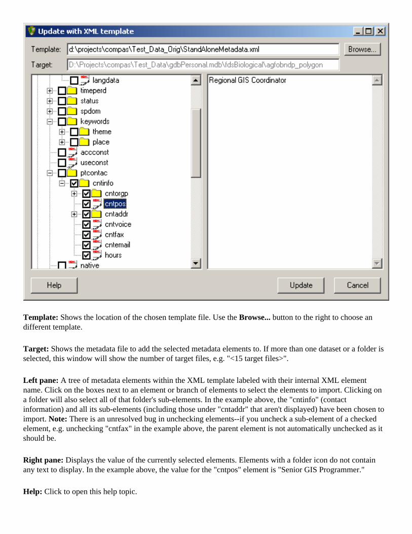
Template: Shows the location of the chosen template file. Use the Browse... button to the right to choose an different template.
Target: Shows the metadata file to add the selected metadata elements to. If more than one dataset or a folder is selected, this window will show the number of target files, e.g. "<15 target files>".
Left pane: A tree of metadata elements within the XML template labeled with their internal XML element name. Click on the boxes next to an element or branch of elements to select the elements to import. Clicking on a folder will also select all of that folder's sub-elements. In the example above, the "cntinfo" (contact information) and all its sub-elements (including those under "cntaddr" that aren't displayed) have been chosen to import. Note: There is an unresolved bug in unchecking elements--if you uncheck a sub-element of a checked element, e.g. unchecking "cntfax" in the example above, the parent element is not automatically unchecked as it should be.
Right pane: Displays the value of the currently selected elements. Elements with a folder icon do not contain any text to display. In the example above, the value for the "cntpos" element is "Senior GIS Programmer."
Help: Click to open this help topic.

Import: Click on this button to start the import process.
When initiated, the tool will replace the selected elements from the template metadata in all of the target metadata. If the selected element is a parent, i.e. contains sub-elements, then all sub-elements under the parent will be wholly replaced in the target metadata. Selecting "citeinfo" as in the example above will ensure that this section will be exactly the same in all target metadata.
When importing enumerated metadata elements such as keywords or processing steps, the text for each element is replaced in the target metadata when there is an exact one-to-one correspondence. In this case, the tool uses the following rules: 1) If the same numbered element exists in the target metadata, it is replaced by the same numbered element from the source. For example, if the third place keyword is selected, it will replace the third place keyword in the target metadata if it has three or more place keywords. 2) If the same numbered element does not exist in the target metadata, then the element will be appended to the end of the target metadata's set. For example, if the third place keyword is selected, it will become the second place keyword if the target only has one place keyword.
If you want to replace all keywords in the target metadata regardless of their number, choose a parent element such as "theme" or "keywords." If you want to replace or add specific keywords, only choose those specific elements, e.g. themekey[2] and/or themekey[5], to import.
Note: Selecting the whole metadata file to import (clicking on the "metadata" box) does not work. This is a known bug with the tool. Please use the Import metadata tool to import complete metadata templates.
See also● Selecting files and directories● Metadata formats

Export metadataThe NPS Metadata extension includes several tools to expedite exporting metadata from ArcCatalog. Common tasks possible with the extension include:
● batch exporting ESRI export files (*.e00 files). See Export E00 files tool.
● batch exporting metadata to Standard Generalized Markup Language (*.sgml), ASCII text (*.txt or *.text), Extensible Markup Language (*.xml), and Hypertext Markup Language (*.html) files. See Export metadata tool.
● batch parsing of metadata with USGS's metadata parser (MP) to all formats supported by MP. Also allows the use of MP configuration files. See Parse with MP tool.
● create metadata template (an *.xml file) from selected dataset for import into other datasets. See Metadata template tool.
See also● Metadata formats
Export E00 toolFunction: Batch export of ESRI export files (*.e00).
Tool icon: To enable: Select one or more datasets or a folder to scan.
This tool creates ESRI export files (*.e00) for valid selected datasets (coverages, grids, and tins) or those within the selected folder and subfolders. By default, the tool uses the dataset name as the name for the output e00 file. For example, the grid entitled "landcover" would yield an output file called "landcover.e00" in the same folder as the grid folder.
If the tool finds existing e00 files, it will ask the user before overwriting the existing files. When completed, the tool will display a report of the export process and show if any errors were encountered.
Notes:
● This tool requires a valid ArcInfo license to run. It uses the somewhat antiquated command line EXPORT command that is only available with a full ArcInfo license. The command is always disabled if the user doesn't have a sufficient license.
● Metadata is retained in e00 files. The XML metadata for a dataset is included in the e00 file and will automatically be added back to the dataset when imported.
See also● Selecting files and directories

Export metadata toolFunction: Batch export of metadata to *.txt, *.sgml, and *.html formats.
Tool icon: To enable: Select one or more datasets or a folder to scan.
This tool exports metadata into three formats: FGDC text file (*.txt), SGML (*.sgml) file, and HTML (*.html) file. If a folder is selected, the tool will confirm before exporting all metadata within the folder. The tool will overwrite any existing metadata files. The exported HTML file will be formatted using the currently selected metadata stylesheet with ArcCatalog. To change this setting, see the help topic in ArcCatalog's Help Changing the metadata's appearance. The Parse with MP tool will export a formatted HTML in either a standardized FGDC or FGDC FAQ look.
Selecting the tool opens the following window:
In this window, select which output formats you'd like the tool to create. By default, the tool will create the exported metadata files in the directory in which the dataset resides. If desirable, select an alternative output directory in which to create the export files.
This tool also makes the following "fixes" to the exported files:
● Removes invalid ASCII characters from exported HTML file (confounds the clearinghouse ISite server).
● Removes initial XML tag in exported HTML file if it exists (confuses some browsers).
Note: This tool will not retain custom metadata tags or extensions, e.g. the NBII Biological Profile. To

retain these tags in output files, please use the Parse with MP tool.
See also● Metadata formats● Selecting files and directories● Geodatabase file name conventions

Parse with MP toolFunction: Batch parsing of metadata files with metadata parser (MP).
Tool icon: To enable: Select one or more datasets or a folder to scan.
This tool batch parses and exports metadata with USGS's metadata parser (MP) using the current selection. It can be used to:
● validate metadata and check for metadata errors and omissions,● convert XML metadata to multiple output formats, and● parse and convert any stand-alone metadata format to any other.
Typically, this tool will be used iteratively to check for and fix metadata errors (using the syntax error options of MP). Once all errors are corrected, the tool can then be used to create final metadata output products for web servers or catalogs. For creating HTML pages, use this tool instead of the Export metadata tool.
Clicking on the tool will bring up the following dialog:

MP executable: The tool can use the version of MP included with the extension in its install folder (the default) or one specified by the user. Click on "Locate..." to choose a different MP version. Please see the FAQ about using different versions of MP with this tool or the USGS metadata parser site for more information about MP.
Configuration file: If needed, the tool can use an MP configuration file (see MP documentation) to either customize the output of MP or specify extensions to the FGDC standard. Click on the "Locate..." button to specify a configuration file or leave blank for MP's default FGDC parsing.
Output folder: By default, the tool will create the parsed files in the same folder as the dataset. If desired, an output folder can be specified for parsed files to be created in.
Generate for each XML file: The tool can create error reports from MP and/or all of MP's export formats: SGML, HTML, HTML-FAQ, XML, and TXT. Check one or more boxes to specify the output files to create for each input dataset. Additionally, the tool can create MP's ERR syntax error file and, if that option is checked, can produce an HTML formatted version of this error file to better locate and fix errors.
Show syntax error report for all datasets: When checked, the tool will open a window with a report of all parsing errors encountered for each dataset that can be saved. Example:
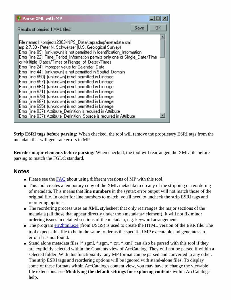
Strip ESRI tags before parsing: When checked, the tool will remove the proprietary ESRI tags from the metadata that will generate errors in MP.
Reorder major elements before parsing: When checked, the tool will rearranged the XML file before parsing to match the FGDC standard.
Notes● Please see the FAQ about using different versions of MP with this tool.● This tool creates a temporary copy of the XML metadata to do any of the stripping or reordering
of metadata. This means that line numbers in the syntax error output will not match those of the original file. In order for line numbers to match, you'll need to uncheck the strip ESRI tags and reordering options.
● The reordering process uses an XML stylesheet that only rearranges the major sections of the metadata (all those that appear directly under the <metadata> element). It will not fix minor ordering issues in detailed sections of the metadata, e.g. keyword arrangement.
● The program err2html.exe (from USGS) is used to create the HTML version of the ERR file. The tool expects this file to be in the same folder as the specified MP executable and generates an error if it's not found.
● Stand alone metadata files (*.sgml, *.sgm, *.txt, *.xml) can also be parsed with this tool if they are explicitly selected within the Contents view of ArcCatalog. They will not be parsed if within a selected folder. With this functionality, any MP format can be parsed and converted to any other. The strip ESRI tags and reordering options will be ignored with stand-alone files. To display some of these formats within ArcCatalog's content view, you may have to change the viewable file extensions. see Modifying the default settings for exploring contents within ArcCatalog's help.

See also● NBII metadata in ArcCatalog● Geodatabase file name conventions

Metadata template toolFunction: Create XML metadata template.
Tool icon: To enable: Select one dataset with metadata to use a source for template.
Creates a template metadata file in XML from the selected dataset using particular pieces of the metadata chosen by the user. This template can then be used for undocumented datasets using the Import metadata tool or Update with XML template tool. Clicking on the tool opens the following window:
The tool will export only those sections of the metadata that are checked in this window. Upon clicking OK, another window will ask the user for the name and folder of the newly created template.
Spell check metadata toolFunction: Spell check currently selected metadata file using Microsoft Word's spell checker.
Tool icon: To enable: Always enabled.
This tool converts all elements that are not automatically synchronized by ArcCatalog into a temporary file that is opened within Word for spell checking. Once the document is created, Word is automatically opened and the spell checking process started. After making any necessary spelling corrections, the changes will be incorporated back into the original metadata file.
Be careful when using this tool. Many table names and other metadata text will show up as spelling errors that shouldn't be changed.
Notes:
● This tool requires a Microsoft Word 2000 or XP to work correctly.● Code for this tool is almost completely based on the ESRI sample Metadata Spellchecker.

Find and Replace toolFunction: Batch find and replace text within metadata files.
Tool icon: To enable: Select one or more datasets or a folder to scan.
This tool searches across selected datasets (including subfolders) for the specified find text and replaces this text with the specified replace text. By default, all occurrences of the find string will be replaced. Beware of using strings, e.g. "and", that could be part of another unintended word or text string, e.g. "banded".
Clicking on the tool opens the following window:
In the Find box, type in the text string to search for in metadata.
In the Replace box, type in the text string to replace the find string with.
Click the Replace button to execute the replace.

Manually edit XML toolFunction: Manually edit XML metadata in text editor.
Tool icon: To enable: Select an object in tree or content view that contains metadata.
This tool allows you to manually edit the XML in a simple text editor. This functionality is particularly useful for geodatabase metadata records that are not accessible through the file system. Clicking the tool will prompt the user with a warning message before opening the text editor below:
Here, text can be added or deleted and standard cut-and-paste shortcuts can be used. Click Save to save the

changes back to the original metadata record for the selected object or Cancel to close without saving changes.
Warning: This tool gives you complete control over the XML metadata of an object and, therefore, has the potential to drastically corrupt the metadata record. Only use this tool if you thoroughly understand the structure of FGDC XML metadata and how to make changes to this XML
See also● Metadata formats

Delete metadata toolFunction: Batch delete metadata files.
Tool icon: To enable: Select one or more datasets.
Deletes metadata for the selected datasets and objects by physically deleting existing metadata from the file system (the associated *.xml file) or from a personal geodatabase metadata table entry (from the GDB_UserMetadata table). This tool will not recurse selected folders or geodatabases--it will only operate on the selected datasets or objects. Nor will it delete stand-alone *.xml metadata files.
Note: This tool is irreversible. Deleted files are not placed within the Recycle Bin. Please use tool with caution.

Metadata catalog toolFunction: Creates catalog of summary metadata in Access database.
Tool icon: To enable: Select a folder to scan.
Creates an Access 2000/XP database of all datasets in selected files or folders. Includes basic fields including file name, location, and a few metadata elements. Useful for finding missing or incomplete metadata in large data libraries.
To use the tool, select a folder to scan for datasets. Subfolders of this folder will also automatically be scanned. If a previous Access database has been created, a message box will appear asking if you'd like to use the same database. This option is useful if appending scans from multiple folders or for updating records for the specified folder. If no previous databases were created or you've chosen not to use it, a file save window will open asking for the location and file name of the Access database to create. Once a database is chosen, the tool will scan the selected folder creating records for each dataset that it encounters. Note that for large folder trees, this process can take several minutes. Once finished, the tool will ask if you'd like to open the created database within Access.
Note: some fields (e.g. abstract, purpose) are truncated to 255 characters within this database. Two larger fields, abstract and purpose, are stored as Access MEMO fields and include up to 65k characters.

Metadata searchFunction: Search metadata fields for specific strings.
Tool icon: To enable: Select a folder to search for datasets match search strings.
Tool to search metadata elements for specific text strings. This tool is intended to be a much easier way to search metadata than the existing ArcCatalog search functions. Clicking on the tool brings up the following window.
The Folder specifies which folders and subfolders will be searched for the specified string(s). It defaults to the currently selected folder and can be changed by either typing a new folder or clicking on the Browse… button.
In the Look for boxes, type in at least one text string to search metadata for and the element in which to search in the accompanying drop-down box. In the example above, the folder "C:\Data\Yellowstone" will be scanned for metadata which matches the two search criteria: the file name containing "soils" and the string "Lamar Valley" appearing anywhere else within the metadata.
Click on Search to initiate the scan. The search criteria window will disappear and the search results will gradually appear (scanning a large folder tree or network folder may take some time) in ArcCatalog's Contents window and be stored under the Search Results folder of ArcCatalog's left pane. Initiating a new search will replace these search results.
See also● ArcCatalog's Help: Searching with keywords
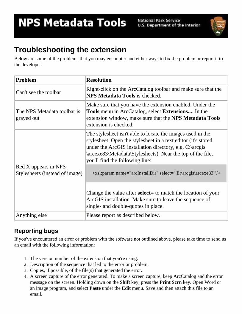
Troubleshooting the extensionBelow are some of the problems that you may encounter and either ways to fix the problem or report it to the developer.
Problem Resolution
Can't see the toolbarRight-click on the ArcCatalog toolbar and make sure that the NPS Metadata Tools is checked.
The NPS Metadata toolbar is grayed out
Make sure that you have the extension enabled. Under the Tools menu in ArcCatalog, select Extensions.... In the extension window, make sure that the NPS Metadata Tools extension is checked.
Red X appears in NPS Stylesheets (instead of image)
The stylesheet isn't able to locate the images used in the stylesheet. Open the stylesheet in a text editor (it's stored under the ArcGIS installation directory, e.g. C:\arcgis\arcexe83\Metadata\Stylesheets). Near the top of the file, you'll find the following line:
<xsl:param name="arcInstallDir" select="'E:\arcgis\arcexe83'"/>
Change the value after select= to match the location of your ArcGIS installation. Make sure to leave the sequence of single- and double-quotes in place.
Anything else Please report as described below.
Reporting bugsIf you've encountered an error or problem with the software not outlined above, please take time to send us an email with the following information:
1. The version number of the extension that you're using.2. Description of the sequence that led to the error or problem.3. Copies, if possible, of the file(s) that generated the error.4. A screen capture of the error generated. To make a screen capture, keep ArcCatalog and the error
message on the screen. Holding down on the Shift key, press the Print Scrn key. Open Word or an image program, and select Paste under the Edit menu. Save and then attach this file to an email.

5. Restart ArcCatalog before trying to do anything else.
Additionally, you can capture the debug messages that lead to this error. First, open the extension's debugging window by displaying the splash screen (by clicking on the NPS logo) and pressing "Ctrl-d" with the splash screen open. Second, redo the sequence of events that led to the bug. Last, save and send the output (if not locked up) from the debug window. Note that this procedure does not work in ArcGIS 9.x.
Send to
Eric CompasMidwest Regional GIS OfficeNational Park ServiceUniversity of Wisconsin-MadisonMadison, [email protected]