Embed Size (px)
Citation preview

NRC Convair-580 Atmospheric Remote Sensing Capabilities and Recent Research Activities
Acknowledgments: EC/NRC flight crew, S. Cober, students (Short, Fievet, Frebrowski & Shen) and various funding agencies.
Mengistu Wolde and Dave Marcotte
Contributions:
A. Pazmany (ProSensing Inc.), S. Haimov (Uwyo), G.A. Isaac, W. Strapp, D. Hudak, and A. Korolev (EC), J. Vivekanandan (NCAR)
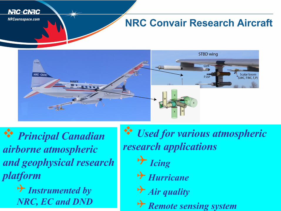
NRC Convair Research Aircraft
Principal Canadian airborne atmospheric and geophysical research platform
Instrumented by NRC, EC and DND
Used for various atmospheric research applications
Icing Hurricane Air quality Remote sensing system

Cloud Radar/Radiometer on NRC Convair 580
1999 – EC Ka-band (35 GHz) radar (EC: W. Stapp et al., FRL: J. Jordan & D. Marcotte) First Alliance Icing Research Study - (AIRS I) Hurricane Extra tropical Transition (ET) Study – Oct 2000
2003 – Porlarimetric W-band (95 GHz) NIF – AIRS II Nadir and Side-view (dual-pol) One time installation of University of Wyoming Cloud Radar
2006 –NRC MIC Funding + CSA NRC Airborne W and X-band (NAWX) Polarimetric radar system
ProSensing Inc. 183 GHz G-band Water Vapor Radiometer (GVR)

AIRSII Project
Conducted b/N Nov 2003 -Feb 2004 over Quebec and Ontario, Canada Collaborative international icing study with both ground and airborne component. The research focus include:
Better characterization of icing environment Remote detection of icing and validation Better understanding of icing process and its effect on aircraft
•

Remote sensing instruments
University of Wyoming Cloud Radar (WCR)
NRC Convair 580 – AIRS II instrumentation
Arrays of cloud physics probes PMS King LWC Rosemount icing detector PMS FSSP (5 – 95 µm) PMS 2DC Temperature

Moderate icing case over Mirabel Repeated horizontal transects at
various altitude Icing encounter from just above
the melting layer to 4.5 km (T~ -10°C)
Up to 0.8 g m-3 LWC
Radar signatures of Melting xls, mixed phase and icing clouds
Cloud Z structure In-situ and radar
data
Nov 19, 2003 – Flt #5: Moderate Icing

Melting layer: Z ~15-20 dBZ, LDR ~ -15 to -10 dB, ZDR~ 0-3 dB
Mixed phase: Z ~ 5-10 dBZ, LDR ~ -30 to -20 dB, ZDR ~ 0-1 dB
Rain: LDR ~ < -30 dB, ZDR ~ 0 dB
T ~ -3 to 0°CWCR: dual-pol.
Nov 19, 2003 – Melting Layer to Mixed Phase

T ~ -5°CWCR: dual-antenna
Nov 19, 2003 – Cloud Top – Mixed Phase
High Z change near cloud top (-30 to 10 dBZ), ML at 3 km Weak Z: calculated Z match the WCR Z at 75 m range High Z cores: mixed phase / ice

Combining in-situ and radar data
Develop radar and in-situ cloud physics data statistical analysis tool that has flexibility to use different
Radar variables Image classification schemes Atmospheric conditions Radar beam angle …. Remove noise and clutter from the radar data
Radar data
Time interval
Radar Range
Particle classification data (A, B, C, ..)
In-situ data range (T, LWC …)

Fuzzy-logic based particle classification
Radar signatures of particles – coincident radar and insitu measurements
Determine particle membership functions

Nov 11: Particle type: Radar / In-situ

Nov 19: Particle type: Radar / In-situ

Nov 24: Particle type: Radar / In-situ

Particle Types Identification
Good agreement between fuzzy-logic particle type classification result including icing from radar with in-situ cloud microphysics data
http://www.nawx.nrc.gc.ca
Issues/Future work: Identification of mixed phase clouds – plan to add other radar variables: Doppler velocity field, Dual-frequency option, more polarimetric variables Image classification from in-situ measurements

NRC Airborne W and X-bands radar (NAWX)
NAWX W-band X-band Transmitted Frequency (GHz) 94.05 9.41 Peak Tx Power (KW) 1.7 - typical 25 (split b/n two ports) Polarization Co and Cross Simultaneous H and V Doppler Pulse Pair and FFT Pulse Pair and FFT
Pulse Duration (µs) 0.1 - 10 0.11-1
Max PRF (KHz) 20 5 Ant. 3 dB BW (°) 0.75 3.5 Antenna ports 5 4 View direction Up, down and side Up, down and side
More details/updates: http://www.nawx.nrc.gc.ca

NAWX / CloudSat18-Feb-2007
Feb 182007: Boundary layer Cu Clouds
A/C at ~ 6 km at the time of the CloudSat pass
Good agreement of cloud top boundaries by WCR and NAWX
Difference b/n CPR and NAWX near the surface
NAWX on CPR
CPR on NAWX

NAWX / CloudSat25 – Feb-2007
NAWX – W Nadir
NAWX – W Side
Mixed phase midlevel cloud – A/C flying just below cloud top The images (top three right) show cloud vertical profiles obtained by CPR and the two NAWX radars.
Horizontal Z from NAWX

NAWX – 01-Mar- 2007
Flight in winter storm

NAWX – 01-Mar- 2007
X and W Ze from small (<800 µm) irregular ice crystals
Vertical profile of X and W Ze – note the reduction in W Ze – attenuation + mie effect

G-band (183 GHz) water Vapor Radiometer (GVR)
during C3VP
P r oSensingSyst ems Engineer ing f or Envir onment al Remot e Sensing
Developed by ProSensing Inc. and installed on the NRC Convair in a wingtip pod - looking in Zenith direction
Measures brightness temperature at 183.31 ±1, ±3, ±7 and ± 14 GHz
Operated in C3VP, STAR and ISDAC Projects
P r oSensingSyst ems Engineer ing f or Envir onment al Remot e Sensing

GVR/NAWX – 26-Jan-2007
Multiple layers Upper layer: All ice and shallow layer of supercooled drops at the top of the lower layer at T of ~ 10C° Convair made repeated porpoise maneuver in the liquid layer Good correlation between GVR and insitu LWC measurement
Preliminary work on retrievals of reff and N form combined GVR and NAWX data show good agreement with insitu data (Pazmany, Wolde and Hudak – 33rd AMS radar conference, Cairns, Australia, 2007) P r oSensing
Syst ems Engineer ing f or Envir onment al Remot e Sensing

GVR/NAWX – 26-Jan-2007
Multiple layers Upper layer: All ice and shallow layer of supercooled drops at the top of the lower layer at T of ~ 10C° Convair made repeated porpoise maneuver in the liquid layer Good correlation between GVR and insitu LWC measurement
Preliminary work on retrievals of reff and N form combined GVR and NAWX data show good agreement with insitu data (Wolde et. al. ICCP08)
P r oSensingSyst ems Engineer ing f or Envir onment al Remot e Sensing


![[XLS] · Web view580 580 580 580 580 580 580 580 580 580 580 580 580 580 580 580 580 580 580 580 580 580 580 580 580 580 580 580 580 580 580 580 580 580 580 580 580 580 580 580 580](https://img.pdfslide.net/doc/110x75/5ba1448d09d3f2666b8bff1c/xls-web-view580-580-580-580-580-580-580-580-580-580-580-580-580-580-580-580.jpg)