Embed Size (px)
DESCRIPTION
Framework Travel Plan for the North Sprowston and Old CAtton Outline Planning Application
Citation preview
10. FRAMEWORK TRAVEL PLAN NORTH SPROWSTON AND OLD CATTON
OUTLINE PLANNING APPLICATION
OCTOBER 2012
1. INTRODUCTION This Framework Travel Plan (FTP), prepared by SKM Colin Buchanan (SKM CB) for Beyond Green, accompanies the Outline Planning Application for North Sprowston and Old Catton, a sustainable urban extension on land within Broadland District, north of Norwich. As required by Norwich County Council travel plan guidance, as NS&OC will comprise multiple occupants across the site, an over-arching framework travel plan is required at this stage to set out the aims, targets and measures of the travel plan on a site-wide basis. Full travel plans will then need to be developed once the occupiers are known. As Beyond Green Developments will manage the residential element of the development, more detail is provided at this stage for the residential travel plan. The framework travel plan covers the following land uses:
• Residential • Commercial • Education (primary school) • Retail • Hotel • Community uses
It is difficult to quantify the exact number of people that will be covered by the travel plan at this stage but numbers will be in line with 3,520 residential dwellings, commercial and retail units and two primary schools.
The FTP details the measures that will be implemented to ensure that everyone who travels to and from NS&OC is encouraged to use the most sustainable travel modes appropriate to their travel needs. The measures introduced will provide the information, facilities and encouragement needed to enable those travelling to the site to make an informed and responsible decision about their travel behaviour, forming sustainable travel habits from the outset. The ethos of the development is to ensure sustainable modes of travel are the easiest and most convenient way to travel resulting in a situation where choosing a sustainable mode instead of a private car is second nature, rather than a conscious effort.
Although travel plans promote the use of sustainable and active travel modes, it is noted that in this location there will be some reliance on the private car; the aim will be for this reliance to be reduced where possible, especially single occupancy vehicle travel.
1.1 Reasons for a Travel Plan
Encouraging and enabling all users of the site to form sustainable travel habits from the outset will be key to limiting the impact of NS&OC on the environment and local highways. Therefore this framework travel plan will set out the intended package of innovative and targeted sustainable travel measures to promote non-car modes of travel, particularly walking and cycling, as well as more responsible car use, including car sharing and the use of car club vehicles. This process will begin before the first occupants move into the development and continue as an evolving process over time throughout the life of the development.
In addition to the travel plan for NS&OC, Beyond Green will be extending the travel plan initiatives through an area-wide travel plan (AWTP) that extends to the surrounding existing residential areas in order to stimulate travel behaviour change across a wider area. The aim is to offset the increase in car trips that will arise, whilst sharing the benefits of the new infrastructure with the existing communities. More information on the AWTP is provided in Section 10 of this report.
SKM (incorporating SKM Colin Buchanan) has a proven track record of implementing successful travel plans and personalised travel planning projects. The AWTP will involve a personalised travel planning methodology developed by SKM, which is founded upon a community-based social marketing approach to
1
initiate voluntary behaviour change, helping people to help themselves overcome their identified travel issues and make a positive change. Coupled with Beyond Green’s commitment to sustainable design and management, SKM CB are confident that the travel plan will achieve the ambitious targets set for mode shift away from the private car.
1.2 Policy and guidance
This travel plan is written to help achieve local and national policy aims and in accordance with local and national policy travel plan guidance, including the following:
• National Planning Policy Framework (NPPF) • Norwich Local Plan • Joint Core Strategy (JCS) for Broadland, Norwich and South Norfolk • Northern City Centre Area Action Plan (NCCAAP) • Norwich Area Transport Strategy (NATS) • Norfolk County Council Local Transport Plan (LTP) • DfT Good Practice Guidelines: Delivering Travel Plans through the Planning Process • Norfolk County Council’s online Travel Plan Guidance
A review of how the NS&OC the requirements of the planning policy is provided in the Transport Assessment.
2
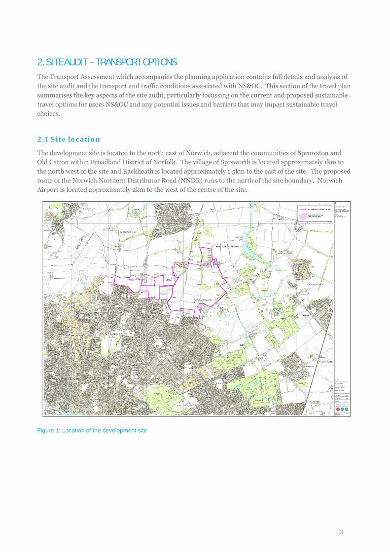
2. SITE AUDIT – TRANSPORT OPTIONS The Transport Assessment which accompanies the planning application contains full details and analysis of the site audit and the transport and traffic conditions associated with NS&OC. This section of the travel plan summarises the key aspects of the site audit, particularly focussing on the current and proposed sustainable travel options for users NS&OC and any potential issues and barriers that may impact sustainable travel choices.
2.1 Site location
The development site is located to the north east of Norwich, adjacent the communities of Sprowston and Old Catton within Broadland District of Norfolk. The village of Spixworth is located approximately 1km to the north west of the site and Rackheath is located approximately 1.5km to the east of the site. The proposed route of the Norwich Northern Distributor Road (NNDR) runs to the north of the site boundary. Norwich Airport is located approximately 2km to the west of the centre of the site.
Figure 1: Location of the development site
3
2.2 Walking and cycling
2.2.1 Cycling Facilities Cycling levels in Norwich are above average for comparable UK cities, helped by the low, flat topography and also the cycle routes and facilities available for cyclists, in which Norwich City Council have provided significant investment over the past few years.
The Norwich Cycle Map shows the signed Pedalways across the city and also identifies Spixworth Road and Church Lane as a Neighbourhood Routes. To the south of the site, White Woman Lane and Lodge Lane form part of the Outer Circuit that forms a loop around the outskirts of the city, linking to the local Cross City Pedalways (Cringleford – Sprowston and Lakenham – the Airport) that provide signed routes into the city centre. These routes also connect to the Inner Circuit that leads to Norwich rail station and to the Bowthorpe – Broadland Business Park Pedalway for staff commuting to work there.
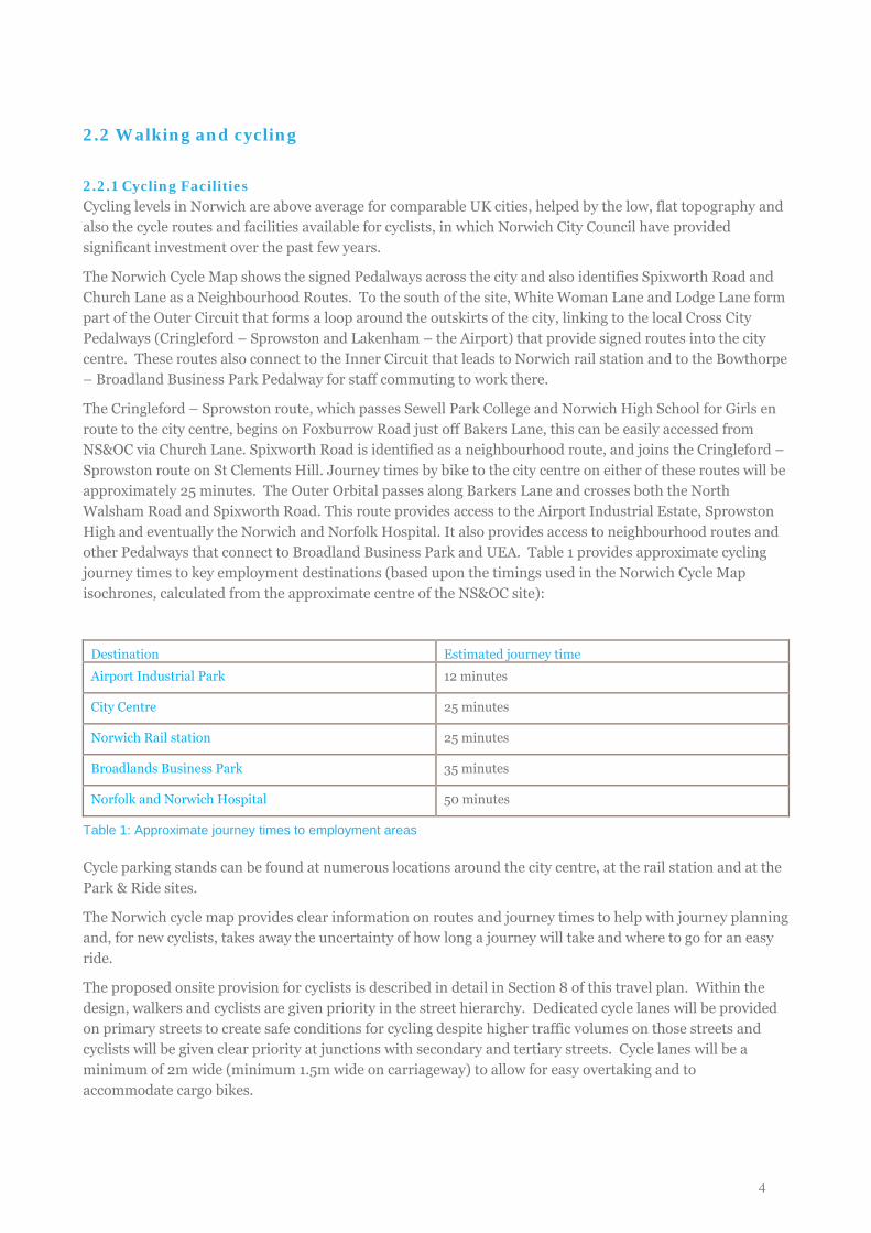
The Cringleford – Sprowston route, which passes Sewell Park College and Norwich High School for Girls en route to the city centre, begins on Foxburrow Road just off Bakers Lane, this can be easily accessed from NS&OC via Church Lane. Spixworth Road is identified as a neighbourhood route, and joins the Cringleford – Sprowston route on St Clements Hill. Journey times by bike to the city centre on either of these routes will be approximately 25 minutes. The Outer Orbital passes along Barkers Lane and crosses both the North Walsham Road and Spixworth Road. This route provides access to the Airport Industrial Estate, Sprowston High and eventually the Norwich and Norfolk Hospital. It also provides access to neighbourhood routes and other Pedalways that connect to Broadland Business Park and UEA. Table 1 provides approximate cycling journey times to key employment destinations (based upon the timings used in the Norwich Cycle Map isochrones, calculated from the approximate centre of the NS&OC site):
Destination Estimated journey time
Airport Industrial Park 12 minutes
City Centre 25 minutes
Norwich Rail station 25 minutes
Broadlands Business Park 35 minutes
Norfolk and Norwich Hospital 50 minutes
Table 1: Approximate journey times to employment areas
Cycle parking stands can be found at numerous locations around the city centre, at the rail station and at the Park & Ride sites.
The Norwich cycle map provides clear information on routes and journey times to help with journey planning and, for new cyclists, takes away the uncertainty of how long a journey will take and where to go for an easy ride.
The proposed onsite provision for cyclists is described in detail in Section 8 of this travel plan. Within the design, walkers and cyclists are given priority in the street hierarchy. Dedicated cycle lanes will be provided on primary streets to create safe conditions for cycling despite higher traffic volumes on those streets and cyclists will be given clear priority at junctions with secondary and tertiary streets. Cycle lanes will be a minimum of 2m wide (minimum 1.5m wide on carriageway) to allow for easy overtaking and to accommodate cargo bikes.
4
One-to-one cycle training in Norwich is provided by Smart Cycle Training (www.smartcycletraining.co.uk) at a cost of £15 for a one hour taster session, followed by £20 per hour for further sessions.
There are a number of established cycle shops across the city, and the Norwich City Council cycling website redirects users to the UEA BUG (Bicycle Users Group) site which provides a map of local cycle shops: http://www.uea.ac.uk/~r070/bikeshops.html
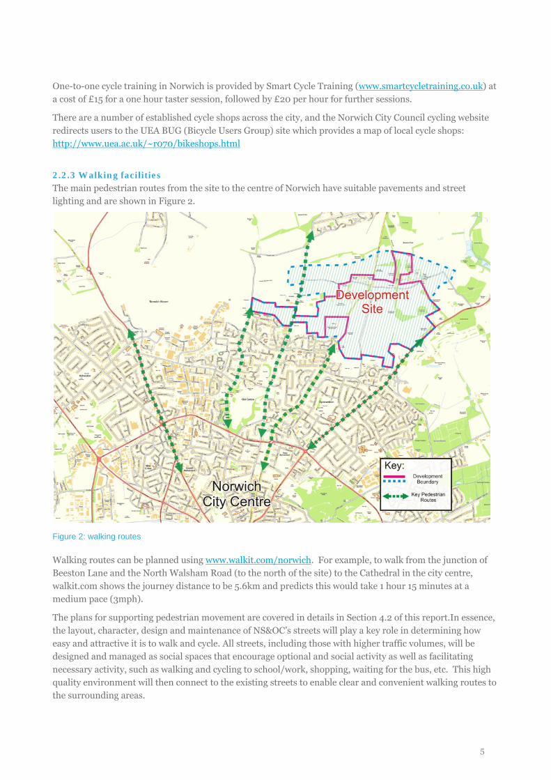
2.2.3 Walking facilities The main pedestrian routes from the site to the centre of Norwich have suitable pavements and street lighting and are shown in Figure 2.
Figure 2: walking routes
Walking routes can be planned using www.walkit.com/norwich. For example, to walk from the junction of Beeston Lane and the North Walsham Road (to the north of the site) to the Cathedral in the city centre, walkit.com shows the journey distance to be 5.6km and predicts this would take 1 hour 15 minutes at a medium pace (3mph).
The plans for supporting pedestrian movement are covered in details in Section 4.2 of this report.In essence, the layout, character, design and maintenance of NS&OC’s streets will play a key role in determining how easy and attractive it is to walk and cycle. All streets, including those with higher traffic volumes, will be designed and managed as social spaces that encourage optional and social activity as well as facilitating necessary activity, such as walking and cycling to school/work, shopping, waiting for the bus, etc. This high quality environment will then connect to the existing streets to enable clear and convenient walking routes to the surrounding areas.
5
2.3 Public transport
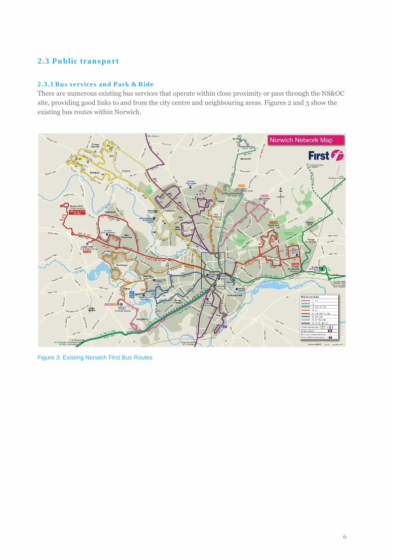
2.3.1 Bus services and Park & Ride There are numerous existing bus services that operate within close proximity or pass through the NS&OC site, providing good links to and from the city centre and neighbouring areas. Figures 2 and 3 show the existing bus routes within Norwich.
Figure 3: Existing Norwich First Bus Routes
6
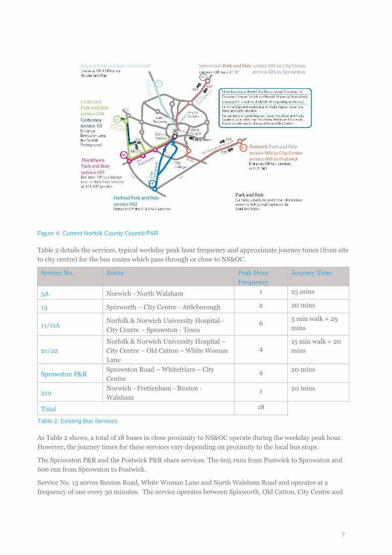
Figure 4: Current Norfolk County Council P&R
Table 2 details the services, typical weekday peak hour frequency and approximate journey times (from site to city centre) for the bus routes which pass through or close to NS&OC.
Service No. Route Peak Hour Frequency
Journey Time
5A Norwich - North Walsham 1 25 mins
13 Spixworth – City Centre - Attleborough 2 20 mins
11/11A Norfolk & Norwich University Hospital - City Centre – Sprowston - Tesco
6 5 min walk + 25 mins
21/22 Norfolk & Norwich University Hospital – City Centre – Old Catton – White Woman Lane
4 15 min walk + 20 mins
Sprowston P&R Sprowston Road – Whitefriars – City Centre
4 20 mins
210 Norwich - Frettenham - Buxton - Walsham
1 20 mins
Total 18
Table 2: Existing Bus Services
As Table 2 shows, a total of 18 buses in close proximity to NS&OC operate during the weekday peak hour. However, the journey times for these services vary depending on proximity to the local bus stops.
The Sprowston P&R and the Postwick P&R share services. The 605 runs from Postwick to Sprowston and 606 run from Sprowston to Postwick.
Service No. 13 serves Buxton Road, White Woman Lane and North Walsham Road and operates at a frequency of one every 30 minutes. The service operates between Spixworth, Old Catton, City Centre and
7
Mulbarton through the proposed development site using Buxton Road. This service is extended to Atteborough, south of Norwich.
Service No. 11/11A operates between the Sprowston Tesco, City Centre (via Wroxham Road), Eaton and Cringleford every 10 minutes during the day Monday to Saturday. During the evenings and on Sundays, the service operates every 30 minutes. Service 11A serves Cozens Hardy Road and Church Road. . This service is extended south of the city centre to provide a direct connection to the Norfolk and Norwich University Hospital via Cringleford.
Service No. 21/22 operates along White Woman Lane, Lodge Lane and St Faiths Road to Old Catton and the City Centre every 60 minutes Monday – Saturday during the evenings only. On Sundays, this service operates every 30 minutes throughout the day. This route will now provide a direct connection to Norfolk and Norwich University Hospital (21) and the University of East Anglia (22).
In terms of future bus infrastructure, the development proposals focus on building on the existing services, improving frequency and reliability for existing users as well as providing a convenient bus service for new residents and users of the new development. These enhanced services will complement those being introduced through NATS. More detailed information on plans for these services is provided in the Public Transport Statement and discussed in the measures section of this travel plan.
2.3.2 Rail services Norwich Rail Station is located approximately 500m east of the City Centre (6km from the development site) and offers frequent (half hourly) services to London Liverpool Street via Ipswich, Colchester and Chelmsford, and cross-country services to destinations such as Cambridge, Nottingham, Sheffield and Liverpool. Local services also operate to destinations along the Norfolk coast.
The location of the proposed development to the north-east of the city and the lack of direct bus services from this area to the station means that distance to the station will be a barrier for those residents wanting to commute by rail on a daily basis. However, this journey would be possible by bicycle (approximately 25 minutes) and there are 96 cycle parking stands located around the station, providing parking spaces for 192 bicycles. It is also only an 8 minute walk from the 10 & 10A bus stop at Castle Meadow to thw Station. The Public Transport Statement highlights opportunities for new bus services to provide a direct connection to the station.
2.4 Local highway network
Three principal routes extend through or adjacent to NS&OC in a general northeast/southwest direction, meeting with the Outer Ring Road (A1402) Chartwell Road:
• Wroxham Road (A1151) forms the eastern boundary of the site and along which the Park & Ride runs from the south eastern corner of the site;
• B1150 North Walsham Road passes through the centre of the site, leading into Constitution Hill before meeting the Outer Ring Road; and
• Buxton Road, which runs through the western side of the site, connecting to Spixworth Road in Old Catton.
In addition, St Faith’s Road borders the western side of the site, though it will provide no direct vehicular access to NS&OC. Beeston Lane operates in an east – west direction through the northern part of the site.
8

2.5 Car clubs and car sharing
Norfolk Car Club, operated by Commonwheels, currently offers 12 pay-as-you-go car club vehicles in Norwich. Beyond Green Developments have had early discussions with Norfolk Car Club to extend the network into the development site to provide this option for residents as an alternative to owning a private car, and in particular reducing the need for a second car.
Norfolk County Council operates an online car sharing facility at www.carsharenorfolk.com on which there are a number of private groups for large employers as well as the ability for members of the public to share journeys. Run by LiftShare, the website also contains a cost savings calculator and a comprehensive FAQs page.
9
3. CONSULTATION AND POTENTIAL BARRIERS TO SUSTAINABLE TRAVEL
3.1 Consultation
The ethos of NS&OC is one of sustainable living; every effort will be made to ensure that the infrastructure, facilities and culture of the development instil and nurture environmentally-friendly and active travel behaviour in all users of the site. In developing our proposals Beyond Green have consulted with a range of local stakeholders and the public to ensure that barriers to sustainable travel are addressed wherever possible through both design and travel plan initiatives.
Key organisations involved in ongoing consultation on the development design include:
• Broadland District Council; • Norfolk County Council; • Norwich City Council; • GNDP; • NNTAG; • Norwich Cycling Campaign; and • Sustrans.
In addition, in June 2011 Beyond Green held a Community Planning Workshop , to establish a series of key principles to inform the development of proposals for NS&OC and to further identify key opportunities and issues. One session specifically focussed on transport and the table overleaf provides a selection of the comments made on transport issues, alongside actions that are being taken forward to tackle these. Many of these are design issues, but have been included in the travel plan as they will affect the overall sustainable travel environment of the site and can be promoted through the travel plan measures.
The last row looks at the issue of traffic neutrality, i.e. reducing car use within existing urban areas in order to mitigate against the additional traffic that will result from the development. This is an ambitious aim for the development which is discussed more in Section 9 of this document which covers the area-wide travel plan proposals.
Quotes (by theme) Issues Actions
Walking and cycling
• “I’d love to bike but it’s too dangerous, we don’t have bikes coming into the city centre from the outskirts which I would like to see”
• “More cycle lane = less space for cars = a political issue”
• “Could you have wider areas with trees, space for cycleways and walkways? The road would be wide enough for emergency vehicles but not too wide”
• General recognition of need and benefits of increased walking and cycling, including reducing car on the school run
• Support for measures to increase cycling, including off-site infrastructure, but unclear whether there would be support for reallocation of road space etc.
• Wide roads and separate areas for pedestrians and cyclists can encourage higher speeds
• Prioritise walking and cycling on all on-site streets
• Explore potential to fund offsite improvements through CIL (where not included in NATS)
• Travel plan to include specific propositions for reducing school run traffic
• Develop street typologies that demonstrate walking and cycling priority for all streets in the hierarchy
Public transport
• “Need to ensure PT meets people’s
• Quality and reliability of services • Orbital journeys within and
beyond the Growth Triangle
• Establish relationship with bus operators
• Explore potential for
10
aspirations – clean, fast, cheap, reliable, goes where you want it to go – and people need to understand what is available”
• Political engagement for improving wider services – influence next generation of service provision e.g. changing the way buses are operated
• Accessibility of P&R for the development and opportunities for integration
• Route of BRT
integration with P&R and for P&R to serve early phases
• Explore potential for orbital connections and identify radial routes to be created, extended or improved
Reduce the need to travel
• “People need to be very content with the place that they live so that they don’t need to go off somewhere else on their day off”
• Recognition that mix of uses has a key role to play in reducing the need to travel
• Masterplanning incorporates a mix of uses.
• Economic and community strategies vital to establish both facilities and a sense of place
Parking
• “Make adequate provision for parking to ensure people don’t park in spaces you’d rather have for other uses”
• “I’d make a strong vote for charging for on street parking – potential revenue stream for management which could be available”
• “Restrictions in on-street parking is too crude a mechanism, but there is demand for housing without cars”
- No clear agreement from stakeholders on how to deal with parking and the role parking restraint should play as part of a sustainable movement strategy
- Establish a robust system for managed parking restraint
- Liaise with car club operators to establish maximum parking ratio for viability
Traffic neutrality
• “A community which is a new way of doing things hopefully won’t be dominated by car dependence – facilities such as car clubs should mean people don’t think they need to own a car”
• “Travel habits of people living on the urban fringe should be those of an inner urban area”
• “Recent developments have been too car dependent, so people only walk from house to car and don’t get to know their neighbours”
• General support for principle of traffic neutrality
• Concerns over achievability, particularly in the short-term. Realistically, to what extent can behaviour be influenced outside of the scheme?
• Will require partnerships to deliver off-site interventions, both hard and soft
• A difficult concept to “sell” to politicians and the public
• Continue to develop and test as an overall aim for the development and promote as an aim for the whole Growth Triangle
• Develop ideas for area wide travel planning and smarter choices interventions
Table 3: Transport issues raised at the Community Workshop (June 2011)
3.2 Barriers to sustainable travel
This travel plan aims to provide a comprehensive strategy for overcoming a range of real and perceived barriers to sustainable travel that may prevent various users of the site from choosing modes other than the
11
private car. These barriers, for which the travel plan measures in Section 8 will seek to overcome, may include:
• Habitual car use: o Separation of land uses and car orientated development o Convenience and personal value of private travel o Car as the default mode o Perceived inconvenience of other modes o Status issues and social norms
• Cycling: o Safety concerns, fear of cycling on busy roads, confidence issues o Nowhere to store a bicycle at home or at work/destination o Discomfort in doing something that is not the social norm o Lack of knowledge of best routes
• Walking: o Distance to shops, services and employment o Quality of walking environment and lack of pedestrian permeability
• Bus travel: o Frequency, journey time and reliability o Perceptions of discomfort and low status o Cost of public transport more visible than overall cost of car ownership
• Rail travel: o Distance between site and rail station o Lack of quick, direct bus to the station o High cost of season ticket and non pre-booked tickets
• Car sharing: o No knowledge of car sharing partners on same journey o Concerns about security and inconvenience o Lack of appreciation of potential financial savings
• Smarter working: o Need for high speed internet o Homeworking not supported by employer o Lack of space for home office
The mix of potential residents has also been taken into account when planning the measures and Appendix A contains a table setting out the solutions for the various needs of residents.
12
4. DEVELOPMENT PROPOSALS
4.1 Proposed development
The planning application for this development proposes to develop the site into a mixed use, residential-led mixed-use development comprising of:
• residential development of up to 3,520 dwellings (C3 use class); • up to 16,800m² (Gross Internal Area (GIA)) of commercial development (B1); • up to 8,800m² (GIA) of retail and service development (A1-A5); • up to 1,000m² (GIA) of hotel development (C1); • up to 5,000m² (NIA) of education development (D1); • up to 2,000m² (NIA) of other community development (D1); • an energy centre measuring up to 1,500m²; • 82.5 hectares of green space including up to 20.1ha of play and recreational space and at least 31.3ha of
new and retained natural and semi-natural space; and • four accesses to the highway network.
The outline planning application includes proposals for two primary schools within this site. However it is acknowledged that a secondary school is likely to be required in the Old Catton, Rackheath, Sprowston and Thorpe St Andrew growth triangle as it is developed. In case the secondary school is built within the development site at a future date, measures and targets for a secondary school are included in this framework travel plan.
4.2 Design principles and sustainable transport strategy
The wasterplan has been developed around the principles of sustainable urbanism. As such, sustainable movement is a fundamental concept of the design and the masterplan incorporates:
• Walkable neighbourhoods within which workplaces, shops and community facilities are integrated into the development alongside the housing provision, ensuring most residents can access their daily needs within walking distance and internalisation of travel to work trips is maximised;
• A compact, permeable layout with maximum connection between and along new and existing streets and other routes to create an environment in which pedestrians, cyclists and public transport are the preferred travel modes;
• High quality streets and public realm, in which people want to walk, linger and interact, with segregated cycle paths where necessary to provide cyclists with security and visibility.
• Streets with a maximum design speed of 20mph. • Full details on the sustainable transport infrastructure provision can be found in the Transport
Assessment but the key principles of the Sustainable Transport Strategy of the development are to: • Reduce the need to travel through effective land use planning; • Provide high quality, safe and direct routes for cyclists and pedestrians, ensuring walking and cycling have
priority and are visibly quick and convenient modes; • Integrate transport proposals with NATS; • Provide bus priority and enhance the existing bus service providing a service frequency of once every 15
minutes and frequent evening services; • Provide actively managed car parking; and • Provide alternative sustainable transport options such as: offering a car club, promoting lift sharing and
providing pool parking.
13
The travel plan measures will promote the available facilities to ensure all users have a high level of awareness of the new and existing infrastructure as well as that provided through NATS. By providing practical information on how to use sustainable modes and promoting their convenience of use, the travel plan will optimise use of these modes and reduce reliance on the private car.
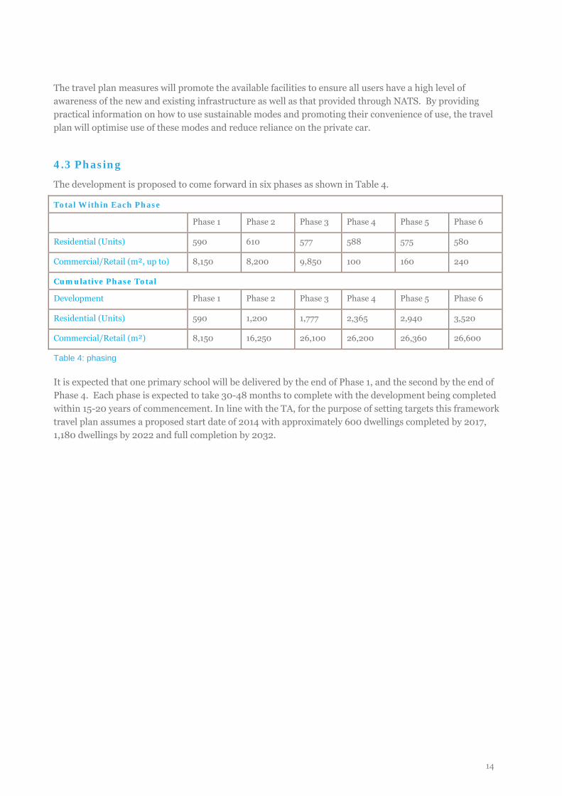
4.3 Phasing
The development is proposed to come forward in six phases as shown in Table 4.
Total Within Each Phase
Phase 1 Phase 2 Phase 3 Phase 4 Phase 5 Phase 6
Residential (Units) 590 610 577 588 575 580
Commercial/Retail (m², up to) 8,150 8,200 9,850 100 160 240
Cumulative Phase Total
Development Phase 1 Phase 2 Phase 3 Phase 4 Phase 5 Phase 6
Residential (Units) 590 1,200 1,777 2,365 2,940 3,520
Commercial/Retail (m²) 8,150 16,250 26,100 26,200 26,360 26,600
Table 4: phasing
It is expected that one primary school will be delivered by the end of Phase 1, and the second by the end of Phase 4. Each phase is expected to take 30-48 months to complete with the development being completed within 15-20 years of commencement. In line with the TA, for the purpose of setting targets this framework travel plan assumes a proposed start date of 2014 with approximately 600 dwellings completed by 2017, 1,180 dwellings by 2022 and full completion by 2032.
14
5. BASELINE TRAVEL PATTERNS
5.1 Introduction
As required by the Norfolk County Council guidelines, we 2001 Census data has been used to establish the mode share baseline for the development, establishing what could be expected in terms of travel to work mode share in this locality, for both residential trips (the development as the origin) and employment trips (the development at the destination).
Census mode share analysis is based on the ward of Sprowston Central which is in s a similar location in the north-eastern outskirts of the city with access to both North Walsham Road and Wroxham Road. The ward is located closer to the city centre reflecting aspirations for sustainable travel mode share expected in an urban rather than rural location.
Additional research on residential travel patterns was undertaken in March 2012, using a travel survey to assess the current travel habits at a comparable residential development at Lodge Farm in order to substantiate the findings of the Census data analysis. The survey was delivered to the approximate 355 homes that gain access by car from Lord Nelson Drive or Bawburgh Lane and a total of 90 survey forms were returned, giving a response rate of 25%. Full methodology and results of this travel survey are available on request. The results of this have been compared with the Census data in order to identify which best represents the proposed development. For the travel to the proposed schools we have used the most recently available data which is that reported in the 2009/10 school census.
The 2001 Census data is the most recent data available at present, with 2011 Census data due to be released next year. It is anticipated that at this time the travel plan targets will be re-evaluated in line with the more up-to-date data and adjusted if necessary.
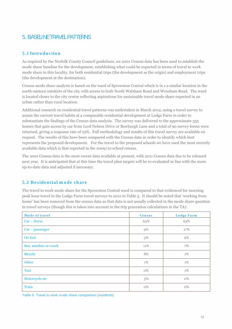
5.2 Residential mode share
The travel to work mode share for the Sprowston Central ward is compared to that evidenced for morning peak hour travel in the Lodge Farm travel surveys in 2012 in Table 5. It should be noted that ‘working from home’ has been removed from the census data as that data is not usually collected in the mode share question in travel surveys (though this is taken into account in the trip generation calculations in the TA):
Mode of travel Census Lodge Farm
Car – driver 63% 63%
Car – passenger 9% 17%
On foot 5% 9%
Bus, minibus or coach 11% 7%
Bicycle 8% 1%
Other 1% 1%
Taxi 0% 1%
Motorcycle etc 3% 0%
Train 0% 0%
Table 5: Travel to work mode share comparison (residents)
15
The results of both exercises provide a baseline mode share of 63% car driver and therefore this is adopted as the baseline mode share figure upon which to base the travel plan targets (see next section of this report).
Notable differences in the data include the much higher cycling mode share evidenced in the Census and higher levels of car sharing in the Lodge Farm survey. This may in part be due to the cold and wet conditions that were experienced when the survey was undertaken.
5.3 Workplace mode share
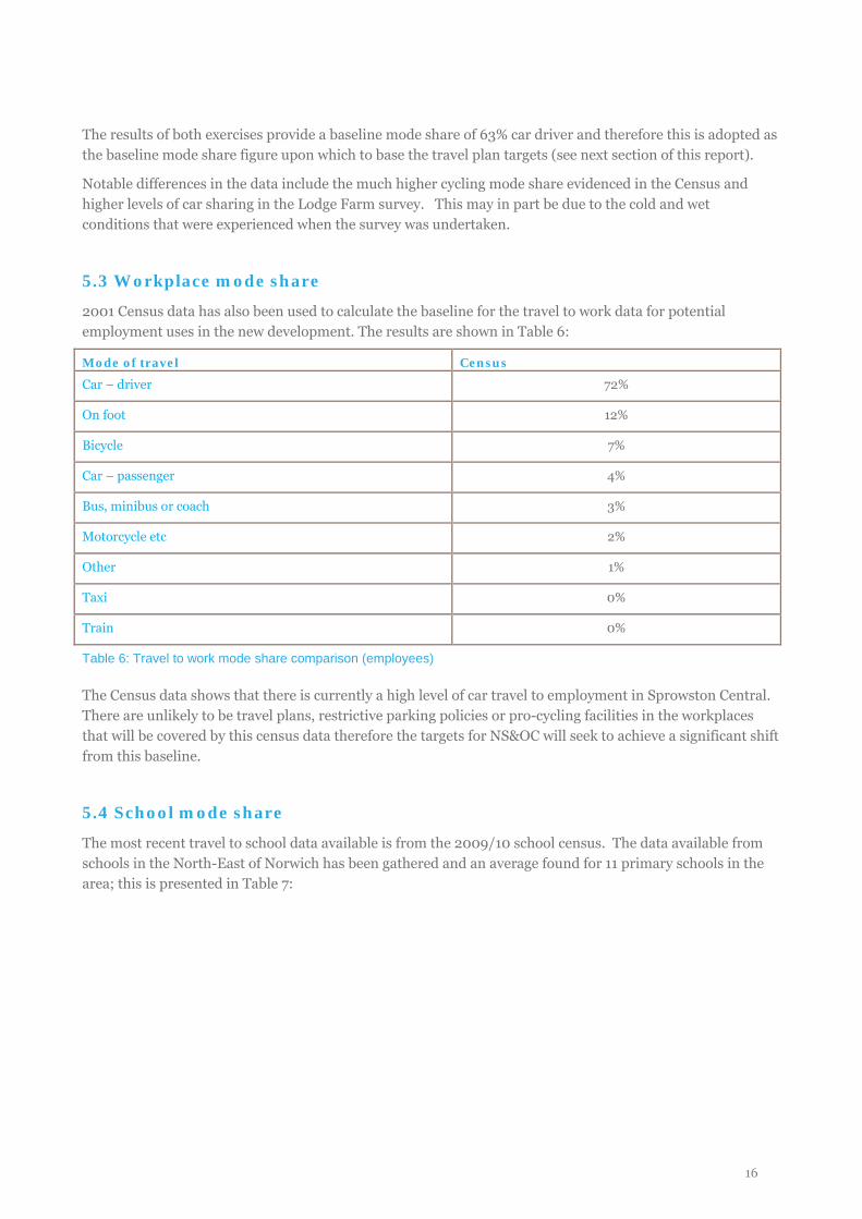
2001 Census data has also been used to calculate the baseline for the travel to work data for potential employment uses in the new development. The results are shown in Table 6:
Mode of travel Census
Car – driver 72%
On foot 12%
Bicycle 7%
Car – passenger 4%
Bus, minibus or coach 3%
Motorcycle etc 2%
Other 1%
Taxi 0%
Train 0%
Table 6: Travel to work mode share comparison (employees)
The Census data shows that there is currently a high level of car travel to employment in Sprowston Central. There are unlikely to be travel plans, restrictive parking policies or pro-cycling facilities in the workplaces that will be covered by this census data therefore the targets for NS&OC will seek to achieve a significant shift from this baseline.
5.4 School mode share
The most recent travel to school data available is from the 2009/10 school census. The data available from schools in the North-East of Norwich has been gathered and an average found for 11 primary schools in the area; this is presented in Table 7:
16
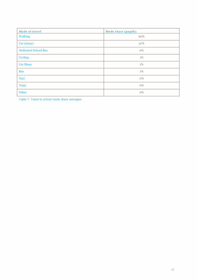
Mode of travel Mode share (pupils)
Walking 60%
Car (alone) 37%
Dedicated School Bus 0%
Cycling 1%
Car Share 1%
Bus 1%
Taxi 0%
Train 0%
Other 0%
Table 7: Travel to school mode share averages
17
6. OBJECTIVES, TARGETS AND MONITORING
6.1 Aim and objectives
The overarching aim of NS&)C is to to create an urban extension to Greater Norwich in which it is easy and attractive to live in environmentally sustainable ways while enjoying a high quality of life. The proposals include a permeable layout based on principles of walkable neighbourhoods; a mix of uses to reduce the need to travel; provision of convenient, attractive sustainable travel infrastructure; appropriate parking provision; and the implementation of a high-profile travel plan.
The objectives of the travel plan are as follows:
• to reduce the number and proportion of Single Occupancy Vehicle (SOV) trips from and to NS&OC from all land uses;
• to support the introduction of walking, cycling and bus infrastructure and help overcome the barriers to using sustainable modes of travel for all types of trips, including commuting, retail, leisure and education trips;
• to raise awareness of the financial, health and environmental (carbon emissions, , air quality and noise pollution) benefits of using alternative modes of travel to car;
• to incentivise habitual car drivers to try an alternative mode of travel and then to sustain this new travel behaviour;
• to promote the smarter choices initiatives available across Norwich and to enable and support effective partnership working between local authorities, community groups, schools and other stakeholders for mutual benefit; and
• to achieve traffic neutrality through the implementation of an area-wide travel plan in the existing neighbouring residential areas.
6.2 Targets
NS&OC is located on the suburban fringe of Norwich but through its design and management aims to have the sustainable travel patterns of an inner urban development. The site is designed to enable significant internalisation of trips, with a high proportion of the residents’ work, retail and leisure trips occurring within the boundaries of the site and therefore within walking or cycling distance.
In light of this, ambitious targets for mode shift are set which will be achieved through the implementation of a comprehensive and high profile travel plan, alongside the provision of infrastructure, restricted parking provision and a culture that supports sustainable and active travel behaviour. Targets will be monitored through travel surveys as discussed at the end of this section. The targets are SMART: Specific, Measurable, Achievable, Realistic and Time-bound.
It is acknowledged that the bus infrastructure will improve as the scheme is constructed and a critical mass for high frequency services is obtained. The result of this is that, despite offering personalised travel planning to encourage formation of sustainable travel habits from the outset, the uptake of public transport is unlikely to be as high in the early phases of development as it will be once the development is completed. The mode share targets reflect this situation and as such the first half of this chapter sets out the 5 year targets as required by the NCC travel plan guidelines and the second half of the chapter sets out long-term targets for the development to be achieved as the infrastructure develops fully.
18
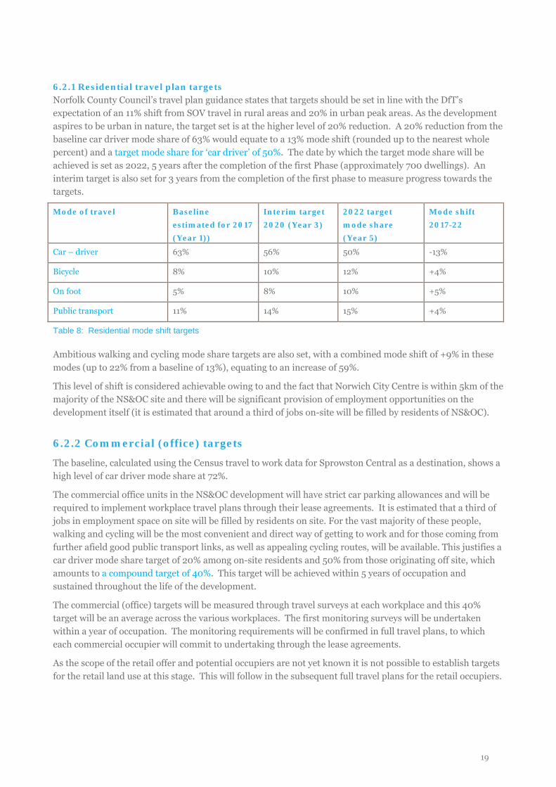
6.2.1 Residential travel plan targets Norfolk County Council’s travel plan guidance states that targets should be set in line with the DfT’s expectation of an 11% shift from SOV travel in rural areas and 20% in urban peak areas. As the development aspires to be urban in nature, the target set is at the higher level of 20% reduction. A 20% reduction from the baseline car driver mode share of 63% would equate to a 13% mode shift (rounded up to the nearest whole percent) and a target mode share for ‘car driver’ of 50%. The date by which the target mode share will be achieved is set as 2022, 5 years after the completion of the first Phase (approximately 700 dwellings). An interim target is also set for 3 years from the completion of the first phase to measure progress towards the targets.
Mode of travel Baseline estimated for 2017 (Year 1))
Interim target 2020 (Year 3)
2022 target mode share (Year 5)
Mode shift 2017-22
Car – driver 63% 56% 50% -13%
Bicycle 8% 10% 12% +4%
On foot 5% 8% 10% +5%
Public transport 11% 14% 15% +4%
Table 8: Residential mode shift targets
Ambitious walking and cycling mode share targets are also set, with a combined mode shift of +9% in these modes (up to 22% from a baseline of 13%), equating to an increase of 59%.
This level of shift is considered achievable owing to and the fact that Norwich City Centre is within 5km of the majority of the NS&OC site and there will be significant provision of employment opportunities on the development itself (it is estimated that around a third of jobs on-site will be filled by residents of NS&OC).
6.2.2 Commercial (office) targets
The baseline, calculated using the Census travel to work data for Sprowston Central as a destination, shows a high level of car driver mode share at 72%.
The commercial office units in the NS&OC development will have strict car parking allowances and will be required to implement workplace travel plans through their lease agreements. It is estimated that a third of jobs in employment space on site will be filled by residents on site. For the vast majority of these people, walking and cycling will be the most convenient and direct way of getting to work and for those coming from further afield good public transport links, as well as appealing cycling routes, will be available. This justifies a car driver mode share target of 20% among on-site residents and 50% from those originating off site, which amounts to a compound target of 40%. This target will be achieved within 5 years of occupation and sustained throughout the life of the development.
The commercial (office) targets will be measured through travel surveys at each workplace and this 40% target will be an average across the various workplaces. The first monitoring surveys will be undertaken within a year of occupation. The monitoring requirements will be confirmed in full travel plans, to which each commercial occupier will commit to undertaking through the lease agreements.
As the scope of the retail offer and potential occupiers are not yet known it is not possible to establish targets for the retail land use at this stage. This will follow in the subsequent full travel plans for the retail occupiers.
19
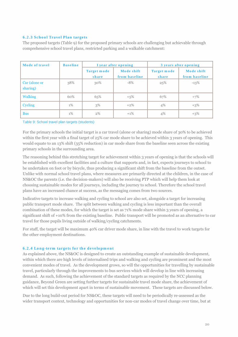
6.2.3 School Travel Plan targets The proposed targets (Table 9) for the proposed primary schools are challenging but achievable through comprehensive school travel plans, restricted parking and a walkable catchment:
Mode of travel Baseline 1 year after opening 3 years after opening
Target mode share
Mode shift from baseline
Target mode share
Mode shift from baseline
Car (alone or sharing)
38% 30% -8% 25% -13%
Walking 60% 65% +5% 67% +7%
Cycling 1% 3% +2% 4% +3%
Bus 1% 2% +1% 4% +3%
Table 9: School travel plan targets (students)
For the primary schools the initial target is a car travel (alone or sharing) mode share of 30% to be achieved within the first year with a final target of 25% car mode share to be achieved within 3 years of opening. This would equate to an 13% shift (35% reduction) in car mode share from the baseline seen across the existing primary schools in the surrounding area.
The reasoning behind this stretching target for achievement within 3 years of opening is that the schools will be established with excellent facilities and a culture that supports and, in fact, expects journeys to school to be undertaken on foot or by bicycle, thus producing a significant shift from the baseline from the outset. Unlike with normal school travel plans, where measures are primarily directed at the children, in the case of NS&OC the parents (i.e. the decision-makers) will also be receiving PTP which will help them look at choosing sustainable modes for all journeys, including the journey to school. Therefore the school travel plans have an increased chance at success, as the messaging comes from two sources.
Indicative targets to increase walking and cycling to school are also set, alongside a target for increasing public transport mode share. The split between walking and cycling is less important than the overall combination of these modes, for which the target is set as 71% mode share within 3 years of opening, a significant shift of +10% from the existing baseline. Public transport will be promoted as an alternative to car travel for those pupils living outside of walking/cycling catchments.
For staff, the target will be maximum 40% car driver mode share, in line with the travel to work targets for the other employment destinations.
6.2.4 Long-term targets for the development As explained above, the NS&OC is designed to create an outstanding example of sustainable development, within which there are high levels of internalised trips and walking and cycling are prominent and the most convenient modes of travel. As the development grows, so will the opportunities for travelling by sustainable travel, particularly through the improvements to bus services which will develop in line with increasing demand. As such, following the achievement of the standard targets as required by the NCC planning guidance, Beyond Green are setting further targets for sustainable travel mode share, the achievement of which will set this development apart in terms of sustainable movement. These targets are discussed below.
Due to the long build-out period for NS&OC, these targets will need to be periodically re-assessed as the wider transport context, technology and opportunities for non-car modes of travel change over time, but at
20
present these targets define the long term vision for the sustainable travel mode share. In order to succeed, the proposals for NS&OC will need to be supported by the NATS programme of transport improvements and smarter travel measures, so that the new residents and other users of the site have access to sustainable travel modes throughout the city and beyond, and so that initiatives at NS&OC and the wider area complement and enhance each other.
6.2.5 Residential targets The initial mode shift from the baseline as set out in Table 7 will be primarily achieved through the conversion of residents’ travel choices to sustainable travel modes and forming of sustainable travel habits upon moving into the development e.g. through the personalised travel advice offered on occupation, alongside the measures such as generous and visible cycle parking, cycle training and the car club which will be available from first occupation.
However, as discussed at the start of this chapter and set out on the Public Transport Statement, the full bus infrastructure will not be available for the first occupiers of the development. Instead, the infrastructure will be added in line with the increased population so that as the development matures, the public transport services will become more convenient and therefore more attractive. Therefore the potential for a higher sustainable travel mode share will increase as the time goes on. It is also expected that local conditions outside of the site will improve to help encourage a wider shift to sustainable modes, for example through the implementation of NATS and other initiatives by the local authorities.
With these factors in mind, a further target is then proposed for long-term continued mode shift to reach a higher sustainable travel mode share by completion of the development in 2032. This long-term target for 2032 is to achieve a 35% car driver mode share for residents’ journeys to work. This would equate to an additional 15% mode shift, or 30% reduction in car driver mode share, from the target mode share of 50% which is set to be achieved by 2022.
This target is significantly more stretching than the mode shift expected by the DfT (-20% for urban development, compared to -30% proposed for NS&OC from 2022-2032), demonstrating the commitment to making this a leading sustainable development
The propensity to encourage a high level of walking and cycling from the site, and therefore low car mode share, through provision of an environment, ethos and infrastructure to support walking/cycling for distances under 5km can be evidenced through looking at the distance travelled to work in the neighbouring areas.
In the areas of Sprowston and Old Catton that border NS&OC, the 2001 Census showed that around 23% of residents’ journeys to work are of less than 2km and 65% of less than 5km. A 2km journey would take approximately 25 minutes to walk or 8 minutes to cycle, and 5km can be cycled in approximately 20 minutes.
Assuming that new NS&OC residents show similar characteristics in terms of distance travelled to work (the slightly further distance from Norwich City Centre of the NS&OC development balanced by the improved facilities and increased local job opportunities on site), it is robust to conclude that the target of 65% travelling to work by walking, cycling or public transport can be achieved and sustained over time.
Meeting this target will rely on the external conditions also supporting walking, cycling and public transport, so will be dependent upon wider initiatives and infrastructure, such as those brought in through NATS. .
6.2.6 Travel to work targets (long-term) For the commercial (office) development, the target of a maximum of 40% car (alone) mode share is set to be achieved within the first 5 years of occupation and maintained throughout the life of the development. Any
21
further long-term targets will be reviewed through workplace travel plans delivered by each commercial occupier, coordinated by the site-wide Travel Plan Coordinator.
6.2.7 Travel to school targets (long-term) It is intended that the vast majority of journeys to school will be from the development itself and from local areas of North Sprowston and Old Catton, therefore within walking and cycling distance and so the aim of the school travel plans will be to maximise the walking and cycling mode shares.
Further targets will be set for the schools in their full school travel plans (which will be prepared by the school management teams) to recognise the increased opportunity for walking and cycling to school as the development matures. It is intended that a long-term target of 85% pupils’ journeys to school to be by walking/cycling/public transport could be achieved, but this will need to be reviewed and confirmed once the schools’ catchment is known.
Promoting a culture of walking and cycling and discouraging car use will be a key part of the school’s ethos and supported by senior management, but it will also require the support of the local authorities to help enforce parking regulations to make it unattractive to parents to drive to the school.
22
7. MEASURES AND CAMPAIGNS
7.1 Overview
The travel plan will be implemented as a package of measures, designed to work collectively to overcome the various barriers and encourage a switch to sustainable travel. The aim is for nudges and prompts to come from many sources, the combined effect of which will generate the required level of sustainable travel behaviour across the population, then sustain and improve on this over the long-term. Many of the measures will be implemented prior to and on occupation of the development, to ensure new residents and other users of the site establish sustainable travel habits from the outset.
The measures in this travel plan are guided by current best practice in travel behaviour change and social marketing methods. For example the four levers used in social marketing are all incorporated in the design of the development or the travel plan:
• Support: giving people means and solutions to adopt the desired behaviour e.g. convenient, secure cycle parking; trial-a-bike scheme; car club membership etc.
• Design: changing the environment, physical context and products to support the new behaviour e.g. bus service improvements; pedestrian and cyclist priority and permeability; services and employment within walking distance etc.
• Inform and educate: providing information to advise, build awareness, persuade and inspire e.g. travel information pack and PTP session offered to household on occupation; Bike Week campaigns; clear signage etc.
• Control: take steps to legislate, require, enforce and set standards e.g. parking management; requirement for travel plan commitment in lease agreements etc.
In particular, at this site we will be focussing on encouraging walking and cycling, taking advantage of the smarter travel initiatives that already exist in Broadland and Norwich (such as the cycling improvements and Norwich car club), and also on promoting bus use, through new and improved services.
In terms of infrastructure, bus improvements will build upon the existing services along the core corridors from the development to the city centre, namely Wroxham Road and Spixworth Road, with a new service developed along the North Walsham Road. New and enhanced bus services will be provided when development begins to be built outside of an existing service. The aim is to gradually improve core service frequency from one bus every 30 minutes (current) to one every 10 minutes. Full details of the bus service improvement proposals are provided in the Public Transport Statement, with a timeline of how service frequency will improve in line with development growth.
Rail will not be the primary focus of the travel plan due to the distance from the rail station, but it will be an option for some travel in conjunction with other sustainable modes (for example, business travel) and therefore rail travel will be encouraged for longer distance journeys, with information provided on both strategic and local routes as an alternative to driving.
7.2 Measures by land use
This framework travel plan outlines the measures proposed for the residential, commercial (workplace) and school travel plans. The subsequent full travel plans, produced when the occupiers are known) will provide more details on these measures and how they will be managed for that specific site. It should be noted that journeys to secondary schools will be covered by the residential travel planning measures, particularly PTP, even if there are no secondary schools on the site itself.
23
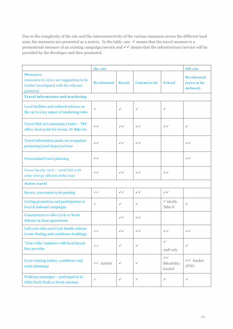
Due to the complexity of the site and the interconnectivity of the various measures across the different land uses, the measures are presented as a matrix. In the table, one means that the travel measure is a promotional measure of an existing campaign/service and means that the infrastructure/service will be provided by the developer and then promoted.
On-site Off-site
Measures (measures in italics are suggestions to be further investigated with the relevant partners)
Residential Retail Commercial School Residential (area to be defined)
Travel information and marketing
Local facilities and reduced reliance on the car is a key aspect of marketing/sales
Travel Hub in Community Centre – TPC office, focal point for events, Dr Bike etc.
Travel information packs on occupation promoting local shops/services
Personalised travel planning
Green loyalty card – could link with other energy efficient behaviour
Active travel
Secure, convenient cycle parking
Cycling promotion and participation in local & national campaigns
ideally
‘Bike It’
Commitment to offer Cycle to Work Scheme in lease agreements
Led cycle rides and Cycle Buddy scheme (route-finding and confidence-building)
‘Trial a bike’ initiative with local bicycle hire provider
staff only
Cycle training (safety, confidence and route planning)
funded
Bikeability funded
funded (PTP)
Walking campaigns – participation in NHS/DoH/Walk to Work schemes
24
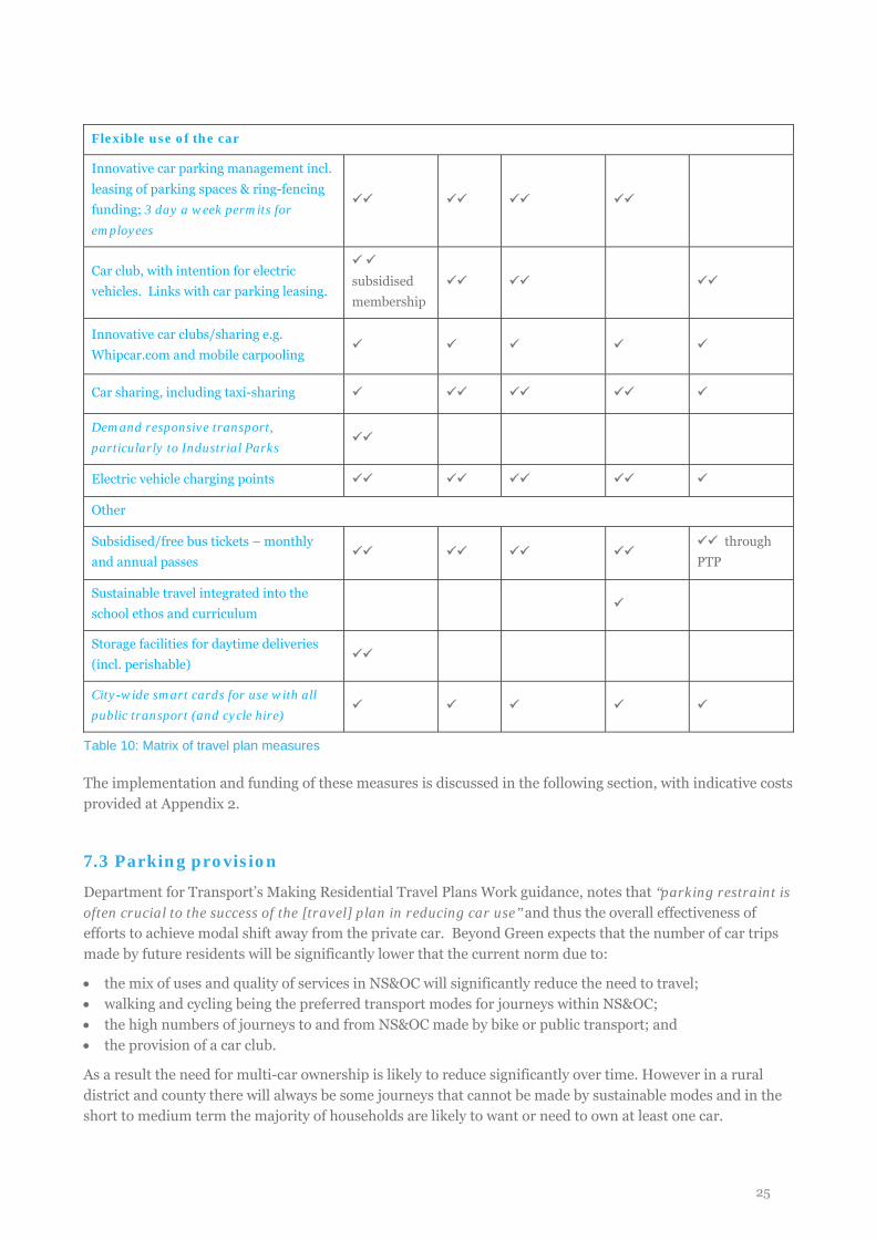
Flexible use of the car
Innovative car parking management incl. leasing of parking spaces & ring-fencing funding; 3 day a week permits for employees
Car club, with intention for electric vehicles. Links with car parking leasing.
subsidised membership
Innovative car clubs/sharing e.g. Whipcar.com and mobile carpooling
Car sharing, including taxi-sharing
Demand responsive transport, particularly to Industrial Parks
Electric vehicle charging points
Other
Subsidised/free bus tickets – monthly and annual passes
through
PTP
Sustainable travel integrated into the school ethos and curriculum
Storage facilities for daytime deliveries (incl. perishable)
City-wide smart cards for use with all public transport (and cycle hire)
Table 10: Matrix of travel plan measures
The implementation and funding of these measures is discussed in the following section, with indicative costs provided at Appendix 2.
7.3 Parking provision
Department for Transport’s Making Residential Travel Plans Work guidance, notes that “parking restraint is often crucial to the success of the [travel] plan in reducing car use” and thus the overall effectiveness of efforts to achieve modal shift away from the private car. Beyond Green expects that the number of car trips made by future residents will be significantly lower that the current norm due to:
• the mix of uses and quality of services in NS&OC will significantly reduce the need to travel; • walking and cycling being the preferred transport modes for journeys within NS&OC; • the high numbers of journeys to and from NS&OC made by bike or public transport; and • the provision of a car club.
As a result the need for multi-car ownership is likely to reduce significantly over time. However in a rural district and county there will always be some journeys that cannot be made by sustainable modes and in the short to medium term the majority of households are likely to want or need to own at least one car.
25
Broadland District Council’s Parking Standards SPD uses the current average levels of car ownership (1.6 cars per vehicle owning household) as the basis for the development of parking standards. The SPD sets out a range of parking standards based on dwelling size, but also notes that variations on these standards are permitted “where it can be demonstrated [that] proximity to facilities or particularly good public transport alternatives make normal levels of parking unnecessary.”
Reflecting this context and based on the mix of housing proposed the parking strategy at NS&OC is to provide an average of 1.5 parking spaces per dwelling (excluding visitor parking) and then establish a robust system for managed parking restraint in order to allow parking ratios to be reduced over time in accordance with sustainable travel objectives and outcomes. Central to this strategy is providing a substantial share of residential parking off-plot (i.e. on-street or in-courtyard) allowing occupation of property to be separated from ownership or tenancy of parking spaces, with off-plot parking managed on a permit-leasing basis by the development management company or the local authority. This approach:
• enables management regimes which incentivise modal shift over time, for example by requiring leases for off-plot parking to be renewed regularly thereby helping to make the total cost of car ownership more transparent and comparable with, for example, the need to renew public transport season tickets regularly;
• allows parking to be used flexibly, with unused residential spaces being transferred over time to flexible visitor or business use;
• allows for surplus parking to be ‘retired’ over time, for example with on-street parking within ‘flex zones’ being convertible to pedestrian, cyclist or green space;
• ensures that streets can be designed to accommodate on-street parking from the outset, avoiding informal parking that has caused pavement and carriageway obstructions in neighbouring developments; and
• supports the aim of the street hierarchy to limit the extent to which street frontage is disrupted by frontage access to driveways.
Design and Access Statement Appendix A, Table A7 shows the parking ratios proposed, and how these break down between housing types. These ratios will be regularly reviewed to ensure they reflect the parking take-up in each phase of development.
Applying Broadland’s parking standards, additional car parking is required for visitors (one space per four dwellings, amounting to 880 spaces), employment (3 spaces per 100m2, amounting to 504 spaces) retail (3 spaces per 200m2, amounting to 132 spaces) and community (1 space per 100m2, amounting to 20 spaces). There is sufficient capacity within the plan for these additional 1,456 spaces (and an additional 6% allowance for disabled provision) to be accommodated flexibly off-plot in designated on-street bays, although there will be further capacity within blocks and it is recognised that some uses (e.g. a small supermarket or a community centre) may require dedicated space. However, given the extent of off-plot residential provision and the very high likelihood that commuting inflows of workers will be outweighed by commuting outflows of residents it is proposed that the final quantum, length of stay and charges for visitor and commercial parking be established during detailed design. This quantum will be informed by Broadland District Council’s Parking Standards SPD, however the mix of uses at NS&OC mean that strict application of the SPD parking standards for individual uses is likely to result in an overprovision of parking, compromising efforts to encourage visitors as well as residents to travel by sustainable modes. It has been assumed that any car parking required on school sites will be accommodated within site boundaries.
Over 4,000 on-street parking spaces could be accommodated by applying the parking principles set out in the Street Hierarchy. This relates to a total residential parking requirement of 5,238 spaces and a maximum visitor, commercial and retail parking requirement of 1,543 (including disabled provision). There is significant capacity within blocks to accommodate the remaining parking requirements.
26
7.4 Cycle parking provision
Secure, covered, accessible and easy to use cycle parking will be provided for all dwellings, with each dwelling being provided with at least 1 space per bedroom up to 3 bedroom dwellings; then 3 spaces for 4 bedroom dwellings, 4 spaces for 5 bedroom dwellings, etc. The need for on plot or shared parking for cargo bikes and for additional shared ‘over spill’ cycle parking will be considered at detailed design; this could include secure cycle lockers within parking courts or flex parking zones. On street visitor cycle parking will be provided on all residential streets, usually accommodated within flex parking zones.
The location, type and quantum of visitor and commercial cycle will be established during detailed design. A variety of parking typologies will be provided including Sheffield stands (or similar) for short stay visitor parking, covered long stay visitor and employee parking and secure on plot parking within commercial buildings. All visitor and commercial cycle parking will be accessible, easy to use and over looked. Visitor and commercial cycle parking usage and capacity will be monitored and additional parking will be installed if demand exceeds provision.
The design specifications for cycle parking will in due course be set out in the Site Wide Design Code, and will reflect current best practice such as Cambridge City Council’s Cycle Parking Guide for New Residential Developments (2010).
27
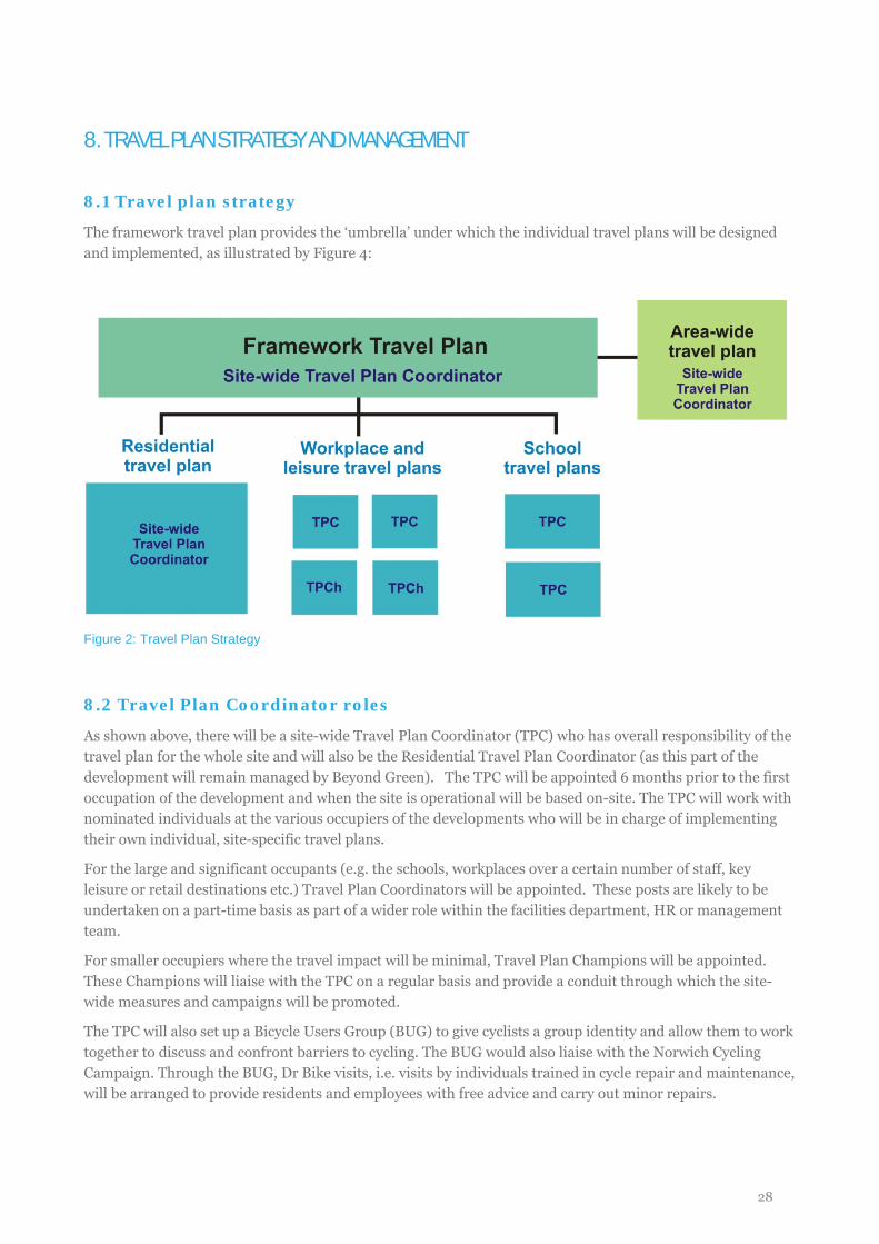
8. TRAVEL PLAN STRATEGY AND MANAGEMENT
8.1 Travel plan strategy
The framework travel plan provides the ‘umbrella’ under which the individual travel plans will be designed and implemented, as illustrated by Figure 4:
Figure 2: Travel Plan Strategy
8.2 Travel Plan Coordinator roles
As shown above, there will be a site-wide Travel Plan Coordinator (TPC) who has overall responsibility of the travel plan for the whole site and will also be the Residential Travel Plan Coordinator (as this part of the development will remain managed by Beyond Green). The TPC will be appointed 6 months prior to the first occupation of the development and when the site is operational will be based on-site. The TPC will work with nominated individuals at the various occupiers of the developments who will be in charge of implementing their own individual, site-specific travel plans.
For the large and significant occupants (e.g. the schools, workplaces over a certain number of staff, key leisure or retail destinations etc.) Travel Plan Coordinators will be appointed. These posts are likely to be undertaken on a part-time basis as part of a wider role within the facilities department, HR or management team.
For smaller occupiers where the travel impact will be minimal, Travel Plan Champions will be appointed. These Champions will liaise with the TPC on a regular basis and provide a conduit through which the site-wide measures and campaigns will be promoted.
The TPC will also set up a Bicycle Users Group (BUG) to give cyclists a group identity and allow them to work together to discuss and confront barriers to cycling. The BUG would also liaise with the Norwich Cycling Campaign. Through the BUG, Dr Bike visits, i.e. visits by individuals trained in cycle repair and maintenance, will be arranged to provide residents and employees with free advice and carry out minor repairs.
28
8.3 Timescales
Implementation of the travel will start prior to the first occupation of the development with the marketing suite presenting the key sustainable travel features as a key selling point of the development. The Travel Information Packs and website will also be ready prior to occupation so they can be distributed on occupation of each property.
8.4 Funding
The framework travel plan will be secured through a Section 106 agreement. Individual travel plans for the school and commercial occupiers will be required through the Section 106 and lease agreements will include a commitment to developing and implementing a travel plan.
The implementation of the travel plan, including the TPC post, will be funded by Beyond Green for the life of the development-related travel plan, as required by planning conditions. Some indicative cost estimates are provided at Appendix 2.
8.5 Marketing, promotion and travel information
The site-wide travel plan will be covered by an over-arching travel plan brand, which can also be adopted by subsequent travel plans implemented as new occupants become involved.
8.5.1 Information for marketing offices and show homes Marketing materials will provide details of how to access the site by sustainable modes and the Sales team will be fully briefed on the sustainable transport opportunities at the development. An information sheet will also be produced and displayed within the on-site marketing office and show homes to promote the travel plan including initiatives and its objectives. This can then be distributed to prospective home owners to further promote the concept of the travel plan and its aims prior to home occupation. In this way, the accessibility by cycling, walking and public transport, and the availability of a pay-as-you-go car will be promoted as a key selling point of the development.
8.5.2 Travel Information Packs A Travel Information Pack will be designed and distributed to all residents by the Travel Plan Coordinator. The packs will be distributed on occupation to have an immediate impact. The packs will include the following:
• map of the site highlighting the travel related facilities such as bus stops and cycle stands; • a wider map showing walking, cycling and public transport routes and journey times to key destinations
such as the city centre, Broadland Business Park, schools, leisure destinations etc. plus an indication of the number of calories burnt and carbon emissions saved for journeys by walking and cycling rather than the private car;
• the offer of a PTP visit from a Travel Advisor to help with journey planning and travel information; • links to relevant local websites with travel information, including the City, County and District Council
websites, www.transportdirect.info, www.walkit.com, and cycling organisations; • details of the benefits of car sharing and information on Car Share Norfolk; • Car Club information including details of promotions and memberships deals for residents (to be
negotiated); • information about the travel plan and its key objectives; • vouchers for cycle training sessions and information on locking your bike;
29
The feedback survey form will be enclosed in the travel information pack which can be submitted at any time to the Travel Plan Coordinator and also available online. The feedback from these forms will assist in gathering information about perceived transport choices and any ideas on ways to improve the travel plan. Results of this will be included in monitoring reports and steering group meetings.
Throughout the construction and occupation of the development the packs will be kept up to date by the Travel Plan Coordinator and revisions will contain the results of any monitoring, targets and achievements. It is important to provide details of achievements, as success will further add to the promotion of the travel plan, raising awareness and increasing the desire to achieve further goals. The packs will also be supported by the website, which will provide residents with information on new campaigns and information long after they move into the site.
Travel Information Packs will not be distributed in the same format to participants in the PTP programme (through the area-wide travel plan). Instead, information will be more targeted according to the issues and opportunities identified during the PTP conversation with the Travel Advisor.
8.5.3 Websites and social media Travel information will be available on the development’s sales website, with a clear focus on the opportunities for sustainable travel and the safe and quiet environment of the streets. The website will be aimed at visitors as well as residents.
The Travel Plan Coordinator will develop a website specifically for the travel plan which be promoted to all users of the site. It will contain much the same information as the Travel Information Pack, as well as links to current campaigns and regular news on what has been happening around Norwich in relation to sustainable travel. Travel plan documents, including monitoring reports, will also be available on line.
The Travel Plan Coordinator, and other parties such as the BUG, will also use social media to promote travel plan initiatives. This could include setting up a LinkedIn or Facebook group, using Twitter to disseminate news and information, and also linking into existing local online groups and information services.
8.5.4 Noticeboards Travel plan noticeboards will also be installed at key points around the development, providing up to date travel information, particularly maps showing walking and cycling routes (with journey times) around the local area. This will help residents and visitors to the site gather information on their sustainable travel options for travelling to and from the site in future.
8.5.5 Events and campaigns The Travel Plan Coordinator will run travel awareness events throughout the year to help promote the travel plan initiatives and the wider PTP project, linking into national and local campaigns and also existing community events such as fêtes. Events will also be organised to launch new services, for example when a new car club vehicle is introduced. They will also encourage residents to participate in School Travel Plan events for the onsite schools and local schools as necessary.
The TPC will advertise annual events to encourage residents to try walking and cycling over a short period of time, in particular ‘National Walking Month’ in May and ‘Bike Week’ in June. Dr Bike sessions will be held every year in conjunction with Bike Week to provide basic maintenance and repairs, helping to encourage residents to use older bikes that they may already own.
30
9. AREA-WIDE TRAVEL PLAN PROPOSALS
9.1 The vision for area-wide travel planning
Like other types of travel plan (for example a residential, school or workplace travel plan) an area-wide travel plan (AWTP) is a package of measures which support, enable and promote sustainable travel with the aim of reducing single occupancy vehicle (SOV) travel. The major difference is that an AWTP covers a larger area and a diverse group of people. Critically, the target audience is without a common structure through which to feed information, such as an employer or housing developer, and not governed by an organisation under which they can all be strongly influenced, for example through school or workplace policy. The target audience will be at different stages in their lives, with different perspectives, values and motivations. They will also have access to different modes of travel.
With these key points in mind, the primary measure of the AWTP will be the provision of personalised travel planning (PTP) advice for residents, using one-to-one conversations to help solve individual barriers to sustainable travel. Complementary to this, it is also recommended that a workplace travel plan programme is carried out on the Airport Industrial Estate, similar to that which has been implemented at Broadland Business Park. This would need to be part of the wider Area Action Plan and led by the local authorities rather than Beyond Green, but this could link in with the workplace travel planning initiatives at NS&OC and so recommendations for this scheme are provided here.
As well as PTP and workplace travel planning, the AWTP will implement a range of mode-specific promotions and incentives, based on the initiatives that are occurring at NS&OC and also to promote the new infrastructure and services that the development will bring for the wider population. Partnership working with local authorities and stakeholders (such as First Buses, Sustrans and the Norwich Cycling Campaign) will be vital to complement and promote existing local initiatives and to help remove barriers to sustainable travel for those in the AWTP area.
Owing to the long construction period (15-20 years), the timing and extent of the AWTP will need to be discussed with the local authorities at a later date. In order to be most effective, an AWTP should also be adopted as part of the Area Action Plan, to enable this initiative to be carried out over a wider area and to tie in with NATS.
9.2 Personalised travel planning (PTP)
The PTP offer for residents will need to be in tune with the audience and transport variations across the area and will focus on those who have a greater propensity to change: the ‘low hanging fruit’. Its measures and actions will be specific to the various opportunities and barriers in the various areas it covers, both in terms of transport infrastructure and socio-demographics.
PTP has been undertaken in various areas across the UK. The scope and range of PTP varies greatly, providing a range of approaches and lessons learnt to consider in the establishment of a PTP programme in greater Norwich.
9.3 Implementing the AWTP around NS&OC
9.3.1 PTP The main measure that Beyond Green would seek to implement through the AWTP would be the delivery of PTP to the existing residential area. This would be supported by wider campaigns and improvements to bus
31
and cycling infrastructure, which would be provided as an extension of the NS&OC travel plan measures and in conjunction with the County, Broadland and City Council initiatives and campaigns.
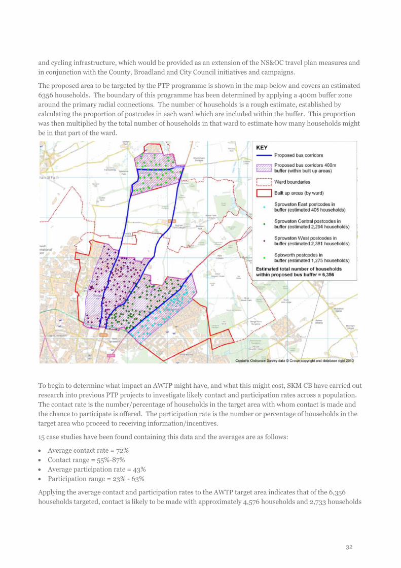
The proposed area to be targeted by the PTP programme is shown in the map below and covers an estimated 6356 households. The boundary of this programme has been determined by applying a 400m buffer zone around the primary radial connections. The number of households is a rough estimate, established by calculating the proportion of postcodes in each ward which are included within the buffer. This proportion was then multiplied by the total number of households in that ward to estimate how many households might be in that part of the ward.
To begin to determine what impact an AWTP might have, and what this might cost, SKM CB have carried out research into previous PTP projects to investigate likely contact and participation rates across a population. The contact rate is the number/percentage of households in the target area with whom contact is made and the chance to participate is offered. The participation rate is the number or percentage of households in the target area who proceed to receiving information/incentives.
15 case studies have been found containing this data and the averages are as follows:
• Average contact rate = 72% • Contact range = 55%-87% • Average participation rate = 43% • Participation range = 23% - 63%
Applying the average contact and participation rates to the AWTP target area indicates that of the 6,356 households targeted, contact is likely to be made with approximately 4,576 households and 2,733 households
32
are likely to participate and receive information and/or incentives. The costs associated with this are discussed in Appendix 2.
Clearly there is a big range in the success of the various PTP methodologies and the programme will be designed to take these into account. In particular, the methodologies can involve making telephone calls, going door-to-door or a combination of the two.
Telephone contact is the least expensive and could result in higher contact rates due to the ability to undertake more contact attempts within the budget, but there is significant potential for some demographic groups to be under-represented, for example as some households (e.g. students) may no longer use landline telephones. On the other hand, door-to-door contact means all households can potentially be contacted and the quality of engagement with door-to-door contact is also likely to be greater in terms of more contacted households being converted in to participants and greater mode shift subsequently being achieved, making this a much more effective method in terms of delivering mode shift. Therefore, despite its higher costs of door-to-door contact, it is likely that door-to-door contact would be used due to the potential for it to achieve higher contact and participation rates and therefore potentially induce greater mode shift.
The door-to-door approach would then follow SKM’s ‘personal responsibility’ methodology. SKM’s tried-and-tested approach to voluntary behaviour change involves PTP participants being encouraged, through conversations with specially-trained Travel Advisors, to articulate a travel problem they experience in their daily lives and then work out how this problem could be overcome. For example, if the participant is spending too much money every month on car travel, the Travel Advisor could help them to identify journeys which could be shared with a colleague or neighbour, then calculate how much could be saved if done on a regular basis. The materials delivered to the participant are then very specific to that solution, therefore rendering them more useful than generic information or incentives, and therefore more likely to initiate behaviour change.
9.3.2 Workplace travel planning at the Airport Industrial Estate Using the Census 2001 data for the Old Catton ward within which the Airport Industrial area is situated, it has been calculated that (excluding those working from home), there are approximately 8,200 people travelling to this area for employment. The travel mode share of these employees is: 85% travel by car, 3% by public transport, 7% by bicycle and 5% on foot.
This indicates significant propensity for change through the introduction of a targeted workplace travel plan strategy, alongside improvements to infrastructure and promotion of new infrastructure delivered through NATS. It is recommended that the workplace travel plan strategy would involve:
• a Workplace Travel Plan Officer to support Travel Plan Co-ordinators at the various organisations; • car sharing scheme; • site-specific travel information; • cycling initiatives such as Dr Bike, workplace cycle challenges and Bike Buddies etc.
As discussed, this would be best led by the Norfolk County Council in line with their existing workplace travel plan initiatives, but could effectively link into the travel planning initiatives at NS&OC.
9.4 Potential impact of AWTPs
9.4.1 Making Personalised Travel Planning Work: Research Report (2007) In 2007, the DfT published ‘Making Personal Travel Planning Work: Research Report” which is generally accepted as the most robust study into the effect of PTP in the UK. Within the study, a number of projects
33
were reviewed and PTP practitioners were interviewed. It was concluded that in the UK PTP reduced car driver trips by 11% (amongst the targeted population) and the distance travelled by car was reduced by 12%. This translates to a 4% percentage point reduction in car mode share. Walking was found to be the main beneficiary, gaining an average mode share increase of +3%.
9.4.2 Sustainable Travel Demonstration Towns As the AWTP will promote the on-site and off-site (in the long-term) sustainable travel infrastructure and local services improvements, it is also useful to look at the Sustainable Travel Demonstration Towns (STDT) programme.
Through this project, three UK towns (Peterborough, Worcester and Darlington) implemented Smarter Choices programmes including infrastructure and bus service improvements as well as travel information and marketing campaigns. Whilst it is acknowledged that the STDT projects were carried out across the whole town, as opposed to the NS&OC AWTP proposals, the results of these projects can provide an indication of the potential impact of an integrated area-wide programme.
Each town chose how much to spend on each of a range of different measures; all three towns spent the most on PTP (from a third to nearly half of revenue spending), followed by travel awareness campaigns, promoting walking and cycling, public transport marketing, then smaller amounts on workplace and school travel plans.
Across the three towns, car driver trips by residents fell by 9% per person, and car driver distance by 5%~7%. This compares with a fall of about 1% in car driver trips in medium-sized urban areas over the same period. Across the three towns, the mode shift was 4%-6% from car to sustainable modes.
9.4.3 PTP in west Norwich (UEA CIVITAS project) A PTP project has been carried out in Norwich previously and whilst the mode shift achievements were inconclusive, the following qualitative findings can be applied to this project:
• The main reasons for travelling by car were convenience, lack of an alternative or car being essential for job.
• The main reasons for not travelling by car were health and fitness, most practical and ‘enjoy the alternatives’.
• Financial savings as well as health and fitness reasons were judged to be the most popular messages for encouraging behaviour change.
• 1/3 of respondents did not feel safe cycling. 10% did not feel safe walking. • PTP raised awareness of cycle routes from 42% to 78%.
The evaluation recommended that in future longer term incentives should be offered (First offered ‘taster’ bus tickets). It was also recommended that information is ‘drip fed’ throughout the year, with monitoring undertaken 12 months after the initial survey.
9.4.4 Area-based workplace travel plan network example – Cambridge Science Park This initiative is as good example of the results that can be achieved through a coordinated approach to workplace travel planning at a commercial area on the outskirts of a city. It shows the results that smarter travel marketing can bring in a location which has traditionally very low rail and bus use (2% and 3%, respectively) and an abundance of free parking.
The network of organisations on the Cambridge Science Park is coordinated by staff who are based full-time in a Commuter Centre on site. The project is part of the Travel Plan Plus project, which aims to set up travel plan networks in four varying situations across Europe to share their findings and experience across the
34
continent. The project is funded by Intelligent Energy Europe programme which comes from the European Commission's Executive Agency for Competitiveness and Innovation.
Over 7 months 18 roadshows were run which were visited by 845 commuters, gained feedback on barriers and solved some practical travel issues (such as improving cycle access onto the site) through working with colleagues in the City Council. This has helped to raise their credibility as an effective and useful organisation.
Site-wide travel surveys are carried out annually in October. Overall, 52 workplaces have taken part in the project at some stage, with 14 taking part in the surveys in both October 2009 and October 2010. The mode shift results are derived only from the survey results of these 14 businesses in order to compare like with like. In this time the project has seen a -5% mode shift from SOV travel (from 58%), a 4% increase in cycling (from 17%), 2% increase in walking and 1% increase in working from home. There has also been a further decrease in rail and bus use, each falling by 1%.
9.5 Summary
The proposed AWTP would cover an area of approximately 6,356 households and potentially around 8,200 employees in Old Catton (including the Airport Industrial area). The main measure would be implementation of a Personalised Travel Planning project, with workplace travel planning for the employment sites. These initiatives would enhance the wider sustainable travel campaigns and infrastructure improvements led by Norwich and Norfolk City Councils, as well as those being implemented on the NS&OC site.
Using averages from previous PTP projects, it is estimated that across the 6,357 households targeted, approximately 43% might be expected to participate and receive information/initiatives. The evidence from previous PTP projects and the STDT programmes indicates that a thorough AWTP project (including marketing and travel information) implemented in the existing residential areas adjacent to the development could result in around a 4% mode shift away from car driver mode share, or an 11% reduction in car driver trips (across the targeted population). If the programme included improvements to services and infrastructure, this could result in approximately 4-6% mode shift away from car driver to sustainable modes or 9% across all residents.
35
10 MONITORING
10.1 Data collection
The monitoring and review of the travel plan and area-wide travel plan will be the responsibility of the Travel Plan Coordinator for each travel plan, who will work with an independent consultant to ensure results are reliable and consistent. The monitoring methodology will remain consistent throughout the life of the travel plan and across the various occupiers to ensure comparability of results over time and land use.
The primary method for monitoring the travel plan will be household/employee travel surveys. The travel surveys will provide quantitative and qualitative data to allow progress towards the mode shift targets to be measured. The surveys will be carried out on an annual basis, roughly at the same time of year each year. Surveys will be timed to ensure ‘average’ travel conditions, i.e. during term time in either the spring or autumn. Annual surveys will continue throughout the life of the travel plan, with less formal monitoring carrying on as the travel plan becomes voluntary.
Car and cycle parking usage will be monitored primarily on a more informal basis within the development. All public cycle parking areas will be monitored during peak times to ensure they do not exceed 85% capacity. Peak demand for cycle parking at a residential development is likely to occur during the evenings, when residents have returned from work, school and leisure trips. If demand regularly exceeds capacity then more cycle parking will be provided.
The uptake of any vouchers or discounts will be tracked by the Travel Plan Coordinator, who will keep a count of the number of residents/households or employees who have taken these up.
10.1.2 Monitoring schedule The initial travel survey will take place at 100% occupation of Phase 1, with further monitoring surveys taking place thereafter on an annual basis for 5 years. At this time, presuming targets are met, a final report will be submitted. The travel plan will continue to be implemented and monitored by the Travel Plan Coordinator, with support from the County and City Councils.
10.2 Reporting
An Annual Monitoring Report for each individual travel plan will be submitted to Norfolk County Council (and Broadland District Council and Norwich City Council if requested). The report will detail the findings of the monitoring surveys as well as a description of the activities that have been undertaken in the past year, an assessment of the performance of the travel plan in reference to the objectives and targets and an action plan for how the travel plan will be taken forward over the next year.
The Annual Monitoring Report will be the responsibility of the Travel Plan Coordinators for each individual travel plan, with assistance from the Site-wide Travel Plan Coordinator for the smaller occupiers and the school as required. The Site-wide Travel Plan Coordinator will also take the role of residential Travel Plan Coordinator, so will be responsible for residential travel surveys.
The results of the more informal monitoring, such as any feedback received by the Site-wide Travel Plan Coordinator over the year, uptake of any vouchers or discounts and BUG membership, will also be incorporated into their Annual Monitoring Report.
36
10.3 Remedial measures
The Annual Monitoring Reports will be vital in indicating whether remedial measures need to be introduced at the site. Remedial measures will be triggered if the travel plan targets do not appear to be on track to be met within the prescribed timescales and the travel plan fails to progress towards meeting its targets between two consecutive monitoring surveys.
The process for putting remedial measures into action will be written in the S106 agreement. This will be linked to the achievements of the AWTP, which is to be introduced to mitigate the impact of the development and help achieve traffic neutrality.
If the final travel plan target is not met, then the travel plan implementation, funded by the developer, will continue for a further 3 years or until the targets are met, whichever is earlier. The situation will be reassessed after 3 years and further remedial measures taken if necessary, funded by the developer. The remedial measures required will depend upon which aspects of the travel plan are not performing as well as they should.
37
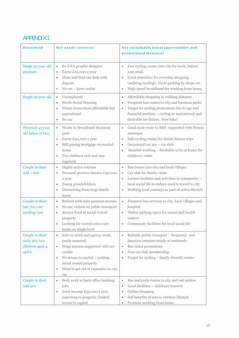
APPENDIX 1
Household Key needs/ interests Key sustainable travel opportunities and promotional measures
Single 23 year old graduate
• Ex-UEA graphic designer • Earns £25,000 a year • Mum and Dad can help with
deposit • No car – keen cyclist
• Fast cycling routes into city for work, leisure and retail.
• Local amenities for everyday shopping (walking/cycling). Cycle parking by shops etc.
• High speed broadband for working from home.
Single 26 year old • Unemployed • Needs Social Housing • Wants somewhere affordable but
aspirational • No car
• Affordable shopping in walking distance • Frequent bus routes to city and business parks • Target for cycling promotions due to age and
financial position – cycling as aspirational and desirable for fitness. Free bike?
Divorced 45 year old father of two
• Works in Broadband Business park
• Earns £40,000 a year • Still paying mortgage on marital
home • Two children visit and stay
regularly
• Good cycle route to BBP, supported with fitness messages
• Safe cycling routes for family leisure trips • Occasional car use – car club • Smarter working – flexibility to be at home for
children’s visits
Couple in their mid – 60s
• Highly active retirees • Personal pension income £30,000
a year • Young grandchildren • Downsizing from large family
home
• Bus routes into city and local villages • Car club for family visits • Leisure facilities and activities in community –
local social life to reduce need to travel to city • Walking local journeys as part of active lifestyle
Couple in their late 70s, one needing care
• Retired with state pension income • No car, reliant on public transport • Always lived in social rented
property • Looking for rented extra-care
home on single level
• Frequent bus services to city, local villages and hospital
• Visitor parking space for carers and health visitors
• Community facilities for local social life
Couple in their early 30s, two children aged 4 and 6
• Jobs in retail and agency work, partly seasonal
• Wage income supported with tax credits
• No access to capital – seeking social rented property
• Want to get rid of expensive to run car
• Reliable public transport – frequency and duration remains steady at weekends
• Bus ticket promotions • Free car club membership • Target for cycling – family-friendly routes
Couple in their mid 20s
• Both work in back office banking jobs
• Joint income £35,000 a year, expecting to progress; limited access to capital
• Bus and cycle routes to city and rail station • Local facilities – childcare/nursery • Online shopping • Sell benefits of active, outdoor lifestyle • Promote working from home
38
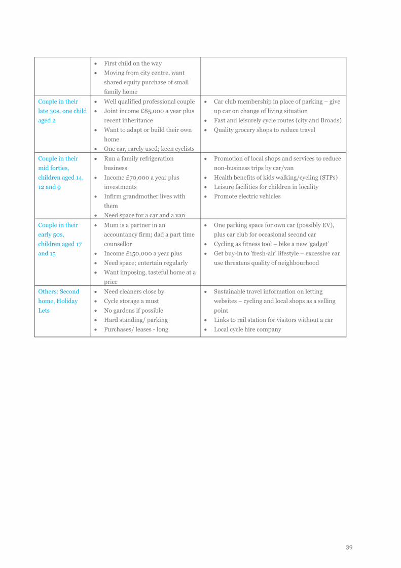
• First child on the way • Moving from city centre, want
shared equity purchase of small family home
Couple in their late 30s, one child aged 2
• Well qualified professional couple • Joint income £85,000 a year plus
recent inheritance • Want to adapt or build their own
home • One car, rarely used; keen cyclists
• Car club membership in place of parking – give up car on change of living situation
• Fast and leisurely cycle routes (city and Broads) • Quality grocery shops to reduce travel
Couple in their mid forties, children aged 14, 12 and 9
• Run a family refrigeration business
• Income £70,000 a year plus investments
• Infirm grandmother lives with them
• Need space for a car and a van
• Promotion of local shops and services to reduce non-business trips by car/van
• Health benefits of kids walking/cycling (STPs) • Leisure facilities for children in locality • Promote electric vehicles
Couple in their early 50s, children aged 17 and 15
• Mum is a partner in an accountancy firm; dad a part time counsellor
• Income £150,000 a year plus • Need space; entertain regularly • Want imposing, tasteful home at a
price
• One parking space for own car (possibly EV), plus car club for occasional second car
• Cycling as fitness tool – bike a new ‘gadget’ • Get buy-in to ’fresh-air’ lifestyle – excessive car
use threatens quality of neighbourhood
Others: Second home, Holiday Lets
• Need cleaners close by • Cycle storage a must • No gardens if possible • Hard standing/ parking • Purchases/ leases - long
• Sustainable travel information on letting websites – cycling and local shops as a selling point
• Links to rail station for visitors without a car • Local cycle hire company
39
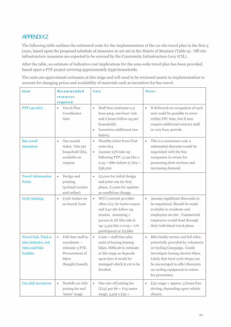
APPENDIX 2 The following table outlines the estimated costs for the implementation of the on-site travel plan in the first 5 years, based upon the proposed schedule of measures as set out in the Matrix of Measure (Table 9). Off-site infrastructure measures are expected to be covered by the Community Infrastructure Levy (CIL).
After the table, an estimate of indicative cost implications for the area-wide travel plan has been provided, based upon a PTP project covering approximately 6356 households.
The costs are approximate estimates at this stage and will need to be reviewed nearer to implementation to account for changing prices and availability of materials such as incentives for bus travel.
Item Recommended resources required
Cost Notes
PTP (on-site) • Travel Plan Coordinator time
• Staff time (estimate 0.5 hour prep, one hour visit and 2 hours follow-up per household).
• Incentives additional (see below).
• If delivered on occupation of each unit could be possible to cover within TPC time, but if may require additional contract staff in very busy periods.
Bus travel incentives
• One month ticket. One per household (hh), available on request.
• Monthly ticket from First costs £64
• Assume 25% take up following PTP: 3,159 hhs x 0.25 = 880 tickets @ £64 = £56,320
• This is a maximum cost; a substantial discount would be negotiated with the bus companies in return for promoting their services and increasing demand.
Travel Information Packs
• Design and printing (printed version and online)
• £5,000 for initial design and print run for first phase, £1,000 for updates as conditions change.
Cycle training • Cycle trainer on an hourly basis
• NCC’s current provider offers £15 1hr taster course and £40 2hr follow-up session. Assuming 1 person in 5% hhs take it up: 3,519 hhs x 0.05 = 176 participants @ £9,680
• Assume significant discounts to be negotiated. Should be made available to residents and employees on-site. Commercial employers would fund through their individual travel plans.
Travel hub, Trial-a-bike initiative, led rides and bike buddies
• Full time staff to coordinate – estimate 3 FTE. Procurement of bikes (bought/leased).
• Costs = staff time plus costs of buying/leasing bikes. Difficult to estimate at this stage as depends upon how it would be managed which is yet to be decided.
• Bike buddy service and led rides, potentially provided by volunteers or Cycling Campaign. Could investigate leasing electric bikes. Likely that local cycle shops can be encouraged to offer discounts on cycling equipment in return for promotion.
Car club incentives • Norfolk car club joining fee and ‘taster’ usage
• One one-off joining fee (£25) per hh + £25 taster usage. 3,519 x £50 =
• £25 usage = approx. 5 hours free driving, depending upon vehicle chosen.
40
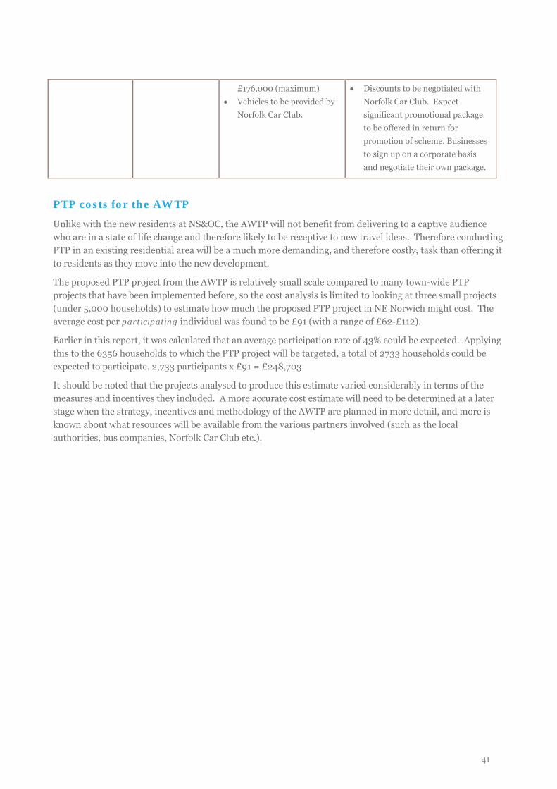
£176,000 (maximum) • Vehicles to be provided by
Norfolk Car Club.
• Discounts to be negotiated with Norfolk Car Club. Expect significant promotional package to be offered in return for promotion of scheme. Businesses to sign up on a corporate basis and negotiate their own package.
PTP costs for the AWTP
Unlike with the new residents at NS&OC, the AWTP will not benefit from delivering to a captive audience who are in a state of life change and therefore likely to be receptive to new travel ideas. Therefore conducting PTP in an existing residential area will be a much more demanding, and therefore costly, task than offering it to residents as they move into the new development.
The proposed PTP project from the AWTP is relatively small scale compared to many town-wide PTP projects that have been implemented before, so the cost analysis is limited to looking at three small projects (under 5,000 households) to estimate how much the proposed PTP project in NE Norwich might cost. The average cost per participating individual was found to be £91 (with a range of £62-£112).
Earlier in this report, it was calculated that an average participation rate of 43% could be expected. Applying this to the 6356 households to which the PTP project will be targeted, a total of 2733 households could be expected to participate. 2,733 participants x £91 = £248,703
It should be noted that the projects analysed to produce this estimate varied considerably in terms of the measures and incentives they included. A more accurate cost estimate will need to be determined at a later stage when the strategy, incentives and methodology of the AWTP are planned in more detail, and more is known about what resources will be available from the various partners involved (such as the local authorities, bus companies, Norfolk Car Club etc.).
41