Embed Size (px)
Citation preview
101245.00 ● Addendum Report ● September 2011
NSTIR - Antigonish Wetland Compensation Project Wetland Compensation Proposal
& Baseline Inventory Report
ISO 9001
Registered Company
Prepared by: Prepared for:
NS Department of Transportation and Infrastructure Renewal
101245 00-LE-002 (GILLIS NSE)(FINAL EDITS).DOC/PC ED: 9/30/2011 11:39:00 AM/PD: 9/30/2011 11:39:00 AM
1489 Hollis Street
PO Box 606
Halifax, Nova Scotia
Canada B3J 2R7
Telephone: 902 421 7241
Fax: 902 423 3938
E-mail: [email protected]
www.cbcl.ca
ISO 9001
Registered Company
30 September 2011
File No. 111245
Mr. Sean Gillis, BSc, CET
Inspector Specialist
Nova Scotia Environment
155 Main Street, Suite 205
Antigonish, NS B2G 2B6
Dear Mr. Gillis:
RE: Addendum of Additional Information and Detailed Design for the Antigonish
Wetlands Compensation Project Application – (Reference - NSE Approval to
Construct – Wetland Alteration Brierly Brook – Approval # 2009-066003).
The attached report is an addendum to the Antigonish Wetland Compensation Project
Proposal (November 16, 2010) submitted by CBCL Limited on behalf of the NS Department
of Transportation and Infrastructure Renewal (NSTIR), as part of the conditions set out in
the above-referenced NSE permit approval. This addendum describes, in further detail, the
type of wetland compensation being proposed for the Antigonish Wetland Compensation
Project. The addendum should be read in conjunction with the earlier proposal, which
presents a baseline study of the general habitats found at the Antigonish Landing, wetland
delineation and functional assessment, flood mapping and avian survey within the study
area, as well as a conceptual compensation plan for the enhancement and creation of
wetlands and the development of an interpretive walking trail. The addendum should be
considered as a replacement for Chapter Five – Antigonish Wetland Compensation Project,
of the earlier report.
It should be noted that the larger project that NSTIR has initiated at the Antigonish Landing
includes seven main components: the acquisition of lands immediately adjacent to the
Antigonish Wildlife Management Area for the purposes of wetlands compensation, wetlands
restoration and enhancement, new wetland interpretive trail, bank armourment on both
the Rights and West Rivers, and an Invasive Alien Plant Program for the management of
Japanese knotweed. All of these components involve long-term monitoring programs. This
addendum specifically addresses the wetlands restoration and enhancement compensation
project at the Landing.
Mr. Gillis 30 September 2011
Page 2
101245 00-LE-002 (GILLIS NSE)(FINAL EDITS).DOC/PC ED: 9/30/2011 11:39:00 AM/PD: 9/30/2011 11:39:00 AM
I trust that this addendum clarifies any outstanding questions you may have with regard to
the proposed compensation project. It is NSTIR’s intention to undertake certain portions of
the proposed work during this (2011) construction season provided approvals can be
secured from NSE and DFO. If you have any questions pertaining to the proposal or
attached addendum, please do not hesitate to contact me.
Yours very truly,
CBCL Limited
Clinton Pinks, CSLA
Wetland Delineator, Landscape Architect
Direct: (902) 421-7241 ext: 2256
E-Mail: [email protected]
Attachment
cc:
John Brazner, Wetland/Water Specialist ([email protected])
Paul Keats, District Manager ([email protected])
Charles MacInnis, Area Chief, DFO ([email protected])
Dr. Alan Hanson, CWS ([email protected])
Mark Pulsifer, Wildlife Biologist, NSNR ([email protected])
Dr. Bob Pett, NSTIR ([email protected])
CBCL Limited 101245 – Antigonish Landing Wetland Compensation – Addendum - Contents i
Addendum Contents
CHAPTER 1 Antigonish Wetlands Compensation Project ............................................................... 1
1.1 Introduction ........................................................................................................................ 1
1.2 Overall Compensation Project ............................................................................................ 1
1.3 Study Area - North and South Compensation Sites ............................................................ 1
1.4 The North Site – Wetland Restoration................................................................................ 4
1.4.1 Rationale and Design .............................................................................................. 4
1.4.2 AML-1 Wetland Characterization ........................................................................... 5
1.5 The South Site – Wetland Enhancement ............................................................................ 6
1.5.1 Rationale and Design .............................................................................................. 6
1.5.2 Trail System ............................................................................................................. 6
1.6 Detailed Design for Ponds, Channels and Wetland Vegetation ......................................... 7
1.7 Compensation Wetland Monitoring Program .................................................................. 10
1.7.1 North Site .............................................................................................................. 10
1.7.2 South Site .............................................................................................................. 11
Appendices A Antigonish Landing North – Tidal Restriction Analysis and Flood Mapping
CBCL Limited Antigonish Wetlands Compensation Project 1
CHAPTER 1 ANTIGONISH WETLANDS COMPENSATION
PROJECT
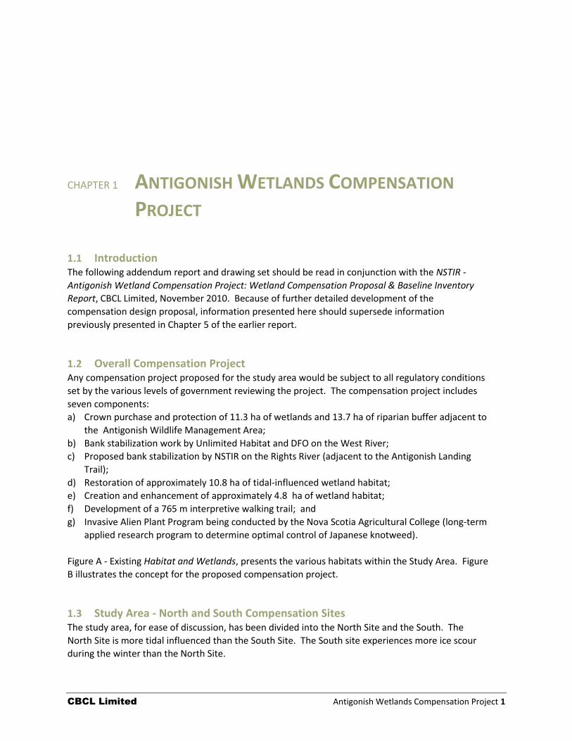
1.1 Introduction The following addendum report and drawing set should be read in conjunction with the NSTIR -
Antigonish Wetland Compensation Project: Wetland Compensation Proposal & Baseline Inventory
Report, CBCL Limited, November 2010. Because of further detailed development of the
compensation design proposal, information presented here should supersede information
previously presented in Chapter 5 of the earlier report.
1.2 Overall Compensation Project Any compensation project proposed for the study area would be subject to all regulatory conditions
set by the various levels of government reviewing the project. The compensation project includes
seven components:
a) Crown purchase and protection of 11.3 ha of wetlands and 13.7 ha of riparian buffer adjacent to
the Antigonish Wildlife Management Area;
b) Bank stabilization work by Unlimited Habitat and DFO on the West River;
c) Proposed bank stabilization by NSTIR on the Rights River (adjacent to the Antigonish Landing
Trail);
d) Restoration of approximately 10.8 ha of tidal-influenced wetland habitat;
e) Creation and enhancement of approximately 4.8 ha of wetland habitat;
f) Development of a 765 m interpretive walking trail; and
g) Invasive Alien Plant Program being conducted by the Nova Scotia Agricultural College (long-term
applied research program to determine optimal control of Japanese knotweed).
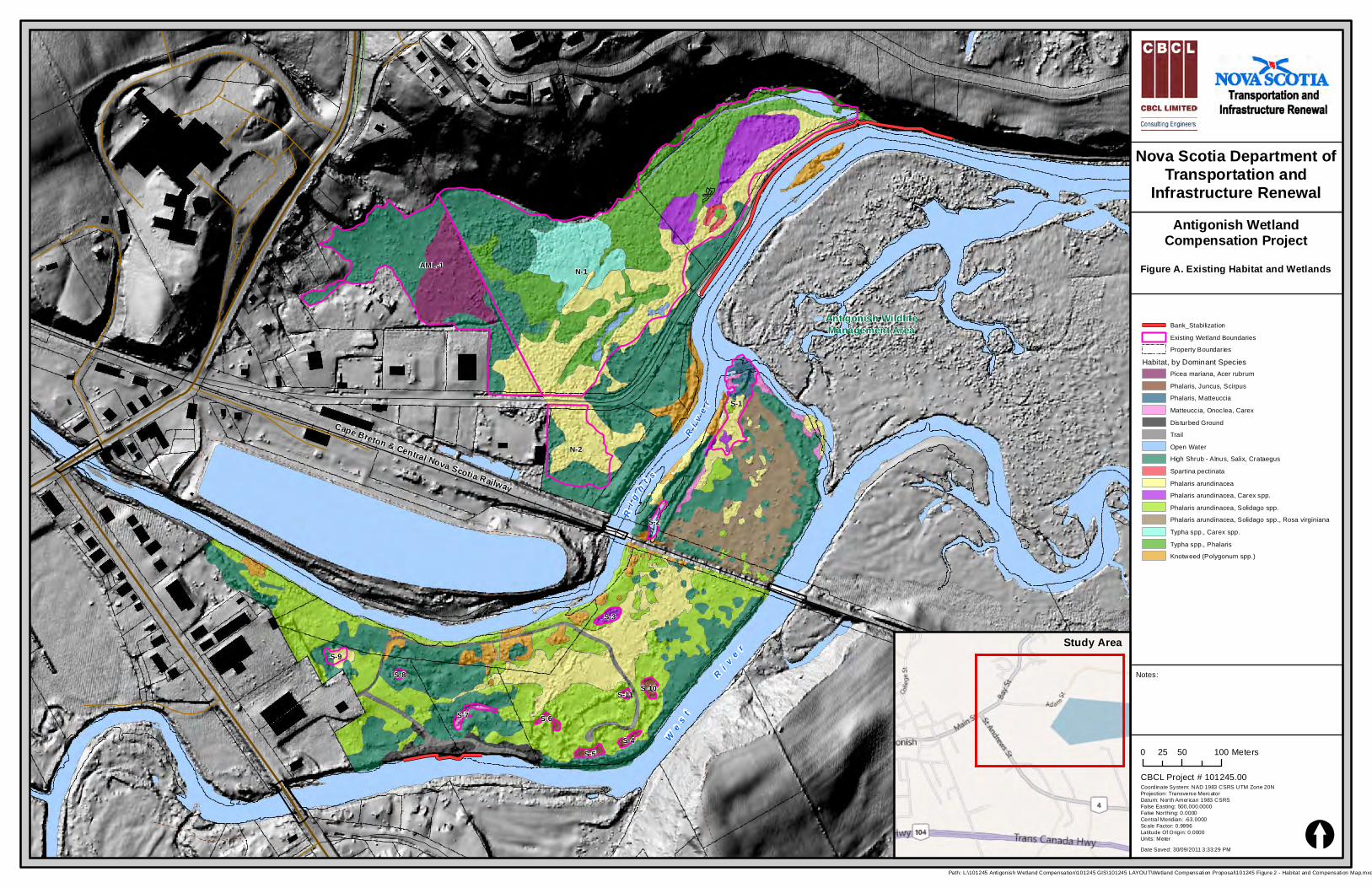
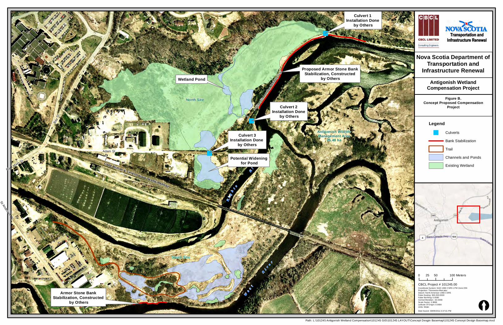
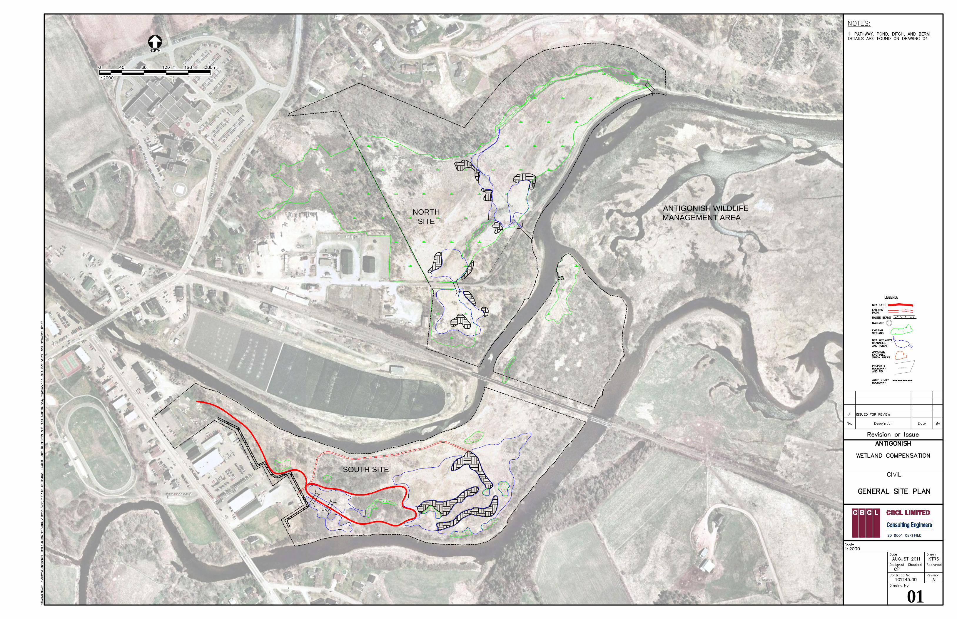
Figure A - Existing Habitat and Wetlands, presents the various habitats within the Study Area. Figure
B illustrates the concept for the proposed compensation project.
1.3 Study Area - North and South Compensation Sites The study area, for ease of discussion, has been divided into the North Site and the South. The
North Site is more tidal influenced than the South Site. The South site experiences more ice scour
during the winter than the North Site.
Nova Scotia Department ofTransportation and
Infrastructure RenewalAntigonish Wetland
Compensation Project
Ri g
h t s Ri v e
r
We s t R i v e r
Antigonish WildlifeManagement Area
Cape Breton & Central Nova Scotia Railway
N-1AML-1
N-2
S-1
S-7
S-9
S-3
S-2
S-5
S-10
S-4
S-6
S-8
S-11
0 50 10025 Meters
[
Notes:
Date Saved: 30/09/2011 3:33:29 PM
Coordinate System: NAD 1983 CSRS UTM Zone 20NProjection: Transverse MercatorDatum: North American 1983 CSRSFalse Easting: 500,000.0000False Northing: 0.0000Central Meridian: -63.0000Scale Factor: 0.9996Latitude Of Origin: 0.0000Units: Meter
Path: L:\101245 Antigonish Wetland Compensation\101245 GIS\101245 LAYOUT\Wetland Compensation Proposal\101245 Figure 2 - Habitat and Compensation Map.mxd
CBCL Project # 101245.00
Bank_StabilizationExisting Wetland BoundariesProperty Boundaries
Habitat, by Dominant SpeciesPicea mariana, Acer rubrumPhalaris, Juncus, ScirpusPhalaris, MatteucciaMatteuccia, Onoclea, CarexDisturbed GroundTrailOpen WaterHigh Shrub - Alnus, Salix, CrataegusSpartina pectinataPhalaris arundinaceaPhalaris arundinacea, Carex spp.Phalaris arundinacea, Solidago spp.Phalaris arundinacea, Solidago spp., Rosa virginianaTypha spp., Carex spp.Typha spp., PhalarisKnotweed (Polygonum spp.)
Study Area
Figure A. Existing Habitat and Wetlands
Nova Scotia Department ofTransportation and
Infrastructure RenewalAntigonish Wetland
Compensation Project
"
"
"
Ri g
h t s Ri v e r
We s t
R i v e r
Antigonish WildlifeManagement Area
25.48 ha
Cape Breton & Central Nova Scotia Railway
Adam St.
East Main St.
St Andrews St.
Antigoni
sh Lan
ding W
alking
Trail
Bay S
t.
North Site
South Site
")
")
Potential Widening for Pond
Wetland Pond
Proposed Armor Stone BankStabilization, Constructed
by Others
Culvert 2Installation Done
by Others
Culvert 1Installation Done
by Others
Culvert 3Installation Done
by Others
Armor Stone BankStabilization, Constructed
by Others
0 50 10025 Meters
[Date Saved: 30/09/2011 3:37:31 PM
Coordinate System: NAD 1983 CSRS UTM Zone 20NProjection: Transverse MercatorDatum: North American 1983 CSRSFalse Easting: 500,000.0000False Northing: 0.0000Central Meridian: -63.0000Scale Factor: 0.9996Latitude Of Origin: 0.0000Units: Meter
Path: L:\101245 Antigonish Wetland Compensation\101245 GIS\101245 LAYOUT\Concept Desgin Basemap\101245 Concept Design Basemap.mxd
CBCL Project # 101245.00
Figure B.Concept Proposed Compensation
Project
Study Area
Legend" Culverts
Bank StabilizationTrailChannels and PondsExisting Wetland
CBCL Limited Antigonish Wetlands Compensation Project 2
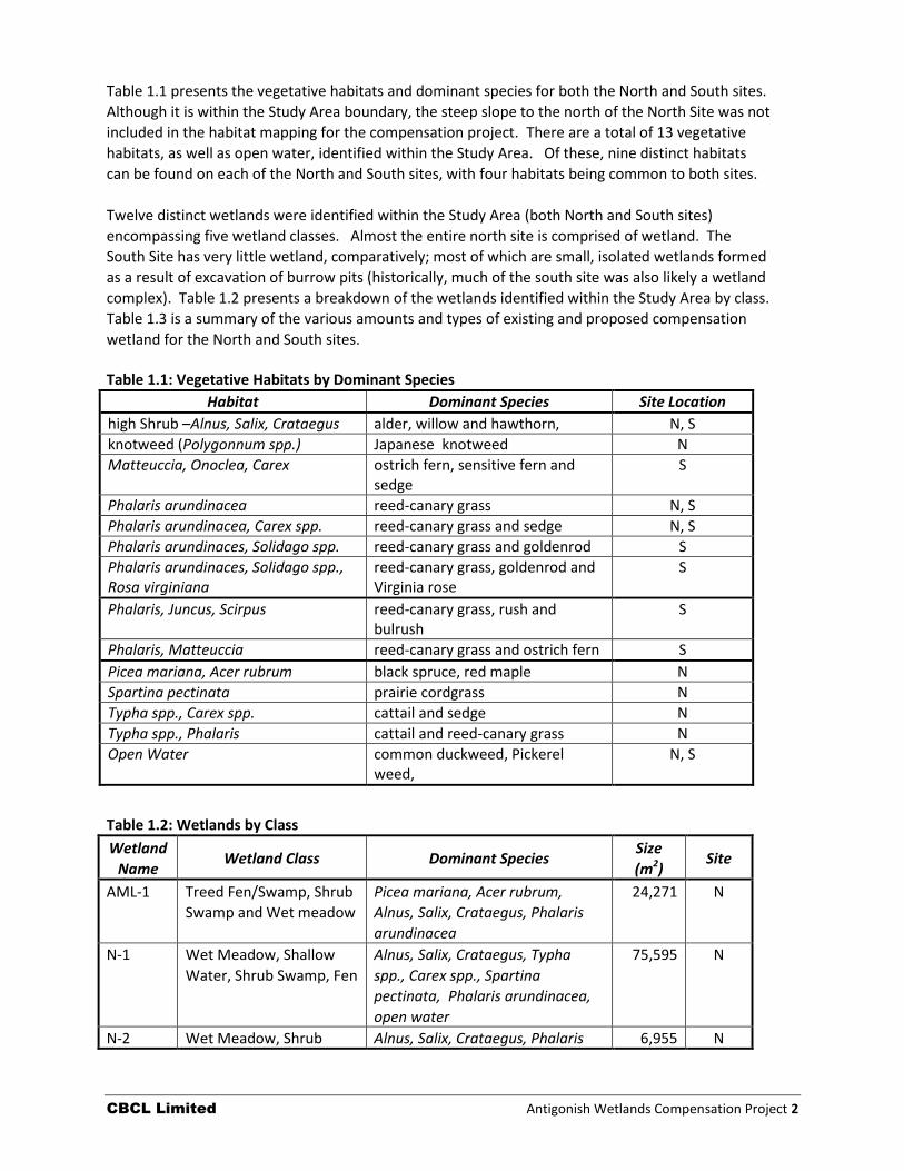
Table 1.1 presents the vegetative habitats and dominant species for both the North and South sites.
Although it is within the Study Area boundary, the steep slope to the north of the North Site was not
included in the habitat mapping for the compensation project. There are a total of 13 vegetative
habitats, as well as open water, identified within the Study Area. Of these, nine distinct habitats
can be found on each of the North and South sites, with four habitats being common to both sites.
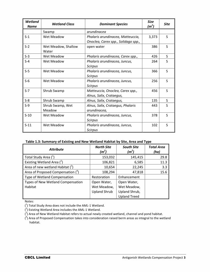
Twelve distinct wetlands were identified within the Study Area (both North and South sites)
encompassing five wetland classes. Almost the entire north site is comprised of wetland. The
South Site has very little wetland, comparatively; most of which are small, isolated wetlands formed
as a result of excavation of burrow pits (historically, much of the south site was also likely a wetland
complex). Table 1.2 presents a breakdown of the wetlands identified within the Study Area by class.
Table 1.3 is a summary of the various amounts and types of existing and proposed compensation
wetland for the North and South sites.
Table 1.1: Vegetative Habitats by Dominant Species
Habitat Dominant Species Site Location
high Shrub –Alnus, Salix, Crataegus alder, willow and hawthorn, N, S
knotweed (Polygonnum spp.) Japanese knotweed N
Matteuccia, Onoclea, Carex ostrich fern, sensitive fern and sedge
S
Phalaris arundinacea reed-canary grass N, S
Phalaris arundinacea, Carex spp. reed-canary grass and sedge N, S
Phalaris arundinaces, Solidago spp. reed-canary grass and goldenrod S
Phalaris arundinaces, Solidago spp., Rosa virginiana
reed-canary grass, goldenrod and Virginia rose
S
Phalaris, Juncus, Scirpus reed-canary grass, rush and bulrush
S
Phalaris, Matteuccia reed-canary grass and ostrich fern S
Picea mariana, Acer rubrum black spruce, red maple N
Spartina pectinata prairie cordgrass N
Typha spp., Carex spp. cattail and sedge N
Typha spp., Phalaris cattail and reed-canary grass N
Open Water common duckweed, Pickerel weed,
N, S
Table 1.2: Wetlands by Class
Wetland
Name Wetland Class Dominant Species
Size
(m2) Site
AML-1 Treed Fen/Swamp, Shrub
Swamp and Wet meadow
Picea mariana, Acer rubrum,
Alnus, Salix, Crataegus, Phalaris
arundinacea
24,271 N
N-1 Wet Meadow, Shallow
Water, Shrub Swamp, Fen
Alnus, Salix, Crataegus, Typha
spp., Carex spp., Spartina
pectinata, Phalaris arundinacea,
open water
75,595 N
N-2 Wet Meadow, Shrub Alnus, Salix, Crataegus, Phalaris 6,955 N
CBCL Limited Antigonish Wetlands Compensation Project 3
Wetland
Name Wetland Class Dominant Species
Size
(m2) Site
Swamp arundinacea
S-1 Wet Meadow Phalaris arundinacea, Matteuccia,
Onoclea, Carex spp., Solidago spp.,
3,373 S
S-2 Wet Meadow, Shallow
Water
open water 386 S
S-3 Wet Meadow Phalaris arundinacea, Carex spp., 426 S
S-4 Wet Meadow Phalaris arundinacea, Juncus,
Scirpus
264 S
S-5 Wet Meadow Phalaris arundinacea, Juncus,
Scirpus
366 S
S-6 Wet Meadow Phalaris arundinacea, Juncus,
Scirpus
256 S
S-7 Shrub Swamp Matteuccia, Onoclea, Carex spp.,
Alnus, Salix, Crataegus,
456 S
S-8 Shrub Swamp Alnus, Salix, Crataegus, 135 S
S-9 Shrub Swamp, Wet
Meadow
Alnus, Salix, Crataegus, Phalaris
arundinacea,
443 S
S-10 Wet Meadow Phalaris arundinacea, Juncus,
Scirpus
378 S
S-11 Wet Meadow Phalaris arundinacea, Juncus,
Scirpus
102 S
Table 1.3: Summary of Existing and New Wetland Habitat by Site, Area and Type
Attribute North Site
(m2)
South Site
(m2)
Total Area
(ha)
Total Study Area (1) 153,032 145,415 29.8
Existing Wetland Area (2) 106,821 6,585 11.3
Area of new wetland Habitat (3) 10,654 22,245 3.3
Area of Proposed Compensation (4) 108,294 47,818 15.6
Type of Wetland Compensation Restoration Enhancement
Types of New Wetland Compensation
Habitat
Open Water,
Wet Meadow,
Upland Shrub
Open Water,
Wet Meadow,
Upland Shrub,
Upland Treed
Notes: (
1) Total Study Area does not include the AML-1 Wetland.
(2) Existing Wetland Area includes the AML-1 Wetland.
(3) Area of New Wetland Habitat refers to actual newly created wetland, channel and pond habitat.
(4) Area of Proposed Compensation takes into consideration raised berm areas as integral to the wetland
habitat.
CBCL Limited Antigonish Wetlands Compensation Project 4
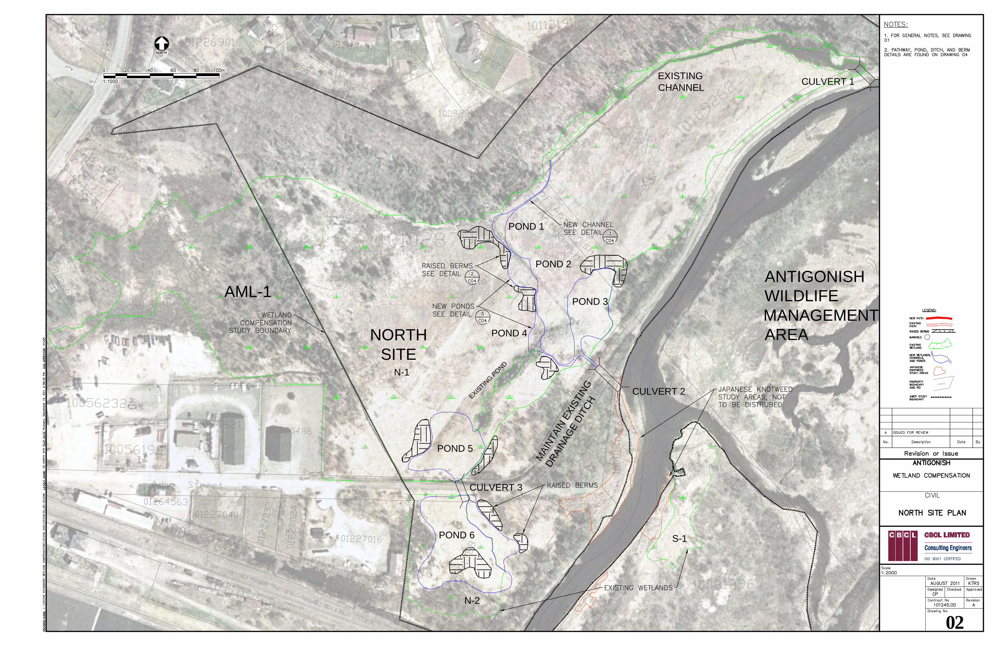
1.4 The North Site – Wetland Restoration
1.4.1 Rationale and Design
Most of the North Site is wetland. The Antigonish Landing Road Trail, used as a walking trail today,
defines the southern boundary of a large wetland expanse on the North Site (N-1; 7.56 ha)). This
wetland is further defined along its northern boundary by a steep, forested slope. The wetland,
largely comprised of wet meadow, fen and shrub swamp, is connected to the Rights River by an
existing 1,500 mm, corrugated metal pipe (CMP) culvert (Culvert 1 in Figure B). Currently tidal-
waters enter the North Site through Culvert 1 at the north-eastern end of the site and follow an
existing channel along the northern perimeter of the wetland where it terminates. Changes in
elevation of the waters within the channel can be easily seen daily.
There is a smaller culvert (Culvert 2; 450 mm CMP) towards the western end of the site; however, it
does not provide a connection between Wetland N-1 and the Rights River. Instead, it appears to
direct drainage from the end of Adam Street and the upland parking area, via a shallow ditch on the
north side of the Landing Road and then into Rights River.
A second smaller wetland (N-2) lies south of the Landing Road and is separated from N-1 by the
road. Wetland N-2 (0.7 ha) does not receive tidal waters. To the west of the Study Area lies a 2.4 ha
extension of Wetland N-1. Because it is beyond the Study Area this portion of the wetland is
referred to as AML-1. The total amount of exiting wetland for all three wetlands is 10.6 ha.
It is quite conceivable that Wetlands N-1, N-2 and AML-1 were, at one time, a large contiguous tidal
wetland at the mouth of the Rights River, perhaps similar to that found today within the Antigonish
Wildlife Management Area. With the construction of the Landing Road and single culvert crossing,
tidal influence has been significantly modified or lost over time. Agricultural practices, land use,
ditching and infilling have altered the wetland. Improving the connection between the wetlands
and the river would restore much of the functions that have been lost over time.
Appendix A provides a tidal restriction analysis for the culvert crossing, connecting Wetland N-1 to
the river. Analysis showed that the maximum water level recorded during the period of 18
November 2010 and 3 December 2010 was approximately 1.5 m. Water levels within Wetland N-1
were found to be, on average, 11.6 cm higher than downstream (Rights River) water levels. Most
tides higher than 0.9 m showed a delay in peak tide (within the wetland) of between five and 25
minutes after the recorded tide downstream. With the highest recorded tide of 1.5 m, the wetland
experienced a 15-minute delay in peak tide. The peak tide was 9.7 cm higher within the wetland
than the river. Although there was a significant temporal delay of 15 minutes, loss of tidal prism
was probably not significant.
Because Wetland N-1 is defined (and separated) by the Landing Road Trail, tides greater than 1.7 m,
which is the approximate height of the road, will overtop the road and flood the wetland, regardless
of the size of crossing. Predictive modelling and analysis suggest that for tides less than 1 m,
flooding would continue to be confined to the existing channel within the wetland, regardless of size
of crossing. However, increasing the crossing size to approximately 4 m would improve the flushing
of the wetland system following a large flood event, decrease residency time for flood waters within
the system, improve fish passage and transport of materials into and out of the wetland, and reduce
flood risk of the adjacent properties. Making a second crossing from the river to the wetland
CBCL Limited Antigonish Wetlands Compensation Project 5
(Culvert 2; approximately 2 m wide) and extending the existing channel to connect the two culverts
would further restore the flushing of the wetland and fish habitat. Including open water areas
(ponds) within the new channel section will restore open water habitat for wildlife. Placement of a
third culvert (Culvert 3; 1.2 m) under the Landing Trail and a connecting channel back to Culvert 2
would reconnect Wetland N-2 to Wetland N-1. Two large open-water ponds on either side of
Culvert 3 will also restore and enhance diversity in both Wetland N-2 and N-1. Overall, wetland
compensation will provide a total of 10.8 ha of restored, tidal-influenced wetland habitat. NSTIR
proposes to carry-out this work during October 2011 to March 2012 (October-November 2011 for
the three culverts with excavation work for ponds and channels during winter, frozen-ground
periods).
While NSTIR have chosen to pursue the design of the culvert installations, the attached drawings
present the design for the proposed channels, ponds and wetland fringes for the North Site. Further
discussion about the wetland design is described below. 1.4.2 AML-1 Wetland Characterization Wetland AML-1, which lies on lands owned by the Asset Management Ltd., is the western portion of the much larger wetland N-1. AML-1 comprises 2.43 ha of wetland habitat consisting of Treed Fen/ Swamp, Shrub Swamp and Wet Meadow. A significant portion of the wetland AML-1 is a mixed-wood treed fen with peat deposits in excess of 1.22 m (48”). These deposits support a mature stand of trees dominated by red maple with lesser amounts of black spruce and tamarack and a diverse shrub and herbaceous understory. The southeastern tip of AML-1 is comprised mainly of shrub swamp (dominated by speckled alder and red maple) and wet meadow (dominated by reed-canary grass with lesser amounts of cattails and various sedges), both of which extend onto the NSTIR portion of the wetland (See Figure A). In the westernmost portion of the wetland, the deep peat deposits yield to a mineral soil substrate supporting a dense growth of speckled alder. AML-1 is receiving a modest amount of inflow via a drainage corridor at the northern tip, adjacent to the large area of fill along the property’s border with Bay St. It is assumed that the wetland is receiving significant groundwater discharge from the base of Mt. Cameron, as well as surface water runoff from Mt. Cameron and the lots along both Adam and Bay Streets. A significant drainage ditch has been excavated along the southern boundary of the property, which presumably collects water from the various gravelled lots along Adam St. There is no distinct watercourse leading through the wetland, however an existing tidal-influenced channel does eventually form down-gradient on the NSTIR lands, at the toe of slope to Mt. Cameron. Sampling within the wetland showed the water table to be between 150 mm and 400 mm below surface. Surface water was observed at many locations throughout the wetland. The wetlands location at the fringe of the Rights River floodplain suggests that portions of it may occasionally be inundated with floodwaters during extreme storm or tidal events. No species of conservation concern were encountered during the survey, although no exhaustive inventory surveys for flora and fauna were conducted for the purposes of this delineation. It is known that the adjacent NSTIR portion of the wetland (N-1) is fairly biodiverse in terms of flora and fauna, and does contain the uncommon species coffee-tinkers weed (Triosteum aurantiacum). It is very likely that the downgradient portion of wetland N-1, which is tidally influenced and contains a distinct channel, is fish habitat. As such, the upgradient portions of N-1 and AML-1 may be important in maintaining water quality/quantity for this area. Overall, it is considered that wetland
CBCL Limited Antigonish Wetlands Compensation Project 6
AML-1 is relatively rich in terms of its habitat value, due to its structural diversity and proximity to N-1 and the Antigonish Wildlife Management Area.
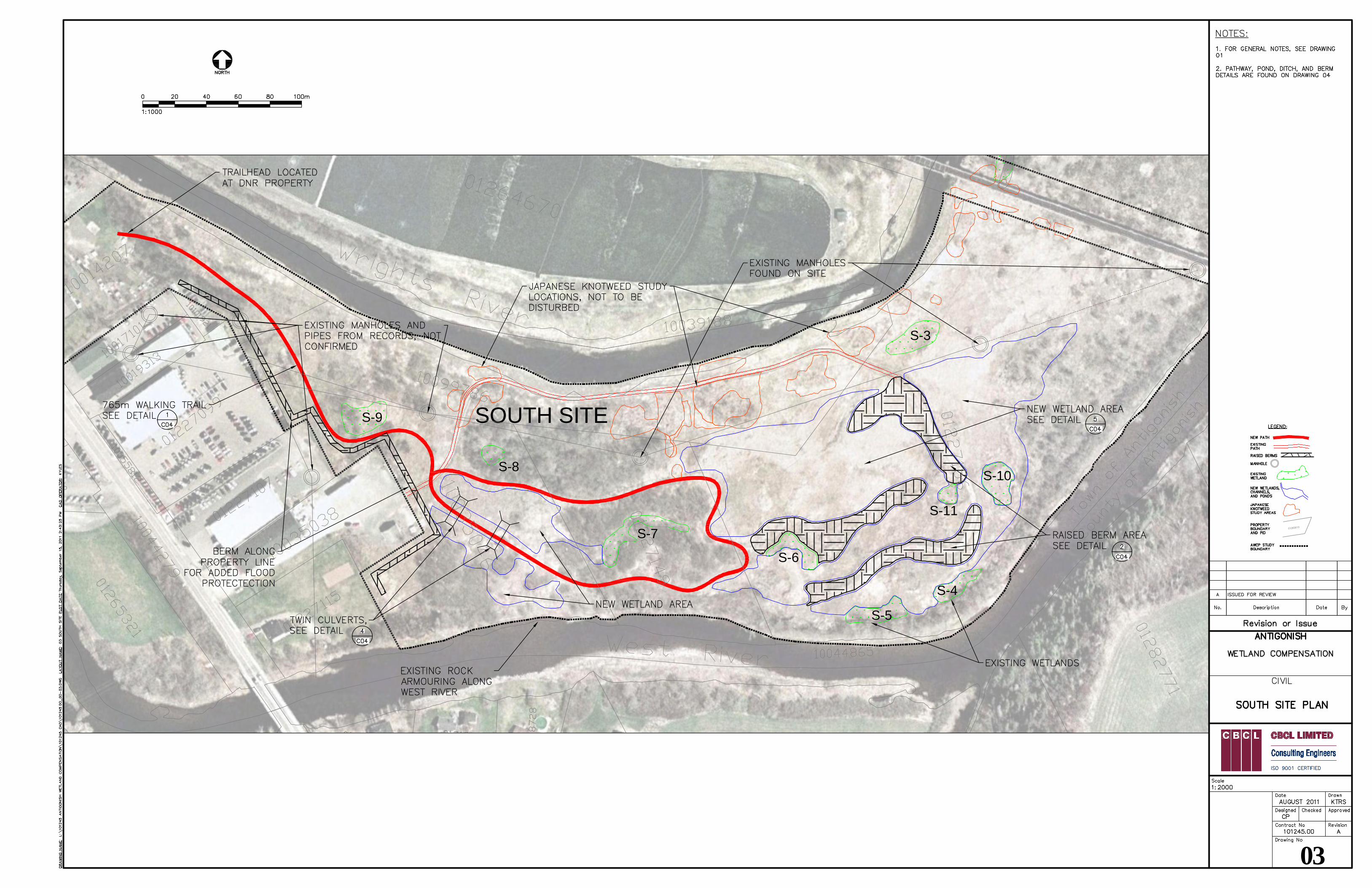
1.5 The South Site – Wetland Enhancement
1.5.1 Rationale and Design
The South Site is defined by the Rights River to the north and the West River to the south. The Cape
Breton and Central Nova Scotia Railway (CBCNSR) further defines the northern boundary of the area
of enhancement for purposes of construction logistics, access and safety. The South Site is largely a
floodplain that is manicured seasonally by ice scour, caused mostly from ice coming from the Rights
River. As a result, there are very few stands of riparian trees on the floodplain. Historically, the
Rights River has been realigned and channelized to help the Town reduce the risk of flooding each
spring. Over time, the floodplain of the South Site has been largely used for agricultural purposes.
There are no current activities on site today. However, recent activities left behind remnants of haul
roads used to harvest topsoil. Topsoil harvesting occurred up until quite recently in the site’s
history. This practice created depressions within the landscape that, left alone, appear to be
groundwater charged and capable of sustaining wetland vegetation and other wetland processes.
Field work demonstrated that digging a soil pit in tight clay loam soils down to gravels (no greater
than a metre) would typically cause water to fill the pit to within a few centimetres of the surface.
A matrix of nine, small (300 square metres +/-) and isolated, freshwater wetlands were identified
south of the CBCNSR. These wetlands, together, occupy a total of 0.65 ha. Most of these are slight
impressions on the floodplain as a result of topsoil harvesting. Described as Wet Meadow wetlands,
their plant communities generally consist of Phalaris, Juncus, Scirpus and Carex species. Very little
open water exists on the South Site.
Wetland compensation on the South Site will be achieved through the enhancement of the wetland
matrix by connecting the individual wetlands together. Enhancement would involve creating
shallow, open water ponds and depressions within the floodplain adjacent to the existing wetlands,
similar to what is currently observed on site. Ponds and depressions would be carefully graded to
address critical water elevations and plant communities. The wetland compensation would provide
a total of 4.8 ha of enhanced wetland habitat. Wetland enhancement is intended to boost the
ecological integrity of the South Site and provide habitat for waterfowl, herpetiles (amphibians and
reptiles) and aquatic biota. This work is planned for Summer 2012.
1.5.2 Trail System
Project compensation also proposes developing a soft-surface interpretative walking trail on the
South Site. Approximately 765 m in length, the trail would be raised above the landscape no greater
than 200 mm to reduce any impediment to flooding. Useable excavation from the wetland
enhancement project would be used to build the shallow berm onto which the trail would be set.
Excess material would be strategically placed in and around the wetlands to create relief and
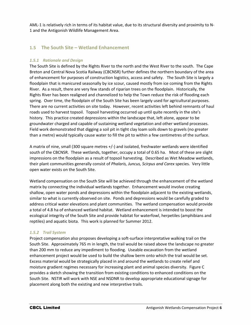
moisture gradient regimes necessary for increasing plant and animal species diversity. Figure C
provides a sketch showing the transition from existing conditions to enhanced conditions on the
South Site. NSTIR will work with NSE and NSDNR to develop appropriate educational signage for
placement along both the existing and new interpretive trails.
CBCL Limited Antigonish Wetlands Compensation Project 7
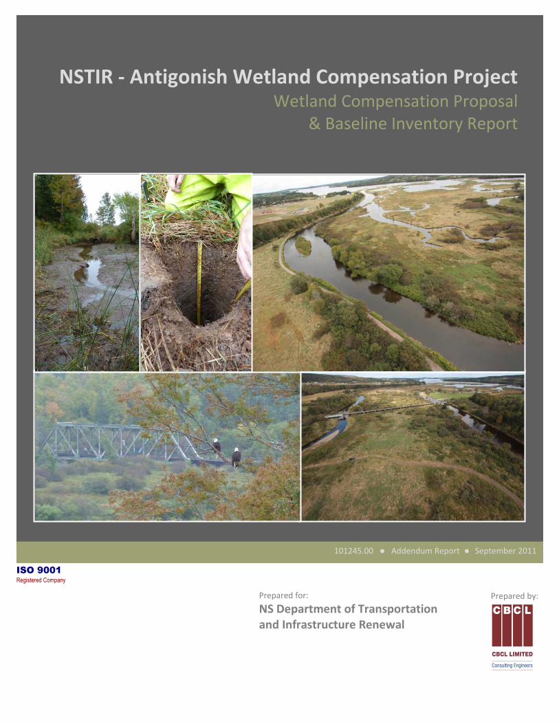
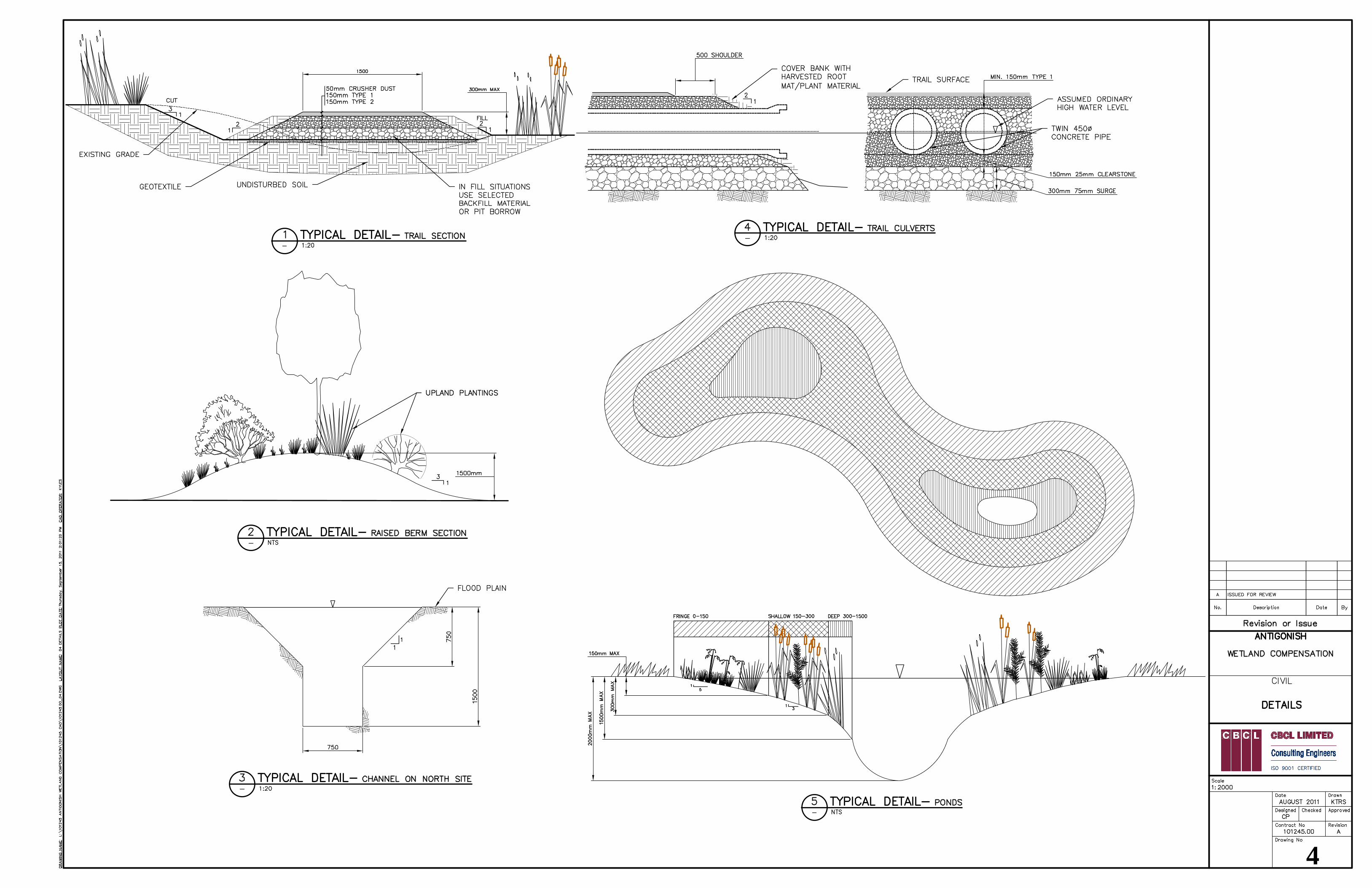
1.6 Detailed Design for Ponds, Channels and Wetland Vegetation The proposed compensation effort includes a total of six ponds and wetland habitat areas to be
constructed on the North Site and three more to be built on the South Site. The attached drawing
set provides the detailed design for the various wetland compensation components. The design of
the ponds is intended to maintain a central open water area, free of vegetation. The open water
area will be surrounded by different plant communities, depending on their moisture regime.
Design of gradual side slopes (20 percent) around the ponds is to allow a broad moisture gradient at
the edge that will encourage the establishment of a greater diversity of wetland plant species. Side
slopes are designed to be steeper closer to the center of the ponds. This is also designed for safe
approach purposes. As depicted in the drawing set, for both the North Site and South sites, three
planting zones within the wetland
will be established for most ponds:
fringe (water depth < 150 mm),
shallow water (water depth < 300
mm) and deep water (< 1500
mm). Open water habitat
(unplanted) will be controlled
through depth of water. In this
instance ponds will have a
maximum depth of 2,000 mm.
Berms, created using the
excavated materials will have a
maximum height of 1,500 mm
with side slopes of 33 percent and
would provide opportunity for the
establishment of upland plant
communities. Other species
identified will be best suited to
revegetating the floodplain
around the wetland matrix on the
South Site.
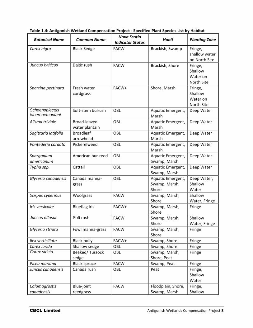
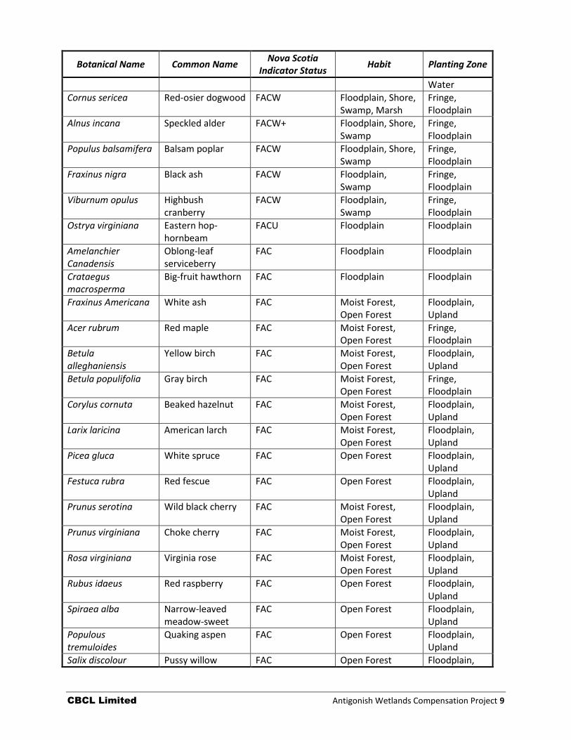
Table 1.4 presents a list of possible
plant species selected for
colonizing the various wetland
ponds and berms within the North
and South sites. This list is largely
developed from species observed
in the local area. Plantings are
listed as upland, wetland/ pond
fringe, shallow water and deep
water, for purposes of placement
in design. Final selection of
plantings will be based on
availability and substitutions may
be likely.
Figure C: Showing wetland enhancement on the South Site
CBCL Limited Antigonish Wetlands Compensation Project 8
Table 1.4: Antigonish Wetland Compensation Project - Specified Plant Species List by Habitat
Botanical Name Common Name Nova Scotia
Indicator Status Habit Planting Zone
Carex nigra Black Sedge FACW Brackish, Swamp Fringe, shallow water on North Site
Juncus balticus Baltic rush FACW Brackish, Shore Fringe, Shallow Water on North Site
Spartina pectinata Fresh water cordgrass
FACW+ Shore, Marsh Fringe, Shallow Water on North Site
Schoenoplectus tabernaemontani
Soft-stem bulrush OBL Aquatic Emergent, Marsh
Deep Water
Alisma triviale Broad-leaved water plantain
OBL Aquatic Emergent, Marsh
Deep Water
Sagittaria latifolia Broadleaf arrowhead
OBL Aquatic Emergent, Marsh
Deep Water
Pontederia cordata Pickerelweed OBL Aquatic Emergent, Marsh
Deep Water
Sparganium americanum
American bur-reed OBL Aquatic Emergent, Swamp, Marsh
Deep Water
Typha spp. Cattail OBL Aquatic Emergent, Swamp, Marsh
Deep Water
Glyceria canadensis Canada manna-grass
OBL Aquatic Emergent, Swamp, Marsh, Shore
Deep Water, Shallow Water
Scirpus cyperinus Woolgrass FACW Swamp, Marsh, Shore
Shallow Water, Fringe
Iris versicolor Blueflag iris FACW+ Swamp, Marsh, Shore
Fringe
Juncus effusus Soft rush FACW Swamp, Marsh, Shore
Shallow Water, Fringe
Glyceria striata Fowl manna-grass FACW Swamp, Marsh, Shore
Fringe
Ilex verticillata Black holly FACW+ Swamp, Shore Fringe
Carex lurida Shallow sedge OBL Swamp, Shore Fringe Carex stricta Beaked/ Tussock
sedge OBL Swamp, Marsh,
Shore, Peat Fringe
Picea mariana Black spruce FACW Swamp, Peat Fringe
Juncus canadensis Canada rush OBL Peat Fringe, Shallow Water
Calamagrostis canadensis
Blue-joint reedgrass
FACW Floodplain, Shore, Swamp, Marsh
Fringe, Shallow
CBCL Limited Antigonish Wetlands Compensation Project 9
Botanical Name Common Name Nova Scotia
Indicator Status Habit Planting Zone
Water
Cornus sericea Red-osier dogwood FACW Floodplain, Shore, Swamp, Marsh
Fringe, Floodplain
Alnus incana Speckled alder FACW+ Floodplain, Shore, Swamp
Fringe, Floodplain
Populus balsamifera Balsam poplar FACW Floodplain, Shore, Swamp
Fringe, Floodplain
Fraxinus nigra Black ash FACW Floodplain, Swamp
Fringe, Floodplain
Viburnum opulus Highbush cranberry
FACW Floodplain, Swamp
Fringe, Floodplain
Ostrya virginiana Eastern hop-hornbeam
FACU Floodplain Floodplain
Amelanchier Canadensis
Oblong-leaf serviceberry
FAC Floodplain Floodplain
Crataegus macrosperma
Big-fruit hawthorn FAC Floodplain Floodplain
Fraxinus Americana White ash FAC Moist Forest, Open Forest
Floodplain, Upland
Acer rubrum Red maple FAC Moist Forest, Open Forest
Fringe, Floodplain
Betula alleghaniensis
Yellow birch FAC Moist Forest, Open Forest
Floodplain, Upland
Betula populifolia Gray birch FAC Moist Forest, Open Forest
Fringe, Floodplain
Corylus cornuta Beaked hazelnut FAC Moist Forest, Open Forest
Floodplain, Upland
Larix laricina American larch FAC Moist Forest, Open Forest
Floodplain, Upland
Picea gluca White spruce FAC Open Forest Floodplain, Upland
Festuca rubra Red fescue FAC Open Forest Floodplain, Upland
Prunus serotina Wild black cherry FAC Moist Forest, Open Forest
Floodplain, Upland
Prunus virginiana Choke cherry FAC Moist Forest, Open Forest
Floodplain, Upland
Rosa virginiana Virginia rose FAC Moist Forest, Open Forest
Floodplain, Upland
Rubus idaeus Red raspberry FAC Open Forest Floodplain, Upland
Spiraea alba Narrow-leaved meadow-sweet
FAC Open Forest Floodplain, Upland
Populous tremuloides
Quaking aspen FAC Open Forest Floodplain, Upland
Salix discolour Pussy willow FAC Open Forest Floodplain,
CBCL Limited Antigonish Wetlands Compensation Project 10
Botanical Name Common Name Nova Scotia
Indicator Status Habit Planting Zone
Upland
Ulmus Americana American Elm FAC Open Forest Floodplain, Upland
Populous grandidentata
Large-tooth aspen FACU- Open Forest Upland
Betula papyrifera White birch FACU Open Forest Upland
Sambucus racemosa Red elderberry FACU Open Forest Upland
Quercus rubra Northern red oak FACU Open Forest Upland
Fagus grandiflia American beech UPL Open Forest Upland
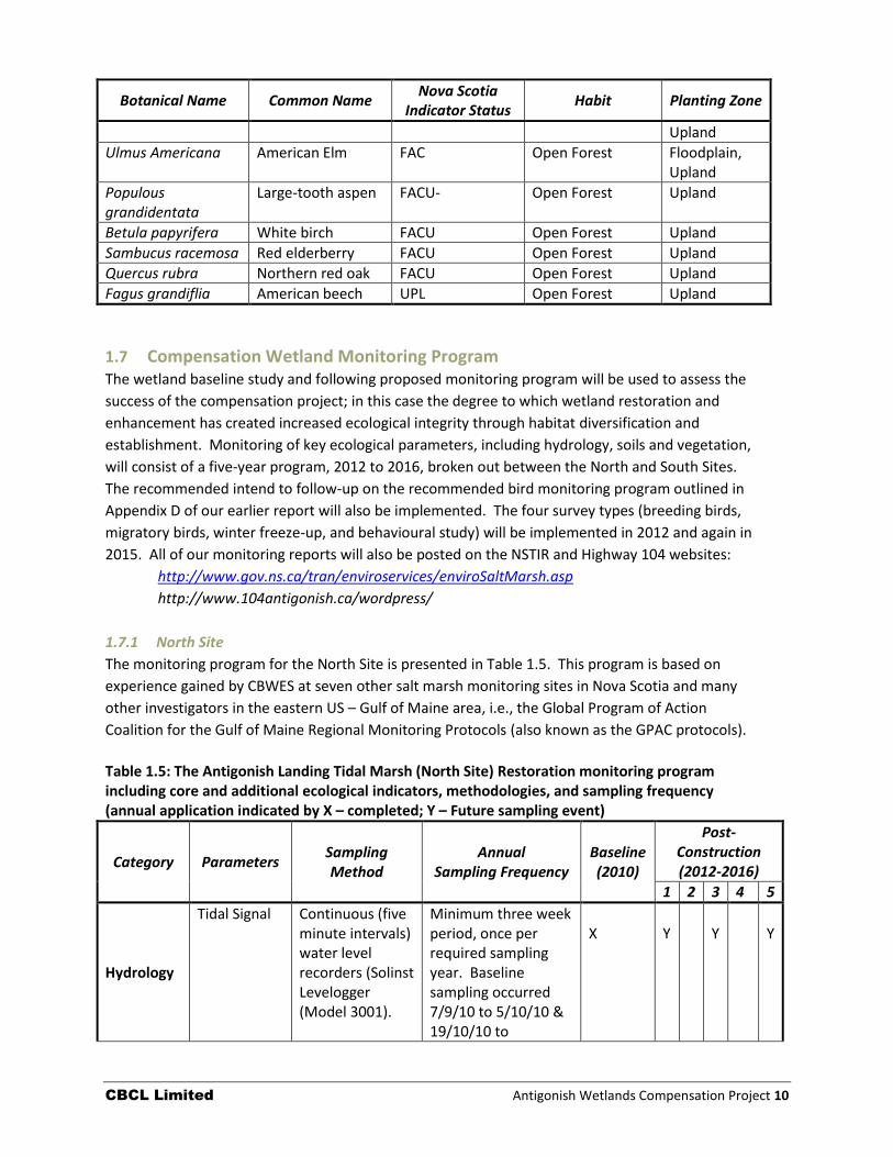
1.7 Compensation Wetland Monitoring Program The wetland baseline study and following proposed monitoring program will be used to assess the
success of the compensation project; in this case the degree to which wetland restoration and
enhancement has created increased ecological integrity through habitat diversification and
establishment. Monitoring of key ecological parameters, including hydrology, soils and vegetation,
will consist of a five-year program, 2012 to 2016, broken out between the North and South Sites.
The recommended intend to follow-up on the recommended bird monitoring program outlined in
Appendix D of our earlier report will also be implemented. The four survey types (breeding birds,
migratory birds, winter freeze-up, and behavioural study) will be implemented in 2012 and again in
2015. All of our monitoring reports will also be posted on the NSTIR and Highway 104 websites:
http://www.gov.ns.ca/tran/enviroservices/enviroSaltMarsh.asp
http://www.104antigonish.ca/wordpress/
1.7.1 North Site
The monitoring program for the North Site is presented in Table 1.5. This program is based on
experience gained by CBWES at seven other salt marsh monitoring sites in Nova Scotia and many
other investigators in the eastern US – Gulf of Maine area, i.e., the Global Program of Action
Coalition for the Gulf of Maine Regional Monitoring Protocols (also known as the GPAC protocols).
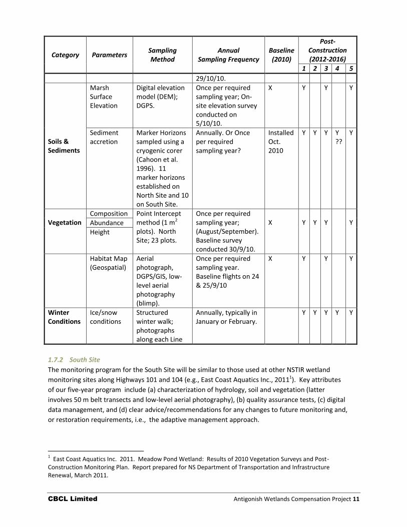
Table 1.5: The Antigonish Landing Tidal Marsh (North Site) Restoration monitoring program including core and additional ecological indicators, methodologies, and sampling frequency (annual application indicated by X – completed; Y – Future sampling event)
Category Parameters Sampling Method
Annual Sampling Frequency
Baseline (2010)
Post-Construction (2012-2016)
1 2 3 4 5
Hydrology
Tidal Signal Continuous (five minute intervals) water level recorders (Solinst Levelogger (Model 3001).
Minimum three week period, once per required sampling year. Baseline sampling occurred 7/9/10 to 5/10/10 & 19/10/10 to
X
Y
Y
Y
CBCL Limited Antigonish Wetlands Compensation Project 11
Category Parameters Sampling Method
Annual Sampling Frequency
Baseline (2010)
Post-Construction (2012-2016)
1 2 3 4 5
29/10/10.
Soils & Sediments
Marsh Surface Elevation
Digital elevation model (DEM); DGPS.
Once per required sampling year; On-site elevation survey conducted on 5/10/10.
X Y Y Y
Sediment accretion
Marker Horizons sampled using a cryogenic corer (Cahoon et al. 1996). 11 marker horizons established on North Site and 10 on South Site.
Annually. Or Once per required sampling year?
Installed Oct. 2010
Y Y Y Y ??
Y
Vegetation
Composition Point Intercept method (1 m2 plots). North Site; 23 plots.
Once per required sampling year; (August/September). Baseline survey conducted 30/9/10.
X
Y
Y
Y
Y
Abundance
Height
Habitat Map (Geospatial)
Aerial photograph, DGPS/GIS, low-level aerial photography (blimp).
Once per required sampling year. Baseline flights on 24 & 25/9/10
X Y Y Y
Winter Conditions
Ice/snow conditions
Structured winter walk; photographs along each Line
Annually, typically in January or February.
Y Y Y Y Y
1.7.2 South Site
The monitoring program for the South Site will be similar to those used at other NSTIR wetland
monitoring sites along Highways 101 and 104 (e.g., East Coast Aquatics Inc., 20111). Key attributes
of our five-year program include (a) characterization of hydrology, soil and vegetation (latter
involves 50 m belt transects and low-level aerial photography), (b) quality assurance tests, (c) digital
data management, and (d) clear advice/recommendations for any changes to future monitoring and,
or restoration requirements, i.e., the adaptive management approach.
1 East Coast Aquatics Inc. 2011. Meadow Pond Wetland: Results of 2010 Vegetation Surveys and Post-
Construction Monitoring Plan. Report prepared for NS Department of Transportation and Infrastructure Renewal, March 2011.
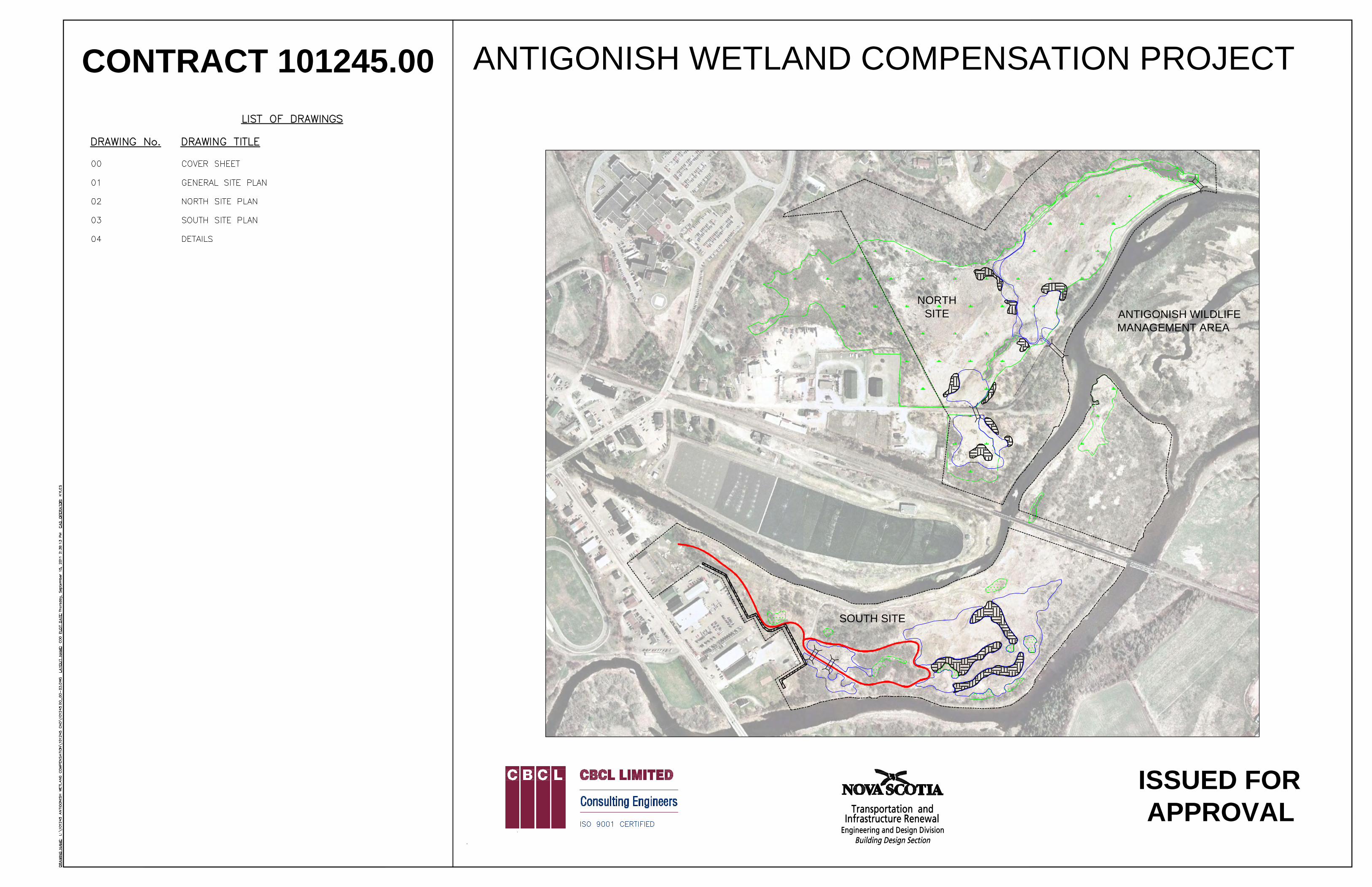
CONTRACT 101245.00 ANTIGONISH WETLAND COMPENSATION PROJECT
ISSUED FORAPPROVAL
NORTHSITE
SOUTH SITE
ANTIGONISH WILDLIFEMANAGEMENT AREA
01
NORTHSITE
SOUTH SITE
ANTIGONISH WILDLIFEMANAGEMENT AREA
NORTHSITE
ANTIGONISHWILDLIFEMANAGEMENTAREA
POND 1
POND 2
POND 3
POND 4
CULVERT 1
CULVERT 2
POND 5
POND 6
CULVERT 3
EXISTINGCHANNEL
MAI
NTAI
N EX
ISTI
NG
DRAI
NAGE
DITC
H
AML-1
N-2
S-1
N-1
EXISTING POND
02
SOUTH SITE
S-3
S-4
S-5
S-6
S-7
S-8
S-9
S-11
S-10
03
4
CBCL Limited Appendices
APPENDIX A
Tidal Restriction Analysis and Flood Mapping
Tony Bowron 5679 Harris Street Halifax NS B3K 1H3 (902) 431-5772 [email protected] Nancy Neatt 331 Newbury Road Hammonds Plains NS B4B 0C6 (902) 443-3589 [email protected]
CBWES Inc.
www.cbwes.com May 17, 2011
To: Clinton Pinks CBCL Ltd. Re: Antigonish Landing North – Tidal Restriction Analysis and Flood Mapping.
Dear Mr. Pinks: Please find enclosed a copy of the tidal restriction analysis and flood mapping for the Antigonish Landing North Site as part of the NSTIR – Antigonish Wetland Compensation Project (baseline inventory report). Part I: Antigonish North Site – Tidal Restriction Analysis Part II: Antigonish North Site – Flood Map and Restoration Scenarios Sincerely,
Tony M. Bowron Director, Coastal Wetland Ecologist CBWES Inc.
Antigonish Wetland Compensation CBWES Inc.
Antigonish Landing North – Tidal Restriction Analysis and Flood Mapping 1
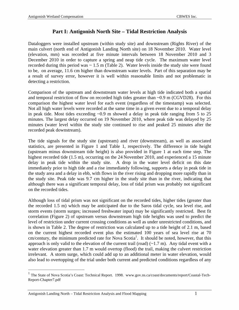
Part I: Antigonish North Site – Tidal Restriction Analysis
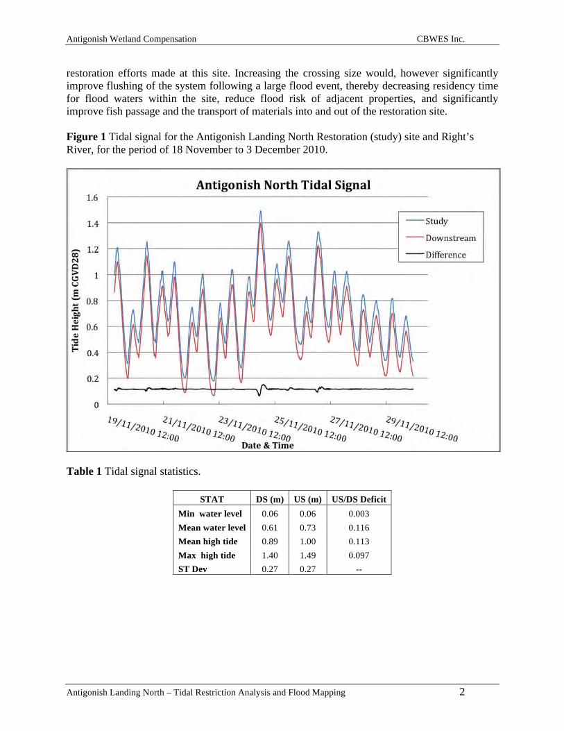
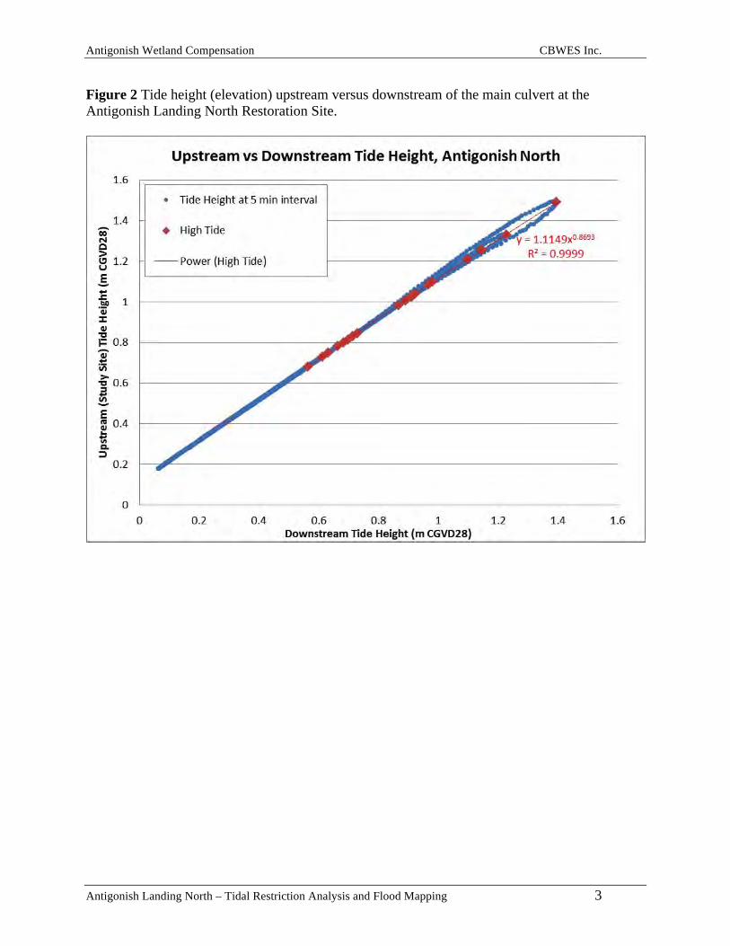
Dataloggers were installed upstream (within study site) and downstream (Rights River) of the main culvert (north end of Antigonish Landing North site) on 18 November 2010. Water level (elevation, mm) was recorded at five minute intervals between 18 November 2010 and 3 December 2010 in order to capture a spring and neap tide cycle. The maximum water level recorded during this period was ~ 1.5 m (Table 2). Water levels inside the study site were found to be, on average, 11.6 cm higher than downstream water levels. Part of this separation may be a result of survey error, however it is well within reasonable limits and not problematic in detecting a restriction. Comparison of the upstream and downstream water levels at high tide indicated both a spatial and temporal restriction of flow on recorded high tides greater than ~0.9 m (CGVD28). For this comparison the highest water level for each event (regardless of the timestamp) was selected. Not all high water levels were recorded at the same time in a given event due to a temporal delay in peak tide. Most tides exceeding ~0.9 m showed a delay in peak tide ranging from 5 to 25 minutes. The largest delay occurred on 19 November 2010, where peak tide was delayed by 25 minutes (water level within the study site continued to rise and peaked 25 minutes after the recorded peak downstream). The tide signals for the study site (upstream) and river (downstream), as well as associated statistics, are presented in Figure 1 and Table 1, respectively. The difference in tide height (upstream minus downstream tide height) is also provided in Figure 1 at each time step. The highest recorded tide (1.5 m), occurring on the 24 November 2010, and experienced a 15 minute delay in peak tide within the study site. A drop in the water level deficit on this date immediately prior to high tide and a rise immediately following, supports a delay in peak tide in the study area and a delay in ebb, with flows in the river rising and dropping more rapidly than in the study site. Peak tide was 9.7 cm higher in the study site than in the river, indicating that although there was a significant temporal delay, loss of tidal prism was probably not significant on the recorded tides. Although loss of tidal prism was not significant on the recorded tides, higher tides (greater than the recorded 1.5 m) which may be anticipated due to the Saros tidal cycle, sea level rise, and storm events (storm surges; increased freshwater input) may be significantly restricted. Best fit correlation (Figure 2) of upstream versus downstream high tide heights was used to predict the level of restriction under current crossing conditions as well as under unrestricted conditions, and is shown in Table 2. The degree of restriction was calculated up to a tide height of 2.1 m, based on the current highest recorded event plus the estimated 100 years of sea level rise at 70 cm/century, the minimum predicted rate for Nova Scotia1. It should be noted, however, that this approach is only valid to the elevation of the current trail (road) (~1.7 m). Any tidal event with a water elevation greater than 1.7 m would overtop (flood) the trail, making the culvert restriction irrelevant. A storm surge, which could add up to an additional meter in water elevation, would also lead to overtopping of the trial under both current and predicted conditions regardless of any
1 The State of Nova Scotia’s Coast: Technical Report. 1998. www.gov.ns.ca/coast/documents/report/Coastal-Tech-Report-Chapter7.pdf
Antigonish Wetland Compensation CBWES Inc.
Antigonish Landing North – Tidal Restriction Analysis and Flood Mapping 2
restoration efforts made at this site. Increasing the crossing size would, however significantly improve flushing of the system following a large flood event, thereby decreasing residency time for flood waters within the site, reduce flood risk of adjacent properties, and significantly improve fish passage and the transport of materials into and out of the restoration site. Figure 1 Tidal signal for the Antigonish Landing North Restoration (study) site and Right’s River, for the period of 18 November to 3 December 2010.
Table 1 Tidal signal statistics.
STAT DS (m) US (m) US/DS Deficit Min water level 0.06 0.06 0.003 Mean water level 0.61 0.73 0.116 Mean high tide 0.89 1.00 0.113 Max high tide 1.40 1.49 0.097 ST Dev 0.27 0.27 --
Antigonish Wetland Compensation CBWES Inc.
Antigonish Landing North – Tidal Restriction Analysis and Flood Mapping 3
Figure 2 Tide height (elevation) upstream versus downstream of the main culvert at the Antigonish Landing North Restoration Site.
Antigonish Wetland Compensation CBWES Inc.
Antigonish Landing North – Tidal Restriction Analysis and Flood Mapping 4
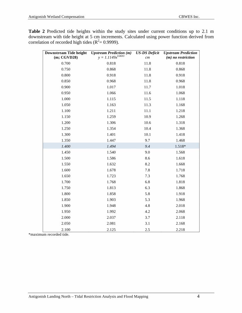
Table 2 Predicted tide heights within the study sites under current conditions up to 2.1 m downstream with tide height at 5 cm increments. Calculated using power function derived from correlation of recorded high tides (R2= 0.9999).
Downstream Tide height (m; CGVD28)
Upstream Prediction (m) y = 1.1149x0.8693
US-DS Deficit cm
Upstream Prediction (m) no restriction
0.700 0.818 11.8 0.818 0.750 0.868 11.8 0.868 0.800 0.918 11.8 0.918 0.850 0.968 11.8 0.968 0.900 1.017 11.7 1.018 0.950 1.066 11.6 1.068 1.000 1.115 11.5 1.118 1.050 1.163 11.3 1.168 1.100 1.211 11.1 1.218 1.150 1.259 10.9 1.268 1.200 1.306 10.6 1.318 1.250 1.354 10.4 1.368 1.300 1.401 10.1 1.418 1.350 1.447 9.7 1.468 1.400 1.494 9.4 1.518* 1.450 1.540 9.0 1.568 1.500 1.586 8.6 1.618 1.550 1.632 8.2 1.668 1.600 1.678 7.8 1.718 1.650 1.723 7.3 1.768 1.700 1.768 6.8 1.818 1.750 1.813 6.3 1.868 1.800 1.858 5.8 1.918 1.850 1.903 5.3 1.968 1.900 1.948 4.8 2.018 1.950 1.992 4.2 2.068 2.000 2.037 3.7 2.118 2.050 2.081 3.1 2.168 2.100 2.125 2.5 2.218
*maximum recorded tide.
Antigonish Wetland Compensation CBWES Inc.
Antigonish Landing North – Tidal Restriction Analysis and Flood Mapping 5
Part II: Antigonish North Site – Flood Map and Restoration Scenarios
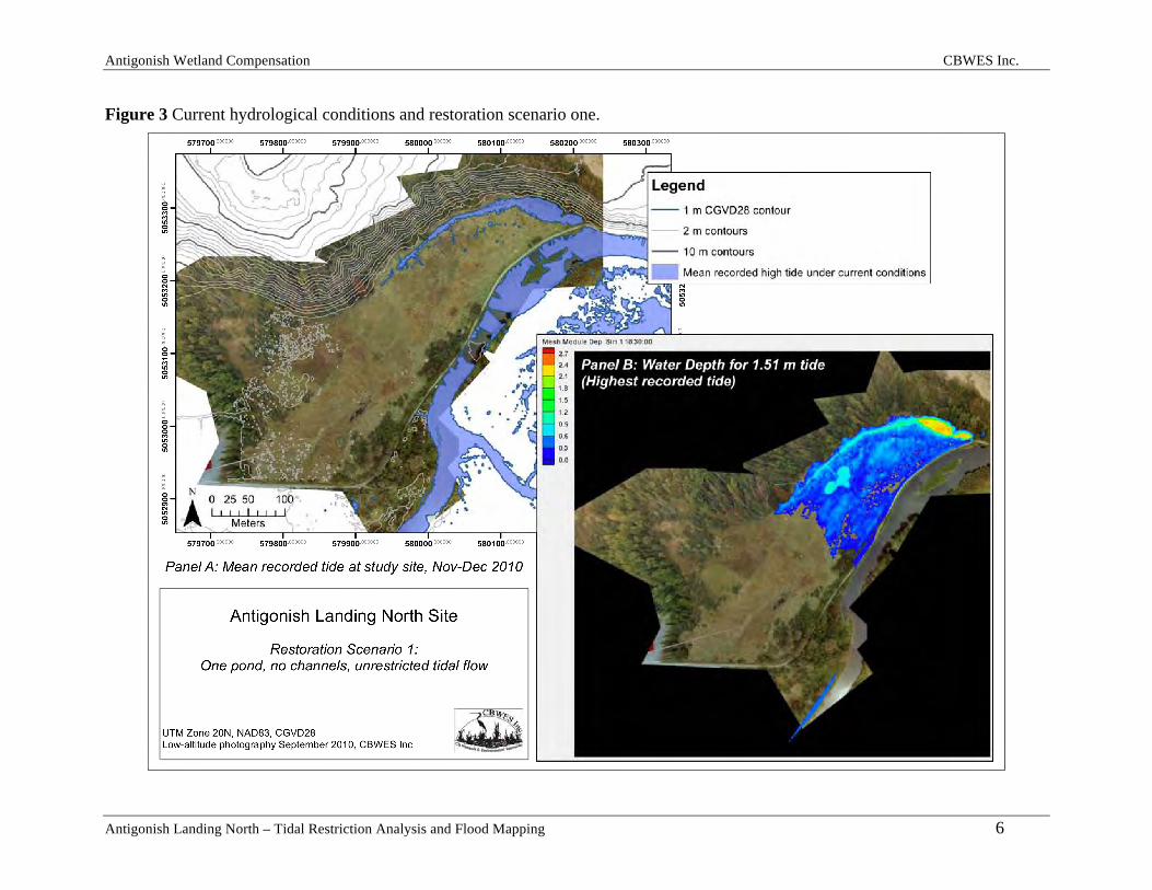
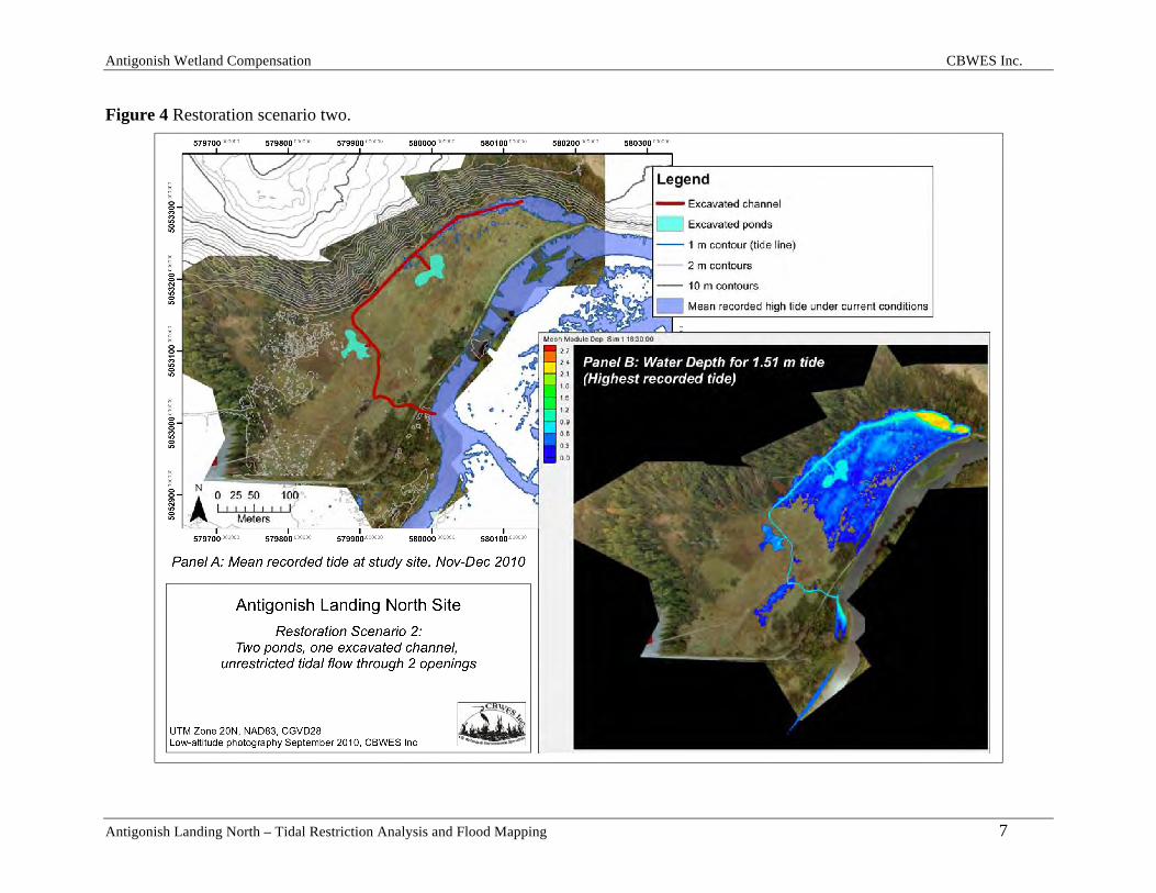
A flood map was produced for the Antigonish Landing North site based on the digital elevation model for the site and the recorded tides for the period of 18 November to 3 December 2010. Figure 3, Panel A shows the area flooded by the mean recorded tide (1.0 m) under current conditions (restrictive culvert). This mean tide level would be maintained even if a larger crossing was to be installed. The predicted flood pattern associated with the first restoration scenario – replacement of the north (primary) culvert with a larger crossing (minimum width of 3.5 m) in order to facilitate unrestricted tidal flow on the highest recorded tide (1.51 m) is depicted in Figure 3, Panel B. Hydrological conditions under a second restoration scenario involving unrestricted tidal flow through both the north and central (secondary) culverts (2 m opening), the creation of a tidal channel connecting the existing channel at the back of the site (base of hill) to the secondary culvert, and the excavation of two ponds on the marsh surface, is depicted in Figure 4, Panel B. Scenario two was produced using the recorded tide data and the full restoration design described in the Antigonish Wetland Compensation Proposal & Baseline Inventory Report. Restoration scenario two (Figure 4) is the preferred restoration option as it would result in the elimination of the tidal restriction; greater hydrological connectivity within the site and with the broader estuarine system; increased fish passage, habitat and access to the marsh surface; improved transport of materials, recharge and improved water quality in open water habitats within the site; and improve flushing of the site (reduced flood risk).
Antigonish Wetland Compensation CBWES Inc.
Antigonish Landing North – Tidal Restriction Analysis and Flood Mapping 6
Figure 3 Current hydrological conditions and restoration scenario one.
Antigonish Wetland Compensation CBWES Inc.
Antigonish Landing North – Tidal Restriction Analysis and Flood Mapping 7
Figure 4 Restoration scenario two.