Embed Size (px)
Citation preview

Nuclear waste? …not in my backyard!
Exploring the capabilities of GIS with online tools
Steve Carver & Andy Evans
School of Geography

Session outline
• Introduction
• Part 1. Concepts and technical details
• Part 2. Interactive session
• Part 3. Q&A

Introduction
• Teaching Geographical Information Systems (GIS)– Steep and long learning curve– Large classes– Access to teaching expertise and facilities?– Student skill base?
• Need for e-learning materials
Part 1: Web-based GIS
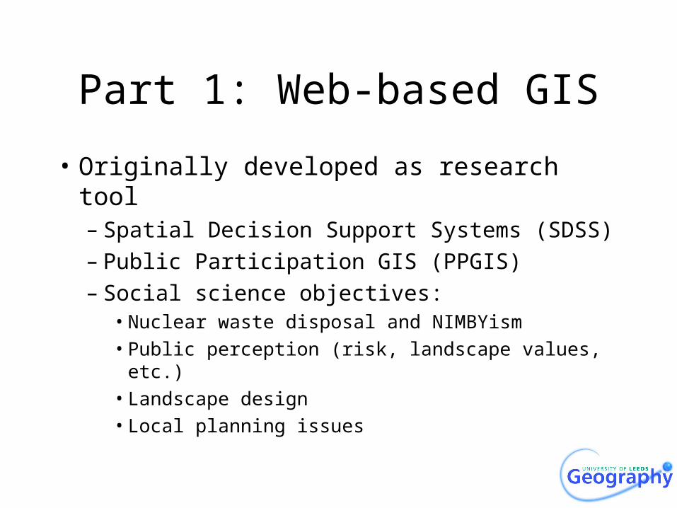
• Originally developed as research tool– Spatial Decision Support Systems (SDSS)– Public Participation GIS (PPGIS)– Social science objectives:
• Nuclear waste disposal and NIMBYism• Public perception (risk, landscape values, etc.)• Landscape design• Local planning issues
Where to bury nuclear waste?

Wilderness Britain?

Perceptions of crime

Woodland regeneration

Virtual Slaithwaite

Teaching GIS
• GIS as a paradigm in Geography– Need to teaching to increasing numbers of
students at UG and PG level– Emphasis on quantitative methods, digital
maps and spatial data– GIS software is complex, expensive and
frightening!– Availability of suitable CAL software?– Or the web?
Web-based teaching
• Safe learning environment?– Accessible to all– Non-software specific– Ease of use
• Focus on learning theory and concepts• Practice• Avoidance of technical issues• Low skills overhead
Technical detailThe systems are built as Applets.
These are relatively easy to build into a webpage.
Drop the Applet jar file and the data into your web directory.
The look and data are set up with a series of Parameter tags in the webpage code.
If you want to collect the data you’ll need a simple PERL script to do this.

Advice for online GIS
• Stick to less than 8 options at a time.
• Present data so that it is easy to get an overview, but allows for increasingly detailed exploration.– Tree structure– Walkthrough/overview pages with notes
• Be aware that the first time, people may just click through to get used to the system.

Further information
• http://www.ccg.leeds.ac.uk/democracy/
– Recommendations: “Twenty Recommendations for Online Democracy sites”
– Teaching: Carver, Evans, and Kingston: Journal of Geography in Higher Education
– Analysis: Evans, Kingston, and Carver Journal of Geographical Systems 6(2)p117

Part 2: Interactive session
• Use of “nuclear waste” GIS– Where to bury UK’s nuclear waste?– E-learning “nugget”– Explore, Experiment, Formulate
http://www.ccg.leeds.ac.uk/teaching/nuclearwaste/

Part 3: Q&A session
• Any questions?
• Suggestions for improvement?
• Future developments?
• Other applications?