Embed Size (px)
Citation preview

Elif Erkek 517121001 İTÜ
NUMERICAL MODELS
PRINCIPLES OF OCEANOGRAPHY
What is Oceanography?
The term "oceanography" is used exclusively for physical marine
science, i.e. the physics of the ocean.
The aim of oceanography is to provide a systematic understanding and
quantitative description of the ocean by means of the
relevant physical parameters (i.e. temperature, salinity,
density, pressure).

Numerical Modeling
In numerical models, the relevant system of
equations describing the ocean are numerically
discretized and approximated.
We have to be able to understand and possibly
predict some of changes is to use numerical models
to investigate the dynamics of atmosphere-ocean.

Numerical Modeling
Numerical models of ocean currents have many advantages.
They simulate flows in realistic ocean basins with a realistic sea floor.
They include the influence of viscosity and non-linear dynamics.
They can calculate possible future flows in the ocean. Perhaps, most
important, they interpolate between sparse observations of the ocean
produced by ships, drifters, and satellites

Numerical Models in Oceanography
Two main types of numerical models:
• Mechanistic models – simplified models that examine the mathematics
behind physical processes
• Simulation models – complex models that can be used to calculate the
realistic flow in the ocean
• Mechanistic models are easier to interpret and help to advance our
understanding of particular aspects of ocean circulation dynamics.
• On the other hand, simulation models allow direct comparison with
nature which is essential to prove that ocean models really do represent
nature

Numerical Models in Oceanography
What are some of the advantages and disadvantages of using numerical
models?
• Advantage:
The models can be used to simulate realistic flow and predict future
flow in the ocean
• Disadvantage:
The models cannot give completely accurate descriptions of the flow
in the ocean

Global Ocean Model
Several types of global models are widely used in oceanography which are providing impressive views of the global ocean circulation.
Geophysical Fluid Dynamics Laboratory Modular Ocean Model
Parallel Ocean Program Model
Hybrid Coordinate Ocean Model HYCOM
Regional Oceanic Modelling System ROMS
Climate Models
Global ocean models include:
1) Realistic coasts and bottom features
2) Heat and water fluxes through the surface
3) Eddy dynamics
4) Meridional- overturning circulation

Global Ocean Model
Geophysical Fluid Dynamics Laboratory Modular Ocean Model
The model is widely use
For climate studies
For studying the ocean’s circulation
The model uses
Momentum equations
Equation of state
Hydrostatic and Boussinesq
Approximations
Sea surface temperature

Global Ocean Model- Geophysical Fluid Dynamics
Laboratory Modular Ocean Model

Global Ocean Model
Parallel Ocean Program Model Produced by Smith and colleagues at Los Alamos National Laboratory
The model includes
Improved numerical algorithms
Realistic coasts, islands
Unsmoothed bottom features
General Circulation Model global grid
Parallel Ocean Program General Circulation Model
surface currents (speed of the water) in cm/sec

Global Ocean Model
Regional Oceanic Modeling System
A major aspect of ROMS current focus along these lines is the investigation of biogeochemical cycling and ecosystem population
dynamics along the U.S. West Coast
Top: SeaWIFS Ocean Color satellite image of Monterey Bay.
Bottom: Results of a ROMS simulation with the
US West Coast model. Shown are chlorophyll-a
concentrations in spring.
Climate Models
It is used for studies
Large-scale hydrographic structure
Climate dynamics
Water mass formation

Coastal Models
Many different numerical models for describing coastal currents, tides and storm surges. Coastal models can include
A free surface
Realistic coasts and bottom features
River runoff
Atmospheric forcing
Examples of different coastal models,
Princeton Ocean Model
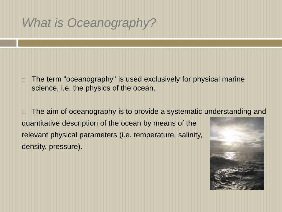
Dartmouth Gulf of Maine Model

Coastal Models
Princeton Ocean Model
The model has been used to
calculate the three-dimansional
distrbution of
Velocity
Salinity
Sea level
Turbulance
Surface height of hurricane Wilma

Coastal Models – Princeton Ocean Model
Coastal Models
Dartmouth Gulf of Maine Model
The model uses roughly 13.000 triangles
to cover the Gulf of Maine and nearby waters
of the north Atlantic
The model has a simplified equation of
state and it uses the hydrostatic and
Boussinesq assumptions.
Top: Topographic map of the Gulf of Maine showing important features. Inset: Triangular grid used to
compute flow in the gulf.

Coupled Ocean and Atmosphere Models
A coupled model is different.
Changes in the atmosphere do
cause changes in the ocean.
Changes in the ocean part of the
model can cause changes in the
atmosphere part. So if lots of carbon
dioxide moved from the atmosphere
to the ocean, the ocean might get
"full" of CO2. It might not be able to
hold any more. Or it might take in
more CO2 very slowly.

Coupled Ocean and Atmosphere Models
The most important use of the models has been to study
How earth’s climate might respond to a doubling of carbondioxide in the
atmosphere
El Nino and the meridional overturning circulation
Many coupled ocean and atmosphere models have been developed
Climate System Model
Princeton Coupled Model
Hadley Center Model
Some include only physical processes in the ocean, atmosphere and the ice-
covered polar seas
Others add the influence of land and biological activity in the ocean

Result
Why don’t scientist always use coupled models instead of uncoupled
model?
Coupled models are very very complicated. It takes a lot of work to make sure
the answers from them are right. It takes a long time to run, even on fast
computers.
Numerical models is very important to recognize that a model is an
approximation of the real world. Good understanding and prediction of the
real world.