Embed Size (px)
Citation preview

1 | P a g e
TIDAL WETLANDS GUIDANCE
DOCUMENT Living Shoreline Techniques in the Marine District
of New York State
November 22, 2017
Planting marsh grasses along a "living shoreline" on the Shinnecock Reservation, Southampton NY on
Shinnecock Bay in Suffolk County , NY. This rock sill and native vegetation can protect shores from erosion and
wave damage and create habitat for wildlife.
Photo credit: Cornell Cooperative Extension, Suffolk County

2 | P a g e
A. Definition ......................................................................................................................................... 7
B. Types of Living Shoreline Techniques ....................................................................................... 8
A. Regulatory Standards for Permit Issuance ............................................................................. 10
B. Evaluation of Standards for Permit Issuance .......................................................................... 12
A. Erosive Forces: ............................................................................................................................ 17
2. Boat Traffic ................................................................................................................................ 18
4. Surface Water Runoff .............................................................................................................. 18
5. Erosion Rate ............................................................................................................................. 18
B. Habitat .......................................................................................................................................... 19
C. Other Physical Shoreline information ...................................................................................... 19
Maintenance and Monitoring Reports ........................................................................................... 22
A. Short Term Construction Impact Mitigation ............................................................................. 23
B. Additional Regulations ................................................................................................................ 23
C. Clean Fill Only ............................................................................................................................. 24
D. Contiguous Property Owners .................................................................................................... 25
E. Hazardous Material Remediation ............................................................................................. 25
F. Timing Restrictions...................................................................................................................... 25
A. Sources Referenced in this Guidance Document .................................................................. 26
Table of Contents

3 | P a g e
B. Sources of Information on Climate Change and Sea Level Rise ........................................ 28
C. Sources of Information on Nature-based Shorelines............................................................. 29
*cited in the guidance ...................................................................................................................... 30
A. Common Terms Defined in this Guidance .............................................................................. 31
B. Terms Defined in Other Sources .............................................................................................. 33
Basic Drawing Requirements ......................................................................................................... 36
Site Plans: ......................................................................................................................................... 36
Crossviews: ....................................................................................................................................... 37
Additional Drawing Details Required for Specific Activities: ...................................................... 37
Site Plans: ......................................................................................................................................... 37
Crossviews: ....................................................................................................................................... 38
Living Shoreline Treatments or Other Erosion Protection Structures ...................................... 38
Site Plans: ......................................................................................................................................... 38
Cross views: ...................................................................................................................................... 38
4 | P a g e
Summary
The intent of this document is to provide guidance on the issuance of permits for living
shorelines techniques in the Marine and Coastal District Waters of New York (the
Marine District) and it answers the recommendations of the NY 2100 Commission report
to encourage the use of green or natural infrastructure.
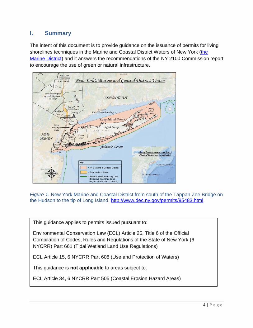
Figure 1. New York Marine and Coastal District from south of the Tappan Zee Bridge on the Hudson to the tip of Long Island. http://www.dec.ny.gov/permits/95483.html.
This guidance applies to permits issued pursuant to:
Environmental Conservation Law (ECL) Article 25, Title 6 of the Official
Compilation of Codes, Rules and Regulations of the State of New York (6
NYCRR) Part 661 (Tidal Wetland Land Use Regulations)
ECL Article 15, 6 NYCRR Part 608 (Use and Protection of Waters)
This guidance is not applicable to areas subject to:
ECL Article 34, 6 NYCRR Part 505 (Coastal Erosion Hazard Areas)

5 | P a g e
Purpose and Scope
This purpose of this guidance is to: (A) to encourage appropriate use of living
shorelines in place of hardened approaches for erosion control, because living
shorelines offer greater habitat and ecological value than hardened shorelines and
revetments (Figure 2), (B) to encourage, where appropriate, modification of existing
shoreline erosion control structures into living shorelines, and (C) to promote a
consistent approach for permit application evaluations for living shoreline techniques.
This guidance is intended for a wide audience: state permitting staff, design
professionals, and property owners. This guidance applies to the following use-
categories in the Tidal Wetland Land Use Regulations and similar, or related, activities
that are also regulated under ECL Article 15 and 6 NYCRR Part 608 (Use and
Protection of Waters, Excavation and Placement of Fill in Navigable Waters):
Establishing plantings (6 NYCRR § 661.5(b)(9));
In-kind and in-place replacement of existing functional bulkheads and similar
structures (6 NYCRR § 661.5(b)(22));
Substantial restoration or reconstruction of existing functional structures (6
NYCRR § 661.5(b)(24));
Expansion or substantial modification of existing functional facilities and
structures (6 NYCRR § 661.5(b)(25));
Construction of groins, bulkheads, and other shoreline stabilization structures (6
NYCRR § 661.5(b)(29)); and,
Filling (6 NYCRR § 661.5(b)(30)).
The guidance presented here pertains to living shoreline installations that are generally
conducive to low-moderate energy, sheltered areas of the Marine District (Figure 3).
This guidance does not apply to large habitat restoration projects or CEHA jurisdictional
areas (large coastal erosion protection projects).
Figure 2. Sheltered creek (low energy area) DEC GIS 2013 images.

6 | P a g e
This guidance applies to living shoreline techniques ranging from permit-required,
generally compatible activities (GCp) (for example, in-water marsh plantings on an
eroded shoreline) through activities that are permit-required, presumptively incompatible
(PIp) (for example, in-water filling). Projects may be located on public or private
properties. Section IV, Permitting Requirements and Standards, provides guidance to
determine how to evaluate your project as per permit standards.
Introduction to Living Shoreline Techniques and Benefits
New York acknowledges national and state trends that emphasize the importance of
and the value of natural and nature-based features (NNBF) such as living shorelines to
reduce risk from flooding and erosion. Living shorelines also provide public benefits
including supporting fisheries, improving water quality, and adaptability over time to
changing conditions. Appropriate NNBF integrate well with regional ecosystems.
Figure 3. Benefits of Living Shorelines. Image credit: NOAA.

7 | P a g e
There is a preference for the shoreline to remain in its natural state as much as is
possible. Living shoreline projects that mimics the natural environment are preferred
over hybrid options that utilize structural components. Projects should try and emulate
the natural coastal process of the area before options with structural components are
considered.
New York State (NYS) Department of Environmental Conservation (DEC) prefers the
use of ecologically sustainable techniques over hardening techniques when erosion
control projects are necessary in the Marine District. The benefits living shoreline
techniques can provide include
Improving water quality through filtering nutrients and other pollutants;
Creating habitats for fish, birds and other marine resources;
Providing attractive and natural appearance and offer public access
opportunities;
Providing for erosion control – reducing wave energy impacts;
Adaptability and resilience to erosive forces and sea level rise in comparison to
hardened shorelines;
Maintaining natural shoreline dynamics and sand movement and
Economy, as they often are less costly than traditional shoreline stabilization
methods such as bulkheads and revetments.
A. Definition
For the purposes of this guidance, the Division of Marine Resources (the
Division), Bureau of Marine Habitat defines living shoreline techniques as follows:
Shoreline techniques that incorporate natural living features alone or in
combination with structural components such as rock, wood, fiber rolls,
bagged shell, and concrete shellfish substrate.1 This combination is also
called hybrid. To be considered a living shoreline the techniques shall:
• Control or reduce shoreline erosion while maintaining benefits
comparable to the natural shoreline such as, but not limited to,
allowing for natural sediment movement;
• Use the minimum amount of structural components necessary for
hybrid techniques to obtain project goals;
1 Concrete shellfish substrate includes trademarked manufactured products such as reef balls, oyster castles or reef blocks.

8 | P a g e
• Improve, restore, or maintain the connection between the upland
and water habitats; and
• Incorporate habitat enhancement and natural elements, frequently
includes native re-vegetation or establishment of new vegetation
that is consistent with a natural shoreline typical of the site location.
B. Types of Living Shoreline Techniques
There is a spectrum of shoreline erosion protection techniques, ranging from
plantings only to the use of hard material such as rock. All techniques have in
common that they can accomplish various shoreline risk reduction goals, such as
soil stabilization or wave energy attenuation. At the same time, these techniques
have varying impacts on the ecological community and natural processes.
Erosion management techniques can be used appropriately in combination with
each other to manage risk, provide diversity, accommodate different uses, and
conserve essential natural resources and processes. The features of a living
shoreline project should include provisions for maintenance or improvement of
connectivity between terrestrial and marine environments; use and maintenance
of natural sediment transport pathways and quantities; utilization of shallow
slopes while minimizing footprint as much as practicable; diversity in the plan
view (i.e., not a straight, homogenous shoreline); encouraging use of native plant
communities; allowing for filtration of stormwater and other natural processes;
and utilization of the minimal amount of structural materials and minimizing the
project footprint.
The following are examples of living shoreline techniques best suited for low to
moderate wave energy environments that may be viable in the Marine District
(see page 15 for wave energy characteristics). Additional and other available
techniques may be considered should they meet the definition and goals of living
shorelines. A coastal engineer, coastal geologist, landscape architect, or
restoration scientist can provide designs which combine these techniques to
accomplish the objectives of the shoreline stabilization project.
• Beach nourishment /sand replenishment to restore coastal processes
• Bank stabilization with vegetation
• Edging or toe protection
• Vegetated slope with additional structural protection
• Low profile sill with vegetation
PLEASE NOTE: This is not an exhaustive list, and the proposal of any of these
techniques is not guarantee of a permit approval. An analysis may be necessary to
9 | P a g e
determine stability of any material, combination of materials or layout at a particular site.
Appendix D, Descriptions of Living Shoreline Techniques, provides more information on
some of these examples of shoreline stabilization techniques and includes illustrations.
Permitting Requirements and Standards
Shoreline stabilization structures within the Marine District require various state permits.
See Table 1 below.
Permit Program Rules & Regulations
Description
Article 25 – Tidal Wetlands 6 NYCRR § 661 Permit required for certain activities in tidally-influenced wetlands and their regulated adjacent areas. Regulated wetlands are identified on Tidal Wetland Regulatory Maps.
Article 15 – Excavation & Fill in Navigable Waters; and Water Quality Certification“
6 NYCRR §§ 608.5; 608.9
Permit required for excavation and fill below MHW in all lakes, rivers, streams, and other bodies of water in the state that are navigable in fact, including wetlands adjacent and contiguous to navigable waters of the state; construction or operation of facilities that may result in a discharge into navigable waters.
Coastal Zone Consistency 15 CFR Part 930 Subpart D and 19 NYCRR Part 600;
Consistency determination and review conducted by New York State Department of State (DOS) for actions, including permit review, in a coastal area; State agency consistency review (done by all other NYS agencies when undertaking an action in the Coastal Area)
New York State Office of General Services (NYSOGS)
Public land law, Article 6
Title to the bed of numerous bodies of water is held in trust for the people of the State of New York. Structures, including fill, located in, on, or above state-owned lands under water may require authorization from the state.
Other state permits
Stream Disturbance: There are some areas of the marine district where waterbodies
are also subject to regulation under Article 15, Title 5, Protection of Waters and 6
NYCRR Part 608.2, Disturbance of protected streams. This applies to streams or

10 | P a g e
ponds of less than 10 acres in size which have the following classifications or
standards: AA, AA(t), A, A(t), B, B(t), or C(t). Jurisdiction extends to both the bed and
banks, which can extend as much as 50 feet from the stream.
Wild, Scenic and Recreational Rivers Systems: There are a few areas of the marine
district that are also subject to regulation pursuant to Article 15, Title 27 and 6 NYCRR
666 as Wild, Scenic, or Recreational River areas. A list of the designated river areas is
available on the DEC website at http://www.dec.ny.gov/permits/32739.html. The
regulated river area may extend well landward of the waterbody. If your site is near a
designated section, contact your regional DEC office for more information.
DEC strongly urges applicants unfamiliar with DEC permitting procedures to request a
pre-application conference, in order to obtain preliminary answers to questions about
wetland and adjacent area boundaries, application procedures, standards for permit
issuance, and other potential regulations and compliance issues such as historic
preservation, endangered species, or hazardous waste disposal sites. For information
on the tidal wetland application procedures, visit the DEC website at
http://www.dec.ny.gov/permits/6357.html. As discussed below, the procedures for tidal
wetlands applications are inclusive of those for Use and Protection of Waters and Water
Quality Certification.
If an applicant requires a pre-application conference, a preliminary project plan and a
written request for a pre-application conference should be submitted to the appropriate
Regional Permit Administrator. A list of regional contacts by county can be found at
http://www.dec.ny.gov/about/39381.html.
Please see section VIII. B. 5 for other governmental permit information.
A. Regulatory Standards for Permit Issuance
All projects must meet the standards for permit issuance for each permit
required. The standards for permit issuance can be found at:
Tidal Wetlands, 6 NYCRR § 661.9
Use & Protection of Waters, 6 NYCRR § 608.8
Water Quality Certifications, 6 NYCRR § 608.9
Applicants should contact the applicable DEC Regional Division of Environmental
Permits office before beginning the application process.
11 | P a g e
The applicable standards for permit issuance for Parts 608 and 661 overlap and
can be summarized by the four points below. Before DEC will issue or modify a
permit, it must determine that the proposal is not contrary to public interest and
meets the following requirements (the list below has been paraphrased):
The proposal is compatible with the policy of the Tidal Wetlands Act
(Article 25 of the ECL) to preserve and protect tidal wetlands and to
prevent their degradation (6 NYCRR § 661.9(b)(1)(i)); that work in the
adjacent area will not have an undue adverse impact on the present or
potential value of any adjacent or nearby tidal wetland (6 NYCRR §
661.9(c)(3)); and that the project will not cause unreasonable,
uncontrolled, or unnecessary damage to the natural resources of the
state (6 NYCRR § 608.8(c)).
The proposal is compatible with and will not endanger the public
health, safety, and/or welfare (6 NYCRR §§ 661.9(b)(1)(ii), 661.9(c)(1),
and 608.8(b)).
The proposal for work in tidal wetlands and below mean high water is
reasonable and necessary (6 NYCRR §§ 608.8(a) and 661.9(b)(1)(iii)).
The proposal complies with the use guidelines contained in 6 NYCRR
§ 661.5. If a proposed regulated activity is a presumptively
incompatible use under this section, the applicant must overcome the
presumption and demonstrate that the proposed activity will be
compatible with the area involved and with the preservation, protection,
and enhancement of the present and potential values of tidal wetlands
(6 NYCRR §§ 661.9(b)(1)(v) and 661.9(c)(4)).

12 | P a g e
B. Evaluation of Standards for Permit Issuance
Generally, the decision to grant a permit for a living shoreline project will take into
account the suitability of a project for the overall conditions of the site (e.g., fetch,
soil type, erosion, adjacent shoreline conditions, and habitat). Living shoreline
projects must be designed and constructed to avoid impacts to ecological
functions, critical area resources (such as eelgrass beds and finfish habitats,
habitats for state and federally listed threatened and endangered species and
species of greatest conservation need), processes (such as currents and
sediment processes), and recreational or other human use of the area or, if that
is not possible, to minimize and mitigate unavoidable impacts. Preferably, living
(nature based) shoreline projects should be constructed and designed to provide
for necessary erosion control while enhancing the area involved through
improvement of water quality, creation of habitat, adaptability to sea level rise
and promotion of natural sand movement. Benefits are discussed in Section III
above. Guidelines are provided below to assist permit applicants and
Department staff in evaluating the compatibility of a proposed project with on-site
conditions and to facilitate consistent determinations in the issuance of permits.
1. Undue Adverse Impact
To determine whether or not the project will have an “undue adverse
impact on the present or potential value of the affected” tidal wetlands,
adjacent areas, and/or other resources of the state (6 NYCRR §§
608.8(c), 661.9(b)(1)(i), and 661.9(c)(3)), the applicant must provide an
evaluation of the resources that might be affected by the proposed project
as follows:
a. Indicating the amount and location of upland or wetland area
affected, including any filling or excavation;
b. Defining the impact to any areas below the apparent high water line
or in tidal wetlands and indicating how that impact will be avoided
or minimized. In addition, it must be demonstrated in which way(s)
the project will enhance the current and potential function as related
to tidal wetland values as defined in the regulations (6 NYCRR §
661.2) and in Appendix A;
c. Evaluating how the project may affect wildlife (e.g., birds, fish,
invertebrate community, species of greatest conservation need),
including the potential for taking of threatened or endangered
species requiring a permit pursuant to ECL Article 11, Title 5 and 6
13 | P a g e
NYCRR Part 182, and or any beneficial effect the project may have
on wildlife; and
d. Evaluating how the project may affect the sediment processes,
including, but not limited to, sediment transport pathways, sediment
supply, and sediment type.
2. Public Health and Welfare
A proposal must not have negative impacts on public health and/or
welfare (6 NYCRR §§ 608.8(b), 661.9(b)(1)(ii), and 661.9(c)(1)). An
applicant must also include an explanation of how the project will or will
not affect adjacent landowners. The explanation should include the
following:
a. An assessment of the potential erosion or sediment deposition to
the surrounding area resulting from the project. If it is determined
that the project has the potential to cause erosion to surrounding
areas, the potential impact and ways to minimize and mitigate that
erosion must be detailed;
b. Documentation of permission from any affected property owners if
the installation will extend beyond property lines (adjacent property
owners may include municipalities and the NYSOGS if work is
proposed below the apparent high water line);
c. An assessment demonstrating that the living shoreline project does
not substantially interfere with navigation (eg. extending too far into
waterway), recreational access (eg. blocking usage of a public
waterfront, or other existing uses of the area involved; and
d. Other considerations, as outlined in Section VIII, Other
Considerations, Part B, Additional Regulations, such as information
about utilizing shellfish in a living shoreline project.
3. Reasonable and Necessary
The proponent of a regulated activity in a wetland must demonstrate that
the proposal is reasonable and necessary (6 NYCRR §§ 608.8(a) and
661.9(b)(1)(iii)).
Typically, shoreline structures are installed to protect shorelines from
erosion and to some extent, for flood protection. Measures to address
erosion and flood protection generally will only meet the reasonable and

14 | P a g e
necessary criteria if there is infrastructure, development, or habitat to
protect and no other reasonable option is available.
a. Analysis should consider the degree to which the activity requires
water access or is water dependent, consider alternate sites for non
water dependent development that are less vulnerable to erosion,
and the feasibility of relocating existing development to a site
removed from the eroding area.
b. An applicant shall assess the causes and rates of erosion on the
site, the jeopardy to existing uses, and demonstrate a need for the
proposed treatment, taking into account reasonable alternatives.
Erosion is a natural process; it is the wearing away of soil by forces
such as wind, water, and ice. Natural erosion is necessary to
maintain adjacent beaches and landforms, and the biological
community is adapted to erosive and storm events. The prevention
of erosion can have negative effects on adjacent areas. Erosion
along a shore can be caused by animals, currents (downstream or
tidal), wind driven waves, vessel wakes, upland runoff, ice, floating
debris, construction of vertical structures, or placement of
structures such as bulkheads, jetties, and groins. Sea-level rise
causes shoreline recession, which is sometimes interpreted as
natural erosion.
Erosion on a shore can also be caused by animals, surface water
runoff, wind, ice, and gravity, which causes the sediment to move
downslope. Humans can exacerbate erosion by foot and vehicle
traffic, through placement of impervious surfaces in the upland and
through direct excavation or other disturbance of soil or vegetation.
The applicant is encouraged to address upland stormwater runoff
as this will reduce impacts to the adjacent wetland.
It is important to estimate the rate of erosion (amount of sediment
lost over time, measured in inches or feet per year). The rate of
erosion can be most readily estimated through photographic
evidence. Sources of photography include historical aerial or
satellite imagery (www.historicaerials.com and Google Earth) as
well as dated site photos showing gradual root exposure or loss of
land based on the distance to a fixed object.
15 | P a g e
c. The applicant shall provide an alternatives analysis. Alternatives to
consider include:
doing nothing, the “no action alternative”;
retreating, moving manmade structures landward;
proper siting of newly proposed upland structures
removing structures entirely and allowing the area to return
to natural conditions or restoring a shoreline’s natural
features; and
evaluating reasonable alternate shoreline treatments.
Provide a discussion of why the preferred alternative was chosen
over others. The alternatives analysis is used to understand the
trade-offs: it must provide a sufficient level of technical analysis
necessary (i.e., costs, benefits, detriments) to support the preferred
alternative. In regards to shoreline treatments options, the
appropriateness of the upland use that the proposed erosion
control structure would protect should be considered, including
whether the upland use will be viable under projected future
conditions and storms, see Section V, Sea-Level Rise and Climate
Change. DEC prefers the use of ecologically sustainable
techniques over hardening techniques when erosion control
projects are necessary in the Marine District.
4. Use Categories
A proposed activity must also comply with the use guidelines set forth in 6
NYCRR § 661.5.
Under 6 NYCRR §§ 661.9(b) [tidal wetlands] and (c) [adjacent areas], the
designation of an activity as presumptively incompatible places (Plp), the
burden on the applicant to demonstrate that the project is, in fact,
compatible and the application will need a more developed analysis of
potential impacts. The proponent of an activity with this designation will
need to show that the project will not have undue adverse impacts on
present or potential values of a wetland. The PIp designation assumes
that these activities will have some negative effect on natural resources.
Therefore, showing that the project will improve a degraded shoreline and
provide environmental benefit to the wetland and upland area involved is
key to overcoming this presumption. Proposals to enhance existing
16 | P a g e
wetland benefits can be considered in making a decision whether or not to
grant a permit.
Some examples of the benefits provided by tidal wetlands and adjacent
areas that can be preserved or enhanced through a living shoreline in
comparison to standard structural erosion control techniques are:
a. Providing an enhanced habitat for a variety of native species
(including forage, nursery, and refuge areas);
b. Providing for energy dissipation; fostering natural sediment process
characteristic of the site;
c. Maintaining the connection between water and upland for fish,
wildlife and other natural processes such as nutrient cycling,
and water quality protection; and
d. Providing for the potential to create space for wetland expansion.
Sea-Level Rise and Climate Change
In 2010, DEC Commissioner’s Policy CP-49, “Climate Change and DEC Action” was
enacted, which requires that DEC consider Climate Change in all aspects of its
activities, including permit approvals. New York State’s 2100 Commission Report,
Recommendations to Improve the Strength and Resilience of the Empire State’s
Infrastructure (2013), was written after the devastation of Hurricane Irene, Tropical
Storm Lee, and Superstorm Sandy, and recommends using natural resilience measures
such as living shorelines as a key strategy to reducing future risk. The “Community Risk
and Resiliency Act” (CRRA) of 2014 will advance these recommendations even further.
See Appendix C, CRRA and Sea-Level Rise Projections, for additional information on
CRRA.
When designing a living shoreline, applicants should consider factors relating to climate
change and sea-level rise by recognizing that conditions are likely to change over the
life-span of the structure and design accordingly. Living shorelines are typically more
adaptable to sea level rise than traditional hardened shorelines (eg. marshes that may
accrete in relation to rising seas, or the addition of extra stone to raise the height of a
marsh sill). Issues to consider include:
higher mean and spring tide levels,
higher storm surges and larger areas of inundation,
extreme precipitation rates and greater stormwater runoff,
17 | P a g e
greater frequency and intensity of storms,
wetland migration inland,
changes in salinity and migration of the salt wedge, and
permanent inundation of coastal properties.
The Department has established science based projections of sea-level rise in three specified geographic regions over various time intervals (6 NYCRR Part 490, Projected Sea-level Rise).
Sea-level rise and flooding must be considered for major projects under the affected
UPA permit programs, including Article 25. An applicant can also use municipal or
other established sea-level rise projections that may be more cautionary.
See Appendix C, CRRA and Sea-Level Rise Projections.
Proper Siting
An applicant must demonstrate that the proposed living shoreline techniques chosen
after the above analysis, is adequate for the area and appropriately designed to
consider wave action and other site characteristics. Living shorelines are most
appropriate for low to moderate wave energy environments. See Appendix D,
Descriptions of Living Shoreline Techniques, for examples of demonstration projects.
The characteristics of the location of the potential living shoreline are important to the
design and subsequent success of the living shoreline techniques. Factors for the
design may include the following:
A. Erosive Forces:
1. Wave Characteristics – It is important to understand the wave
characteristics affecting the project site, as shorelines are shaped and
modified by wave processes. Waves are dependent on shore slope,
bottom friction, angle, tides and ultimately on meteorological conditions
which control wave formation and interaction. The size of the waves is
the result of energy transfer from wind, the fetch or distance over which
the wind blows, and the duration of the blowing wind. Waves are also
affected by water depth. Below are general characteristics associated
with differing wave energy environments:
a. Low energy: Limited fetch in a sheltered, shallow, or small
waterbody (estuary, river, bay) i.e., wave height is less than 2 feet.
b. Medium energy: A range that combines elements of low and high
energy (shallow water with a large fetch or partially sheltered) i.e.,
wave height ranges from 2 to 5 feet.

18 | P a g e
c. High energy: Large fetch, deep water (open ocean) i.e., wave
height exceeds 5 feet. This wave environment is not appropriate for
the living shoreline projects addressed under this guidance.
It is important to design nature-based features in such a way that they
will establish and/or re-establish natural processes and become as
self-sustaining as possible. It is up to the applicant to make sure the
living shoreline option chosen will work in the environment on site.
2. Boat Traffic – A boat travelling through the water generates a wake or
waves that can cause erosion. It is beneficial to understand the
amount of boat traffic and wake-generating wave characteristics in the
area of a project. Boat wakes are common in many water bodies.
3. Ice – In bodies of water that freeze, ice can cause scouring to river
edges, the inshore shallows, and surfaces it contacts. Tidal currents
break solid ice into large floes, which slowly move downstream. The
ice itself can push sediment in response to wind and water forces. It is
beneficial to understand average thickness, duration, areal coverage,
and how these factors impact affect a site.
4. Surface Water Runoff – When rain or snow falls to the ground, it
starts moving and some seeps into the ground where it may replenish
groundwater. Most flows downhill as runoff. Runoff is extremely
important; not only does it keep rivers and lakes full of water, but it also
can change the landscape if the runoff is strong enough and the
surface material unstable enough to cause erosion. It is beneficial to
understand how surface water may affect a site for any proposal and
how runoff and groundwater seepage should to be treated so as not to
exacerbate erosion of the site.
5. Erosion Rate – Distance of shoreline, area, or volume of sediment lost
and deposited, and sediment transport patterns over time.
Understanding the rate of erosion and sediment movement is essential
for designing a solution. For example, the use of temporary protection
until plants are established, or choosing plantings alone versus a
hybrid stabilization solution will depend on erosion rate as well as other
factors.
19 | P a g e
B. Habitat
1. Habitat – Type of plant and animal life occurring on or near the site
that may be affected by the proposal.
2. Water Condition – Certain living shoreline components depend upon
water quality, including, dissolved oxygen concentrations, water
temperature, salinity, and turbidity. These conditions may be important
to survival of certain aspects of a chosen living shoreline.
3. Sunlight Exposure – The direction and the duration of time at which
sunlight falls on the landscape. Sunlight exposure over both land and
water is important for plant selection, to aid in determining the use of
sun-or shade-loving plants.
C. Other Physical Shoreline information
1. Tidal Range – The vertical difference between high tide and low tide.
This is important for grading, determining height of sills or other
preferred living shoreline types, and selection of plants and/or shellfish.
a. Mean Lower Low Water - the average of the lower low water
height of each tidal day.
b. Mean Low Water - the average of all the low water heights;
c. Mean High Water - the average of all the high water heights;
d. Mean Tide Level - the arithmetic mean of mean high water and
mean low water;
e. Mean Higher High Water - the average of the higher high water
height of each tidal day.
2. Tidal Datums – Tidal datums are used as references to measure local
water levels observed over the National Tidal Datum Epoch. These
designations are important for grading, determining height of sills or
other preferred living shoreline types, and selection of plants and/or
shellfish.
3. Sea-Level Rise Projections – Scientists project sea levels along New
York's coastlines and estuaries will be 18 to 50 inches higher by the
year 2100 than they are today, though a rise as much as 75 inches
could occur. As per Section V above, the design of a living shoreline
technique should consider sea-level rise because the rise of the sea
will change the conditions of the shoreline. In Figure 3, (p.6), projected
sea-level rise water levels are incorporated into the project’s upper

20 | P a g e
slope. As well as appropriate plant species adaptive to impacts of sea
level rise.
4. Any Existing Shoreline Stabilization and its Condition – The types
of shoreline stabilization and conditions of neighboring properties are
necessary to understand sediment deposition and erosion
patterns/rates and how they affect any project proposal and vice versa.
5. Shoreline Slope – The level at which the ground at the project site
tends downward towards the water, expressed as the horizontal
distance divided by the vertical distance, for example 3 divided by 1,
3/1, or 3:1. This is also important for grading, determining height of sills
or other preferred living shoreline types, and selection of plants and
shellfish. Sharp breaks in slope should be noted. The land area from
approximately the upland area to mean lower low water. Often the
shoreline is broken into sections categorized as upland slope (above
MHW), shoreline slope (between MHW and MLW) and offshore slope
(below MLW).
Figure 4. Shoreline Slope. Image credit: K. Giuliano.
6. Soil Bearing Capacity – The ability of soils to hold up to the weight of
overlying structural elements such as stone or concrete without
settling.
7. Soil and Sediment Types – The different types and sizes of particles
of soil/sediment in a particular site location. This is important for
understanding sediment mobilization potential and choosing
vegetation, as soil/sediment type will influence stability, rate of growth
and root penetration. Matching appropriate soil and sediment grain
21 | P a g e
size with proposed measures is important for successful living
shoreline types.
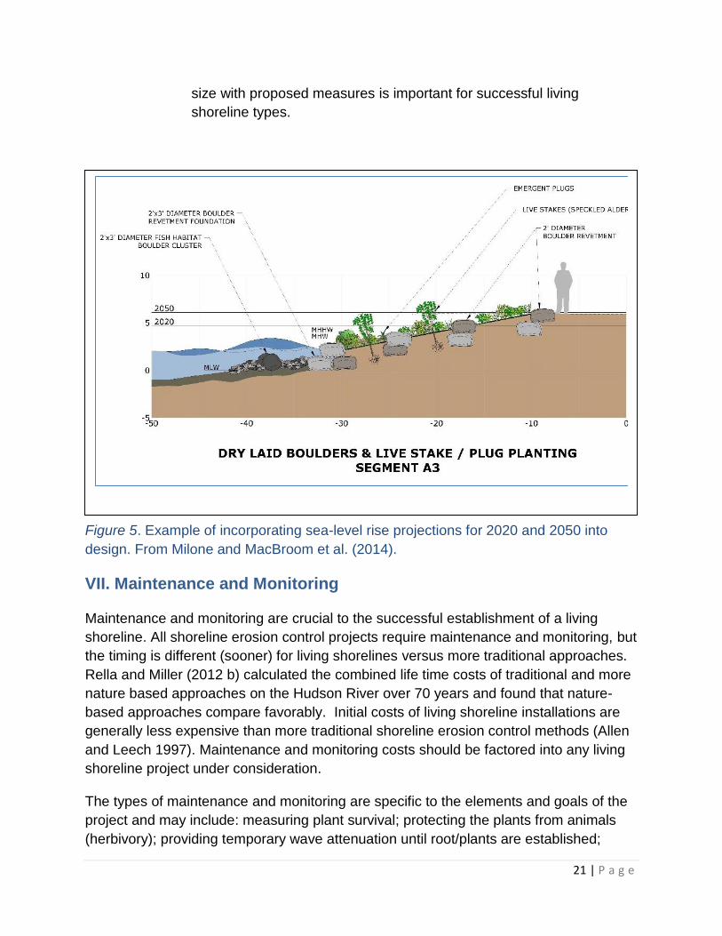
Figure 5. Example of incorporating sea-level rise projections for 2020 and 2050 into
design. From Milone and MacBroom et al. (2014).
VII. Maintenance and Monitoring
Maintenance and monitoring are crucial to the successful establishment of a living
shoreline. All shoreline erosion control projects require maintenance and monitoring, but
the timing is different (sooner) for living shorelines versus more traditional approaches.
Rella and Miller (2012 b) calculated the combined life time costs of traditional and more
nature based approaches on the Hudson River over 70 years and found that nature-
based approaches compare favorably. Initial costs of living shoreline installations are
generally less expensive than more traditional shoreline erosion control methods (Allen
and Leech 1997). Maintenance and monitoring costs should be factored into any living
shoreline project under consideration.
The types of maintenance and monitoring are specific to the elements and goals of the
project and may include: measuring plant survival; protecting the plants from animals
(herbivory); providing temporary wave attenuation until root/plants are established;

22 | P a g e
removal of invasive species and debris; replacing or removing sediment; measuring
shellfish productivity for certain projects; measuring erosion and accretion patterns; and
assuring that the organic and structural materials stay in place (e.g., replacing stakes,
moving fiber rolls, or loose rock). Ordinary maintenance and repair (not involving
expansion or substantial restoration and reconstruction or modification of existing and
functional structures) does not require a tidal wetland permit. Examples include
removing trash/wrack, replacing a few plants, fixing a few loose stones. Official permit
modifications will be necessary for any significant mechanized alteration or modification
of a living shoreline. Contact the regional DEC Division of Environmental Permits office
for related questions.
Maintenance and Monitoring Reports
Some living shoreline permits issued by DEC will include requirements that both
maintenance and monitoring be conducted and reported for five (5) years post-
construction. Additional monitoring beyond the scope of the 5 years is encouraged and
will contribute to the overall understanding of living shoreline design and performance.
Additionally, DEC recommends additional monitoring immediately following large
storms.
If permit conditions require an annual report, the report, discussing the status of the
project, shall be submitted for the duration of the permit. The report will generally
include the following, as appropriate for the individual project:
representative photographs of the treatment areas taken from a fixed point and a
site plan or sketch that indicates the location and direction from which each
picture was taken;
assessment of any plants established (species and number of plants, percent of
plant survival and number of dead plants (coverage success), number of plants
replaced, evidence of herbivory);
any action taken with respect to invasive species removal;
monitoring of any sediment erosion or deposition in vicinity of project;
what, if any, structural maintenance has occurred;
other site conditions necessary to assess effectiveness of the project (storm
damage, adjacent site activities etc.); and
tracking response of target species, if appropriate (piping plover or salt marsh
sparrow as an example) for a larger municipal project.
23 | P a g e
VIII. Other Considerations
A. Short Term Construction Impact Mitigation
Generally, all projects will have to be undertaken so as to minimize
impacts from construction activities and use best management practices,
including such measures as appropriate storage of material and
equipment in the upland area or on barges, avoiding/minimizing impacts to
wetland areas, installing and maintaining temporary erosion controls, and
proper disposal of excess material.
B. Additional Regulations
1. State Environmental Quality Review Act (SEQRA): New or modified
shoreline treatments requiring permits from state or local agencies are
subject to review pursuant to and completion of the SEQR process by the
involved agencies. For information on the SEQR process, see the DEC
website at http://www.dec.ny.gov/permits/357.html.
2. Historic Preservation: All state and local agencies are subject to the
State Historic Preservation Act and must consider the potential impacts of
projects on historic and cultural resources. This includes both
archeological resources and historic sites. To determine if your project site
is near protected resources, see the online resources of the State Historic
Preservation Office (SHPO) at http://www.nysparks.com/shpo/online-
tools/.
3. Shellfish Concerns: Shellfish Concerns: If the installation utilizes
shellfish, additional permits may be required by the local municipality and
DEC (e.g. license to collect and possess, shellfish importation permit if
using an out-of-state source of shellfish, etc.). Generally, it is the policy of
the DEC to not allow the utilization of commercially important species,
such as oysters, in waters of the state that are classified as “uncertified”
and thus closed to any shellfish harvest unless such areas are designated
sanctuaries that are marked and adequately enforced to prevent illegal
harvest. Shellfish of any type is restricted to native species only. It is
preferred that these installations are done in certified areas or in
designated sanctuaries. Use of alternative species such as ribbed
mussels is recommended in areas that are closed to shellfish harvesting.
To determine the sanitary classification of your site and check to see if
your project site is located in an area closed to shellfish harvest

24 | P a g e
(uncertified), see the DEC website at
www.dec.ny.gov/outdoor/103483.html
Please contact your regional DEC office to discuss your project or the
Shellfisheries office for questions on classification of shellfish lands for
harvest and acceptable origin of shellfish for placement in marine waters.
4. Endangered & Threatened Species Incidental Take Permit: If impacts
to an endangered or threatened animal species cannot be avoided and a
taking will occur, a permit pursuant to Article 11, Title 5 of the ECL, and 6
NYCRR Part 182 will be required. You can check for the presence of
endangered and threatened species with the DEC’s Environmental
Resource Mapper. If the mapper indicates that your site includes “Rare
Animals and/or Rare Plants”, contact your regional DEC office for specific
species information.
5. Other Government Permits: Local municipal permits may be needed.
NYSOGS authorization may be needed for installations that extend below
the apparent high water line. Federal Permits from the Army Corps of
Engineers, pursuant to the Rivers and Harbors Act and/or the Clean Water
Act may be required if a structure or fill is placed below the plane of Mean
High Water or Spring High Water, respectively. In addition, should a
federal permit be required, a federal coastal consistency review may be
required from the DOS to ensure compliance with the NYS Coastal
Management Program. Should an action be deemed SEQRA Type I or
unlisted, certain additional requirements may need to be undertaken by
state permitting agencies pursuant to 19 NYCRR Part 600, a process
commonly known as “State Coastal Consistency.”
6. Invasive Species Concerns: Under no circumstances may an invasive
species be used in a living (or other) shoreline. See 6 NYCRR §§ 575.3
and 575.4 for a list of prohibited and regulated species.
C. Clean Fill Only
Any and all fill material utilized for a project shall consist of clean,
uncontaminated earthen materials or untreated vegetative matter only.
Acceptable fill materials include sand, gravel, rock, overburden,
unadulterated topsoil, and similar natural mineral resources or coir logs,
timber stakes, and other wood or natural fiber products. Asphalt, slag, fly
ash, broken concrete, recycled concrete aggregate (RCA), and demolition
debris are not acceptable and will likely result in the denial of a permit.
25 | P a g e
See 6 NYCRR § 360.2(b)(284) [draft] for the definition of uncontaminated
and General Fill Table 2 in 360.13 [draft]. The use of engineered, pre-cast
concrete structures may be considered on an individual basis; it is
recommended that DEC be contacted early in the design process when
using such structures. For projects involving shell, local shell from
shellfish native to New York is preferred. Shell may be subject to land-
based air curing and testing prior to use in or adjacent to tidal wetlands.
All shell, regardless of origin, must be devoid of any tissue material,
sediment, fouling organisms, or any other material on the shell prior to
introduction. The shell may be subject to inspection by the Department.
Contact the Shellfisheries office for further information on acceptable
origin of shell.
D. Contiguous Property Owners
A group of contiguous property owners can also join together and apply
for a single permit to install a living shoreline project on multiple several
adjoining (or nearby) properties. This would likely allow the property
owners to realize cost savings and increase the effectiveness of the
installation and the likeliness of project survival and success in addition to
improved aesthtics. Contiguous living shorelines decrease the amount of
hardened shorelines along a waterbody and therefore decreased the
negative effects such as down drift erosion as well as deflecting wave
energy onto nearby properties.
E. Hazardous Material Remediation
Contaminated sites may not be suitable for living shorelines because of
necessary containment (e.g. bulkheads), restrictions on excavation or fill
in these areas, or the need for more substantial erosion protection.
Coordination with the DEC Division of Environmental Remediation will be
required for any shoreline work at a remediation site.
F. Timing Restrictions
Restrictions on the timeframes allowed for work may be imposed.
Different timeframes may be required depending on the resource at risk –
various fish species, shellfish, shorebirds, etc. Work below the apparent
high water line may be restricted to the time of low tide when the area is
dry.

26 | P a g e
IX. References
A. Sources Referenced in this Guidance Document
*Allen, G., Cook, T., Taft, E., Young, J., & Mosier, D. (2006). Hudson River
Shoreline Restoration Alternatives Analysis. Prepared by Alden Research
Laboratory, Inc. and ASA Analysis and Communications, Inc. for the Hudson
River National Estuarine Research Reserve. https://www.hrnerr.org
*Allen, H.H. and Leech, J.R. (1997). Bioengineering for Streambank Erosion Control
- Report 1, Guidelines, Technical Report EL-97-8. U.S. Army Engineer
Waterways Experimental Station, Vicksburg, MS.
http://www.engr.colostate.edu/~bbledsoe/CIVE413/Bioengineering_for_Streamba
nk_Erosion_Control_report1.pdf
Bridges T.S., et al, (2014). Use of Natural and Nature-based Features (NNBF) for
Coastal Resilience. ERDC TR-X-XX. Vicksburg, MS: U.S. Army Engineer and
Research Development Center P. XVIIP
Chesapeake Bay Foundation (2007) Living Shorelines for the Chesapeak Bay
Watershed Retrieved from: www.cbf.org/livingshorelines
*Fagherazzi, S., & Wiberg, P. L. (2009). Importance of wind conditions, fetch, and
water levels on wave‐generated shear stresses in shallow intertidal
basins. Journal of Geophysical Research: Earth Surface, 114(F3).
*Federal Interagency Stream Restoration Working Group (FISRWG). (1998).Stream
Corridor Restoration: Principles, Processes, and Practices
*Hardaway Jr, C. S., & Byrne, R.J. (1999). Shoreline Management in Chesapeake
Bay Virginia Institute of Marine Science College of William and Mary Virginia Sea
Grant Publication VSG-99-11
Hardaway Jr, C. S., & Duhring, K. (2010). Living Shoreline Design Guidelines for
Shore Protection in Virginia’s Estuarine Environments.
*Hauser, E. (2012). Terminology for the Hudson River Sustainable Shorelines
Project. In association with and published by the Hudson River Sustainable
Shorelines Project, Staatsburg, NY 12580.
Miller, J.K., Rella, A., Williams, A., & Sproule, E. (2015). Draft: Living Shorelines
Engineering Guidelines for New Jersey DEP.
27 | P a g e
*Milone and MacBroom, Inc., Earth Rise and Hudson & Pacific Designs (2014).
Unpublished report: Dockside Park, Cold Spring, New York, Sustainable
Shoreline Demonstration Project Final Report: MMI #5236-01-5 For more
information see https://www.hrnerr.org/hudson-river-sustainable-
shorelines/demonstration-site-network/currentprojects/
*National Oceanic and Atmospheric Administration (NOAA) (2000) Tidal Datums and
Their Application NOAA Sepcial Publication NOS CO-OPS 1 Retrieved from:
https://tidesandcurrents.noaa.gov/datum_options.html
National Oceanic and Atmospheric Administration (NOAA). (2015). SAGE: Natural
and Structural Measures for Shoreline brochure Stabilization. Retrieved from:
http://coast.noaa.gov/digitalcoast/pdf/living-shoreline-brochure.pdf
*National Oceanic and Atmospheric Administration (NOAA).. SAGE: Systems
Approach to Geomorphic Engineering- Glossary. Retrieved from:
http://sagecoast.org/info/glossary.html
*New Jersey Department of Environmental Protection (NJDEP), Division of Land
Use Regulation. (2014). Living Shoreline Creation Activities. Retrieved from
http://www.nj.gov/dep/landuse/activity/livingshore.html.
New York Department of Environmental Conservation (NYSDEC). (2005). New York
Standards and Specifications for Erosion and Sediment Control. Retrieved from
http://www.dec.ny.gov/chemical/29066.html.
*Nordstrom, K. F., N.L. Jackson, and E.J. Farrell (2016). Evaluation of the effects of
a demonstration project for restoring bayside sediment processes at Sailors
Haven Marina. Natural Resources Report NPS/FIIS/NRR—2016/1309. National
Park Service, Fort Collins, Colorado.
Rella, A., & Miller, J. (2012a). Engineered Approaches for Limiting Erosion along
Sheltered Shorelines. Stevens Institute of Technology, in association with and
published by the Hudson River Sustainable Shorelines Project, Staatsburg, NY
12580.
*Rella, A. & Miller, J. (2012b). A Comparative Cost Analysis of Ten Shore Protection
Approaches at Three Sites Under Two Sea Level Rise Scenarios. In association
with and published by the Hudson River Sustainable Shorelines Project,
Staatsburg, NY 12580, https://www.hrnerr.org/doc/?doc=240186100
28 | P a g e
*Smith, K. M. (2006). Integrating habitat and shoreline dynamics into living shoreline
applications. Management, Policy, Science, and Engineering of Nonstructural
Erosion Control in the Chesapeake Bay.
*Strayer, D. L., & Findlay, S. E. (2010). Ecology of freshwater shore zones. Aquatic
Sciences, 72(2), 127-163.
Tobitsch et al. (2014). Findings of a Pre-Conference Assessment of Shoreline
Stakeholders in Sheltered Waters of New York, New Jersey and Delaware, In
association with and published by the Hudson River Sustainable Shorelines
Project, Staatsburg, NY 12580. https://www.hrnerr.org/doc/?doc=240203887
*Virginia Coastal Zone Management Program (VaCZM). (2012). Living Shorelines:
The Preferred Approach to Shoreline Erosion Protection Brochure. Retrieved
from:http://www.deq.virginia.gov/Portals/0/DEQ/CoastalZoneManagement/Living
%20Shorelines%20Fact%20Sheet.pdf
Whalen, L., Kreeger, D., Bushek, D., Moody, J., & Padeletti, A. (2011).
Practitioner’s Guide to Shellfish-Based Living Shorelines for Salt Marsh Erosion
Control and Environmental Enhancement in the Mid-Atlantic. PDE Report #11-
04. Retrieved from: http://www.delawareestuary.org/science-and-research/living-
shorelines/shoreline-reports/
Whalen, L., Kreeger, D., Bushek, D., & Moody, J. (2012). Strategic planning for living
shorelines in the Delaware Estuary. National Wetlands Newsletter, 34(6), 6-19.
FISRWG (10/1998). Stream Corridor Restoration: Principles, Processes, and
Practices. By the Federal Interagency Stream Restoration Working Group
(FISRWG) 15 Federal agencies of the US gov’t). GPO Item No. 0120-A; SuDocs
No. A 57.6/2: EN 3/PT. 653. ISBN-0-934213-59-3
B. Sources of Information on Climate Change and Sea Level Rise
Horton, R., Bader, D., Rosenzweig, C., DeGaetano, A., & Solecki, W. (2014).
Climate Change in New York State: Updating the 2011 ClimAID Climate Risk
Information. New York State Energy Research and Development Authority
(NYSERDA), Albany, New York.
Horton, R. M., Bader, D. A., Rosenzweig, C., DeGaetano, A. T., & Solecki, W.
(2014). Climate Change in New York State Updating the 2011 ClimAID Climate
Risk Information Supplement to NYSERDA Report 11-18 (Responding to Climate
Change in New York State).
29 | P a g e
New York State Assembly. (2014). Community Risk and Resiliency Act, Bill No.
A06558. Retrieved from:
http://assembly.state.ny.us/leg/?default_fld=&bn=A06558&term=2013&Summary
=Y&Actions=Y&Memo=Y&Text=Y
*New York State (NYS) 2100 Commission. (2013). Recommendations to Improve
the Strength and Resilience of the Empire State’s Infrastructure. Retrieved from:
http://www.governor.ny.gov/sites/governor.ny.gov/files/archive/assets/documents
/NYS2100.pdf
Sea Level Rise Task Force. (2010). New York State Sea Level Rise Task Force,
Report to the Legislature. Retrieved from:
http://www.dec.ny.gov/docs/administration_pdf/slrtffinalrep.pdf
NYSERDA (2011) Responding to Climate Change in New York State, NYSERDA
Report 11-18. Both retrieved from:
http://www.nyserda.ny.gov/About/Publications/Research-and-Development-
Technical-Reports/Environmental-Research-and-Development-Technical-
Reports/Response-to-Climate-Change-in-New-York
C. Sources of Information on Nature-based Shorelines
*Coastal Review Online: http://www.coastalreview.org/2016/02/12896/
Hauser, E. (2012). Terminology for the Hudson River Sustainable Shorelines
Project. In association with and published by the Hudson River Sustainable
Shorelines Project, Staatsburg, NY 12580
Hudson River Sustainable Shorelines Project: https://www.hrnerr.org/hudson-river-
sustainable-shorelines/
Johannessen, J., MacLennan, A., Blue, A., Waggoner, J., Williams, S., Gerstel, W.,
Barnard, R., Carman, R., & Shipman, H. (2014). Marine Shoreline Design
Guidelines. Washington State Aquatic Habitat Guidelines Program. Retrieved
from: http://wdfw.wa.gov/publications/01583/wdfw01583.pdf
Mississippi Department of Marine Resources, Alternative Management Solutions for
Coastal Mississippi. (2016). Retrieved from:
http://www.allenes.com/news/ms_dmr_living_shoreline_materials.php
NYSDEC Shoreline Stabilization: Ecological Importance of Natural Shorelines and
Proper Shoreline Stabilization. Accessed March 2016. Retrieved from:
http://www.dec.ny.gov/permits/50534.html
30 | P a g e
National Oceanic and Atmospheric Administration (NOAA). (2015). Guidance for
Considering the Use of Living Shorelines. Retrieved from:
http://www.habitat.noaa.gov/pdf/noaa_guidance_for_considering_the_use_of_livi
ng_shorelines_2015.pdf
*North Carolina Department of Environmental Quality Division of Coastal
Management. Estuarine Shoreline Stabilization Options. Retrieved from:
https://deq.nc.gov/about/divisions/coastal-management/coastal-management-
estuarine-shorelines/stabilization/stabilization-options
Northeast Regional Planning Commission. (2007). The Shoreline Stabilization
Handbook for Lake Champlain and Other Inland Lakes. Lake Champlain Sea
Grant Publication LCSG-04-03. Retrieved from:
http://nsgd.gso.uri.edu/lcsg/lcsgh04001.pdf
Partnership of the Delaware Estuary: http://delawareestuary.org
Penn State College of Earth and Mineral Sciences’ OER Initiative: https://www.e-
education.psu.edu/earth107/node/1073
Restore America’s Estuaries. (2015). Living Shorelines: From Barriers to
Opportunities. Arlington, VA. Retrieved from: https://www.estuaries.org/living-
shorelines
Seachange Consulting. (2011). Weighing Your Options, How to Protect Your
Property from Shoreline Erosion: A handbook for estuarine property owners in
North Carolina. Retrieved from: http://www.nccoast.org/wp-
content/uploads/2014/12/Weighing-Your-Options.pdf
Virginia Institute of Marine Science (VIMS) Center for Coastal Resources
Management: http://ccrm.vims.edu/livingshorelines/
*cited in the guidance

31 | P a g e
Appendix A. Glossary
See also: Section V, Proper Siting, and Section VIII, Examples of Living Shoreline
Techniques. Additional terminology can be found in 6 NYCRR § 661.4.
A. Common Terms Defined in this Guidance
Accretion – The gradual build up or enlargement of an area of land through the
natural accumulation of sediment transported by water. Tidal currents carry
sediment into a wetland and provides the soil base for wetlands.
Adjacent Area – The land immediately adjacent to a tidal wetland bounded by the
limits described in the tidal wetland regulations 6 NYCRR § 661.4(b). A request
for jurisdiction determination to establish the limits of the adjacent area on a
specific site can be submitted to the regional DEC office.
Apparent high water – The high water line determined during a site inspection. This
high water line can be determined by field conditions such as water or algae
stained soils, rocks or other structures, wrack lines, and information provided by
published tide charts.
Apparent low water – The low water line observed during a site visit timed during
published tide chart low water.
Coast – Within this document, this term refers to New York State’s marine shoreline
only, not to the Great Lakes or other inland shorelines (see definition of “marine
district” below).
Coastal Erosion Hazard Areas – Areas mapped by NYSDEC pursuant to Article 34
of the ECL. http://www.dec.ny.gov/lands/86541.html.
Dissolved Oxygen (D.O.) – The amount of oxygen dissolved in a body of water.
NYSDEC (DEC) – The New York State Department of Environmental Conservation,
the State’s environmental regulatory agency. It has broad statutory authority to
implement the State’s environmental policies and it oversees numerous state
programs designed to protect and enhance the environment. More information
can be found at: http://www.dec.ny.gov/24.html .
NYSDOS (DOS)- New York State Department of State, the state’s planning agency.
The Coastal Zone Management Act provides the authority through the DOS
coastal management program over decision making in the coastal area.
https://www.dos.ny.gov/opd/programs/consistency/index.html
32 | P a g e
Division – The Division of Marine Resources, lead for this document.
Erosion – The natural process of shoreline change by which sediment is transported
from one location to another, and leads to retreat of the shoreline landward. The
loss of sediment from the shoreline due to the action of water, ice or wind that
carries sediment grains from the land to the water column away from the source.
From http://sagecoast.org/info/glossary.html
Hardened Shoreline – A shoreline with engineered erosion protection that does not
involve living components; typical examples are bulkheads, seawalls, cribbing,
revetments and breakwaters.
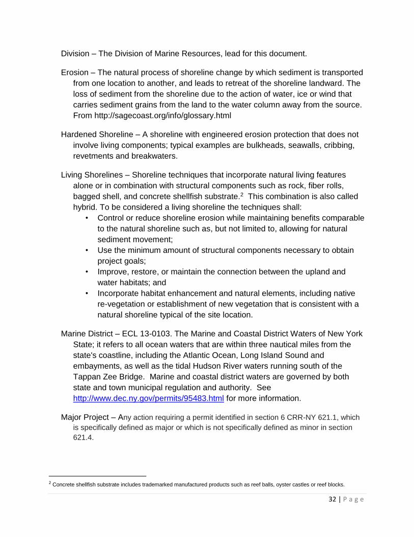
Living Shorelines – Shoreline techniques that incorporate natural living features
alone or in combination with structural components such as rock, fiber rolls,
bagged shell, and concrete shellfish substrate.2 This combination is also called
hybrid. To be considered a living shoreline the techniques shall:
• Control or reduce shoreline erosion while maintaining benefits comparable
to the natural shoreline such as, but not limited to, allowing for natural
sediment movement;
• Use the minimum amount of structural components necessary to obtain
project goals;
• Improve, restore, or maintain the connection between the upland and
water habitats; and
• Incorporate habitat enhancement and natural elements, including native
re-vegetation or establishment of new vegetation that is consistent with a
natural shoreline typical of the site location.
Marine District – ECL 13-0103. The Marine and Coastal District Waters of New York
State; it refers to all ocean waters that are within three nautical miles from the
state's coastline, including the Atlantic Ocean, Long Island Sound and
embayments, as well as the tidal Hudson River waters running south of the
Tappan Zee Bridge. Marine and coastal district waters are governed by both
state and town municipal regulation and authority. See
http://www.dec.ny.gov/permits/95483.html for more information.
Major Project – Any action requiring a permit identified in section 6 CRR-NY 621.1, which
is specifically defined as major or which is not specifically defined as minor in section
621.4.
2 Concrete shellfish substrate includes trademarked manufactured products such as reef balls, oyster castles or reef blocks.

33 | P a g e
Natural (as in Shoreline) – The unaltered (as in human intervention through
construction or other means) condition of a specific area; within this document,
this usually refers to the shoreline.
NYS – New York State.
Salinity – The saltiness or dissolved salt content of the body of water at the project
site is important to understand what types of plants are suitable at that location.
Stabilization – The artificial control of erosion through hardened, hybrid, or nature-
based techniques.
Tidal wetland – Any area delineated as tidal wetlands on an inventory map pursuant
to Article 25 of the ECL, more specifically all areas defined as tidal wetlands
pursuant to ECL § 25-0103(1) and 6 NYCRR § 661.4(hh).
Turbidity- The measure of relative clarity of a liquid.
Value of a tidal wetland – The combination of benefits provided by tidal wetlands.
Tidal wetlands constitute one of the most vital and productive areas of the natural
world and collectively have many values. These values include, but are not
limited to, marine food production, wildlife habitat, flood and storm and hurricane
control, recreation, cleansing ecosystems, sedimentation control, education and
research, and open space and aesthetic appreciation, as set forth in the
legislative findings contained in section 1 of chapter 790 of the Laws of 1973.
Uniform Procedures – 6 NYCRR Part 621.
B. Terms Defined in Other Sources
Brush mattresses – Live cuttings with branches on the slope with butt ends keyed
into toe protection. The branches are layered in a criss-cross overlapping pattern
and secured with wire and dead stout stakes. A rock toe or fascine is used for toe
protection. (Allen, et al. 2006, modified from USDA NRCS, 1996)
Bulkhead – A common shoreline protection technique comprising a vertical wall that
prevents the loss of soil and the further erosion of the shore. They can be made
of a variety of materials including rock, steel, concrete, and wood (Hauser 2012).
Fetch – The unobstructed distance of water over which the wind can blow. Fetch,
along with water depth and wind duration, leads to wave generation (Fagherazzi
and Wiberg, 2009).

34 | P a g e
Fiber Roll – A fiber roll is a coconut fiber, straw, or excelsior woven roll encased in
netting of jute, nylon, or burlap used to dissipate energy along bodies of water
and provide a good medium for the introduction of herbaceous vegetation. The
roll is anchored into the bank and, after suitable backfill is placed behind the roll,
herbaceous or woody vegetation can be planted. (NYSDEC 2005)
Hybrid approach – A hybrid shoreline is the combination of hardened structures with
natural materials (NJDEP 2014; Smith 2006; VaCZM 2012).
National Tidal Datum Epoch – To account for various tidal fluctuations, a 19-year
period of water level averaging, the National Tidal Datum Epoch (NTDE) has
been established by NOAA/NOS in the United States. NTDEs have included the
years 1924-1942, 1941-1959, 1960-1978, and most recently, 1983-2001.
http://www.ngs.noaa.gov/datums/vertical/
Protection, shoreline – A range of engineering responses that focus on protecting
land or landward infrastructure from erosion, inundation, or storm-induced
flooding (Hauser 2012).
Revetments – A common shoreline protection technique constructed of large rocks
or concrete armor units that slope toward shore. Rock revetments go through a
more rigorous engineering analysis and provide a higher degree of protection
than does rip-rap (Hauser 2012).
Rip-rap – A shoreline protection technique to armor a sloping shore by using small
rocks or, cobble, to protect the finer sized sediments from eroding. Rip-rap can
also refer to the material itself (Hauser 2012).
Shoreline – The term shoreline is used in many ways, including defining either a line
or an area. Therefore, several definitions are included here:
An “infinitesimally thin line that separates the water from the land” (Strayer
and Findlay 2010);
In New York State, the intersection of the mean high water line with the
beach profile; below mean high water may be privately or publicly owned;
The fringe area along the edge of a water body, which connects the
shallow aquatic portion of the water body with adjacent upland;
The zone of contact of a body of water’s surface and the land; or
The land along the edge of a body of water.
Related terms: shore zone, riverfront, coast, shore, waterfront, coastline (Hauser
2012).

35 | P a g e
Sills – Low profile, continuous structures placed parallel to the shore at mean low
water. Sills can be made of broken rock, cobbles or other hard material and
typically have a trapezoidal cross-section. Sills reduce shoreline erosion by
dissipating wave energy, which may cause sediment to build up between the sill
and the shoreline. This sediment may provide substrate for marsh growth
(Hauser 2012).
Taking of Threatened or Endangered Species – A taking includes not only the death
of individuals, but also any adverse modification of a species’ habitat, and any
interference with or impairment of an essential behavior of the species. See 6
NYCRR Part 182 for more detail.
Vegetated geogrid – A vegetated geogrid is a system of successive soil lifts wrapped
in a synthetic or natural fiber material with live branch cuttings placed between
layers (Allen, et al. 2006, modified from USDA NRCS, 1996)

36 | P a g e
Appendix B. Permit Application Checklist
Signed Joint Application Form
Signed Permission to Inspect Property
SEQR Short Environmental Assessment Form (EAF) – Part 1 completed &
signed. http://www.dec.ny.gov/permits/6191.html. DEC recommends the use of
the EAF mapper which allows you to select your site and will then generate a
partially filled-in form.
Required Additional Materials
o Location Map
o Project Plans (instructions on-line)
o At least three (3) recent color photographs of the site labeled with date
taken and orientation of photo
o Application Fee – refer to http://www.dec.ny.gov/permits/65153.html
Identification of adjacent landowners.
Project drawings showing all existing and proposed structures, the tidal wetland
boundary, apparent high water line, and existing & proposed elevation contours
in 2-foot intervals for the work area. The wetland boundary must be recently
(within 5 years) delineated by a qualified person. The apparent high water line
may also have to be delineated by a qualified person. Contact your regional
office.
USGS Quadrangle Map (or equivalent) showing the project location
o Map showing roads and proposed machinery access route
Letter signed by landowner; or, if application is not signed by landowner, letter
designating an authorized agent if application is not signed by landowner and, if
additional landowners are involved, signed letter(s) of permission for each.
Basic Drawing Requirements
Site Plans:
Scale (i.e. 1" = 50', 1" = 40') and north arrow.
Name of preparer and dated prepared and name of property owner.
Property lines and names of all adjacent landowners.
County tax map numbers.
37 | P a g e
Address of project location (street and number); if vacant land, give utility pole
number or other landmark.
Apparent high water line (AHW) and apparent low water line (ALW) *tidal
wetlands only.
Vegetated wetlands boundary, indicate name of individual delineating boundary
and date of delineation.
Outline and identify existing and proposed structures.
Dimensions of proposed structures/work areas, grade changes, excavation,
filling, and/or clearing.
Elevations referenced to NGVD 1929 or NAVD 1988 when applicable.
Crossviews:
Name of preparer and date prepared.
Water depths at low tide, apparent high water line (AHW) and low water line
(ALW).
Existing and proposed structures and grades.
Dimensions of all materials to be used or affected areas in inches or feet.
Distances between structures and components (i.e. distance between seaward
toe of proposed living shoreline structure and an existing fixed structure on
property such as a building or parking lot; vertical / horizontal distances between
seaward toe of proposed living shoreline structure and top or landward edge of
proposed structure).
Type of material(s) proposed.
Additional Drawing Details Required for Specific Activities:
For filling, dredge material deposition, excavating, clearing, grading, bluff or dune
restoration, or beach nourishment.
Site Plans:
Outline of area(s) to be affected by these activities.
Top and bottom of bluff or dune, if applicable.
If grade changes exceed 2 feet, contour lines showing existing and proposed
contours at 2-foot intervals.
Volume of material to be placed/removed in cubic yards.
Source and type of material involved (sand, silt, loam, rock).
Method of placing and removing material and location of disposal.
38 | P a g e
Crossviews:
Existing and proposed angle of surfaces.
Source and type of material proposed.
Volume of material, in cubic yards, to be placed.
Living Shoreline Treatments or Other Erosion Protection Structures
Site Plans:
Distances from existing substantial structures (i.e. dwelling or telephone pole) to
ends of proposed structure.
Source, type and volume (cubic yards) of material proposed for backfill.
Limits of backfill.
Direction of littoral drift.
Cross views:
Distances from existing structures.
Distances below grade of structural components.
Distances below apparent low water of project components.
If rock structures are proposed, minimum weights of all grades of stone used.
Backfill area.
DEC staff may require additional information to adequately review and evaluate the
application.
39 | P a g e
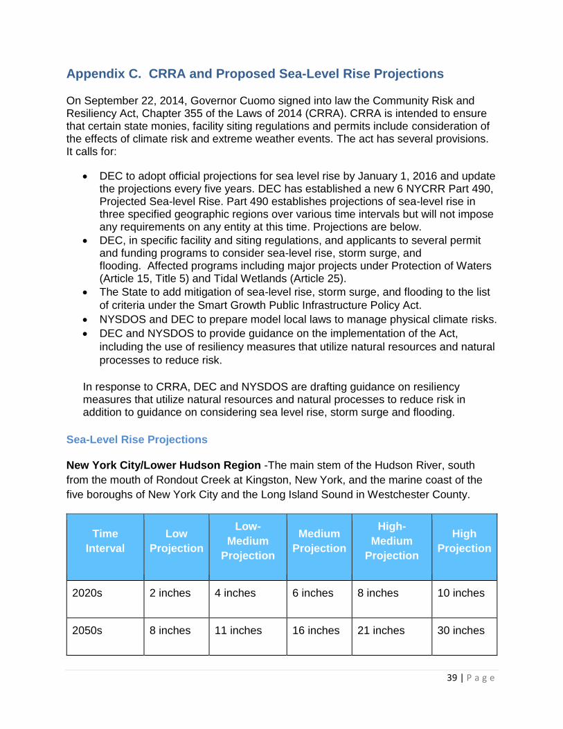
Appendix C. CRRA and Proposed Sea-Level Rise Projections
On September 22, 2014, Governor Cuomo signed into law the Community Risk and Resiliency Act, Chapter 355 of the Laws of 2014 (CRRA). CRRA is intended to ensure that certain state monies, facility siting regulations and permits include consideration of the effects of climate risk and extreme weather events. The act has several provisions. It calls for:
DEC to adopt official projections for sea level rise by January 1, 2016 and update the projections every five years. DEC has established a new 6 NYCRR Part 490, Projected Sea-level Rise. Part 490 establishes projections of sea-level rise in three specified geographic regions over various time intervals but will not impose any requirements on any entity at this time. Projections are below.
DEC, in specific facility and siting regulations, and applicants to several permit and funding programs to consider sea-level rise, storm surge, and flooding. Affected programs including major projects under Protection of Waters (Article 15, Title 5) and Tidal Wetlands (Article 25).
The State to add mitigation of sea-level rise, storm surge, and flooding to the list
of criteria under the Smart Growth Public Infrastructure Policy Act.
NYSDOS and DEC to prepare model local laws to manage physical climate risks.
DEC and NYSDOS to provide guidance on the implementation of the Act,
including the use of resiliency measures that utilize natural resources and natural
processes to reduce risk.
In response to CRRA, DEC and NYSDOS are drafting guidance on resiliency measures that utilize natural resources and natural processes to reduce risk in addition to guidance on considering sea level rise, storm surge and flooding.
Sea-Level Rise Projections
New York City/Lower Hudson Region -The main stem of the Hudson River, south
from the mouth of Rondout Creek at Kingston, New York, and the marine coast of the
five boroughs of New York City and the Long Island Sound in Westchester County.
Time
Interval
Low
Projection
Low-
Medium
Projection
Medium
Projection
High-
Medium
Projection
High
Projection
2020s 2 inches 4 inches 6 inches 8 inches 10 inches
2050s 8 inches 11 inches 16 inches 21 inches 30 inches

40 | P a g e
2080s 13 inches 18 inches 29 inches 39 inches 58 inches
2100 15 inches 22 inches 36 inches 50 inches 75 inches
Long Island Region -The marine coast of Nassau and Suffolk counties.
Time
Interval
Low
Projection
Low-
Medium
Projection
Medium
Projection
High-
Medium
Projection
High
Projection
2020s 2 inches 4 inches 6 inches 8 inches 10 inches
2050s 8 inches 11 inches 16 inches 21 inches 30 inches
2080s 13 inches 18 inches 29 inches 39 inches 58 inches
2100 15 inches 21 inches 34 inches 47 inches 72 inches
For definitions of the range projections (low to high) see
http://www.dec.ny.gov/regulations/103877.html. For example, high projection is the
amount of sea-level rise that is very unlikely (the 90th percentile of ClimAID model
outputs) to be exceeded by the specified time interval.
Values represent inches of rise over baseline level, which is defined as the average
level of the surface of marine or tidal water over the years 2000 through 2004.
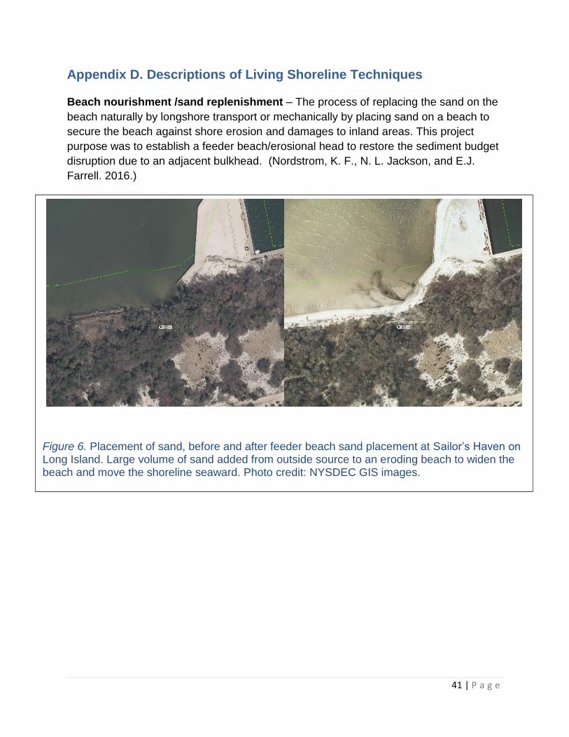
41 | P a g e
Appendix D. Descriptions of Living Shoreline Techniques
Beach nourishment /sand replenishment – The process of replacing the sand on the
beach naturally by longshore transport or mechanically by placing sand on a beach to
secure the beach against shore erosion and damages to inland areas. This project
purpose was to establish a feeder beach/erosional head to restore the sediment budget
disruption due to an adjacent bulkhead. (Nordstrom, K. F., N. L. Jackson, and E.J.
Farrell. 2016.)
Figure 6. Placement of sand, before and after feeder beach sand placement at Sailor’s Haven on Long Island. Large volume of sand added from outside source to an eroding beach to widen the beach and move the shoreline seaward. Photo credit: NYSDEC GIS images.

42 | P a g e
Vegetated Slope / Bank Restoration
Vegetated slopes are created using wetland or upland vegetation to control or prevent
further erosion by absorbing wave energy
and stabilizing the slope. Existing native
plants can be preserved or new native
species restored. When selecting species,
look for plants with substantial root
systems, to hold the soil. Shorelines in low
energy creeks and coves are locations
where vegetation alone can be used to
protect from erosion. See Figures 7 and 8.
Figure 8. Slope planted with native vegetation. Photo credit: New England Environmental, Inc.
Figure 7. Marsh planting along slope of
Occahannock Creek, Northampton County,
VA, at time of planting and one and ten
years later. Image credit: C.S. Hardaway,
VIMS from (Hardaway & Byrne 1999).
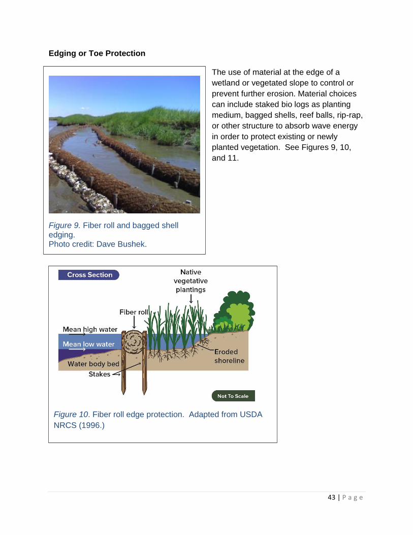
43 | P a g e
Edging or Toe Protection
The use of material at the edge of a
wetland or vegetated slope to control or
prevent further erosion. Material choices
can include staked bio logs as planting
medium, bagged shells, reef balls, rip-rap,
or other structure to absorb wave energy
in order to protect existing or newly
planted vegetation. See Figures 9, 10,
and 11.
Figure 10. Fiber roll edge protection. Adapted from USDA
NRCS (1996.)
Figure 9. Fiber roll and bagged shell edging. Photo credit: Dave Bushek.

44 | P a g e
Figure 11. Example of stone toe protection with a vegetated slope using bio-degradable geotextile and shrubs, upper left and right. Photo at left shows established shrubs and stone (toe at high tide), six years after installation at Esopus Meadows, NY. Photos courtesy of Creative Habitat Inc.
See Hudson River Sustainable Shorelines Case Study: Esopus Meadows Preserve https://www.hrnerr.org/doc/?doc=240260694.
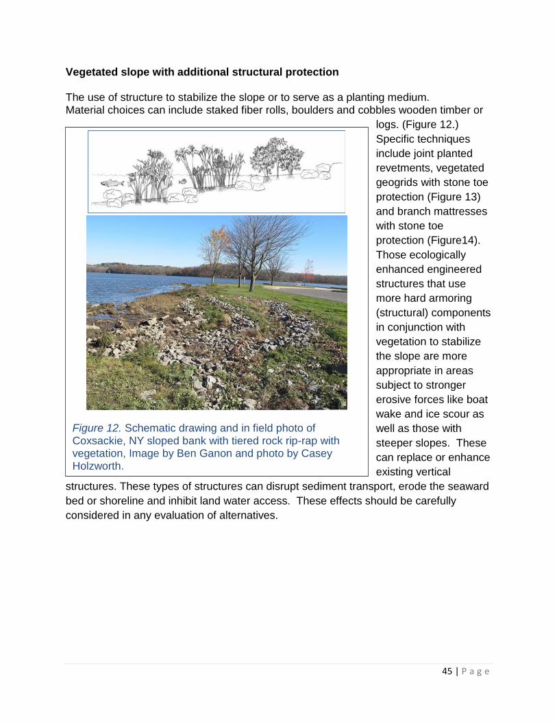
45 | P a g e
Vegetated slope with additional structural protection
The use of structure to stabilize the slope or to serve as a planting medium. Material choices can include staked fiber rolls, boulders and cobbles wooden timber or
logs. (Figure 12.)
Specific techniques
include joint planted
revetments, vegetated
geogrids with stone toe
protection (Figure 13)
and branch mattresses
with stone toe
protection (Figure14).
Those ecologically
enhanced engineered
structures that use
more hard armoring
(structural) components
in conjunction with
vegetation to stabilize
the slope are more
appropriate in areas
subject to stronger
erosive forces like boat
wake and ice scour as
well as those with
steeper slopes. These
can replace or enhance
existing vertical
structures. These types of structures can disrupt sediment transport, erode the seaward
bed or shoreline and inhibit land water access. These effects should be carefully
considered in any evaluation of alternatives.
Figure 12. Schematic drawing and in field photo of Coxsackie, NY sloped bank with tiered rock rip-rap with vegetation, Image by Ben Ganon and photo by Casey Holzworth.

46 | P a g e
Figure 13. Vegetated geogrid to protect slope with
stone toe protection. Adapted from USDS NRCS
(1996).
Figure 14. Brush mattress to protect slope with stone
toe protection. Adapted from USDS NRCS (1996).

47 | P a g e
Low profile sill for wave attenuation Sills are typically low profile, continuous or
intermittent structures placed parallel to the shore at mean low water, see Figure 15.
Sills can be made of broken rock, cobbles, bagged oyster shells or reef balls. Sills
typically have a trapezoidal cross-section. Sills reduce shoreline erosion by dissipating
wave energy, which may cause sediment to build up between it the sill and the
shoreline. This sediment can provide substrate for marsh growth. In some cases, the
area between the sill and the shoreline is prefilled and planted to accelerate the marsh
creation process; this approach is sometimes called a marsh sill. A sill is placed
offshore of existing marsh to help reduce the erosion of the waterward edge
(escarpment) where marsh would or could grow and is planted or placed to protect the
eroding edge of an existing marsh. These structures can effect sediment transport, so
design should consider those potential effects.
Figure 15. Schematic drawing and in field photo of marsh sill. Sill is composed of rock and has openings for aquatic fauna passage. Image and photo courtesy of: North Carolina Division of Coastal Management.
48 | P a g e
Appendix E. Information on Demonstration Projects
DEC’s Hudson River National Estuarine Research Reserve conducted a survey of
stakeholders in sheltered waters of New York, New Jersey, and Delaware. One finding
of the survey was that stakeholders expressed a need for information on project costs,
site conditions, design techniques, and successes and failures of living shorelines
(Tobitsch et al. 2014). At the time of writing this guidance document, there are several
on-line databases and websites with information that include some living shorelines that
have already been installed and other useful information. DEC is providing these
internet resources as an informational tools.
Hudson River Sustainable Shoreline Project Demonstration Site Network
(https://www.hrnerr.org/hudson-river-sustainable-shorelines/demonstration-site-
network/)
Hudson River Sustainable Shoreline Project Forensic Analysis of Shoreline
Structures on the Hudson River
https://www.hrnerr.org/shorelinesforensicanalysis/
Rella, A. & Miller, J. (2012b). A Comparative Cost Analysis of Ten Shore
Protection Approaches at Three Sites Under Two Sea Level Rise Scenarios. In
association with and published by the Hudson River Sustainable Shorelines
Project, Staatsburg, NY 12580, https://www.hrnerr.org/doc/?doc=240186100
NYS DOS Office of Planning and Development
Story map on living shorelines through the Geographic Information Gateway. It
includes a map of living shoreline projects in various stages throughout the state
as well as other reports/studies related to living shorelines in New York.
http://opdgig.dos.ny.gov/#/storyTemplate/11/1/1
Partnership for the Delaware Estuary
(http://delawareestuary.org/Living_Shorelines)
American Society of Civil Engineers - Coasts, Oceans, Ports, and Rivers Institute
(http://mycopri.org/)
Systems Approach to Geomorphic Engineering (SAGE) http://sagecoast.org
NOAA Habitat Conservation Restoration Center, Living Shorelines
http://www.habitat.noaa.gov/restoration/techniques/lsimplementation.html
VIMS Center for Coastal Management
http://ccrm.vims.edu/livingshorelines/demonstration_area_map.html