Embed Size (px)
Citation preview

c: iA i
ro
U.S. 27 From Lansing to Ithaca
Clinton and Gratiot Counties, Michigan
C 5 AC32 ^03/
O en
-n
' o r* c« (-« m
o
Q
3»
z en
o
in STRATIVE A IT T p I
!
ECTION IV OF
T
ION
ALIGNMENT ENVIRONMENTAL IMPACT STATEMENT
Dated March 9, 1977
U.S. DEPARTMENT OF TRANSPORTATION
FEDERAL HIGHWAY ADMINISTRATION
o
and
MICHIGAN DEPARTMENT OF
STATE HIGHWAYS AND TRANSPORTATION
en so 3»
Q -i
o o
Submitted Pursuant to U.S.C. 4332 (2) (e)
23 U.S.C. 128 (a)
U.S. DEPARTMENT OF TRANSPORTATION F E D E R A L H I G H W A Y A D M I N I S T R A T I O N
REGION 5
18209 OIXIE HIGHWAY
HOMEWOOD. ILLINOIS 6 0 4 3 0
Report Number: FHWA-MICH-EIS - 77-02-D (S)
U.S. 27 from Lansing to Ithaca
Clinton and Gratiot Counties, Michigan
ADMINISTRATIVE ACTION
Supplement To
Section IV
of
DRAFT
ALIGNMENT ENVIRONMENTAL IMPACT STATEMENT
Dated
March 9, 1977
U.S. DEPARTMENT OF TRANSPORTATION Federal Highway Administration
and
Michigan Department of S t a t e Highway and T r a n s p o r t a t i o n
Submitted Pursuan t t o 42 U.S.C. 433s (2) (e) 23 U.S.C. 128 (a)
"T^ate Division Administrator
\
SUMMARY

Administrative Action
(X) Draft - Supplement to Section IV of Draft Alignment Environmental Impact Statement dated March 9, 1977.
(X) Environmental Statement
( ) Final ( ) Combination Environ
mental/Section 4 (f) Statement
Request for the Supplement to Section IV of the Draft Alignment Environmental Impact Statement (dated March 9, 1977) and/or information pretaihing to the latter, should be addressed to:
Mr. Ronald H. Jones Staff Specialist of Environment Federal Highway Administration 211 Federal Building Lansing, Michigan 48901 Telephone - (517) 373-2094
Mr. Jack Morgan Public Involvement Section Michigan- Department of State Highways and Transportation State Highway Building 425 West Ottawa Lansing, Michigan 48933 Telephone -Toll Free 1 (800) 292-9576
Mr. Robert R. Henry, Jr. WILBUR SMITH AND ASSOCIATES Suite 102 Oakland Center 809 Center Street, Lansing, Michigan 48906 Telephone - (517) 485-6500
Description of Action
The Michigan Department of State Highways and Transportation (MDSHT) proposes to construct a four-lane rural freeway beginning approximately 0.3 mile north of M-21 and 1.25 miles east of St. Johns and extending in a north-westerly direction intersecting existing US-27 (the recommended freeway alignment from the Gratiot County line to 0.2 mile north of Pierce Road) approximately 0.7 miles north of Gratiot Road. The supplemental project length is approximately 10 miles. The proposed rural freeway from proposed 1-69 on the south to beginning point of this segment and from the end of this segment to Ithaca was discussed and impacts reviewed and presented in the Draft Alignment Environmental Impact Statement dated March 9, 1977.
Summary of Environmental Impacts and Adverse Environmental Effects of an Alignment on New Location Verses Adjacent to Existing US-27.

Positive:
a. Freeway on new location will allow the local citizens access to a four lane facility (existing US-27) for movement of commodities and equipment;
b. Relocations will be less severe;
c. Construction and Right-of-Way cost will be lower;
d. Impact upon the tax base will be less severe;
e. Reduction in cost to the farmer as he will not be regulated to a service road; and
f. Reduction in air and noise pollution:
Negative:
a. Severance of farming operations will be more severe; b. Up to approximately 30 percent more agricultural
land will be required;
c. Potentially more acres of higher yield crop land - will be required;
d. Disruption of woodlots will affect wildlife habitat and aesthetic resources;
e.. Social impact upon the community will be more pronounced; and
f. Less utilization of existing Right-of-Way.
Alternatives Considered:
Freeway Alternatives
Federal, State, and Local Agencies and Offices from which Comments on the Draft Alignment Environmental Impact Statement were Requested and/or Received:
Agency Comments Requested Received
A. Federal
Council on Environmental Quality (CEQ) X Department of Transportation
Assistant Secretary for , Environmental and Urban • Systems X
ii
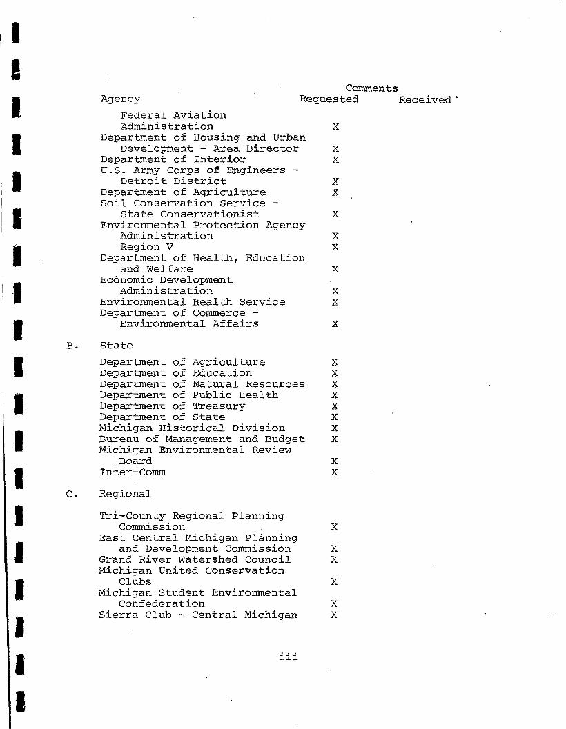
Comments Agency Requested Received
Federal Aviation Administration X
Department of Housing and Urban Development - Area Director X
Department of Interior X U.S. Army Corps of Engineers -
Detroit District X Department of Agriculture X Soil Conservation Service -
State Conservationist X Environmental Protection Agency
Administration X Region V X
Department of Health, Education and Welfare X
Economic Development Administration X
Environmental Health Service X Department of Commerce -
Environmental Affairs X
B. State
Department of Agriculture X Department of Education X Department of Natural Resources X Department of Public Health X Department of Treasury X Department of State X Michigan Historical Division X Bureau of Management and Budget X Michigan Environmental Review
Board X Inter-Comm X
Regional
Tri-County Regional Planning Commission X
East Central Michigan Planning and Development Commission X
Grand River Watershed Council X Michigan United Conservation
Clubs X Michigan Student Environmental
Confederation X Sierra Club - Central Michigan X
iii

Agency Comments
Requested Received
D. Local
Clinton County Board of County Commissioners ' • • .. - X
Clinton County Road Commission X Clinton County Planning
Commission . X Gratiot County Board of County
Commissioners ' X Gratiot County Planning
Commission • . X St. Johns City Commission • X St. Johns Planning Commission. X League of Women Voters - Gratiot
County • X Lansing Planning Department X East Lansing Planning Department' X Bingham Township Board ' . X DeWitt Township Board. "'•'.' X Greenbush Township Board' . X North Star Township Board -. X Olive Township Board.-. '.•'•,••••" X Washington Township .Board . •• • X
Permits . •;.
It is expected that the following permits will be required prior to construction of this p'roject.
A. U.S. Army Corps ,6f Engineers:
1. Federal .Water Pollution Control Act, Section .401 (a) (1) .
2. Federal Water Pollution Control Act, Section-'-404 .'
B. Michigan Department of Natural Resources:
1. The Michigan Department of State Highways and Transportation is self regulated with regard to Michigan Public Act 347, Soil Erosion and Sedimentation Control Act.
2. Michigan Public Act 346, Inland Lakes and Streams Act.
3. Federal Act 245, National Pollution Discharge Elimination System.
iv

TABLE OF CONTENTS
TABLE OF CONTENTS
SECTION PAGE
SUMMARY i Administrative Action i Request for the Supplement to Section IV of
Draft Alignment Environmental Impact Statement i Description of Action i Summary of Environmental Impacts and
Adverse Environmental Effects i Alternatives Considered ii Federal, State and Local Agencies From
Which Comments are Solicited ii Permits ii
TABLE OF CONTENTS i
INTRODUCTION and BACKGROUND OF SUPPLEMENTAL STUDY S-l Alternatives S-3 Transportation Impact S-3
ALTERNATIVE ALIGNMENT F-l S-4 Transportation Impact S-4 Safety S-5 Natural System Impact S-7 Social Impact S-9 Relocation S-10 Economic Impact S-10 Air and Noise Impact S-ll
ALTERNATIVE ALIGNMENT F-3 S-12 Transportation Impact S-l3 Safety S-13 Natural System Impact S-16 Social Impact S-17 Relocation S-18 Economic Impact S-18 Air and Noise Impact S-18
ALTERNATIVE ALIGNMENT F-5 S-l9 Transportation Impact " S-20 Safety S-22 Natural System Impact S-22 Social Impact S-24 Relocation S-25 Economic Impact S-25 Air and Noise Impact S-26
v

TABLE OF CONTENTS (CONT'D)
SECTION PAGE
ALTERNATIVE ALIGNMENT G (Partial) - S-26 Transportation Impact S-27 Safety S-28 Natural System S-28 Social Impact S-30 Relocation S-31 Economic Impact S-31 Air and Noise Impact S-32
COST ESTIMATES S-32 Alternative F-l S-34 Alternative F-3 S-34 Alternative F-5 S-35 Alternative G (Partial) S-35
SUMMARY ' S-36
APPENDICES
S-A Letter from State Archeologist Concerning Potential Archeological Sites
vi

ILLUSTRATIONS
FIGURE
S-SA
S-l
S-2
S-3
S-4
S-5
S-6
S-7
S-8
Supplemental Study Area
Preliminary Alternatives
Practical Alternatives
Typical Cross - Sections
Projected ADT - 1995
Alignment F-l
Alignment F-3
Alignment F-5
Alignment G (Partial)
FOLLOWS
S-l
S-3
S-3
S-3
S-3
S-4
S-12
S-19
S-26
v i i
TABULATION
TABLE NUMBER , PAGE
S-l Frequent Traveler Costs S-6
S-2 Predicted' 1995 Accident Data
Alternative F-l S-8
S-3 Frequent Traveler Costs S-14
S-4 Predicted 1995 Accident Data
Alternative F-3 ' S-15
S-5 Frequent Traveler Costs S-21
S-6 Predicted 1995 Accident Data Alternative F-5 S-23
S-7 Predicted 1995 Accident Data
Alternative G (Partial) S-29
S-8 Cost Estimates S-33
S-9 Summary of Quantifiable Impacts and Cost Estimates S-37
v m

IMPACT AND COST ANALYSIS

INTRODUCTION AND BACKGROUND OF SUPPLEMENTAL STUDY
The Corridor Analysis Phase of the US-27 Corridor and Route Location Study concluded with the decision by the State Highway Commission in November, 1975, to develop alternative alignments in two corridors from the proposed I-69/US-27 and the US-127/ US-27 interchange and Kinley Road (north of St. Johns) Figure S-SA. From Kinley Road to Pierce Road (south of Ithaca - termination point), the existing US-27 Corridor was selected for development of the proposed freeway.
Corridor I - incorporated development of the No Build Alternative and/or freeway type facility along existing US-27, including an easterly bypass of St. Johns, from the US-127/US-27 interchange to Kinley Road.
Corridor II - began at the proposed I-69/US-127 interchange then continued in a north-northwesterly direction between Williams and Chandler Roads intersecting existing US-27 in the vicinity of Kinley Road.
Crossover Region - included an area between Corridors I and II that could be used for combining segments of both corridors.
Kinley Road to Pierce Road - incorporated development of the No Build Alternative and/or freeway type facility along existing US-27 alignment.
The project proceeded with development of alignments in the corridors described above. The alignments and their impacts were presented- in the Draft Alignment Environmental Impact Statement (Report # FHWA-MICH-EIS-77-02-D) dated March 9, 1977. The alternative alignments were presented at a public hearing in June, 1977.
Although, most of the responses received from Federal, State and Local agencies and local citizens supported a freeway type facility, they disagree on which alignment it should follow. The Department of Agriculture suggest that the proposed freeway follow the existing US-27 alignment with an easterly bypass of St. Johns. The Department of Natural Resources preferred the No Build option, however, if a freeway is needed, they suggested .that it be adjacent to the existing US-27 alignment with an easterly bypass of St. Johns. Likewise, the Michigan United Conservation Clubs supported a freeway adjacent to existing US-27, but with maximum use of existing right-of-way. . The Michigan

Student Environmental. Confederation supported the No Build approach rather than a comprehensive improvement.
Comments received from the Board of County Commissioners of Clinton County, Clinton County'Planning Commission, Greenbush Township Board and several citizens from Greenbush Township, supported an alignment to the east of US-27 in Greenbush Township. Specifically, the Board of County Commissioners suggested that Alignment E/F be continued straight north from M-21 through Greenbush Township intersecting Alternative G (north of Kinley Road to Pierce Road) in the vicinity of Maple Rapids Road.
Approximately 75 percent of the citizens in Clinton County submitting statements for the record, supported an alignment on a new location. in Greenbush Township, where the proposed freeway facility is to follow the existing US-27 alignment, 68 percent supported an alignment on a new location. This support was based on: (1) Agricultural land to the east of US-27 is less productive; (2) An alignment oh new location will have fewer relocations and will be less expensive; (3) An alignment on new location will provide farmers with a four lane facility (existing* US-27) for transportation of their produce to the market, whereas, use of existing. US-27 for the proposed freeway affords them a two, lane service road of lesser quality than the existing highway; (4) An alignment on new location would disrupt fewer farming . "• operations than use of the existing as proposed; and (5) That. -an undue hardship would be placed upon those families along US-27 because of the disruption from the past improvements during the last 20 years..
In response to the local desires in Greenbush Township and because of a possible .4 (f) requirement (Coleman's Hotel and Salt Box House at corner of French Road and US-27) the State Highway Commission requested that a comparison be made of alternate alignments on new location with the preferred solution in Greenbush Township. .The Supplemental Area is delineated in Figure S-SA.
This document is a Supplemental to Section IV of the Draft Alignment Environment Impact Statement dated March 9, 1977. The other Sections of. the original document remain valid and are referred to in this document as appropriate. The Final Environmental Impact Statement will include information presented in this document as well as the original draft statement. Illustrations used in this document are referred to as Figure • S-l, S-2, etc., whereas those of the original Draft Statement -are referred to as Figure 19, 20, etc.
S-2
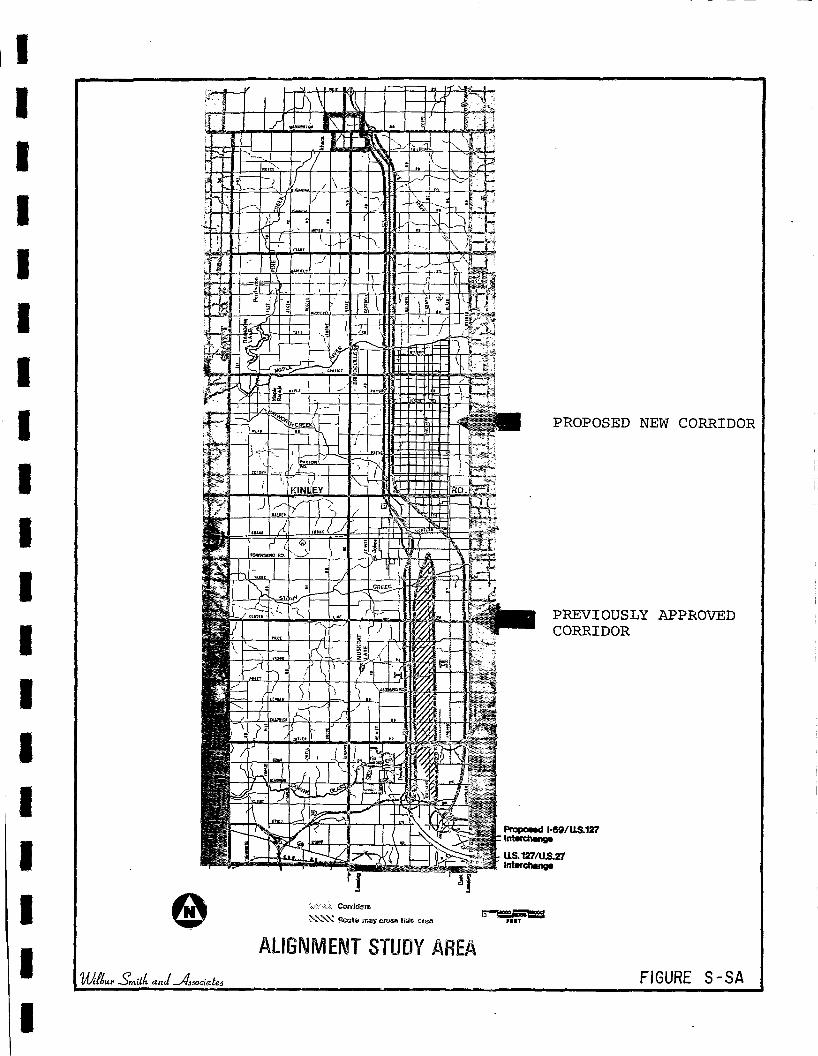
£f1N-
©
PROPOSED NEW CORRIDOR
PREVIOUSLY APPROVED CORRIDOR
NNSX Real© masy epaes Mil* ar©a
ALIGNMENT STUDY AREA
Propose) I69/US.127 : bttatchang*
US.127/US.27 Interchange
wnssssssess r n r
'Ubur Omi'M- and ~^Masociale: FIGURE S-SA
Alternatives
In developing alternatives for the Supplemental Study Area, the Do Nothing and No Build Alternatives have not been considered as viable alternatives. This is based on the Findings and Recommendations, transmitted to the Michigan Department of State Highways and Transportation in August, 1977, which stated that a freeway be constructed between Lansing and Ithaca. Therefore the Supplemental Study only involves the development of alternative alignments within the area described above rather than the complete range of alternatives, which were analyzed in the Draft Alignment Environmental Impact Statement dated March 9, 1977.
Initially, several alignment alternatives were developed (Figure S-l) without regard to physical or environmental constraints. From these schemes evolved a series of practical alignment alternatives for detailed analysis and comparison of technical, social and natural systems impacts. This document presents a comparative analysis for Alternative Alignments F-l, F-3, F-5 and G (Partial) (Figure S-2). Alternative G (Partial) is an alignment that modifies Alternative G (Kinley Road to north of Pierce Road) that was discussed in the Draft Alignment Environmental Impact Statement dated March 9, 1977 and presented at the Public Hearing in June, 1977. The latter has been modified so that the analysis presented in this document is comparable for each of the freeway alternatives. Changes to the original alternative include: (a) Beginning the alignment 0.3 mile north M-21 rather than at Kinley Road; (b) Redesigning and simplifying the Kinley Road interchange; (c) Terminating the alignment approximately 0.7 mile north of the Gratiot County line (for the Supplemental Study) rather than 0.2 mile north of Pierce Road; and (d) Incorporating the relocation and design changes for the French Road area and Maple Rapids Road area.
Each of the alternatives has been designed according to similar standards which are derived from Michigan Department of" State Highways and Transportation (MDSHT) criteria. Typical cross-section for construction of the proposed freeway includes a dual 24 foot roadway separated by a 94 foot median and a standard right-of-way of 300 feet (Figure S-3). An additional width may be required for special roadway and drainage design considerations and at interchanges and grade separations.
Transportation Impact
Average daily traffic volumes projected for the year 1995 for each of the practical alignment alternatives (F-l, F-3, F-5 and G (Partial)) is illustrated in Figure S-4. The various alternatives are expected to generate similar levels of traffic on both free-
S-3

way and crossroad segments. In addition, the anticipated traffic volumes on crossroads interchanging with the proposed freeway, are expected to be similar for the four alternatives.
ALTERNATIVE ALIGNMENT F-l
At Route M-21, F-l Alignment is situated one quarter-mile east of Williams Road (Figure S-5). The alignment extends northward along that location to a crossing of the Grand Trunk Railroad and Steel Road. The Grand Trunk Railroad would be bridged, but current examinations indicate Steel Road could be closed without seriously affecting local circulation.
Alternative F-l Alignment curves to the west crossing Walker Road and Williams Road. Current plans include a bridge at Williams Road, but Walker Road would not be bridged—it would be connected to Williams Road.
This alignment continues west passing between Avery Road and Consumer's Power Transmission line; just to the south of Avery Road. It then proceeds westerly and curves northward, while crossing Scott Road and Kinley Road. Scott Road would be bridged.
The alignment extends northward along the half-section line, one-half mile east of present US-27. Kinley Road would be closed, while current plans indicate F-l Alignment would bridge Colony Road. Silvers Road would be closed, but a bridge would be provided at French Road. Mead Road would be .closed, but Marshall Road would be bridged.
Between Marshall Road and Hyde Road, the F-l Alignment curves northwestward and then northward to a connection with existing • US-27 alignment, just south of Maple Rapids Road. Hyde Road would not be bridged.
Maple Rapids Road would be relocated approximately 100 feet to the south of present alignment. Current plans allow an interchange between the F-l Alignment and Maple Rapids Road. Full access would be provided allowing traffic movement between Maple Rapid's Road and destinations to the north and south.
North of Maple Rapids Road, F-l Alignment follows the alignment of present US-27, to a crossing of the Maple River.
Transportation Impact
Traffic usage levels in 1995 on Alternative F-l Alignment are shown on Figure S-4. Between Route M-21 and Maple Rapids Road,
S-4

BINGHAM
LEGEND!
!i!i!i!ii!iii!!!!
BINGHAi
LEGEND:
iiiwmmm TOWNSHIP BOUNDARY
BEGIN SUPPLEMENTAL STUDY
THOUSANDS OF FEET
12 PROJECTED ADT - 1995
^mitk and ^Ms&ocialte FIGURE S—

EXISTING R-O-W
145 Minimum
EXISTING U.S.27 R-O-W
VARIES
24'1
Existing Pavement To Be Abandoned
150
24
94
24
FREEWAY ALTERNATIVE ADJACENT TO EXISTING DUAL ROADWAY
FINAL
R-O-W
150 150
R-O-W
24
94
24'
FREEWAY ALTERNATIVE ON NEW ALIGNMENT
iwuf J^mith and sviiociatei
TYPICAL CROSS-SECTIONS FIGURE S-3

BINGHAi
LEGEND:
iiiwmmm TOWNSHIP BOUNDARY
BEGIN SUPPLEMENTAL STUDY
THOUSANDS OF FEET
12 PROJECTED ADT - 1995
^mitk and ^Ms&ocialte FIGURE S—

3E 7
1331S
•yy mnui ONVHS
IZ-W
ivoaiiM
CO
co
QN3SN«0±


![Great Lakes. The Five Great Lakes Lake Michigan [ touches Michigan] Lake Michigan [ touches Michigan] Lake Erie [touches Michigan] Lake Erie [touches](https://img.pdfslide.net/doc/110x75/56649dca5503460f94ac1371/great-lakes-the-five-great-lakes-lake-michigan-touches-michigan-lake-michigan.jpg)