Embed Size (px)
Citation preview
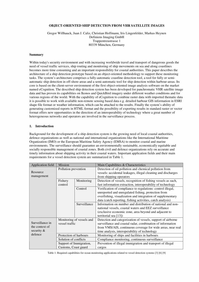
OBJECT-ORIENTED SHIP DETECTION FROM VHR SATELLITE IMAGES
Gregor Willhauck, Juan J. Caliz, Christian Hoffmann, Iris Lingenfelder, Markus Heynen
Definiens Imaging GmbH
Trappentreustrasse 1
80339 München, Germany
Summary
Within today's security environment and with increasing worldwide travel and transport of dangerous goods the
need of vessel traffic services, ship routing and monitoring of ship movements on sea and along coastlines
becomes more time consuming and an important responsibility for coastal authorities. This paper describes the
architecture of a ship detection prototype based on an object-oriented methodology to support these monitoring
tasks. The system’s architecture comprises a fully-automatic coastline detection tool, a tool for fully or semi-
automatic ship detection in off-shore areas and a semi-automatic tool for ship detection within harbour-areas. Its
core is based on the client-server environment of the first object-oriented image analysis software on the market
named eCognition. The described ship detection system has been developed for panchromatic VHR satellite image
data and has proven its capabilities on Ikonos and QuickBird imagery under different weather conditions and for
various regions of the world. With the capability of eCognition to combine raster data with imported thematic data
it is possible to work with available non-remote sensing based data e.g. detailed harbour GIS information in ESRI
shape file format or weather information, which can be attached to the results. Finally the system’s ability of
generating customized reports in HTML format and the possibility of exporting results in standard raster or vector
format offers new opportunities in the direction of an interoperability of technology where a great number of
heterogeneous networks and operators are involved in the surveillance process.
1. Introduction
Background for the development of a ship detection system is the growing need of local coastal authorities,
defence organizations as well as national and international organizations like the International Maritime
Organization (IMO) or the European Maritime Safety Agency (EMSA) to monitor coastal and marine
environments. The surveillance should guarantee an environmentally sustainable, economically equitable and
socially responsible management of coastal zones. Both civil and defence organizations rely on accurate and
timely information about shipping activity in their coastal waters. Important application fields and their main
requirements for a vessel detection system are summarized in Table 1.
Application field Mission Main Capabilities & Characteristics
Pollution prevention Detection of oil pollution and chemical pollution from
vessels: accidental leakages, illegal cleaning and discharges
from shipping operators
Monitoring Detection of vessels, recognition of fishing vessels as such,
fast information extraction, interoperability of technology
Control Verification of compliance to regulations: control illegal,
unreported and unregulated fishing, protection from
overfishing, visualization and integration of supplementary
data (catch reporting, fishing activities, catch analysis)
Resource
management
Fishery
control
Surveillance Information on number and distribution of national and non-
national vessels, coastal waters and EEZ surveillance
(exclusive economic zone, area beyond and adjacent to
territorial sea [13])
Monitoring of vessels and
vessel traffic
Detection and categorization of vessels, support of airborne
surveillance and coastal radar, combination of information
from VMS/AIS, continuous coverage for wide areas, near real
time analysis, interoperability of technology
Protection of harbours Monitoring of ships and facilities in harbours
Solution of conflicts Compliance monitoring, continuous surveillance
Surveillance in
the context of
security &
defence
Support of Immigration,
Customs, Coast guard
Prevention of illegal immigration and transport of illegal
cargos
Table 1: Required capabilities for ocean monitoring applications related to vessel detection systems [3] [6] [9]
Most application fields need the vessels to be detected and categorized in as much detail as possible and afterwards
the extracted information has to be transferred to existing systems. Hence fusion of information from different
information systems is of great importance. For example modern ships beyond a certain size are mostly equipped
with so called Automatic Identification Systems (AIS) and Voyage Data Recorder (VDR) systems. They identify
themselves before leaving or entering a harbour and after having passed technical inspections by authorized
entities. Fishing vessels in the European Union larger than 15 m [9] are equipped with a vessel monitoring system
(VMS) which allows the monitoring of vessels’ location and movements in real time. However, many ships are not
equipped with these systems, for example smaller fishery vessels and passenger boats do not have to apply with
this directives. In general these civil systems rely on the active cooperation of the ship with the authorities.
Remote sensing based on space-borne and airborne data is regarded as a technology to support the active system
with passive measurements for non-cooperating ships, sensing of non-harbour regions and monitoring purposes
[6]. Increased geometric resolution of the data and enhanced processing capabilities allow the installation of fully-
automatic vessel monitoring systems based on synthetic aperture radar (SAR) with near real time capability. On
one hand SAR Imagery is advantageous due to the ability to scan large areas and its independence from weather
and light conditions. On the other hand individual identification and classification of vessels on a higher detail
level is difficult with SAR data.
Much less research and developments has been conducted for automatic detection and classification of vessels in
optical imagery than for SAR imagery [2] but the use of optical data should be extended to provide additional and
completely new information. Based on the eCognition ship detection prototype the extraction and exchange of
information based on optical data for maritime areas is possible and beyond that the transfer of information to
other surveillance fields is feasible. The described prototype uses a new and unique approach in the application
field of ship detection.
2. Methodology
2.1. Software architecture
The current system is based on Definiens Imaging’s eCognition Enterprise software which is offering a distributed
computing environment. This enables high throughput image analysis by efficient workload distribution on
different servers. The execution is controlled by one or more clients. Image data, application modules and
application results are managed by a central database. Servers (Analysis Engines), clients and the database are
connected by a Message Oriented Middleware (MOM). To apply stored application modules on images, the clients
send an appropriate message to the MOM. The MOM distributes the processing tasks to the servers and sends the
results to the database. To visualize or manually edit processing results, the clients have respective access to the
database. eCognition Enterprise can be installed either as a standalone application or within a network with
distributed components.
The following features facilitate the expert’s interaction for ship detection and recognition:
• manual editing: automatically generated image objects can be manually corrected and classified if
necessary. The results are stored and tracked in the database.
• manual shape file generation: to overcome missing or inadequate GIS information delineating coastlines,
it is possible to manually generate respective ESRI shape files using the clients.
• report generation: after processing, individual reports on each vessel can be generated in HTML format.
The format and contents of the reports are widely selectable.
The system’s integrated database guarantees an easy interaction with MS Access or Oracle databases and as such
an advanced data query can be made. The distributed computing environment with batch processing capabilities
and the integrated messaging system allows a high-throughput of images and full operational use of the
methodology operating even in satellite ground stations with typically very high data throughput. Redundancy due
to additional servers can be used to ensure 24 hours operation. Remote clients enable convenient and fast access to
the information within an Intranet and soon also within the Internet. The enhanced tools for convenient remote
post-processing and object annotation support easy ship recognition saving the valuable time of image analysis
experts.
2.2. Workflow
The current system for ship detection consists of three main modules:
• Coastline detection
• Ship detection off-shore and in coastal areas
• Ship detection in harbour areas. An accurate thematic layer of the land/water-boundary is necessary
An accurate data set of the coastline is necessary for an accurate detection of ships especially in harbour areas.
Therefore before the ship detection module can be run, this data has to be created or imported into the system.
With the coastline detection module a fast and fully automatic delineation of the coastline is possible. This
detection provides a mask of open water, larger islands and land surface after an easy calibration for special
landscapes and sensors. The algorithm is loadable as an application module and can be stored in the database. It
determines the coastline on per-pixel accuracy. For cases where an exact distinction between land and sea is hardly
feasible (e.g. for shallow waters or cloud-covered coastlines), the coastline can be corrected manually.
Alternatively, coastline data can be imported using already existing GIS data. With the thematic editing
capabilities of eCognition the imported coastline data can be compared visually with the image data and edited
directly where necessary to ensure maximum accuracy. Furthermore the coastline could be generated manually by
digitizing in an electronic light table manner. The editing results can be saved as ESRI Shape file(s) in the
eCognition data base and reapplied for further applications where necessary or exported to be used in GIS
applications.
After coastline data is present the appropriate ship detection module can be chosen, depending whether off-shore
areas or areas within the harbour shall be analyzed.
The off-shore analysis delivers information on vessel size, position (in geo-coordinates) and shape information.
Vessels can be further distinguished in eCognition with respect to their location, e.g. according to their distance to
the coast, if they are located in shallow or deep water and furthermore their distance to any other defined object
(e.g. certain position in a convoy).
Within harbour areas the algorithm is designed to support the human expert for ship recognition. It allows the
integration of special information delivered from a harbour GIS, e.g. special pier functions and military or civil
harbour areas. An automatic process screens the images and is designed to detect all possible ships.
Additionally, the system has integrated tools for simplified reduction of false alarms and a fast visual check of all
identified objects. Within the visual verification process manual editing of the detected ships can be done by either
cutting merged ships to get single ships or by merging a ship which might be cut into pieces. After this visual
verification and editing step an automatic refinement algorithm is applied to reshape the outline of the ships.
Finally, an automatic categorization can be added, which further reduces the workload of the expert and allows
focusing on difficult and most important areas.
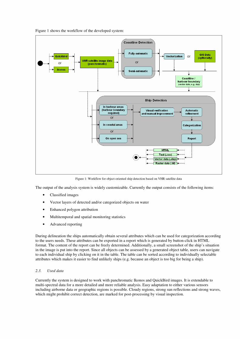
Figure 1 shows the workflow of the developed system:
Figure 1: Workflow for object-oriented ship detection based on VHR satellite data
The output of the analysis system is widely customizable. Currently the output consists of the following items:
• Classified images
• Vector layers of detected and/or categorized objects on water
• Enhanced polygon attribution
• Multitemporal and spatial monitoring statistics
• Advanced reporting
During delineation the ships automatically obtain several attributes which can be used for categorization according
to the users needs. These attributes can be exported in a report which is generated by button-click in HTML
format. The content of the report can be freely determined. Additionally, a small screenshot of the ship’s situation
in the image is put into the report. Since all objects can be assessed by a generated object table, users can navigate
to each individual ship by clicking on it in the table. The table can be sorted according to individually selectable
attributes which makes it easier to find unlikely ships (e.g. because an object is too big for being a ship).
2.3. Used data
Currently the system is designed to work with panchromatic Ikonos and QuickBird images. It is extendable to
multi-spectral data for a more detailed and more reliable analysis. Easy adaptation to either various sensors
including airborne data or geographic regions is possible. Cloudy regions, strong sun reflections and strong waves,
which might prohibit correct detection, are marked for post-processing by visual inspection.
3. Results
3.1. Classification Results
In the following some examples of results for the different modules are shown.
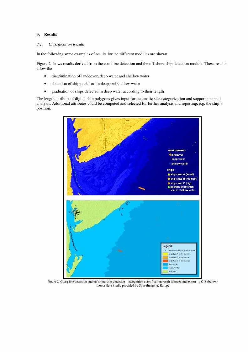
Figure 2 shows results derived from the coastline detection and the off-shore ship detection module. These results
allow the
• discrimination of landcover, deep water and shallow water
• detection of ship positions in deep and shallow water
• graduation of ships detected in deep water according to their length
The length attribute of digital ship polygons gives input for automatic size categorization and supports manual
analysis. Additional attributes could be computed and selected for further analysis and reporting, e.g. the ship‘s
position.
Figure 2: Coast line detection and off-shore ship detection – eCognition classification result (above) and export to GIS (below).
Ikonos data kindly provided by SpaceImaging, Europe

In Figure 3 the result of a fully automated detection of the coastline and ships on the ocean are shown. The data
export function of the system was used to visualize the data in a GIS environment.
Figure 3: Result of fully automated detection of coastline and ships off-shore using eCognition ship detector. Illustration within a GIS
environment. Ikonos data kindly provided by SpaceImaging, Europe
Figure 4 shows results from the ship detection module working in complex harbour structures. The detected ships
are categorized according to their length. A separation and classification according to the ships’ texture and shape
could be chosen as well. According to the previously introduced workflow results were achieved in a semi-
automatic approach using harbour GIS data and the integrated editing functions. This procedure allows a fast and
easy removal of false alarms and convenient separation of adjacent ships or fusion of ship parts.
In Figure 5 the user interface of the ship detection system is shown. The attribute table is directly linked to the
classified ships in the image to provide fast access from the table to the image in vice versa.
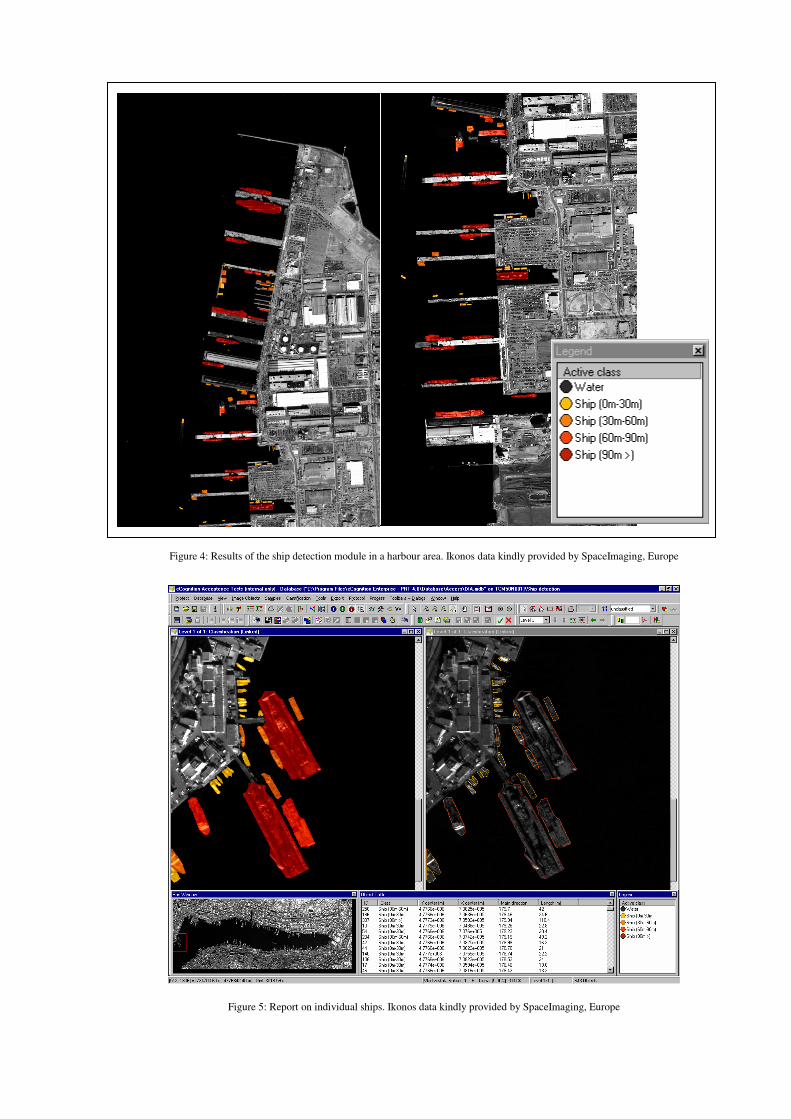
Figure 4: Results of the ship detection module in a harbour area. Ikonos data kindly provided by SpaceImaging, Europe
Figure 5: Report on individual ships. Ikonos data kindly provided by SpaceImaging, Europe
3.2. Enhanced Polygon Attribution
All objects can be exported as polygons provided with a large number of attributes. The attributes are freely
selectable and programmable. Typical attributes are geographic position, area, shape and texture characteristics of
ships and the distance to special pier facilities.
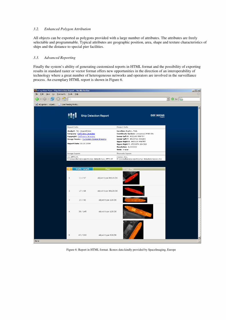
3.3. Advanced Reporting
Finally the system’s ability of generating customized reports in HTML format and the possibility of exporting
results in standard raster or vector format offers new opportunities in the direction of an interoperability of
technology where a great number of heterogeneous networks and operators are involved in the surveillance
process. An exemplary HTML report is shown in Figure 6.
Figure 6: Report in HTML format. Ikonos data kindly provided by SpaceImaging, Europe
3.4. Enhanced Post-processing and Object Annotation
All image objects have a unique identification code (ID). This links all table entries directly with the image.
Editing, search and annotation can be performed in the image or in the table to provide most convenient support
for the image analysis expert. The system can categorize ships dependent on their shape and their texture. It
immediately provides the position and direction of the ship and can provide information about the distance to other
ships, harbour facilities or identified pollutions. The ships in the image can be automatically attributed with the
ship’s unique identification code, if this information is transmitted. If the information is not digitally available, the
annotation can be attached by the operator.
3.5. Computational Requirements and Performance
The system operates on Windows - based operating systems. Windows XP is recommended. For efficient
execution the analysis engine should be equipped with at least 1 GB RAM and 10 GB free disk space, the clients
do not have to fulfil special requirements. The distributed system uses a Java Messaging System and XML
language. Control modules in XML-language form the based to start the analysis within other processing chains in
batch mode. Therefore an easy embedding is possible.
Currently the analysis is not yet optimized in terms of performance. The analysis of an Ikonos scene with 11km by
11km and 1m pixel spacing, module 1 and 2 take approximately 30min to 2hours, module 3 takes 30 min to 4
hours. The time variations are mainly determined by the number of objects on the scene and are evaluated using
standard PCs. We assume that a reduction to less than 1 hour is possible without very specific software coding and
special hardware. If methods for real-time processing would be applied the used application algorithms will most
probably be executed in less than 15 minutes.
4. Discussion
Definiens Imaging conducted research based on the generic image analysis software eCognition [1]. This resulted
in a prototype to analyse very high-resolution optical satellite images for ship and coastline monitoring. Currently,
first successful tests for a fully automatic coastline and ship detection system with few errors have been completed.
The present prototype created by Definiens Imaging allows individual ship recognition and classification and has a
build-in tool for exporting the located ships together with additional information computed by the system (e.g.
category, direction) in vector format or as an html-report.
This prototype has proven its capabilities on Ikonos and QuickBird imagery using the panchromatic channel and
was tested under different weather conditions for various regions in the world and the computed results point to a
high degree of reliability. The system screens the images and detects all potential ships. Furthermore it has
integrated tools for simplified reduction of false alarms and fast check of all identified objects. Clouds, strong sun
reflections, waves and wakes, which might prohibit correct detection of ships, are marked for post processing by
visual inspection. An automatic classification can be added, which further reduces the work of the expert and
allows them to focus on the difficult and most important areas. Manual verification indicates that the system is
capable of finding ships longer than 10 meters and is able to categorize them based on their shape, size and texture.
The main benefits of this system will be to those authorities which are obliged to monitor harbour and coastal
zones and cannot rely on the active cooperation of the ships or do not want to completely rely on their cooperation.
If these entities have access to optical space borne or airborne imagery using our methodology they could
complement SAR and ground based monitoring with the most advanced optical image analysis.
Some advantages of an optical approach over a SAR based approach:
• wooden and fiberglass boats can be detected
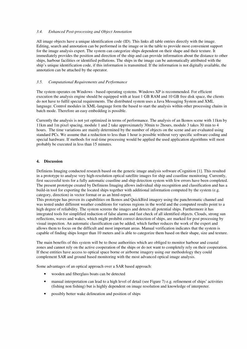
• manual interpretation can lead to a high level of detail (see Figure 7) e.g. refinement of ships’ activities
(fishing non fishing) but is highly dependent on image resolution and knowledge of interpreter.
• possibly better wake delineation and position of ships
Figure 7: Advantage of optical data over SAR data: high detail level. Ikonos data kindly provided by SpaceImaging, Europe
5. Conclusions and Outlook
The architecture of the described ship detection prototype allows various extensions to accommodate the needs of
the specific application and available database. The current prototype based on optical data is ready to be
embedded in a customer’s environment and the following descriptions should be regarded as examples for system
extensions giving an idea on possible customizations and system integrations.
5.1. Extensions concerning Sensor - Platform - Data
Synergy with SAR based ship and oil detection: The system can be embedded in ocean monitoring systems with
capabilities for ship detection based on SAR. The output of the SAR detection could be inserted into the system
and used for advanced categorization. Vice versa an integration of the analysis system in third party environment is
possible via XML as the control language and APIs as programming interfaces. Based on the convenient data
fusion capabilities of eCognition an integration of radar data would lead to a higher independency from weather
influences and could be of great benefit for further developments.
Extension with aerial surveys: the technology is built to combine data and information from different data sources.
This facilitates combining image information of different spatial resolution and ensures the efficient integration of
local aerial surveys with the analysis of large areas based on high, medium and low resolution satellite imagery.
In comparison to a surveillance solely based on aircraft it seems to be possible that cost can be reduced by a
combination of spaceborne and airborne data.
Exploration of multi-spectral channels: currently only the pan-chromatic channel is used for analysis to ensure
maximum data availability and avoid channel co-registration. However, for advanced analysis the multispectral
information will reduce ambiguities and thus increase the thematic accuracy.
Combination with other information: eCognition as underlying functionality allows in a customized version the
integration of weather information e.g. in Metars format. The information can be used to adapt the image analysis
and the detected objects can be attributed with the information as well. This might also be of special interest for oil
spill monitoring. Also the combination with any other available spatial information e.g. ocean maps (sea depth, sea
state), hurricane information or seismic information, visualization of planned ship routes, information from vessel
traffic systems of ports and from micro observing systems e.g. cameras, underwater acoustic instruments or
autonomous underwater vehicles is imaginable [3].
Object tracing and traffic vessel service: using multi-temporal images the system could give insight in the
frequentation of special areas over time. Once recognized, identified ships can be traced on their way from one
harbour to the next.
5.2. Refinement of Export – Interfaces - Interoperability
Advanced reporting: summarized reports on processing status and results will be accessible via WEB based
services and could also be sent with MMS or SMS to cell phones. The first solutions for WEB control of generic
eCognition software are in prototypical stage. This communication of image analysis results would enable a near
real time reaction of coastal authorities or masters of ships with minimum manual interaction.
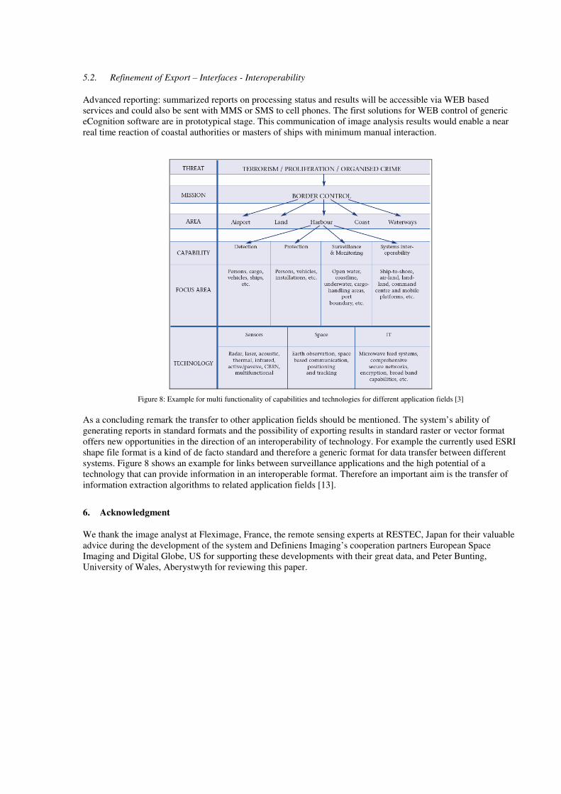
Figure 8: Example for multi functionality of capabilities and technologies for different application fields [3]
As a concluding remark the transfer to other application fields should be mentioned. The system’s ability of
generating reports in standard formats and the possibility of exporting results in standard raster or vector format
offers new opportunities in the direction of an interoperability of technology. For example the currently used ESRI
shape file format is a kind of de facto standard and therefore a generic format for data transfer between different
systems. Figure 8 shows an example for links between surveillance applications and the high potential of a
technology that can provide information in an interoperable format. Therefore an important aim is the transfer of
information extraction algorithms to related application fields [13].
6. Acknowledgment
We thank the image analyst at Fleximage, France, the remote sensing experts at RESTEC, Japan for their valuable
advice during the development of the system and Definiens Imaging’s cooperation partners European Space
Imaging and Digital Globe, US for supporting these developments with their great data, and Peter Bunting,
University of Wales, Aberystwyth for reviewing this paper.
References
[1]. Benz, U., Hofmann, P., Willhauck, G., Lingenfelder, I. and Heynen, M. (2004): Multi-resolution, object-
oriented fuzzy analysis of remote sensing data for GIS-ready information. In: ISPRS Journal of
Photogrammetry & Remote Sensing 58 (2004), 239-258.
[2]. DECLIMS project website http://fish.jrc.cec.eu.int/declims/
[3]. Dunham, S. (2004): Defending the Fleet in Harbour, Stevens Tech Studies Navy Antiterrorism and Force
Protection Measures. Journal of Homeland Security. http://www.homelandsecurity.org
[4]. European Commission (2004): Research for a Secure Europe, Report of the Group of Personalities in the field
of Security Research, Luxembourg: Office for Official Publications of the European Communities, 30 pp.,
ISBN 92-894-6611-1
[5]. European Comission (2004): The Common Fisheries Policy on the way to sustainability.
http://europa.eu.int/comm/fisheries/news_corner/press/inf04_37_en.htm
[6]. European Space Agency, Earth Observation Market Development (EOMD) Programme, Marine Surveillance
http://www.eomd.esa.int/booklets/booklet170.asp
[7]. EMSA (2004a): Ship Reporting. http://www.emsa.eu.int/end900d002d002.html
[8]. EMSA (2004b): Monitoring of Port State Control. http://www.emsa.eu.int/end900d002d007.html
[9]. Greidanus, H., Kourti, N., (2003): State of the art – Vessel Detection in SAR imagery. 2nd workshop Marine
SAR, EC / JRC DECLIMS - Detection and Classification of Marine Traffic from Space.
http://fish.jrc.cec.eu.int/declims/
[10]. IMO (2004): The International Ship and Port Facility Security Code.
http://www.imo.org/Newsroom/mainframe.asp?topic_id=583&doc_id=2689#code
[11]. Joanaz de Melo, J., Santana, P, (2000): A new model for EEZ surveillance and management in Portugal in
Brebbia, C. A, Pascolo, P.: Management Information Systems 2000; 2000 Jun 14-2000 Jun 16; Lisboa,
Portugal. United Kingdom: WIT Press; 2000: pp 103-111. 500 pp.
[12]. Kaminski, C., Wilkinson, B. (2004): Are U.S. Ports Safe? Earth Imaging Journal.
http://www.eijournal.com/USports.asp.
[13]. United Nations Convention on the Law of the Sea, UNCLOS, (1982), http://www.un.org/Depts/los/index.htm
[14]. Willhauck, G., Caliz, J.J., Hofmann, P., Benz. U., Heynen, M., Lingenfelder, I. (2004): Ship Detection and
Harbour Monitoring from VHR Satellite Imagery. In: GeoInformatics 8, Vol. 7 (2004), 6-9.