Embed Size (px)
Citation preview

The FEA-2107 and FEA-2807 are FURUNO’s new ECDIS
(Electronic Chart Display and Information System), which
have been designed to fully comply with the latest
standards and resolutions set by IMO, IHO and IEC.
The electronic chart is compatible with ENC (S57 Edition 3)
charts, C-Map CM93 ed3, C-MAP CM-ENC and ARCS
charts (RASTER CHARTS). Where the ENC chart is not
available, the ARCS chart is used instead. Instant
conversion is assured, as both chart databases are stored
on the ECDIS memory.
State-of-the-art technology has been utilized for high-speed
stress-free data processing of chart and navigational data,
which are overlaid on the chart. The navigational data
includes: AIS and ARPA targets as well as a variety of
other navigation information such as position, course, and
speed. In the presentation of chart data, faster chart
drawing and swift switching for presentation on/off of
navigational data can be performed. When planning
the voyage route, this gives quick route profile calculation
and voyage optimization and continuous monitoring of
huge navigational data, user actions and performance of
the system.
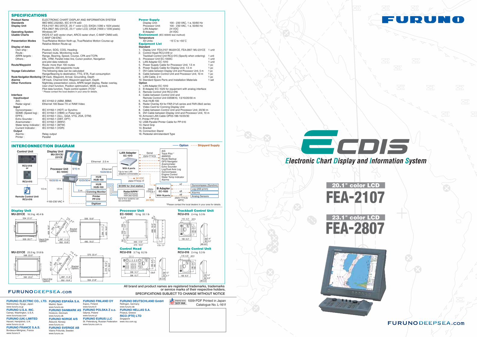
The FEA-2107/2807 can be interfaced with up to four sets
of radar/ARPA FAR-21x7/28x7 by using of 100 Base-T
Ethernet network. This allows high-speed data transfer and
data sharing for navigational data within the network, which
simplifies the system integration and the expandability of
the system. The shared data can be accepted in both serial
and analog format.
For the display units, the FEA-2107 uses a 20.1" SXGA
LCD and the FEA-2807 uses a 23.1" UXGA LCD. These
high-resolution units provide clear and sharp pictures for
comfortable observation. The presentation colors can be
selectable from five patterns according to the ambient
conditions of the bridge area for optimal viewing around
the clock. The ergonomically designed control panel
consisting of a keyboard, the trackball, thumbwheel and
mouse buttons facilitates intuitive and comfortable operation.Electronic Chart Display and Information System
FEA-2107: 20.1" LCD
With optional mounting bracket and connection stand
FEA-2807: 23.1" LCD
O b t a i n c r i t i c a l n a v i g a t i o n i n f o r m a t i o n o n a s t a t e - o f - t h e - a r t E C D I S f o r s a f e a n d e f f i c i e n t t r a v e l s
With optional pedestal

Ethernet 100 Base-TX
GP-150 FE-700
DS-50
F E A T U R E S o f E C D I S
ENC IHO S57 Edition 3
Optional pedestal
sThe electronic chart can be overlaid with a variety of navigation data such as Radar echo images, ship’s position, heading, speed and others to facilitate safe and efficient navigation.
sComplies with the following IMO and IEC regulations:• IMO MSC.232(82) • IMO A.694(17)• IEC 61174 edition 3 • IEC 60945 edition 4• IEC 61162-1 edition 2 • IEC 61162-2 edition 1
sCompatible with ENC (S-57 Edition 3) charts, ARCS charts, C-MAP CM93 ed3 and C-MAP CM-ENC
sFlexible expandability allows the ECDIS to be networked with radar/ARPA, positioning equipment, autopilot and others to consolidate the navigation system
sUser-customizable chart drawing function
sRoute planning applicable to both Mercator’s sailing and great-circle sailing
sTrack Control System when connected with autopilot (Option)
sNavigation data for the past 12 hours can be recorded(The data to be recorded includes: time, ship’s position, GPS correction data, ship’s heading, ship’s speed)
sTrue Motion and Relative Motion modes are available
sErgonomically designed control panel provides ease-of-useThe ergonomically designed control panel consists of a trackball, a thumbwheel and a keyboard. The logically arranged keyboard provides intuitive operation. Optionally, the compact control head only with a trackball and a thumbwheel is available for space-saving installation.
sNavigation data is shared within an Ethernet networkThe 100 Base-T Ethernet is utilized to link this ECDIS with up to four sets of radar/ARPA FAR-21x7/28x7. This link gives high-speed navigational data sharing within the system and allows operators to choose either a single station system or a total Integrated Navigation System (INS).
sHigh-resolution color LCDThe use of 20.1"/23.1" high-resolution SXGA/UXGA LCDs provide crystal clear presentations of navigation information, such as marks, lines and waypoints. The LCDs also allows for installation where space is limited.
sDisplays 200 AIS targetsWhen connected to an optional AIS transponder, the FEA-2107/2807 can store up to 1,000 AIS targets information in its storage buffer, and displays up to 200 AIS targets within the user-defined range on the display. This provides operators with another solution for observation of other craft.
sStreamlined designThe color scheme of the optional pedestal is a stylish pearl white and gray. The streamline design fits perfectly in the modern bridge.
A f l e x i b l e E t h e r n e t n e t w o r k a l l o w s f o r f u t u r e e x p a n d a b i l i t y
Palm control unit
Sleeping AIS Target Activated Target Lost Target Dangerous TargetSelected Target

P R E S E N T A T I O N S o f E C D I S
Route planningThe operators can plan and determine the precise route with ease, while studying the chart data on the screen. A route can be altered in minute detail, and the changed route can be saved for later use.
Radar overlayRadar echo image overlay is optionally available in the FEA-2107/2807. This function gives the exact match in scale and presentation of the chart and radar echo image. This greatly helps the operator’s observation and enhances operators’ decision-making process.
A variety of navigation information, which is input from up to sixteen onboard sensors, can be graphically displayed on thee screen. Up to eight sensors provide the analog data, and the other eight provide the serial data. The information is displayed in six predefined place where the operators can arrange the layout.
Conning display
Typically, information on the conning display is received from the following sensors:
Data displayWhen the cursor is placed upon any mark on the electronic chart, related information about the object such as a buoy, lighthouse, sunken vessel, etc., will be shown in the data cell. Additionally, other navigational information including both own ship’s navigational as well as other ship’s information from ARPA can also be presented.
This function informs the operator beforehand of shallow coastal water and other sea conditions that could contribute to the ship going aground. The information about the sea areas is acquired from the electronic chart and ship’s draft data is preset in own ship’s information so that possible strand can be avoided.
Antigrounding
N a v i g a t e s a f e l y a n d e f f i c i e n t l y w i t h t h e E C D I S r o u t e p l a n n i n g a n d m o n i t o r i n g
sPosition sensorssWind sensorsGyro
sRate of turn gyrosLog/Dual-axis logsEcho sounder
sRuddersPropellerssThrusters
Radar overlay dialog boxOperators can have controls for adjustment of the radar image - gain, sea clutter, rain clutter, echo trail, interference rejector, echo stretch and noise rejector.
AIS symbol
Own ship’s marker
Heading
Planned route
WTP(Waypoint)
Buoy
Status bar• Presentation mode• Operation Mode• Chart Scale• Data displayed
Own ship’s information• Heading• Speed• Course over ground (COG)• Speed over ground (SOG)• Own ship's position
AIS information• Name • Course• IMO MMSI number • CPA• TCPA • Position• Speed • range, etc.