Embed Size (px)
Citation preview
Continental Shelf Research 53 (2013) 89–101
Contents lists available at SciVerse ScienceDirect
Continental Shelf Research
0278-43
http://d
n Corr
E-m
journal homepage: www.elsevier.com/locate/csr
Research papers
Ocean dynamics and anthropogenic impacts along the southern Black Seashelf examined through the preservation of pre-modern shipwrecks
Michael L. Brennan a,n, Dan Davis b, Chris Roman a,c, Ilya Buynevich d, Alexis Catsambis e, Meko Kofahl e,Derya Urkmez f, J. Ian Vaughn c, Maureen Merrigan e, Muhammet Duman g
a Graduate School of Oceanography, University of Rhode Island, Narragansett, RI 02882, USAb Department of Classics, Luther College, Decorah, IA 52101, USAc Department of Ocean Engineering, University of Rhode Island, Narragansett, RI 02882, USAd Department of Earth and Environmental Science, Temple University, Philadelphia, PA 19122, USAe Department of Anthropology, Texas A&M University, College Station, TX 77843, USAf Department of Hydrobiology, University of Sinop, Turkeyg Institute of Marine Science and Technology, Dokuz Eylul University, Izmir, Turkey
a r t i c l e i n f o
Article history:
Received 24 June 2012
Received in revised form
28 November 2012
Accepted 18 December 2012Available online 27 December 2012
Keywords:
Black Sea
Shipwrecks
Trawling
Suboxic zone
Internal waves
43/$ - see front matter & 2012 Elsevier Ltd. A
x.doi.org/10.1016/j.csr.2012.12.010
esponding author. Tel.: þ1 401 874 6186.
ail address: [email protected] (M.L. Bre
a b s t r a c t
Continued exploration of the coastal area of the southern Black Sea off Sinop and Eregli, Turkey in 2011
expanded our current understanding of the transition zone along the oxic/anoxic interface. Push cores
collected with an ROV in sediments underlying the oxic, suboxic, and anoxic waters were analyzed for
geochemistry, meiofauna, and microbiology to help characterize this transition zone. During the course
of side-scan sonar surveys, nine shipwrecks were located in various states of preservation, all within
100–115 m depth and ranging from the 4th century B.C. to the early 20th century. Many of these
wrecks have wooden components well preserved due to the influences of anoxic waters being washed
up along the shelf by internal waves. However, a number of these sites have been heavily damaged by
bottom trawling along the seabed up to the shelf break, highlighting the persistent threat such
activities pose to submerged archaeological sites.
& 2012 Elsevier Ltd. All rights reserved.
1. Introduction
The Black Sea has long been hypothesized to be a repository ofwell-preserved cultural material due to anoxic conditions below�155 m depth (e.g., Bascom, 1976). Sinop D, a well-preservedByzantine shipwreck discovered in 2000 and subsequently inves-tigated in 2003 and 2007, illustrates the potential for wreckpreservation in the deep waters of the Black Sea (Ballard et al.,2001; Ward and Ballard, 2004; Brennan et al., 2011). Furtheracoustic mapping and exploration of the Turkish continental shelfof the southern Black Sea in 2011 aimed to document the land-scape across the oxic/anoxic interface between 100 and 300 mdepth and map the extent and intensity of bottom trawling in theregion. Push cores were collected from the sediments underlyingthe oxic, suboxic, and anoxic waters to evaluate these differingenvironments for geochemical and biological processes. Thesurvey also resulted in the discovery and non-instrusive assess-ment of nine pre-modern era shipwrecks at depths ranging from100 to 115 m, several of which exhibit better than expected
ll rights reserved.
nnan).
preservation at this shallow depth above the traditionally under-stood anoxic boundary (Fig. 1). The location of these shipwrecksites provides an additional perspective on our current under-standing of the dynamics of the oxic/anoxic interface. Thepreservation of the wood timbers in oxic waters suggests thatdensity currents may be episodically introducing anoxic water upand onto the shelf to depths shallower than previously expected,thereby periodically preventing planktonic larvae of wood-boringbivalves from settling on the wreck sites. Additionally, the variousstates of damage and disarticulation of wooden timbers on someof these wrecks illustrate past and present operations of bottomtrawlers up to and below the chemocline.
1.1. Oceanographic context
The suboxic zone of the Black Sea is a recent discovery, and thedynamics of this mixed layer are poorly understood. The low-salinity surface water from riverine input that overlies the dense,higher-salinity water from the Mediterranean creates a strongstratification in the Black Sea. A series of cruises on R/V Knorr in1988 studied the oxic/anoxic interface and found a gap betweenthe depletion of dissolved oxygen (O2) and the onset of hydrogensulfide (H2S), instead of a layer where these overlap, as noted
Fig. 1. Map of the Black Sea showing survey locations off Eregli and Sinop, Turkey. Bathymetry data (in m) from the GEBCO_08 Grid, version 20091120, http://www.gebco.net.
M.L. Brennan et al. / Continental Shelf Research 53 (2013) 89–10190
during cruises in 1969 and 1975 (Murray et al., 1989). Theseearlier cruises found a constant density along which oxygen wasdepleted to zero, creating a dome-shaped layer ranging from115 m depth in the middle of the basin and down to 275 m nearthe continental shelf. Observations made in 1988 revealed a gapof 10–40 m between the oxic and anoxic layers, and a rise in theboundary of the anoxic zone (Murray et al., 1989). More recentresearch has shown that, prior to 1988, results suggesting acoexistence of O2 and H2S were an artifact of atmosphericcontamination of the instruments, and that the transitionalsuboxic zone is a permanent feature in the vertical hydrologicalstructure of the Black Sea (Glazer et al., 2006b). Furthermore, notonly is the suboxic zone a barrier between the coexistence of O2
and H2S, but O2 cannot be the oxidant for sulfide, as they do notinteract while cycling through the water column. The mechanismfor sulfide oxidation may instead be ferromanganese-oxides thattransport oxygen across the suboxic gap (e.g., Glazer et al., 2006a,2006b; Murray et al., 2007; Trouwborst et al., 2006).
The research presented here is a continuation of work begun in1998 by the Institute for Exploration (IFE). Ryan et al. (1997)proposed a catastrophic flood of the Black Sea’s isolated Quatern-ary freshwater lake 9000 years ago, beginning the transformationof the Black Sea into a euxinic basin. The restricted outflow at theshallow Bosporus sill has since caused the stratification of theBlack Sea by retaining the dense, saline Mediterranean waterswithin the basin, thereby creating a stagnant, anoxic layer. Thefirst IFE expeditions in 1998 and 1999 surveyed the shelf area eastof Sinop, Turkey (Fig. 1) and documented what was interpreted asthe paleoshoreline at the 155 m isobath (Ballard et al., 2001;Coleman and Ballard, 2004). This relict beach was characterizedby rocks rounded by beach erosional processes as well asHolocene freshwater mollusk shells (Ballard et al., 2001). Furtherwork in 2000 continued these surveys west of Sinop and resultedin the discovery of four early Byzantine shipwrecks, three (SinopA–C) at �100 m depth, and Sinop D at 325 m, which wasinvestigated further with test excavations in 2003 and 2007(Ward and Ballard, 2004; Ward and Horlings, 2008; Brennanet al., 2011). Sinop A, B, and C consist of mounds of exposedcarrot-shaped amphorae, which are of a type commonly found at
kiln sites near Sinop (Ward and Ballard, 2004). Sinop A and C aresmaller sites, consisting of two and three piles of artifactsrespectively, whereas Sinop B is a single, larger and consolidatedsite. Also, B contains a variety of ceramic types, whereas A and Ccontain only the carrot-shaped amphorae. A small number ofwooden timbers were identified on each wreck, but the majorityof the ships’ structural elements are not preserved. These wrecks,however, have more preserved wood than is found on contem-porary amphora wrecks in the Mediterranean and Aegean Seas.This phenomenon was thought to be due to fluctuations in anoxicwaters moving up onto the shelf (Ward and Horlings, 2008).
Ballard et al. (2001) initially suggested that internal wavesdrive anoxic waters up along the shelf and help preserve somewooden components of the Sinop A, B, and C wrecks. The densitygradient between the oxic and anoxic water layers is great enoughto support the propagation of internal waves (Trembanis et al.,2011). The thermohaline structure of the Black Sea is affected byoceanographic processes, such as storms and thermic frontscaused by surges at river mouths and the Bosporus outflow, allof which transmit energy through the halocline in the form ofdensity currents, or internal waves (Filonov, 2000). These eventsremain poorly understood, although they have been observed offthe Crimean peninsula (Filonov, 2000). The dynamics of thisinterface is of particular interest with respect to the preservationpotential of cultural sites as the effects of these waves may helppreserve wrecks at shallower depths than previously thought(Ballard et al., 2001; Trembanis et al., 2011). The depth of theanoxic layer varies, but is generally in the range of thepaleoshoreline at 155 m. When waves traveling through theinterface between water layers of different densities interact withthe continental shelf, they break across it similar to surface waveson a beach (Trembanis et al., 2011). The slope of the continentalshelf will affect how far the waves will wash anoxic water toshallower depths; the slope in the area west of Sinop is moregradual than off Crimea, for example. Near Sinop, Duman et al.(2006) show that the permanent halocline exists at 100–110 mdepth, while the transitional suboxic layer extends down from100 m to �200 m, at which point the anoxic layer begins. It isexpected, therefore, that within this transitional zone from 100 to
M.L. Brennan et al. / Continental Shelf Research 53 (2013) 89–101 91
200 m depth, and possibly even shallower, shipwrecks should befound in a better state of preservation than those in oxygenatedwaters. Two such areas are located along the southern Black Seacoast near respective cities that thrived as maritime powersduring antiquity and the Byzantine period, Heraclea Pontica(modern Eregli) and Sinope (modern Sinop).
1.2. Historical context
Between their foundations in the Archaic period until theMiddle Ages, ancient Sinope and Heraclea Pontica ranked amongthe Black Sea’s most active trading powers. Both cities possessedrich fishing grounds, fertile coastal plains, and abundant forests.Sinope with its twin natural harbors lies midway along thesouthern coast from the entrance to the Black Sea and at theclosest crossing point to the northern shore. The city was foundedby Greeks from the Ionian city of Miletus in the late 7th centuryB.C. (Strabo, 12.3.11; Hind, 1988; Doonan, 2004; Avram et al.,2004). Early on the city itself founded three colonies on this shoreand became one of the region’s major trading powers, serving asan important node in a dense network of seaborne trade. The soilon the promontory encouraged the production of wine and oliveoil, which it exported for centuries in large quantities in dis-tinctive amphorae, and the densely-forested hinterland producedtimber perfectly suited to ship-building. Throughout the Romanand Byzantine periods the city’s fortunes waxed and waned,depending on military and political movements in and aroundthe Black Sea region. Evidence of Sinope’s prosperity is difficult todetect in the archaeological record because the ancient city liesdirectly below the modern one. Based on the quantities ofSinopean amphorae found at sites around the Black Sea; however,the city exported goods extensively during the Hellenistic, Romanand Early Byzantine periods (Doonan, 2004; Opait, 2010b).
Heraclea Pontica, located on a bay near a projecting headlandmidway between the Bosporus and Sinop, was founded by Greeksettlers around the mid-6th century B.C. (Saprykin, 1997; Avramet al., 2004). Like Sinope, Heraclea’s vast hinterland producedolive oil and wine for export, and local forests furnished timberfor ship construction. The city lies just a long day’s sail from theBosporus (Xenophon, Anabasis 6.4.2) and near the southern end ofa natural maritime corridor that spanned the shortest distanceacross the open sea between Cape Carambis (halfway betweenHeraclea and Sinope) and Criumetopon, the southernmost pointof the Crimea, near to which Heraclean settlers founded Cherso-nesos in the 5th century B.C. Although archaeological research ofHeraclea has been minimal (as in the case of Sinop, modern Ereglilies atop the ancient city), numerous literary sources attest to thecity’s commercial prosperity during the Classical and Hellenisticperiods (Burstein, 1976; Saprykin, 1997; Avram et al., 2004). Thecity and its rulers grew wealthy from harbor and market tollsexacted from the grain ships that touched this coast en route tothe Bosporus and beyond to other Aegean centers, mostnotably Athens (Isager and Hansen, 1975; Burstein, 1976). Her-aclean amphorae have been discovered in coastal and inlandsites all over the Black Sea region, particularly at Chersonesos.Heraclea waned during the Roman period, losing territory andpower to its neighbors to the east and west, but the citymaintained some level of influence and regional connections intomedieval times.
In addition to the three shipwrecks discovered at 100–115 mdepth off Sinop in 2000, another four were found nearby in thesame depth range in 2011, and five more were located west ofEregli. The investigation of the twelve shipwrecks found withinthis transitional suboxic zone between 2000 and 2011 is indica-tive of the thermohaline dynamics that have affected the sitessince the time of the ships’ sinking. The Black Sea serves as an
ideal natural laboratory for applied archaeological oceanography,as the investigation of shipwrecks gives us the opportunity to usethese sites as platforms from which to learn about the oceano-graphic environment (Brennan and Ballard, in press; Brennanet al., 2011). The objectives of this research off the Turkish BlackSea coast were to document the dynamics of the oxic/anoxicinterface on the coastal shelf and anthropogenic impacts, espe-cially bottom trawl fishing. Further investigations of these twoaspects of the submarine landscape will in turn allow us tounderstand the effects of both internal waves and trawl damageon the preservation and degradation of shipwreck sites. Thetwelve wrecks located in this zone are disarticulated to varyingdegrees and in most cases reflects the extent and intensity oftrawling activities in the immediate region. Additionally, based onthe preservation state of these shipwrecks at such shallow depths,we postulate that internal wave action washes water from thesulfidic zone up across shallow-gradient shelves, such as thatalong the coastal zone off Sinop, frequently enough to impede thedegradation of wooden ships by wood-boring organisms.
2. Methods
2.1. Side-scan sonar
A series of grids were surveyed off Eregli and Sinop, Turkey inJuly–August 2011 on E/V Nautilus (Fig. 1). These survey areasalong regions of the Turkish continental shelf were selected eitherbecause the slope was gentle enough to conduct effective sonaroperations, such as off Sinop, or because the shelf formed aplateau, such as west of Eregli. The goal of placing these surveyswas to document the seabed morphology of areas of the shelfbetween 100 and 300 m depth, which cross the oxic/anoxicinterface. An EdgeTech 4200-MP dual frequency (300/600 kHz)high resolution side-scan sonar was towed behind the ship alongsystematic survey lines with a 300 m swath width. Slope failures,slumps, bedforms, trawl scars, and other targets were loggedduring the surveys. As these areas are in proximity to theancient sites of Heraclea and Sinop, we also expected that someof the targets located with sonar would be shipwrecks, theinvestigation of which would allow for the evaluation of theeffects of both the water column dynamics and trawl damage tothese sites. The side-scan sonar data were imported intoand processed with CARIS HIPS and SIPS. The lines were viewedin 300�300 m patches, and trawl scars on the seabed werecounted per unit area. These were used to create trawl intensitymaps for both regions (e.g., DeAlteris et al., 1999; Brennan et al.,2012).
2.2. ROV operations
Target identification, side-scan sonar ground-truthing, and sedi-ment core collection was conducted with remotely operated vehicles(ROVs) Hercules and Argus (Newman et al., 2008; Brennan et al.,2012). Hercules is equipped with a suite of sensors, including anAanderaa optode for dissolved oxygen and a Falmouth Scientific CTDfor conductivity, temperature, and depth measurements. These sensordata were processed with Matlab to create water column profiles fortemperature, salinity, and dissolved oxygen. The vehicle is equippedwith push core tubes with which the manipulator arm can collectsediment samples. Ten push cores were collected from three locationsoff Sinop. Six cores were collected at 203 m depth in the anoxic layerfor textural, microbiological, meiofaunal, and porewater geochemistryanalyses. Two cores were collected at 90 m in the oxic layer andanother two at 120 m in the suboxic layer for microbiology andmeiofaunal analyses. The location for the suboxic cores was
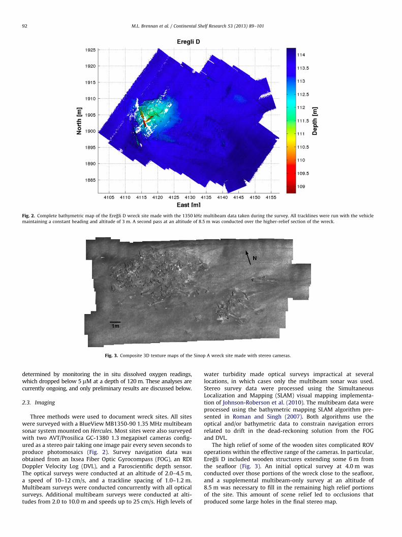
Fig. 2. Complete bathymetric map of the Eregli D wreck site made with the 1350 kHz multibeam data taken during the survey. All tracklines were run with the vehicle
maintaining a constant heading and altitude of 3 m. A second pass at an altitude of 8.5 m was conducted over the higher-relief section of the wreck.
Fig. 3. Composite 3D texture maps of the Sinop A wreck site made with stereo cameras.
M.L. Brennan et al. / Continental Shelf Research 53 (2013) 89–10192
determined by monitoring the in situ dissolved oxygen readings,which dropped below 5 mM at a depth of 120 m. These analyses arecurrently ongoing, and only preliminary results are discussed below.
2.3. Imaging
Three methods were used to document wreck sites. All siteswere surveyed with a BlueView MB1350-90 1.35 MHz multibeamsonar system mounted on Hercules. Most sites were also surveyedwith two AVT/Prosilica GC-1380 1.3 megapixel cameras config-ured as a stereo pair taking one image pair every seven seconds toproduce photomosaics (Fig. 2). Survey navigation data wasobtained from an Ixsea Fiber Optic Gyrocompass (FOG), an RDIDoppler Velocity Log (DVL), and a Paroscientific depth sensor.The optical surveys were conducted at an altitude of 2.0–4.5 m,a speed of 10–12 cm/s, and a trackline spacing of 1.0–1.2 m.Multibeam surveys were conducted concurrently with all opticalsurveys. Additional multibeam surveys were conducted at alti-tudes from 2.0 to 10.0 m and speeds up to 25 cm/s. High levels of
water turbidity made optical surveys impractical at severallocations, in which cases only the multibeam sonar was used.Stereo survey data were processed using the SimultaneousLocalization and Mapping (SLAM) visual mapping implementa-tion of Johnson-Roberson et al. (2010). The multibeam data wereprocessed using the bathymetric mapping SLAM algorithm pre-sented in Roman and Singh (2007). Both algorithms use theoptical and/or bathymetric data to constrain navigation errorsrelated to drift in the dead-reckoning solution from the FOGand DVL.
The high relief of some of the wooden sites complicated ROVoperations within the effective range of the cameras. In particular,Eregli D included wooden structures extending some 6 m fromthe seafloor (Fig. 3). An initial optical survey at 4.0 m wasconducted over those portions of the wreck close to the seafloor,and a supplemental multibeam-only survey at an altitude of8.5 m was necessary to fill in the remaining high relief portionsof the site. This amount of scene relief led to occlusions thatproduced some large holes in the final stereo map.
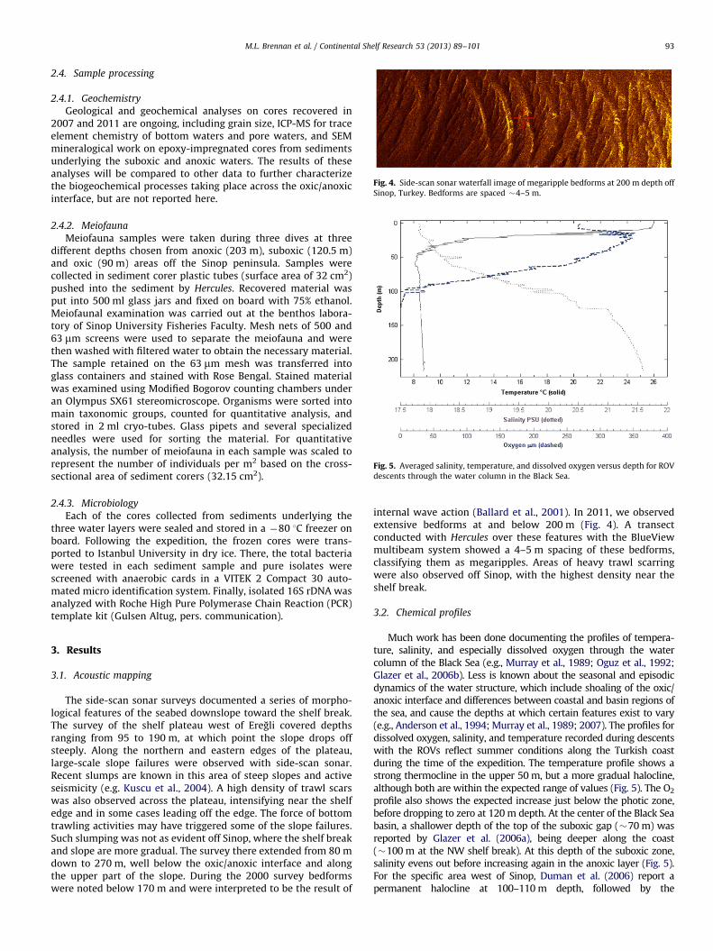
Fig. 4. Side-scan sonar waterfall image of megaripple bedforms at 200 m depth off
Sinop, Turkey. Bedforms are spaced �4–5 m.
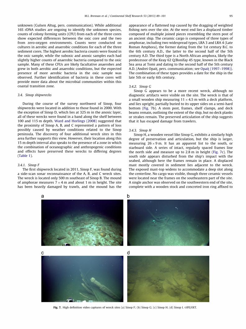
Fig. 5. Averaged salinity, temperature, and dissolved oxygen versus depth for ROV
descents through the water column in the Black Sea.
M.L. Brennan et al. / Continental Shelf Research 53 (2013) 89–101 93
2.4. Sample processing
2.4.1. Geochemistry
Geological and geochemical analyses on cores recovered in2007 and 2011 are ongoing, including grain size, ICP-MS for traceelement chemistry of bottom waters and pore waters, and SEMmineralogical work on epoxy-impregnated cores from sedimentsunderlying the suboxic and anoxic waters. The results of theseanalyses will be compared to other data to further characterizethe biogeochemical processes taking place across the oxic/anoxicinterface, but are not reported here.
2.4.2. Meiofauna
Meiofauna samples were taken during three dives at threedifferent depths chosen from anoxic (203 m), suboxic (120.5 m)and oxic (90 m) areas off the Sinop peninsula. Samples werecollected in sediment corer plastic tubes (surface area of 32 cm2)pushed into the sediment by Hercules. Recovered material wasput into 500 ml glass jars and fixed on board with 75% ethanol.Meiofaunal examination was carried out at the benthos labora-tory of Sinop University Fisheries Faculty. Mesh nets of 500 and63 mm screens were used to separate the meiofauna and werethen washed with filtered water to obtain the necessary material.The sample retained on the 63 mm mesh was transferred intoglass containers and stained with Rose Bengal. Stained materialwas examined using Modified Bogorov counting chambers underan Olympus SX61 stereomicroscope. Organisms were sorted intomain taxonomic groups, counted for quantitative analysis, andstored in 2 ml cryo-tubes. Glass pipets and several specializedneedles were used for sorting the material. For quantitativeanalysis, the number of meiofauna in each sample was scaled torepresent the number of individuals per m2 based on the cross-sectional area of sediment corers (32.15 cm2).
2.4.3. Microbiology
Each of the cores collected from sediments underlying thethree water layers were sealed and stored in a �80 1C freezer onboard. Following the expedition, the frozen cores were trans-ported to Istanbul University in dry ice. There, the total bacteriawere tested in each sediment sample and pure isolates werescreened with anaerobic cards in a VITEK 2 Compact 30 auto-mated micro identification system. Finally, isolated 16S rDNA wasanalyzed with Roche High Pure Polymerase Chain Reaction (PCR)template kit (Gulsen Altug, pers. communication).
3. Results
3.1. Acoustic mapping
The side-scan sonar surveys documented a series of morpho-logical features of the seabed downslope toward the shelf break.The survey of the shelf plateau west of Eregli covered depthsranging from 95 to 190 m, at which point the slope drops offsteeply. Along the northern and eastern edges of the plateau,large-scale slope failures were observed with side-scan sonar.Recent slumps are known in this area of steep slopes and activeseismicity (e.g. Kuscu et al., 2004). A high density of trawl scarswas also observed across the plateau, intensifying near the shelfedge and in some cases leading off the edge. The force of bottomtrawling activities may have triggered some of the slope failures.Such slumping was not as evident off Sinop, where the shelf breakand slope are more gradual. The survey there extended from 80 mdown to 270 m, well below the oxic/anoxic interface and alongthe upper part of the slope. During the 2000 survey bedformswere noted below 170 m and were interpreted to be the result of
internal wave action (Ballard et al., 2001). In 2011, we observedextensive bedforms at and below 200 m (Fig. 4). A transectconducted with Hercules over these features with the BlueViewmultibeam system showed a 4–5 m spacing of these bedforms,classifying them as megaripples. Areas of heavy trawl scarringwere also observed off Sinop, with the highest density near theshelf break.
3.2. Chemical profiles
Much work has been done documenting the profiles of tempera-ture, salinity, and especially dissolved oxygen through the watercolumn of the Black Sea (e.g., Murray et al., 1989; Oguz et al., 1992;Glazer et al., 2006b). Less is known about the seasonal and episodicdynamics of the water structure, which include shoaling of the oxic/anoxic interface and differences between coastal and basin regions ofthe sea, and cause the depths at which certain features exist to vary(e.g., Anderson et al., 1994; Murray et al., 1989; 2007). The profiles fordissolved oxygen, salinity, and temperature recorded during descentswith the ROVs reflect summer conditions along the Turkish coastduring the time of the expedition. The temperature profile shows astrong thermocline in the upper 50 m, but a more gradual halocline,although both are within the expected range of values (Fig. 5). The O2
profile also shows the expected increase just below the photic zone,before dropping to zero at 120 m depth. At the center of the Black Seabasin, a shallower depth of the top of the suboxic gap (�70 m) wasreported by Glazer et al. (2006a), being deeper along the coast(�100 m at the NW shelf break). At this depth of the suboxic zone,salinity evens out before increasing again in the anoxic layer (Fig. 5).For the specific area west of Sinop, Duman et al. (2006) report apermanent halocline at 100–110 m depth, followed by the
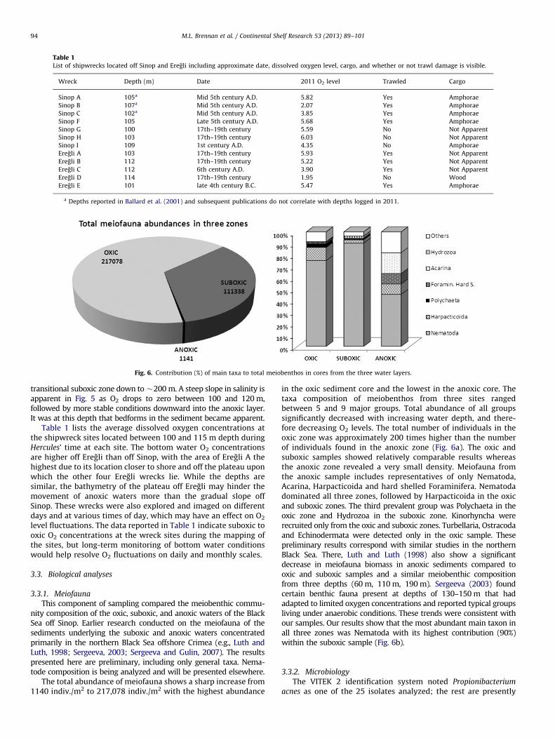
Table 1List of shipwrecks located off Sinop and Eregli including approximate date, dissolved oxygen level, cargo, and whether or not trawl damage is visible.
Wreck Depth (m) Date 2011 O2 level Trawled Cargo
Sinop A 105a Mid 5th century A.D. 5.82 Yes Amphorae
Sinop B 107a Mid 5th century A.D. 2.07 Yes Amphorae
Sinop C 102a Mid 5th century A.D. 3.85 Yes Amphorae
Sinop F 105 Late 5th century A.D. 5.68 Yes Amphorae
Sinop G 100 17th–19th century 5.59 No Not Apparent
Sinop H 103 17th–19th century 6.03 No Not Apparent
Sinop I 109 1st century A.D. 4.35 No Amphorae
Eregli A 103 17th–19th century 5.93 Yes Not Apparent
Eregli B 112 17th–19th century 5.22 Yes Not Apparent
Eregli C 112 6th century A.D. 3.90 Yes Not Apparent
Eregli D 114 17th–19th century 1.95 No Wood
Eregli E 101 late 4th century B.C. 5.47 Yes Amphorae
a Depths reported in Ballard et al. (2001) and subsequent publications do not correlate with depths logged in 2011.
Fig. 6. Contribution (%) of main taxa to total meiobenthos in cores from the three water layers.
M.L. Brennan et al. / Continental Shelf Research 53 (2013) 89–10194
transitional suboxic zone down to �200 m. A steep slope in salinity isapparent in Fig. 5 as O2 drops to zero between 100 and 120 m,followed by more stable conditions downward into the anoxic layer.It was at this depth that bedforms in the sediment became apparent.
Table 1 lists the average dissolved oxygen concentrations atthe shipwreck sites located between 100 and 115 m depth duringHercules’ time at each site. The bottom water O2 concentrationsare higher off Eregli than off Sinop, with the area of Eregli A thehighest due to its location closer to shore and off the plateau uponwhich the other four Eregli wrecks lie. While the depths aresimilar, the bathymetry of the plateau off Eregli may hinder themovement of anoxic waters more than the gradual slope offSinop. These wrecks were also explored and imaged on differentdays and at various times of day, which may have an effect on O2
level fluctuations. The data reported in Table 1 indicate suboxic tooxic O2 concentrations at the wreck sites during the mapping ofthe sites, but long-term monitoring of bottom water conditionswould help resolve O2 fluctuations on daily and monthly scales.
3.3. Biological analyses
3.3.1. Meiofauna
This component of sampling compared the meiobenthic commu-nity composition of the oxic, suboxic, and anoxic waters of the BlackSea off Sinop. Earlier research conducted on the meiofauna of thesediments underlying the suboxic and anoxic waters concentratedprimarily in the northern Black Sea offshore Crimea (e.g., Luth andLuth, 1998; Sergeeva, 2003; Sergeeva and Gulin, 2007). The resultspresented here are preliminary, including only general taxa. Nema-tode composition is being analyzed and will be presented elsewhere.
The total abundance of meiofauna shows a sharp increase from1140 indiv./m2 to 217,078 indiv./m2 with the highest abundance
in the oxic sediment core and the lowest in the anoxic core. Thetaxa composition of meiobenthos from three sites rangedbetween 5 and 9 major groups. Total abundance of all groupssignificantly decreased with increasing water depth, and there-fore decreasing O2 levels. The total number of individuals in theoxic zone was approximately 200 times higher than the numberof individuals found in the anoxic zone (Fig. 6a). The oxic andsuboxic samples showed relatively comparable results whereasthe anoxic zone revealed a very small density. Meiofauna fromthe anoxic sample includes representatives of only Nematoda,Acarina, Harpacticoida and hard shelled Foraminifera. Nematodadominated all three zones, followed by Harpacticoida in the oxicand suboxic zones. The third prevalent group was Polychaeta in theoxic zone and Hydrozoa in the suboxic zone. Kinorhyncha wererecruited only from the oxic and suboxic zones. Turbellaria, Ostracodaand Echinodermata were detected only in the oxic sample. Thesepreliminary results correspond with similar studies in the northernBlack Sea. There, Luth and Luth (1998) also show a significantdecrease in meiofauna biomass in anoxic sediments compared tooxic and suboxic samples and a similar meiobenthic compositionfrom three depths (60 m, 110 m, 190 m). Sergeeva (2003) foundcertain benthic fauna present at depths of 130–150 m that hadadapted to limited oxygen concentrations and reported typical groupsliving under anaerobic conditions. These trends were consistent withour samples. Our results show that the most abundant main taxon inall three zones was Nematoda with its highest contribution (90%)within the suboxic sample (Fig. 6b).
3.3.2. Microbiology
The VITEK 2 identification system noted Propionibacterium
acnes as one of the 25 isolates analyzed; the rest are presently
M.L. Brennan et al. / Continental Shelf Research 53 (2013) 89–101 95
unknown (Gulsen Altug, pers. communication). While additional16S rDNA studies are ongoing to identify the unknown species,counts of colony forming units (CFU) from each of the three coresshow expected differences between the oxic core and the twofrom zero-oxygen environments. Counts were conducted oncultures in aerobic and anaerobic conditions for each of the threesediment cores. The highest aerobic bacteria counts were found inthe oxic sample, while the suboxic and anoxic samples each hadslightly higher counts of anaerobic bacteria compared to the oxicsample. Many of these CFUs are likely facultative anaerobes andgrew in both aerobic and anaerobic conditions, but the expectedpresence of more aerobic bacteria in the oxic sample wasobserved. Further identification of bacteria in these cores willprovide more data about the microbial communities within thiscoastal transition zone.
3.4. Sinop shipwrecks
During the course of the survey northwest of Sinop, fourshipwrecks were located in addition to those found in 2000. Withthe exception of Sinop D, which lies at 325 m in the anoxic layer,all of these wrecks were found in a band along the shelf between100 and 115 m depth. Ward and Horlings (2008) suggested thatthe proximity of Sinop A, B, and C represented a pattern of losspossibly caused by weather conditions related to the Sinoppeninsula. The discovery of four additional wreck sites in thisarea further supports this view. However, their location along this15 m depth interval also speaks to the presence of a zone in whichthe combination of oceanographic and anthropogenic conditionsand effects have preserved these wrecks to differing degrees(Table 1).
3.4.1. Sinop F
The first shipwreck located in 2011, Sinop F, was found duringa side-scan sonar reconnaissance of the A, B, and C wreck sites.The wreck is located only 500 m southeast of Sinop B. The moundof amphorae measures 7�4 m and about 1 m in height. The sitehas been heavily damaged by trawls, and the mound has the
Fig. 7. High definition video captures of wreck sites (a) Sin
appearance of a flattened top caused by the dragging of weightedfishing nets over the site. At the west end lies a displaced timbercomposed of multiple joined pieces resembling the stern post ofan ancient ship. The ceramic cargo is composed of three types ofamphorae, including two widespread types, LRA 3 and LRA 4 (LateRoman Amphora), the former dating from the 1st century B.C. tothe 6th century A.D., the latter to the second half of the 5thcentury A.D. The third type is a North African amphora, likely thepredecessor of the Keay 62 Q/Bonifay 45 type, known in the BlackSea area at Tomi and dating to the second half of the 5th centuryA.D. (Andrei Opait, pers. communication; see Opait (1997–1998)).The combination of these types provides a date for the ship in thelate 5th or early 6th century.
3.4.2. Sinop G
Sinop G appears to be a more recent wreck, although nodiagnostic artifacts were visible on the site. The wreck is that ofa small wooden ship measuring 11�4.5 m with a deck platform,and lies upright, partially buried to its upper sides on a semi-hardbottom (Fig. 7b). A stem post, frames, shelf clamps, and deckbeams remain, outlining the extent of the ship, but no deck planksor strakes remain. The preserved articulation of the ship suggeststhat it has escaped damage from trawlers.
3.4.3. Sinop H
Sinop H, a wooden vessel like Sinop G, exhibits a similarly highdegree of preservation and articulation, but the ship is larger,measuring 26�9 m. It has an apparent list to the south, orstarboard side. A series of intact, regularly spaced frames linethe north side and measure up to 2.8 m in height (Fig. 7c). Thesouth side appears disturbed from the ship’s impact with theseabed, although here the frames remain in place. A displacedmast mostly covered in sediment lies adjacent to the wreck.The exposed mast-top widens to accommodate a deep slot alongthe centerline. No cargo was visible, though three ceramic vesselswere located near the frames on the southeastern part of the site.A single anchor was observed on the southwestern end of the site,complete with a wooden stock and concreted iron ring affixed to
op F; (b) Sinop G; (c) Sinop H; (d) Sinop I. &IFE/OET.
M.L. Brennan et al. / Continental Shelf Research 53 (2013) 89–10196
the top of the shaft. The anchor type, together with the lack of anymachinery, place this wreck tentatively in the 18th or early 19thcentury. Also like Sinop G, the preserved articulation of the ship’sstructure shows that the site has escaped damage from trawls.
3.4.4. Sinop I
Sinop I, the last wreck located off Sinop in 2011, is an amphorawreck measuring 12.5�5 m and consists of three small moundsof amphorae oriented on an E–W axis. Unlike the other amphorawrecks, Sinop A, B, C, and F, this site exhibits no discernibledamage from trawls, and the upright amphorae comprising thesoutheast mound remain in situ. Visibility was poor at the sitedue to high turbidity, but three types of Sinopean amphorae wereobserved, all dating to the 1st century AD. These include Zeest 31/Vnukov Sin II (Zeest, 1960), Vnukov Sin II and Ib (Vnukov, 2003),the latter of which is typically dated to the second quarter of the1st century B.C. All are ubiquitous in the northern Black Searegion, particularly in Chersonesos and its extended hinterland(Vnukov, 2003; Andrei Opait, pers. communication).
3.5. Eregli shipwrecks
The side-scan sonar surveys on a shelf plateau west of Eregliwere conducted at the start of the 2011 cruise, and logged targetswere identified with ROV dives on the return to Istanbul followingthe work off Sinop. Five shipwrecks were located, one in a coastal
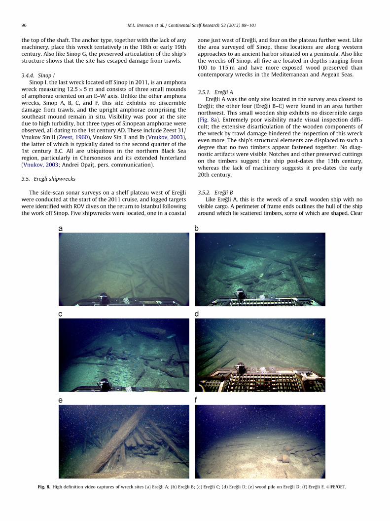
Fig. 8. High definition video captures of wreck sites (a) Eregli A; (b) Eregli B;
zone just west of Eregli, and four on the plateau further west. Likethe area surveyed off Sinop, these locations are along westernapproaches to an ancient harbor situated on a peninsula. Also likethe wrecks off Sinop, all five are located in depths ranging from100 to 115 m and have more exposed wood preserved thancontemporary wrecks in the Mediterranean and Aegean Seas.
3.5.1. Eregli A
Eregli A was the only site located in the survey area closest toEregli; the other four (Eregli B–E) were found in an area furthernorthwest. This small wooden ship exhibits no discernible cargo(Fig. 8a). Extremely poor visibility made visual inspection diffi-cult; the extensive disarticulation of the wooden components ofthe wreck by trawl damage hindered the inspection of this wreckeven more. The ship’s structural elements are displaced to such adegree that no two timbers appear fastened together. No diag-nostic artifacts were visible. Notches and other preserved cuttingson the timbers suggest the ship post-dates the 13th century,whereas the lack of machinery suggests it pre-dates the early20th century.
3.5.2. Eregli B
Like Eregli A, this is the wreck of a small wooden ship with novisible cargo. A perimeter of frame ends outlines the hull of the shiparound which lie scattered timbers, some of which are shaped. Clear
(c) Eregli C; (d) Eregli D; (e) wood pile on Eregli D; (f) Eregli E. &IFE/OET.
M.L. Brennan et al. / Continental Shelf Research 53 (2013) 89–101 97
damage from bottom trawls has ripped apart the site, with two deepscars running directly through the center of the wreck mound(Fig. 8b). Dating of this site remains inconclusive.
3.5.3. Eregli C
Eregli C is the wreck of a small Byzantine ship that has alsobeen subjected to heavy trawl damage. The majority of thetimbers lie in a jumble of disarticulated fragments atop the wreckmound, although individual timbers lie scattered about theperimeter for several dozen meters, with a few located over200 m from the main mound. Four visible LRA 1 amphorae werediscerned in the middle of the site; the shape of their bodies pointto a 6th-century date (Andrei Opait, pers. communication; seeOpait, 2010a). While most of the timbers of the ship have beendisplaced from their in situ positions, a small central area of thesite appears better preserved and includes a series of fourregularly-spaced frames set 15–20 cm apart (center to center).What appears to be a plank edge rises out of the mud on the outerface of these frames; it shows no evidence of edge joinery alongits 1.5–2.0 m of exposed length. No further evidence of the ship’soriginal form was discernible.
3.5.4. Eregli D
The remains of a large wooden ship, Eregli D, were found near thesteep slope off the edge of the shelf. The location away from bottomtrawl activity has helped to preserve this site in a notably bettercondition (Fig. 8d). Several lines of evidence suggest that the ship splitinto two pieces before arriving on the seabed. The forward half of theship lies in the SE quadrant, its axis oriented ESE. In this area severalhundred preserved wooden timbers lie in situ, including frames,futtocks and planks preserved at least to the turn of the bilge, ceilingplanks, notched deck beams, possible stanchions, and the erodedremains of either the forward part of the keel or the aft part of thestempost. Concretions from metal fasteners are apparent throughoutthe site. The shank and arm of an anchor, and possibly a length ofchain, are just visible less than a meter distant from the eastern-mostbow timber. The stern of the ship, which is less preserved, lies in theNE quadrant, its axis pointing roughly NE; the stern appears to havehad a curving transom. At the point of the break between these twosections – apparently the midships area – lies a large pile of sedimentand timbers that appear to have been violently displaced, probably asa result of the sinking event and initial deposition on the seabed. Theremains of at least two masts were documented in this area, both ofwhich lean at angles 4451; one exhibits evidence of upper worksthat have collapsed around its base. Here also was found remnants ofa cargo of lumber stacked neatly in what must have been the ship’shold (Fig. 8e). A single anchor fluke rises from the seabed near thebase of the larger mast. The vessel appears originally to havemeasured approximately 50–55 m in length and 10–12 m in width.The absence of additional visible cargo or other diagnostic artifactshave hindered the dating of this ship. Based on the degree ofpreservation, the size of the ship and its large scantlings, a provisionaldate between the 16th and 19th century is plausible.
3.5.5. Eregli E
Eregli E, the only ancient wreck found in this survey area, is arelatively large wreck of a merchant ship dating to the Late Classical/Early Hellenistic period. The wreck site measures 23�8 m and iscomposed of amphorae and displaced wood fragments. The ship wascarrying at least nine different types of amphorae, almost none ofwhich remain wholly intact. Three types originate from Ponticproduction centers, including Chersonesos (type I]) from the late4th century B.C. (Monachov, 1989; Kac et al., 2002), Sinop from themid-4th to early 3rd century B.C. (Monachov, 1992), and an unknownSouth Pontic center, perhaps from the late 4th or early 3rd century
B.C. (Monachov, 1999). Four other types were produced in Aegeancenters: Thasos in the late 4th and early 3rd century B.C., Knidos inthe late 4th or early 3rd century B.C. (Monachov, 1999; Empereur andTuma, 1988), and Rhodes in the late 4th century B.C. The date rangesof these identifiable types help pinpoint the wreck to the last quarterof the 4th century B.C. (Andrei Opait, pers. communication). Thetimbers of the ship have also suffered violent displacement as a resultof trawling damage, the scars of which are evident on the surround-ing seabed. Some timbers appear to lie in situ while others liescattered around the site. From these timbers it is evident that theship employed at least two types of joinery, pegged mortise andtenon, and sewn construction. The latter technique, evident from thetelltale tetrahedral notches cut into some of the plank edges, is to ourknowledge the first evidence of this distinctly Greek style of ship-construction in the Black Sea.
4. Discussion
4.1. Shipwreck sites
Deep-water surveys typically consist of concentrated samplingover a large area. This is one of the first large-area, comprehensiveacoustic and video surveys of the seabed in this region of the BlackSea across the oxic/anoxic interface. As such, the combined data setscollected in 2000 and 2011 have produced good documentation ofthe number of shipwrecks in the area. While it is unlikely that theseare the only ships that sank in the region, these surveys provide aninformative view of the wrecks that have been preserved and oftheir varying states of preservation. As such, our research permits anexamination of the processes and events that have both preservedand impacted the sites over time. The investigation of these wrecksalso allows for a more comprehensive picture of ancient andmedieval seafaring along what is believed to be a heavily-trafficked maritime corridor near the south coast between theBosporus and ancient and medieval Trabzon (Davis, 2009). Thediscovery of a high density of wrecks west of both Heraclea Ponticaand Sinope lends support to this hypothesis.
The history and economy of Sinop in the Early Byzantineperiod is becoming better known owing to the discovery of thefive Byzantine shipwrecks in 2000 and 2011. Sinop A, B, and C,discovered in 2000, and reinvestigated in 2003 and 2011, allcontained cargoes of carrot-shaped amphorae manufactured in oraround Sinop in the 5th century A.D. (Ballard et al., 2001; Ward andBallard, 2004; Ward and Horlings, 2008). Wrecks A, B, and C lie verynear each other: Sinop A and C lie just 150 m apart and about 1.7 kmaway from Sinop B. Sinop D, also located in 2000, and the other fourwrecks found in 2011, suggest this area was the crossroads of twowell-traveled maritime corridors, one that skirted the coast of theentire southern shore, the other an open-sea corridor that leadsnorthward from the peninsula to the Crimea (Maximova, 1959;Gajdukevich, 1969; Davis, 2009). The carrot-shaped amphorae ofSinop A, B, and C exhibit a high degree of uniformity in theirdimensions and shapes with only slight variations that are character-istic of industrial production (Andrei Opait, pers. communication).Therefore, given their proximity, it may be that all three ships, andperhaps others similarly laden, departed Sinop under convoy forpoints west or north before sinking very close to each other as a resultof a violent squall. It is well documented in antiquity and the MiddleAges that merchant vessels sailed in convoys, and that harbors oftenemptied on the same day in spring when the sailing season began,(e.g., Goitein, 1999; Casson, 1995; Davis, 2009). Such was hypothe-sized for the two Phoenician wrecks found in deep water offAshkelon, Israel, both carrying nearly identical amphorae, with onlyminor variations. They likely sank at the same time in a storm orsudden squall (Ballard et al., 2002).
M.L. Brennan et al. / Continental Shelf Research 53 (2013) 89–10198
Sinop F, dated to the late 5th or early 6th century A.D., was foundjust 500 m from Sinop B. This wreck is slightly later in date thanSinop A, B and C; more importantly, this vessel was clearly headedtoward Sinop, unlike the others. Its cargo of goods stored in contain-ers that hail from the Aegean, Gaza/Ashkelon, and North Africasuggests that Sinop was well connected to the trading networks ofthe Early Byzantine Empire. It and the other Sinop wrecks add depthto our view of Sinop as a vibrant trading center long after the city’sheyday in the Greek and Roman periods (Robinson, 1906; Doonan,2004). Sinop I, the earliest of the wrecks so far located off Sinop,dating to the 1st century A.D., sank with its cargo of Sinopean wineshortly after its departure. Given its location, the ship may have beenheaded westward, possibly to Heraclea, the Bosporus, or pointsbeyond. On the other hand, these specific amphora types turn up inlarge numbers in the northern Black Sea, particularly in the Crimea(e.g., Zeest, 1960). The ship, then, may have been about to make theopen-sea passage before sinking.
Unlike most of the shipwrecks found off Sinop, the five shipwrecksfound off Eregli show no obvious connection to this important tradingcenter. Nevertheless, they provide insights into the kinds of ships thatwere active along this stretch of coast between antiquity and the pre-modern period. Eregli E is among the earliest shipwrecks found todate in the Black Sea. The variety of late 4th-century B.C. amphoratypes found on the wreck suggests that the ship called at severalAegean ports, including Rhodes, Knidos and Thasos, before transitingthe Bosporus. Based on the north Pontic amphorae discovered on thewreck, the ship then sailed north, probably along the west Ponticcoast. At some point, perhaps at the mouth of the Danube, the shipmade the open-water crossing to western Crimea, a well-attestedroute in this period (Periplus of Pseudo-Scylax, 68; Gajdukevich, 1969;Davis, 2009). After picking up a small cargo of wine at Chersonesos,the ship headed south across the open sea to Sinop, where it pickedup more cargo, then headed west before sinking off of HeracleaPontica, the next likely stop on its circuitous voyage. The other fourwrecks off Eregli have few visible diagnostic artifacts, hinderingfurther conclusions about their origins or destinations.
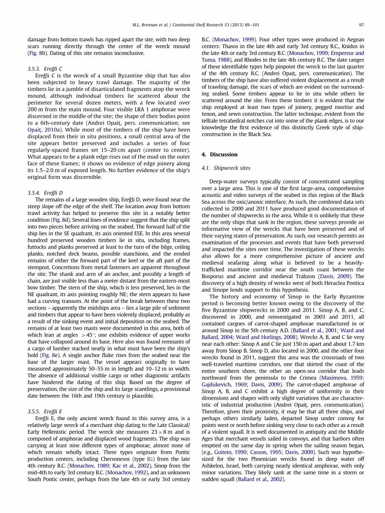
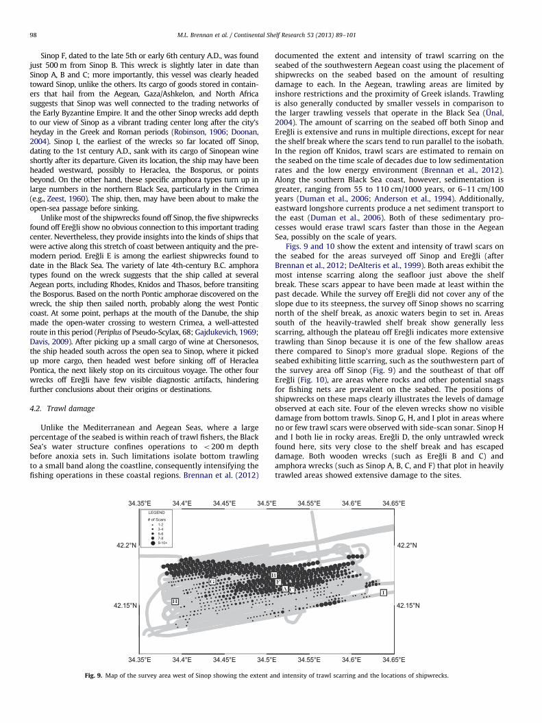
4.2. Trawl damage
Unlike the Mediterranean and Aegean Seas, where a largepercentage of the seabed is within reach of trawl fishers, the BlackSea’s water structure confines operations to o200 m depthbefore anoxia sets in. Such limitations isolate bottom trawlingto a small band along the coastline, consequently intensifying thefishing operations in these coastal regions. Brennan et al. (2012)
34.35°E 34.4°E 34.45°E
34.45°E
34.5°E
34.5°E
42.15°N
42.2°N
LEGEND
# of Scars1-23-45-67-89-10+
34.35°E
34.35°E34.35°E
34.4°E
34.4°E34.4°E
34.45°E
34.45°E
34.5°E
34.5°E
42.15°N
42.2°N
Fig. 9. Map of the survey area west of Sinop showing the extent a
documented the extent and intensity of trawl scarring on theseabed of the southwestern Aegean coast using the placement ofshipwrecks on the seabed based on the amount of resultingdamage to each. In the Aegean, trawling areas are limited byinshore restrictions and the proximity of Greek islands. Trawlingis also generally conducted by smaller vessels in comparison tothe larger trawling vessels that operate in the Black Sea (Unal,2004). The amount of scarring on the seabed off both Sinop andEregli is extensive and runs in multiple directions, except for nearthe shelf break where the scars tend to run parallel to the isobath.In the region off Knidos, trawl scars are estimated to remain onthe seabed on the time scale of decades due to low sedimentationrates and the low energy environment (Brennan et al., 2012).Along the southern Black Sea coast, however, sedimentation isgreater, ranging from 55 to 110 cm/1000 years, or 6–11 cm/100years (Duman et al., 2006; Anderson et al., 1994). Additionally,eastward longshore currents produce a net sediment transport tothe east (Duman et al., 2006). Both of these sedimentary pro-cesses would erase trawl scars faster than those in the AegeanSea, possibly on the scale of years.
Figs. 9 and 10 show the extent and intensity of trawl scars onthe seabed for the areas surveyed off Sinop and Eregli (afterBrennan et al., 2012; DeAlteris et al., 1999). Both areas exhibit themost intense scarring along the seafloor just above the shelfbreak. These scars appear to have been made at least within thepast decade. While the survey off Eregli did not cover any of theslope due to its steepness, the survey off Sinop shows no scarringnorth of the shelf break, as anoxic waters begin to set in. Areassouth of the heavily-trawled shelf break show generally lessscarring, although the plateau off Eregli indicates more extensivetrawling than Sinop because it is one of the few shallow areasthere compared to Sinop’s more gradual slope. Regions of theseabed exhibiting little scarring, such as the southwestern part ofthe survey area off Sinop (Fig. 9) and the southeast of that offEregli (Fig. 10), are areas where rocks and other potential snagsfor fishing nets are prevalent on the seabed. The positions ofshipwrecks on these maps clearly illustrates the levels of damageobserved at each site. Four of the eleven wrecks show no visibledamage from bottom trawls. Sinop G, H, and I plot in areas whereno or few trawl scars were observed with side-scan sonar. Sinop Hand I both lie in rocky areas. Eregli D, the only untrawled wreckfound here, sits very close to the shelf break and has escapeddamage. Both wooden wrecks (such as Eregli B and C) andamphora wrecks (such as Sinop A, B, C, and F) that plot in heavilytrawled areas showed extensive damage to the sites.
34.55°E
34.55°E
34.6°E
34.6°E
34.65°E
34.65°E
42.15°N
42.2°N
34.55°E
34.55°E
34.6°E
34.6°E
34.65°E
34.65°E
42.15°N
42.2°N
nd intensity of trawl scarring and the locations of shipwrecks.
LEGEND# of Scars
1-23-45-67-89-10+
30.2°E30.2°E
30.2°E30.2°E
30.25°E30.25°E
30.25°E30.25°E
30.3°E30.3°E
30.3°E30.3°E
30.35°E30.35°E
30.35°E30.35°E
30.4°E30.4°E
30.4°E30.4°E
30.45°E30.45°E
30.45°E30.45°E
30.5°E30.5°E
30.5°E30.5°E
41.35°N41.35°N 41.35°N41.35°N
41.4°N41.4°N 41.4°N41.4°N
41.45°N41.45°N 41.45°N41.45°N
Fig. 10. Map of the survey area west of Eregli showing the extent and intensity of trawl scarring and the locations of shipwrecks.
M.L. Brennan et al. / Continental Shelf Research 53 (2013) 89–101 99
One of the objectives of the expedition’s return to the BlackSea was to revisit the Sinop A, B, and C wreck sites and re-evaluate their condition after eleven years. Only partial photo-mosaics were produced in 2000, so new imaging surveys wereconducted of sites A and B. What was immediately apparent inthe 2011 photomosaic of Sinop A (Fig. 2) is the swept appearanceof the wreck site by trawls. Scars run across the site in multipledirections, but the dominant orientation of the marks is roughlyE–W, which is the observed direction of the scars in side-scansonar running parallel to the slope. Despite initial statements tothe contrary (Ballard et al., 2001; Ward and Horlings, 2008),a reexamination of still photo imagery from 2000 shows thatSinop A was damaged by trawl fishing at the time of its discovery,both in broken artifacts and trawl scars visible in the surroundingsediment. A comparison to data from the 2011 surveys shows thatover the course of the intervening eleven years, Sinop A hassuffered serious additional damage. An estimate of broken vs.unbroken amphorae from these images in 2000 shows about 21%broken, whereas a count based on the 2011 photomosaic shows59% broken (after Brennan et al., 2012). This reexaminationillustrates that the wrecks are continually threatened by trawling,as they lie in an area of intense fishing activity and have beensignificantly damaged over the past decade.
The new amphora wrecks found in 2011 are also indicative of thelocalized areas of heavy trawling shown in the intensity maps. Theonly one found outside of heavily trawled areas is Sinop I, on whichonly a handful of amphorae (o5%) appear to be broken, a propor-tion that can reasonably be attributed to the ship’s wrecking event(Brennan et al., 2012). Many are still upright in their originalpositions. However, photomosaics of Sinop F and Eregli E indicateeven more damage than Sinop A; 60% of the visible amphorae ofSinop F are broken, as are 68% of those from Eregli E. This damageis greater than any wreck we have documented in the Aegean Sea.The discovery of preserved wooden planks from Eregli E is probablydue to trawls overturning timbers that had been preserved under-neath the sediment. Such uprooting of preserved timbers is alsoevident at the other trawled amphora wrecks off Sinop, especially Aand F. The large timber visible in the Sinop A photomosaic (Fig. 2)appears to be part of the mast and was not visible in 2000.Disarticulated timbers may represent pieces of wood or brush thatare part of modern debris commonly trapped by shipwrecks (e.g.,McNinch et al., 2006). This is particularly true in the case of thebetter-preserved wooden wrecks, which have a higher relief on theseabed and appeared in side-scan sonar as mounds of sediment withlinear reflections jutting out.
It is becoming increasingly evident that trawling has a pro-found impact on the site formation processes leading to thecurrent state of preservation of pre-modern wrecks. This isespecially apparent at the sites where the wooden components
are still preserved on the seabed. Due to the characteristics of thewater column of the Black Sea Eregli A, B, and C would have likelyremained as intact as Sinop G, H, and Eregli D. Instead, the formerare heavily impacted sites that now consist of mounds of trappedsediment with a litter of timbers scattered about the surroundingseabed. These wrecks, with little to no visible cargo, would havelikely deteriorated completely had they sank in the oxic waters ofthe Mediterranean, but were preserved and able to be found inthe Black Sea due to the suboxic conditions. Trawling over thepast century has disturbed and destroyed sites that had been inequilibrium with the surrounding environment for centuries. Thisinteraction of ocean dynamics and anthropogenic activities hasboth preserved these wrecks and destroyed their integrity, leavingwhat we see today as nearly unrecognizable wooden remnantsof ships.
4.3. Dynamics of the oxic/anoxic interface
Despite the location of all eleven of these wrecks within a15 m depth range of each other, there are differing degrees ofpreservation evident along the sites. The main factor at workbetween the better articulated wooden wrecks (Sinop G, H; EregliD) and the degraded wooden wrecks (Eregli A, B, C) is bottomtrawling. Even with extensive damage to some of the sites,timbers are well preserved and show little to no evidence ofdeterioration. At the same time, however, while the five amphorawrecks contain some preserved timbers, the ships’ structureshave mostly deteriorated, like those seen in deep waters in theAegean and Mediterranean Seas where no wood remains visibleon the surface of the sites (e.g., Brennan et al., 2012). Thedegradation of the wooden components of ships is caused bywood-boring organisms, such as Teredinidae and pholadidae,such as Xylophaginae, depending on depth, both of which arefound in the Black Sea and Sea of Marmara areas (e.g., Culha,2010; Micu, 2007). While teredinids can survive periods of anoxia(e.g., Richards et al., 1984), the waters of the Black Sea preventtheir settling onto wooden structures and therefore their survival.This lack of teredinids causes the highly preserved condition ofwrecks such as Sinop D within the anoxic layer (Ward and Ballard,2004). Like Sinop D, the timbers of all the wooden ships found in2011appear free of any damage from teredinid boring, regardlessof trawl damage. This is not, however, the case for the largelydestroyed timbers from the amphora wrecks. For example, someof the amphorae at Sinop A remained in their original stackedorientation in 2000, but the wooden structure around them hassince disappeared (Ward and Ballard, 2004). Regardless, the artifactorientation still preserved in 2000 appears to have been substantivelydestroyed by trawling in the intervening eleven years.
M.L. Brennan et al. / Continental Shelf Research 53 (2013) 89–101100
The differences in the observed condition of the woodencomponents of these wrecks is not related to depth, as they areall within a similar depth range, nor is it merely due to age, asteredinids have been shown to colonize a wreck site within fiveyears (Bergstrand, 2010). Putting trawling aside, a shift in thedepth of the chemocline appears to be the primary cause of thedisparate preservation of these sets of wrecks. A core taken fromthe region just east of Sinop at 160 m depth indicated a shoalingof the oxic/anoxic interface with a shift from bioturbated sedi-ments to undisturbed laminae above, showing that the oxic layerwas once at that depth, about 200 years ago (Anderson et al.,1994). Shoaling events and fluctuations in the chemocline depthhave been documented as responses to natural forces, but notwith such a sustained condition as here (e.g., Arnold et al., 2012;Lyons et al., 1993). One possible cause of this shoaling event is theopening of canals between tributaries of rivers draining into theBlack and Baltic Seas in the early 1800s. These canals facilitatedthe transport of invasive species, such as zebra mussels, betweenthe bodies of water (e.g., Buynevich et al., 2011; Olenin andLeppakoski, 1999). The timing of the canal construction andchanges to freshwater discharge into the Black Sea likely had animpact on its physico–chemical structure. Regardless, theamphora wrecks may have been fully within the oxic watersfrom the time of their sinking until this shoaling event occurred.The well-articulated wooden wrecks from more recent timeslikely spent little to no time in fully oxygenated waters, thussupplying a provisional terminus post quem for their sinking in thelate 18th to early 19th century. Additionally, all of these wreckslie just above the 120 m depth at which we observed thebeginning of the suboxic zone. We hypothesize that internalwaves moving across the oxic/anoxic interface wash anoxic waterup across the shelf frequently enough to prevent the settling andsurvival of planktonic wood-boring mollusk larvae. The shoalingevent, therefore, raised the chemocline enough to bring thesewrecks within reach of the waves’ effects. The exposure ofpreserved timbers from the amphora wrecks as a result oftrawling, and their subsequent survival, also illustrate the effectof the internal waves on the benthic communities.
The preliminary results of the biological analyses reportedhere from cores of sediments underlying the oxic, suboxic, andanoxic water layers support the existence of varying dissolvedoxygen levels in the suboxic zone. The CFU counts of bacteria aswell as the counts of meiofauna show similar community popula-tions in the oxic and suboxic cores, and depleted communities inthe anoxic core. The anoxic layer has been stable and stagnant,but the results here show a more dynamic layer in the suboxiczone, one that may indicate phases of both anoxic and oxic watersin this region of the continental slope. Present in the suboxic coreswere facultative anaerobes that can function in either oxic oranoxic environments, as well as benthic fauna that can withstandlow oxygen conditions. While the anoxic layer is stable withrespect to the conditions for wreck preservation and the survivalof benthic communities, the internal wave effects on the seabedwere also evident in the side-scan sonar as megaripples. Suchareas of bedforms, which were observed at approximately 200 mdepth, indicate movement of sediment that would periodicallybury and scour any shipwrecks present at these depths, as is seenoff the North Carolina coast (e.g., McNinch et al., 2006). The BlackSea wrecks found in 2011 just above the suboxic zone also act assediment traps causing additional burial and accumulation ofmodern debris. The culmination of all of these processes creates adynamic and variable environment in which to study archaeolo-gical sites. While the anoxic waters preserve the woodencomponents of wrecks, other processes in this transitional areacan also bury or destroy these sites, regardless of theirpreservation state.
5. Conclusions
The wrecks located along the southern Black Sea coast ofTurkey provide evidence for a series of complex processesoccurring at the transition between oxic and anoxic waters. Thedynamics at this zone from 100 to 115 m depth show an unstableinterface that has not remained at one depth over time, and whichresponds to events in the form of internal waves, the effects ofwhich are manifested in varying states of preservation of pre-modern shipwreck sites. Added to this are the recent effects ofbottom trawling, further complicating the formation processesthat created the sites we see today and damaging them todiffering degrees based on their location in the bathymetriclandscape. Due to the extent of this damage, some of the moreheavily impacted wooden wrecks can only be assessed on arudimentary level with little to no diagnostic evidence of theirorigin or date. On the other hand, the ships that lacked a ceramiccargo would have little chance of surviving in any form to this dayhad they sunk in the Mediterranean or Aegean Seas. Takentogether, investigations of these wreck sites provides evidencenot only of historic seafaring, but also of the recent history of theBlack Sea’s suboxic zone and the recent extent of bottom trawlactivities.
The data collected during the 2011 cruise of E/V Nautilus
introduce more questions than answers, in particular becausethe high degree of preservation of these shipwrecks was notexpected at such shallow depths. The dynamics of the suboxiczone require more investigation, ideally on longer time scales. In2007, we deployed a sensor package equipped with a CTD, O2
sensor, and ADCP at 103 m depth off Sinop Turkey, as well as oneat 325 m in the anoxic zone. The deeper package was retrievedthe following year (results reported in Brennan et al., 2011), butthe suboxic package was not recovered; in 2011, the mooring wasdiscovered tangled in fish nets, with a long line rising up from theseabed, and the sensors missing. It appears that the intensity oftrawling in the region also presents a substantial challenge forlong-term monitoring of the depths at which internal wavesthrough the suboxic zone can be recorded. It raises a questionof how such long-term data sets can be collected while avoidingtrawling. In addition, the intensity of trawling observed off Sinopand Eregli clearly presents a continuing threat to the preservationof pre-modern era shipwrecks on the seabed above the anoxiclayer, as the 2000 and 2011 documentation of Sinop A demon-strates. Areas of high density of shipwrecks, such as the tworegions surveyed in 2011, should be considered candidates formarine protected areas, which would also allow for betterenvironmental monitoring of the suboxic zone. Further surveysand documentation of the cultural sites along the southern BlackSea margin are needed to strengthen the case for site preservationand the threats posed by bottom trawling.
Acknowledgments
The authors wish to thank Robert Ballard, Katy Croff Bell, TufanTuranli, Andrei Opait, Gulsen Altug, Heather Schrum, Kroum Batch-varov, Jim Delgado, Cheryl Ward, Rachel Horlings, Art Trembanis,David Smith, Ashton Flinders, Brennan Phillips, Mike Filimon, MattSlusher, Roderick MacLeod, Gabrielle Inglis, Sarah Fuller, SandraWitten, Barbaros Simsek, Turkish Ministry of Foreign Affairs, andMinistry of Culture and Tourism and the Captain and crew of the E/V
Nautilus. Funding for this work was provided by the NOAA’s Office ofOcean Exploration (NA08OAR4600534, NA10OAR4600127), the Expe-dition Council of the National Geographic Society, and the Office ofNaval Research (N00014–07–1–0301).
M.L. Brennan et al. / Continental Shelf Research 53 (2013) 89–101 101
References
Anderson, R.F., Lyons, T.W., Cowie, G.L., 1994. Sedimentary record of a shoaling ofthe oxic/anoxic interface in the Black Sea. In: Scranton, M.I. (Ed.), Variability inAnoxic Systems. Marine Geology, 116; 1994, pp. 373–384.
Arnold, G.L., Lyons, T.W., Gordon, G.W., Anbar, A.D., 2012. Extreme change insulfide concentrations in the Black Sea during the Little Ice Age reconstructedusing molybdenum isotopes. Geology 40 (7), 595–598.
Avram, A., Hind, J., Tsetskhladze, G., 2004. The Black Sea area. In: Hansen, M.H.,Nielsen, T.H. (Eds.), An inventory of Archaic and Classical poleis. OxfordUniversity Press, Oxford, pp. 924–973.
Ballard, R.D., Hiebert, F.T., Coleman, D.F., Ward, C., Smith, J.S., Willis, K., Foley, B.,Croff, K., Major, C., Torre, F., 2001. Deepwater archaeology of the Black Sea: the2000 season at Sinop, Turkey. American Journal of Archaeology 105, 607–623.
Ballard, R.D., Stager, L.E., Master, D., Yoerger, D., Mindell, D., Whitcomb, L.L., Singh,H., Piechota, D., 2002. Iron Age shipwrecks in deep water off Ashkelon,Israel. American Journal of Archaeology 106, 151–168.
Bascom, W., 1976. Deep Water, Ancient Ships. Doubleday & Company, Inc., New York.Bergstrand, T., 2010. The Danish 7th-century Man-of-War Stora Sofia: documenta-
tion and in situ preservation. International Journal of Archaeology 39, 56–65.Brennan, M.L., Ballard, R.D., Archaeological Oceanography. Encyclopedia of Natural
Resources, in press.Brennan, M.L., Ballard, R.D., Bell, K.L.C., Piechota, D., 2011. Archaeological oceanography
and environmental characterization of shipwrecks in the Black Sea, in: Buynevich,I., Yanko-Hombach, V., Gilbert, A., Martin, R.E. (Eds.), Geology and Geoarchaeologyof the Black Sea Region: Beyond the Flood Hypothesis. Geological Society ofAmerica Special Paper 473, pp. 179–188, http://dx.doi.org/10.1130/2011.2473(11).
Brennan, M.L., Ballard, R.D., Roman, C., Bell, K.L.C., Buxton, B., Coleman, D.F., Inglis,G., Koyagasioglu, O., Turanli, T., 2012. Evaluation of the modern submarinelandscape off southwestern Turkey through the documentation of ancientshipwreck sites. Continental Shelf Research 43, 55–70.
Burstein, S.M., 1976. Outpost of Hellenism: The Emergence of Heraclea on theBlack Sea. University of California Press, Berkley.
Buynevich, I.V., Damusyte, A., Bitinas, A., Olenin, S., Mazeika, J., Petrosius, R., 2011.Pontic-Baltic pathways for invasive aquatic species: geoarchaeological impli-cations, in: Buynevich, I., Yanko-Hombach, V., Gilbert, A., Martin, R.E. (Eds.),Geology and Geoarchaeology of the Black Sea Region: Beyond the FloodHypothesis. Geological Society of America Special Paper 473, pp. 189–196,http://dx.doi.org/%2010.1130/2011.2473(12).
Casson, L., 1995. Ships and Seamanship in the Ancient World, New ed.. JohnsHopkins University Press, Baltimore and London.
Coleman, D.F., Ballard, R.D., 2004. Archaeological oceanography of the BlackSea. In: Akal, T., Ballard, R.D., Bass, G.F. (Eds.), The Application of RecentAdvances in Underwater Detection and Survey Techniques to UnderwaterArchaeology. Uluburun Publishing, Istanbul, pp. 49–58.
Culha, M., 2010. The presence of Teredo navalis Linnaeus, 1758 (Mollusca, Bivalvia,Teredinidae) in the southern Black Sea, Turkey. Journal of Animal andVeterinary Advances 9, 1515–1518.
Davis, D.L. 2009. Commercial Navigation in the Greek and Roman World. Ph.D.Dissertation. University of Texas at Austin.
DeAlteris, J., Skrobe, L., Lipsky, C., 1999. The significance of seabed disturbance bymobile fishing gear relative to natural processes: a case study in NarragansettBay, Rhode Island. American Fisheries Society Symposium 22, 224–237.
Doonan, O.P., 2004. Sinop Landscapes: Exploring Connections in a Black SeaHinterland. University of Pennsylvania Museum of Archaeology and Anthro-pology, Philadelphia.
Duman, M., Duman, S., Lyons, T.W., Avci, M., Izdar, E., Demirkurt, E., 2006.Geochemistry and sedimentology of shelf and upper slope sediments of thesouth-central Black Sea. Marine Geology 227, 51–65.
Empereur, J.-Y., Tuma, N., 1988. Zenon de Caunos et l’epave de Serc-e Limani.Bulletin de correspondance hellenique 112, 341–357.
Filonov, A.E., 2000. Thermic structure and intense internal waves on the narrowcontinental shelf of the Black Sea. Journal of Marine Systems 24, 27–40.
Gajdukevich, V.F., 1969. On how ancient greek ships sailed across the PontusEuxine. Kratikie Soobshcheniia Instituta Arkheologii 116, 11–19, in Russian.
Glazer, B.T., Luther III, G.W., Konovalov, S.K., Friederich, G.E., Nuzzio, D.B.,Trouwborst, R.E., Tebo, B.M., Clement, B., Murray, K., Romanov, A.S., 2006a.Documenting the suboxic zone of the Black Sea via high-resolution real-timeredox profiling. Deep-Sea Research II 53, 1740–1755.
Glazer, B.T., Luther III, G.W., Konovalov, S.K., Friederich, G.E., Trouwborst, R.E.,Romanov, A.S., 2006b. Spatial and temporal variability of the Black Sea suboxiczone. Deep-Sea Research II 53, 1756–1768.
Goitein, S.D. 1999. Reprint. A Mediterranean Society: The Jewish Communities ofthe World as Portrayed in the Documents of the Cairo Geniza. Vol. 1, EconomicFoundations. Berkeley, University of California Press. Original edition, 1967.
Hind, J.G.F., 1988. The colonisation of Sinope and the S.E. Black Sea area, in:Mestnye etnopoliticheskie obedineniya Prichernomor’ya VII-IV vekakh do n.e.,Materialy IV Vsesoyuznogo Sympozyuma po drevnej istorii. Tblisi, pp. 207–23.
Isager, S., Hansen, M.H., 1975. Aspects of Athenian society in the fourth centuryB.C. Odense University Press, Odense.
Johnson-Roberson, M., Pizarro, O., Williams, S.B., Mahon, I.J., 2010. Generation andvisualization of large-scale three-dimensional reconstructions from under-water robotic surveys. Journal of Field Robotics 27 (1), 21–51.
Kac, V.I., Monachov, S.Y., Stolba, V.F., Shcheglov, A.N., 2002. Tiles and ceramiccontainers. In: Hannestad, L., Stolba, V.F., Shcheglov, A.N. (Eds.), The MonumentalBuilding U6, vol.1. Aarhus University Press, Aarhus, pp. 101–126, Panskoye I.
Kuscu, I., Parke, J.R., White, R.S., McKenzie, D., Anderson, G.A., Minshull, T.A., Gorur,N., Sengor, A.M.C., 2004. Active slumping offshore Amasra (southwest BlackSea) and its relation with regional tectonics. Bulletin of the Mineral Researchand Exploration 128, 27–47.
Luth, U., Luth, C., 1998. Benthic meiofauna and macrofauna of a methane seep areasouth-west of the Crimean Peninsula, Black Sea, in: Luth, U., Luth, C., Thiel, H.(Eds.), MEGA-SEEPS-Methane Gas Seeps Exploration in the Black Sea. Berichteaus dem Zentrum fuer Meeres-und Klimatoforsch, Hamburg 14, pp. 59–77.
Lyons, T.W., Berner, R.A., Anderson, R.F., 1993. Evidence for large pre-industrialperturbations of the Black Sea chemocline. Nature 365, 538–540.
Maximova, M.I., 1959. Der Kurze Seeweg uber das Schwarze Meer im Altertum.Klio. Beitrage zur alten Geschichte. 37, 101–118.
McNinch, J.E., Wells, J.T., Trembanis, A.C., 2006. Predicting the fate of artefacts inenergetic, shallow marine environments: an approach to site management.International Journal of Nautical Archaeology 35, 290–309.
Micu, D., 2007. Recent records of Pholas dactylus (Bivalvia: Myoida: Pholadidae)from the Romanian Black Sea, with considerations on its habitat and proposedIUCN regional status. Acta Zoologica Bulgarica 59, 267–273.
Monachov, S.Y., 1989. Amfory Chersonesa Tavricheskogo IV-II vv. Do n.e. Opytsistemnogo analiza. Saratov (in Russian).
Monachov, S.Y., 1992. Dinamika form i standartov sinopskih amfor, in: Grecheskieamfor’. Saratov. Saratov, pp. 163–204 (in Russian).
Monachov, S.Y., 1999. Grecheskis amfory v Prichernomor’e: kompleksy kerami-cheskoiy tary VII-II vv. do n.e. Saratov (in Russian).
Murray, J.W., Jannasch, H.W., Honjo, S., Anderson, R.F., Reeburgh, W.S., Top, Z.,Friedrich, G.E., Codispoti, L.A., Izdar, E., 1989. Unexpected changes in the oxic/anoxic interface in the Black Sea. Nature 338, 411–413.
Murray, J.W., Stewart, K., Kassakian, S., Krynytzky, M., DiJulio, D., 2007. Oxic, suboxic,and anoxic conditions in the Black Sea. In: Yanko-Hombach, V., Gilbert, A.S., Panin,N., Dolukhanov, P.M. (Eds.), The Black Sea Flood Question: Changes in Coastline,Climate and Human Settlement. Springer, Dordrecht, pp. 1–22.
Newman, J.B., Gregory, T.S., Howland, J., 2008. The development of towed opticaland acoustical vehicle systems and remotely operated vehicles in support ofarchaeological oceanography. In: Ballard, R.D. (Ed.), Archaeological Oceanography.Princeton University Press, Princeton, pp. 15–29.
Oguz, T., La Violette, P.E., Unluata, U., 1992. The upper layer circulation of the BlackSea: its variability as inferred from hydrographic and satellite observations.Journal of Geophysical Research 97, 12569–12584.
Olenin, S., Leppakoski, E., 1999. Non-native animals in the Baltic Sea: alteration ofbenthic habitats in coastal inlets and lagoons. Hydrobiologia 393, 233–243.
Opait, A., 1997–1998. New pottery from the circular harbour at Carthage. CEDACCarthage 18, 21–35.
Opait, A., 2010a. On the origin of Carthage LR Amphora 1, in: Menchelli, S., Santoro, S.,Pasquinuci, M., Guiducci, G. (Eds.), LRCW3. Late Roman Coarse Wares, CookingWares and Amphorae in the Mediterranean. BAR-IS 2185, pp. 1015–1022.
Opait, A., 2010b. Sinopean, Heraklean and Chersonesan ‘‘Carrot’’ amphorae.Ancient Civilizations from Scythia to Siberia 16 (371–401), 552–556.
Richards, B.R., Hillman, R.E., Maciolek, N.J., 1984. Shipworms. In: Kennish, M.J.,Lutz, R.A. (Eds.), Lecture Notes on Coastal and Estuarine Studies—Ecology ofBarnegat Bay, New Jersey. Springer-Verlag, New York, pp. 201–225.
Robinson, D., 1906. Ancient Sinope. American Journal of Philology 27 (125–53),245–279.
Roman, C., Singh, H., 2007. A self-consistent bathymetric mapping algorithm.Journal of Field Robotics 24, 23–50.
Ryan, W.B.F., Pitman III, W.C., Major, C.O., Shimkus, K., Moskalenko, V., Jones, G.A.,Dimitrov, P., Gorur, N., Sakınc- , M., Yuce, H., 1997. An abrupt drowning of theBlack Sea shelf. Marine Geology 138, 119–126.
Saprykin, S.J., 1997. Heracleia Pontica and Tauric Chersonesus before RomanDomination: VI-I Centuries B.C. A.M. Hakkert, Amsterdam.
Sergeeva, N.G., 2003. Meiobenthos in the region with the methane gas seeps,in: Eremeev, V.N., Gaevskaya A.V. (Eds.), Present Time Conditions ofBiological Diversity in the Nearshore Zone of Crimea Peninsula (the BlackSea sector). Ecosi-Gidrophizika, Sevastopol, pp. 258–267 (in Russian).
Sergeeva, N.G., Gulin, M.B., 2007. Meiobenthos from an active methane seepagearea in the NW Black Sea. Marine Ecology 28, 152–159.
Trembanis, A., Skarke, A., Nebel, S., Coleman, D.F., Ballard, R.D., Fuller, S.A.,Buynevich, I.V., Voronov, S., 2011. Bedforms, hydrodynamics, and scourprocess observations from the continental shelf of the northern Black Sea,in: Buynevich, I., Yanko-Hombach, V., Gilbert, A., Martin, R.E. (Eds.), Geologyand Geoarchaeology of the Black Sea Region: Beyond the Flood Hypothesis.Geological Society of America Special Paper 473, pp. 165–178, http://dx.doi.org/%2010.1130/2011.2473(10).
Trouwborst, R.E., Clement, B.G., Tebo, B.M., Glazer, B.T., Luther, G.W., 2006. SolubleMn in suboxic zones. Science 313, 1955–1957.
Unal, V., 2004. Viability of trawl fishing fleet Foca (the Aegean Sea), Turkey andsome advices to central management authority. Turkish Journal of Fisheriesand Aquatic Sciences 4, 93–97.
Vnukov, S.Y., 2003. Prichernomorskie amfory I v. do n.e.–II v. n.e. (morphologiya),vol. I. Institut arkheologii RAN, Moscow (in Russian).
Ward, C., Ballard, R., 2004. Black Sea shipwreck survey 2000. International Journalof Nautical Archaeology 33, 2–13.
Ward, C., Horlings, R., 2008. The remote exploration and archaeological survey offour Byzantine ships in the Black Sea. In: Ballard, R.D. (Ed.), ArchaeologicalOceanography. Princeton University Press, Princeton, pp. 148–173.
Zeest, I.B., 1960. Keramicheskaya tara Bospora. Izd-vo Akademii nauk SSSR,Moscow (in Russian).