Embed Size (px)
Citation preview
1. AThe water on the surface of the oceans is constantly flowing in one direction from one place to another. These flowing movements of water in oceans are called ocean currents. Ocean current, stream made up of horizontal and vertical components of the circulation system of ocean waters that is produced by gravity, wind friction, and water density variation in different parts of the ocean.
The current's direction and speed depend on the shoreline and the ocean floor. They can flow for thousands of miles and are found in all the major oceans of the world.
currents depend on water pressure, temperature, and salt content.
Based on temperature. Ocean currents can broadly be divided into two classes—the warm and the cold currents.
Warm ocean currents originate near the equator and move towards the poles or higher latitudes while cold currents originate near the poles or higher latitudes and move towards the tropics or lower latitude.
Currents in the western part of every continent is cold. Currents coming from the polar region are generally cold. Currents near to equator are generally warm.
1. The Warm Currents: These are those currents which flow from the low latitudes in Tropical Zones towards the high latitudes in the Temperate and Subpolar Zones. They bring warm water into cold water areas.
2.The Cold Currents: These currents have a lower surface temperature and bring cold water into warm water areas. These currents flow in the high latitudes from the Polar regions towards the low latitudes in the warm Equator region.
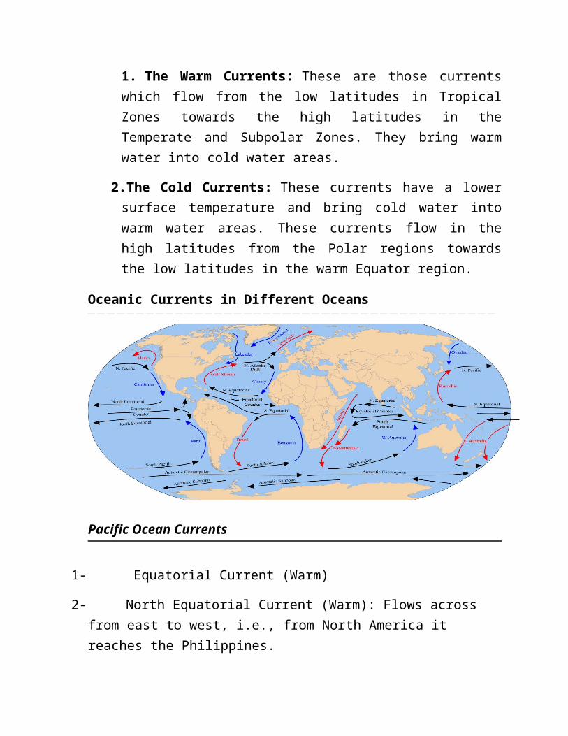
Oceanic Currents in Different Oceans
Pacific Ocean Currents
1- Equatorial Current (Warm)
2- North Equatorial Current (Warm): Flows across from east to west, i.e., from North America it reaches the Philippines.
3- South Equatorial Current (Warm): Peru Current eventually joins with the South Equatorial Current and completes the circuit.
4- Peruvian Current (Cold): Cold current near the west coast of S. America.
5- Kuroshio or Japan Current and W Winds drift (warm) Current (warm): N. Eq. current along the Philippines, Taiwan & Japan coast form this current. From the S.E. Japan the current, under the influence of prevailing westerlies, flows right across the ocean.
6- California Current (Cold): It moves southward along the coast of California
7- Oyashio or Kuril Current (Cold): Flows along the east coast of Kamchatka peninsula.
8- South Pacific Current: From west to east and crosses the Pacific Ocean along with the West Wind Drift.
9- East Australian Current (Warm): Flows from east to west in S. Pacific Ocean.
Indian Ocean Current
The currents in the N. Indian Ocean differ entirely from the general pattern of circulation. They change their direction from season to season in response to the seasonal rhythm of the monsoons.
1- Equatorial Centre Current (Warm)
2- South Equatorial Current (Warm)
3- Mozambique and Agulhas Current (Warm)
4- Monsoon Current (Warm)
5- South Indian Current (Cold)
6- West Australian Current (cold)
Atlantic Ocean Currents
1- Benguela Current (Cold): Cold current from S. to N near the ‘Cape of Good Hope’
2- South Atlantic Current (Cold)
3- Brazil Current (Warm): Flows along the S. American coast from North to South
4- Labrador Current (Cold): Flows along the eastern coast of Canada, meets the warm Gulf Stream near the north-east corner of U.S.A.
5- North Equatorial Current (Warm)
6- South Equatorial Current (Warm)
7- Gulf Stream (Warm): Beyond the Cape Hatteras up to the Grand Banks of New Found Land, Florida current is known as Gulf Stream. From the Grand Banks, the Gulf Stream moves eastward across the Atlantic as the Atlantic Drift.
8- Equatorial Counter Current or Guinea Current (Warm): Flows off the W. African coast
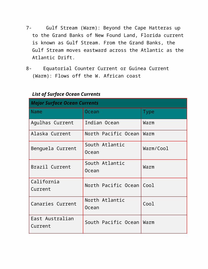
List of Surface Ocean Currents
Major Surface Ocean Currents
Name Ocean Type
Agulhas Current Indian Ocean Warm
Alaska Current North Pacific Ocean Warm
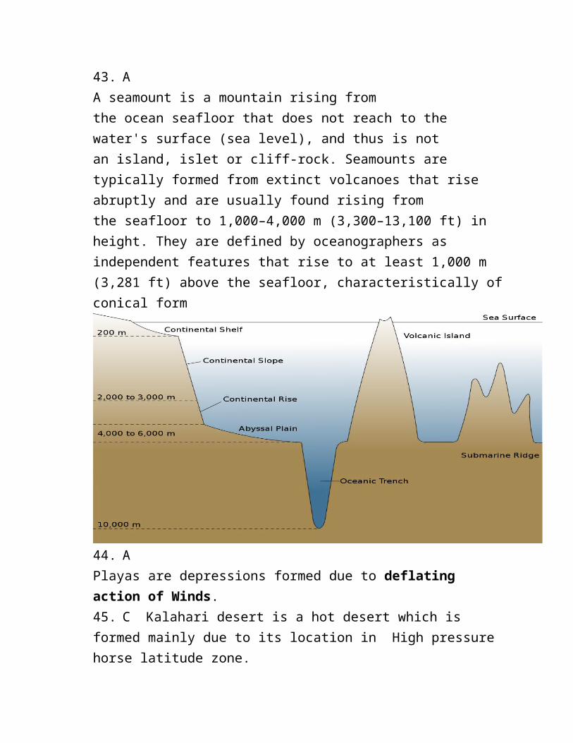
Benguela Current South Atlantic Ocean Warm/Cool
Brazil Current South Atlantic Ocean Warm
California Current North Pacific Ocean Cool
Canaries Current North Atlantic Ocean Cool
East Australian Current South Pacific Ocean Warm
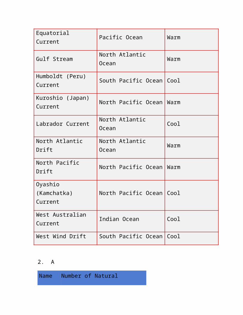
Equatorial Current Pacific Ocean Warm
Gulf Stream North Atlantic Ocean Warm
Humboldt (Peru) Current South Pacific Ocean Cool
Kuroshio (Japan) Current North Pacific Ocean Warm
Labrador Current North Atlantic Ocean Cool
North Atlantic Drift North Atlantic Ocean Warm
North Pacific Drift North Pacific Ocean Warm
Oyashio (Kamchatka) Current
North Pacific Ocean Cool
West Australian Current Indian Ocean Cool
West Wind Drift South Pacific Ocean Cool
2. A
Name Number of Natural Satellites
1 Jupiter 69
2 Saturn 61
3 Uranus 27
4 Neptune 14
5 Pluto 3
6 Mars 2
7 Earth 1
8 Venus 0
9 Mercury 0
3. C
During the year, the seasons change depending on the amount of sunlight reaching the Earth as it revolves around the Sun.
Earth has seasons because our planet's axis of rotation is tilted 23.5 degrees from the plane of its orbit around the sun i.e it makes an angle of 66.5 degrees to the plane of its orbit.
4.D
5. A
6. C
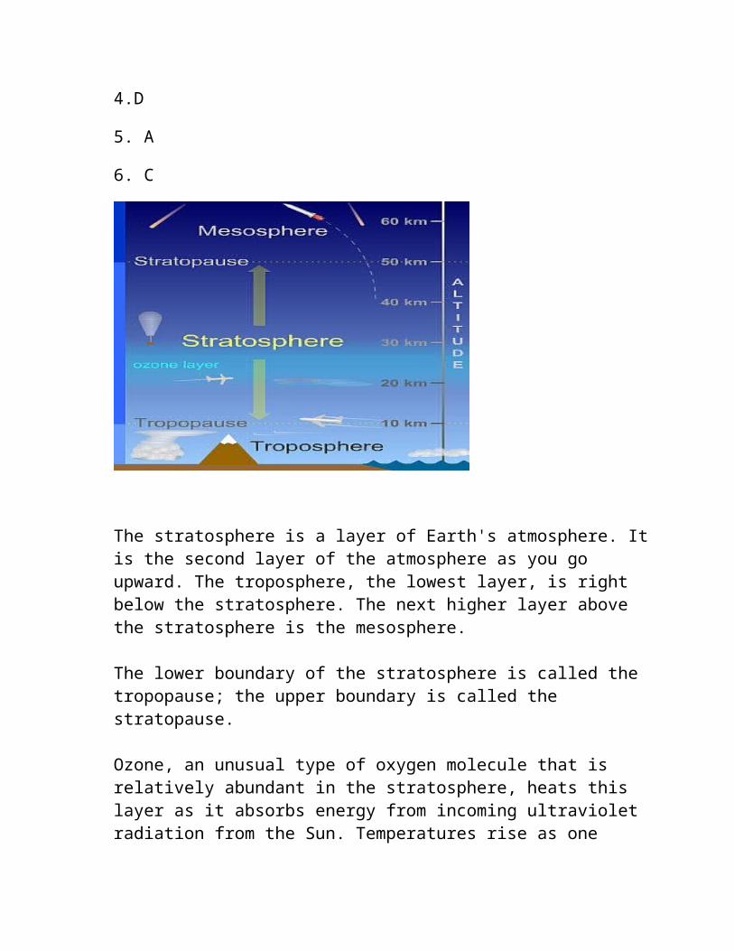
The stratosphere is a layer of Earth's atmosphere. It is the second layer of the atmosphere as you go upward. The troposphere, the lowest layer, is right below the stratosphere. The next higher layer above the stratosphere is the mesosphere.

The lower boundary of the stratosphere is called the tropopause; the upper boundary is called the stratopause.
Ozone, an unusual type of oxygen molecule that is relatively abundant in the stratosphere, heats this layer as it absorbs energy from incoming ultraviolet radiation from the Sun. Temperatures rise as one moves upward through the stratosphere. This is exactly the opposite of the behavior in the troposphere in which we live, where temperatures drop with increasing altitude. Because of this temperature stratification, there is little convection and mixing in the stratosphere, so the layers of air there are quite stable. Commercial jet aircraft fly in the lower stratosphere to avoid the turbulence which is common in the troposphere below.The stratosphere is very dry; air there contains little water vapor. Because of this, few clouds are found in this layer; almost all clouds occur in the lower, more humid troposphere.
A rare type of electrical discharge, somewhat akin to lightning, occurs in the stratosphere. These "blue jets" appear above thunderstorms, and extend from the bottom of the stratosphere up to altitudes of 40 or 50 km (25 to 31 miles).
7. C
8. A
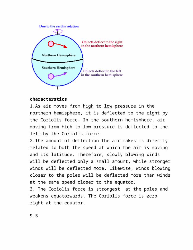
Coriolis Force: Once air has been set in motion by the pressure gradient force, it undergoes an apparent deflection from its path, as seen by an observer on the earth. This apparent deflection is called the "Coriolis force" and is a result of the earth's rotation.
characterstics1.As air moves from high to low pressure in the northern hemisphere, it is deflected to the right by the Coriolis force. In the southern hemisphere, air moving from high to low pressure is deflected to the left by the Coriolis force.2.The amount of deflection the air makes is directly related to both the speed at which the air is moving and its latitude. Therefore, slowly blowing winds will be deflected only a small amount, while stronger winds will be deflected more. Likewise, winds blowing closer to the poles will be deflected more than winds at the same speed closer to the equator.3. The Coriolis force is strongest at the poles and weakens equatorwards. The Coriolis force is zero right at the equator.
9.B
The Troposphere
The troposphere is the lowest layer of Earth's atmosphere. Almost all weather occurs within this layer. Air is warmest at the bottom of the troposphere near ground level. Higher up it gets colder. Air pressure and the density of the air are also less at high altitudes. The layer above the troposphere is called the stratosphere.
Nearly all of the water vapor and dust particles in the atmosphere are in the troposphere.
The boundary between the top of the troposphere and the stratosphere (the layer above it) is called the tropopause.
The stratosphere is a layer of Earth's atmosphere. The stratosphere is the second layer, as one moves upward from Earth's surface, of the atmosphere. The stratosphere is above the troposphere and below the mesosphere.
The top of the stratosphere occurs at 50 km (31 miles) altitude. The boundary between the stratosphere and the mesosphere above is called the stratopause.
Ozone, an unusual type of oxygen molecule that is relatively abundant in the stratosphere, heats this layer as it absorbs energy from incoming ultraviolet radiation from the Sun. Temperatures rise as one moves upward through the stratosphere. This is exactly the opposite of the behavior in the troposphere in which we live, where temperatures drop with increasing altitude. Because of this temperature stratification, there is little convection and mixing in the stratosphere, so the layers of air there are quite stable. Commercial jet aircraft fly in the lower stratosphere to avoid the turbulence which is common in the troposphere below.
The stratosphere is very dry; air there contains little water vapor. Because of this, few clouds are found in this layer; almost all clouds occur in the lower, more humid troposphere. Polar stratospheric clouds (PSCs) are the exception. PSCs appear in the lower stratosphere near the poles in winter. They are found at altitudes of 15 to 25 km (9.3 to 15.5 miles) and form only when temperatures at those heights dip below -78° C. They appear to help cause the formation of the infamous holes in the ozone layer by "encouraging" certain chemical reactions that destroy ozone. PSCs are also called nacreous clouds.
Air is roughly a thousand times thinner at the top of the stratosphere than it is at sea level. Because of this, jet aircraft and weather balloons reach their maximum operational altitudes within the stratosphere.
Mesosphere
The mesosphere is a layer of Earth's atmosphere. The mesosphere is above the stratosphere layer. The layer above the mesosphere is called the thermosphere
In the mesosphere, the temperature gets colder. The top of the mesosphere is the coldest part of Earth's atmosphere. The temperature there is around -90° C (-130° F)!
The boundaries between layers in the atmosphere have special names. The mesopause is the boundary between the mesosphere and the thermosphere above it. The stratopause is the boundary between the mesosphere and the stratosphere below it.
The Thermosphere
The thermosphere is a layer of Earth's atmosphere. The thermosphere is directly above the mesosphere and below the exosphere. It extends from about 90 km (56 miles) to between 500 and 1,000 km (311 to 621 miles) above our planet.
Temperatures climb sharply in the lower thermosphere (below 200 to 300 km altitude), then level off and hold fairly steady with increasing altitude above that height. Solar activity strongly influences temperature in the thermosphere. The thermosphere is typically about 200° C (360° F) hotter in the daytime than at night, and roughly 500° C (900° F) hotter when the Sun is very active than at other times. Temperatures in the upper thermosphere can range from about 500° C (932° F) to 2,000° C (3,632° F) or higher.
The boundary between the thermosphere and the exosphere above it is called the thermopause. At the bottom of the thermosphere is the mesopause, the boundary between the thermosphere and the mesosphere below.
Exosphere
Very high up, the Earth's atmosphere becomes very thin. The region where atoms and molecules escape into space is referred to as the exosphere. The exosphere is on top of the thermosphere.
10. DThe rise and fall of the ocean water at a particular place are called tides.- Interval between two high tides or low tides is exactly 12 hours 25minutes.- Tides are produced as a result of gravitational pull of the moon and the Sun on the earthEFFECT OF TIDESThe tidal current clear away the river sediments and slows down the growth of delta. It increases the depth of water which help ships to move safely to the ports. It also acts as a source for producing electricity.
11. BThe following conditions favour the formation of deltas:(1) active vertical and lateral erosion in the upper course of the river to supply large amount of sediments; (2) tideless, sheltered coast; (3) shallow sea, adjoining the delta and (4) no strong current at the river mouth which may wash away the sediments.
12. C
As the summer sets in and the sun shifts northwards, the wind circulation over the subcontinent undergoes a complete reversal at both, the lower as well as the upper levels. By themiddle of July, the low pressure belt nearer the surface (termed as Inter Tropical Convergence Zone (ITCZ) shifts northwards, roughly parallel to the Himalayas between 20ºN and 25ºN. By this time, the westerly jet stream withdraws from the Indian region. In fact, meteorologists have found an interrelationship between the northward shift of the equatorial trough (ITCZ) and the withdrawal of the westerly jet stream from over the North Indian Plain. It is generally believed that there is a cause and effect relationship between the two. The ITCZ being a zone of low pressure attracts inflow of winds from different directions. The maritime tropical air mass (mT) from the southern hemisphere, after crossing the equator, rushes to the low pressure area in the general southwesterly direction. It is this moist air current which is popularly known as the southwest monsoon.(page 36, Indian Physical Environment NCERT)
13. D Red Indians are tribes in North America.
14. C The Suez Canal is an artificial sea-level waterway in Egypt, connecting the Mediterranean Sea to the Red Sea through the Isthmus of Suez.
15. D16. D17. D18. A19. A20. C
21.B22.C23.B24.B25.D26.C27.D
TYPES OF TREESMost of trees are deciduous trees which shed all their leaves over the same period of time. The trees shed their leaves during the dry season.Tropical Monsoon forest are hardwoods
Examples are Teak and Rosewoods
CHARACTERISTICSWaxy, leathery and hairy broad leaves with drip tips to help the tree get rid of excessive water quickly during the wet season.
Dry season shed their leaves to prevent loss of water by transpiration.
Roots are deep to anchor into the soil firmly and provide good support for the trees. Deep roots also allow the trees to tap the underground water during the dry seasons.
28. A
The major factors responsible for the formation of soil:The major factors affecting the formation of soil are relief, parent material, climate, vegetation and other life-forms and time. Besides these, human activities also influence it to a large extent.1. Parent MaterialParent Material Parent material is a passive control factor in soil formation. Parent materials can be any insitu or on-site weathered rock debris (residual soils) or transported deposits (transported soils). Soil inherits many properties from the parent material from which it forms, for example, the mineral composition, the colour, the particle size and the chemical elements.For Example,The peninsular soils reflect the parent rock very much.The ancient crystalline and metamorphic rocks which are basically granite, gneiss and schist form red soils on weathering because they contain iron oxide.Soils derived from lava rocks are black coloured.Sandy soils are derived from sandstone.At the same time, the soils of the northern plains are transported and deposited from Himalayan and peninsular blocks, so they have little relation to rock material in-situ.2. ClimateClimate is an important active factor in soil formation. The role of climate is to vary the inputs of heat and moisture. It affects the rate of weathering of the parent rock. Hot and humid environments, in general, witness the most rapid weathering of parent materials.Role of precipitation: In areas that experience a lot of rainfall, water percolating down through soil tends to leach nutrients and organic matter out of the upper layers, unless modified by other soil components like plant roots.E.g. the soils underlying tropical rain forests tend to be nutrient-poor because of intensive leaching due to heavy rains; most of the nutrients are stored in the lush vegetation itself.Conversely, in arid regions with little annual precipitation, high rates of evaporation encourage the accumulation of salts in the soil.Role of temperature: Solar energy, usually expressed as temperature, controls the form of water falling onto the soil surface as well as in the soil. Also, it
increases the rate of reactions, such as chemical reactions, evapotranspiration and biological processes. Wide fluctuations in temperature, especially in the presence of water cause shrinking and swelling, frost action and general weathering in soils.E.g. Laterite soils are found in alternate wet and dry climate.In Rajasthan, both granite and sandstone give birth to sandy soil irrespective of parent rock because of high temperature and wind erosion.3. Biota (Flora, Fauna and Microorganisms): Biota, in conjunction with climate, modifies parent material to produce soil.The kind and amount of plants and animals that exist bring organic matter into the soil system as well as nutrient elements. This has a great effect on the kind of soil that will form.E.g. Soils formed under trees are greatly different from soils formed under grass even though other soil-forming factors are similar.The roots of plants also hold the soils and protect them from wind and water erosion. They shelter the soils from the sun and other environmental conditions, helping the soils to retain the needed moisture for chemical and biological reactions.5. Topography (Relief, Altitude and Slope): Topography is often considered a passive factor modifying the effects of climate.Topography redistributes the water reaching the soil surface. Runoff from uplands creates wetter conditions on the lowlands, in some cases saline sloughs or organic soils. Thus, as a redistributor of the climate features, topography affects soil processes, soil distribution and the type of vegetation at the site.
29. D
Natural Vegetation of Savanna Climate
The savanna landscape is typified by tall grass and short trees. The grasslands are also called as ‘bush-veld’. The trees are deciduous, shedding their leaves in the cool, dry season to
prevent excessive loss of water through transpiration, e.g. acacias. Trees usually have broad trunks, with water-storing devices to survive
through the prolonged drought.
Many trees are umbrella shaped, exposing only a narrow edge to the strong winds.
In true savanna lands, the grass is tall and coarse, growing 6 to 12 feet high. The elephant grass may attain a height of even 15 feet.
Grasses appear greenish and well-nourished in the rainy season but turns yellow and dies down in the dry season that follows.
As the rainfall diminishes towards the deserts the savanna merges into thorny scrub.
30.D
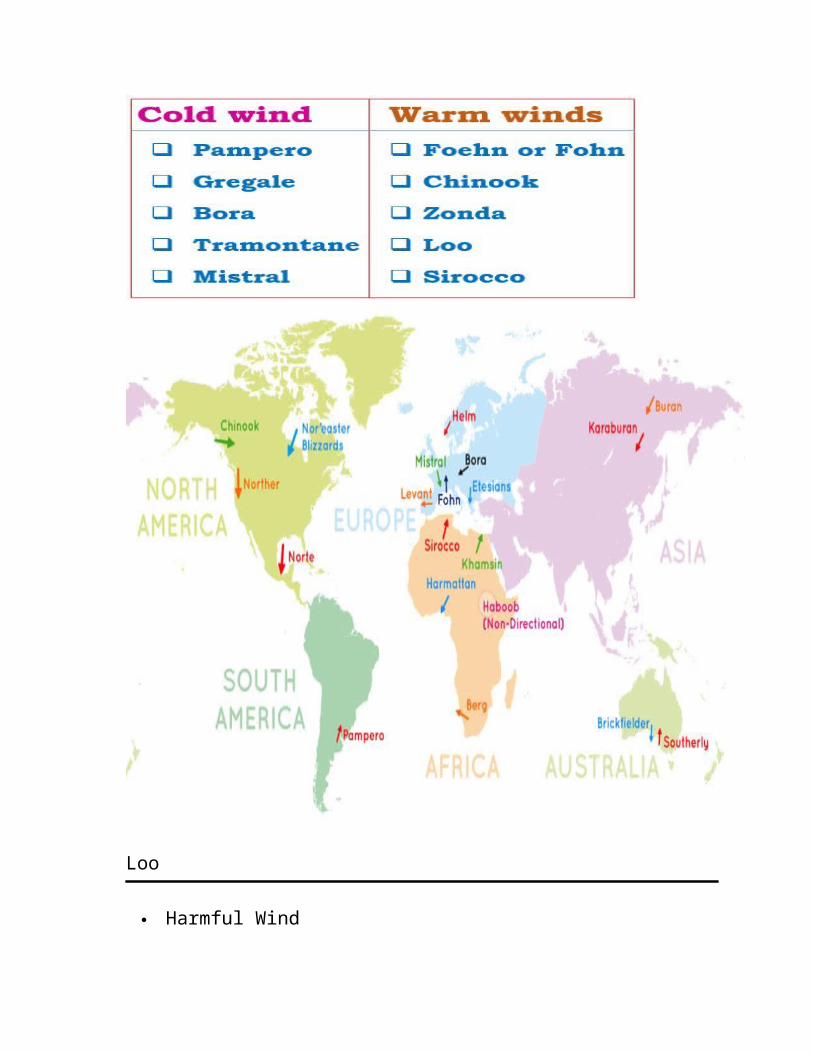
Tertiary Winds or Local Winds
Local differences of temperature and pressure produce local winds. Such winds are local in extent and are confined to the lowest levels of
the troposphere. Some examples of local winds are discussed below.
Loo
Harmful Wind
In the plains of northern India and Pakistan, sometimes a very hot and dry wind blows from the west in the months of May and June, usually in the afternoons. It is known as Its temperature invariably ranges between 45°C and 50°C. It may cause sunstroke to people.
Foehn or Fohn
Beneficial Wind Foehn is a hot wind of local importance in the Alps. It is a strong, gusty,
dry and warm wind which develops on the leeward side of a mountain range. As the windward side takes away whatever moisture there is in the incoming wind in the form of orographic precipitation, the air that descends on the leeward side is dry and warm (Katabatic Wind).
The temperature of the wind varies between 15°C and 20°C. The wind helps animal grazing by melting snow and aids the ripening of grapes.
Chinook
Beneficial Wind Foehn like winds in USA and Canada move down the west slopes of
the Rockies and are known as It is beneficial to ranchers east of the Rockies as it keeps the grasslands
clear of snow during much of the winter.
Mistral
Harmful Wind Mistral is one of the local names given to such winds that blow from the
Alps over France towards the Mediterranean Sea. It is channeled through the Rhine valley. It is very cold and dry with a
high speed. It brings blizzards into southern France.
Sirocco
Harmful Wind
Sirocco is a Mediterranean wind that comes from the Sahara and reaches hurricane speeds in North Africa and Southern Europe.
It arises from a warm, dry, tropical air mass that is pulled northward by low-pressure cells moving eastward across the Mediterranean Sea, with the wind originating in the Arabian or Sahara deserts.The hotter, drier continental air mixes with the cooler, wetter air of the maritime cyclone, and the counter-clockwise circulation of the low propels the mixed air across the southern coasts of Europe. The Sirocco causes dusty dry conditions along the northern coast of
Africa, storms in the Mediterranean Sea, and cool wet weather in Europe.
31.DBay of Bengal – DepressionCaribbean Sea – HurricanesAustralia - Willy willy
China -Typhoon
32. B pressure decreases with increasing altitude. The pressure at any level in the atmosphere may be interpreted as the total weight of the air above a unit area at any elevation. At higher elevations, there are fewer air molecules above a given surface than a similar surface at lower levels. Cold air exerts more pressure due to more number of molecules in the given space.
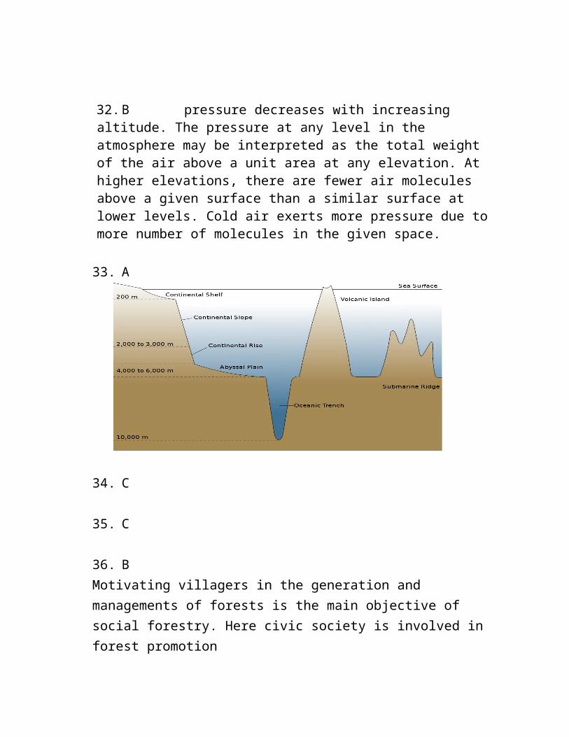
33. A
34. C
35. C
36. BMotivating villagers in the generation and managements of forests is the main objective of social forestry. Here civic society is involved in forest promotion
37. C
Siberian Climate – Cool Temperate Continental – Taiga Climate Cool temperate continental (Siberian) climate is only experienced in
northern hemisphere, where the continents within the high latitudes have a broad east west spread.
On its poleward side, it merges into Arctic tundra of Canada & Eurasia at around Arctic Circle;
Southwards, the climate becomes less severe & fades into the temperate Steppe climate
Predominant vegetation of this Siberian or sub-arctic type of climate is evergreen coniferous forests that stretch in a great, continuous belt across North America, Europe & Asia.
The greatest single band of the coniferous forest is Taiga (a Russian word for coniferous forest) in Siberia.
In Europe, this climate & forests are mainly confined to Northern Europe, Sweden & Finland;
However there are small amount of coniferous forests at high altitudes in Germany, Poland, Austria, Switzerland & other parts of the Europe.
In North America, the sub-arctic belt stretches across from Alaska across Canada into Labrador & is found in the high Rocky Mountains further south.
38. AThe Dead Sea is a salt lake bordered by Jordan to the east and Israel and Palestine to the west. Its surface and shores are 430.5 metres (1,412 ft) below sea level.It is Earth's lowest elevation on land. The Dead Sea is 304 m (997 ft) deep, the deepest hypersaline lake in the world. With a salinity of 342 g/kg, or 34.2%, (in 2011), it is 9.6 times as salty as the ocean and one of the world's saltiest bodies of water. This salinity makes for a harsh environment in which plants and animals cannot flourish, hence its name.It lies in the Jordan Rift Valley, and its main tributary is the Jordan River.
39. ATropical cyclones do not form near the Equator (within 5 degrees latitude) b/c the Coriolis force is 0 and air tends to flow straight into low pressure centers, so it feels up before the pr re can drop enough.
40. DSedimentary Rocks The word ‘sedimentary’ is derived from the Latin word sedimentum, which means settling. Rocks (igneous, sedimentary and
metamorphic) of the earth’s surface are exposed to denudational agents, and are broken up into various sizes of fragments. Such fragments are transported by different exogenous agencies and deposited. These deposits through compaction turn into rocks. This process is called lithification.(NCERT: Fundamentals of physical geography Page 42)41. AA mid-ocean ridge is an underwater mountain system formed by plate tectonics. It consists of various mountains linked in chains, typically having a valley known as a rift running along its spine. This type of oceanic mountain ridge is characteristic of what is known as an oceanic spreading center, which is responsible for seafloor spreading. The production of new seafloor results from mantle upwelling in response to plate spreading; this isentropic upwelling solid mantle material eventually exceeds the solidusand melts. The buoyant melt rises as magma at a linear weakness in the oceanic crust, and emerges as lava, creating new crust upon cooling. A mid-ocean ridge demarcates the boundary between two tectonic plates, and consequently is termed a divergent plate boundary.
42. AThe most abundant gas released from volcanic eruptions is water vapor. Other emitted gases include carbon dioxide (CO2), sulfur dioxide (SO2), hydrogen sulfide (H2S), carbon monoxide (CO), hydrogen chloride (HCl), and hydrogen fluoride (HF).
43. AA seamount is a mountain rising from the ocean seafloor that does not reach to the water's surface (sea level), and thus is not an island, islet or cliff-rock. Seamounts are typically formed from extinct volcanoes that rise abruptly and are usually found rising from the seafloor to 1,000–4,000 m (3,300–13,100 ft) in height. They are defined by oceanographers as independent features that rise to at least 1,000 m (3,281 ft) above the seafloor, characteristically of
conical form
44. APlayas are depressions formed due to deflating action of Winds.45. C Kalahari desert is a hot desert which is formed mainly due to its location in High pressure horse latitude zone.46. CChemical weathering is predominant in the humid regions of the globe. Water in fact acts as a catalyst to the process.47. DAll the given statements are correct regarding the jet streams48. A49. D50. BPrevious year question51. B
52. B Albedo
The fraction of Sun’s radiation reflected from a surface
Originated from the Latin word albus, meaning “white” It is quantified as the proportion, or percentage of solar
radiation of all wavelengths reflected by a body or surface to the amount incident upon it
53. A previous year upsc question54. A previous year upsc question55. B56. C
Viticulture is by tradition a Mediterranean occupation.Regions bordering the Mediterranean Sea account for three-quarters of the world’s production of wine.Some 85 per cent of grapes produced, go into wine.The long, sunny summer allows the grapes to ripen.
57. B58. C(correction: statement 4.Inland Fisheries are more significant than other types in India)59. A60. C61. B
62. C63. B previous year question
64. C
The Gutenberg discontinuity occurs within Earth's interior at a depth of about 2,900 km below the surface at boundary between Earth's mantle and outer core.
The Gutenberg discontinuity occurs within Earth's interior at a depth of about 2,900 km (1,800 mi) below the surface, where there is an abrupt change in the seismic waves (generated by earthquakes or explosions) that travel through Earth. At this depth, primary seismic waves (P waves) decrease in velocity while secondary seismic waves (S waves) disappear completely. S waves shear material, and cannot transmit through liquids, so it is believed that the unit above the discontinuity is solid, while the unit below is in a liquid or molten form. This distinct change marks the boundary between two sections of the earth's interior, known as the lower mantle (which is considered solid) and the underlying outer core (believed to be molten).
The molten section of the outer core is thought to be about 700°C (1,292°F) hotter than the overlying mantle. It is also denser, probably due to a greater percentage of iron. This distinct boundary between the core and the mantle, which was discovered by the change in seismic waves at this depth, is often referred to as the core-mantle boundary, or the CMB. It is a narrow, uneven zone,
and contains undulations that may be up to 5-8 km (3-5 mi) wide. These undulations are affected by the heat-driven convection activity within the overlying mantle, which may be the driving force of plate tectonics-motion of sections of Earth's brittle exterior. These undulations in the core-mantle boundary are also affected by the underlying eddies and currents within the outer core's iron-rich fluids, which are ultimately responsible for Earth's magnetic field.
The boundary between the core and the mantle does not remain constant. As the heat of the earth's interior is constantly but slowly dissipated, the molten core within Earth gradually solidifies and shrinks, causing the core mantle boundary to slowly move deeper and deeper within Earth's core.
The Gutenberg discontinuity was named after Beno Gutenberg (1889-1960), a seismologist who made several important contributions to the study and understanding of the Earth's interior. It has also been referred to as the Oldham-Gutenberg discontinuity, or the Weichhert-Gutenberg discontinuity.
65. C66. BConstant reversal of ocean currents is a characteristic feature of the Indian Ocean.67. B68. AAtmosphere gets heated due to the longwave emitted by the earth surface. The shortwaves of solar insolation do not heat the the atmosphere.69. B70. D71. CEarthquake is an endogenic activity.72. B73. D74. D75. C
76. ASea mount do not reach the surface of the ocean. They are formed due to volcanic eruption.
77. B78. A black sea is between Europe and Asia
79. A ( the question should be correct matched statement.)80. C81. C82. A83. A
Metamorphic Rocks
The word metamorphic means ‘change of form’. Form under the action of pressure, volume and temperature (PVT)
changes. Metamorphism occurs when rocks are forced down to lower levels by
tectonic processes or when molten magma rising through the crust comes in contact with the crustal rocks.
Metamorphism is a process by which already consolidated rocks undergo recrystallization and reorganization of materials within original rocks.
In the process of metamorphism in some rocks grains or minerals get arranged in layers or lines. Such an arrangement is called foliation or lineation.
Sometimes minerals or materials of different groups are arranged into alternating thin to thick layers. Such a structure in is called banding.
Gneissoid, slate, schist, marble, quartzite etc. are some examples of metamorphic rocks.
Causes of Metamorphism
Orogenic (Mountain Building) Movements
Such movements often take place with interplay of folding, warping, crumpling and high temperatures. These processes give existing rocks a new appearance.
Lava Inflow The molten magmatic material inside the earth’s crust brings the surrounding rocks under the influence of intense temperature pressure and causes changes in them.
Geodynamic Forces
The omnipresent geodynamic forces such as plate tectonics also play an important role in metamorphism.
On the basis of the agency of metamorphism, metamorphic rocks can be of two typesThermal Metamorphism
The change of form or re-crystallisation of minerals of sedimentary and igneous rocks under the influence of high temperatures is known as thermal metamorphism.
There may be various sources of the’high temperatures—hot magma, hot gases, vapours and liquids, geothermal heat etc.
A magmatic intrusion causing thermal metamorphism is responsible for the peak of Mt. Everest consisting of metamorphosed limestone.
As a result of thermal metamorphism, sandstone changes into quartzite and limestone into marble.
Dynamic Metamorphism
This refers to the formation of metamorphic rocks under the stress of pressure.
Sometimes high pressure is accompanied by high temperatures and the action of chemically charged water.
The combination of directed pressure and heat is very powerful in producing metamorphism because it leads to more or less complete
recrystallisation of rocks and the production of new structures. This is known as dynamothermal metamorphism.
Under high pressure, granite is converted into gneiss; clay and shale are transformed into schist.
Metamorphic Rocks in India
The gneisses and schists are commonly found in the Himalayas, Assam, West Bengal, Bihar, Orissa, Madhya Pradesh and Rajasthan.
Quartzite is a hard rock found over Rajasthan, Bihar, Madhya Pradesh, Tamil Nadu and areas surrounding Delhi.
Marble occurs near Alwar, Ajmer, Jaipur, Jodhpur in Rajasthan and parts of Narmada Valley in Madhya Pradesh.
Slate, which is used as a roofing material and for writing in schools, is found over Rewari (Haryana), Kangra (Himachal Pradesh) and parts of Bihar.
Graphite is found in Orissa and Andhra Pradesh.
84. C85. A86. C87. C88. C89. A90. A91. B92. D
93. B94. D95. C96. D97. C98. D
99. D100. B