Embed Size (px)
Citation preview
1
Council For Northeast Historical Archaeology Newsletter Number 104, October 2019
October 2019 Number 104
CONTENTS
UPDATE--Northeast Historical Archaeology 1NEWSLETTER EDITOR’S REPORT 3MINUTES CNEHA BUSINESS MEETING, HALIFAX, NOVA SCOTIA, October 21, 2018 3NEW PUBLICATION: Ramapough Lenape Heritage 8CURRENT RESEARCH New York 8 Delaware 10 Pennsylvania 13 Maryland 19 Virginia 19 Atlantic Canada 23MEMBERSHIP APPLICATION FORM
CNEHA Has a Permanent Address for Its Website:http://www.cneha.org/
COUNCIL FOR NORTHEAST HISTORICAL ARCHAEOLOGY
Chairman: Karen Metheny Newsletter Editor: David StarbuckP.O. Box 492, Chestertown, New York 12817-0492Tel.: (518) 494-5583 Email: [email protected]
Northeast Historical Archaeology seeks manuscripts dealing with historical archaeology in the Northeast region, including field reports, artifact studies, and analytical presentations (e.g., physical anthropology, palynology, faunal analysis, etc.). We also welcome commentary and opinion pieces. To submit a manuscript or request preparation of manuscript guidelines, write to Maria O’Donovan, Editor, Northeast Historical Archaeology, c/o Public Archaeology Facility, Binghamton University, Bing-hamton, NY 13902-6000. [email protected]
CNEHA Facebook PageCNEHA has a Facebook page! Log onto Facebook and then search for Council for Northeast Historical Archae-ology to see announcements about conferences and other updates.
You can join us on Twitter now too! @CNEHA_org
UPDATE —Northeast Historical ArchaeologyReported by: Maria O’Donovan
I can’t believe it has been almost three years since I began my tenure as editor! The learning curve has been a bit steep at times and I want to thank you for all your help and patience as I have settled into this role. There have been delays in production—Volume 47 with the thematic sect from the Smithsonian Environmental Research Center (SERC) will be out soon—and I am exploring several options to speed up the production process. I would welcome any input or suggestions that you have.
We have several thematic sections slated for publica-tion in the journal. Volume 48 will feature a thematic section on Fredericksburg, Virginia, with articles on the architecture of ice houses, tenant farms, stoneware ceramic repair, and slavery in an urban landscape. Con-tributed articles scheduled for publication in Volume 48 include a discussion of tavern assemblage patterning and window leads. A retrospective on archaeology at Strawbery Banke and a series of papers on working class heritage and community outreach will also be featured in future issues.
I hope to see all of you at the annual meeting in Lake George, NY. Please stop by and see me at the CNEHA table in the book room to chat about submitting your research for publication or any ideas you have for the journal. I will also have back issues of Northeast His-torical Archaeology and Telling Time posters available for purchase. If you miss me at the meeting, you can also purchase them by contacting me at [email protected] or visiting our web page at https://www.binghamton.edu/paf/neha.html.. Posters are priced at $10.00 each plus shipping and back issues of Northeast Historical Archaeology at $10.00-$13.00 plus shipping.
Email AddressesPlease update your email address (as necessary). You may do
this through the CNEHA website, http://www.cneha.org/
2
Council For Northeast Historical Archaeology Newsletter Number 104, October 2019
CHAIRKaren Metheny367 Burroughs Rd.Boxborough, MA USA 01719Home: (978) 263-1753E-mail: [email protected]
VICE-CHAIR
Meta Janowitz89 Moraine Rd.Morris Plains, NJ 07950Cell: (201) 738-1347E-mail: [email protected]
EXECUTIVE VICE-CHAIR (USA)
Ed MorinAECOM Technology Corporation437 High StreetBurlington, NJ USA 08016Work: (609) 386-5444E-mail: [email protected]
EXECUTIVE VICE-CHAIR (CANADA)
Joseph LastP.O. Box 1961Cornwall, ONCANADA, K6H 6N7Home: (613) 938-1242E-mail: [email protected]
TREASURER andMEMBERSHIP LIST
Sara Mascia 16 Colby LaneBriarcliff Manor, NY USA 10510E-mail: [email protected]
SECRETARYNancy J. Brighton24 Maplewood DriveParsippany, NJ USA 07054Work: (917) 790-8703Fax: (212) 264-6040E-mail: [email protected]
JOURNAL and MONOGRAPH EDITOR
Maria O’Donovan Public Archaeology FacilityBinghamton UniversityBinghamton, NY 13902-6000Work: (607) 777-4786Fax: (607) 777-2288E-mail: [email protected]
AT LARGE BOARD MEMBERS
Henry CaryPO Box 320520 Weldon StreetSackville, New BrunswickCANADA E4L 4N2Tel: (902) 523-0718Email: [email protected]
Amanda CromptonMax Planck Institute for the History of Science / Max-Planck-Institut für Wissenschaftsgeschichte Boltzmannstraße 2214195 Berlin, GermanyE-mail: [email protected]
Craig LukezicPatuxent River Base, MarylandWork: (301) 757-4774E-mail: [email protected]
Laura MasurDepartment of ArchaeologyBoston University675 Commonwealth Avenue, Suite 347Boston, MA 02215Work: (617) 358-1655E-mail: [email protected]
Stéphane NoëlDépartement des sciences historiquesPavillon Charles-De KoninckUniversité LavalQuébec (Quebec)CANADA G1V 0A6Work: (418) 656-2131, ext. 15144E-mail: [email protected]
Travis ParnoHistoric St. Mary’s CityPO Box 39St. Mary’s City, MD USA 20686E-mail: [email protected]
Meagan RatiniAECOM437 High StreetBurlington, NJ [email protected]
Patricia SamfordDirector, Maryland Archaeological Conservation LaboratoryJefferson Patterson Park & Museum10515 Mackall RoadSt. Leonard, MD USA 20685Work: (410) 586-8551 Fax: (410) 586-3643 E-mail: [email protected]
CNEHA EXECUTIVE BOARD 2019
Richard VeitMonmouth UniversityDept. of History and Anthropology400 Cedar AvenueWest Long Branch, NJ 07764-1898Work: (732) 263-5699E-mail: [email protected]
NEWSLETTER EDITOR
David StarbuckP.O. Box 492Chestertown, NY 12817Home: (518) 494-5583Cell: (518) 791-0640E-mail: [email protected]
3
Council For Northeast Historical Archaeology Newsletter Number 104, October 2019
NEWSLETTER EDITOR’S REPORTReported by: David Starbuck, Newsletter Editor
Please send me copy for the March 2020 issue (No. 105) of the CNEHA Newsletter by March 1 to ensure that the newsletter is ready to go on-line by late March.
Provincial Editors:
ATLANTIC CANADA: Amanda Crompton, Dept. of Archaeology, Memorial University of Newfoundland, St. John’s, Newfoundland, Canada A1C 5S7. [email protected]
ONTARIO: Eva MacDonald, 246 Sterling Road, To-ronto, Ontario, Canada M6R 2B9. [email protected]
QUEBEC: Stéphane Noël, Departement des sciences historiques, Pavillon Charles-De Koninck, Université Laval, Québec (Quebec), Canada G1V 0A6. [email protected]
State Editors:
CONNECTICUT: Cece Saunders, Historical Perspec-tives, Inc., P.O. Box 529, Westport, CT 06881. [email protected]
DELAWARE: Lu Ann De Cunzo, Dept. of Anthro-pology, University of Delaware, Newark, DEL 19716. [email protected]
MAINE: Leon Cranmer, 9 Hemlock Lane, Somerville, ME 04348. [email protected]
MARYLAND: Silas D. Hurry, Research and Collec-tions, Historic St. Mary’s City, P.O. Box 39, St. Mary’s City, MD 20686. [email protected]
MASSACHUSETTS: Linda M. Ziegenbein, Anthro-pology Department, University of Massachusetts, 215 Machmer Hall, Amherst, MA 01003. [email protected]
NEW HAMPSHIRE: Dennis E. Howe, 22 Union St., Concord, NH 03301. [email protected]
NEW JERSEY: Lynn Rakos, Housing and Urban De-velopment, Region 2, 26 Federal Plaza, Room 35-130, New York, NY 10278. [email protected]
NEW YORK CITY: Nancy J. Brighton, US Army Corps of Engineers, CENAN-PL-EA, 26 Federal Plaza, New York, NY 10278. [email protected]
NEW YORK STATE: Michael T. Lucas, Curator of Historical Archaeology, New York State Museum, CEC Room 3049, Albany, NY 12230. [email protected]
PENNSYLVANIA: Gary F. Coppock, Skelly and Loy, Inc., 449 Eisenhower Blvd., Suite 300, Harrisburg, PA 17111-2302. [email protected]
RHODE ISLAND: Kristen Heitert, The Public Archae-ology Laboratory Inc., 210 Lonsdale Ave., Pawtucket, RI 02860. [email protected]
VERMONT: Andrew Beaupré, PO Box 197, Hyde Park, VT 05655. [email protected]
VIRGINIA: Laura E. Masur, Archaeology Program, Boston University. [email protected]
WEST VIRGINIA: This position is now open. If you are interested, please contact David Starbuck.
MINUTESCNEHA BUSINESS MEETING
HALIFAX, NOVA SCOTIAOctober 21, 2018
Sunday, October 21, 2018, Halifax, Nova Scotia, 7:49AM
Approval of the minutes from the 2017 annual business meeting held on Sunday, November 12, 2017 in Ottawa published in the March 2018 newsletter.
Motion to Accept the 2017 Business Meeting Minutes: Mary BeaudryMotion 2nd: Richard Schaefer
The motion carried unanimously.
Old Business 1. Chair’s report: Karen Metheny
The organization continues to focus on advocacy, mem-bership and communicating with members on develop-ing programs.
2. Secretary Report: Nancy Brighton
Nothing to report
3. Treasurer’s report:
a. Overall Finances and US Account: Sara Mascia
The starting 2018 balance was $14,539 with expendi-
4
Council For Northeast Historical Archaeology Newsletter Number 104, October 2019
tures totaling $ 7,066 and income of $ 7,472. There is $27,500 in the checking account with $10,000 in a reserve fund investment CD that matures in September and will be used for the publication of future journals.
b. Canadian Account: Joe Last
The 2018 starting balance was $5,529.83. Credits in-clude $2,013.45 from membership and $3,000.50 from US funds for the journal. Total revenue is $5,013.95. Expenditures include $335.61 for postage and stationary supplies (printer ink, etc.). The current 2018 balance is $10,208.17. There are still anticipated expenditures for the printing and mailing of the journal.
Motion to Accept the Treasurer’s Report: Alison BainMotion 2nd: Steve Oberon
The motion carried unanimously.
3. Membership reports:
a. Individual US: Sara Mascia for Ed Morin Total membership includes 254 members, including Canada. The total membership consists of 125 indi-vidual, 24 student, 22 joint, 16 fellow, 17 retired, 18 institution, and 3 business.
Overall membership is lower than it has been in pre-vious years. The organization needs to recruit new members and improve number by 50 members.
b. Individual Canadian: Joe Last
Membership numbers, as of October 9, includes 107 to-tal members, consisting of 53 individuals, 18 students, 12 joint, eight fellow, six life, nine business/institution, and one retired. The breakout of members by province indicates there are two members from Alberta, five from New Brunswick, 16 from Newfoundland, 21 from Nova Scotia, 15 from Quebec and a single member from Prince Edward Island. Joe ended his report with a thank you to the professors who bring or encourage their students’ participation in the conferences.
4. Publications and communications reports:
a. Newsletter: David Starbuck
Two newsletters were put out – one in March and one in June. The October newsletter is waiting to go as soon as some additional copy is received. Anyone with copy should send it to David by October 26. David noted that some states and provinces never submit copy – the same two or three editors usually submit copy for the newsletters.
Over the past year, no copy was received for 10 states and provinces. David will contact the editors to see if they still want to be editors. New editors are needed for Virginia and West Virginia. Anyone who is interest-ed in acting as an editor for those states should contact David.
b. Journal: Maria O’Donovan
Maria thanked the membership for its patience with delay of Volume 46 on Philadelphia Queensware. It is currently being printed and will be mailed out short-ly. Volume 47 is in production with articles from the Smithsonian Environmental Research Center on land-scape and the environment, as well as other articles on butchery and smoking pipes.
Maria thanked editorial assistants Catherine Seibert and Jesse Siegel for getting Volume 46 out after working in the field over summer.
The journal is in good financial health. There have been some excellent papers given at the conference and these papers should be submitted to the journal. The conference is where we share our work with each other. The journal is where we get the word out. It’s a well-respected publication and the journal office is easy to work with. If anyone has seen papers that should be worked into an article, put a suggestion in the bag on the back for Maria to solicit from the presenters.
Karen congratulated Maria and journal staff on their first issue coming out this year.
c. Web page: Silas Hurry
Karen thanked and said good-bye to Silas as web coordinator. Silas was thanked with round of applause. Silas noted it was an easy job as web master, Christy Morgenstern, is wonderful. Travis Parno will be taking over as the liaison – contact him for content.
d. Social Media: Christa Beranek
Christa thanked the conference committee for its use of social media for promotion. CNEHA has a Facebook, Twitter and Instagram accounts - the latter formed by conference committee. Check social media for con-ference updates. Travis is contact for twitter. Contact Christa or Laura for Facebook posts, such as historic photos of past conferences or upcoming events, etc.
5. Programs and Meetings:
a. 2018 Halifax, Nova Scotia:

5
Council For Northeast Historical Archaeology Newsletter Number 104, October 2019
The organizers thanked everyone for coming and thanked all of the volunteers. They hope everyone had a good time in Halifax. They had set a goal of 150 del-egates to the meeting and, as of yesterday, there were 145 delegates. The conference had great support from local companies especially the regional archaeological companies. The organizers raised $24,500 and were able to accomplish many things for the conference. Finally, the organizers thank the presenters for all of the papers – it’s always great to get archaeological minds together.
b. 2019 Lake George/Fort William Henry: David Starbuck
David is looking forward to seeing everyone in Lake George, NY – it’s a great location. Fort William Henry has hosted New York State meetings in the past. The current plan is to have an all-day tour of military sites in the region. There will also be a tour of Adirondack Iron and Steel Company and possibly stop at the Star-buck farm to see the farm exhibits
Phil Dunning will conduct a workshop entitled “Alco-hol and the Army”. It will be a great venue. The dates are November 7-10, 2019. It is a little late because October has a number of competing events upstate and November will get everyone the off-season rate.
c. 2020 Plymouth, MA/joint meeting with SHA/SPMA for 400th anniversary of Plymouth Colony: Karen Metheny
Negotiations for a contract in Plymouth, Massachusetts, for November 5-8, 2020 is ongoing. David Landon and Christa Beranek will be co-hosting with Karen. We will be inviting the Society for Historical Archae-ology and the Society for Post-Medieval Archaeology to attend for the 400th anniversary of the founding of Plymouth colony and the effects of colonization. This will be the second event, as there will be one in Plym-outh, UK. The team is working with Plymouth 400 Committee, Historic Plimouth and the Wampanoag to create events. There is also an on-going investigation in downtown Plymouth.
d. Future Conferences St Mary’s City in 2021 and possibly Montreal in 2022: Karen Metheny
There is the potential to return to St Mary’s City in 2021 and we are looking for a Canadian team to set up a meeting in Montreal for the following year.
6. Student Paper Competition: Nancy Brighton
There were four students who entered this year’s stu-dent paper competition. They are:
John Archer, Memorial University, who gave a paper on Ferryland entitled “The First Foundation of a Good House: Examining Ferryland’s Mansion House Kitch-en”
Meghann Livingston, Memorial University, “’From the Sea, Work’: Investigating Landscape and Lifeways at Anse a Bertrand, Saint-Pierre et Miquelon, 1670-1970”
Alex Spiwak, Memorial University, “’A slator or two’: Exploring the 17th century slate industry at Ferrylan-dand”
Solene Gauthier, Laval University, “Seed and Insects in an Early 19th Century Privy: (Unchanging Foodways During Quebec City’s Golden Age”
The winner is Alex Spiwak for her paper that analyzed roof slate – looking at processing and finishing tech-niques in a unique look at early colonial architecture.
Alex will receive $100 and a paid 2019 membership.
7. Poster Competition:
Public Education Poster Session on Collaborative Science: Karen Metheny
The winner of the poster session is RMC volunteer research group. Each of the authors will receive a cer-tificate and each of the authors will receive one bottle of Hunky Dory beer.
8. Education and Outreach
Professional enrichment program (Geomatics and GIS): Karen Metheny
A professional enrichment program on Geomatics and GIS was offered as a full-day workshop. Each par-ticipant received a certificate. The Board is accepting recommendations for future workshops.
Recruitment/student members/young professionals: Stéphane Noël Sixty-six people responded to the membership survey and the data is being analyzed for a future presentation in the newsletter. The goal of this survey is to identify what we do well and what we can improve. We hope to use the survey to develop ideas to recruit new mem-bers. In particular, we look to use social media even more and to market CNEHA even more to show what we do and what we are about.
Most noted the congeniality of the organization and its
6
Council For Northeast Historical Archaeology Newsletter Number 104, October 2019
human side. Eighty percent of respondents heard about CNEHA from professors or colleagues.
As a way to get members to respond, a prize, consisting of a one-year membership, was being offered to a ran-domly drawn name of those responding. The winner is Rob Ferguson.
New Business
1. Nominations and Elections Committee: Nancy Brighton
For this year’s election we used Survey methods. It allowed for a greater response (more the 100 respons-es) but it has limited reporting without paying addi-tional fees. A total of 60 people responded; the median response time was 35 seconds. The result was the re-election/election of Joe Last, Sara Mascia, Laura Masur, Karen Metheny and Richard Veit to the Board.
At Thursday night’s Board meeting, Karen Metheny was re-elected as Chairperson, Sara Mascia was re-elected as Treasurer and Joe Last was re-elected as Vice-Chair for Canada.
2. Other new business
a. Resolution of Thanks to the Conference Committee: Nancy Brighton
Good Morning. Whereas, the 2018 Council for North-east Historical Archaeology Conference has been a resounding success;
Whereas, Halifax has once again proven to be a most spectacular venue for a conference; and
Whereas, we have all enjoyed the informative tours of the Albion Mines Foundry Site in Stellarton and walking tours of Halifax and workshops on Geomatics and GIS, Artifact Photography, and Mapping Sites with Magnetic Susceptibility; and
Whereas, the Lord Nelson Hotel has provided welcom-ing venues for toasts and talks; and
Whereas, the entire conference has been conducive to the dissemination of knowledge and stimulating exchange of ideas;
Now therefore let it be resolved that the Council for Northeast Historical Archaeology wishes to express its appreciation and gratitude for all of the hard work, long hours and spectacular effort of the conference commit-tee:
Catherine Cottreau-Robins and Jonathan Fowler, Conference Co-Chairs April MacIntyre, Program Chair Courtney Glen and Darryl Kelman, Program Committee Rob Ferguson, Registration Chair Denise Hansen and Janet Stoddard, Registration Committee Sara Beanlands, Catherine Cottreau-Robins, Jonathan Fowler and Jeff Turner, Finance and Corporate Sponsorship Committee Jonathan Fowler and Sarah Ingram, Conference Website and Social Media Vanessa Smith and Laura De Boer, Book Room, Raffle and Poster Competition Committee Kiersten Green and Sarah Ingram, Volunteer Coordination and Beer Social Committee Catherine Cottreau- Robins for the Logo Design; and Laura de Boer for the T-shirt Design Workshop Leaders and Tour Guides: Greg Baker Troy DeSouza Jonathan Fowler Duncan McNeill Vanessa Smith Laura De Boer, for her tour of the Albion Mines and David Jones for his enthusiastic and passionate walking tours of Halifax
To all of the volunteers and students who have provid-ed invaluable support and general go-fer services to ensure the conference ran smoothly
To the Sponsors for their extremely generous financial and other support, including: Beta Analytic Testing Laboratory Boreas Heritage The Cultural Resource Management Group Davis Macintyre and Associates Kelman Heritage Consulting Killam Apartment Reit Lalonde AMS New Brunswick Canada Nova Scotia Power Sensors and Software Saint Mary’s University
To Paul Cheetham, Bournemouth University for his thoughtful and humorous keynote address and the Gar-rison Brewing Company for an excellent reception site on Friday Night.
7
Council For Northeast Historical Archaeology Newsletter Number 104, October 2019
To the staff of the Maritime Museum of the Atlantic for the Saturday night “banquet.”
To the Fine Tuners for their toe-tapping entertainment
To the session chairs, who have kept or will keep their sessions organized or running on time: Sara Beanlands Stephen Davis Rebecca Dunham Karen Metheny Keith Mercer Stéphane Noël Travis Parno, and Barry Gaulton
To all the contributors to the raffle and the staff of the Lord Nelson Hotel for excellent and expeditious service,
Let us give a round of applause for the organizers, students, presenters and supporters of this wonderfully informative and most enjoyable conference.
b. Resolution of Thanks to Outgoing Board Member Christa Beranek: Karen Metheny
Whereas the term of office for a member of the Exec-utive Board for the Council for Northeast Historical Archaeology is expiring, the Council acknowledges and appreciates the contribution of Christa Beranek;
Christa has served three terms on the Board and has been a vital member of several committees including the Nominating Committee and the Journal Advisory Committee. During her tenure she also assisted with the Student Paper Competition and was instrumental in creating and administering the CNEHA Facebook page while working with the Publications Committee on Social Media.
Although leaving the board, Christa will be working with the 2020 Conference Committee on our future meeting in Plymouth, Massachusetts.
Now, therefore be it resolved the Council expresses its sincere appreciation and thanks Christa with a round of applause.
c. Resolution of Thanks to Outgoing Web Coordinator Silas Hurry: Sara Mascia
Good Morning. It is my pleasure to acknowledge the hard work and dedication of outgoing web coordina-tor, Silas Hurry. Silas’ most significant contribution to CNEHA has been to expand CNEHA’s public and
membership outreach through the Internet. Silas almost singlehandedly brought CNEHA into the digital age. He not only designed the Council’s first website but arranged with St. Mary’s College to host the site for many years. As CNEHA’s Webmaster, Silas duti-fully maintained the site at the college and then helped to shepherd the site to its current location in 2000. He helped to create online tools for membership and con-ference registration, as well as other online features and resources for CNEHA’s membership. He has helped CNEHA to not only expand its digital presence but to envision the website as a means of fostering new con-nections and new interest in the work of archaeology.
The Council hereby acknowledges and appreciates the long-term and unfailing contributions of Silas Hurry as web coordinator.
Let it be resolved:
Whereas, Silas Hurry served for many years as CNE-HA’s webmaster when the website was first created at St Mary’s City and continued to serve as web coordina-tor when the website switched to its own domain;
Whereas, under his guidance, the CNEHA website expanded to include registration, membership, archives of past meetings, access to the entire run of newsletters, and gallery photos of conference attendees;
Whereas, Silas faithfully submitted a report on website usage twice a year, served as an excellent liaison with our web site host, implemented the board’s suggestions for improvements as well as many of his own recom-mendations, and turned our website into a site on which we continue to rely and of which we are justly proud;
Whereas, he is stepping down from his position of web coordinator;
Therefore, let the Council express its sincere apprecia-tion for his long years of service and show our thanks with a hearty round of applause for Silas.
Motion to Adjourn the meeting was made by Sara Mascia.
Motion 2nd: Maria O’Donovan
The meeting ended at 8:31AM
Respectfully submitted,
Nancy J. BrightonSecretary
8
Council For Northeast Historical Archaeology Newsletter Number 104, October 2019
NEW PUBLICATION
The North Jersey Highlands Historical Society is pleased to announce publication of:
RAMAPOUGH LENAPE HERITAGE:ARCHAEOLOGY, HISTORY & CULTURE:
10,500 B.C. TO THE PRESENT
By Edward J. Lenik
With the publication of his fourth book on the Ra-mapough Lenape people of northern New Jersey and southeastern New York, archaeologist Edward J. Lenik celebrates a half century of research and investigation. Ramapough Lenape Heritage focuses on the archaeo-logical evidence of continuous indigenous occupation Lenik and others have uncovered from early 20th century explorations by amateur archaeologists to the careful, scientific excavations and analyses of the late 20th and early 21st century professionals like himself. Much of the material in this book can be found only in cultural resource studies filed in New York and New Jersey state repositories.
The Stag Run Village site, the Trading Post site, the Sheffield Farm House site, the Indian Field Village site, Mountainside Farm and numerous open-air campsites, workshops, lithic scatter and quarry sites are discussed. The mysterious Prehistoric Walls site in Sloatsburg, NY, is presented in detail with new insights. Halifax or Green Mountain Valley in Mahwah, NJ, is examined both archaeologically and historically using census data to identify some of its former occupants.
The 280-page book, printed in color, features 13 tables and 128 illustrations including photographs, maps, field sketches and drawings.
Ramapough Lenape Heritage can be purchased for $20 from the North Jersey Highlands Historical Society Bookshop at Ringwood Manor State Park or can be or-dered by sending a check for $20 plus $4 shipping and handling to North Jersey Highland Historical Society (NJHHS) at P.O. Box 248, Ringwood, NJ 07456.
Lenik’s 3 previous volumes are also available:
Indians in the Ramapos. Survival, Persistence and Presence (1999) $10
Ramapough Mountain Indians: People, Places and Cultural Traditions (2011) $20
Keepers of the Pass, The Ramapough Lenape Indians (2016) $20
CURRENT RESEARCH
New York StateReported by: Michael Lucas
Western New York[Submitted by Ryan Austin]
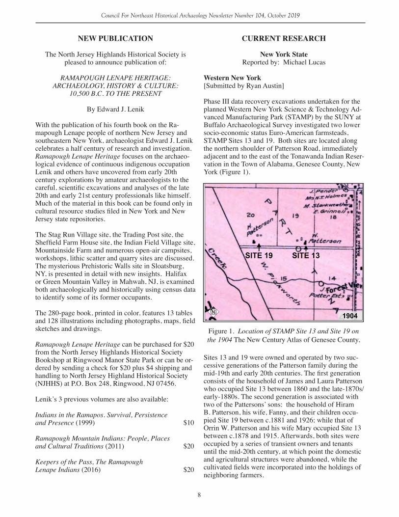
Phase III data recovery excavations undertaken for the planned Western New York Science & Technology Ad-vanced Manufacturing Park (STAMP) by the SUNY at Buffalo Archaeological Survey investigated two lower socio-economic status Euro-American farmsteads, STAMP Sites 13 and 19. Both sites are located along the northern shoulder of Patterson Road, immediately adjacent and to the east of the Tonawanda Indian Reser-vation in the Town of Alabama, Genesee County, New York (Figure 1).
Sites 13 and 19 were owned and operated by two suc-cessive generations of the Patterson family during the mid-19th and early 20th centuries. The first generation consists of the household of James and Laura Patterson who occupied Site 13 between 1860 and the late-1870s/early-1880s. The second generation is associated with two of the Pattersons’ sons: the household of Hiram B. Patterson, his wife, Fanny, and their children occu-pied Site 19 between c.1881 and 1926; while that of Orrin W. Patterson and his wife Mary occupied Site 13 between c.1878 and 1915. Afterwards, both sites were occupied by a series of transient owners and tenants until the mid-20th century, at which point the domestic and agricultural structures were abandoned, while the cultivated fields were incorporated into the holdings of neighboring farmers.
Figure 1. Location of STAMP Site 13 and Site 19 on the 1904 The New Century Atlas of Genesee County,
9
Council For Northeast Historical Archaeology Newsletter Number 104, October 2019
Data recovery excavations studied the partially-intact stone foundation pits of each site’s farmhouse and barn outbuilding(s), wells and fence-lines, as well as identified and sampled domestic sheet midden scatters and buried refuse pit features found in the surrounding yard areas. Artifacts recovered from Site 13 suggest that the first generation Patterson household spent most of its available funds on farmstead improvements, as opposed to the acquisition of portable material culture such as ceramic or glass wares that could be used to display notions of social status. Food related ceram-ics included the lowest-cost decorative wares, such as shell-edged or annular banded vessels, as well as non-matching higher cost transfer-printed wares that may have been purchased piecemeal.
Instead of the purchase of status items and additional farmland, including the purchase of lands that would later be incorporated into Site 19, Site 13’s first oc-cupation household improved their farmstead’s infra-structure. This included the construction of a shed-type addition along the barn’s eastern façade used to house animals, as well as the construction of a fenced pad-dock that was watered with its own well. The majority of household trash was discarded in the farmhouse’s immediate perimeter, particularly in its front and rear yards. This deposition occurred as a result of the broadcast discard of household refuse through open windows or doorways directly onto the ground surface. It also appears that the Site 13 occupants did attempt to periodically sweep away surface debris from the house’s northern yard where it accumulated along the fenced margins.
During the second-generation occupation at Sites 13 and 19, both Patterson brothers’ farms were semi-sub-sistence operations employing different production strategies from that of their parents. Unlike James and Laura, who had able-bodied adult sons, neither Hiram nor Orrin had male children who could contribute man-ual labor, and therefore had to supplement their own labor with that of non-family farm laborers. Hiram and Orrin themselves continued to farm into old-age and neither brother passed their farms on to their children. It is also possible that the declining local agricultural economy of the late 19th and early 20th centuries, com-bined with the marginal nature of the farmland, made the prospects of future agricultural work unattractive to the next generation.
Several other comparisons can be made regarding both sites’ second-generation occupations. In terms of structural remains, both farmhouses have mortared cobblestone foundation walls covered with concrete parge coats, and both houses have a cistern built into their foundation pits that was coated by a water-proof concrete lining. However, Site 13’s farmhouse appears
to have a cruder-built foundation, with individual building stones being non-uniform in size and shape. The surviving walls are roughly/unevenly built, and following the erosion of the mortar, have slumped into the foundation pit’s open base. Conversely, Site 19’s farmhouse has foundation walls built from dressed stones that were selected for both shape and uniformity, and their mortar bindings have remained intact.
Machine-cut nails recovered from both sites indicate that the farmhouses were balloon-framed structures. However, it should be noted that there are far more cut nails at Site 19, many of which are uniform in size and shape and are specialized for carpentry or finishing work. Also, there are more wire nails at Site 19, as well as more window glass by volume. While it is possible that the construction-related debris recovered during Site 19’s second occupation period is related to the construction of the house’s banked northern wing, it is also possible that these materials reflect a general im-provement in house construction techniques developed during the late 19th century.
In terms of portable material culture, the second gen-eration occupants of both sites used similar domestic ceramic and glass vessels, some of which may have been originally acquired and used during Site 13’s first generation occupation and were later curated by members of both sites’ second generation households. Both sites’ second-generation occupations also appear to have continued to use ceramic food storage vessels, even after glass canning jar technology became more widely available during the late 19th/early 20th cen-turies. Moreover, both sites’ second-generation house-holds purchased and used undecorated and lower-cost annular banded and shell-edged decorated wares, while more expensive transfer-printed and polychrome decal-decorated vessels appear to have been acquired sporadically as non-matching single items.
Moreover, both second generation Patterson households continued to dispose of household refuse in broadly scattered surface sheet middens located immediately adjacent to living and working spaces well into the 20th century. However, it appears that Orrin W. Patterson’s household at Site 13 made more of an effort to segre-gate their trash into a relatively discreet refuse scatter located within the barn yard margins. In contrast, the bulk of Hiram B. Patterson’s household refuse disposal at Site 19 occurred within the farmhouse’s immediate perimeter.
Both Site 13 and Site 19 retain archaeological integrity and document rural lifeways and consumer behavior during the late 19th and early 20th centuries in rural western New York. A final report on the 2018 data recovery investigation is in progress.
10
Council For Northeast Historical Archaeology Newsletter Number 104, October 2019
DelawareReported by: Lu Ann De Cunzo
Colonial Delaware Archaeology Project[Submitted by: Lu Ann De Cunzo]
During Spring semester 2019, the University of Del-aware (UD) Anthropology Department collaborated with the Archaeological Society of Delaware (ASD) to advance the Colonial Delaware Archaeology Project. This new collaboration uses archaeological techniques to learn more about the encounters among Lenape, Susquehannock, European, and African peoples in the lower Delaware Valley in the seventeenth and early eighteenth centuries.
The project started as a collaboration between UD Anthropology and the Delaware Division of Historical and Cultural Affairs (DHCA) in 1992. DHCA funded a location and identification survey along the Appoqui-nimink and Drawyers Creek drainages from Delaware Bay to Route 13, with a focus on early colonial sites. We found a partner in Mr. John Coleman, local farm-er and avid avocational archaeologist. He generously shared his multi-generational knowledge of his family farm, and his extensive collections of artifacts assem-bled from decades of field-walking. With Mr. Cole-man’s guidance and support, the UD and ASD team examined the area that has yielded the greatest con-centration of seventeenth and early eighteenth-century materials.
William Warner was granted a 400-acre parcel along the Appoquinimink Creek in 1671. The property stood not far from the Susquehannock trading post estab-lished to facilitate trade across the Delmarva peninsula and along the Delaware coast. Warner sold the tract to Hans Hanson who grazed cattle on the marshland and built a water mill nearby with his neighbors. In 1679, Hendrick Williams purchased the plantation, a success-ful New Castle merchant. At his death in 1694, his son inherited the Appoquinimink plantation on which he raised livestock. The property remained in the Williams family until 1760, when yeoman Edmond Liston and his wife Rachel Farson purchased it. The farm passed in the Liston family for several generations. The Cole-mans moved to the farm in the World War II era.
Under the direction of Dr. Lu Ann De Cunzo, UD Anthropology, UD archaeology staff, and professional archaeologists active in ASD, UD students enrolled in an introductory archaeological field methods course partnered with ASD members seeking training and ex-perience. Following an introductory orientation session, team members surveyed in a grid, located, mapped and collected hundreds of metal detecting ‘hits’ and surface artifacts and excavated 60 STPs and four larger exca-
vation units. Soil scientist Philip King, USDA, donated time and equipment to complete a GPR survey of the area, locating two anomalies. Curtis McCoy, Dovetail CRG and ASD chapter president, directed site survey and mapping, and produced GIS distribution maps to guide future research. The collections will be pro-cessed, analyzed, curated and returned to the Colemans to stay with the farm.
The fieldwork produced native lithic tools and debitage, nails, redwares, and other pre-Revolutionary ceramics and small finds documenting thousands of years of set-tlement on the ridge overlooking the creek and marsh. A possible cellar or well filled in the 18th century and stone fill stabilizing a possible landing will number among the targets of additional research. UD and ASD plan to engage the larger community in future projects.
Tri-Valley Trail at White Clay Creek State Park[Submitted by: Bill Liebeknecht, MA, RPA and Curtis McCoy, MS, RPA
In 2017, on behalf of the Cultural Resources Unit of the Delaware Division of State Parks and Recreation, Department of Natural Resources and Environmental Control (DNREC), Dovetail Cultural Resource Group (Dovetail) conducted a Phase I-level archaeological survey for the proposed construction of the Tri-Val-ley Trail at White Clay Creek State Park in Newark, Delaware (Chase and Liebeknecht 2017). The project corridor is 6,020-feet (1,834.9 m) in length.
The project’s aim was to identify any archaeological resources within the project’s area of potential effects (APE) that may be affected by the proposed undertak-ing. All identified resources were then evaluated to pre-liminarily establish the extent and potential significance of the resource for listing in the National Register of Historic Places (NRHP) per the Criteria of Evaluation (36 CFR 60) for purposes of project planning and re-source management.
The Phase I-level archaeological survey identified no new resources within the project area that meet the Del-aware Division of Historical and Cultural Affairs State Historic Preservation Office (DE SHPO) threshold for archaeological sites in the state. It did, however, expand the identified limits of the Newark China Company site (N09354/7NC-D-277). The factory complex was active from 1912 to 1942. The factory complex consists of numerous foundations for the processing of kaolin clay, stockpiled materials (sand, mica and kaolin clay), and hand-dug clay mining pits (now filled with water). The project area was photo-documented, and a rough map was created taking two GPS points from the corners of all structures observed. All buildings were then manual-ly measured using hand reel tapes and cross-referenced
11
Council For Northeast Historical Archaeology Newsletter Number 104, October 2019
Map of the Newark China Clay Company Complex on LiDAR Hillshade (FirstMap 2017).
12
Council For Northeast Historical Archaeology Newsletter Number 104, October 2019
Detailed Map of the Newark China Clay Company Complex on LiDAR Hillshade (FirstMap 2017).
13
Council For Northeast Historical Archaeology Newsletter Number 104, October 2019
with a map based on an interview with a former factory worker.
Once numerous operations such as this are a forgot-ten part of the modern landscape. The Newark China Clay Company is one of only a handful of intact clay mining complexes in the northeast. Typically these sites were blended back into the landscape following closure of the mines so that the land could be reused. Dovetail recommended that the Newark China Clay Company (7NC-D-277) was potentially eligible for listing in the NRHP under Criteria A, C, and D for its association with the local community’s developmental history, the development of the kaolin clay industry and establishment of industrial areas outside of nearby city centers in the early-twentieth century, the presence of intact building remains and associated landscape, and its potential to yield further information on area history pending additional archaeological study. Dovetail fur-ther recommended extensive clearing of the understory followed by detailed mapping of the numerous founda-tions, features and former industrial landscape associ-ated with the Newark China Clay Company before the Tri-Valley Trail was to be constructed.
Intense clearing revealed more than we could have hoped for, including a 6 to 8-foot tall stockpiled mound of raw kaolin clay, washing troughs, iron hoops from settling large barrels and an iron timber bucket which was used to lower men down into the pits in the morn-ing (and out at the end of the day), lower timbers down into the pit for shoring, remove water and to haul clay from the pits. Clearing allowed for detailed mapping
which was then geo-referenced to a Lidar map of the area. An article on the kaolin industry in Southeast Pennsylvania and North Delaware will be forthcoming in Pennsylvania Archaeologist.
References Cited:Chase, Kristine A. and William B. Liebeknecht2017 Phase I Archaeological Survey of Phase II of the Trivalley Trail, White Clay Creek State Park, City of Newark, Delaware. Dovetail Cultural Resource Group, Wilmington, Delaware.
FirstMap2017 Delaware Lidar DEM. Electronic document, https://firstmap.gis.delaware.gov/arcgis/rest/services/Elevation/DE_Lidar_DEM/ImageServer, accessed August 2017.
PennsylvaniaReported by: Gary Coppock
Archaeology in Action as Veterans Outreachat Fort Ligonier[Submitted by: Angie Jaillet-Wentling, PennDOT]
On August 3 and 4, 2019, Fort Ligonier (36WM0071) hosted two veterans groups in an outreach program put together by Dr. Jonathan Burns, Juniata College, Cultural Resource Institute, Angie Jaillet-Wentling, PennDOT, and Schott Shaffer, PennDOT. On Satur-day, volunteers from Team Rubicon (veterans and first responders focusing on disaster relief) and their fami-lies helped to excavate portions of a trench measuring
Figure 1. Laying out and explaining the research goals for the event, Dr. Burns and Scott Shaffer explain techniques to the volunteers. (Pho-to by Michelle Ufner)
14
Council For Northeast Historical Archaeology Newsletter Number 104, October 2019
50-cm by 5-meters and helped metal detect to try to aid in the attempts to locate one of the artillery batteries or the line of communication. On Sunday, volunteers from The Mission Continues (a veterans service organiza-tion) helped screen, map, and backfill the excavations. Most of the recovered artifacts appear to date to the 20th and 19th centuries and were recovered from the A horizon. Both bedrock and fill deposits were encoun-tered with some indications that disturbances may be related to the late 20th century amphitheater seating known to have been in the area. A total of approximately sixteen volunteers were pres-ent on Saturday and ten on Sunday with a number of curious museum and site visitors stopping by. At least one young aspiring kindergartner/archaeologist brought along his Mickey Mouse adventure kit complete with a trowel and pick. Team Rubicon volunteer Timothy Smith, Master Sergeant, US Air Force (Retired), wrote to express his thanks saying, “I for one had an absolute BLAST.” On leaving the site Sunday afternoon, the volunteers were invited to attend a lecture by US Army veteran and artist-in-residence, Elise Wigle-Wells, who created a number of pieces as part of her work entitled HER, focusing on the timeless experiences of women in war and conflict, and featured throughout the fort’s spaces.
Between the unfailing support of Fort Ligonier staff, collaboration between professional and avocation-al archaeologists, and the positive experiences and reactions from the veterans groups, we hope to do it again! Looking forward to next year, Dr. Burns plans to return with a field school for students in the summer as
part of ongoing research. Additionally, we’re hoping to host more veterans on-site in the coming years as part of the ongoing public and veterans outreach efforts. This year’s event was covered by Pittsburgh’s Tribune Review (TribLive) https://triblive.com/local/westmore-land/veterans-help-with-archaeological-dig-at-fort-ligo-nier/.
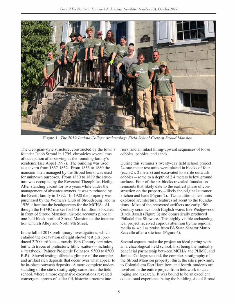
An Update on the Archaeology Field School at Stroud Mansion[Submitted by: Jonathan A. Burns, Juniata College]
The Juniata College undergraduate archaeology field school was conducted at Stroud Mansion in conjunc-tion with the Monroe County Historical Association (MCHA) from June 17 to July 7, 2019 (Figure 1). The partnership materialized from the MCHA’s desire to evaluate the potential for below ground cultural re-sources in the yard of their property at Stroud Mansion (36MR0290), located at 900 Main Street, Stroudsburg, Pennsylvania. Our goal was to assist with the inves-tigations and mitigation of extant cultural resources such as Stroud Mansion’s outbuildings, Fort Hamilton (1756-1757), or potentially much older prehistoric Na-tive American occupations. Funded in part by a PHMC Keystone grant, the project serves as a model for efficient collaboration between the non-profit, the state agency, and a private liberal arts college. Nine under-graduate students were trained in basic field methods while excavating test units under the supervision of Professor Jonathan Burns (Juniata College) and two graduate Teaching Assistants, Haley Hoffman (William and Mary College) and Charles Edwards (Indiana Uni-versity of Pennsylvania).
Figure 2. Team Rubicon volunteers and family members sift soils from the trench excavation. (Photo by Michelle Ufner)
15
Council For Northeast Historical Archaeology Newsletter Number 104, October 2019
The Georgian-style structure, constructed by the town’s founder Jacob Stroud in 1795, chronicles several eras of occupation after serving as the founding family’s residence (see Appel 1997). The building was used as a tavern from 1837-1852. From 1853 to 1880 the mansion, then managed by the Stroud heirs, was used for unknown purposes. From 1880 to 1889 the struc-ture was occupied by the Reverend Theophilus-Heilig. After standing vacant for two years while under the management of absentee owners, it was purchased by the Everitt family in 1892. In 1920 the property was purchased by the Women’s Club of Stroudsburg, and in 1926 it became the headquarters for the MCHA. Al-though the PHMC marker for Fort Hamilton is located in front of Stroud Mansion, historic accounts place it one-half block north of Stroud Mansion, at the intersec-tion Church Alley and North 9th Street.
In the fall of 2018 preliminary investigations, which entailed the excavation of eight shovel test pits, pro-duced 2,200 artifacts—mostly 19th Century ceramics, but with traces of prehistoric lithic scatters—including a “textbook” Palmer Projectile Point (ca. 9500 to 8500 B.P.). Shovel testing offered a glimpse of the complex and artifact rich deposits that occur over what appear to be in-place outwash deposits. A more complete under-standing of the site’s stratigraphy came from the field school, where a more expansive excavations revealed convergent aprons of cellar fill, historic structure inte-
riors, and an intact fining-upward sequences of loose cobbles, pebbles, and sands.
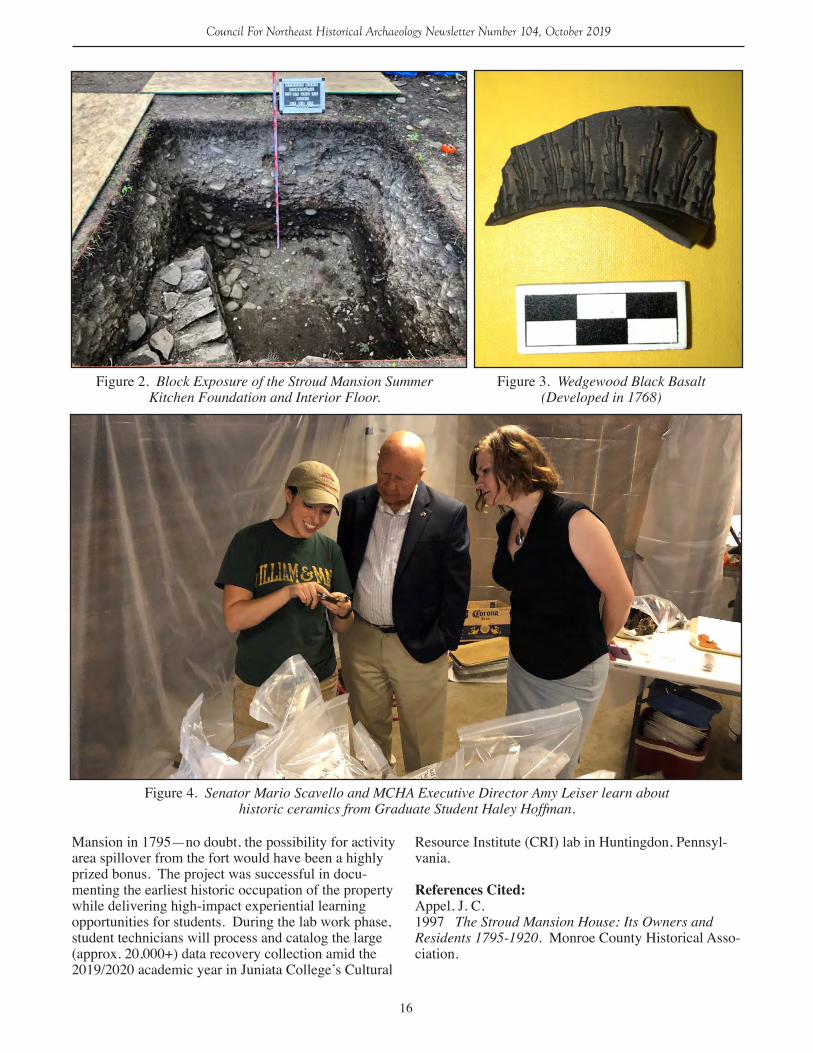
During this summer’s twenty-day field school project, 24 one-meter test units were placed in blocks of four (each 2 x 2 meters) and excavated to sterile outwash cobbles—some to a depth of 2.4 meters below ground surface. Four of the six blocks revealed foundation remnants that likely date to the earliest phase of con-struction on the property—likely the original summer kitchen and barn (Figure 2). Two additional test units explored architectural features adjacent to the founda-tions. Most of the recovered artifacts are early 19th Century ceramics, both English wares like Wedgewood Black Basalt (Figure 3) and domestically produced Philadelphia Slipware. This highly visible archaeolog-ical project received copious attention by the regional media as well as praise from PA State Senator Mario Scavello after a site tour (Figure 4). Several aspects make the project an ideal paring with an archaeological field school, first being the mutually beneficial partnership between MCHA, the PHMC, and Juniata College; second, the complex stratigraphy of the Stroud Mansion property; third, the site’s proximity to Colonial-era Fort Hamilton; and fourth, students are involved in the entire project from fieldwork to cata-loging and research. It was bound to be an excellent educational experience being the building site of Stroud
Figure 1. The 2019 Juniata College Archaeology Field School Crew at Stroud Mansion.
16
Council For Northeast Historical Archaeology Newsletter Number 104, October 2019
Mansion in 1795—no doubt, the possibility for activity area spillover from the fort would have been a highly prized bonus. The project was successful in docu-menting the earliest historic occupation of the property while delivering high-impact experiential learning opportunities for students. During the lab work phase, student technicians will process and catalog the large (approx. 20,000+) data recovery collection amid the 2019/2020 academic year in Juniata College’s Cultural
Resource Institute (CRI) lab in Huntingdon, Pennsyl-vania.
References Cited:Appel, J. C.1997 The Stroud Mansion House: Its Owners and Residents 1795-1920. Monroe County Historical Asso-ciation.
Figure 2. Block Exposure of the Stroud Mansion Summer Kitchen Foundation and Interior Floor.
Figure 3. Wedgewood Black Basalt (Developed in 1768)
Figure 4. Senator Mario Scavello and MCHA Executive Director Amy Leiser learn about historic ceramics from Graduate Student Haley Hoffman.
17
Council For Northeast Historical Archaeology Newsletter Number 104, October 2019
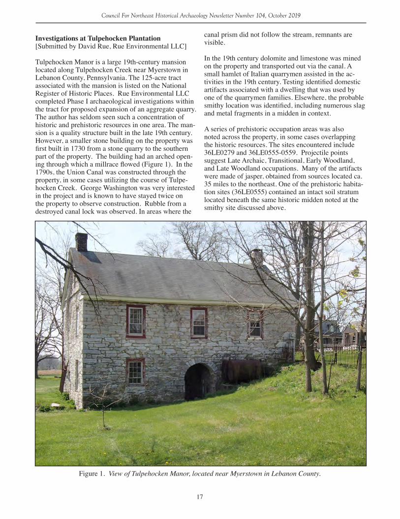
Investigations at Tulpehocken Plantation[Submitted by David Rue, Rue Environmental LLC]
Tulpehocken Manor is a large 19th-century mansion located along Tulpehocken Creek near Myerstown in Lebanon County, Pennsylvania. The 125-acre tract associated with the mansion is listed on the National Register of Historic Places. Rue Environmental LLC completed Phase I archaeological investigations within the tract for proposed expansion of an aggregate quarry. The author has seldom seen such a concentration of historic and prehistoric resources in one area. The man-sion is a quality structure built in the late 19th century. However, a smaller stone building on the property was first built in 1730 from a stone quarry to the southern part of the property. The building had an arched open-ing through which a millrace flowed (Figure 1). In the 1790s, the Union Canal was constructed through the property, in some cases utilizing the course of Tulpe-hocken Creek. George Washington was very interested in the project and is known to have stayed twice on the property to observe construction. Rubble from a destroyed canal lock was observed. In areas where the
canal prism did not follow the stream, remnants are visible.
In the 19th century dolomite and limestone was mined on the property and transported out via the canal. A small hamlet of Italian quarrymen assisted in the ac-tivities in the 19th century. Testing identified domestic artifacts associated with a dwelling that was used by one of the quarrymen families. Elsewhere, the probable smithy location was identified, including numerous slag and metal fragments in a midden in context.
A series of prehistoric occupation areas was also noted across the property, in some cases overlapping the historic resources. The sites encountered include 36LE0279 and 36LE0555-0559. Projectile points suggest Late Archaic, Transitional, Early Woodland, and Late Woodland occupations. Many of the artifacts were made of jasper, obtained from sources located ca. 35 miles to the northeast. One of the prehistoric habita-tion sites (36LE0555) contained an intact soil stratum located beneath the same historic midden noted at the smithy site discussed above.
Figure 1. View of Tulpehocken Manor, located near Myerstown in Lebanon County.
18
Council For Northeast Historical Archaeology Newsletter Number 104, October 2019
2nd Annual PAC Fall Program: “The Challenges of 20th Century Archaeological Resources”[Submitted by Hannah Harvey, Pennsylvania State Historic Preservation Office]
Susquehanna Room, State Museum of Pennsylvania, Harrisburg
Friday, November 8, 2019, 1:30 PM – 4:30 PM The Pennsylvania Archaeological Council’s 2nd An-nual Fall Program will include a series of case studies (listed below) leading into a group discussion about the issues related to the identification, significance, and management of 20th century archaeological resources. A full program and abstracts for this PA SHPO-orga-nized symposium will be sent to members and posted on the website in the near future.
Twentieth Century Archaeological Sites, the Good, the Not so Good, but not the Ugly – Ken Basalik, Ph.D. (CHRS Inc)
“I’ve Been Workin’ on the Railroad” The Archaeology of an Early 20th Century Section House, York County PA – Joe Baker, Genevieve Everett (White Mountain National Forest)
You’re Killing Me Smalls: Defining Three Twenti-eth Century Archaeological Site Types and Research Themes – Scott Shaffer (PennDOT)
Education and Collaboration at Camp Michaux (Michaux State Forest, Cumberland County, Pennsyl-vania) – Maria Bruno (Dickinson College), Joe Baker
Management of Cultural Resources: Case Studies in the Allegheny National Forest – Amanda Rasmussen and Zaakiyah Cua (ANF)
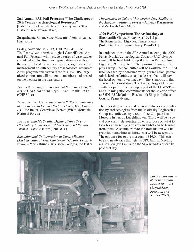
2020 PAC Symposium: The Archaeology of Blacksmith Shops. Friday, April 3, 1-5 pm; The Ramada Inn, Ligonier, Pennsylvania[Submitted by: Susanne Haney, PennDOT]
In conjunction with the SPA Annual meeting, the 2020 Pennsylvania Archaeological Council (PAC) Sympo-sium will be held Friday, April 3, at the Ramada Inn in Ligonier, PA. Prior to the Symposium (noon to 1:00 pm) a wrap luncheon buffet will be available for $17.64 (Includes turkey or chicken wrap, garden salad, potato salad, iced tea/coffee/tea and a dessert. You will pay the hotel on your own that day.) The Symposium this year will be a workshop: The Archaeology of Black-smith Shops. The workshop is part of the FHWA/Pen-nDOT’s mitigation commitments for the adverse effect to 36IN463 McQuilkin Blacksmith Shop in Indiana County, Pennsylvania.
The workshop will consist of an introductory presenta-tion by archaeologists from the Markosky Engineering Group Inc. followed by a tour of the Compass Inn Museum in nearby Laughlintown. There will be a spe-cial blacksmith demonstration with a focus on what to look for at these types of sites and what can be learned from them. A shuttle from/to the Ramada Inn will be provided (donations to defray cost will be accepted). The entrance fee to the museum is $10.00. This can be paid in advance through the SPA Annual Meeting registration (via PayPal on the SPA website) or can be paid that day.
Early 20th-century blacksmith shop in Reynoldston, NY (Reynoldston Research and Studies 2011).
19
Council For Northeast Historical Archaeology Newsletter Number 104, October 2019
MarylandReported by: Silas D. Hurry
St. Mary’s City
Historic St. Mary’s City is pleased to announce the receipt of three awards this year. The first of these was a Maryland Preservation Award from the Maryland Historical Trust for Excellence in Public Program-ing for a special Adults Only Tour. This tour, while informed by archaeology, is primarily based on 17th century historical records which detail the seamy-side of the colonial experience. The tour occurs at the recreated Godiah Spray plantation and features our costumed staff. The second award was given to the Historic St. Mary’s City Foundation and Silas Hurry by the St. Mary’s County Commission for Historic Pres-ervation for the publication of a volume entitled “Our towne we call St. Maries:” Fifty years of Archaeology at Maryland’s First Capital. This small, popular book is lavishly illustrated and surveys a number of the archaeological initiatives undertaken in St. Mary’s City since the museum’s founding in 1967. The final award was from Preservation Maryland for the exhibit The Struggle for Freedom: African American Life in St. Mary’s City in the 19th and 20th Centuries Historic St. Mary’s City. The museum received Community Choice Award for their preservation and education efforts. The new exhibit examines how one building stood as witness to over one hundred years of change, first as a quarter for the enslaved, then after Emancipa-tion as a single family home, and finally as the resi-dence of the Milburn family in the mid-20th century whose memories of living there fill the story with a true human touch.
Crownsville
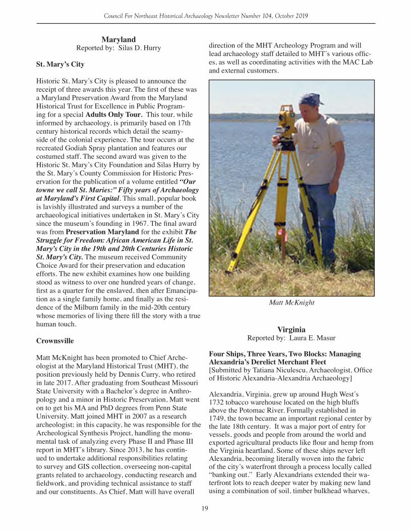
Matt McKnight has been promoted to Chief Arche-ologist at the Maryland Historical Trust (MHT), the position previously held by Dennis Curry, who retired in late 2017. After graduating from Southeast Missouri State University with a Bachelor’s degree in Anthro-pology and a minor in Historic Preservation, Matt went on to get his MA and PhD degrees from Penn State University. Matt joined MHT in 2007 as a research archeologist; in this capacity, he was responsible for the Archeological Synthesis Project, handling the monu-mental task of analyzing every Phase II and Phase III report in MHT’s library. Since 2013, he has contin-ued to undertake additional responsibilities relating to survey and GIS collection, overseeing non-capital grants related to archaeology, conducting research and fieldwork, and providing technical assistance to staff and our constituents. As Chief, Matt will have overall
direction of the MHT Archeology Program and will lead archaeology staff detailed to MHT’s various offic-es, as well as coordinating activities with the MAC Lab and external customers.
Matt McKnight
VirginiaReported by: Laura E. Masur
Four Ships, Three Years, Two Blocks: Managing Alexandria’s Derelict Merchant Fleet[Submitted by Tatiana Niculescu, Archaeologist, Office of Historic Alexandria-Alexandria Archaeology]
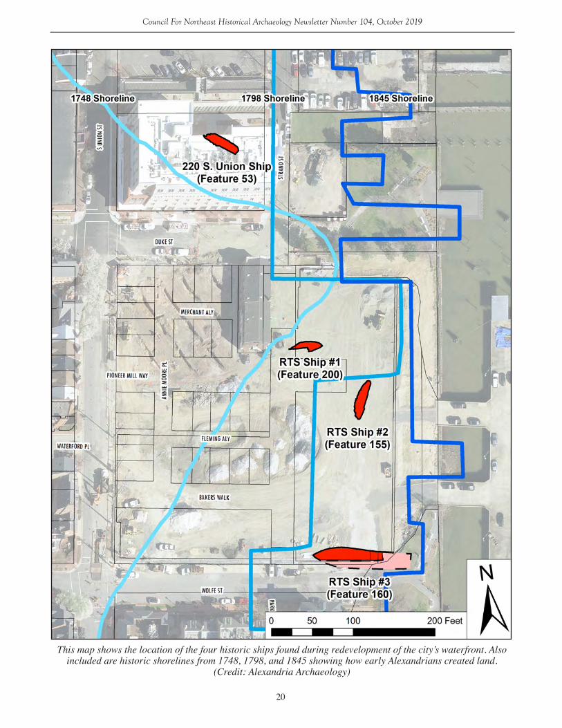
Alexandria, Virginia, grew up around Hugh West’s 1732 tobacco warehouse located on the high bluffs above the Potomac River. Formally established in 1749, the town became an important regional center by the late 18th century. It was a major port of entry for vessels, goods and people from around the world and exported agricultural products like flour and hemp from the Virginia heartland. Some of these ships never left Alexandria, becoming literally woven into the fabric of the city’s waterfront through a process locally called “banking out.” Early Alexandrians extended their wa-terfront lots to reach deeper water by making new land using a combination of soil, timber bulkhead wharves,
20
Council For Northeast Historical Archaeology Newsletter Number 104, October 2019
This map shows the location of the four historic ships found during redevelopment of the city’s waterfront. Also included are historic shorelines from 1748, 1798, and 1845 showing how early Alexandrians created land.
(Credit: Alexandria Archaeology)
21
Council For Northeast Historical Archaeology Newsletter Number 104, October 2019
and occasionally derelict ships. Due to the city’s unique Archaeological Protection Code and recent large-scale development along the waterfront, tangible evidence of this process is coming to light, including four historic ships and numerous wharves and other land-making structures. Documenting, removing, stabilizing, and conserving these artifacts has been a massive under-taking that has required the dedicated efforts of de-velopers, contract archaeology crews, city staff from multiple departments, and a variety of other specialists. Nearly four years after the excavation of the first ship, this piece reflects on both the triumphs and challenges of managing such a large-scale, water-logged collection and outlines our plans and vision for the future.
In December 2015, archaeologists from Thunderbird Archeology unearthed what looked like a possible ship at the Hotel Indigo Site (44AX229). Further explo-ration confirmed that it was indeed a ship (or actually
half a ship). In January 2016 a team of city archaeolo-gists and other staff members, Thunderbird archaeolo-gists, conservators from the Maryland Archaeological Conservation Lab, and the Naval Heritage and History Command excavated the vessel’s remains. The ar-chaeologically-recovered remains, now disarticulated, measured about 46.5 feet long by 12.5 feet wide. The frames (or ribs) of the ship were intentionally sawn along the keel.
Excavating a ship is only the first step in a much larger project. Once excavated, it was transported to and stored at a city facility in tanks of water to prevent further deterioration of the waterlogged wood. In June 2017, a team of city archaeologists and volunteers packed the remains and shipped them to Texas A&M University’s Conservation Research Lab (CRL) for documentation and conservation. The CRL 3D laser scanned each timber and from the half a ship recov-ered, reconstructed the lines of the full vessel. This ship was likely about 70 feet long and had a maximum beam of about 18.5 feet. Its form best matches that of a brig or large sloop, fitting well with the lines of Brig #38 of Plate XXVI in F.H. Chapman’s Architectura Navalis Mercatoria 1768 (Grieco 2019). The relatively flat floors and full hull shape, capable of holding a fair amount of cargo, suggest a merchant vessel. Dendro-chronology samples collected from this vessel indicate that it was constructed with timber felled sometime after 1741 in Massachusetts (Worthington and Seiter 2016: 8). Historic maps suggest that the area where this ship was found was filled in by the 1790s.
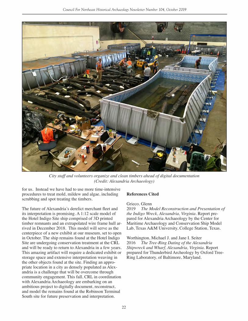
After the excitement surrounding the Hotel Indigo Site ship, it was hard to imagine that there would be anoth-er equally exciting find along the waterfront so soon. However, March 2018 saw the discovery of not one but three more historic ship remnants, uncovered during work at the Robinson Terminal South Site (44AX235). These ship remnants also appear to have been used to make land. Yet again a team of city staff, Thunderbird archaeologists, and the MAC Lab worked to document and excavate these remains.
Like the Hotel Indigo Site ship before it went to Texas, these remains are stored in tanks of water at a city fa-cility. Over 1000 timbers are stored in nine swimming pools and roll off tanks. Since April 2018, city archae-ologists, volunteers, and interns have spent nearly 500 person hours tending to the ongoing preservation needs of these artifacts. Staff change the water in the tanks once a month to keep biological growth like algae and mold at bay. We’ve encountered some unique challeng-es since these ship remains are not slated for immediate conservation. Due to these circumstances, many of the traditional ways conservators abate biological growth on waterlogged wood (i.e., Biocides) are not an option
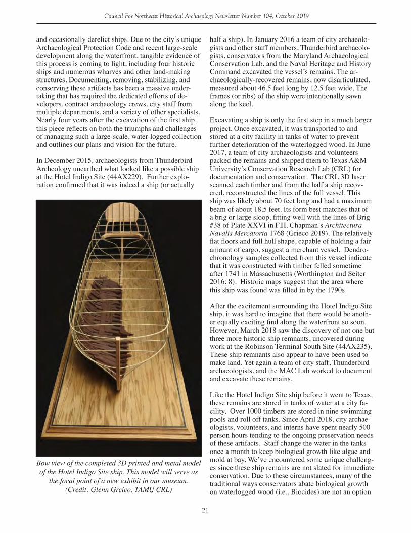
Bow view of the completed 3D printed and metal model of the Hotel Indigo Site ship. This model will serve as
the focal point of a new exhibit in our museum. (Credit: Glenn Greico, TAMU CRL)
22
Council For Northeast Historical Archaeology Newsletter Number 104, October 2019
for us. Instead we have had to use more time-intensive procedures to treat mold, mildew and algae, including scrubbing and spot treating the timbers. The future of Alexandria’s derelict merchant fleet and its interpretation is promising. A 1:12 scale model of the Hotel Indigo Site ship comprised of 3D printed timber remnants and an extrapolated wire frame hull ar-rived in December 2018. This model will serve as the centerpiece of a new exhibit at our museum, set to open in October. The ship remains found at the Hotel Indigo Site are undergoing conservation treatment at the CRL and will be ready to return to Alexandria in a few years. This amazing artifact will require a dedicated exhibit or storage space and extensive interpretation weaving in the other objects found at the site. Finding an appro-priate location in a city as densely populated as Alex-andria is a challenge that will be overcome through community engagement. This fall, CRL in coordination with Alexandria Archaeology are embarking on an ambitious project to digitally document, reconstruct, and model the remains found at the Robinson Terminal South site for future preservation and interpretation.
References Cited
Grieco, Glenn2019 The Model Reconstruction and Presentation of the Indigo Wreck, Alexandria, Virginia. Report pre-pared for Alexandria Archaeology by the Center for Maritime Archaeology and Conservation Ship Model Lab, Texas A&M University, College Station, Texas.
Worthington, Michael J. and Jane I. Seiter2016 The Tree-Ring Dating of the Alexandria Shipwreck and Wharf, Alexandria, Virginia. Report prepared for Thunderbird Archeology by Oxford Tree-Ring Laboratory, of Baltimore, Maryland.
City staff and volunteers organize and clean timbers ahead of digital documentation (Credit: Alexandria Archaeology)

23
Council For Northeast Historical Archaeology Newsletter Number 104, October 2019
Atlantic CanadaReported by: Amanda Crompton
Avertok Archaeology Project, 2018[Submitted by: Lisa K. Rankin, Deirdre Elliott, Laura Kelvin, Maria Lear, and Jacinda Sinclair (Memorial University)]
In 2018, the Avertok Archaeology Project [AAP] continued its investigations into the history and archae-ology of the Inuit community of Hopedale, Labrador. The research was initiated by the Inuit Community Government of Hopedale, Nunatsiavut, in 2017 and it is undertaken with the support of the Tradition and Transition: Piusitukaujuit Asianguvalliajuillu research partnership between Memorial University and the Nun-atsiavut Government. The project encompasses many sub-projects and the research and field work in 2018 had several aims: 1) to develop a community archive of relevant archaeology which can be used by local stake-holders as well as facilitate traditional knowledge trans-fer between youth and Elders in Hopedale, Labrador; 2) to undertake a ground-penetrating radar (GPR) survey of the Moravian Cemetery in Hopedale to identify the locations of all graves, enabling the community to properly mark and care for the cemetery; 3) to locate, excavate, and learn more about the original Inuit settle-ment of Avertok (Agvituk, Arvertok) (GiCb-01) which underlies the present Hopedale community (Figure 1); and 4) investigate other nearby Inuit sites to interpret the settlement of the Hopedale region. The 2018 field
crew included Lisa Rankin (project lead), Deirdre El-liott, Laura Kelvin, Maria Lear, Jacinda Sinclair, Robin Fleming, and Nancy Butler from Memorial University; Graham Hyslop from the University of Western Ontar-io; and Mads Nielsen from the University of Copen-hagen. Hopedale community members working on the team included Denver Edmunds, Nicholas Flowers, Halle Lucy, and John Piercy.
Community Archive and Knowledge TransferLaura Kelvin continued work on her postdoctoral research project, the Avertok Archaeology Digital Archive Project, which aims to develop a community archive of archaeological and traditional knowledge of the Hopedale area. In preparation for the 2018 field season, Kelvin visited the Robert S. Peabody Institute for Archaeology web site, the Rooms Museum and Archives, the American Natural History Museum, the Chicago Field Museum, and the British Museum to photograph and create digital 3D models of artifacts recovered from Avertok and the surrounding area. During the 2018 field season, Kelvin worked with four local youth from Hopedale: Denver Edmunds, Nich-olas Flowers, Halle Lucy, and John Piercy. The youth developed research questions pertaining to some of the artifacts housed in museums and under the guidance of Kelvin, interviewed Elders, community knowledge holders, and archaeologists to learn more about these artifacts and activities associated with them. The team also surveyed nearby archaeological sites where many of the artifacts were originally recovered. To dissemi-
Figure 1. 1934 map of the village of Avertok (by Junius Bird) overlain by contemporary Google Earth image
24
Council For Northeast Historical Archaeology Newsletter Number 104, October 2019
nate their work, they created a series of videos that can be found on the Avertok Archaeology Project’s You-Tube page. The photographs, 3D models of artifacts, interviews, and videos will be part of the community archive.
Community outreach is at the center of the Avertok Archaeology Project. To disseminate AAP research findings to the community, Kelvin maintained the Aver-tok Archaeology Project Facebook page and Instagram account. Social media provided community members with regular updates on our research activities. These accounts will be maintained throughout the winter to update community members on our research. The students also wrote stories about their work for the Tra-dition and Transition website and the December 2018 issue of Them Days Magazine and hosted the Hopedale Literacy Camp for an afternoon to teach them about archaeology. Additionally, at the end of the field season we held a community meeting to meet community members, give presentations about our research, and display some of the artifacts recovered this season.
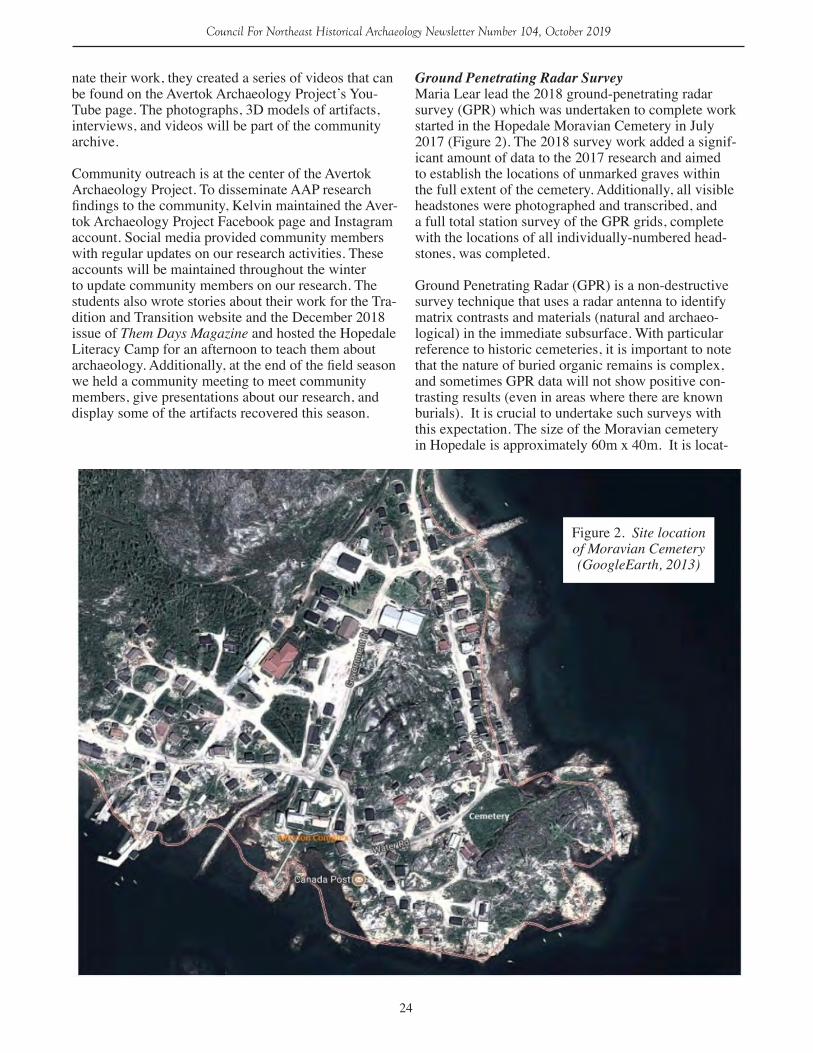
Ground Penetrating Radar SurveyMaria Lear lead the 2018 ground-penetrating radar survey (GPR) which was undertaken to complete work started in the Hopedale Moravian Cemetery in July 2017 (Figure 2). The 2018 survey work added a signif-icant amount of data to the 2017 research and aimed to establish the locations of unmarked graves within the full extent of the cemetery. Additionally, all visible headstones were photographed and transcribed, and a full total station survey of the GPR grids, complete with the locations of all individually-numbered head-stones, was completed.
Ground Penetrating Radar (GPR) is a non-destructive survey technique that uses a radar antenna to identify matrix contrasts and materials (natural and archaeo-logical) in the immediate subsurface. With particular reference to historic cemeteries, it is important to note that the nature of buried organic remains is complex, and sometimes GPR data will not show positive con-trasting results (even in areas where there are known burials). It is crucial to undertake such surveys with this expectation. The size of the Moravian cemetery in Hopedale is approximately 60m x 40m. It is locat-
Figure 2. Site location of Moravian Cemetery (GoogleEarth, 2013)
25
Council For Northeast Historical Archaeology Newsletter Number 104, October 2019
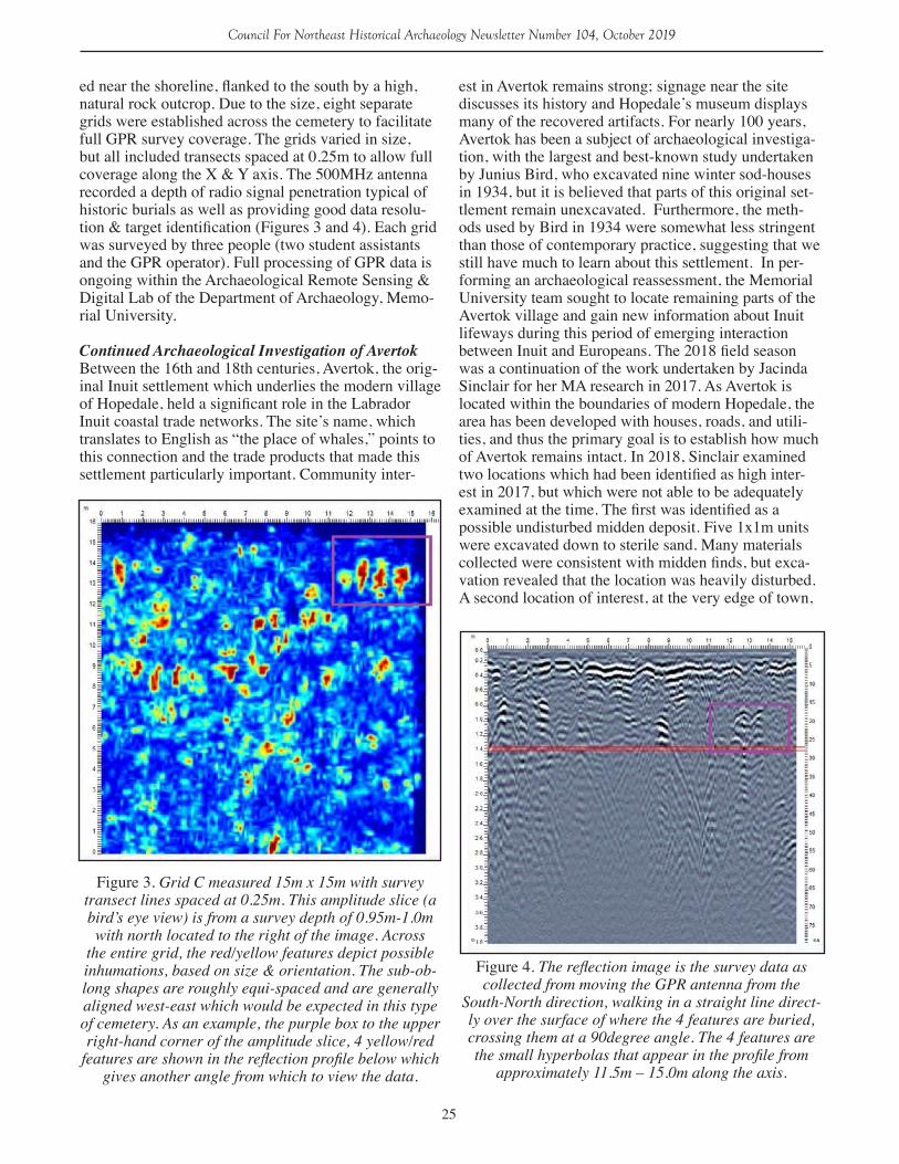
ed near the shoreline, flanked to the south by a high, natural rock outcrop. Due to the size, eight separate grids were established across the cemetery to facilitate full GPR survey coverage. The grids varied in size, but all included transects spaced at 0.25m to allow full coverage along the X & Y axis. The 500MHz antenna recorded a depth of radio signal penetration typical of historic burials as well as providing good data resolu-tion & target identification (Figures 3 and 4). Each grid was surveyed by three people (two student assistants and the GPR operator). Full processing of GPR data is ongoing within the Archaeological Remote Sensing & Digital Lab of the Department of Archaeology, Memo-rial University.
Continued Archaeological Investigation of AvertokBetween the 16th and 18th centuries, Avertok, the orig-inal Inuit settlement which underlies the modern village of Hopedale, held a significant role in the Labrador Inuit coastal trade networks. The site’s name, which translates to English as “the place of whales,” points to this connection and the trade products that made this settlement particularly important. Community inter-
est in Avertok remains strong; signage near the site discusses its history and Hopedale’s museum displays many of the recovered artifacts. For nearly 100 years, Avertok has been a subject of archaeological investiga-tion, with the largest and best-known study undertaken by Junius Bird, who excavated nine winter sod-houses in 1934, but it is believed that parts of this original set-tlement remain unexcavated. Furthermore, the meth-ods used by Bird in 1934 were somewhat less stringent than those of contemporary practice, suggesting that we still have much to learn about this settlement. In per-forming an archaeological reassessment, the Memorial University team sought to locate remaining parts of the Avertok village and gain new information about Inuit lifeways during this period of emerging interaction between Inuit and Europeans. The 2018 field season was a continuation of the work undertaken by Jacinda Sinclair for her MA research in 2017. As Avertok is located within the boundaries of modern Hopedale, the area has been developed with houses, roads, and utili-ties, and thus the primary goal is to establish how much of Avertok remains intact. In 2018, Sinclair examined two locations which had been identified as high inter-est in 2017, but which were not able to be adequately examined at the time. The first was identified as a possible undisturbed midden deposit. Five 1x1m units were excavated down to sterile sand. Many materials collected were consistent with midden finds, but exca-vation revealed that the location was heavily disturbed. A second location of interest, at the very edge of town,
Figure 3. Grid C measured 15m x 15m with survey transect lines spaced at 0.25m. This amplitude slice (a bird’s eye view) is from a survey depth of 0.95m-1.0m with north located to the right of the image. Across
the entire grid, the red/yellow features depict possible inhumations, based on size & orientation. The sub-ob-long shapes are roughly equi-spaced and are generally aligned west-east which would be expected in this type of cemetery. As an example, the purple box to the upper right-hand corner of the amplitude slice, 4 yellow/red
features are shown in the reflection profile below which gives another angle from which to view the data.
Figure 4. The reflection image is the survey data as collected from moving the GPR antenna from the
South-North direction, walking in a straight line direct-ly over the surface of where the 4 features are buried, crossing them at a 90degree angle. The 4 features are the small hyperbolas that appear in the profile from
approximately 11.5m – 15.0m along the axis.
26
Council For Northeast Historical Archaeology Newsletter Number 104, October 2019
was subject to test-pitting. One pit yielded a variety of promising iron and European ceramics, but indicated that this portion of the village had once been heavily impacted by road construction.
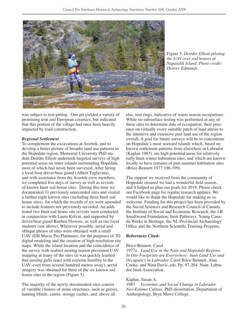
Regional SettlementTo complement the excavations at Avertok, and to develop a better picture of broader land use patterns in the Hopedale region, Memorial University PhD stu-dent Deirdre Elliott undertook targeted surveys of high potential areas on inner islands surrounding Hopedale, most of which had never been surveyed. After hiring a local boat driver/bear guard (Albert Tuglavina), and with assistance from the Avertok crew members, we completed five days of survey as well as revisits of known Inuit sod house sites. During this time we documented 31 previously unrecorded sites and visited a further eight known sites (including three Inuit sod house sites), for which the records of six were amended to include features not previously recorded. An addi-tional two Inuit sod house site revisits were conducted in conjunction with Laura Kelvin, and supported by driver/bear guard Rueben Flowers, as well as our local students (see above). Wherever possible, aerial and oblique photos of sites were obtained with a small UAV (DJI Mavic Pro Platinum), for the purposes of 3D digital modeling and the creation of high-resolution site maps. While the island location and the coincidence of the survey with seabird nesting season prevented UAV mapping at many of the sites (it was quickly learned that nesting gulls react with extreme hostility to the UAV, even from several hundred metres away), aerial imagery was obtained for three of the six known sod house sites in the region (Figure 5).
The majority of the newly-documented sites consist of variable clusters of stone structures, such as graves, hunting blinds, cairns, storage caches, and, above all
else, tent rings, indicative of warm season occupations. While no subsurface testing was performed at any of these sites to determine date of occupation, their pres-ence on virtually every suitable patch of land attests to the intensive and extensive past land use of the region overall. A goal for future surveys will be to concentrate on Hopedale’s most seaward islands which, based on known settlement patterns from elsewhere in Labrador (Kaplan 1983), are high potential areas for relatively early Inuit winter habitation sites, and which are known locally to have remains of past summer habitation sites (Brice-Bennett 1977:196-199).
The support we received from the community of Hopedale ensured we had a wonderful field season, and it helped us plan our goals for 2019. Please check our Facebook page for regular research updates. We would like to thank the Hopedale for making us so welcome. Funding for this project has been provided by the Social Sciences and Research Council of Canada, the Institute of Social and Economic Research, the J.R Smallwood Foundation, Inuit Pathways, Young Cana-da Works in Heritage, the NL Provincial Archaeology Office and the Northern Scientific Training Program.
References Cited:
Brice-Bennett, Carol1977a Land Use in the Nain and Hopedale Regions. In Our Footprints are Everywhere: Inuit Land Use and Occupancy in Labrador. Carol Brice-Bennett, Alan Cooke, and Nina Davis, eds. Pp. 97-204. Nain: Labra-dor Inuit Association.
Kaplan, Susan A.1983 Economic and Social Change in Labrador Neo-Eskimo Culture. PhD dissertation, Department of Anthropology, Bryn Mawr College.
Figure 5. Deirdre Elliott piloting the UAV over sod houses at Napatalik Island. Photo credit: Denver Edmunds.
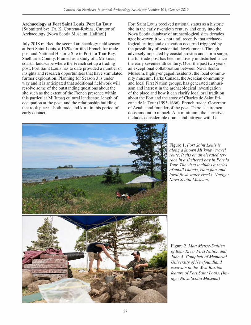
27
Council For Northeast Historical Archaeology Newsletter Number 104, October 2019
Archaeology at Fort Saint Louis, Port La Tour [Submitted by: Dr. K. Cottreau-Robins, Curator of Archaeology (Nova Scotia Museum, Halifax)]
July 2018 marked the second archaeology field season at Fort Saint Louis, a 1620s fortified French fur trade post and National Historic Site in Port La Tour Bay, Shelburne County. Framed as a study of a Mi’kmaq coastal landscape where the French set up a trading post, Fort Saint Louis has to date provided a number of insights and research opportunities that have stimulated further exploration. Planning for Season 3 is under way and it is anticipated that additional fieldwork will resolve some of the outstanding questions about the site such as the extent of the French presence within this particular Mi’kmaq cultural landscape, length of occupation at the post, and the relationship building that took place – both trade and kin - in this period of early contact.
Fort Saint Louis received national status as a historic site in the early twentieth century and entry into the Nova Scotia database of archaeological sites decades ago; however, it was not until recently that archaeo-logical testing and excavation occurred triggered by the possibility of residential development. Though adversely impacted by coastal erosion and storm surge, the fur trade post has been relatively undisturbed since the early seventeenth century. Over the past two years an exceptional collaboration between Nova Scotia Museum, highly-engaged residents, the local commu-nity museum, Parks Canada, the Acadian community and local First Nation groups, has generated enthusi-asm and interest in the archaeological investigation of the place and how it can clarify local oral tradition about the Fort and the story of Charles de Saint Eti-enne de la Tour (1593-1666), French trader, Governor of Acadia and founder of the post. There is a tremen-dous amount to unpack. At a minimum, the narrative includes considerable drama and intrigue with La
Figure 2. Matt Meuse-Dallien of Bear River First Nation and John A. Campbell of Memorial University of Newfoundland excavate in the West Bastion feature of Fort Saint Louis. (Im-age: Nova Scotia Museum)
Figure 1. Fort Saint Louis is along a known Mi’kmaw travel route. It sits on an elevated ter-race in a sheltered bay in Port la Tour. The vista includes a series of small islands, clam flats and local fresh water creeks. (Image: Nova Scotia Museum)
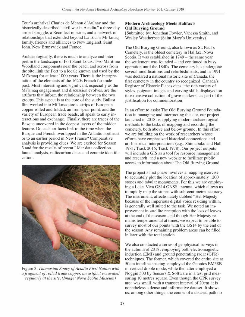
28
Council For Northeast Historical Archaeology Newsletter Number 104, October 2019
Tour’s archrival Charles de Menou d’Aulnay and the historically described “civil war in Acadia,” a three-day armed struggle, a Recollect mission, and a network of relationships that extended beyond La Tour’s Mi’kmaq family, friends and alliances to New England, Saint John, New Brunswick and France. Archaeologically, there is much to analyze and inter-pret in the landscape of Fort Saint Louis. Two Maritime Woodland components near the beach and across from the site, link the Fort to a locale known and used by the Mi’kmaq for at least 1000 years. There is the interpre-tation of the elements of the 1620s French fur trade post. Most interesting and significant, especially as the Mi’kmaq engagement and discussion evolves, are the artifacts that inform the relationship between the two groups. This aspect is at the core of the study. Ballast flint worked into Mi’kmaq tools, strips of European copper rolled and folded, an iron spear point, and the variety of European trade beads, all speak to early in-teractions and exchange. Finally, there are traces of the Basque uncovered in the deepest layers of the midden feature. Do such artifacts link to the time when the Basque and French overlapped in the Atlantic northeast or to an earlier period in New France? Comparative analysis is providing clues. We are excited for Season 3 and for the results of recent Lidar data collection, faunal analysis, radiocarbon dates and ceramic identifi-cation.
Figure 3. Thomasina Soucy of Acadia First Nation with a fragment of rolled trade copper, an artifact excavated
regularly at the site. (Image: Nova Scotia Museum)
Modern Archaeology Meets Halifax’s Old Burying Ground[Submitted by: Jonathan Fowler, Vanessa Smith, and Wesley Weatherbee (Saint Mary’s University)]
The Old Burying Ground, also known as St. Paul’s Cemetery, is the oldest cemetery in Halifax, Nova Scotia. It was established in 1749 – the same year the settlement was founded – and continued in busy operation until the 1840s. The cemetery has undergone several modifications and refurbishments, and in 1991 was declared a national historic site of Canada, the first cemetery in the country so recognized. Canada’s Register of Historic Places cites “the rich variety of styles, poignant images and carving skills displayed on its extensive collection of grave markers” as part of the justification for commemoration.
In an effort to assist The Old Burying Ground Founda-tion in managing and interpreting the site, our project, launched in 2018, is applying modern archaeological methods to the tasks of mapping and recording the cemetery, both above and below ground. In this effort we are building on the work of researchers whose efforts have emphasized historical connections and art-historical interpretations (e.g., Shimabuku and Hall 1981; Trask 2015; Trask 1978). Our project outputs will include a GIS as a tool for resource management and research, and a new website to facilitate public access to information about The Old Burying Ground.
The project’s first phase involves a mapping exercise to accurately plot the location of approximately 1200 stones and tabular monuments. For this we are employ-ing a Leica Viva GS14 GNSS antenna, which allows us to rapidly map the stones with sub-centimetre accuracy. The instrument, affectionately dubbed “Her Majesty” because of the imperious digital voice residing within, is generally well suited to the task. We noted an im-provement in satellite reception with the loss of leaves at the end of the season, and though Her Majesty re-mains temperamental at times, we expect to be able to survey most of our points with the GS14 by the end of the season. Any remaining problem areas can be filled in later with the total station.
We also conducted a series of geophysical surveys in the autumn of 2018, employing both electromagnetic induction (EMI) and ground penetrating radar (GPR) techniques. The former, which covered the entire site at 50cm interline spacing, employed the Geonics EM38B in vertical dipole mode, while the latter employed a Noggin 500 by Sensors & Software in a test grid mea-suring 10 metres square. Even though the GPR survey area was small, with a transect interval of 20cm, it is nonetheless a dense and informative dataset. It shows us, among other things, the course of a disused path no
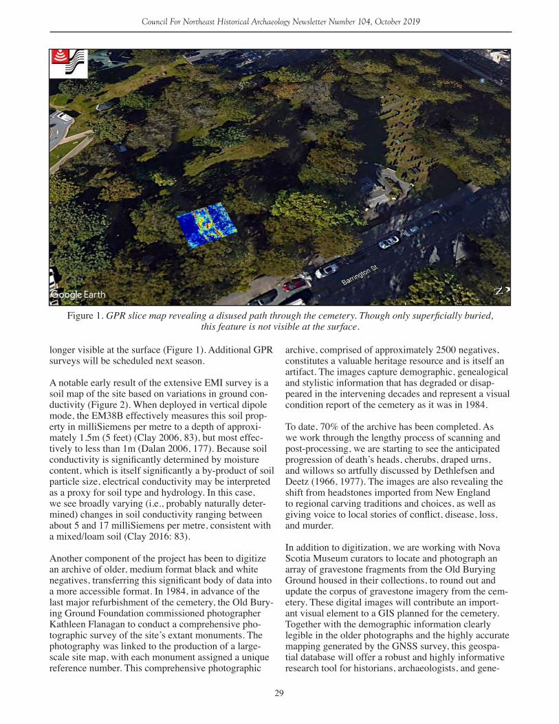
29
Council For Northeast Historical Archaeology Newsletter Number 104, October 2019
longer visible at the surface (Figure 1). Additional GPR surveys will be scheduled next season.
A notable early result of the extensive EMI survey is a soil map of the site based on variations in ground con-ductivity (Figure 2). When deployed in vertical dipole mode, the EM38B effectively measures this soil prop-erty in milliSiemens per metre to a depth of approxi-mately 1.5m (5 feet) (Clay 2006, 83), but most effec-tively to less than 1m (Dalan 2006, 177). Because soil conductivity is significantly determined by moisture content, which is itself significantly a by-product of soil particle size, electrical conductivity may be interpreted as a proxy for soil type and hydrology. In this case, we see broadly varying (i.e., probably naturally deter-mined) changes in soil conductivity ranging between about 5 and 17 milliSiemens per metre, consistent with a mixed/loam soil (Clay 2016: 83).
Another component of the project has been to digitize an archive of older, medium format black and white negatives, transferring this significant body of data into a more accessible format. In 1984, in advance of the last major refurbishment of the cemetery, the Old Bury-ing Ground Foundation commissioned photographer Kathleen Flanagan to conduct a comprehensive pho-tographic survey of the site’s extant monuments. The photography was linked to the production of a large-scale site map, with each monument assigned a unique reference number. This comprehensive photographic
archive, comprised of approximately 2500 negatives, constitutes a valuable heritage resource and is itself an artifact. The images capture demographic, genealogical and stylistic information that has degraded or disap-peared in the intervening decades and represent a visual condition report of the cemetery as it was in 1984.
To date, 70% of the archive has been completed. As we work through the lengthy process of scanning and post-processing, we are starting to see the anticipated progression of death’s heads, cherubs, draped urns, and willows so artfully discussed by Dethlefsen and Deetz (1966, 1977). The images are also revealing the shift from headstones imported from New England to regional carving traditions and choices, as well as giving voice to local stories of conflict, disease, loss, and murder.
In addition to digitization, we are working with Nova Scotia Museum curators to locate and photograph an array of gravestone fragments from the Old Burying Ground housed in their collections, to round out and update the corpus of gravestone imagery from the cem-etery. These digital images will contribute an import-ant visual element to a GIS planned for the cemetery. Together with the demographic information clearly legible in the older photographs and the highly accurate mapping generated by the GNSS survey, this geospa-tial database will offer a robust and highly informative research tool for historians, archaeologists, and gene-
Figure 1. GPR slice map revealing a disused path through the cemetery. Though only superficially buried, this feature is not visible at the surface.

30
Council For Northeast Historical Archaeology Newsletter Number 104, October 2019
alogists seeking to better understand the Old Burying Ground and its residents.
Taking this work one step further, we are employing digital photogrammetry as a means of rendering 3D models of the stones for analysis and interpretation using the structure from motion software, Agisoft Photoscan. Structure from motion software is rapidly becoming a part of the modern archaeological toolkit for documenting, mapping, analyzing, and presenting heritage resources (Chibunichev et al. 2018; Howland et al. 2014). The Old Burying Ground is well-suited to the application of digital photogrammetry to produce a versatile digital record of heritage monuments in their current state of preservation.
Photography collection methodologies for documenting stones vary with the level of detail required. 3D models intended for presentation are produced using relatively small numbers of digital photographs taken in sequence in 360 degrees around the monument. A model of the headstone of John and Jane Conway uses only 27 pho-tographs captured with a Samsung Galaxy Note 9 and was processed in only 5 minutes and 31 seconds using low-quality settings at sparse and dense point cloud
generation, mesh generation, and texture mapping stag-es (Figure 3). The number of photographs needed to obtain the degree of overlap required for this 3D model was low because the monument fits within the frame of the photographs.
Producing 3D models for detailed analysis requires more photographs, as do cases with heavily weathered epigraphy, which necessitate capturing photographs closer to the monument. French researchers have recently investigated the application of digital photo-grammetry to visualize highly weathered epigraphy with promising results (Samaan et al. 2016). To refine our methodology for recording subtle epigraphic de-tails, DSLR cameras will be used to capture the photo-graphs, and the camera will be calibrated using Agi-soft Lens. The large file sizes and high-end hardware necessary to visualize the higher resolution 3D models make these products less accessible overall, and there-fore justifies the expedient production of lower quality models for general documentation and presentation. Our future endeavours will employ this methodology in hopes of recovering lost inscriptions at the site. By bringing some of archaeology’s modern toolkit to the site, we hope this multi-year project will not only assist
Figure 2. Soil conductivity map showing natural soil changes in the cemetery. Localized spikes in the data are mostly attributable to the iron fence bordering the property, iron elements in some of the monuments,
and lead flashing used to conserve several of the stones.
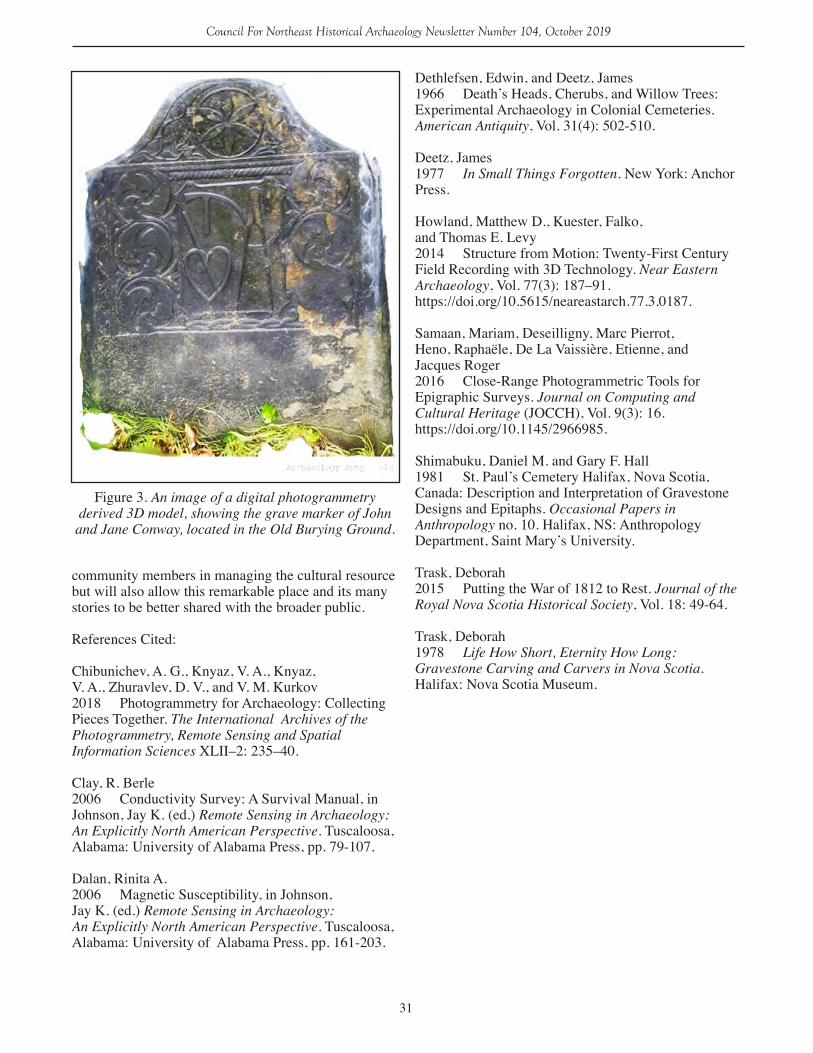
31
Council For Northeast Historical Archaeology Newsletter Number 104, October 2019
community members in managing the cultural resource but will also allow this remarkable place and its many stories to be better shared with the broader public.
References Cited:
Chibunichev, A. G., Knyaz, V. A., Knyaz, V. A., Zhuravlev, D. V., and V. M. Kurkov 2018 Photogrammetry for Archaeology: Collecting Pieces Together. The International Archives of the Photogrammetry, Remote Sensing and SpatialInformation Sciences XLII–2: 235–40.
Clay, R. Berle 2006 Conductivity Survey: A Survival Manual, in Johnson, Jay K. (ed.) Remote Sensing in Archaeology: An Explicitly North American Perspective. Tuscaloosa, Alabama: University of Alabama Press, pp. 79-107.
Dalan, Rinita A. 2006 Magnetic Susceptibility, in Johnson, Jay K. (ed.) Remote Sensing in Archaeology: An Explicitly North American Perspective. Tuscaloosa, Alabama: University of Alabama Press, pp. 161-203.
Dethlefsen, Edwin, and Deetz, James 1966 Death’s Heads, Cherubs, and Willow Trees: Experimental Archaeology in Colonial Cemeteries. American Antiquity, Vol. 31(4): 502-510.
Deetz, James 1977 In Small Things Forgotten. New York: Anchor Press.
Howland, Matthew D., Kuester, Falko, and Thomas E. Levy 2014 Structure from Motion: Twenty-First Century Field Recording with 3D Technology. Near Eastern Archaeology, Vol. 77(3): 187–91. https://doi.org/10.5615/neareastarch.77.3.0187.
Samaan, Mariam, Deseilligny, Marc Pierrot, Heno, Raphaële, De La Vaissière, Etienne, and Jacques Roger 2016 Close-Range Photogrammetric Tools for Epigraphic Surveys. Journal on Computing and Cultural Heritage (JOCCH), Vol. 9(3): 16. https://doi.org/10.1145/2966985.
Shimabuku, Daniel M. and Gary F. Hall 1981 St. Paul’s Cemetery Halifax, Nova Scotia, Canada: Description and Interpretation of Gravestone Designs and Epitaphs. Occasional Papers in Anthropology no. 10. Halifax, NS: Anthropology Department, Saint Mary’s University.
Trask, Deborah 2015 Putting the War of 1812 to Rest. Journal of the Royal Nova Scotia Historical Society, Vol. 18: 49-64.
Trask, Deborah 1978 Life How Short, Eternity How Long: Gravestone Carving and Carvers in Nova Scotia. Halifax: Nova Scotia Museum.
Figure 3. An image of a digital photogrammetry derived 3D model, showing the grave marker of John and Jane Conway, located in the Old Burying Ground.
32
Council For Northeast Historical Archaeology Newsletter Number 104, October 2019
Membership Fees
Membership Type / Type d’adhésion $US $CDN ____ Individual / ordinaire $40.00 40.00 ____ Student (1) / étudiant (1) $25.00 25.00 ____ Retired / retraité $35.00 35.00 ____ Joint (2) / conjoint (2) $45.00 45.00 ____ Fellow (3) / associé (3) $55.00 55.00 ____ Life / à vie $600.00 600.00 ____ Business / entreprise - $55.00 55.00 Institution /Institution (1) Must send copy of current student I.D. Veuillez inclure une preuve de statut d’étudiant pour l’année courante. (2) For two people at the same mailing address receiving only one copy of publications. Pour deux personnes résidant à la même adresse postale – elles ne reçoivent qu’un seul exemplaire des publications. (3) For those who feel a primary commitment to Northeast Historical Archaeology and wish to support the work of the Council at a higher membership rate. Pour les personnes qui s’intéressent hautement à l’archéologie historique du Nord-Est amèricain et qui veulent aider à soutenir l’action du Conseil en versant une cotisation plus élevée.
Name / Nom: __________________________________________________________________________ Address / Adresse: _____________________________________________________________________ _____________________________________________________________________________________ _____________________________________________________________________________________ Telephone / Téléphone : ________________________ E-Mail / Courriel : __________________________ Permission to publish E-Mail address in Newsletter/ Permission de publier l’adresse électronique en Bulletin:
Yes / Oui o No / Non o
YOU MUST INCLUDE YOUR EMAIL SINCE WE HAVE MOVED TO AN ELECTRONIC ONLY VERSION OF THE NEWSLETTER! (see below)
Make checks payable to CNEHA. / Établir les chèques à l’ordre du CNEHA. The last printed edition of the Newsletter was October 2015 Newsletter (No. 92). In an effort to maintain current mem-bership rates, the Board has voted to transition all subsequent newsletters to an electronic format that will be sent to all members via email. Le bulletin (no. 92), celui du mois d’octobre dernier, aura été le dernier numéro imprimé. Afin de maintenir les taux d’abonnements actuels, l’exécutif a voté en faveur d’un format électronique pour les bulletins. Tous les bulletins seront donc envoyés aux membres par courriel à l’avenir.
Mail Application To
Canada Joseph Last P.O. Box 1961 Cornwall, Ontario Canada K6H 6N7
USA and International Sara Mascia 16 Colby Lane Briarcliff Manor, NY, USA 10510