Embed Size (px)
Citation preview
u.8 ~04 • Oeo:zo
5$. Cuat ~.t ca:z Copv is PUS! 1c po 'J'"=RTY . 5 Bat 0111 ]f. Sn-... .
to be remcv·;d· f; c~·~ --;h~ offi~:1 /i~e~Ot I .J) D A_ R·· ' J!y-.·
8
4lll c(ip:Co~yt~c.:::Zt.t~-0-.l'llv:e;!a. PRIVATE ross~ss:cN 1s UNLAWFUL uai\61 't' ., ... (R. S. S4P. Vol. 2 _p_p. 360"* .Sec:. .7~
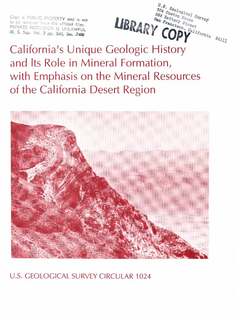
California 1s Unique Geologic History and Its Role in Mineral Formation, with Emphasis on the Mineral Resources of the California Desert Region
U.S. GEOLOGICAL SURVEY CIRCULAR 1024
AVAILABILITY OF BOOKS AND MAPS OF THE U.S. GEOLOGICAL SURVEY
Instructions on ordering publications of the U.S. Geological Survey, along with prices of the last offerings, are given in the current-year issues of the monthly catalog "New Publications of the U.S. Geological Survey." Prices of available U.S. Geological Survey publications released prior to the current year are listed in the most recent annual "Price and Availability List." Publications that are listed in various U.S. Geological Survey catalogs (see back inside cover) but not listed in the most recent annual "Price and Availability List" are no longer available.
Prices of reports released to the open files are given in the listing "U.S. Geological Survey Open-File Reports," updated monthly, which is for sale in microfiche from the U.S. Geological Survey, Books and Open-File Reports Section, Federal Center, Box 25425, Denver, CO 80225. Reports released through the NTIS may be obtained by writing to the National Technical Information Service, U.S. Department of Commerce, Springfield, VA 22161; please include NTIS report number with inquiry.
Order U.S. Geological Survey publications by mail or over the counter from the offices given below.
BY MAIL
Books
Professional Papers, Bulletins, Water-Supply Papers, Techniques of Water-Resources Investigations, Circulars, publications of general interest (such as leaflets, pamphlets, booklets), single copies of Earthquakes & Volcanoes, Preliminary Determination of Epicenters, and some miscellaneous reports, including some of the foregoing series that have gone out of print at the Superintendent of Documents, are obtainable by mail from
U.S. Geological Survey, Books and Open-File Reports Federal Center, Box 25425
Denver, CO 80225
Subscriptions to periodicals (Earthquakes & Volcanoes and Preliminary Determination of Epicenters) can be obtained ONLY from the
Superintendent of Documents Government Printing Office
Washington, D.C. 20402
(Check or money order must be payable to Superintendent of Documents.)
Maps
For maps, address mail orders to
U.S. Geological Survey, Map Distribution Federal Center, Box 25286
Denver, CO 80225
Residents of Alaska may order maps from
Alaska Distribution Section, U.S. Geological Survey, New Federal Building - Box 12
101 Twelfth Ave., Fairbanks, AK 99701
OVER THE COUNTER
Books
Books of the U.S. Geological Survey are available over the counter at the following Geological Survey Public Inquiries Offices, all of which are authorized agents of the Superintendent of Documents:
• WASHINGTON, D.C.--Main Interior Bldg., 2600 corridor, 18th and C Sts., NW.
• DENVER, Colorado--Federal Bldg., Rm. 169, 1961 Stout St.
• LOS ANGELES, California--Federal Bldg., Rm. 7638, 300 N. Los Angeles St.
• MENLO PARK, California--Bldg. 3 (Stop 533), Rm. 3128, 345 Middlefield Rd.
• RESTON, Virginia--503 National Center, Rm. 1C402, 12201 Sunrise Valley Dr.
• SALT LAKE CITY, Utah--Federa1Bldg., Rm. 8105, 125 South State St.
• SAN FRANCISCO, California--Customhouse, Rm. 504, 555 Battery St.
• SPOKANE, Washington--U.S. Courthouse, Rm. 678, West 920 Riverside Ave ..
• ANCHORAGE, Alaska--Rm. 101, 4230 University Dr. • ANCHORAGE, Alaska--Federal Bldg, Rm. E-146, 701 C St.
Maps
Maps may be purchased over the counter at the U.S. Geological Survey offices where books are sold (all addresses in above list) and at the following Geological Survey offices:
• ROLLA, Missouri--1400 Independence Rd. • DENVER, Colorado--Map Distribution, Bldg. 810, Federal
Center • FAIRBANKS, Alaska--New Federal Bldg., 101 Twelfth Ave.
California•s Unique Geologic History and Its Role in Mineral Formation, with Emphasis on the Mineral Resources of the California Desert Region
By DAVID A. DELLINGER
U.S. GEOLOGICAL SURVEY CIRCULAR 1024

DEPARTMENT OF THE INTERIOR
DONALD PAUL HODEL, Secretary
U.S. GEOLOGICAL SURVEY
Dallas L. Peck, Director
Any use of trade, product, industry, or firm names in this publication is for descriptive purposes only and does not imply endorsement by the U.S. Government
UNITED STATES GOVERNMENT PRINTING OFFICE, WASHINGTON : 1989
For sale by the Books and Open-File Reports Section U.S. Geological Survey Federal Center, Box 25425 Denver, CO 80225
Library of Congress Cataloging-in-Publication Data
Dellinger, D.A. California's unique geologic history and its role in
mineral formation, with emphasis on the mineral resources of the California desert region.
(U.S. Geological Survey circular; 1024) Bibliography: p. Supt. of Docs. no.: I 19.4/2:1024 1. Mines and mineral resources-California. 2.
Geology-California. 3. Deserts-California. I. Title. II. Series.
TN24.C2D45 1989 553'.09794 88-607955
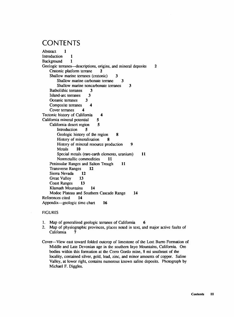
CONTENTS Abstract 1 Introduction 1 Background 1 Geologic terranes-descriptions, origins, and mineral deposits 2
Cratonic platform terrane 2 Shallow marine terranes (cratonic) 3
Shallow marine carbonate terrane 3 Shallow marine noncarbonate terranes 3
Batholithic terranes 3 Island-arc terranes 3 Oceanic terranes 3 Composite terranes 4 Cover terranes 4
Tectonic history of California 4 California mineral potential 5
California desert region 5 Introduction 5 Geologic history of the region 8 History of mineralization 8 History of mineral resource production 9 Metals 10 Special metals (rare-earth elements, uranium) 11 Nonmetallic commodities 11
Peninsular Ranges and Salton Trough 11 Transverse Ranges 12 Sierra Nevada 12 Great Valley 13 Coast Ranges 13 Klamath Mountains 14 Modoc Plateau and Southern Cascade Range 14
References cited 14 Appendix-geologic time chart 16
FIGURES
1. Map of generalized geologic terranes of California 6 2. Map of physiographic provinces, places noted in text, and major active faults of
California 7
Cover-View east toward folded outcrop of limestone of the Lost Burro Formation of Middle and Late Devonian age in the southern Inyo Mountains, California. Ore bodies within this formation at the Cerro Gordo mine, 8 mi southeast of the locality, contained silver, gold, lead, zinc, and minor amounts of copper. Saline Valley, at lower right, contains numerous known saline deposits. Photograph by Michael F. Diggles.
Contents Ill

California's Unique Geologic History and Its Role 1n Mineral Formation, with Emphasis on the Mineral Resources of the California Desert Region By David A. Dellinger
Abstract
California's mineral wealth results from its long, complex, and active geologic history. The diversity of rock types in the State and the variety of geologic processes that have acted on these rocks have led to the formation of an unusual diversity of mineral deposits and the creation of some large and very unusual deposits.
Two uncommon geologic events that have occurred in the geologic history of southeastern California have endowed the desert region with very large deposits of two unusual types of mineral deposits. The intrusion of a rare type of igneous rock about 1.4 billion years ago created the largest rare-earth-element deposit in the United States. Much more recently, during the past 20 million years or so, an unusual combination of geologic and climatic conditions has led to the formation of very large borate deposits. Nearly half of the world's present production of borate minerals comes from these desert deposits.
The occurrence of mineral resources in any area is related to the geologic history of the area; the geologic processes that form and subsequently modify the rocks of an area are also responsible for the creation of any mineral deposits found there. California can be divided into eight types of geologic terranes, each of which formed under a certain general set of conditions; each type of terrane thus contains a set of characteristic rock assemblages and mineral deposit types related to its particular geologic history.
The geologic history of California extends over approximately 1.7 billion years, during which the area has been progressively enlarged to the west by the attachment of terranes, some of which were created elsewhere and carried toward the continent (craton) by the motion of tectonic plates. Some of the processes that led to the formation of mineral deposits in California were active before the attachment of these terranes to the craton, whereas others occurred during or after terrane attachment. For example, some types of mineral deposits that occur in California are created only at ocean-floor hot springs; these deposits are found only in oceanic terranes that have become part of the State.
Manuscript approved for publication, November 15, 1988.
This report briefly describes California's geologic terranes, the origins of those terranes, and the types of mineral deposits typically associated with each terrane. The mineral potential of each of the State's physiographic provinces is summarized.
INTRODUCTION
The Federal Land Policy and Management Act of 1976 (Public Law 94-579) requires the Bureau of Land Management (BLM) to inventory and identify the resource and other values of lands under their jurisdiction in the State of California and to report the results of these studies to the public, the President, and the Congress. The law also requires the U.S. Geological Survey and the U.S. Bureau of Mines to conduct mineral resource surveys on certain of these lands; the results of these surveys have been presented in numerous reports that give specific assessments of the identified mineral resources and of the potential for undiscovered mineral resources for individual areas. This report, in contrast, presents a broader, region-by-region summary of the geology, geologic history, identified mineral resources, and mineral resource potential of the State of California, with emphasis on the California desert region, to help integrate the assessments of mineral potential in individual areas. Special treatment is given to the California desert region because of major land-use issues regarding the BLM's California Desert Conservation Area, which occupies much of the desert region.
BACKGROUND
The regional mineral resource assessments presented in this report are taken mostly from earlier compilations by Albers (1981) and Albers and Fraticelli (1984). Their assessments were based on the premise that individual geologic terranes tend to be characterized by particular
Background
mineral deposit types; they divided the State into eight types of geologic terranes, each of which contains a characteristic set of deposit types.
The term "geologic terrane," as used here, refers to a discrete portion of the Earth's crust that was created in a specific plate-tectonic setting; in some cases, these terranes formed far from the place where the terrane is now exposed. Each type of geologic terrane is composed of a particular assemblage of rock types; the assemblage found in a given terrane reflects the geologic processes characteristic of the plate-tectonic environment or setting in which it formed. Similarly, the formation of mineral deposits in these rock assemblages results from the action of specific geologic processes associated with particular plate-tectonic settings. Thus, each type of geologic terrane has a unique set of rock types and associated mineral deposit types that reflect the geologic processes characteristic of a particular plate tectonic setting. Specific geologic terrane types and their associated suites of mineral deposits are described below.
Three important conditions complicate the relatively simple portrait of the relations between terranes and mineral deposits presented above. ( 1) Individual geologic terranes are usually composed of several or many different rock types; however, many types of mineral deposits are restricted to particular types of rock, so potential for these mineral deposits is restricted to those parts of a terrane where the appropriate rock type is present. For example, the oceanic terrane that makes up much of California's northern Coast Ranges is composed of numerous rock types, only a fraction of which are ultramafic. Chromite deposits are nearly always found in association with ultramafic rocks, so only those areas in the Coast Ranges that contain exposures of ultramafic rock are considered permissive for the occurrence of undiscovered chromite. (2) Although geologic terranes are defined on the basis of the plate-tectonic environment in which they formed, their subsequent history usually reflects a wide variety of events and processes related to other tectonic regimes. For example, one type of geologic terrane considered in this report is shallow marine carbonate terrane, which formed along what was the western edge of the North American continent (craton) during late Precambrian and Paleozoic time (see Appendix-geologic time chart). During the Mesozoic and early Cenozoic eras, parts of this terrane were intruded by magma generated in and above a slab of oceanic crust as it slid (was subducted) beneath the continent. As a result, the carbonate terrane now includes isolated plutons and dikes that crystallized from this magma, and parts of it are covered by volcanic rocks. The terrane was cut by both high- and low-angle faults during the same period. Mineralization within the carbonate terrane was restricted almost entirely to areas subjected to post-Paleozoic magmatism or faulting-processes associated with tectonic events that occurred long after the terrane had been
formed. (3) In many areas, California's geologic terranes are overlain by sedimentary or volcanic material that was deposited during the latest Mesozoic and Cenozoic eras, after the older geologic terranes were assembled into their present configuration by the joining (accretion) of exotic terranes to the craton. These sedimentary and volcanic materials may be largely or entirely independent of the terranes over which they lie, and they should be considered as a separate type of terrane superimposed on the others. Cover terrane, like other terrane types, has a characteristic set of mineral deposits. At present, the most valuable of these are the oil and gas deposits contained within some of these cover rocks and sediments.
In this report, deposits of the metallic commodities are given the most thorough consideration. Occurrences of, and areas permissive for, oil and gas deposits and geothermal energy resources are mentioned briefly if they occur in the province under discussion. Consideration of industrial materials (sand and gravel, aggregate, building stone, and specialized deposits like zeolites, gypsum, and perlite) and other nonmetallic deposits (evaporite or saline deposits, for example) is generally restricted to discussions of resources in the California desert region.
Estimates of mineral resource potential noted in this report are based largely on the compilations of Albers (1981) and Albers and Fraticelli (1984); numerous other published sources have also been used, especially for resource data on the California desert region.
GEOLOGIC TERRANES-DESCRIPTIONS, ORIGINS, AND MINERAL DEPOSITS
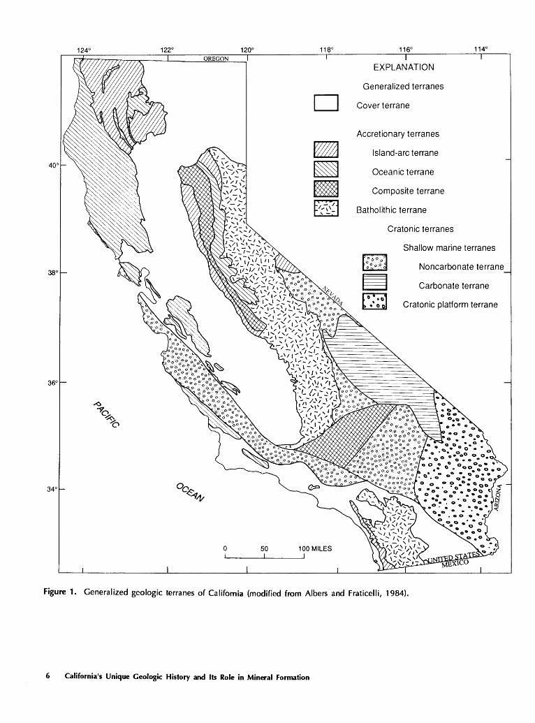
The major characteristics, origins, and typical mineral deposit types of each of the geologic terrane types in California (fig. 1) are outlined in this section. A more complete account of the mineral resources and potential of each major physiographic region in the State (fig. 2) is presented in the last part of this report.
Cratonic Platform Terrane
Cratonic platform terrane makes up a large part of the eastern California desert region and is therefore considered in some detail. A cratonic platform is part of the stable, tectonically inactive core of a continent, usually consisting of a complex of deformed metamorphic and igneous rocks overlain by flat-lying, stratified sedimentary rocks. In California, the cratonic platform terrane consists of a basement of Precambrian igneous and metamorphic rocks overlain by a thin sequence of upper Precambrian and Paleozoic sedimentary rocks, all intruded by granitoid plutons, mostly of Mesozoic age (Albers, 1981). The complex history of the Precambrian basement rocks is poorly understood at
2 California's Unique Geologic History and Its Role in Mineral Formation
present, due to lack of intense study, scarcity of outcrop, and deformation during and since late Precambrian time. The igneous and sedimentary protoliths of these basement rocks, however, probably formed in plate tectonic environments analogous to those of the present. The most significant mineral deposits associated with the cratonic platform terrane include disseminated-gold deposits, contact metasomatic (replacement) deposits of iron, replacement and vein deposits of silver, lead, or zinc, and the single largest rareearth-element deposit in the United States (Albers, 1981; Warhol, 1980).
Shallow Marine Terranes (Cratonic)
Shallow marine terranes consist of rocks that were deposited as a growing wedge of sediments along the continental shelf at the margin of a craton. In California, the thin layer of upper Precambrian and Paleozoic sedimentary rock that overlies the cratonic platform terrane of the Mojave and Sonoran Deserts thickens to the north and west, where it is part of a band of shallow marine sediments that extends from northern Canada to northern Mexico (Albers, 1981). This band can be divided into two parts: an eastern carbonate terrane, discussed first, that grades westward into a noncarbonate terrane dominated by clastic rocks.
Shallow Marine Carbonate Terrane
The shallow marine carbonate terrane consists primarily of thick carbonate units (limestone and dolomite) with very subordinate quartzite and shale. These rocks crop out primarily in the Basin and Range province and the northern Mojave Desert. The most significant mineral occurrences within this terrane are replacement and vein lead-silverzinc deposits and contact metasomatic and vein tungsten deposits, all found at or near contacts with Mesozoic intrusive rocks (Albers, 1981).
Shallow Marine Noncarbonate Terranes
The western part of the late Precambrian and Paleozoic band of shallow marine deposits, in contrast to the eastern part, consists mostly of quartzite and fine-grained clastic sedimentary rocks. This group of rocks, which crops out north, south, and west of the carbonate terrane, is transitional to deep marine sedimentary rocks found in western Nevada and in isolated exposures in the Sierra Nevada. These rocks host contact metasomatic and vein tungsten deposits, replacement and vein deposits of silver, lead, and zinc, and some gold-quartz vein deposits. The area southwest of the San Andreas fault between Point Arena and the Transverse Ranges, commonly called the Salinian block, is underlain by metamorphosed shallow
marine clastic rocks intruded by Mesozoic granitoid plutons. Metallic mineral deposits are extremely rare in the Salinian block.
Batholithic Terranes
Batholithic terranes are composed primarily of granitoid plutons that rose from zones of melting in and above long-lived subduction zones. Granitoid rocks commonly intrude other terranes, especially those adjacent to the batholiths themselves, but only those areas where the plutons occupy nearly all the exposed surface are referred to as batholithic terranes in this report. There are two such terranes in California, both of Mesozoic age: the Sierra Nevada and the Peninsular Ranges batholiths. The granitoid rocks of batholithic terranes are usually devoid of mineral resources except where they are in contact with other rocks, especially those composed of metasedimentary sequences that contain carbonate rocks. Commodities found within the batholithic terranes include tungsten, molybdenum, and tin in contact metasomatic and vein deposits, iron in contact metasomatic deposits, and gold in quartz veins.
Island-Arc Terranes
Island-arc terranes are typically dominated by volcanic and volcaniclastic rocks of basaltic to andesitic composition, locally intruded by gabbroic to dioritic plutons. These terranes commonly show evidence of compressive deformation, apparently related to the accretion of the terrane onto the continent and to later joining of other terranes. Island-arc terranes in California occur in the Klamath Mountains, the northwestern Sierra Nevada, and the Peninsular Ranges. In the northern areas they are present within larger zones that also include accreted oceanic and composite terranes, all of Paleozoic to early Mesozoic age. Islandarc terranes typically contain lead-silver-zinc-copper-iron massive sulfide deposits, gold-quartz veins, vein and disseminated deposits of copper, contact metasomatic and vein iron and tungsten deposits, and chert -associated and fissure deposits of manganese.
Oceanic Terranes
Modem oceanic crust is typically composed of a simple sequence of igneous rocks, crystallized at midocean ridges, overlain by fine-grained sediments deposited as the ocean floor moves away from the ridge. Ancient oceanic terranes now preserved within continents, however, are usually highly deformed, reflecting the extremely disruptive nature of the processes by which oceanic crust becomes joined to continents. Some oceanic terranes consist
Geologic Terranes 3

of preserved accretionary wedges of material scraped off the top of an oceanic plate as it is subducted; these highly disturbed rocks are known as melange. Other parts of oceanic terranes preserve somewhat less-disrupted deep marine sequences overlying an oceanic igneous sequence. In California, Paleozoic and Mesozoic oceanic terrane underlies much of the Coast Ranges and elongate bands within the western Sierra Nevada and Klamath Mountains. Oceanic melange makes up most of those rocks, especially in the Coast Ranges, but more complete sequences of deepwater oceanic sedimentary rocks are also present, underlain in some places by igneous oceanic crustal rocks.
Several types of mineral deposits are present within oceanic terranes. Podiform chromium and laterite nickel deposits are associated with ultramafic rock bodies, which are commonly present as tectonic blocks within melange and at the margins of oceanic terranes. Chert-associated manganese, sedimentary iron, and massive sulfide deposits are associated with the upper parts of oceanic igneous sequences, which are also present both as tectonic blocks and at terrane margins. Silica-carbonate mercury deposits, which are associated with altered ultramafic rocks, usually occur in oceanic melange. Vein, fissure, and disseminated deposits of silver, copper, iron, lead, zinc, manganese, and tungsten occur adjacent to and above magmatic intrusions into accreted oceanic terranes.
Composite Terranes
Two terranes in California contain complex mixtures of Paleozoic and Mesozoic rocks that suggest both oceanic and island-arc affinities. One of these is a belt in the western Sierra Nevada, and the other underlies the western Mojave Desert. The histories of these areas are still being studied and actively debated, and no final classification can be presented here. Mineral deposits in these composite terranes are the same as those associated with the oceanic and island-arc terranes.
Cover Terranes
Many parts of California have been covered by volcanic and sedimentary rocks deposited since the accretion of various oceanic and island-arc terranes onto the edge of the continent was completed in the latest part of the Mesozoic era. These materials cover large areas of the State: the Modoc Plateau, the Southern Cascade Range, the Great Valley, much of the coastline between Morro Bay and the Mexico border, and widespread areas in the California desert. Mineral resources in these cover rocks and sediments include all of the State's oil and gas deposits, placer deposits of gold and other heavy metals, volcanogenic uranium and gold, hot-spring mercury and gold, borate deposits, and deposits of many types of industrial minerals.
TECTONIC HISTORY OF CALIFORNIA
A detailed account of the tectonic history of California, which spans at least 1. 7 billion years and remains the subject of active debate among geologists, is far beyond the scope of this report. The following highly simplified and generalized account is a summary largely excerpted from Dickinson (1981).
Little is known about the early geologic history of California. The oldest rocks in the state record a metamorphic event that occurred 1.7 billion years ago, and there is considerable evidence for an episode of alkaline plutonism about 1.4 billion years ago (De Witt and others, 1987). The continent may have extended much farther west during this period; some geologists believe a western extension of North America was rifted away during the Late Precambrian.
During latest Precambrian and early Paleozoic time the west edge of the North American continent was bounded by a passive margin similar to that of the present North American Atlantic coast; cratonic crystalline rocks were overlain by a wedge of shallow marine sedimentary rocks that formed the continental shelf. During this period, marine sediments were deposited on and adjacent to the craton.
From late Paleozoic through early Mesozoic time, the northwest edge of the continent was characterized by a complex pattern of offshore island arcs and marginal seas, probably similar to that of the western Pacific Ocean today. Several of the island-arc, oceanic, and composite terranes of California were created during this interval, although they may have been far from the continent when they formed. By the end of early Mesozoic time, the seas separating these island arcs from the continent had closed, and the easternmost of the oceanic and island-arc terranes of the western Sierra Nevada and the Klamath Mountains became attached to the craton, expanding the continent to the west.
Subduction moved closer to the continent in middle Mesozoic time; the west margin of the continent during the last two-thirds of the Mesozoic era was broadly similar to that of the present-day west edge of South America. This type of margin is characterized by a deep trench separated from its associated continental volcanic arc by an accretionary wedge of disrupted oceanic material (melange), scraped off the subducting plate, and a forearc basin in which volcanogenic sediments from the arc are deposited. The batholithic terranes of the Sierra Nevada and the Peninsular Ranges formed in this setting; they represent roots of a continental magmatic arc, now exposed by uplift and erosion of the volcanic cover. This continental magmatic arc penetrated the cratonic terranes of the present-day California desert region, creating the Mesozoic plutonic and volcanic rocks that underlie much of the region {Tosdal and others, in press); the arc was probably also the source of the
4 California•s Unique Geologic History and Its Role in Mineral Formation
plutons in the Salinian block of the southern Coast Ranges. Additional oceanic, island-arc, and composite terranes of the western Sierra Nevada and Klamath Mountains were also added to the continent during this period, as one or more island arcs collided with the continental margin. Rocks of the oceanic terranes of the Coast Ranges, consisting mostly of melange (but including less-disrupted sequences of sediments), formed just landward of the trench during late Mesozoic time, and the Great Valley sequence of sediments filled a forearc basin that separated the magmatic arc from the trench.
During the later part of the Cenozoic era, subduction in the southern half of present-day California began to give way to transform motion along faults of the San Andreas system, and the rocks southwest of the fault were transported hundreds of miles northwestward. North of Cape Mendocino, where the San Andreas fault veers westward into the Pacific Ocean, subduction continued, and the accompanying magmatism resulted in the late Cenozoic and Quaternary volcanism that characterizes the Modoc Plateau and the Cascade Range. Crustal extension (stretching) in eastern California and Nevada during this period led to the formation of the elongate mountains and valleys that characterize the Basin and Range province.
The coastal region from Morro Bay to Mexico is covered by Cenozoic sedimentary rocks, and the Great Valley is filled to great depths with late Mesozoic and Cenozoic sediments shed from the Sierra Nevada and the Coast Ranges. Older terranes beneath the Cascade Range and Modoc Plateau areas are completely hidden beneath late Cenozoic to Holocene volcanic rocks. All of these areas are classified as cover terrane.
CALIFORNIA MINERAL POTENTIAL
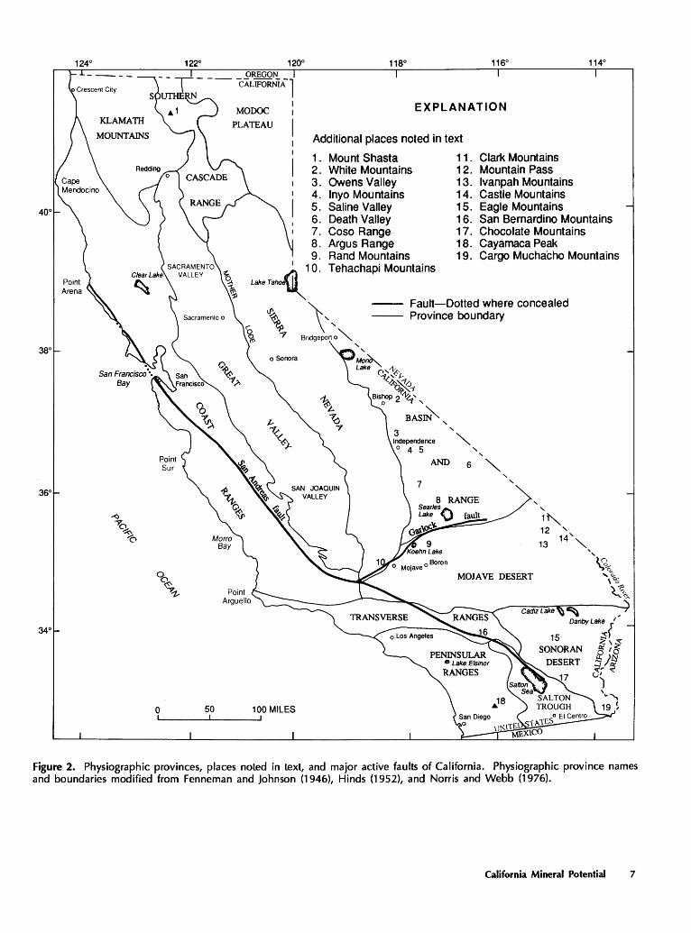
In this section, the mineral resources of each of the major physiographic regions in California (fig. 2) are considered separately. The province names and boundaries follow or are modified from those of Fenneman and Johnson (1946), Hinds (1952), and Norris and Webb (1976). Most of the physiographic provinces are composed of more than one geologic terrane, so they often have more than one set of associated mineral deposit types. The California desert region is discussed here in greater detail than the other regions in the State.
A simple classification system for mineral resource potential is used in this report. Areas are considered to be permissive for the occurrence of mineral deposits if they contain rock assemblages commonly associated with one or more types of mineral deposits. In general, areas are classified as permissive for the occurrence of mineral deposits if they were classified as geologically favorable by Albers and Fraticelli (1984). (The word "favorable," in reference to mineral potential, is now usually applied to relatively
small areas that have other characteristics, in addition to rock assemblage, that are similar to those of areas known to contain mineral deposits.) In some cases, the areas classified as permissive in this report contain smaller areas that are considered favorable for the occurrence of mineral deposits, but the identification of such areas is beyond the scope of this report.
California Desert Region
Introduction
The California desert region includes all or parts of three different physiographic provinces: the Basin and Range province in the north, the Mojave Desert province in the middle, and the Sonoran Desert in the southeast. The region is bounded on the northwest by the Sierra Nevada and Tehachapi Mountains, on the southwest by the eastern Transverse Ranges and the Peninsular Ranges, and on the east by the Nevada State line and the Colorado River. The Basin and Range province is separated from the Mojave Desert by the Garlock fault and a projected eastward extension of the fault; the boundary between the provinces is gradational in the east, but quite sharp along the Garlock fault itself. The boundary between the Mojave and Sonoran Deserts is arbitrary but corresponds roughly with a change in average elevation; the mean elevation of the Mojave Desert is about 2,500 feet, while elevations in the Sonoran Desert are generally much lower. The Mojave and Sonoran Deserts are characterized by low mountain ranges rising out of an alluvial cover of varying thickness; these low ranges have no particular orientation in most areas, but in some places they have a general northwesterly trend. In contrast, the Basin and Range province is characterized by elongate, approximately north-south-trending mountain ranges and basins. In California, elevations in the Basin and Range province range from below sea level in Death Valley to over 14,000 feet in the White Mountains. Drainage is internal throughout the California desert region except in the eastern part of the Sonoran Desert province, which is drained into the Gulf of California via the Colorado River.
The desert region in California is geologically different from the rest of the State in several aspects, which are reflected in the variety and types of mineral deposits of the region. First, the crystalline rocks that form the basement of the region are the oldest rocks in the State. One type of important mineral deposit (rare-earth-element-rich carbonatite) is restricted to a single known occurrence in these rocks, and the potential for additional rare-earth-element deposits of this type in the State is restricted to the California desert region. Second, during parts of the late Cenozoic era an unusual combination of climatic and geologic conditions led to the formation of extensive boron-rich evaporite
California Mineral Potential 5
122° 120° 118° 116° 114° OREGON
EXPLANATION
Generalized terranes
D Cover terrane
Accretionary terranes
Island-arc terrane
Oceanic terrane
Composite terrane
Batholithic terrane
Cratonic terranes
Shallow marine terranes
Noncarbonate terrane
Carbonate terrane
Cratonic platform terrane
0 50 100 MILES
Figure 1. Generalized geologic terranes of California (modified from Albers and Fraticelli, 1984).
6 California•s Unique Geologic History and Its Role in Mineral Formation
340
0 50
MODOC
PLATEAU
EXPLANATION
Additional places noted in text
1 . Mount Shasta 11 . 2. White Mountains 1 2. 3. Owens Valley 13. 4. lnyo Mountains 14. 5. Saline Valley 15. 6. Death Valley 16. 7. Coso Range 1 7. 8. Argus Range 1 8. 9. Rand Mountains 1 9.
Clark Mountains Mountain Pass lvanpah Mountains Castle Mountains Eagle Mountains San Bernardino Mountains Chocolate Mountains Cayamaca Peak Cargo Muchacho Mountains
' 10. Tehachapi Mountains Lai<OTa~
Fault-Dotted where concealed Province boundary ~ '\>
\ Bridgeport o"""
' ' Mo~ Lake C''~~t.
-1(~:::..._-1() ~~-1
Bis~p 2 ~',
BAS~, '
""" ' ' ANDs"'-' '
MOJAVE DESERT
' ' 1~ 12 ' 13 14'",
'~ q._ ...... \"'6
~ ... L. <:...
100 MILES
Figure 2. Physiographic provinces, places noted in text, and major active faults of California. Physiographic province names and boundaries modified from Fenneman and Johnson (1946), Hinds (1952), and Norris and Webb (1976).
California Mineral Potential 7
deposits. Borate deposits in the United States are confined to the California desert and the adjacent region of Nevada, and all present production is from California. Finally, the region has an unusually complex geologic history. Many rock types are present, and the entire area has been subjected to long episodes of intrusive and extrusive magmatism, accompanied by periods of both compressional and extensional deformation. Most areas are cut by faults related to one of the deformational episodes, and many of the rocks that are not themselves magmatic in origin show evidence of alteration due to magmatic heat and fluids. Most types of metallic mineral deposits, worldwide, are related (directly or indirectly) to heat and fluids associated with the rise and emplacement or eruption of magma; faults commonly serve both as channels for mineralizing fluids and as sites of mineral deposition. In summary, the California desert region has the necessary ingredients for the formation of many different types of mineral deposits: a great variety of rock types and compositions, long episodes of magmatism, and an abundance of faults in a variety of orientations.
Geologic History of the Region
The beginnings of the geologic history of the California desert region are enigmatic. The oldest rocks in the region are schists and gneisses that formed during a metamorphic event about 1. 7 billion years ago, but the ages of the igneous and sedimentary rocks from which they formed are unknown. At least two intrusive episodes apparently occurred during the approximately 1-billion-year interval between the earliest metamorphism and the beginning of shallow marine deposition in late Precambrian time, but little else is known about the history of the region during this time interval. From an economic standpoint, the most significant of these intrusive pulses was the emplacement of alkaline plutonic rocks, including carbonatite, about 1.4 billion years ago. Some workers (for example, Stewart, 1972, and Dickinson, 1981) hypothesize that the continent extended much farther west during this period and that the western part was rifted away during the late Precambrian, thus setting the stage for shallow marine sedimentation. The remaining Precambrian crystalline rocks form the basement of the California desert's cratonic terranes.
Beginning in the late Precambrian and continuing throughout the Paleozoic, shallow marine sediments were deposited on the margin of the craton. These rocks are thin on the cratonic platform terrane (south of the Garlock fault), but they thicken considerably in the Basin and Range province to the north. Oceanic sedimentary rocks and island-arc(?) volcanic rocks of about the same age are present in the northwestern Mojave Desert, but their origin is uncertain; for the purposes of this report they are grouped as composite terrane.
Beginning in the late Triassic, the magmatic arc that formed the Sierra Nevada batholith also extended through
the present-day desert region. Much of the Mesozoic era was characterized by repeated episodes of deformation, evidence of which is preserved in the geologic record as east-directed thrust faults in the northeastern part of the region and east-verging folds in the southwest Mesozoic plutonic rocks make up more than half the exposed rocks in the Mojave and Sonoran Deserts (Dibblee, 1980) and are less common (but nevertheless abundant) in the Basin and Range province. Mesozoic volcanic rocks are also present but not widespread, probably because most were removed by erosion during the Cenozoic era. Magmatic activity in the California desert region continued into the Cenozoic, but most of the exposed magmatic rocks of Cenozoic age are volcanic rather than plutonic. In most cases the upper levels of these relatively young magmatic systems have not yet been removed by erosion, and their deep intrusive roots remain unexposed.
In late Cenozoic time, the entire region was transformed into an area of internal drainage by uplift along its west margin. Local uplifts and depressions associated with crustal extension occurred at many places in the region, creating numerous closed drainage basins. These basins became sites of deposition for lacustrine (lake) sediments, volcanic and volcaniclastic rocks, and (or) evaporite deposits similar to those now forming in dry lakes or playas at many places in the California desert region. As a result of the lack of external drainage, thick Quaternary sedimentary sequences cover much of the region, especially the western part of the Mojave Desert, and relatively thin sequences of sediment locally cover bedrock adjacent to the mountains.
History of Mineralization
The history of mineralization of the California desert region parallels its geologic history. The length and complexity of the geologic history has provided numerous opportunities within the past 1.7 billion years for the concentration and deposition of mineral resources. Two of the most notable deposit types--the rare-earth-element deposit at Mountain Pass and numerous borate deposits in the region-are, respectively, among the oldest and youngest kinds of deposits found in the region.
The most significant Precambrian deposit-forming event was the intrusion of alkaline plutons about 1.4 billion years ago. Among these plutons was at least one carbonatite intrusion, now exposed at Mountain Pass, near the Nevada border. Other rare-earth-element-bearing carbonatite bodies may exist in the California desert region, but none are presently known.
Little mineralization of late Precambrian or Paleozoic age is known. The thick sequences of limestone and dolomite that were deposited in the shallow marine carbonate terrane of the northern Mojave Desert and Basin and Range province, however, later served as host rocks to numerous deposit types associated with the intrusion of magmas. Reaction between the carbonate rocks and
8 California's Unique Geologic History and Its Role in Mineral Formation
younger hydrothermal fluids was an essential part of the deposit-forming process.
Most of the metallic mineral deposits in the California desert region were formed in association with Mesozoic and Cenozoic magmatism and deformation. Emplacement of magma into the upper crust provided both the heat and the fluids that are critical for the formation of many types of mineral deposits, and faults provided channels for the movement of the fluids. The details of mineral deposit genesis are beyond the scope of this report, but a short description of the general features of magmatic mineral deposit formation may be useful.
During the rise and emplacement of magma bodies into overlying rocks, magmatic fluids are released into the surrounding rocks, and meteoric water already in the rocks becomes heated. Under appropriate conditions, reactions between the host rocks and these fluids result in mineral deposits. In some cases these deposits occur adjacent to magmatic intrusions; the tungsten and the iron contact metasomatic (skarn) deposits of the California desert region, for example, occur along the contacts between granitoid rocks and carbonate rocks. Often, however, mineral deposits occur at some distance from intrusions; many kinds of vein deposits and replacement deposits form where hydrothermal fluids, traveling along faults or fractures, react with appropriate host rocks or simply precipitate metallic minerals as they cool. The lead-silver-zinc replacement deposits and many kinds of vein deposits (including gold, silver, tungsten, lead, zinc, and copper) are examples found in the California desert region.
During late Cenozoic time, an unusual combination of geologic, topographic, and climatic conditions led to the formation of large borate and other evaporite mineral deposits. Evaporite deposits form when large amounts of water are removed from a closed basin by evaporation, creating first a saline lake and then a dry lake or playa Borate minerals, like other evaporites, may precipitate either when saturation is reached in a drying saline lake or when boron-rich thermal water enters and reacts with water in a cooler saline lake. Three factors are needed to create borate deposits: ( 1) basins with no external drainage; (2) periods of relatively arid climate, to maintain or increase the salinity of the lakes by high evaporation; and (3) a source of boron. The extensional tectonic regime that characterized much of the desert region during the. later part of Cenozoic time led to the formation of closed basins. The dry climate may have resulted from (or at least been enhanced by) the rise of substantial mountain ranges to the west that created rain shadows over the desert region. The boron is believed to have originated in boron-rich hot springs (Carpenter, 1980; Siefke, 1980). The borate deposits of the California desert region are among the largest and most productive in the world; in recent years, production from the desert region has made the United States one of the world's two largest producers of borates (Lyday, 1988; Carillo and others, 1987).
More than 60 percent of the California desert surface is covered by alluvial deposits that prevent direct examination and exploration of bedrock. Assuming that the rock types and geologic structures seen in exposures of bedrock continue under this alluvial cover, it is very probable that undiscovered mineral resources similar to those already discovered in exposed bedrock are present beneath the alluvium. Exploration of bedrock beneath sedimentary cover is difficult at present, and production of resources from depth is more expensive than surface mining. Because subsurface data is very scarce, no assessment of the mineral resource potential of bedrock beneath alluvium is included in this report. Future developments in exploration and mining technology, however, are likely to make the discovery and production of buried resources in the California desert region possible and economically feasible.
History of Mineral Resource Production
The earliest development of mineral resources in the California desert region was probably by Native American populations who gathered such materials as clay and turquoise (Davis and Anderson, 1980). Gold and silver mines were in operation by the end of the 18th century, and production has continued intermittently to the present. Most production has been from bedrock, but gold has also been produced from placer deposits in at least three mining districts in the California desert region (Clark, 1980). Accurate production figures for gold and silver are not available, but total production of gold from the California desert region certainly exceeds 3 million ounces, and annual production from the desert region has been rapidly rising during the past 5 years. Gold production from the desert was about 5,000 ounces in 1982, while anticipated production totals for 1987 and 1988 are 255,000 ounces and 305,000 ounces, respectively (Anderson, 1987). Total gold production for the State was about 108 million ounces as of 1987, with about a third of that taken from goldquartz vein deposits in the northern Sierra Nevada Since 1982, the rate of gold production in California has been more than doubling every year (Lucas, 1988). The largest contact metasomatic iron deposits in the State are located in the California desert region, where well over 100 million tons of ore have been produced (Scott and Wilson, 1980). Other metallic mineral commodities that have been produced in smaller amounts include antimony, bismuth, cadmium, lead, lithium, manganese, magnesium, mercury, tin, tungsten, uranium, vanadium, and zinc (Davis and Anderson, 1980).
Production of nonmetallic mineral commodities also has a long history in the California desert region. Development of borate resources in the region began with production from playas in the 1870's. Most borate production shifted to richer bedded deposits about 1890, except at Searles Lake, where production of borates and other salts from brine continues. Bedded borates (kernite, ulexite,
California Mineral Potential 9
probertite, or colemanite) are mined at Boron and were mined in Death Valley until 1986. In recent years, the California desert region has been the source of all U.S. production and one-third to one-half of the worldwide production of borates (Lyday, 1988; Carillo and others, 1987). The largest producing rare-earth deposit in the western world is at Mountain Pass (Warhol, 1980); it was discovered in 1949, and development started soon thereafter. During the 20th century, population growth in the California desert region and adjacent areas, especially the Los Angeles and San Diego metropolitan areas, has increased the demand for significant production of industrial materials such as sand, gravel, aggregate, perlite, clay, limestone, and gypsum. At present, the value of nonmetallic mineral commodities produced from the California desert region (including borates, rare-earth elements, and industrial minerals) exceeds that of the metallic commodities from the region (Carillo and others, 1987).
Metals
More than half of the exposed bedrock in the California desert region is considered geologically permissive for the existence of undiscovered mineral deposits (Albers and Fraticelli, 1984). These permissive areas, widely scattered throughout the desert, are separated by alluvial cover and by bedrock that is not considered geologically permissive for mineral resources and that lacks known deposits. Alluvium may contain placer deposits of gold or other commodities. About a third of the area underlain by permissive bedrock has numerous known deposits. In order to facilitate description of the mineral resources and potential of the five geologic terranes that underlie this large region, each terrane is discussed separately.
The cratonic platform terrane, which underlies most of the Sonoran Desert and the eastern third of the Mojave Desert, has numerous areas that are geologically permissive for mineral deposits of gold, iron, copper, tungsten, manganese, lead, zinc, or silver. About a third of this area contains known deposits of one or more of these metals. For more than 30 years, most mining activity in the cratonic platform terrane was focused on contact metasomatic iron deposits, but major production of iron ore has ceased. The largest producer of iron ore was the Eagle Mountain iron mine, located in the Eagle Mountains in the southern part of the cratonic platform terrane. It opened in 1948 and produced more than 100 million tons of ore before closing in 1984 (Scott and Wilson, 1980; Burnett, 1985). At present, disseminated-gold deposits are the most important metallic mineral deposits in the region; most present exploration and mining activity in the area is directed toward finding and developing these deposits. Large disseminatedgold deposits include the Mesquite and Picacho mines in the Chocolate Mountains, the Morning Star mine in the Ivanpah Mountains, and the Colosseum mine in the Clark
Mountains. These four mines are expected to have combined production of at least 300,000 ounces of gold per year (Anderson, 1987; Lucas, 1988; Carillo and others, 1987). In these deposits, the gold occurs as extremely fine grained particles, usually invisible to the naked eye. The characteristics and settings of disseminated-gold deposits are apparently quite varied. Tosdal and Smith (1987) describe the the Mesquite deposit as a large gneiss-hosted epithermal vein deposit in brecciated or fractured host rock. They associate deposits in the Cargo Muchacho Mountains with aluminous, kyanite-bearing gneisses and schists. Some of the Cargo Muchacho deposits may be metamorphosed gold-skarn deposits (Orris and others, 1987), closely associated with the metasomatic iron (iron skarn) deposits of the region. Bouley (1986) describes the occurrence of disseminated gold in breccia on low-angle detachment faults that cut crystalline and volcanic rocks and cites the Picacho mine as an example. In the Hart mining district, located in the Castle Mountains, disseminated-gold deposits are hosted by volcanic rocks.
Shallow marine noncarbonate terrane underlies the central part of the Mojave Desert, west of the cratonic platform terrane. Much of the exposed bedrock in this area is considered permissive for iron, gold, lead, zinc, or copper, and a few areas are considered permissive for silver, tungsten, or mercury. About a quarter of the area considered permissive for one or more of these commodities contains known mineral deposits. As in the cratonic platform terrane, most known metallic mineral resources occur in contact metasomatic iron deposits and in replacement or vein deposits of the other commodities.
The western Mojave Desert is underlain by terrane of debatable origin. In this report it will be considered to be composite (oceanic and island-arc) terrane, following Albers and Fraticelli (1984). Most of the region is not considered permissive for metallic mineral deposits, but there are significant exceptions to this generalization. Several areas within the region are considered permissive for gold, tungsten, lead, or zinc, and some of these permissive areas contain known deposits of gold. The mineralized area in the vicinity of the Rand Mountains is considered permissive for deposits of tungsten, gold, silver, manganese, and antimony and contains known deposits that include the vein-type tungsten deposit at Atolia and the gold-quartz vein deposits of the Randsburg mining district.
Shallow marine carbonate terrane underlies much of the California Basin and Range province and part of the northern Mojave Desert. Much of the exposed bedrock in this terrane is considered geologically permissive for lead, silver, zinc, tungsten, or silver, and about a quarter of this area contains known deposits of these metals. The major deposits in this area are lead-silver-zinc replacement and vein deposits and contact metasomatic tungsten deposits. An area in the southwestern part of the carbonate terrane, in the vicinity of the Coso and Argus Ranges, is considered
1 0 California's Unique Geologic History and Its Role in Mineral Formation
geologically permissive for gold, manganese, molybdenum, and mercury, but known deposits are sparse. Berger ( 1986) describes deposits containing extremely fine grained gold and silver in certain types of carbonate rocks that have been intruded by magma; the large deposit at the Carlin mine in north-central Nevada is an example. Similar deposits may exist in the shallow marine carbonate terrane of the California desert region.
Shallow marine noncarbonate terrane underlies the part of the California Basin and Range province north and west of the carbonate terrane. Bedrock there is considered permissive for gold, tungsten, lead, silver, zinc, or copper. About a third of this area contains known deposits of one or more of these commodities. As in the adjacent shallow marine carbonate terrane, most of the deposits in this area are contact metasomatic tungsten deposits and lead-silverzinc replacement and vein deposits.
Special Metals (Rare-Earth Elements, Uranium)
Precambrian rocks at Mountain Pass contain the largest producing rare-earth-element deposit in the western world. Economic deposits of rare-earth elements are commonly found in carbonatite, a rare kind of igneous rock containing carbonate minerals. According to Singer (1986), these deposits typically occur in cratonic terranes and are spatially related to fault lineaments and alkaline volcanism. In the deposit at Mountain Pass, the rare-earth elements occur in the mineral bastnaesite (a fluorocarbonate) that makes up about 10 percent of an approximately 1.4-billion-year-old carbonatite body that intrudes still older gneiss (DeWitt and others, 1987; Woyski, 1980). The rare-earth elements in the Mountain Pass deposit are cerium, lanthanum, neodymium, praesodymium, samarium, gadolinium, and europium, in order of decreasing abundance; cerium and lanthanum make up about 85 percent of the rare-earth elements in the deposit (Warhol, 1980). Although other rare-earth-element deposits are not known in the California desert region, Precambrian crystalline rocks are considered geologically permissive for additional deposits.
Cenozoic intermediate to silicic volcanic rocks throughout the region are considered geologically permissive for uranium deposits, but known deposits are sparse. Sediments derived principally from these rocks are also considered geologically permissive (for example, uraniumbearing volcanogenic sediments are present near the Coso Range).
Nonmetallic Commodities
Among the most important nonmetallic commodities found in the California desert region are borate and associated evaporite minerals and saline brines, collectively known as saline deposits. The origins of these deposits are
discussed above. The lower parts of most of the closed basins in the California desert region are considered geologically permissive for saline deposits, and most of them contain known deposits. Examples include Death Valley, Saline Valley, Searles Lake, Cadiz Lake, Danby Lake, and Koehn Lake. Borate minerals do not occur in all of these areas; common salt (sodium chloride) is recovered from saline brine by evaporation at several locations.
Deposits of industrial minerals occur throughout the California desert region. Sand and gravel deposits are abundant in the alluvium that covers much of the region (Leighton, 1980). Notably pure and uniform deposits of limestone and dolomite are present in many of the late Precambrian and Paleozoic carbonate sequences that occur in places in the cratonic platform terrane of the Mojave and Sonoran Deserts and form the shallow marine carbonate terrane of the Basin and Range province (Gray and Bowen, 1980). Development of these deposits has been hindered by the high cost of transporting them to markets along the Pacific coast, but as sources closer to the coastal markets are depleted and desert population centers grow, these resources may become more important. Pumice, perlite, and cinder deposits are mined in several places in the California desert region, and Cenozoic volcanic rocks are geologically permissive for additional deposits of these commodities. Eleven areas in the western Mojave Desert and two areas in the Basin and Range Province contain known zeolite resources (Stinson, 1984).
There are four Known Geothermal Resource Areas (KGRA's) in the California desert region. The largest of these is the Coso field, adjacent to the Coso Range, which is being developed for electric power generation (Collie, 1978; Anderson, 1987). Eight other areas, scattered throughout the California desert region, have known nearsurface thermal waters (Majmundar, 1983).
Peninsular Ranges and Salton Trough
The Peninsular Ranges and Salton Trough areas of California are located in the southern part of the State, primarily southwest of the San Andreas fault The geologic history of the Peninsular Ranges should be considered along with that of Mexico and Central America, as the area has been moved northwestward at least 200 miles since motion along the San Andreas fault began in the Miocene; some evidence, based on paleomagnetic measurements, suggests that the Peninsular Ranges have moved much farther than 200 miles. Most of the region is underlain by a batholithic terrane similar in age and composition to the Sierra Nevada batholith. Granitoid plutons of this terrane intrude an island-arc terrane along the west edge of the range and a shallow marine noncarbonate terrane in the northern part of the area. Tertiary volcanic rocks cover scattered parts of these areas. Details of the geologic history of the Peninsular Ranges are beyond the scope of this
California Mineral Potential 11
report, but the same kinds of geologic events (if not the same sequence) that created the terranes of the Sierra Nevada northeast of the San Andreas fault must also have led to the formation of the geologic terranes of the Peninsular Ranges.
The Salton Trough is a pull-apart basin created by strike-slip (horizontal) motion on the San Andreas fault. The basin is filled to considerable depths with sediment, but mineral resource potential is restricted to saline ( evaporite) deposits at or near the surface. The Salton Trough also has significant known and potential geothermal energy resources.
The most notable mineral deposits in the Peninsular Ranges are lithium minerals and gemstones in pegmatites. Pegmatites are found only in areas underlain by plutonic rock; batholithic terrane in the region is considered geologically permissive for undiscovered lithium and gemstone deposits.
Large metallic mineral deposits have not been discovered in the Peninsular Ranges or Salton· Trough provinces, but two areas in the Peninsular Ranges do have numerous small deposits of gold, tungsten, copper, and other metals. Part of the northern Peninsular Ranges, near Lake Elsinor, has deposits of gold, tungsten, copper, antimony, manganese, lead, or zinc. The area northeast of Cayamaca Peak (about 40 miles from San Diego) has deposits of copper, nickel, silver, gold, and manganese. Both areas are considered geologically permissive for the discovery of additional deposits.
Most of the western Peninsular Ranges area is considered geologically permissive for copper, gold, manganese, iron, or nickel, but there are few known deposits in this area. Tertiary volcanic rocks, which occur in scattered localities throughout the eastern Peninsular Ranges, are considered geologically permissive for deposits of uranium, but known deposits are sparse or absent. Areas within several basins in the eastern Peninsular Ranges and parts of the Salton Trough are considered geologically permissive for saline (evaporite) deposits. Some of these areas, including a large area southeast of the Salton Sea, contain known deposits of evaporite minerals or saline brines. The large gypsum deposits near El Centro are an example. The Salton Trough also contains seven KGRAs that together have substantial identified electric-energy potential (Nathenson and Muffler, 1975; Collie, 1978; Majmundar, 1983). Five geothermal power plants are currently operating in these areas. The rest of the Salton Trough area is considered geologically permissive for additional geothermal energy resources.
Transverse Ranges
The Transverse Ranges trend approximately east-west, nearly perpendicular to the general north-northwesterly
grain of most geologic and physiographic features in California. The ranges extend from Point Arguello on the Pacific Ocean to the San Bernardino Mountains in the east, where the province grades into the Mojave and Sonoran Desert provinces. The western part of the Transverse Ranges province is underlain by Cenozoic marine and nonmarine sedimentary rocks. These rocks are not known to contain metallic mineral deposits, but they do contain many reservoirs of oil and gas from which considerable production has taken place. The offshore extensions of the producing formations are also known to contain oil and gas, and development of these deposits is underway.
Noncarbonate shallow marine terrane underlies the eastern Transverse Ranges. About half of this area is considered geologically permissive for gold, copper, lead, zinc, manganese, iron, or titanium, and about half of the geologically permissive area contains known deposits of one or more of these metals. Deposit types include chertassociated manganese, gold-quartz veins, and anorthosite titanium.
Sierra Nevada
The Sierra Nevada extends 400 miles from the Modoc Plateau in the north to the Mojave Desert in the south; it varies in width from 40 to 100 miles. The range is highest and most rugged along much of its east edge, and overall elevation gradually decreases to the west. The range can be divided into western and eastern belts that have geologically different characteristics. The western belt, along the west edge of the north half of the range, consists of Paleozoic to Mesozoic oceanic, island-arc, and composite terranes that are intruded by Mesozoic quartz dioritic to granodioritic plutons. These three terranes form bands that parallel the trend of the range; generally the oceanic band is closest to the core of the range, and the island-arc band lies along the west edge. The eastern belt of the Sierra Nevada is batholithic terrane, composed almost entirely of Mesozoic granodioritic to granitic plutons that enclose remnants of older Mesozoic deep marine volcanic and clastic rocks in its western part and Paleozoic shallow marine quartzose and carbonate rocks in the eastern part. The different geologic characters of the eastern and western belts are reflected in the different mineral deposit types found in these two regions.
The western belt is historically important as the center of the California gold-rush activity in the middle 19th century. The Mother Lode is in the western belt, and about a third of California's total gold production was taken from gold-quartz veins in this region; the belt contains nearly all the large lode-gold deposits in California (Albers, 1981). Virtually the entire western belt is considered geologically permissive for mineral deposits containing gold, chromium, nickel, copper, zinc, manganese, or mercury, and about a
12 California's Unique Geologic History and Its Role in Mineral Formation
third of the belt has numerous known deposits of one or more of these metals. The large disseminated-gold deposit at Jamestown, southwest of Sonora, lies within the western belt. Gold-quartz vein deposits are found in all three terranes of this belt, but the occurrence of the other common mineral deposit types is more restricted. Podiform chromite and laterite nickel deposits are associated with ultramafic rocks that occur most often within or at the margins of oceanic and composite terranes. Chert-associated manganese deposits occur mostly in oceanic and composite terranes, but they also occur in a small area of island-arc terrane that lies northeast of the oceanic band at the north end of the range. Pyritic massive sulfide deposits are restricted to the island-arc band.
Mineral resources in the batholithic eastern belt of the Sierra Nevada are mostly restricted to roof pendantsbodies of metamorphic rock caught between or within plutons. The majority of granitoid bodies in the batholith are devoid of known mineral deposits (except where they are in contact with roof pendants) and are not considered to be geologically permissive for undiscovered mineral deposits. The most common commodity found in the batholithic terrane is tungsten, which occurs in skarn deposits at contacts between metamorphic carbonate rocks and granitoid plutons. California ranks first in tungsten production in the United States (Carillo and others, 1987), and the Pine Creek deposit near Bishop (east-central edge of the range) is the largest deposit of this type in California.
North of Lake Tahoe, the Sierra Nevada batholith contains a few roof pendants that have deposits of, and are geologically permissive for, tungsten or gold. Much of the area between Lake Tahoe and Bridgeport is considered geologically permissive for gold, tungsten, mercury, manganese, or uranium in skarn deposits in roof pendants and in hot-spring, vein, and other deposits in Cenozoic volcanic rocks, but known deposits are sparse or absent. South of Bridgeport, the batholithic terrane contains numerous roof pendants; collectively, these bodies have numerous deposits of, and are considered to be geologically permissive for, tungsten and molybdenum in skmn deposits, gold in quartz veins, iron in epigenetic magnetite deposits, or chromium in podiform chromite deposits that occur in roof pendants of oceanic affinity along the west edge of the batholith. Batholithic rocks along the central east edge of the Sierra Nevada, from Mono Lake to Independence, contain numerous roof pendants and are considered to be geologically permissive for deposits of tungsten and gold. Deposits of tungsten, gold, or molybdenum occur locally, but known deposits are sparse or absent in most of this area. Most of the Sierra Nevada south of the 36th parallel is considered to be geologically permissive for gold, tungsten, lead, zinc, antimony, or mercury in roof-pendant skarn deposits or in gold-quartz and other vein deposits. Known deposits of gold, tungsten, antimony, or mercury occur in parts of the area, but most of the area lacks known deposits.
Great Valley
The Great Valley, the elongate valley that lies between the Sierra Nevada and the Coast Ranges, is filled to great depths with sequences of marine and nonmarine sediments and sedimentary rocks shed from the Sierra Nevada, the Coast Ranges, and their ancestors since late Mesozoic time. The Great Valley contains no known metallic mineral deposits and is not considered geologically permissive for undiscovered metalliferous deposits. However, the sedimentary rocks of the Great Valley contain oil and natural gas in large quantities. Both oil and gas are present in the southern half of the valley (San Joaquin Valley); the northem section (Sacramento Valley) contains large deposits of dry natural gas. Mercury deposits occur along the boundary between the Great Valley and the Coast Ranges provinces. In this report they are included in the discussion of the Coast Ranges.
Coast Ranges
The California Coast Ranges are divided by the San Andreas fault into two separate regions: the northern Coast Ranges, northeast of the fault, and the southern Coast Ranges, southwest of it. The northern Coast Ranges are underlain entirely by oceanic terrane, while the southern Coast Ranges can be divided into two parallel segments: a wide band of shallow marine noncarbonate terrane lies adjacent to the San Andreas fault, and a narrower band of oceanic terrane lies to the southwest, along the coast from Point Sur to Morro Bay. Much of the southern end of the Coast Ranges is underlain by Cenozoic sedimentary rocks like those that make up much of the western Transverse Ranges.
More than half of the oceanic terrane in both parts of the Coast Ranges is made up of the Franciscan Complex, which consists of blocks of sandstone, graywacke, and chert-greenstone units separated by melange zones that consist of smaller blocks of the above units along with serpentinite, blueschist, eclogite, chert, limestone, and mafic and ultramafic rocks, all in a sheared argillaceous matrix. The most characteristic feature of the Franciscan Complex is its extreme structural disorder, which is thought to have developed as the unit was scraped off a subducting oceanic plate and accreted onto the continent. The entire Franciscan Complex is considered geologically permissive for deposits of chert-associated manganese and silica-carbonate-hosted mercury. Small bodies of ultramafic rock occur locally throughout the Franciscan Complex; areas containing these exposures are considered permissive for podiform chromium deposits. However, only a small part of the area underlain by the Franciscan Complex contains known deposits of any of these commodities. The Coast Ranges oceanic terranes also include large areas underlain by relatively undisturbed Mesozoic marine sedimentary sequences
California Mineral Potential 13
that are not considered pennissive for mineral deposits. Some of the Cenozoic volcanic rocks in the central part of the northern province, between Clear Lake and the San Francisco Bay, are considered pennissive for epithennal hot-spring gold and mercury deposits. The McLaughlin gold mine southeast of Clear Lake is an example of a large mine of this type. Significant geothennal energy resources are present in the northern Coast Ranges. The Geysers KGRA, south of Clear Lake, contains the largest geothermal electric-power-generation installation in the world (Majmundar, 1983), and the region surrounding the KGRA is considered geologically permissive for additional geothennal resources (Collie, 1978).
The shallow marine noncarbonate terrane of the southem Coast Ranges (also known as the Salinian block) is composed principally of metamorphosed clastic sedimentary rocks intruded by Mesozoic plutons. Known deposits are extremely rare in this terrane.
Cenozoic sedimentary sequences cover the southern end of the Coast Ranges province and parts of the Salinian block. Some areas within this cover terrane contain known deposits of oil and gas.
Klamath Mountains
The Klamath Mountains province of northern California is a rugged, mountainous region that has a complex geologic history extending from early Paleozoic time to the present. It is composed of oceanic and island-arc terranes of Paleozoic and early Mesozoic age, stacked in a series of generally east-dipping thrust sheets, that are intruded by granitoid plutons of Ordovician to Early Cretaceous age. Most of the rocks in the Klamath Mountains are marine island-arc-related volcanic and sedimentary rocks, but ultramafic and related oceanic igneous rocks also occur throughout the region, especially at the major thrust faults that mark boundaries between the terranes (Irwin, 1981). Two unusually large ultramafic masses are geologically pennissive for chromite deposits: the Josephine Peridotite, which straddles the California-Oregon border northeast of Crescent City, and the Trinity ultramafic sheet southwest of Mount Shasta.
The distribution of known mineral deposits and geologically pennissive terrane in the Klamath Mountains province is complex, reflecting the complexities of the geology. About three-fourths of the region is considered geologically pennissive for gold, chromium, silver, manganese, copper, lead, mercury, iron, tungsten, nickel, zinc, molybdenum, or magnesium, and about a quarter of the area contains known deposits of one or more of these commodities. Bodies of ultramafic rock, many of them quite small, occur throughout the region. All of these bodies are considered geologically pennissive for podifonn chromite deposits, but most do not contain known deposits.
Nickeliferous laterites overlie ultramafic rocks in some places, especially in the western part of the Klamath Mountains province. Gold-quartz vein deposits are also widespread throughout the Klamath Mountains, apparently associated with bodies of granitoid rock that intrude the region. The largest of these is the French Gulch-Deadwood vein system, northwest of Redding, which has yielded about 800,000 oz of gold. Massive sulfide deposits (copper and zinc with associated lead, silver, iron, manganese, and tungsten) occur in Devonian, Pennian, and Triassic islandarc terrane (West and East Shasta districts) in the southeastem part of the Klamath region; smaller massive sulfide deposits also are present in metavolcanic rocks farther west. In the western part of the province, small lode-gold deposits are associated with a late Paleozoic or Triassic island-arc terrane, and chert-associated manganese deposits occur in oceanic terrane.
Modoc Plateau and Southern Cascade Range
These two provinces that make up northeastern California are underlain by relatively young volcanic rocks and volcanogenic sediments. The Cascade Range is a chain of high, young volcanos, distributed along an older, late Cenozoic volcanogenic range; it extends from Canada through Washington and Oregon into northern California. The late Cenozoic to Holocene volcanic rocks of the Modoc Plateau fonn an upland of subdued topography. Geologically, the Modoc and Cascade areas differ in style of volcanism; the Cascades are dominated by the products of explosive volcanism, whereas the rocks of the Modoc Plateau are more commonly lava flows. Both of these areas are Cenozoic cover terranes that conceal northern extensions of the Sierra Nevada province and the eastern Klamath Mountains province beneath considerable depths of volcanic rock and volcanogenic sediment.
A few relatively small areas in the Modoc Plateau contain known deposits of gold, mercury, copper, or silver and are considered geologically pennissive for the discovery of additional deposits. These deposits are related to rhyolitic intrusions that are scattered throughout the region. Most of the region, however, is devoid of known deposits and is not considered to be permissive for the discovery of mineral resources. Several KGRA's are present in the region, however, and most of the Modoc Plateau is considered geologically pennissive for additional geothennal resources (Collie, 1978; Majmundar, 1983).
REFERENCES CITED
Albers, J.P., 1981, A lithologic-tectonic framework for the metallogenic provinces of California: Economic Geology, v. 76, no. 4, p. 765-790.
Albers, J.P., and Fraticelli, L.A., 1984, Preliminary mineral re-
14 California's Unique Geologic History and Its Role in Mineral Formation
source assessment map of California: U.S. Geological Survey Mineral Investigation Resource Map MR-88, scale 1:1,000,000.
Anderson, R.M., 1987, The California desert-its mineral wealth and potential: U.S. Bureau of Land Management, California State Office, Sacramento, Newsbeat, September, p. 1, 6-7.
Berger, B.R., 1986, Descriptive model of carbonate-hosted AuAg, in Cox, D.P., and Singer, D.A., eds., Mineral deposit models: U.S. Geological Survey Bulletin 1693, p. 175.
Bouley, B.A., 1986, Descriptive model of gold on flat faults, in Cox, D.P., and Singer, D.A., eds., Mineral deposit models: U.S. Geological Survey Bulletin 1693, p. 251.
Burnett, J.L., 1985, Recent mining activities in California: California Geology, v. 38, no. 1, p. 5-6.
Carillo, F.V., Davis, J.F., and Burnett, J.L., 1987, California, in U.S. Department of the Interior, Minerals yearbook 1985-area reports: domestic (Vol. II): U.S. Department of the Interior, p. 91-104.
Carpenter, S.B., 1980, Borates of the California desert, in Fife, D.L., and Brown, A.R., eds., Geology and mineral wealth of the California desert: Santa Ana, Calif., South Coast Geological Society, p. 162-166.
Clark, W .B., 1980, Gold in the California desert, in Fife, D.L., and Brown, A.R., eds., Geology and mineral wealth of the California desert: Santa Ana, Calif., South Coast Geological Society, p. 128-139.
Collie, M.J., 1978, Geothermal energy--recent developments: Park Ridge, N.J., Noyes Data Corporation, Energy Technology Review No. 32, 249 p.
Davis, J.F., and Anderson, T.P., 1980, Mineral resources of the California desert-an overview, in Fife, D.L., and Brown, A.R., eds., Geology and mineral wealth of the California desert: Santa Ana, Calif., South Coast Geological Society, p. 122-127.
DeWitt, Ed, Kwak, L.M., and Zartman, R.E., 1987, U-Th-Pb and 40Ar/39Ar dating of the Mountain Pass carbonatite and alkalic igneous rocks, S.E. California [abs.]: Geological Society of America Abstracts with Programs, v. 19, no. 7, p. 642.
Dibblee, T.W., 1980, Pre-Cenozoic rock units of the Mojave Desert, in Fife, D.L., and Brown, A.R., eds., Geology and mineral wealth of the California desert: Santa Ana, Calif., South Coast Geological Society, p. 13-40.
Dickinson, W.R., 1981, Plate tectonics and the continental margin of California, in Ernst, W.O., ed., The geotectonic development of California: Englewood Cliffs, N.J., Prentice-Hall, p. 1-28.
Fenneman, N.M., and Johnson, D.W., 1946, Physical divisions of the United States: U.S. Geological Survey, scale 1:7,000,000.
Gray, C.H., Jr., and Bowen, O.E., 1980, The limestone and dolomite resources of the Mojave Desert province, California, in Fife, D.L., and Brown, A.R., eds., Geology and mineral wealth of the California desert: Santa Ana, Calif., South Coast Geological Society, p. 150-161.
Hinds, N.E.A., 1952, Evolution of the California landscape: California Division of Mines Bulletin 158, 240 p.
Irwin, W.P., 1981, Tectonic accretion of the Klamath Mountains, in Ernst, W.O., ed., The geotectonic development of California: Englewood Cliffs, N.J., Prentice-Hall, p. 1-28.
Leighton, F.B., 1980, Sand and gravel-a largely untapped mineral resource of the California desert, in Fife, D.L., and
Brown, A.R., eds., Geology and mineral wealth of the California desert: Santa Ana, Calif., South Coast Geological Society, p. 167-170.
Lucas, J.M., 1988, Gold, in U.S. Department of the Interior, Minerals Yearbook 1986-metals and minerals (Vol. I): U.S. Department of the Interior, p. 421-458.
Lyday, P.A., 1988, Boron, in U.S. Department of the Interior, Minerals Yearbook 1986-metals and minerals (Vol. 1): U.S. Department of the Interior, p. 167-175.
Majmundar, H.H., 1983, Technical map of the geothermal resources of California: California Division of Mines and Geology Technical Data Map 5, 45 p., scale 1:750,000.
Nathenson, Manuel, and Muffler, L.J.P., 1975, Geothermal resources in hydrothermal convection systems and conductiondominated areas, in White, D.E., and Williams, D.L., eds., Assessment of geothermal resources of the United States-1975: U.S. Geological Survey Circular 726, p. 104-121.
Norris, R.M., and Webb, R.W., 1976, Geology of California: New York, John Wiley and Sons, 389 p.
Orris, G.J., Bliss, J.D., Hammarstrom, J.M., and Theodore, T.G., 1987, Description and grades and tonnages of gold-bearing skarns: U.S. Geological Survey Open-File Report 87-273,50 p.
Scott, H.S., and Wilson, R.L., 1980, Kaiser Steel Corporation mineral properties in the California Desert Conservation Area, in Fife, D.L., and Brown, A.R., eds., Geology and mineral wealth of the California desert: Santa Ana, Calif., South Coast Geological Society, p. 140-149.
Siefk.e, J.W., 1980, Geology of the Kramer borate deposit, Boron, California, in Fife, D.L., and Brown, A.R., eds., Geology and mineral wealth of the California desert: Santa Ana, Calif., South Coast Geological Society, p. 260-267.
Singer, D.A., 1986, Descriptive model of carbonatite deposits, in Cox, D.P., and Singer, D.A., eds., Mineral deposit models: U.S. Geological Survey Bulletin 1693, p. 51.
Stewart, J.H., 1972, Initial deposits in the Cordilleran geosyncline: evidence of a late Precambrian (<850 m.y.) continental separation: Geological Society of America Bulletin, v. 83, p. 1345-1360.
Stinson, M.C., 1984, Mineral commodity report-zeolite: California Division of Mines and Geology Special Publication 75, 21 p.
Tosdal, R.M., Haxel, G.B., and Wright, I.E., in press, Jurassic geology of the Sonoran Desert region, southern Arizona, southeastern California, and northernmost Sonora: construction of a continental-margin magmatic arc, in Jenny, J.P., and Reynolds, S.J., eds., Geologic evolution of Arizona: Arizona Geological Society Digest, v. 17.
Tosdal, R.M., and Smith, D.B., 1987, Gneiss-hosted kyanite gold and gneiss-hosted epithermal gold-a supplement to U.S. Geological Survey Bulletin 1693: U.S. Geological Survey Open-File Report 87-272-B, 8 p.
Warhol, W.N., 1980, Molycorp's Mountain Pass operations, in Fife, D.L., and Brown, A.R., eds., Geology and mineral wealth of the California desert: Santa Ana, Calif., South Coast Geological Society, p. 359-366.
Woyski, M.S., 1980, Petrology of the Mountain Pass carbonatite complex, in Fife, D.L., and Brown, A.R., eds., Geology and mineral wealth of the California desert: Santa Ana, Calif., South Coast Geological Society, p. 367-378.
References Cited 15
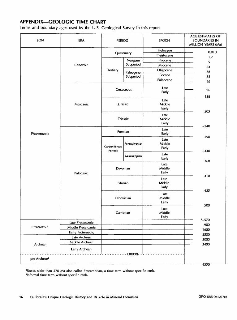
APPENDIX-GEOLOGIC TIME CHART Terms and boundary ages used by the U.S. Geological Survey in this report
EON ERA PERIOD EPOCH
Holocene Quaternary
Pleistocene
Neogene Pliocene
Cenozoic Subperiod Miocene
Tertiary Paleogene
Oligocene
Subperiod Eocene
Paleocene
Cretaceous Late Early
Late Mesozoic jurassic Middle
Early
Late Triassic Middle
Early
Permian Late
Phanerozoic Early
late Pennsylvanian Middle
Carboniferous Early Periods
Mississippian late Early
late Devonian Middle
Paleozoic Early
late Silurian Middle
Early
late Ordovician Middle
Early
late Cambrian Middle
Early
late Proterozoic Proterozoic Middle Proterozoic
Early Proterozoic
late Archean
Archean Middle Archean
Early Archean
- - - - - - - - - - - - - - - - - - - - - - - - - - - - - - - - - - - - - - - - - - (3800?)- - - - - - - - - - - - - - - - - -
16
pre-Archean2
1Rocks older than 570 Ma also called Precambrian, a time term without specific rank. 21nforrnal time term without specific rank.
California's Unique Geologic History and Its Role in Mineral Formation
AGE ESTIMATES OF BOUNDARIES IN
Ml LLION YEARS (Ma)
0.010 1.7 5
24 38 55 66
r--- 96
138
205
-240
290
-330
360
410
435
500
1-570 900
1600 2500 3000 3400
4550
GPO 685-041 /9781
SELECTED SERIES OF U.S. GEOLOGICAL SURVEY PUBLICATIONS
Periodicals
Earthquakes & Volcanoes (issued bimonthly). Preliminary Determination of Epicenters (issued monthly).
Technical Books and Reports
Professional Papers are mainly comprehensive scientific reports of wide and lasting interest and importance to professional scientists and engineers. Included are reports on the results of resource studies and of topographic, hydrologic, and geologic investigations. They also include collections of related papers addressing different aspects of a single scientific topic.
Bulletins contain significant data and interpretations that are of lasting scientific interest but are generally more limited in scope or geographic coverage than Professional Papers. They include the results of resource studies and of geologic and topographic investigations; as well as collections of short papers related to a specific topic.
Water-Supply Papers are comprehensive reports that present significant interpretive results of hydrologic investigations of wide interest to professional geologists, hydrologists, and engineers. The series covers investigations in all phases of hydrology, including hydrogeology, availability of water, quality of water, and use of water.
Cb'culars present administrative information or important scientific information of wide popular interest in a format designed for distribution at no cost to the public. Information is usually of short-term interest.
Water-Resources Investigations Reports are papers of an interpretive nature made available to the public outside the formal USGS publications series. Copies are reproduced on request unlike formal USGS publications, and they are also available for public inspection at depositories indicated in USGS catalogs.
Open-File Reports include unpublished manuscript reports, maps, and other material that are made available for public consultation at depositories. They are a nonpe:rmanent form of publication that may be cited in other publications as sources of information.
Maps
Geologic Quadrangle Maps are multicolor geologic maps on topographic bases in 7 1!2- or 15-minute quadrangle formats (scales mainly 1:24,000 or 1 :62,500) showing bedrock, surficial, or engineering geology. Maps generally include brief texts; some maps include structure and columnar sections only.
Geophysical Investigations Maps are on topographic or planimetric bases at various scales; they show results of surveys using geophysical techniques, such as gravity, magnetic, seismic, or radioactivity, which reflect subsurface structures that are of economic or geologic significance. Many maps include correlations with the geology.
Miscellaneous Investigations Series Maps are on planimetric or topographic bases of regular and irregular areas at various scales; they present a wide variety of format and subject matter. The series also includes 7 1/2-minute quadrangle photo geologic maps on planimetric bases which show geology as interpreted from aerial photographs. Series also includes maps of Mars and the Moon.
Coal Investigations Maps are geologic maps on topographic or planimetric bases at various scales showing bedrock or surficial geology, stratigraphy, and structural relations in certain coal-resource areas.
Oil and Gas Investigations Charts show stratigraphic information for certain oil and gas fields and other areas having petroleum potential.
Miscellaneous Field Studies Maps are multicolor or black-andwhite maps on topographic or planimetric bases on quadrangle or irregular areas at various scales. Pre-1971 maps show bedrock geology in relation to specific mining or mineral-deposit problems; post-1971 maps are primarily black-and-white maps on various subjects such as environmental studies or wilderness mineral investigations.
Hydrologic Investigations Atlases are multicolored or black-andwhite maps on topographic or planimetril- bases presenting a wide range of geohydrologic data of both regular and irregular areas; principal scale is 1:24,000 and regional studies are at 1:250,000 scale or smaller.
Catalogs
Permanent catalogs, as well as some others, giving comprehensive listings of U.S. Geological Survey publications are available under the conditions indicated below from the U.S. Geological Survey, Books and Open-File Reports Section, Federal Center, Box 25425, Denver, CO 80225. (See latest Price and Availability List.)
"Publications of the Geological Survey, 1879- 1961" may be purchased by mail and over the counter in paperback book form and as a set of microfiche.
"Publications of the Geological Survey, 1962- 1970" may be purchased by mail and over the counter in paperback book form and as a set of microfiche.
"Publications of the U.S. Geological Survey, 1971-1981" may be purchased by mail and over the counter in paperback book form (two volumes, publications listing and index) and as a set of microfiche.
Supplements for 1982, 1983, 1984, 1985,1986, and for subsequent years since the last permanent catalog may be purchased by mail and over the counter in paperback book form.
State catalogs, "List of U.S. Geological Survey Geologic and Water -Supply Reports and Maps For (State)," may be purchased by mail and over the counter in paperback booklet form only.
"Price and A vailabillty List of U.S. Geological Survey Publications," issued annually, is available free of charge in paperback booklet form only.
Selected copies of a monthly catalog "New Publications of the U.S. Geological Survey" available free of charge by mail or may be obtained over the counter in paperback booklet form only. Those wishing a free subscription to the monthly catalog "New Publications of the U.S. Geological Survey" should write to the U.S. Geological Survey, 582 National Center, Reston, VA 22092.
Note.--Prices of Government publications listed in older catalogs, announcements, and publications may be incorrect. Therefore, the prices charged may differ from the prices in catalogs, announcements, and publications.