Embed Size (px)
Citation preview

PŪLEHUNUI REGIONAL INFRASTRUCTURE MASTER PLAN Environmental Impact Statement Preparation Notice
Pūlehunui Ahupua‘a, Kula Moku, Maui
Prepared for:
Department of Hawaiian Home Lands
Department of Land and Natural Resources
Department of Accounting and General Services
Department of Public Safety
Proposing Agency:
Department of Hawaiian Home Lands
Prepared by:
Prepared pursuant to Chapter 343, Hawai‘i Revised Statutes, and
Chapter 11-200 Hawai‘i Administrative Rules
December 2017

[This page intentionally left blank.]
PŪLEHUNUI REGIONAL INFRASTRUCTURE MASTER PLAN
Environmental Impact Statement Preparation Notice
i
Table of Contents Summary ......................................................................................................................................... 1
1 Identification of the Proposing Agency ................................................................................... 9
2 Identification of the Accepting Authority ............................................................................... 9
3 Identification of Contact Person .............................................................................................. 9
4 Brief Description of Proposed Action ..................................................................................... 9
4.1 Purpose and Need ............................................................................................................ 9
4.2 Description of the Pūlehunui Regional Infrastructure Master Plan ............................... 10
5 Determination ........................................................................................................................ 12
5.1 Reasons Supporting the Determination ......................................................................... 15
6 Description of the Environment ............................................................................................ 16
7 Planning Horizon ................................................................................................................... 17
8 Alternatives ........................................................................................................................... 17
9 Affected Parties ..................................................................................................................... 22
List of Figures
Figure 1: Regional Location
Figure 2: Aerial Photograph
Figure 3: Tax Map Key
Figure 4: State Land Use District
Figure 5: DHHL Maui Island Plan Designations
Figure 6: Development Plan
Figure 7: Flood Insurance Rate Map
Figure 8: Wetlands and Surface Water
Figure 9: Land Study Bureau (LSB) and Agricultural Lands of Importance to the State of
Hawaii (ALISH) Classifications
Figure 10: USFWS Critical Habitat
PŪLEHUNUI REGIONAL INFRASTRUCTURE MASTER PLAN
Environmental Impact Statement Preparation Notice
ii
[This page intentionally left blank.]
PŪLEHUNUI REGIONAL INFRASTRUCTURE MASTER PLAN
Environmental Impact Statement Preparation Notice
1
SUMMARY
This Environmental Impact Statement Preparation Notice (EISPN) has been prepared in
accordance with Chapter 343, Hawai‘i Revised Statutes (HRS) for a regional infrastructure
master plan to serve certain State lands located along Maui Veterans Highway (former Mokulele
Highway), led by the State Department of Hawaiian Home Lands (DHHL), a State agency.
DHHL will undertake a regional infrastructure master planning effort on behalf of four State
agency stakeholders. DHHL anticipates that regional infrastructure improvements may be
beneficial to serve regional State-owned lands to be managed by DHHL, the State Department of
Land and Natural Resources (DLNR), or the State Department of Accounting and General
Services/Department of Public Safety (DAGS/PSD) and those agencies’ respective proposed
developments. Therefore a regional approach to infrastructure planning will facilitate
development at Pūlehunui in a manner that is financially and environmentally efficient,
maximizing the use of State funds while minimizing environmental impacts to the extent
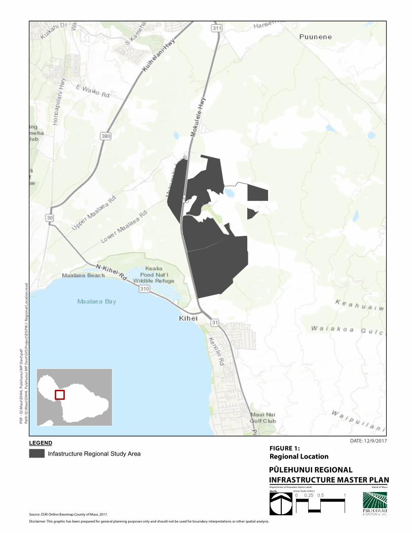
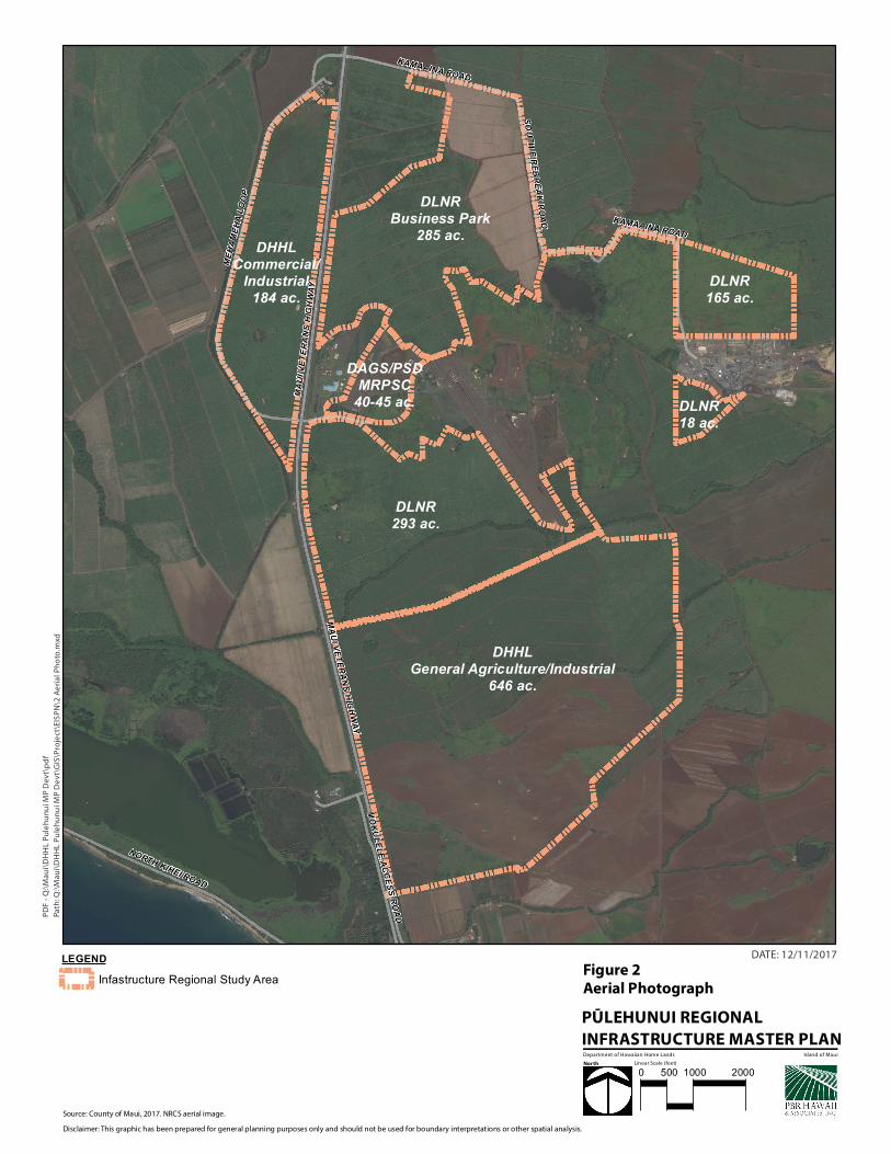
practicable. The proposed action is located in Pūlehunui, Maui, State of Hawai‘i. Figure 1 shows
the location of the proposed action; Figure 2 shows an aerial photograph of the region.
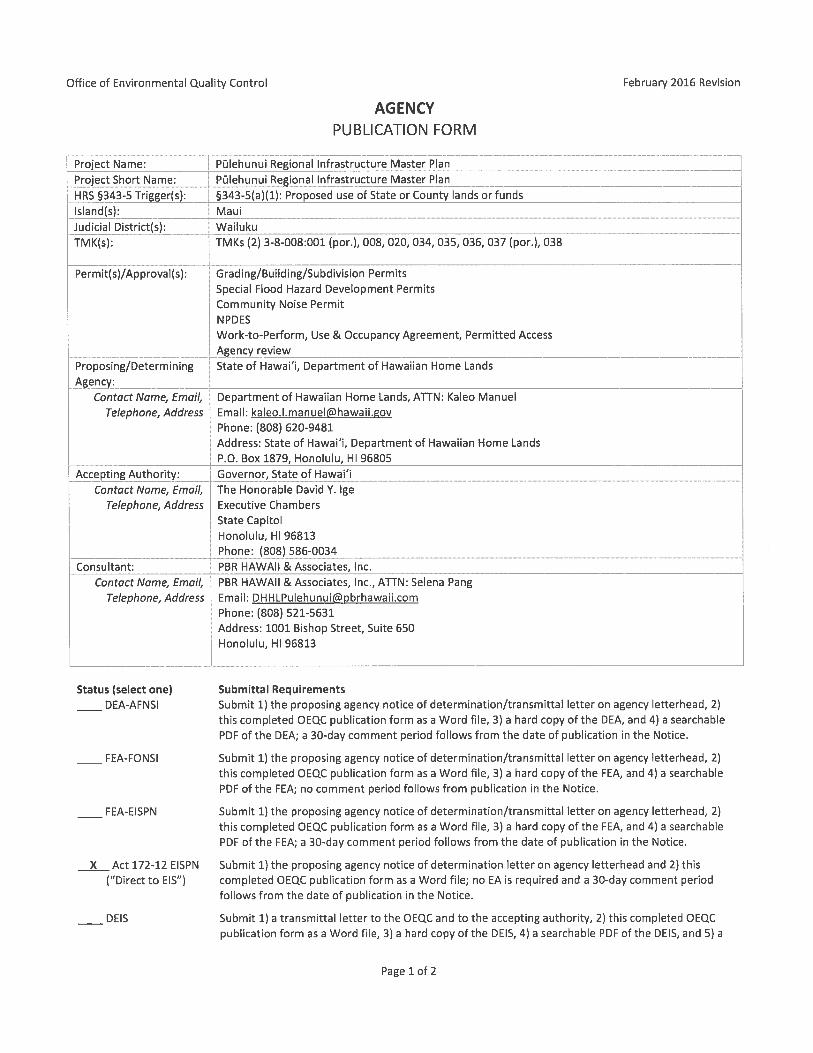
Name: Pūlehunui Regional Infrastructure Master Plan
Location: Pūlehunui Ahupua‘a, Kula Moku, Maui
Address: Maui Veterans Highway, Maui, HI (Figure 1)
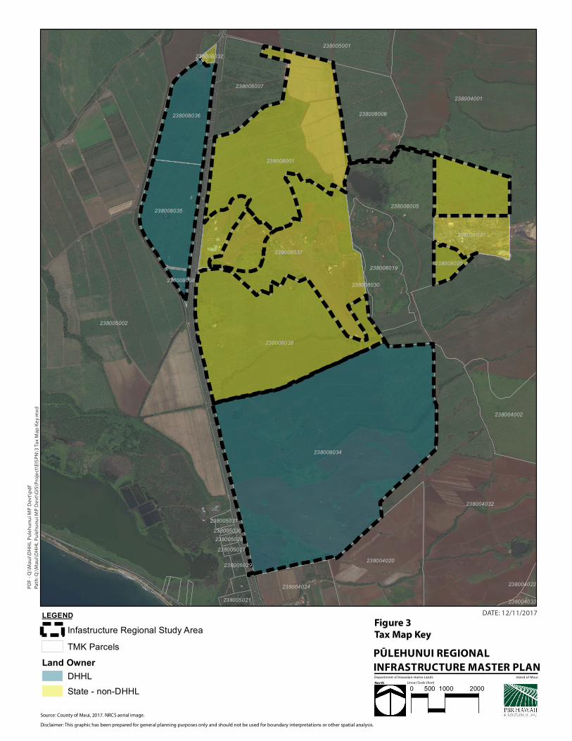
Tax Map Keys: TMK (2) 3-8-008:008, 035, and 036 (Pūlehunui North)
TMK (2) 3-8-008:034 (Pūlehunui South)
These parcels are owned and managed by DHHL, and are referred
to collectively as the “DHHL Project Areas”.
In addition to the DHHL Project Areas, the “Infrastructure
Regional Study Area” comprises other State-owned lands in the
region that are managed or anticipated to be managed by DLNR or
DAGS/PSD.
TMK (2) 3-8-008:001 (DLNR)
TMK (2) 3-8-008:020 (DLNR)
TMK (2) 3-8-008:037 por. (DAGS/PSD)
TMK (2) 3-8-008:038 (DLNR)
PŪLEHUNUI REGIONAL INFRASTRUCTURE MASTER PLAN
Environmental Impact Statement Preparation Notice
2
See Figure 2 for anticipated developments within the Infrastructure
Regional Study Area boundaries, and Figure 3, Tax Map Key.
Judicial District: Wailuku
Proposing Agency: State Department of Hawaiian Home Lands (DHHL)
Accepting Authority: Governor of the State of Hawai‘i
Recorded Fee Owner: DHHL Project Areas are owned by the State of Hawai‘i,
Department of Hawaiian Home Lands. Other lands within the
Infrastructure Regional Study Area State-owned lands to be
managed by DLNR or DAGS/PSD.
Existing Use: Vacant, generally unimproved
Proposed Action: DHHL will undertake a regional infrastructure master planning
effort on behalf of four State agency stakeholders involving a
coordinated regional infrastructure alternatives analysis for water,
wastewater, and key roadways. The regional analysis will evaluate
alternatives for regional, sub-regional, and “independent”
approaches to infrastructure development.
The land use programs on DHHL Project Areas are anticipated to
involve commercial/light industrial and agriculture-supporting
uses, and agricultural use by DHHL Beneficiaries. A portion of
Pūlehunui South may accommodate supporting regional
infrastructure, pending consultation and appropriate technical
studies.
Land Use
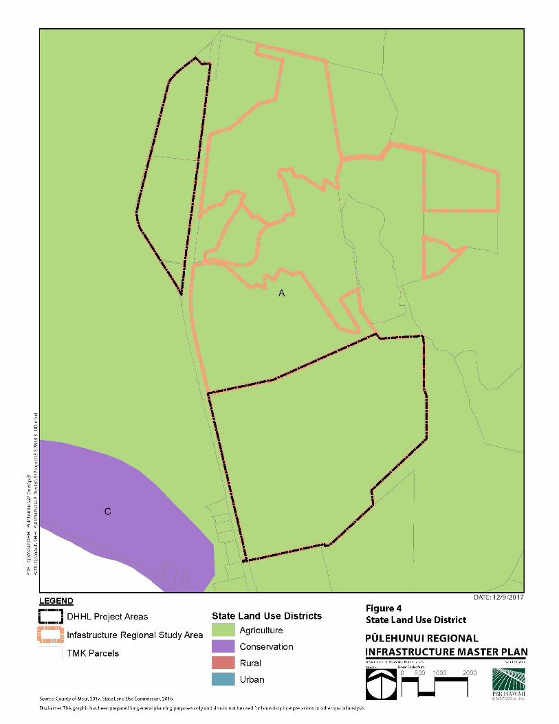
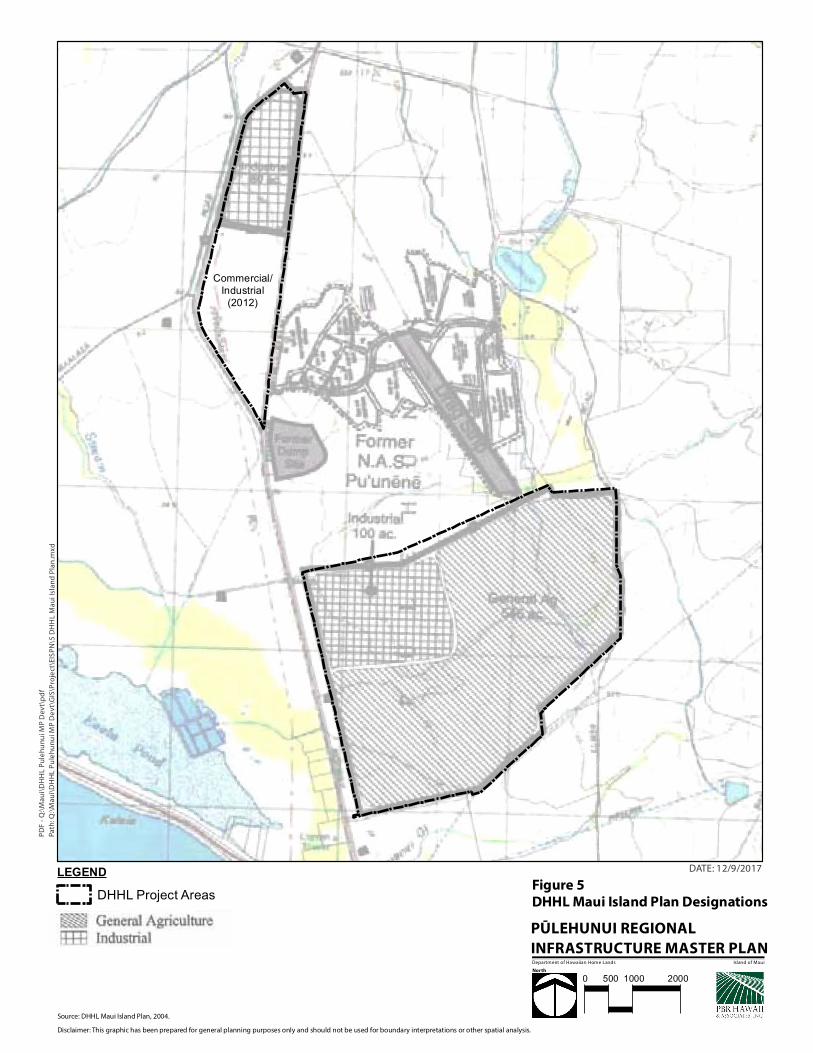
Designations: State Land Use: Agriculture (Figure 4)
Department of Hawaiian Home Lands: Industrial, General
Agriculture (Figure 5)
Special Management Area: Not within the SMA
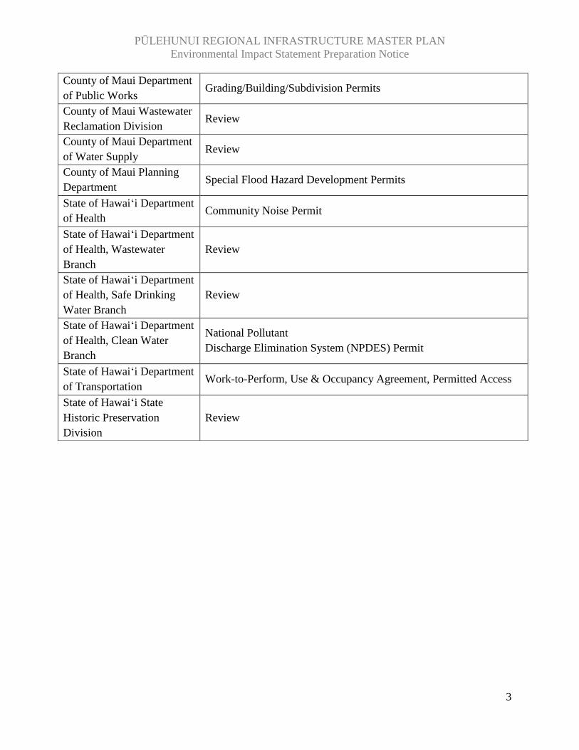
Major Reviews/Approvals Required:
Issuing Agency Permit/Approval
Governor, State of Hawai‘i Chapter 343, HRS Compliance
PŪLEHUNUI REGIONAL INFRASTRUCTURE MASTER PLAN
Environmental Impact Statement Preparation Notice
3
County of Maui Department
of Public Works Grading/Building/Subdivision Permits
County of Maui Wastewater
Reclamation Division Review
County of Maui Department
of Water Supply Review
County of Maui Planning
Department Special Flood Hazard Development Permits
State of Hawai‘i Department
of Health Community Noise Permit
State of Hawai‘i Department
of Health, Wastewater
Branch
Review
State of Hawai‘i Department
of Health, Safe Drinking
Water Branch
Review
State of Hawai‘i Department
of Health, Clean Water
Branch
National Pollutant
Discharge Elimination System (NPDES) Permit
State of Hawai‘i Department
of Transportation Work-to-Perform, Use & Occupancy Agreement, Permitted Access
State of Hawai‘i State
Historic Preservation
Division
Review
Path
: Q:\
Mau
i\D
HH
L P
ule
hu
nu
i MP
De
vt\G
IS\P
roje
ct\E
ISP
N\1
Reg
ion
al L
oca
tio
n.m
xd
PD
F -
Q:\
Mau
i\D
HH
L P
ule
hu
nu
i MP
Dev
t\p
df
DATE: 12/9/2017
Source: ESRI Online Basemap.County of Maui, 2017.
Disclaimer: This graphic has been prepared for general planning purposes only and should not be used for boundary interpretations or other spatial analysis.
Department of Hawaiian Home Lands
0 0.25 0.5 1 Linear Scale (miles)
LEGENDInfastructure Regional Study Area
Island of Maui
Path
: Q:\
Mau
i\D
HH
L P
ule
hu
nu
i MP
De
vt\G
IS\P
roje
ct\E
ISP
N\2
Ae
rial
Ph
oto
.mxd
DATE: 12/11/2017
Source: County of Maui, 2017. NRCS aerial image.
Disclaimer: This graphic has been prepared for general planning purposes only and should not be used for boundary interpretations or other spatial analysis.
Department of Hawaiian Home Lands
MEHA
MEHA
LOOP
MAUI
VETE
RANS
HIG
HWAY
NORTH KIHEI ROAD
KAMAAINA ROAD
MOKULELE ACCESS ROAD
SOUTH FIREBREAK ROAD
MAUI VETERANS HIGHWAY
KAMAAINA ROAD
LEGENDInfastructure Regional Study Area
0 500 1000 2000Linear Scale (feet)
PD
F -
Q:\
Mau
i\D
HH
L P
ule
hu
nu
i MP
Dev
t\p
df
Island of Maui
DHHLCommercial/
Industrial184 ac.
DLNRBusiness Park
285 ac.
DAGS/PSDMRPSC
40-45 ac.
DHHLGeneral Agriculture/Industrial
646 ac.
DLNR293 ac.
DLNR165 ac.
DLNR18 ac.
238005002
238008034
238004001
238004032
238008001
238008038
238008037
238008005
238004020
238008006
238008035
238008007
238008019
238005001
238008036
238004002
238004024
238008031
238008020
238005021
238008008
238004033
238004022
238005029
238005031
238008030
238005027238005028
238008032
238005030
Path
: Q:\
Mau
i\D
HH
L P
ule
hu
nu
i MP
De
vt\G
IS\P
roje
ct\E
ISP
N\3
Tax
Map
Ke
y.m
xd
DATE: 12/11/2017
Source: County of Maui, 2017. NRCS aerial image.
Disclaimer: This graphic has been prepared for general planning purposes only and should not be used for boundary interpretations or other spatial analysis.
Department of Hawaiian Home Lands
0 500 1000 2000Linear Scale (feet)
PD
F -
Q:\
Mau
i\D
HH
L P
ule
hu
nu
i MP
Dev
t\p
df
LEGENDInfastructure Regional Study AreaTMK Parcels
Land OwnerDHHLState - non-DHHL
Island of Maui
Path
: Q:\
Mau
i\D
HH
L P
ule
hu
nu
i MP
De
vt\G
IS\P
roje
ct\E
ISP
N\5
DH
HL
Mau
i Isl
and
Pla
n.m
xd
PD
F -
Q:\
Mau
i\D
HH
L P
ule
hu
nu
i MP
Dev
t\p
df
DATE: 12/9/2017
Disclaimer: This graphic has been prepared for general planning purposes only and should not be used for boundary interpretations or other spatial analysis.
Department of Hawaiian Home Lands Island of Maui
LEGENDDHHL Project Areas
Source: DHHL Maui Island Plan, 2004.
0 500 1000 2000
Commercial/Industrial
(2012)
PŪLEHUNUI REGIONAL INFRASTRUCTURE MASTER PLAN
Environmental Impact Statement Preparation Notice
9
1 IDENTIFICATION OF THE PROPOSING AGENCY
The State of Hawai‘i, Department of Hawaiian Home Lands is the Proposing Agency.
Contact: Kaleo Manuel, Acting Planning Program Manager
Planning Office
State of Hawai‘i, Department of Hawaiian Home Lands
P.O. Box 1879, Honolulu, HI 96805
Phone: (808) 620-9481 / FAX: (808) 620-9559
Email: [email protected]
2 IDENTIFICATION OF THE ACCEPTING AUTHORITY
The Governor of the State of Hawai‘i is the Accepting Authority.
Contact: The Honorable David Y. Ige
Governor, State of Hawai‘i
Executive Chambers
State Capitol
Honolulu, HI 96813
Phone: (808) 586-0034 / FAX: (808) 586-0006
3 IDENTIFICATION OF CONTACT PERSON
The environmental consultant is PBR HAWAII & Associates, Inc.
Contact: Selena Pang, Planner
PBR HAWAII
1001 Bishop Street, Suite 650
Honolulu, HI 96813
Phone: (808) 521-5631
Fax: (808) 523-1402
Email: [email protected]
4 BRIEF DESCRIPTION OF PROPOSED ACTION
4.1 Purpose and Need
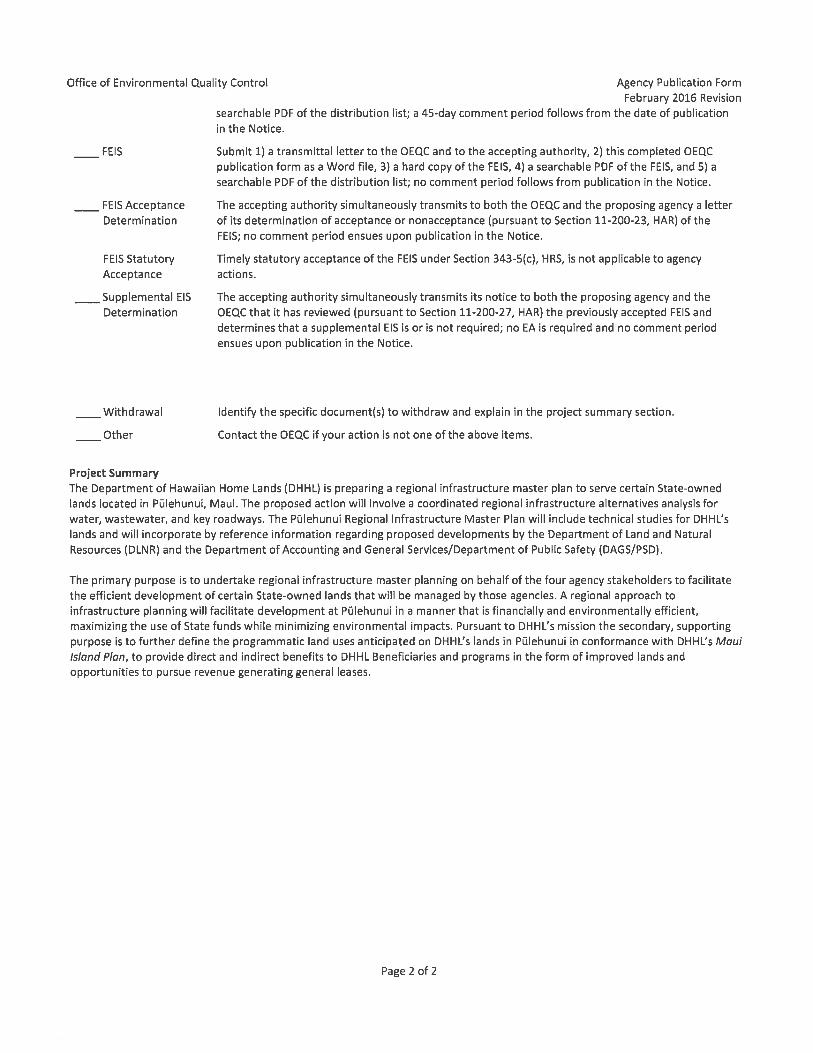
The primary purpose of the Pūlehunui Regional Infrastructure Master Plan is to undertake
regional infrastructure master planning on behalf of DHHL, Department of Land and Natural
Resources (DLNR) and Department of Accounting and General Services/Department of Public
PŪLEHUNUI REGIONAL INFRASTRUCTURE MASTER PLAN
Environmental Impact Statement Preparation Notice
10
Safety (DAGS/PSD), to facilitate the efficient development of certain State-owned lands in
Pūlehunui, Central Maui that will be managed by those agencies. DHHL anticipates that regional
infrastructure improvements may be beneficial to serve regional lands managed by said agencies
and those agencies’ respective proposed developments. Therefore a regional approach to
infrastructure planning will facilitate development at Pūlehunui in a manner that is financially
and environmentally efficient, maximizing the use of State funds while minimizing
environmental impacts to the extent practicable. Figure 1 shows the location of the proposed
action; Figure 2 shows an aerial photograph of the Infrastructure Regional Study Area. Figure 3,
Tax Map Key, shows land ownership within the Infrastructure Regional Study Area and
surrounding lands.
Pursuant to DHHL’s mission the secondary, supporting purpose of the proposed action is to
further define the programmatic land uses anticipated on DHHL’s lands in Pūlehunui (DHHL
Project Areas), through the Beneficiary Consultation process and technical studies and in
conformance with the Maui Island Plan (Department of Hawaiian Home Lands, 2004), to
provide direct and indirect benefits to DHHL Beneficiaries and programs in the form of
improved lands and opportunities to pursue revenue generating general leases at Pūlehunui
North.
4.2 Description of the Pūlehunui Regional Infrastructure Master Plan
Regional infrastructure study. DHHL will undertake a regional infrastructure master planning
effort on behalf of four State agency stakeholders. The proposed action will involve a
coordinated regional infrastructure alternatives analysis for water, wastewater, and key
roadways. The regional analysis will evaluate alternatives for regional, sub-regional, and
“independent” approaches to infrastructure development.
The Pūlehunui Regional Infrastructure Master Plan will include technical studies for DHHL’s
lands at Pūlehunui (land use programs for which are described below) and will incorporate by
reference other project information provided by DLNR and DAGS/PSD for their respective
proposed developments. The regional planning effort will be carried out in a manner consistent
with the 2014 MOU between DHHL, DLNR, DAGS, and PSD, wherein these parties agreed to
“make their best efforts to work in a collaborative manner”. The MOU was intended to allow the
aforementioned agencies to benefit from economies of scale, joint infrastructure financing,
planning and development, and provide significant economic benefits to the Maui community. In
2014, $4M of Capital Improvement Funds were awarded to DHHL for infrastructure planning
and design pursuant to the MOU (Act 122, Session Laws of Hawai‘i 2014).
DHHL is underway with preliminary engineering assessments to analyze regional alternative
approaches to water, wastewater, and traffic, in tandem with any related refinements to land use
programs in DHHL Project Areas. These processes will be informed by the completion of
PŪLEHUNUI REGIONAL INFRASTRUCTURE MASTER PLAN
Environmental Impact Statement Preparation Notice
11
additional technical studies, continued coordination with MOU parties, consultation with the
DHHL Beneficiary Community, and comments received during the EISPN and EIS public
comment periods.
Development of DHHL Lands and Compatibility with DHHL Maui Island Plan.
Land use programs in DHHL Project Areas will inform the regional infrastructure analysis which
will also incorporate by reference other project information provided by DLNR and DAGS/PSD
for their respective proposed developments.
The Hawaiian Homes Commission Act (§§204 and 206) vests DHHL with exclusive authority to
control its lands, which means the DHHL Project Areas are not subject to State or County land
use controls. Instead, DHHL established a planning system that includes a General Plan, Island
Plans, Program Plans, Regional Plans, Special Plans and various implementing mechanisms. The
Island Plans identify DHHL’s land use designations, which are DHHL’s equivalent to zoning.
The Pūlehunui Regional Infrastructure Master Plan is consistent with DHHL’s Maui Island
Plan1. DHHL’s Island Plans are island-specific, 20-year visioning documents that designate land
uses for DHHL-owned property. In 2004, DHHL adopted the (DHHL) Maui Island Plan which
examined all DHHL land in terms of development constraints and opportunities and other
criteria, to assign appropriate Land Use Designations to each parcel.
The Maui Island Plan designates Pūlehunui South primarily for General Agriculture use with
approximately 100 acres designated for Industrial use (Department of Hawaiian Home Lands,
2004).
At Pūlehunui North, the Maui Island Plan designates Parcel 36 for Industrial use. The adjacent
Parcels 8 and 35 were acquired subsequent to the Maui Island Plan, and the Maui Island Plan
was amended to designate Commercial and Industrial uses on those parcels.
DHHL land use programs are anticipated to involve commercial/light industrial and agriculture-
supporting uses, and agricultural use by DHHL Beneficiaries. A portion of Pūlehunui South may
accommodate supporting regional infrastructure, pending consultation and appropriate technical
studies. A more detailed description of the anticipated land uses is provided below. Due to
infrastructure requirements and site constraints, DHHL anticipates that land uses at Pūlehunui
South may not be sited exactly as shown in the Maui Island Plan; siting of land uses at this
property will be further informed throughout the planning process, based on stakeholder
consultation and technical studies.
1 The Maui Island Plan is available for view on the DHHL website: https://dhhl.hawaii.gov/wp-
content/uploads/2012/05/Island_Plan_Maui_2004.pdf
PŪLEHUNUI REGIONAL INFRASTRUCTURE MASTER PLAN
Environmental Impact Statement Preparation Notice
12
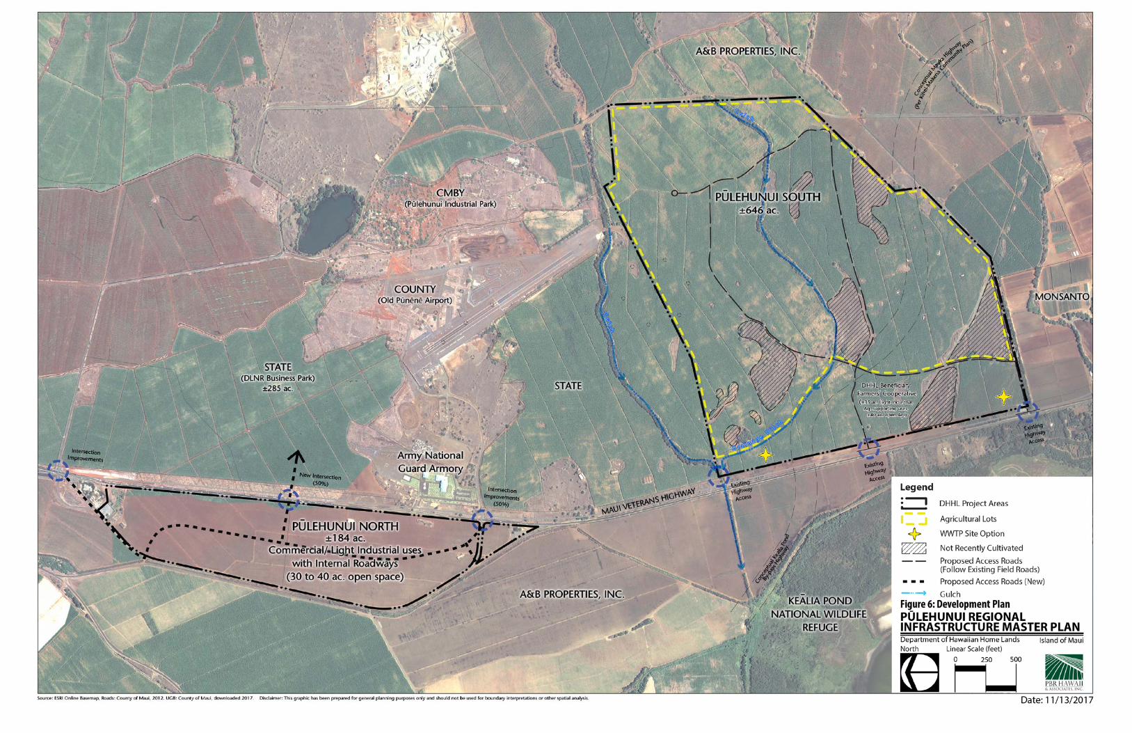
See Figure 6, Draft Development Plan, for a conceptual development plan for the DHHL Project
Areas, consistent with the Maui Island Plan.
Commercial/Industrial Uses – Commercial/light industrial use is anticipated to occupy up to
140 acres at Pūlehunui North, and approximately 35 acres at Pūlehunui South.
Commercial/industrial use provides for the most flexible use of the DHHL Project Areas and
could support retail, agribusiness processing, packaging, and/or marketing of agricultural goods
produced at Pūlehunui South and throughout Central Maui. Light industrial-zoned lots on other
Maui properties accommodate retail uses. Large, contiguous commercial lots would be suitable
for a more comprehensive commercial or retail complex and/or a visitor attraction destination,
cultural center or other large visitor industry-based use.
In addition to revenue generation to support DHHL activities, DHHL proposes to provide areas
devoted to use by smaller businesses including those of DHHL Beneficiaries, to support
Beneficiary economic development initiatives. Activities in this area will build capacity in the
small business community by providing a space for individual businesses or Beneficiary
individuals or organizations to produce and sell products and services in a highly-visible and
central location.
Open Space and Agricultural Uses - Between roughly 30 and 40 acres of open space have been
assumed in the development plan to meet drainage needs at Pūlehunui North. The majority of
Pūlehunui South will be used for agriculture, with some of its open space supporting agricultural
crops selected to avoid impacting visual resources or business visibility.
5 DETERMINATION
Section 343-5 (e), HRS (enacted by Act 172 (2012)) allows an applicant to prepare an EIS rather
than an environmental assessment if the Accepting Authority determines, through its judgment
and experience, that an EIS is likely to be required. The preparation of such an EIS begins with
the preparation of an EISPN, sometimes referred to as an “Act 172 EISPN.” Under the
provisions of §343-5 (b), HRS DHHL has determined, through its judgment and experience, that
an Environmental Impact Statement (EIS) is likely to be required for the Pūlehunui Regional
Infrastructure Master Plan.
Preparation of an EIS is being undertaken to address requirements of Chapter 343, HRS and Title
11, Department of Health, Chapter 200, Environmental Impact Rules, Hawai‘i Administrative
Rules Section 343-5, HRS established nine “triggers” that require either an Environmental
Assessment (EA) or an EIS. The Pūlehunui Regional Infrastructure Master Plan is an agency
action funded by Capital Improvement Funds earmarked for interagency infrastructure planning;

PŪLEHUNUI REGIONAL INFRASTRUCTURE MASTER PLAN
Environmental Impact Statement Preparation Notice
15
the use of State or County lands or funds is one quality that “triggers” the preparation of an EA
or EIS.
5.1 Reasons Supporting the Determination
Based on a review of the significance criteria set forth under Section 11-200-12(b), HAR it is
anticipated that the Pūlehunui Regional Infrastructure Master Plan may have a significant effect
on the environment due to one or more of the significance criteria which are:
1. Involves an irrevocable commitment to loss or destruction of any natural or cultural
resource;
2. Curtails the range of beneficial uses of the environment;
3. Conflicts with the state’s long‐term environmental policies or goals and guidelines as
expressed in Chapter 344, HRS, and any revisions thereof and amendments there to, court
decisions, or executive orders;
4. Substantially affects the economic welfare, social welfare, and cultural practices of the
community or State;
5. Substantially affects public health;
6. Involves secondary impacts, such as population changes or effects on public facilities;
7. Involves a substantial degradation of environmental quality;
8. Is individually limited but cumulatively has a considerable effect upon the environment
or involves a commitment for larger actions;
9. Substantially affects a rare, threatened, or endangered species, or its habitat;
10. Detrimentally affect air or water quality or ambient noise levels;
11. Affects, or is likely to suffer damage by being located in an environmentally sensitive
area such as a flood plain, tsunami zone, beach, erosion‐prone area, geologically
hazardous land, estuary, fresh water or coastal waters;
12. Substantially affects scenic vistas and view planes identified in county or state plans or
studies; and
13. Requires substantial energy consumption.
Based on the above criteria, DHHL does not anticipate that it could be affirmatively concluded
that the Pūlehunui Regional Infrastructure Master Plan would not have a significant effect on the
environment. In particular, regional infrastructure and/or DHHL land use programs are
potentially anticipated to involve secondary impacts on public facilities such as roads, are
potentially anticipated to substantially affect visual resources along Maui Veterans Highway, and
are potentially anticipated to require substantial energy consumption.
The Draft EIS will include a full assessment of anticipated impacts and proposed mitigation
measures to minimize anticipated adverse impacts. DHHL does not anticipate that an EA
prepared to assess the anticipated impacts would warrant a Finding of No Significant Impact
PŪLEHUNUI REGIONAL INFRASTRUCTURE MASTER PLAN
Environmental Impact Statement Preparation Notice
16
(FONSI) in light of the significance criteria under Section 11-200-12(b). Therefore DHHL
believes that the Pūlehunui Regional Infrastructure Master Plan is likely to require a full
environmental review through the completion of an EIS and therefore the environmental review
should proceed directly to the preparation of an EIS through this EISPN. As Accepting
Authority, the Governor of the State of Hawai‘i has the authority to determine that an EIS is
likely to be required, and therefore to authorize DHHL to initiate its environmental review
through the preparation of an EISPN.
6 DESCRIPTION OF THE ENVIRONMENT
This description includes only DHHL Project Areas. The Pūlehunui Regional Infrastructure
Master Plan Draft EIS will incorporate by reference other project information provided by
DLNR and DAGS/PSD for their respective proposed developments.
The DHHL Project Areas are located on both sides of Maui Veterans Highway, near the
Pu‘unēnē Armory. See Figure 1 and Figure 2. The DHHL Project Areas consist of four parcels:
TMK (2) 3-8-008-008, 034, 035, and 036. The total land area of DHHL Project Areas is 830.359
acres. See Figure 3, Tax Map Key, for the Infrastructure Regional Study Area in the context of
surrounding lands.
Tax Map Key (TMK)
Acres
(2) 3-8-008-008
6.926 acres
(2) 3-8-008-034 646.000 acres
(2) 3-8-008-035
97.433 acres
(2) 3-8-008-036
80.000 acres
The DHHL Project Areas are vacant and were formerly leased to Alexander & Baldwin (A&B)
for sugarcane cultivation. When A&B transitioned out of sugarcane in 2016, the lease was not
renewed. Prior to sugar cultivation, much of the region was occupied by the Naval Air Station
Pu‘unēnē.
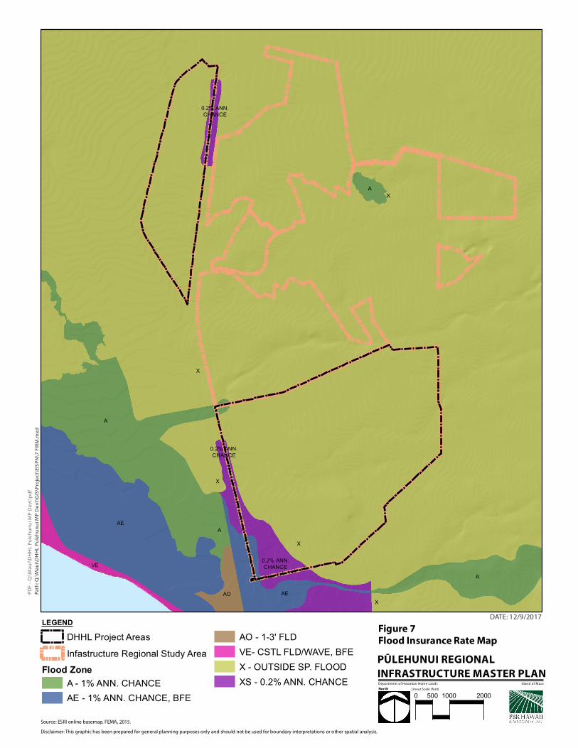
The DHHL Project Areas are primarily located in Flood Zone X (outside the 500-year flood
zone). Portions of the Pūlehunui North and Pūlehunui South are designated Zone XS (within the
500-year or 0.2% annual chance floodplain, within the 1% annual chance floodplain with
average depths of less than 1 foot or with drainage areas less than 1 square mile and areas
protected from the 1% annual chance flood by levee) or AE (within the 100-year floodplain, with
Base Flood Elevations determined) (Figure 7).
PŪLEHUNUI REGIONAL INFRASTRUCTURE MASTER PLAN
Environmental Impact Statement Preparation Notice
17
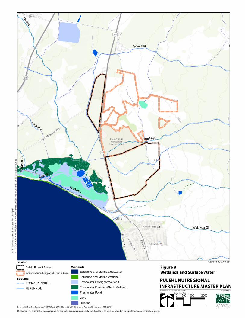
Only Pūlehunui South includes an unnamed non-perennial stream. There are no streams or
surface water bodies within Pūlehunui North. The drainage ditch from Pūlehu Gulch, which is
considered a non-perennial stream, runs along a portion of Mehameha Loop on Alexander &
Baldwin lands (Figure 8). The Draft EIS will include an assessment of drainage and will address
any anticipated impacts to wetlands and surface water resources.
The DHHL Project Areas have a Land Study Bureau (LSB) overall productivity rating of E, the
lowest (poorest) agricultural productivity rating (Figure 9). The LSB rating system is based on
critical agricultural factors including soil texture, structure, depth, drainage, parent material,
stoniness, topography, climate and rainfall. Much of the property has an Agricultural Lands of
Importance to the State of Hawai‘i (ALISH) rating of Prime ALISH, suggesting that the property
is prime farmland. However, the “Prime” designation has often been given to cultivated tracts of
land, and the property was cultivated during ALISH designation. Land use history may therefore
be the underlying reason for the discrepancy between the LSB and ALISH classifications.
The property is not located within or adjacent to critical habitat designated by the US Fish and
Wildlife Service, or endangered or threatened species habitat (Figure 10). The Draft EIS will
include a biological report.
The Draft EIS will contain a full description of the environment of the DHHL Project Areas as
supported by technical studies, an in-depth review of other relevant project information provided
by DLNR and DAGS/PSD for their respective proposed developments within the Infrastructural
Regional Study Area, and a discussion of potential impacts and mitigation measures.
7 PLANNING HORIZON
The planning horizon for the of the Pūlehunui Regional Infrastructure Master Plan is long-term.
The planning process is anticipated to include consultation with DHHL Beneficiaries as well as
the surrounding community. The forthcoming EIS is anticipated to take one to two years.
8 ALTERNATIVES
The Draft EIS will include a detailed discussion of alternative land uses, as well as possible
options for providing infrastructure (water, sewer, drainage and roads) to support anticipated
land uses.
Path
: Q:\
Mau
i\D
HH
L P
ule
hu
nu
i MP
De
vt\G
IS\P
roje
ct\E
ISP
N\7
FIR
M.m
xd
PD
F -
Q:\
Mau
i\D
HH
L P
ule
hu
nu
i MP
Dev
t\p
df
DATE: 12/9/2017
Source: ESRI online basemap. FEMA, 2015.
Disclaimer: This graphic has been prepared for general planning purposes only and should not be used for boundary interpretations or other spatial analysis.
Department of Hawaiian Home Lands
0.2% ANN.CHANCE
0.2% ANN.CHANCE
0.2% ANN.CHANCE
X
AO
A
X
AE
AE
A
VE
A
X
A
X
X
Linear Scale (feet)
LEGENDDHHL Project AreasInfastructure Regional Study Area
Flood ZoneA - 1% ANN. CHANCEAE - 1% ANN. CHANCE, BFE
AO - 1-3' FLDVE- CSTL FLD/WAVE, BFEX - OUTSIDE SP. FLOODXS - 0.2% ANN. CHANCE Island of Maui
0 500 1000 2000
Path
: Q:\
Mau
i\D
HH
L P
ule
hu
nu
i MP
De
vt\G
IS\P
roje
ct\E
ISP
N\8
Wet
lan
ds
and
Su
rfac
e W
ater
.mxd
PD
F -
Q:\
Mau
i\D
HH
L P
ule
hu
nu
i MP
Dev
t\p
df
DATE: 12/9/2017
Source: ESRI online basemap.NWI/USFWS, 2016. Hawaii DLNR Division of Aquatic Resources, 2008, 2013.
Disclaimer: This graphic has been prepared for general planning purposes only and should not be used for boundary interpretations or other spatial analysis.
Department of Hawaiian Home Lands
Waikapu
Waiakoa Gl
Poha
kea G
l
Waikapu
Waikapu
Waikapu
Waikapu
Waikapu
Linear Scale (feet)
LEGENDDHHL Project AreasInfastructure Regional Study Area
StreamsNON-PERENNIALPERENNIAL
WetlandsEstuarine and Marine DeepwaterEstuarine and Marine WetlandFreshwater Emergent WetlandFreshwater Forested/Shrub WetlandFreshwater PondLakeRiverine
Island of Maui
0 500 1000 2000
Path
: Q:\
Mau
i\D
HH
L P
ule
hu
nu
i MP
De
vt\G
IS\P
roje
ct\E
ISP
N\9
LS
B.m
xd
PD
F -
Q:\
Mau
i\D
HH
L P
ule
hu
nu
MP
De
vti\
pd
f
DATE: 12/9/2017
Source: ESRI online basemap. LSB: State Land Use Commission, 2012. ALISH: State OP digitized from Hawaii Department of Agriculture, 1977.
Disclaimer: This graphic has been prepared for general planning purposes only and should not be used for boundary interpretations or other spatial analysis.
Department of Hawaiian Home Lands
Linear Scale (feet)
LEGENDDHHL Project AreasTMK parcelsInfrastructure Regional Study Area
Ag. Lands of Importance to the State of HawaiiPrime ALISHOther ALISHUnclassified
LSB Productivity RatingABCDE
Island of Maui
0 500 1000 2000
PŪLEHUNUI REGIONAL INFRASTRUCTURE MASTER PLAN
Environmental Impact Statement Preparation Notice
22
9 AFFECTED PARTIES
Community engagement and Beneficiary Consultation are important elements of the Department
of Hawaiian Home Lands planning process. To prepare a fully acceptable EIS, DHHL will
consult all appropriate agencies and other citizen groups, and concerned individuals. Notification
of the availability of the EIS Preparation Notice for review and comment will be provided to
potentially affected agencies, as well as interested community members, organizations,
businesses, and surrounding landowners.
The Draft EIS is expected to be published on the State of Hawai‘i Department of Health, Office
of Environmental Quality Control’s website. Notification of the availability of the Draft EIS for
review and comment will be provided to potentially affected agencies, as well as interested
community members, organizations, businesses, and surrounding landowners.

![FILE COPY - oeqc2.doh.hawaii.govoeqc2.doh.hawaii.gov/EA_EIS_Library/2018-03-23-OA-FEA-Waialua... · Tax Map Key: [1] 6-7-001: ... Review, Special Management Area Use Permit, Building,](https://img.pdfslide.net/doc/110x75/5b38634d7f8b9a310e8d395d/file-copy-oeqc2doh-tax-map-key-1-6-7-001-review-special-management.jpg)


![DAVIDY . IGE DR CHRISTINA M K ISH MOTO GOVERNOR …oeqc2.doh.hawaii.gov/EA_EIS_Library/2018-01-23-OA-DEA-Lanikai... · Oahu i Koolaupoko i [1] ... Review, Special Management Area](https://img.pdfslide.net/doc/110x75/5b38634d7f8b9a310e8d3963/davidy-ige-dr-christina-m-k-ish-moto-governor-oeqc2doh-oahu-i-koolaupoko.jpg)