Embed Size (px)
Citation preview

DEPARTMENT OF NATURAL RESOURCESDIVISION OF GEOLOGICAL SURVEY
Lawrence H. Wickstrom, Chief
Open-File Report 2011-1
Central Ohio’s Geology in Coreand Outcrop Workshop II
Hosted byOhio Department of Natural Resources
Division of Geological Survey
Sponsored byOhio Geological Society
Horace R. Collins LaboratoryDelaware, OhioApril 20, 2011
Ohio Department of Natural ResourcesDivision of Geological Survey2045 Morse Road, Bldg. C-1Columbus, Ohio 43229-6693
2011
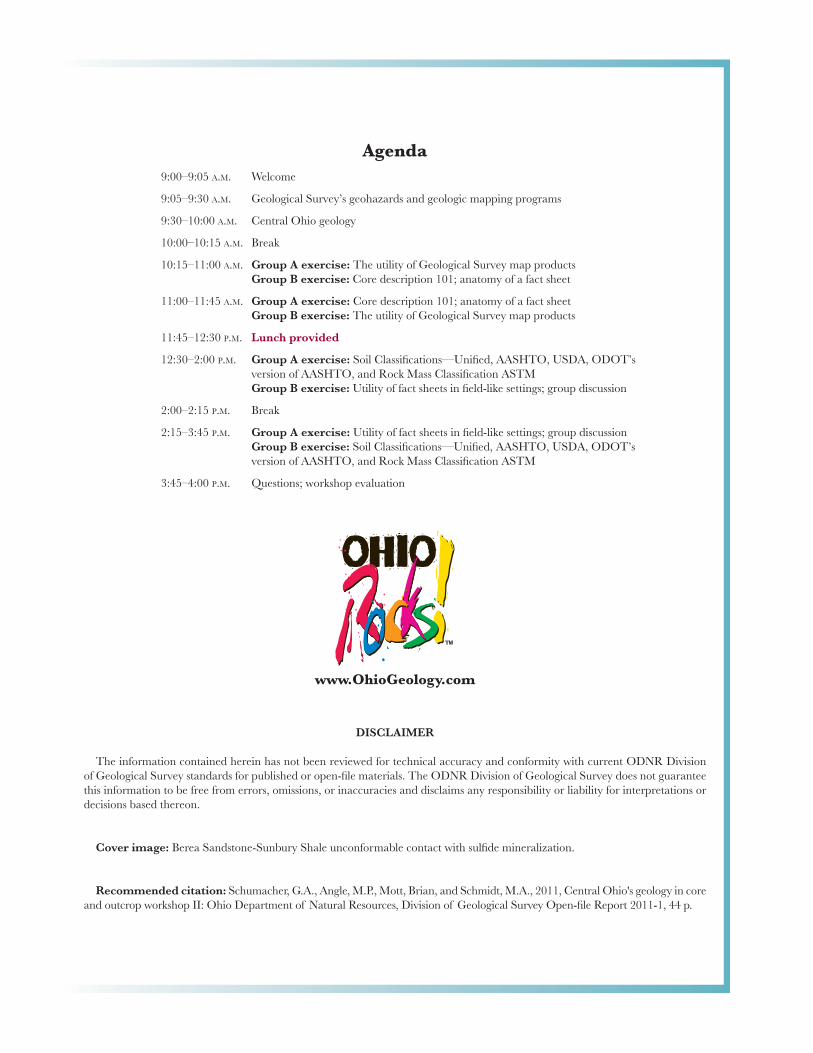
Agenda9:00–9:05 A.M. Welcome
9:05–9:30 A.M. Geological Survey’s geohazards and geologic mapping programs
9:30–10:00 A.M. Central Ohio geology
10:00–10:15 A.M. Break
10:15–11:00 A.M. Group A exercise: The utility of Geological Survey map products Group B exercise: Core description 101; anatomy of a fact sheet
11:00–11:45 A.M. Group A exercise: Core description 101; anatomy of a fact sheet Group B exercise: The utility of Geological Survey map products
11:45–12:30 P.M. Lunch provided
12:30–2:00 P.M. Group A exercise: Soil Classifi cations—Unifi ed, AASHTO, USDA, ODOT’s version of AASHTO, and Rock Mass Classifi cation ASTM
Group B exercise: Utility of fact sheets in fi eld-like settings; group discussion
2:00–2:15 P.M. Break
2:15–3:45 P.M. Group A exercise: Utility of fact sheets in fi eld-like settings; group discussion Group B exercise: Soil Classifi cations—Unifi ed, AASHTO, USDA, ODOT’s
version of AASHTO, and Rock Mass Classifi cation ASTM
3:45–4:00 P.M. Questions; workshop evaluation
DISCLAIMER
The information contained herein has not been reviewed for technical accuracy and conformity with current ODNR Division of Geological Survey standards for published or open-fi le materials. The ODNR Division of Geological Survey does not guarantee this information to be free from errors, omissions, or inaccuracies and disclaims any responsibility or liability for interpretations or decisions based thereon.
Cover image: Berea Sandstone-Sunbury Shale unconformable contact with sulfi de mineralization.
Recommended citation: Schumacher, G.A., Angle, M.P., Mott, Brian, and Schmidt, M.A., 2011, Central Ohio's geology in core and outcrop workshop II: Ohio Department of Natural Resources, Division of Geological Survey Open-fi le Report 2011-1, 44 p.
www.OhioGeology.com

Speakers
Co-Coordinators
Brian MottDLZ Ohio
6121 Huntley RoadColumbus, OH 43229
(614) [email protected]
Mort SchmidtCox-Colvin & Associates, Inc.
7750 Corporate Blvd.Plain City, OH 43064
(614) [email protected]
Mike AngleOhio Department of Natural Resources
Division of Geological Survey2045 Morse Road, Bldg. C-2Columbus, OH 43229-6693
(614) [email protected]
Greg SchumacherOhio Department of Natural Resources
Division of Geological SurveyH. R. Collins Laboratory
3307 South Old State RoadDelaware, OH 43015
(740) [email protected]
Division of Geological SurveyGeohazards and Geologic
Mapping Programs
Mike AngleSupervisor, Geologic Mapping Group
Ohio Department of Natural ResourcesDivision of Geological Survey2045 Morse Road, Bldg. C-2Columbus, OH 43229-6693
(614) [email protected]
Introduction toCentral Ohio Geology
Mac SwinfordAssistant Chief
Ohio Department of Natural ResourcesDivision of Geological Survey2045 Morse Road, Bldg. C-1Columbus, OH 43229-6693
(614) [email protected]
Mac SwinfordOhio Department of Natural Resources
Division of Geological Survey2045 Morse Road, Bldg. C-1Columbus, OH 43229-6693
(614) [email protected]

Contents
Ohio Department of Transportation soil and rock classifi cation .................................................................. 1 Quick reference for visual description of soils ....................................................................................... 1 Quick reference guide for rock description ............................................................................................ 3 Rock type ............................................................................................................................................... 5 Rock core photo examples ..................................................................................................................... 8Fact sheet source material .............................................................................................................................. 10Geologic time scale ........................................................................................................................................ 11Glacial sand-and-gravel deposits .................................................................................................................... 12Glacial lacustrine deposits .............................................................................................................................. 14Glacial till ....................................................................................................................................................... 16Cuyahoga Formation ..................................................................................................................................... 18Sunbury Shale ................................................................................................................................................ 20Berea Sandstone ............................................................................................................................................. 22Bedford Shale ................................................................................................................................................. 24Ohio Shale ..................................................................................................................................................... 26Olentangy Shale ............................................................................................................................................. 28Delaware Limestone ...................................................................................................................................... 30Columbus Limestone ..................................................................................................................................... 32
Maps
Bedrock Geologic Map of Ohio .................................................................................................................... 34Glacial Map of Ohio ..................................................................................................................................... 36Shaded Bedrock-Topography Map of Ohio .................................................................................................. 38Known and Probable Karst in Ohio ............................................................................................................. 40Shaded Drift-Thickness Map of Ohio ........................................................................................................... 42
1CENTRAL OHIO’S GEOLOGY IN CORE AND OUTCROP WORKSHOP II
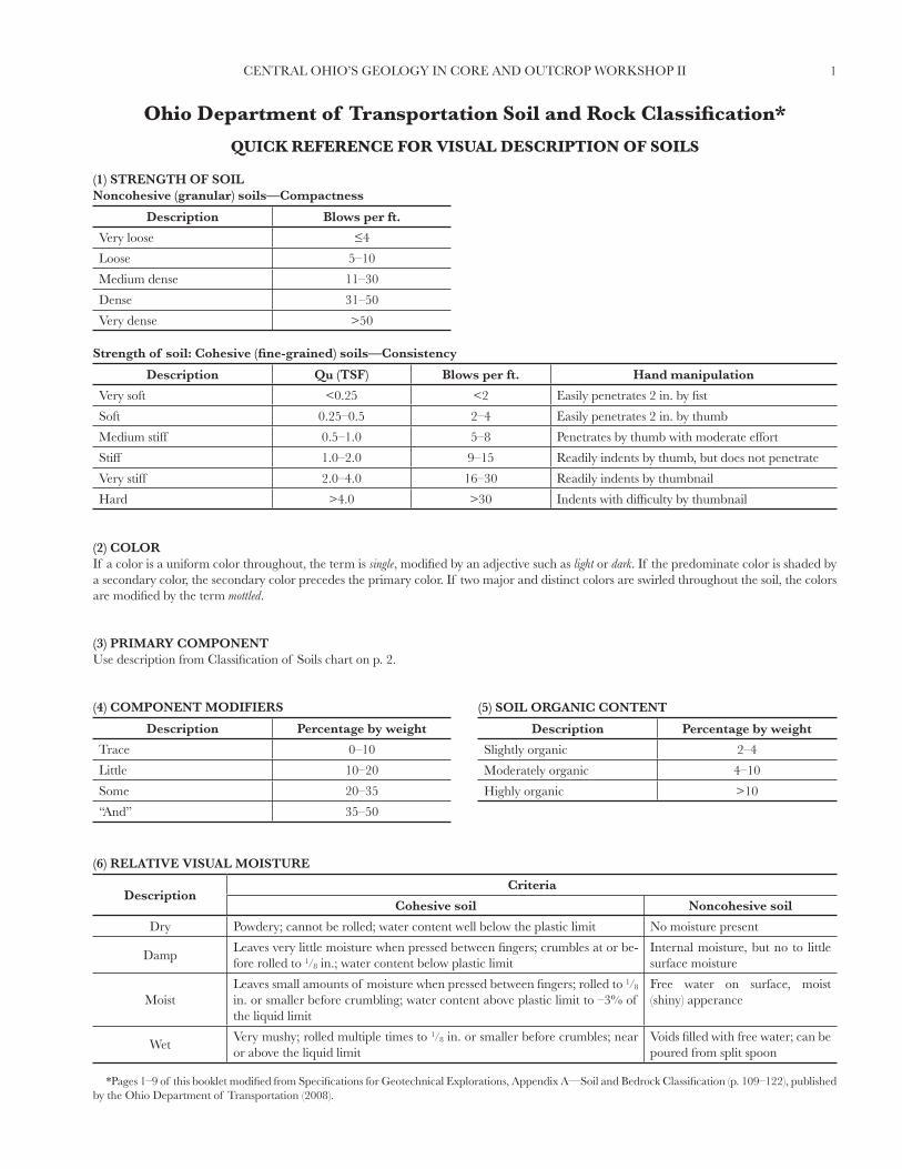
QUICK REFERENCE FOR VISUAL DESCRIPTION OF SOILS
(1) STRENGTH OF SOILNoncohesive (granular) soils—Compactness
Description Blows per ft.
Very loose ≤4
Loose 5–10
Medium dense 11–30
Dense 31–50
Very dense >50
Strength of soil: Cohesive (fi ne-grained) soils—Consistency
Description Qu (TSF) Blows per ft. Hand manipulation
Very soft <0.25 <2 Easily penetrates 2 in. by fi st
Soft 0.25–0.5 2–4 Easily penetrates 2 in. by thumb
Medium stiff 0.5–1.0 5–8 Penetrates by thumb with moderate effort
Stiff 1.0–2.0 9–15 Readily indents by thumb, but does not penetrate
Very stiff 2.0–4.0 16–30 Readily indents by thumbnail
Hard >4.0 >30 Indents with diffi culty by thumbnail
(2) COLORIf a color is a uniform color throughout, the term is single, modifi ed by an adjective such as light or dark. If the predominate color is shaded by a secondary color, the secondary color precedes the primary color. If two major and distinct colors are swirled throughout the soil, the colors are modifi ed by the term mottled.
(3) PRIMARY COMPONENTUse description from Classifi cation of Soils chart on p. 2.
(4) COMPONENT MODIFIERS
Description Percentage by weight
Trace 0–10
Little 10–20
Some 20–35
“And” 35–50
(5) SOIL ORGANIC CONTENT
Description Percentage by weight
Slightly organic 2–4
Moderately organic 4–10
Highly organic >10
(6) RELATIVE VISUAL MOISTURE
DescriptionCriteria
Cohesive soil Noncohesive soil
Dry Powdery; cannot be rolled; water content well below the plastic limit No moisture present
DampLeaves very little moisture when pressed between fi ngers; crumbles at or be-fore rolled to 1⁄8 in.; water content below plastic limit
Internal moisture, but no to little surface moisture
MoistLeaves small amounts of moisture when pressed between fi ngers; rolled to 1⁄8 in. or smaller before crumbling; water content above plastic limit to –3% of the liquid limit
Free water on surface, moist (shiny) apperance
WetVery mushy; rolled multiple times to 1⁄8 in. or smaller before crumbles; near or above the liquid limit
Voids fi lled with free water; can be poured from split spoon
Ohio Department of Transportation Soil and Rock Classifi cation*
*Pages 1–9 of this booklet modifi ed from Specifi cations for Geotechnical Explorations, Appendix A—Soil and Bedrock Classifi cation (p. 109–122), published by the Ohio Department of Transportation (2008).

2 CENTRAL OHIO’S GEOLOGY IN CORE AND OUTCROP WORKSHOP II
CLASSIFICATION OF SOILSOhio Department of Transportation
(The classifi cation of a soil is found by proceeding from top to bottom of the chart. The fi rst classifi cation that the test data fi ts is the correct classifi cation.)
Sym-bol
DescriptionClassifi cation LLO/LL
x 100*Percent
pass #40Percent
pass #200Liquid
Limit (LL)Plastic In-
dex (PI)Group in-dex max.
RemarksAASHTO OHIO
Gravel and/or stone fragments
A-1-a 30 max. 15 max. 6 max 0
Min. of 50% combined gravel, cobble, andboulder sizes
Gravel and/or stone fragments with sand
A-1-b 50 max. 25 max. 6 max. 0
Fine sand A-3 51 min. 10 max. Nonplastic 0
Coarse and fi ne sand A-3a 35 max. 6 max. 0
Min. of 50% combined coarse and fi ne sand sizes
Gravel and/or stone fragments with sand and silt
A-2-435 max.
40 max.10 max. 0
A-2-5 41 min.
Gravel and/or stone fragments with sand, silt, and clay
A-2-6
35 max.
40 max.
11 min. 4A-2-7 41 min.
Sandy silt A-4 A-4a 76 min. 36 min. 40 max. 10 max. 8Less than 50% silt sizes
Silt A-4 A-4b 76 min. 50 min. 40 max. 10 max. 850% or more silt sizes
Elastic silt and clay
A-5 76 min. 36 min. 41 min. 10 max. 12
Silt and clay A-6 A-6a 76 min. 36 min. 40 max. 11–15 10
Silty clay A-6 A-6b 76 min. 36 min. 40 max. 16 min. 16
Elastic clay A-7-5 76 min. 36 min. 41 min. ≤LL–30 20
Clay A-7-6 76 min. 36 min. 41 min. >LL–30 20
Organic silt A-8 A-8a 75 max. 36 min.Without organics would classify as A-4a or A-4b
Organic clay A-8 A-8b 75 max. 36 min.
Without organics would classify as A-5, A-6a, A-6b, A-7-5, or A-7-6
Material classifi ed by visual inspection
Sod and topsoil
Pavement or base
Uncontrolled fi ll(describe)
Bouldery zone Peat: S–sedimentary; W–woody;F–fi brous; L–loamy; etc.
*Only perform the oven-dried liquid limit test and this calculation if organic material is present in the sample.

3CENTRAL OHIO’S GEOLOGY IN CORE AND OUTCROP WORKSHOP II
QUICK REFERENCE GUIDE FOR ROCK DESCRIPTION
(1) ROCK TYPECommon rock types are: claystone, coal, dolomite, limestone, sandstone, siltstone, and shale.
(2) COLORTo be determined when rock is wet. When using the GSA color charts, use only name, not code.
(3) WEATHERING
Description Field parameter
UnweatheredNo evidence of any chemical or mechanical alteration of the rock mass. Mineral crystals have a bright appearance with no discoloration. Fractures show little or no staining on surfaces.
Slightly weatheredSlight discoloration of the rock surface with minor alterations along discontinuities. Less than 10% of the rock volume presents alteration.
Moderately weatheredPortions of the rock mass are discolored as evident by a dull appearance. Surfaces may have a pitted appearance with weathering “halos” evident. Isolated zones of varying rock strengths due to alteration may be present; 10 to 15% of the rock volume presents alterations.
Highly weatheredEntire rock mass appears discolored and dull. Some pockets of slightly to moderately weathered rock may be pres-ent and some areas of severely weathered materials may be present.
Severely weatheredMajority of the rock mass reduced to a soil-like state with relic rock structure discernable. Zones of more resistant rock may be present, but the material can generally be molded and crumbled by hand pressures.
(4) RELATIVE STRENGTH
Description Field parameter
Very weakCore can be carved with a knife and scratched by fi ngernail. Can be excavated readily with a point of a pick. Pieces 1 inch or more in thickness can be broken by fi nger pressure.
WeakCore can be grooved or gouged readily by a knife or pick. Can be excavated in small fragments by moderate blows of a pick point. Small, thin pieces can be broken by fi nger pressure.
Slightly strongCore can be grooved or gouged 0.05 inch deep by fi rm pressure of a knife or pick point. Can be excavated in small chips to pieces about 1 inch maximum size by hard blows of the point of a geologist’a pick.
Moderately strongCore can be scratched with a knife or pick. Grooves or gouges to 1⁄4 inch deep can be excavated by hand blows of a geologist’s pick. Requires moderate hammer blows to detach hand specimen.
StrongCore can be scratched with a knife or pick only with diffi culty. Requires hard hammer blows to detach hand speci-men. Sharp and resistant edges are present on hand specimen.
Very strongCore cannot be scratched by a knife or sharp pick. Breaking of hand specimens requires hard repeated blows of a geologist’s hammer.
Extremely strongCore cannot be scratched by a knife or sharp pick. Chipping of hand specimens requires hard repeated blows of a geologist’s hammer.
(5) TEXTURE
Component Grain diameter (in.)
Boulder >12
Cobble 3–12
Gravel 0.08–3
Sand
Coarse 0.02–0.08
Medium 0.01–0.02
Fine 0.005–0.01
Very fi ne 0.003–0.005
(6) BEDDING
Description Thickness (in.)
Very thick >36
Thick 18–36
Medium 10–18
Thin 2–10
Very thin 0.4–2
Laminated 0.1–0.4
Thinly laminated <0.1

4 CENTRAL OHIO’S GEOLOGY IN CORE AND OUTCROP WORKSHOP II
(7) DESCRIPTORS
Arenaceous—sandy Conglomeritic—contains rounded to subrounded gravel Friable—easily broken down
Argillaceous—clayey Crystalline—contains crystalline structure Micaceous—contains mica
Brecciated—contains angular to suban-gular gravel
Dolomitic—contains calcium/magnesium carbonate Pyritic—contains pyrite
Calcareous—contains calcium carbonate Ferriferous —contains iron Siliceous—contains silica
Carbonaceous—contains carbon Fissile—thin planar partingsStylolitic—contains stylotites (suture-like structure)
Cherty—contains chert fragments Fossiliferous—contains fossils Vuggy—contains openings
(8) DISCONTINUITIESDiscontinuity Types
Type Parameters
Fault Fracture which expresses displacement parallel to the surface and does not result in a polished surface.
Joint Planar fracture that does not express displacement. Generally occurs at regularly spaced intervals.
Shear Fracture which expresses displacement parallel to the surface and results in polished surfaces or slickensides.
Bedding A surface produced along a bedding plane.
Contact A surface produced along a contact plane. Generally not seen in Ohio.
Degree of Fracturing
Description Spacing
Unfractured >10 ft.
Intact 3–10 ft.
Slightly fractured 1–3 ft.
Moderately fractured 4–12 in.
Fractured 2–4 in.
Highly fractured <2 in.
Aperture Width
Description Spacing (in.)
Open >0.2
Narrow 0.05–0.2
Tight <0.05
Surface Roughness
Description Criteria
Very rough Near vertical steps and ridges occur on the discontinuity surface.
Slightly rough Asperities on the discontinuity surface are distinguishable and can be felt.
Slickensided Surface has a smooth, glassy fi nish with visual evidence of striation.
(9) RQD
(10) LOSSWhere LR = Run length, RR = Run recovery, LU = Rock unit length, and RU = Rock unit recovery.
�� �������� ������
��
����� ����� ����� ���� �����
������������
�����
���������
RQD = ∑ Length of pieces >4 inches *100
Total length of coreRQD = 25 + 33 + 20 + 12
*100 = 75% 120
Run loss = LR – RR *100
LRUnit loss = LU – RU
*100 LU

5CENTRAL OHIO’S GEOLOGY IN CORE AND OUTCROP WORKSHOP II
ROCK TYPE
GENERAL AND GLOSSARYThe following terms are used in describing the rock types found within Ohio. The following listing is presented in alphabetical order.
Term Defi nition
Amorphous Does not contain crystalline structure with shapeless appearance.
Anhydrous Does not contain water within the crystalline structure.
Bioturbated Evidence of past organisms, such as fi lled burrows, within the rock mass.
Conchoidal fracture A curved fracture plane with a rock mass.
Concretion A solidifi ed mass of concentrated material, usually of a single or multiple mineral composition.
Dilute HCl A liquid composed of a 10% hydrochloric acid solution.
Hydrous Contains water within the crystalline structure.
Hardness
When describing rock and minerals, the hardness of the material is commonly referred to. The hardness is the abil-ity of the material to resist scratching. The easier the material is scratched, the lower the hardness; and the more resistant the material is to scratching, the higher the hardness. The following table lists hardness of common items to aid in fi eld determinations:
Object Hardness
Fingernail 2.5
Copper penny (pre-1982) 3.5
Knife blade/nail 5.5
Window glass 5.5
Hardened steel (fi le) 6.5
Indurated Partially lithifi ed (hardened) sediment.
Lithifi ed Process during which unconsolidated sediments are formed into sedimentary rock.
Luster The ability of the material to refl ect light resulting in a surface appearance.
Vitreous Description referring to a glassy luster.
ROCK TYPESThe following are descriptions of the basic rock types found within Ohio. It should be noted that when referencing a percentage of composi-tion the percentage is based on volume not weight.
Rock type Description
AnhydriteA rock or mineral consisting of anhydrous calcium sulfate (CaSO4), which is common to massive evaporite beds and readily alters to gypsum. Anhydrite is white, has a vitreous or pearly luster, and a hardness of 3.5.
Breccia
A coarse-grained sedimentary rock comprised of more than 25% subangular to angular gravel, cobbles, and/or boul-ders. These grains are supported by either inter-grain contact or a matrix of sands, silt and/or clay and cemented by calcite, dolomite, hematite, silica or hardened clay. Color depends on the cementing agent with white, gray, yellow, or-ange, brown, and red colors common.
Chert
A hard dense sedimentary rock consisting of very fi ne quartz crystals and may contain amorphous silica or silica re-placed fossils. Chert varies in color, but commonly is white or ranges from brown to black, has a semi-vitreous to dull luster, and a hardness of 7. When broken it commonly produces conchoidal fractures. These fractures are smooth with sharp edges. Chert forms as oval or irregular nodular or concretionary segregations or as layered deposits in limestone and dolomite. Also referred to as fl int.
Claystone
A fi ne-grained rock formed of at least 75% clay-sized particles. Claystone is comprised of lithifi ed clay having the texture and composition of shale, but lacking the laminations and fi ssility of a shale. Generally has a blocky, thick to massive ap-pearance. Claystone may range in color from red, gray, olive, yellow, or brown with multiple colors typical. Slickensides are commonly found within claystone.

6 CENTRAL OHIO’S GEOLOGY IN CORE AND OUTCROP WORKSHOP II
Rock type(cont.)
Description(cont.)
CoalA combustible substance containing more than 50%, by weight, and more than 70%, by volume, of carbonaceous ma-terial; formed from the compaction and lithifi cation of plant remains. Colors of coals range from brown to black. It is generally lightweight with a shiny appearance on fresh surfaces.
Conglomerate
A coarse-grained sedimentary rock comprised of more than 25% rounded to subrounded gravel, cobbles, and/or boul-ders. These grains are supported by either inter-grain contact or a matrix of sands, silt and/or clay and cemented by calcite, hematite, silica or hardened clay. Color depends on the matrix and cementing agent with white, gray, yellow, orange, brown, and red colors common.
Dolomite
A sedimentary rock of which more than 50% consists of the mineral dolomite (calcium magnesium carbonate—CaMg(CO3)2) and less than 10% is comprised of the mineral calcite. It is commonly interbedded with limestone, and the magnesium can be replaced with ferrous iron. Dolomite typically has a hardness of 3.5 to 4, colors ranging from white to light gray, and will weakly react with cold dilute HCl on fresh or powdered surfaces.
Fireclay See underclay for description. The preferred use is underclay.
Flint A common name for chert, generally used by archaeologists. See chert for a description.
GypsumA rock or mineral consisting of hydrous calcium sulfate (CaSO4•2H2O). It forms thick extensive beds in Silurian-aged rock commonly associated with halite and anhydrite in evaporative deposits. Gypsum may be white, translucent, or transparent with a vitreous to pearly luster and a hardness of 2.0. Does not react with dilute HCl.
HaliteA rock or mineral occurring in massive, granular compact or cubic-crystalline forms associated with evaporite beds. It is comprised of sodium chloride (NaCl) and is commonly known as salt. Halite is colorless to white with a hardness of 2.0 to 2.5. Fresh samples will have a salty fl avor.
Ironstone
A sedimentary rock that is heavy and compact, containing primary components of iron oxides, carbonates, clay, and/or sand. Fresh surfaces generally are gray and weather (oxidize) to yellowish brown (limonite) to deep red (hematite), depending on the type and amount of oxide/hydroxide formed. It is very distinct in that its density is greater than a typical sedimentary rock.
Purer forms of ironstone occur as concretionary forms within shale, sandstone, and limestone or dolomite layers or at bedding contacts. Generally these concretionary forms are composed of goethite (Fe(OH), hardness 5.0–5.5), limonite (FeX(OH), hardness 4.0–5.5), or siderite (FeCO3 , hardness 3.5–4.5) and can be called “kidney ores” for their kidney shapes. Colors of these concretions vary between gray, yellowish brown, brown, brownish red, or black, depending upon the composition and degree of weathering.
Limestone
A sedimentary rock consisting of the mineral calcite (calcium carbonate—CaCO3). Impurities may include chert, clay, and minor mineral crystals. It may be crystalline (hard, pure, fi ne to coarse texture) with very fi ne grains not visible to the naked eye and/or fossiliferous (contains remains of organisms). Limestone is typically white to dark gray in color with a hardness of 3.5 to 4.0 and reacts vigorously with cold, dilute HCl. Descriptions based on Folk or Dunham Carbonate Classifi cation systems are not needed.
MudstoneA fi ne-grained sedimentary rock comprised of mud (silt and clay)-sized particles. Mudstone can be used as a generic term incorporating the rock classes of siltstone, claystone, and shale within Ohio. Although this term was widely used on past projects, the three previous descriptions are preferred for current projects. For a detailed description see claystone.
SandstoneA sedimentary rock comprised of grains of angular or rounded sand in a matrix of silt and/or clay cemented together by silica, iron oxides, or calcium carbonate. Sandstones may be composed of up to 25% of particles of gravel, cobble, and/or boulder sizes. Color depends on the cementing agent with white, gray, yellow, orange, brown, and red colors common.
Shale
A fi ne-grained sedimentary rock formed by the lithifi cation of clay, silt, or mud (predominate particle size is less than 0.002 mm). Shale has a laminated structure, which gives it fi ssility along which the rock splits readily. Shale is commonly interbedded with sandstone or limestone. Carbonaceous shale often grades into coal. Typical colors may be red, brown, black, green or gray.
SiltstoneA fi ne-grained sedimentary rock formed from particles fi ner than sand but coarser than clay. Siltstone is comprised of lithifi ed silt and lacks lamination or fi ssility. Typical colors may be gray, olive, or brown. Generally, siltstone has a fi ne-grit feeling when rubbed against teeth.
UnderclayA layer of clay laying immediately beneath a coal bed or carbonaceous shale. This layer may be bioturbated and indu-rated or lithifi ed. It is chiefl y comprised of siliceous or aluminous clay capable of withstanding high temperatures with-out deformation and may have a high shrink/swell potential.

7CENTRAL OHIO’S GEOLOGY IN CORE AND OUTCROP WORKSHOP II
ROCK DESCRIPTORSThe following listing of descriptors is for rock types found within Ohio. The following descriptors should be applied when the condition com-prises 10% or more of the observed sample by volume. If the condition comprises less than 10% use “contains . . .” For example if the core contains more than 10% mica, then the rock is “micaceous”; but if the rock is composed of 5% mica, then the rock “contains mica.” The following listing is presented in alphabetical order.
Percentage compositionDescription
>10 ≤10
Arenaceous NAContains sand-sized particles. Should not be used to describe sandstone, conglomer-ate, or breccia.
Argillaceous NAContains clay and/or silt-sized particles that result in the appearance having a slightly clayey texture. Should not be used to describe shale, claystone, or mudstone.
Brecciated NAContains less than 25% angular to subangular gravel, cobbles, and boulders. Typically used to describe sandstone, limestone, or dolomite.
Calcareous NAContains calcium carbonate indicated by reaction with HCl. Should not be used for describing limestone or dolomite.
Carbonaceous NAContains a signifi cant amount of carbon but is not combustible. Should not be used to describe coal.
Cherty Contains chert fragments Contains chert fragments.
Conglomeritic NAContains less than 25% rounded to subrounded gravel, cobbles, and boulders. Typi-cally used to describe sandstone, limestone, or dolomite.
Crystalline NAContains crystalline structure visible with the unaided eye or a 10-power hand lens. Generally referred to by the crystal size based upon texture chart, i.e., fi ne grained.
Dolomitic NAContains calcium/magnesium carbonate. Reacts slightly with dilute HCl on a fresh surface and slightly to moderately on a powdered surface. Should only be used with limestone.
Ferriferous/ferric Slightly ferric Contains iron-based minerals that are either visible or result in an increased density.
Fissile NA Partings along closely spaced planes parallel or nearly parallel to bedding.
Fossiliferous Contains fossilsContains remains of plant and animals, including carbonized fossils, silica, pyrite, or other mineral-replaced organisms and sand-, silt-, and/or clay-fi lled casts or burrows of organisms in most sedimentary rocks.
Friable NA Can be easily broken down with hand pressure.
Lithic Contains lithic fragmentsContains less than 25% rounded to angular rock fragments. Typically used to describe claystone.
Marine NAReference made to limestone and dolomites that were deposited in a salt-water marine environment.
Micaceous Contains mica Rock mass contains mica fragments.
Non-marine NAReference made to limestone and dolomites that were deposited in a fresh-water envi-ronment. Commonly also referred to as “impure.”
Petroliferous NA Contains free petroleum or petroleum staining, including natural asphalt.
Pyritic Contains pyrite Rock mass contains pyrite crystals or nodules.
Siliceous Contains silica Rock mass contains very fi ne to fi ne silica material.
Stylolitic NA Contains stylotites (cranial suture-like structures) within the rock mass.
Vuggy NAContains solution cavities that may or may not contain mineral crystals. Typically used to describe carbonate rocks.
8 CENTRAL OHIO’S GEOLOGY IN CORE AND OUTCROP WORKSHOP II
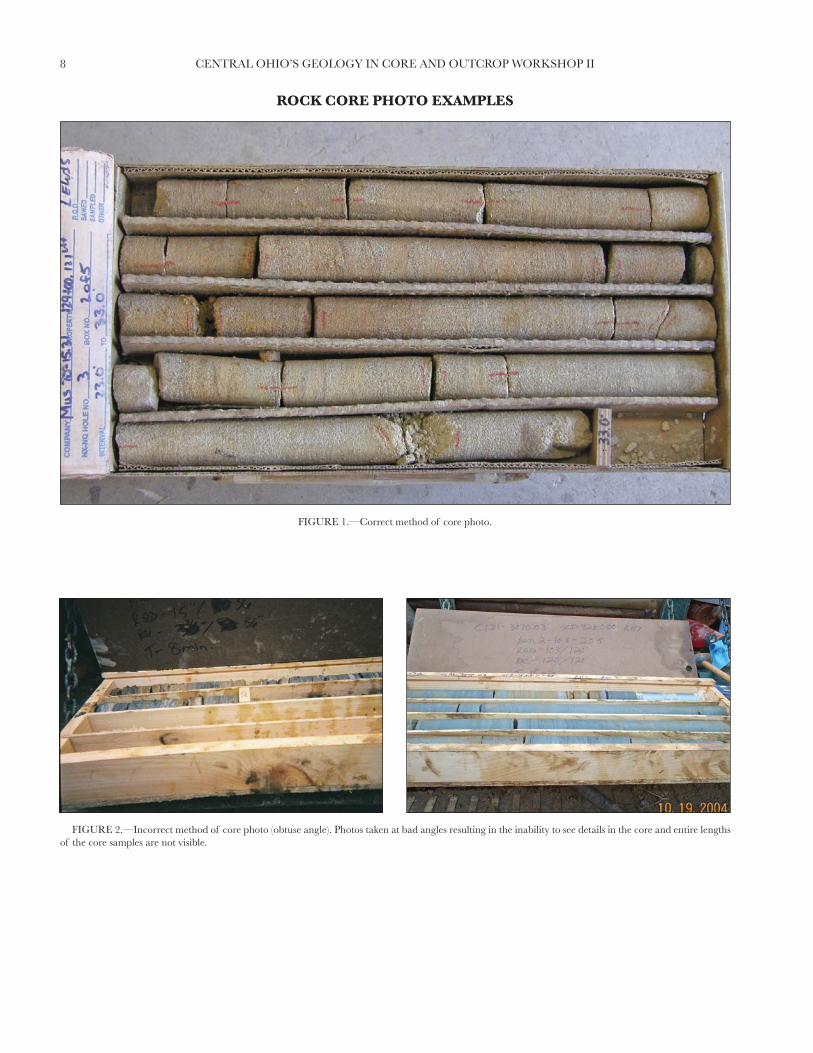
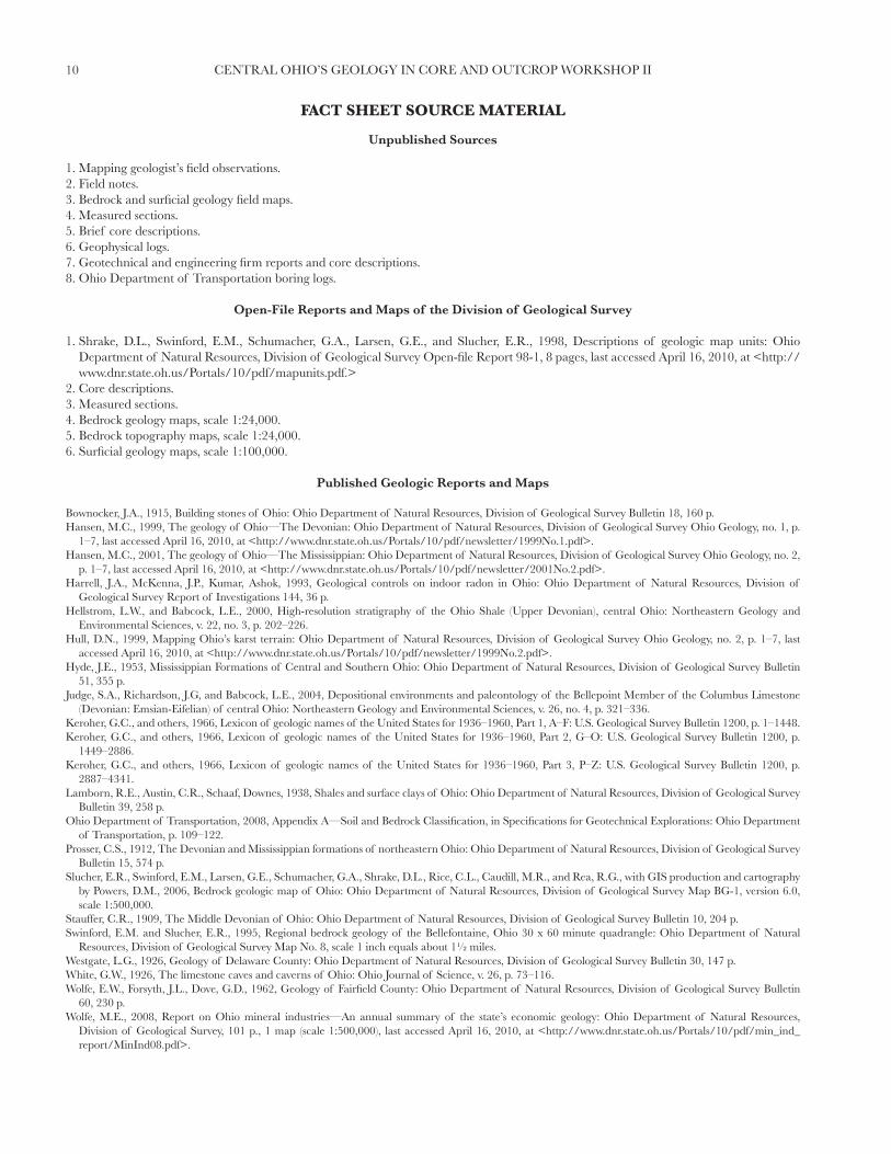
ROCK CORE PHOTO EXAMPLES
FIGURE 1.—Correct method of core photo.
FIGURE 2.—Incorrect method of core photo (obtuse angle). Photos taken at bad angles resulting in the inability to see details in the core and entire lengths of the core samples are not visible.

9CENTRAL OHIO’S GEOLOGY IN CORE AND OUTCROP WORKSHOP II
FIGURE 3.—Incorrect method of core photo (shading). Photos taken with shading over the cores result in the inability to distinguish the entire character-istics of the core samples.
10 CENTRAL OHIO’S GEOLOGY IN CORE AND OUTCROP WORKSHOP II
FACT SHEET SOURCE MATERIAL
Unpublished Sources
1. Mapping geologist’s fi eld observations.2. Field notes.3. Bedrock and surfi cial geology fi eld maps.4. Measured sections.5. Brief core descriptions.6. Geophysical logs.7. Geotechnical and engineering fi rm reports and core descriptions.8. Ohio Department of Transportation boring logs.
Open-File Reports and Maps of the Division of Geological Survey
1. Shrake, D.L., Swinford, E.M., Schumacher, G.A., Larsen, G.E., and Slucher, E.R., 1998, Descriptions of geologic map units: Ohio Department of Natural Resources, Division of Geological Survey Open-fi le Report 98-1, 8 pages, last accessed April 16, 2010, at <http://www.dnr.state.oh.us/Portals/10/pdf/mapunits.pdf.>
2. Core descriptions.3. Measured sections.4. Bedrock geology maps, scale 1:24,000.5. Bedrock topography maps, scale 1:24,000.6. Surfi cial geology maps, scale 1:100,000.
Published Geologic Reports and Maps
Bownocker, J.A., 1915, Building stones of Ohio: Ohio Department of Natural Resources, Division of Geological Survey Bulletin 18, 160 p. Hansen, M.C., 1999, The geology of Ohio—The Devonian: Ohio Department of Natural Resources, Division of Geological Survey Ohio Geology, no. 1, p.
1–7, last accessed April 16, 2010, at <http://www.dnr.state.oh.us/Portals/10/pdf/newsletter/1999No.1.pdf>.Hansen, M.C., 2001, The geology of Ohio—The Mississippian: Ohio Department of Natural Resources, Division of Geological Survey Ohio Geology, no. 2,
p. 1–7, last accessed April 16, 2010, at <http://www.dnr.state.oh.us/Portals/10/pdf/newsletter/2001No.2.pdf>. Harrell, J.A., McKenna, J.P., Kumar, Ashok, 1993, Geological controls on indoor radon in Ohio: Ohio Department of Natural Resources, Division of
Geological Survey Report of Investigations 144, 36 p.Hellstrom, L.W., and Babcock, L.E., 2000, High-resolution stratigraphy of the Ohio Shale (Upper Devonian), central Ohio: Northeastern Geology and
Environmental Sciences, v. 22, no. 3, p. 202–226. Hull, D.N., 1999, Mapping Ohio’s karst terrain: Ohio Department of Natural Resources, Division of Geological Survey Ohio Geology, no. 2, p. 1–7, last
accessed April 16, 2010, at <http://www.dnr.state.oh.us/Portals/10/pdf/newsletter/1999No.2.pdf>.Hyde, J.E., 1953, Mississippian Formations of Central and Southern Ohio: Ohio Department of Natural Resources, Division of Geological Survey Bulletin
51, 355 p.Judge, S.A., Richardson, J.G, and Babcock, L.E., 2004, Depositional environments and paleontology of the Bellepoint Member of the Columbus Limestone
(Devonian: Emsian-Eifelian) of central Ohio: Northeastern Geology and Environmental Sciences, v. 26, no. 4, p. 321–336.Keroher, G.C., and others, 1966, Lexicon of geologic names of the United States for 1936–1960, Part 1, A–F: U.S. Geological Survey Bulletin 1200, p. 1–1448.Keroher, G.C., and others, 1966, Lexicon of geologic names of the United States for 1936–1960, Part 2, G–O: U.S. Geological Survey Bulletin 1200, p.
1449–2886.Keroher, G.C., and others, 1966, Lexicon of geologic names of the United States for 1936–1960, Part 3, P–Z: U.S. Geological Survey Bulletin 1200, p.
2887–4341.Lamborn, R.E., Austin, C.R., Schaaf, Downes, 1938, Shales and surface clays of Ohio: Ohio Department of Natural Resources, Division of Geological Survey
Bulletin 39, 258 p.Ohio Department of Transportation, 2008, Appendix A—Soil and Bedrock Classifi cation, in Specifi cations for Geotechnical Explorations: Ohio Department
of Transportation, p. 109–122.Prosser, C.S., 1912, The Devonian and Mississippian formations of northeastern Ohio: Ohio Department of Natural Resources, Division of Geological Survey
Bulletin 15, 574 p.Slucher, E.R., Swinford, E.M., Larsen, G.E., Schumacher, G.A., Shrake, D.L., Rice, C.L., Caudill, M.R., and Rea, R.G., with GIS production and cartography
by Powers, D.M., 2006, Bedrock geologic map of Ohio: Ohio Department of Natural Resources, Division of Geological Survey Map BG-1, version 6.0, scale 1:500,000.
Stauffer, C.R., 1909, The Middle Devonian of Ohio: Ohio Department of Natural Resources, Division of Geological Survey Bulletin 10, 204 p.Swinford, E.M. and Slucher, E.R., 1995, Regional bedrock geology of the Bellefontaine, Ohio 30 x 60 minute quadrangle: Ohio Department of Natural
Resources, Division of Geological Survey Map No. 8, scale 1 inch equals about 1½ miles.Westgate, L.G., 1926, Geology of Delaware County: Ohio Department of Natural Resources, Division of Geological Survey Bulletin 30, 147 p.White, G.W., 1926, The limestone caves and caverns of Ohio: Ohio Journal of Science, v. 26, p. 73–116.Wolfe, E.W., Forsyth, J.L., Dove, G.D., 1962, Geology of Fairfi eld County: Ohio Department of Natural Resources, Division of Geological Survey Bulletin
60, 230 p.Wolfe, M.E., 2008, Report on Ohio mineral industries—An annual summary of the state’s economic geology: Ohio Department of Natural Resources,
Division of Geological Survey, 101 p., 1 map (scale 1:500,000), last accessed April 16, 2010, at <http://www.dnr.state.oh.us/Portals/10/pdf/min_ind_report/MinInd08.pdf>.

11CENTRAL OHIO’S GEOLOGY IN CORE AND OUTCROP WORKSHOP II
GEOLOGIC TIME SCALE
Phan
erozo
ic
cioz
one
Cci
ozose
Mci
ozoela
P
EraEon System/Period(Subsystem)
Cretaceous
Jurassic
Triassic
Permian
Quaternary
(Neogene)
(Paleogene)
(Pennsylvanian)
(Mississippian)
Devonian
Silurian
Ordovician
Cambrian
65.5
Car
bonifer
ous
Neoproterozic
Mesoproterozic
Paleoproterozic
Neoarchean
Mesoarchean
Paleoarchean
Eoarchean
Age at base(millions of years)
1.8
23.0
Pro
tero
zoic
Arc
hea
n
145.5
199.6
251.0
299.0
318.1
359.2
416.0
443.7
488.3
542.0
2,500
3,600
4,550origin of earth
base notdefined
(modified from Gradstein, F.M., Ogg, J.G., Smith, A.G., and others, 2004 [2005], A geologic time scale 2004: Cambridge University Press, 589 p.)
Ter
tiar
y
Pre
cam
bria
n

12 CENTRAL OHIO’S GEOLOGY IN CORE AND OUTCROP WORKSHOP II
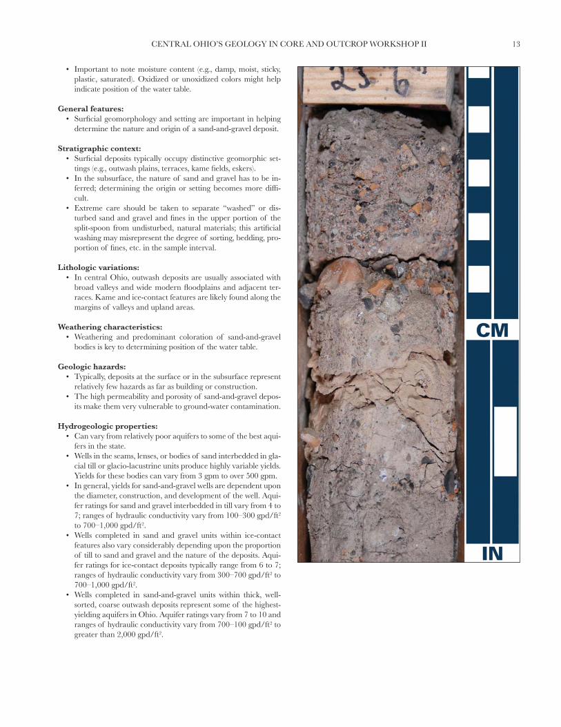
Glacial Sand-and-Gravel Deposits
Sand and GravelDuring the Pleistocene Epoch (2 million–10,000 years before present), several episodes of ice advance occurred in
central Ohio. The last advance, the Late Wisconsinan Ice Sheet, deposited surfi cial materials in central Ohio. The major-ity of the glacial deposits in central Ohio are of three main types: (glacial) till; lacustrine deposits; and sand-and-gravel deposits, which range from disconnected lenses within glacial till to outwash sand-and-gravel (valley train) deposits and ice-contact sand-and-gravel (kames, eskers) deposits. Drift is an older term that collectively refers to the entire sequence of glacial deposits.
Sand-and-gravel lenses interbedded in glacial till can vary considerably, ranging from a few inches thick and a few feet in lateral extent to over 20 ft in thickness and extending over a mile laterally. Lenses can vary from stratifi ed and bedded to relatively uniform to almost chaotic in nature.
Outwash deposits are created by active deposition of sediments by meltwater streams and are generally bedded, or stratifi ed, and sorted. Sorting and degree of coarseness depend on the nature and proximity of the melting ice sheet. De-position of outwash may precede an advancing ice sheet or be associated with a melting ice sheet.
Kames and eskers are ice-contact features. They are composed of masses of generally poorly sorted sand and gravel with minor till, deposited in depressions, holes, tunnels, or other cavities in the ice. As the surrounding ice melts, a mound of sediment remains behind. Typically, these deposits may collapse or fl ow as the surrounding ice melts. These deposits may display high-angle, distorted or tilted beds, faults, and folds. Kames are comprised of isolated or small groups of rounded mounds of dirty sand and gravel with minor till. Eskers are comprised of elongated, narrow, sinuous ridges of sand and gravel.
Diagnostic features:• Sand, gravel, or a combination of the two are dominant.• Deposits vary from relatively loose and friable to very dense and cohesive. Moisture conditions and presence of mi-
nor fi nes greatly increases stickiness and cohesiveness.• Can vary from well to poorly sorted to chaotic. Deposits may be relatively uniform or highly variable and viewed as
being “clean” or “dirty.” Bedding can be highly variable and massive, parallel, cross-bedded, gradational, or other-wise.
Sand and gravel pit illustrating thick, cross-bedded sand beds underlying an extensive sand-and-gravel deposit (Hamilton County).
13CENTRAL OHIO’S GEOLOGY IN CORE AND OUTCROP WORKSHOP II
• Important to note moisture content (e.g., damp, moist, sticky, plastic, saturated). Oxidized or unoxidized colors might help indicate position of the water table.
General features:• Surfi cial geomorphology and setting are important in helping
determine the nature and origin of a sand-and-gravel deposit.
Stratigraphic context:• Surfi cial deposits typically occupy distinctive geomorphic set-
tings (e.g., outwash plains, terraces, kame fi elds, eskers).• In the subsurface, the nature of sand and gravel has to be in-
ferred; determining the origin or setting becomes more diffi -cult.
• Extreme care should be taken to separate “washed” or dis-turbed sand and gravel and fi nes in the upper portion of the split-spoon from undisturbed, natural materials; this artifi cial washing may misrepresent the degree of sorting, bedding, pro-portion of fi nes, etc. in the sample interval.
Lithologic variations:• In central Ohio, outwash deposits are usually associated with
broad valleys and wide modern fl oodplains and adjacent ter-races. Kame and ice-contact features are likely found along the margins of valleys and upland areas.
Weathering characteristics:• Weathering and predominant coloration of sand-and-gravel
bodies is key to determining position of the water table.
Geologic hazards:• Typically, deposits at the surface or in the subsurface represent
relatively few hazards as far as building or construction.• The high permeability and porosity of sand-and-gravel depos-
its make them very vulnerable to ground-water contamination.
Hydrogeologic properties:• Can vary from relatively poor aquifers to some of the best aqui-
fers in the state.• Wells in the seams, lenses, or bodies of sand interbedded in gla-
cial till or glacio-lacustrine units produce highly variable yields. Yields for these bodies can vary from 3 gpm to over 500 gpm.
• In general, yields for sand-and-gravel wells are dependent upon the diameter, construction, and development of the well. Aqui-fer ratings for sand and gravel interbedded in till vary from 4 to 7; ranges of hydraulic conductivity vary from 100–300 gpd/ft2 to 700–1,000 gpd/ft2.
• Wells completed in sand and gravel units within ice-contact features also vary considerably depending upon the proportion of till to sand and gravel and the nature of the deposits. Aqui-fer ratings for ice-contact deposits typically range from 6 to 7; ranges of hydraulic conductivity vary from 300–700 gpd/ft2 to 700–1,000 gpd/ft2.
• Wells completed in sand-and-gravel units within thick, well-sorted, coarse outwash deposits represent some of the highest-yielding aquifers in Ohio. Aquifer ratings vary from 7 to 10 and ranges of hydraulic conductivity vary from 700–100 gpd/ft2 to greater than 2,000 gpd/ft2.

14 CENTRAL OHIO’S GEOLOGY IN CORE AND OUTCROP WORKSHOP II
Glacial Lacustrine
During the Pleistocene Epoch (2 million–10,000 years before present), several episodes of ice advance occurred in central Ohio. The last advance, the Late Wisconsinan Ice Sheet, deposited surfi cial materials in central Ohio, the major-ity of which are of three main types: (glacial) till, lacustrine deposits, and sand-and-gravel deposits. Drift, an older term, collectively refers to the entire sequence of glacial deposits.
Lacustrine deposits tend to be laminated (or varved) and contain various proportions of silts and clays. Thin layers of fi ne sand interbedded with the clayey to silty lacustrine deposits may refl ect storm or fl ood events. The net produces a “wafer-like” appearance. Permeability is preferentially horizontal due to the laminations. The inherent vertical perme-ability is low, but may be increased by secondary porosity features, such as fractures, joints, root channels, etc. Intermo-rainal lakes are a major source of thin, near-surface lacustrine deposits in central Ohio. The lakes were created during the recession of the ice sheets when meltwater was trapped between the ice and end moraines. In some areas meltwater may have been trapped between two end moraines, forming a lake.
Slack-water ponds and lakes are the other major type of lacustrine deposits in central Ohio. These deposits were formed as ice advanced into a valley setting and blocked drainageways. They were also caused by tributary streams that overfl owed as their base stream migrated away or became choked with coarse sediments.
Diagnostic features:• Usually defi ned texturally or grain-sized as a silty clay or clayey silt. May display thin bedding, laminations, or
varves. Deposits might appear massive and uniform and lack bedding. Individual intervals tend to be uniform and well-sorted.
• Deposits tend to be less compacted and dense than till and are relatively soft, plastic, and sticky. They lack the gravel, cobbles, and coarse sand content of till. Sand typically appears in discrete bands or laminae as opposed to being dis-seminated throughout the matrix.
• Important to note moisture content (e.g., damp, moist, saturated).
General features:• Typically silty to clayey. Laminations, beds, varves may be common. Individual layers tend to be well sorted and
uniform.
Glacial Lacustrine Deposits
Thin-bedded and laminated lacustrine deposits (Sandusky County).

15CENTRAL OHIO’S GEOLOGY IN CORE AND OUTCROP WORKSHOP II
• Gray where unoxidized; brown where weathered; mottled col-ors may represent variable water table conditions.
Stratigraphic context:• May represent the uppermost surfi cial unit in low-lying areas.• Deposits in the subsurface interbedded with till may indicate
former intermorainal lakes or blockage of drainage by advanc-ing ice.
• Deposits interbedded with coarser, water-laid sands and grav-els indicate a substantial change in water energy and a local change in drainage.
Lithologic variations:• In central Ohio, intermorainal lakes may be silty or clayey, de-
pending upon the nature of surrounding till and adjacent ma-terials supplying sediments to the lakes.
Weathering characteristics:• Important to note weathering characteristics, degree of oxida-
tion, mottling of colors, presence of fractures and joints, pres-ence of secondary carbonate or gypsum.
• The degree of weathering is important in determining the hy-drogeologic properties of the material, including permeability.
Geologic hazards:• Lacustrine bluffs or steeper slopes with a higher water table
may be especially unstable and prone to slumping. A number of building constraints based upon such conditions include suitability for basements, foundations, septic systems, leach fi elds, etc.
Hydrogeologic properties:• Monitor wells installed in the saturated zone typically will
maintain water.• Recharge and water movement is variable. These deposits are
generally viewed as impermeable and comprising an aquita-rd. Research shows that recharge and water movement occurs in these deposits, particularly when weathered and fractured. Lab tests show permeability ranging from 10-7 to 10-9 cm/sec2, whereas in situ tests based upon slug tests; long-term, low-yield pumping tests; and others may reveal permeabilities in the range of 10-6cm/sec2. Permeability and fl ow are preferentially horizontal, especially when deposits are highly laminated or bedded. Shallow ground-water fl ow in these deposits will typi-cally fl ow towards the nearest shallow stream or drainage ditch.

16 CENTRAL OHIO’S GEOLOGY IN CORE AND OUTCROP WORKSHOP II
During the Pleistocene Epoch (2 million–10,000 years before present), several episodes of ice advance occurred in central Ohio. The last advance, the Late Wisconsinan Ice Sheet, deposited surfi cial materials in central Ohio, the major-ity of which are of three main types: (glacial) till, lacustrine deposits, and sand-and-gravel deposits. Drift, an older term, collectively refers to the entire sequence of glacial deposits.
Till is an unsorted, non-stratifi ed (non-bedded) mixture of sand, gravel, silt, and clay deposited directly by the ice sheet. Till also may be referred to as a diamict, which has the same defi nition as far as the nature of the material but lacks the genetic implication of glacial deposition. There are two main types or facies of glacial till: lodgment till and ablation till. Lodgment till, which is “plastered-down” or “bulldozed” at the base of an actively moving ice sheet, tends to be relatively dense and compacted, and pebbles typically are angular or broken and have a preferred direction or orientation. “Hard-pan” and “boulder-clay” are two common terms used for lodgment till. Ablation or “melt-out” till occurs as the ice sheet melts or stagnates away. Debris bands are laid down or stacked as the ice between the bands melts. Ablation till tends to be less dense, less compacted, and slightly coarser as meltwater commonly washes away some of the fi ne silt and clay.
Till has relatively low inherent permeability. Permeability in till is in part dependent upon the primary porosity of the till, which refl ects how fi nely textured the particular till is. Vertical permeability in till is controlled largely by factors infl uencing secondary porosity, such as fractures (joints), root channels, sand seams, etc. Fractures may also interconnect the sand-and-gravel lenses.
At the land surface, till accounts for two primary landforms: ground moraine and end moraine. Ground moraine (till plain) is relatively fl at to gently rolling. End moraines are ridge-like with terrain that is steeper and more rolling or hum-mocky. Typically, till is thinner in areas of ground moraine and thicker in end moraines.
Diagnostic features:• Usually defi ned texturally or grain-sized as a silty clay or clayey silt. May have signifi cant proportion of fi ne to coarse
sand and gravel, pebbles, or cobbles surrounded by a matrix of fi ner-grained materials.• Typically lacks bedding, sorting, and laminations.• Highly compacted, massive, and dense (lodgment till), ranging to more loosely compacted, friable, and disaggregates
relatively easily (ablation or highly-weathered till).• Important to note structure (e.g., massive, blocky, prismatic).• Important to note moisture content (e.g., damp, moist, sticky, plastic, saturated).
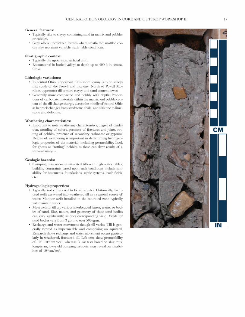
Glacial Till
Glacial Till
Weathered exposure of clay-rich glacial till containing occasional pebbles, cobbles, and boulders (Hamilton County).
17CENTRAL OHIO’S GEOLOGY IN CORE AND OUTCROP WORKSHOP II
General features:• Typically silty to clayey, containing sand in matrix and pebbles
or cobbles.• Gray where unoxidized; brown where weathered; mottled col-
ors may represent variable water table conditions.
Stratigraphic context:• Typically the uppermost surfi cial unit.• Encountered in buried valleys to depth up to 400 ft in central
Ohio.
Lithologic variations:• In central Ohio, uppermost till is more loamy (silty to sandy)
mix south of the Powell end moraine. North of Powell Mo-raine, uppermost till is more clayey and sand content lower.
• Generally more compacted and pebbly with depth. Propor-tions of carbonate materials within the matrix and pebble con-tent of the till change sharply across the middle of central Ohio as bedrock changes from sandstone, shale, and siltstone to lime-stone and dolomite.
Weathering characteristics:• Important to note weathering characteristics, degree of oxida-
tion, mottling of colors, presence of fractures and joints, rot-ting of pebbles, presence of secondary carbonate or gypsum. Degree of weathering is important in determining hydrogeo-logic properties of the material, including permeability. Look for ghosts or “rotting” pebbles as these can skew results of a textural analysis.
Geologic hazards:• Slumping may occur in saturated tills with high water tables;
building constraints based upon such conditions include suit-ability for basements, foundations, septic systems, leach fi elds, etc.
Hydrogeologic properties:• Typically not considered to be an aquifer. Historically, farms
used wells excavated into weathered till as a seasonal source of water. Monitor wells installed in the saturated zone typically will maintain water.
• Most wells in till tap various interbedded lenses, seams, or bod-ies of sand. Size, nature, and geometry of these sand bodies can vary signifi cantly, as does corresponding yield. Yields for sand bodies vary from 3 gpm to over 500 gpm.
• Recharge and water movement though till varies. Till is gen-erally viewed as impermeable and comprising an aquitard. Research shows recharge and water movement occurs particu-larly in weathered, fractured till. Lab tests show permeability of 10-7–10-9 cm/sec2, whereas in situ tests based on slug tests; long-term, low-yield pumping tests; etc. may reveal permeabil-ities of 10-5cm/sec2.

18 CENTRAL OHIO’S GEOLOGY IN CORE AND OUTCROP WORKSHOP II
Rocks forming the Mississippian Cuyahoga Formation were deposited in marginal marine, deltaic, or fl uvial deposi-tional environments producing a complex relationship of intertonguing and intergradational conglomerates, sandstones, siltstones, and shales. These sediments were eroded from the Devonian-age highlands and the Catskill and Pocono deltas to the east. Rivers and streams transported the eroded sediments into the marginal marine and newly forming deltas of Ohio during the Mississippian Period.
The Cuyahoga Formation, and overlying Logan Formation, occur along a 1- to 50-mile (1.6- to 80-km) wide, south-west-to-northeast oriented, outcrop belt that extends from Portsmouth, through Newark, Mansfi eld, Wooster, Akron, Warren, and into northwestern Pennsylvania. The Cuyahoga ranges in thickness from 50- to 650-feet (15- to 198-m) and was fi rst named for exposures along the Cuyahoga River between Akron and Cleveland in 1870. Historically, Cuyahoga Formation shale was mined for the manufacture of drain tile and paving, face, and hollow bricks, and sandstone from the formation was quarried for high-quality dimension stone.
Diagnostic features:• Vertical and horizontal variability of shale, siltstone, sandstone, and conglomerate lithologies.• Abundance of shale.
General features:• Shale interbedded with sandstone, siltstone, and conglomerate.• Gray, olive, brown, and yellow.• Thin to massive bedding.• Sparsely fossiliferous with local intervals of highly fossiliferous rocks.
Stratigraphic context:• Underlain by Sunbury Shale.
Cuyahoga Formation
Cuyahoga Formation
Weathered and heavily gullied exposure of the shale-rich Cuyahoga Formation along U.S. Route 23 in Scioto County.

19CENTRAL OHIO’S GEOLOGY IN CORE AND OUTCROP WORKSHOP II
• Overlain by Logan Formation.• Similar unit: Bedford Shale.
Stratigraphic contacts:• Sharp upper contact.• Sharp lower contact.
Weathering characteristics:• Shale of the Cuyahoga weathers to light-gray to light–brown,
clay-rich colluvium on natural slopes and at the bases of road cuts.
• Small landslides may form in colluvial deposits subject to over-steepening by stream erosion or undercutting natural slopes.
• Sandstone and conglomerate intervals are resistant to erosion and form abundant cliffs, waterfalls, gorges, rock-shelters, and natural bridges.
Economic geology:• Cuyahoga shale deposits are mined for production of bricks
and other clay products.• Sandstone quarried for dimension stone, crushed or broken
stone, glass sand, and other industrial uses.
Lithologic variations:• Along the outcrop belt of the Cuyahoga, some of the distinc-
tive stratigraphic intervals have been recognized as members, including: in southern Ohio, the Henley Shale, Portsmouth Shale, and Buena Vista Sandstone Members; in central Ohio, the Black Hand Member; and in northeastern Ohio, the Shenango Sandstone and Shale Member.
Scenic geology:• The Black Hand Member of the Cuyahoga Formation is the
best-known unit for forming waterfalls, cliff-lined gorges, and rock-shelter caves.
• Exposures of the Black Hand Member in Hocking County are well known for such spectacular scenic features as Ash Cave, Cedar Falls, Conkle’s Hollow, Old Man’s Cave, and Rock House.
• In Fairfi eld and Licking Counties, Rising Sun Park and Rock Mill Bridge Falls (in the Lancaster area) and Black Hand Gorge (east of Newark) are formed in the Black Hand.
Hydrogeologic properties:• Poor to moderate aquifer capable of supplying the needs of
households and small farms.• Average yield for shale and siltstone units is 3 to 10 gpm with a
maximum yield of about 15 gpm.• Average yield for the sandstone is 10–15 gpm with a maximum
yield of about 25 gpm.• Yield varies considerably along outcrop belt depending upon
the relative proportion of shale, siltstone, and sandstone and the abundance of fractures and joints intersecting bedding planes.
• Aquifer rating ranges from 3 to 5 depending upon the propor-tion of shale and siltstone to sandstone.
• Hydraulic conductivity ranges from 1–100 gpd/ft2 to 100–300 gpd/ft2.
20 CENTRAL OHIO’S GEOLOGY IN CORE AND OUTCROP WORKSHOP II
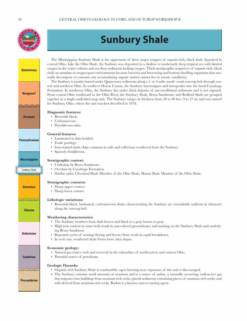
Sunbury Shale
Sunbury Shale
The Mississippian Sunbury Shale is the uppermost of three major tongues of organic-rich, black shale deposited in central Ohio. Like the Ohio Shale, the Sunbury was deposited in a shallow to moderately deep tropical sea with limited oxygen in the water column and sea fl oor sediments lacking oxygen. Thick stratigraphic sequences of organic-rich, black shale accumulate in oxygen-poor environments because bacteria and burrowing and bottom dwelling organisms that nor-mally decompose or consume any accumulating organic matter cannot live in anoxic conditions.
The Sunbury is mainly buried under Quaternary sediments along a 1- to 5-mile, north–south outcrop belt through cen-tral and northern Ohio. In southern Huron County, the Sunbury intertongues and intergrades into the basal Cuyahoga Formation. In northwest Ohio, the Sunbury lies under thick deposits of unconsolidated sediments and is not exposed. From central Ohio southward to the Ohio River, the Sunbury Shale, Berea Sandstone, and Bedford Shale are grouped together in a single undivided map unit. The Sunbury ranges in thickness from 30 to 90 feet (9 to 27 m) and was named for Sunbury, Ohio, where the unit was fi rst described in 1878.
Diagnostic features:• Brownish black.• Carbonaceous.• Petroliferous odor.
General features:• Laminated to thin bedded.• Fissile partings.• Iron-stained shale chips common in soils and colluvium weathered from the Sunbury.• Sparsely fossiliferous.
Stratigraphic context:• Underlain by Berea Sandstone.• Overlain by Cuyahoga Formation.• Similar units: Cleveland Shale Member of the Ohio Shale; Huron Shale Member of the Ohio Shale.
Stratigraphic contacts:• Sharp upper contact.• Sharp lower contact.
Lithologic variations:• Brownish-black, laminated, carbonaceous shales characterizing the Sunbury are remarkably uniform in character
along the outcrop belt.
Weathering characteristics:• The Sunbury weathers from dark brown and black to a gray brown to gray.• High iron content in some beds result in rust-colored groundwater and staining on the Sunbury Shale and underly-
ing Berea Sandstone.• Repeated cycles of wetting/drying and freeze/thaw result in rapid breakdown.• In rock cuts, weathered shale forms loose talus slopes.
Economic geology:• Natural gas source rock and reservoir in the subsurface of northeastern and eastern Ohio.• Potential source of petroleum.
Geologic Hazards:• Organic-rich Sunbury Shale is combustible; open burning near exposures of this unit is discouraged.• The Sunbury contains small amounts of uranium and is a source of radon, a naturally occurring, radioactive gas
that migrates into buildings from uranium-rich rocks; glacial sediments containing pieces of uranium-rich rocks; and soils derived from uranium-rich rocks. Radon is a known cancer-causing agent.

21CENTRAL OHIO’S GEOLOGY IN CORE AND OUTCROP WORKSHOP II
Hydrogeologic properties:• Typically poor aquifer; generally suitable for limited household
or small farm use.• Average yield 3 to 5 gpm, with a maximum of roughly 10 gpm.• Yield predominantly comes from a combination of joints and
fractures as they intersect bedding planes.• Best yields develop from the uppermost, weathered portion of
the formation.• Wells may be drilled deeper in the formation to obtain addi-
tional borehole storage.• High sulfi de and iron contents may represent a water quality
problem.• For best results, wells should be drilled through the Sunbury
and completed in the underlying Berea Sandstone. This allows the Sunbury Shale to be cased-off, if the water quality is ob-jectionable.
• Wells drilled into the overlying Cuyahoga Formation may be extended into the Sunbury if extra well-bore storage is needed, as long as water quality is not objectionable.
• Aquifer rating ranges from 2 to 3.• Hydraulic conductivity in the range of 1–100 gpd/ft2.
Engineering Properties:• Unconfi ned Compressive Strength—Slightly strong to strong.• Slake Durability—Good to very good.• Rippability—Non-rippable.
Contact between the thick sandstone beds of the Berea and the overlying black, organic-rich shales of the Sunbury. Note small landslide in the shale-rich Cuyahoga Formation exposed near the top of the road cut.

22 CENTRAL OHIO’S GEOLOGY IN CORE AND OUTCROP WORKSHOP II
The Berea Sandstone was deposited in deltas that built into the shallow tropical seas that covered Ohio in the Late Devonian and Early Mississippian. Like the sediments that formed the Bedford Shale, the sand comprising the Berea was transported by rivers and streams originating in the Acadian Highlands and Devonian-age Catskill and Pocono deltas to the east.
The erosion-resistant Berea Sandstone, historically known as the “cliff stone” in southern Ohio, commonly forms low ridges or ridge tops, small gorges, and waterfalls. In southern Ohio, the Berea caps many of the narrow, sinuous ridges forming the Allegheny Escarpment and is exposed in the Scioto River valley. The Berea Escarpment is a north–south oriented set of ridges rising 50- to 100-feet (15- to 30-m) above the adjacent lowlands of central and northern Ohio. East of Cleveland, the Berea and younger Mississippian and Pennsylvanian rocks form the Portage Escarpment. The Berea Sandstone, named for exposures near the City of Berea in Cuyahoga County, ranges in thickness from 1- to 155-feet (0.3- to 47-m) thick. Historically, the Berea was the principal source of grindstones and was used as dimension stone in many historic buildings throughout Ohio.
Diagnostic features:• Dominance of sandstone over sandy shale.• Fine to medium grain size.
General features:• Bluish gray, gray, light brown.• Thin to thick bedded. • Prominent, widespread zone of soft-sediment deformation occurs in basal part of unit.
Berea Sandstone
Berea Sandstone
Contact between the thin-bedded sandstone and shale of the Bedford Shale with the overlying, thick sandstone beds of the Berea. The Berea in this exposure contains the prominent widespread interval of soft sediment deformation characterizing the base of the unit.

23CENTRAL OHIO’S GEOLOGY IN CORE AND OUTCROP WORKSHOP II
Stratigraphic context:• Underlain by Bedford Shale.• Overlain by Sunbury Shale.• Similar units: upper part of Bedford Shale in southern Ohio.
Stratigraphic contacts:• Sharp upper contact.• Sharp lower contact.
Lithologic variations:• Highly variable in thickness.• Grain size decreases from north to south along the outcrop belt.• The amount of interbedded shale increases in southern Ohio.
Weathering characteristics:• Weathers to medium to dark brown.• In road cuts, the Berea generally forms stable cliffs. The unit
will produce rock falls if less resistant Bedford Shale is allowed to erode and undercut the overlying Berea.
Economic geology:• Quarried for use as dimension stone, fl agstone, aggregate, and
riprap.• In the subsurface of Ohio, Berea Sandstone reservoirs produce
oil and natural gas.
Scenic geology:• Erosion-resistant character produces many waterfalls and
stream gorges statewide. In the Cleveland area, some of the more scenic include Brandywine Falls, Buttermilk Falls, Berea Falls, and Chagrin Falls.
• Allegheny Escarpment of southern Ohio.
Hydrogeologic properties:• A moderate aquifer capable of supplying the water needs for
households and small- to moderate-sized farms.• Average yield is 5 to15 gpm in central Ohio with maximum
yields ranging from 25 to 35 gpm.• Maximum yields exceeding 50 gpm have been reported for
thicker, highly-fractured sections in northeastern Ohio.• Yields vary with primary porosity, including permeability, sort-
ing, and bedding planes, and secondary porosity related to joints and fractures.
• Somewhat high yields are possible in the weathered portion of the unit.
• Sulfi de may be a water quality factor.• In eastern Ohio, the Berea is encountered at greater depths
and may contain brine or petroleum.• Aquifer rating is typically 4 with 5 reported for limited areas in
northeastern Ohio.• Hydraulic conductivity is in the range of 1–100 gpd/ft2 to 100–
300 gpd/ft2.
Engineering Properties:• Unconfi ned Compressive Strength—Strong.• Slake Durability—Good to very good.• Rippability—Non-rippable.

24 CENTRAL OHIO’S GEOLOGY IN CORE AND OUTCROP WORKSHOP II
Deposited in a shallow tropical sea that covered much of Ohio in the Late Devonian and Early Mississippian, the mud, silt, and sand that formed the Bedford Shale was transported by rivers and streams originating in the Acadian Highlands and Devonian-age Catskill and Pocono deltas to the east. The increase in siltstone and sandstone beds in the upper part of the Bedford is the change from offshore marine deposition to the beginning of deltaic sedimentation.
The Bedford Shale is frequently concealed under undifferentiated Cenozoic-age deposits along much of the north–south outcrop belt that extends from the Ohio River, northward through the eastern Columbus suburbs, to Huron and Erie Counties. East of Huron and Erie Counties, the unit parallels Lake Erie to the Ohio-Pennsylvania border. Exposures of the Bedford are largely restricted to stream exposures in areas of thin glacial deposits. The unit was named for expo-sures on Tinkers Creek near Bedford in Cuyahoga County. The Bedford ranges in thickness from 60 to 155 feet (18.3 to 47.2 m). Historically, bricks and drain tiles were manufactured from shale mined from the Bedford. In 2008 the Bedford was mined by two companies for the manufacture of bricks and other common clay products and construction materials.
Diagnostic features:• Clayey shale.• Intervals of red and brown shale in central and northern Ohio.• Siltstone and sandstone beds increasing in abundance upward.
General features:• Laminated to medium bedded.• Gray, bluish gray, green, red, or brown.• Ripple marks common in siltstone and sandstone beds.
Stratigraphic context:• Underlain by Ohio Shale.• Overlain by Berea Sandstone.• Similar units: Olentangy Shale, some intervals of Chagrin Member of Ohio Shale, and Cuyahoga Formation.
Bedford Shale
Bedford Shale
Red Bedford Shale along Rocky Fork Creek. North side Havens Corners Rd., Gahanna, Franklin County.

25CENTRAL OHIO’S GEOLOGY IN CORE AND OUTCROP WORKSHOP II
Stratigraphic contacts:• Sharp upper contact.• Sharp lower contact.
Lithologic variations:• In southern Ohio, the Bedford is generally gray to bluish gray
and contains abundant siltstone and sandstone beds in the up-per half of the unit.
• In central and northern Ohio, red and green shale beds occur and the presence of siltstone and sandstone beds is restricted to the very top of the Bedford. A widespread zone of contorted and deformed bedding is present in the upper part of the Bed-ford and basal Berea Sandstone.
Weathering characteristics:• The Bedford Shale rapidly weathers to light-gray or brown clay
because of repeated wetting/drying and freeze/thaw cycles.• The unit forms thick colluvial deposits on the steep hill slopes
of southern Ohio.• In northern Ohio, the Bedford is somewhat resistant to erosion
and may form steep cliffs along the Lake Erie shoreline and some streams of the region.
Geologic hazards:• Landslides commonly occur within the thick colluvial deposits
that form from weathering of the Bedford Shale.• Slabs and blocks of sandstone and siltstone commonly occur
randomly oriented within Bedford colluvial deposits.
Hydrogeologic properties:• Typically a very poor aquifer with minimal yields; rarely suit-
able for even domestic use.• Average yields are typically less than 3 gpm and maximum
yield under 5 gpm.• Yields most likely obtained from fracture zones and the upper,
weathered portion of this unit.• For groundwater modeling purposes, this unit may be consid-
ered a lower confi ning unit or boundary unit when compared to overlying, sandstone-rich units.
• Aquifer rating ranges from 1 to 2.• Hydraulic conductivity is in the range of 1–100 gpd ft2
Engineering Properties:• Unconfi ned Compressive Strength—Slightly strong to strong.• Slake Durability—Poor to very good.• Rippability—Non-rippable.
26 CENTRAL OHIO’S GEOLOGY IN CORE AND OUTCROP WORKSHOP II
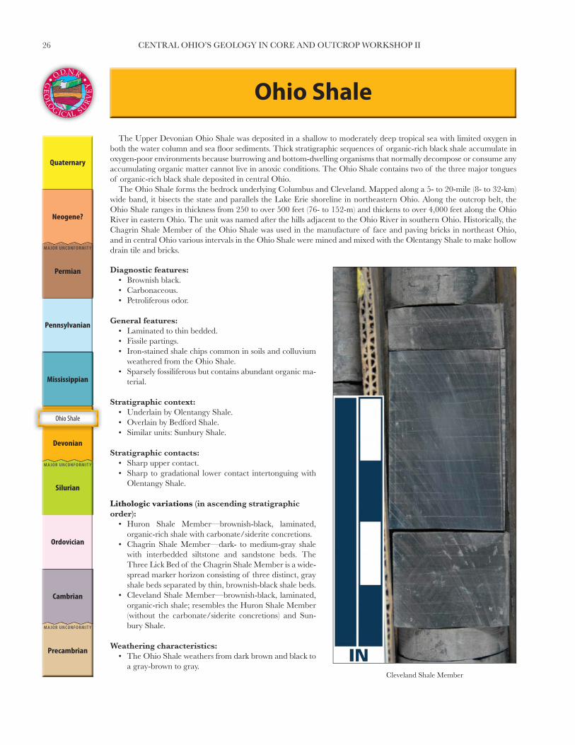
Ohio Shale
The Upper Devonian Ohio Shale was deposited in a shallow to moderately deep tropical sea with limited oxygen in both the water column and sea fl oor sediments. Thick stratigraphic sequences of organic-rich black shale accumulate in oxygen-poor environments because burrowing and bottom-dwelling organisms that normally decompose or consume any accumulating organic matter cannot live in anoxic conditions. The Ohio Shale contains two of the three major tongues of organic-rich black shale deposited in central Ohio.
The Ohio Shale forms the bedrock underlying Columbus and Cleveland. Mapped along a 5- to 20-mile (8- to 32-km) wide band, it bisects the state and parallels the Lake Erie shoreline in northeastern Ohio. Along the outcrop belt, the Ohio Shale ranges in thickness from 250 to over 500 feet (76- to 152-m) and thickens to over 4,000 feet along the Ohio River in eastern Ohio. The unit was named after the hills adjacent to the Ohio River in southern Ohio. Historically, the Chagrin Shale Member of the Ohio Shale was used in the manufacture of face and paving bricks in northeast Ohio, and in central Ohio various intervals in the Ohio Shale were mined and mixed with the Olentangy Shale to make hollow drain tile and bricks.
Ohio Shale
Cleveland Shale Member
Diagnostic features:• Brownish black.• Carbonaceous.• Petroliferous odor.
General features:• Laminated to thin bedded.• Fissile partings.• Iron-stained shale chips common in soils and colluvium
weathered from the Ohio Shale.• Sparsely fossiliferous but contains abundant organic ma-
terial.
Stratigraphic context:• Underlain by Olentangy Shale.• Overlain by Bedford Shale.• Similar units: Sunbury Shale.
Stratigraphic contacts:• Sharp upper contact.• Sharp to gradational lower contact intertonguing with
Olentangy Shale.
Lithologic variations (in ascending stratigraphic order):
• Huron Shale Member—brownish-black, laminated, organic-rich shale with carbonate/siderite concretions.
• Chagrin Shale Member—dark- to medium-gray shale with interbedded siltstone and sandstone beds. The Three Lick Bed of the Chagrin Shale Member is a wide-spread marker horizon consisting of three distinct, gray shale beds separated by thin, brownish-black shale beds.
• Cleveland Shale Member—brownish-black, laminated, organic-rich shale; resembles the Huron Shale Member (without the carbonate/siderite concretions) and Sun-bury Shale.
Weathering characteristics:• The Ohio Shale weathers from dark brown and black to
a gray-brown to gray.

27CENTRAL OHIO’S GEOLOGY IN CORE AND OUTCROP WORKSHOP II
• High iron content in some beds result in rust colored ground-water and staining of household fi xtures.
• Repeated cycles of wetting/drying and freeze/thaw result in rapid break down of the shale.
• In rock cuts, weathered shale forms loose talus slopes.
Economic geology:• Natural gas source rock and reservoir in southeastern Ohio and
in the subsurface adjacent to the outcrop belt of central and northeastern Ohio.
• Potential source of petroleum.
Geologic hazards:• Organic-rich members of the Ohio Shale are combustible;
open burning near exposures of these members is discouraged.• The Ohio Shale is uranium-rich in Ohio and is a source of
radon. Radon is a naturally occurring, radioactive gas that migrates into buildings from uranium-rich rocks, glacial sedi-ments containing abundant pieces of uranium-rich rocks, and soils. Radon is a known cancer-causing agent.
Hydrogeologic properties:• Typically a poor aquifer; generally suitable for limited house-
hold or small farm use.• Average yield is 3 to 5 gpm with a maximum yield of roughly
10 gpm.• Yield predominantly comes from a combination of joints and
fractures as they intersect bedding planes.• Best yields are developed from the uppermost weathered por-
tion of the formation.• Wells may be drilled deeper in the formation to obtain addi-
tional borehole storage.
• High sulfi de and iron content may represent a water quality problem.
• For groundwater modeling purposes, this unit may be consid-ered a lower confi ning unit or boundary unit when compared to overlying sandstone and shale units.
• Aquifer rating ranges from 2 to 3.• Hydraulic conductivity is in the range of 1–100 gpd/ft2.
Engineering Properties:• Unconfi ned Compressive Strength—Slightly strong to strong.• Slake Durability—Good to very good.• Rippability—Non-rippable.
Chagrin Shale MemberHistoric exposures of the Ohio Shale along the banks of Alum Creek near the present-day bridge
for U.S. Route 36 over Alum Creek Lake.

28 CENTRAL OHIO’S GEOLOGY IN CORE AND OUTCROP WORKSHOP II
Olentangy Shale
In the Olentangy Shale, the gradual change from shale interbedded with fossiliferous limestone to shale interbedded with brownish-black, organic-rich shales illustrates a major transition in depositional environments—from carbonate de-position in tropical seas teeming with carbonate-shelled organisms to siliciclastic deposition in tropical seas favoring the accumulation of organic-rich sediments, because of low oxygen levels in the water column and bottom sediments.
The Olentangy is largely buried under Quaternary-age sediments along a narrow, north–south-oriented outcrop belt extending from the Lake Erie shoreline in Erie County, through central Ohio, southward to the Ohio River. River and stream exposures are the best places to examine the Olentangy, which was named for a large exposure along the Olen-tangy River just south of Delaware, Ohio. The Olentangy ranges in thickness from 20 to 55 feet (6 to 16.7 m). Historically, clay from the Olentangy was mined for use in manufacturing drainage tile and hollow bricks.
Diagnostic features:• Gray to greenish-gray clay.• Discontinuous beds and limestone nodules (lower portion).• Thin beds of brownish-gray to brown shale (upper portion).
Olentangy Shale
Type locality of the Olentangy Shale along the banks of the Olentangy River, south of Delaware, Ohio. The low hydraulic conductivity of the Olentangy is well illustrated by the line of springs and associated mineral deposits occurring along the contact with the overlying Ohio Shale.

29CENTRAL OHIO’S GEOLOGY IN CORE AND OUTCROP WORKSHOP II
General features:• Thin bedded.• Clayey shale.• Platy to fi ssile partings.• Disseminated pyrite.• Sparsely fossiliferous.
Stratigraphic context:• Underlain by Delaware Limestone.• Overlain by Ohio Shale.• Similar units: Bedford Shale.
Stratigraphic contacts:• Sharp to gradational upper contact.• Sharp lower contact.
Lithologic variations:• Characteristic limestone beds and nodules of the lower portion
are absent south of Delaware County.
Weathering characteristics:• Rapidly weathers to light-gray clay because of wetting/drying
and freeze/thaw cycles.• Forms relatively thick colluvium.
Hydrogeologic properties:• Typically poor aquifer with minimal yields; suitable for limited
household and small farm usage.• Average yield is 3 to 5 gpm, with a maximum of roughly 10
gpm.• Yields provided by a combination of joints and fractures as they
intersect bedding planes.• Due to soft, clayey nature, the weathered portion may or may
not be higher-yielding than unweathered portions.• For ground-water modeling, may be considered a lower confi n-
ing unit or boundary unit.• Olentangy and Ohio shales have similar hydrogeologic proper-
ties and may be mapped together.• Aquifer rating ranges from 2 to 3.• Hydraulic conductivity in the range of 1–100 gpd/ft2.
Engineering Properties:• Unconfi ned Compressive Strength—Weak to slightly strong.• Slake Durability—Very poor to poor.• Rippability—Moderately rippable to non-rippable.
30 CENTRAL OHIO’S GEOLOGY IN CORE AND OUTCROP WORKSHOP II
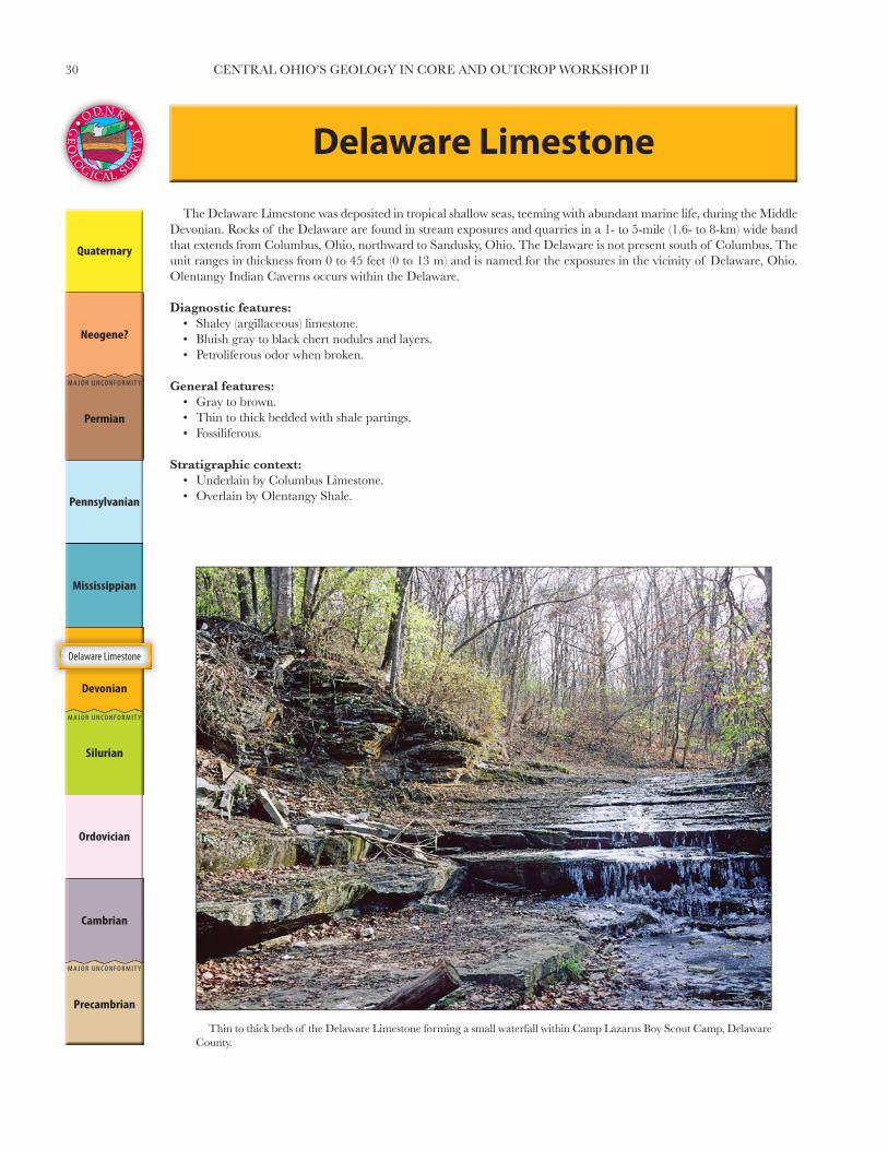
Delaware Limestone
The Delaware Limestone was deposited in tropical shallow seas, teeming with abundant marine life, during the Middle Devonian. Rocks of the Delaware are found in stream exposures and quarries in a 1- to 5-mile (1.6- to 8-km) wide band that extends from Columbus, Ohio, northward to Sandusky, Ohio. The Delaware is not present south of Columbus. The unit ranges in thickness from 0 to 45 feet (0 to 13 m) and is named for the exposures in the vicinity of Delaware, Ohio. Olentangy Indian Caverns occurs within the Delaware.
Diagnostic features:• Shaley (argillaceous) limestone.• Bluish gray to black chert nodules and layers.• Petroliferous odor when broken.
General features:• Gray to brown.• Thin to thick bedded with shale partings.• Fossiliferous.
Stratigraphic context:• Underlain by Columbus Limestone.• Overlain by Olentangy Shale.
Delaware Limestone
Thin to thick beds of the Delaware Limestone forming a small waterfall within Camp Lazarus Boy Scout Camp, Delaware County.

31CENTRAL OHIO’S GEOLOGY IN CORE AND OUTCROP WORKSHOP II
Stratigraphic contacts:• Sharp upper contact.• Sharp to gradational lower contact.
Weathering characteristics:• Weathers brown.• Produces blocks, slabs, or pebbles of limestone, common in
streams and glacial sediments.• Solution enlargement along joints.
Economic geology:• Quarried for over 100 years for dimension stone, crushed stone,
agricultural lime, Portland and asphaltic cements, and use in construction and road resurfacing.
Geologic hazards:• Dissolution of the Delaware can cause sinkholes or sudden col-
lapse of caves, resulting in land surface subsidence. If build-ings, roads, or bridges are built over these features, foundation failure may result in damage or destruction of such structures.
• Sinkholes provide the conduit for the rapid movement of sur-face water, potentially carrying sewage, animal wastes, and agricultural and industrial chemicals directly into the ground-water system. Rapid movement of pollutants into the ground-water system severely threatens potable water supplies.
Hydrogeologic properties:• Moderate aquifer capable of supplying domestic, most farm,
and small business needs.• Average yield for domestic wells in this aquifer range 10–25
gpm.• Yields from larger diameter wells intersecting fracture zones
are as high as 100 gpm.• Aquifer yield depends upon the abundance of fractures and
joints within a particular area.• In areas adjacent to modern streams and rivers, the Delaware
tends to have higher yields because the unit is highly fractured and receives higher recharge.
• Yields tend to decrease where the unit is covered by thick over-lying shale or glacial till, perhaps due to decreased recharge.
• The Delaware was evaluated as a massive limestone; aquifer ratings typically range 6–7.
• Hydraulic conductivity ranges from 100–300 gpd/ft2 to 300–700 gpd/ft2, depending upon fracturing.
Engineering Properties:• Unconfi ned Compressive Strength—Very strong.• Slake Durability—Very good.• Rippability—Non-rippable.

32 CENTRAL OHIO’S GEOLOGY IN CORE AND OUTCROP WORKSHOP II
Columbus Limestone
The Columbus Limestone was deposited in tropical, shallow seas, teeming with abundant marine life, which inundated Ohio during the Middle Devonian. The Columbus is exposed in stream exposures and quarries in a 1- to 5-mile (1.6- to 8-km) wide band extending from southern Pickaway County, along the Scioto River valley in the Columbus region, northward to Sandusky, Ohio. The unit ranges in thickness from 0 to 105 feet (0 to 32 m) and is named for the exposures in the Columbus region.
Diagnostic features:• Gray, fossiliferous limestone, upper 2⁄3 of unit.• Brown, fi nely crystalline dolomite, lower 1⁄3 of unit.
General features:• Fossiliferous limestone and dolomite.• Gray to brown.• Thick to massive bedding.• Finely to coarsely crystalline.• Occasional white to gray chert nodules.
Stratigraphic context:• Underlain by Salina Group.• Overlain by Delaware Limestone.
Stratigraphic contacts:• Sharp to gradational upper contact.• Sharp lower contact.
Lithologic variations:• Delhi Member and Bellepoint Member, central Ohio—The Delhi consists
of gray, fossiliferous limestone with some chert comprising the upper 2⁄3. The Bellepoint consists of brown, fi nely crystalline dolomite in thick to mas-sive beds.
• Venice Member and Marblehead Member, northern Ohio—The Venice is bluish-gray, argillaceous, fossiliferous, thick- to massive-bedded limestone; locally cherty. The Marblehead is gray to light-brown, fossiliferous lime-stone.
• In central Ohio, the base of the Bellepoint Member may contain a pebble conglomerate bed or locally developed quartz-rich sandstone.
Weathering characteristics:• The Columbus weathers to light gray or brown.• In natural exposures and road cuts, the Columbus forms cliffs and rocky,
steep slopes in areas of higher relief.• Abundant sinkholes present in upland areas with thin drift cover.• Subterranean caves and solution-enlarged joints occur locally.
Economic geology:• Quarried for over 200 years for dimension stone, crushed stone, agricultural
lime, Portland cement, asphaltic cement, and for use in construction and road resurfacing. The Statehouse in downtown Columbus and portions of many other buildings are constructed of the Delhi Member.
Scenic geology:• Ohio Caverns, Champaign County. Delhi Member
Columbus Limestone

33CENTRAL OHIO’S GEOLOGY IN CORE AND OUTCROP WORKSHOP II
• Zane Cavern, Logan County.• Seneca Caverns, Seneca County.• Hayden Falls along Scioto River, Columbus.
Geologic hazards:• Dissolution of the Columbus can result in sinkholes opening or sudden collapse of caves resulting in land
surface subsidence. If buildings, roads, or bridges are built over these features, foundation failure may result in damage or destruction of these structures.
• Sinkholes provide a conduit for rapid movement of surface water, potentially carrying sewage, animal wastes, and agricultural and industrial chemicals directly into the ground-water system. Rapid movement of these pollutants into the ground-water system poses a severe threat to potable water supplies.
Hydrogeologic properties:• Moderate to excellent aquifer capable of supplying domestic and farm needs.• Average yield for domestic wells completed in this aquifer range from 15 to 35 gpm.• Deeper, larger diameter wells produce yields that average from 100 to 500 gpm, making them suitable for
industrial, municipal, school, and major agricultural needs.• Yields exceeding 1,000 gpm have been reported from wells that intersect major solution-enlarged joint sets.• Recharge increases signifi cantly in vuggy intervals of the Columbus and areas with secondary solution along
fractures and joints, which also contributes to higher yields.• The Columbus is usually defi ned as a solution limestone and aquifer ratings range from 7 to 8.• The Columbus was evaluated as a karst limestone in northern Ohio, and aquifer ratings range from 9 to 10.• Hydraulic conductivity ranges from 700–1,000 gpd/ft2 to 1,000–2,000 gpd/ft2, depending upon degree of
solutioning and karst development.
Engineering Properties:Delhi Member• Unconfi ned Compressive Strength—strong to very strong.• Slake Durability—Very good.• Rippability—Non-rippable.
Bellepoint Member• Unconfi ned Compressive Strength—Moderately strong to very strong.• Slake Durability—Very good.• Rippability—Non-rippable.
Bellepoint Member
The contact between the lighter, thicker beds of the Columbus and the overlying darker, thinner beds of the Delaware is well illustrated in the high walls of Penry Quarry (Delaware County).

34 CENTRAL OHIO’S GEOLOGY IN CORE AND OUTCROP WORKSHOP II
Bedrock Geologic Map of Ohio
A
A'
WILLIAMS FULTON LUCAS
OTTAWA
WOOD
HENRY
DEFIANCE
HARDIN
HANCOCK
AUGLAIZE
ALLEN
PUTNAM
MERCER
VAN WERT
PAULDING
HOLMES
ERIESANDUSKY
SENECAHURON
LORAIN
MEDINA
WAYNEASHLANDRICHLANDCRAWFORD
MORROW
WYANDOT
MARIONCARROLL
STARK COLUMBIANA
MAHONING
TRUMBULL
PORTAGE
SUMMIT
GEAUGA
ASHTABULA
LAKE
CUYAHOGA
UNION
DELAWARE
KNOX
COSHOCTON
TUSCARAWAS
HARRISON
JEFFERSON
FAYETTE
PICKAWAY
FRANKLINMADISON
CLARK
MONTGOMERYPREBLE
CHAMPAIGNMIAMI
LOGANSHELBY
DARKE
BROWN
HIGHLAND
GREENE
CLINTONWARREN
CLERMONT
HAMILTON
BUTLER
BELMONTGUERNSEY
NOBLEMONROE
MUSKINGUM
MORGAN
WASHINGTON
LICKING
PERRYFAIRFIELD
HOCKING
ATHENS
MEIGS
VINTON
JACKSON
GALLIA
LAWRENCE
ROSS
PIKE
ADAMS
SCIOTO
GlacialMargin
A A'
0
0
10 20 30 40 miles
10 20 30 40 50 kilometers
Quaternary(cross section only)
Permian-Pennsylvanian
Pennsylvanian
Mississippian
Devonian
Silurian
Ordovician
Ordovician-Cambrian(cross section only)
Neoproterozoic(cross section only)
Mesoproterozoic(cross section only)
Fault
Key
Serpent MoundImpact Structure
Serpent MoundImpact Structure
APPALACHIAN BASIN
BELLEFONTAINEOUTLIERMICHIGAN BASIN
Glacial Margin
GRANITE-RHYOLITEPROVINCE
EAST CONTINENT RIFT BASIN GRENVILLE PROVINCE
Ben
d in
sect
ion
HIGHLAND
PIK
E
ADAMS
1 mi

35CENTRAL OHIO’S GEOLOGY IN CORE AND OUTCROP WORKSHOP II
This map is a generalization of the Bedrock Geologic Map of Ohio (Slucher and others, 2006)—the fi rst statewide 1:500,000-scale bedrock-geology map compiled by the Ohio Division of Geological Survey since 1920 and the fi rst to properly portray the bedrock geology that exists beneath the extensive deposits of Quaternary sediments that cover much of the bedrock in the state. Overall, the bedrock geology of Ohio consists of fl at lying to gently dipping carbonate, siliciclastic, evaporite, and organoclastic strata of sedimentary origin that range in age from Upper Ordovician to Upper Carboniferous-Lower Permian. At depth, as illustrated in the cross section, older sedimentary, igneous, and meta-morphic rocks that range from Lower Ordovician to Mesoproterozoic in age occur. At the surface, an irregular veneer of mainly unconsolidated Quaternary sediments conceal most bedrock units occurring northward and westward of the glacial margin.
Strata of the Ordovician System are the oldest exposed rocks in Ohio and consist mainly of alternating shale and limestone sequences. Silu-rian System strata are mostly dolomites with lesser amounts of shale. Rocks of the Devonian System consist of two contrasting types. Lower and Middle Devonian-age strata are mainly carbonate rocks whereas Upper Devonian-age rocks consist mostly of clastic rocks. In Cham-paign and Logan Counties, Devonian rocks occur on a small erosional remnant referred to as the Bellefontaine Outlier by geologists. Coinci-dentally, the highest topographic point in Ohio (Campbell Hill–1,549 feet above sea level) occurs also in this area.
The Carboniferous System is divided into two Subsystems, the Mississippian and Pennsylvanian. Mississippian strata are most-ly shales and sandstones that occur locally in various proportions. Pennsylvanian strata consist mainly of a diverse array of alternat-ing sandstones, siltstones, shales, mudstones, limestones, and under-clays; economic coal beds occur also in portions of this sequence. The youngest interval of sedimentary rocks in Ohio, the Dunkard Group, occurs only in southeastern Ohio and consists of strata similar in composition to the underlying Upper Pennsylvanian-age rocks; however, the age of the Dunkard Group has been debated since the late 1800s. Dunkard strata contain a well-studied late Penn-sylvanian-age assemblage of plant fossils with infrequent early Perm-ian-age forms. Yet, fossil plant spores found in coal beds in the interval only support a late, but not latest Pennsylvanian age. Thus, until more defi nitive fossils are found, geologist are unable to determine the exact age of the Dunkard Group beyond a combined Permian-Pennsylvanian age assignment.
In west-central Ohio, the ancient Teays River system extended across much of Ohio during the late Neogene to early Quaternary Periods and sculptured an extensive network of deeply dissected valleys into the bed-rock surface. The spatial confi guration of many geologic units on this map clearly refl ects the major channel networks of these former drainage systems. Also, four major regional structural geology elements affect the spatial distribution of rocks in Ohio: the Appalachian and Michigan ba-sins, and the Cincinnati and Findlay arches which occur between the two basins. Locally, several high-angle normal faults displace rocks in the state.
The Serpent Mound Impact Structure in southern Ohio is a circular area of deformed and broken rocks that is approximately four and one-half miles in diameter. Recent investigations indicate the feature is the result of a meteorite impact believed to have occurred between 256 and 330 million years ago.
Cross section A-A' traverses Ohio from the northwest to the southeast and intersects the southern portion of the Michigan Basin, the area be-tween the Cincinnati and Findlay arches, and the western Appalachian Basin, respectively. The stratigraphic units shown in this profi le illustrate the broad, arching geometric distortion to the bedrock in Ohio created mainly by periods of tectonic subsidence within these regional structural basins. For specifi c details on the various rock units, economic commodi-ties, and geologic hazards within Ohio, see either the printed or digital version of the Bedrock Geologic Map of Ohio (Slucher and others, 2006).
Quaternary (about 1.8 million years ago to present)—Uncon-solidated sediments: till, gravel, sand, silt, clay, and organic debris. Continental origin. (Shown in cross section only)
Period of widespread erosion
Permian and Pennsylvanian (about 298 to 302 million years ago)—Sedimentary rocks: mainly shale, sandstone, siltstone, mudstone, and minor coal. Continental origin.
Pennsylvanian (about 302 to 307 million years ago) Sedimenta-ry rocks: mainly shale, sandstone, siltstone, mudstone, limestone, and some coal. Continental and marine origin.
Pennsylvanian (about 307 to 318 million years ago)—Sedimen-tary rocks: mainly sandstone, siltstone, shale, and conglomerate, with some coal and limestone. Deltaic and marine origin.
Period of widespread erosion
Mississippian (about 322 to 359 million years ago)—Sedimen-tary rocks: sandstone, shale, siltstone, conglomerate, and minor limestone. Marine to marginal marine origin.
Devonian (about 359 to 385 million years ago)—Sedimentary rocks: mainly shale and siltstone with some sandstone. Marine to marginal marine origin.
Devonian (about 385 to 407 million years ago)—Sedimentary rocks: mainly limestone and dolomite with some shale, and minor sandstone. Marine and eolian origin.
Period of widespread erosion
Silurian (about 416 to 423 million years ago)—Sedimentary rocks: dolomite, anhydrite, gypsum, salt, and shale. Marine and restricted marine origin.
Silurian (about 423 to 435 million years ago)—Sedimentary rocks: dolomite and shale with some limestone. Marine origin.
Period of widespread erosion
Ordovician (about 446 to 450 million years ago)—Sedimentary rocks: shale and limestone. Marine origin.
Ordovician (about 450 to 460 million years ago)—Sedimentary rocks: limestone and shale. Marine origin.
Period of widespread erosion
Ordovician and Cambrian (about 486 to 510 million years ago)—Sedimentary rocks: mainly dolomite, sandstone, shale, with minor limestone. Marine origin. (Shown in cross section only)
Period of widespread erosion
Neoproterozoic (between 900 million and 1 billion years ago)—Metamorphic rocks: gneiss, schist, amphibolite, and marble; and igneous rocks: granite. Form during collision of tectonic plates. (Shown in cross section only)
Mesoproterozoic (between 1.0 and 1.2 billion years ago)—Sedimentary rocks: sandstone and siltstone; and igneous rocks: basalt and rhyolite. Form during rifting of continental landmass. (Shown in cross section only)
Period of widespread erosion
Mesoproterozoic (between 1.45 and 1.52 billion years ago)—Igneous rocks: granite and rhyolite. Formed during crustal evolu-tion and differentiation. (Shown in cross section only)

36 CENTRAL OHIO’S GEOLOGY IN CORE AND OUTCROP WORKSHOP II
�
�
�� �� �� ������
�� �� �� �� ����������
����������������
�������
������������
����
������
�������������
���!���"������������
�������������
���!���"������������
#����!�$�������
�������������
%���&�����"������������
'�"��������
������������� ������� �����������
���������� � ����� � �����������
�������������������� �!�� � �������
%(��()*+ ,-�.�/ �-�)+
�..)%)
%��
#0/'1
0,()/�0
#)' (/
#)/����
)-��)(20
)��0/
�-./)*
*0'�0'
3)/�%0'.
�)-� (/�
#��*0+
0'(0+)/ -+�1
+0/0�)#-'�/
��')(/
*0 (/)
%)1/0)+#�)/ '(�#�)/ �')%,�'
*�''�%
%1)/ �.
*)'(�/�)''���
+.)'� ���-*4()/)
*)#�/(/�
.'-*4-��
��'.)�0
+-**(.
�0)-�)
)+#.)4-�)
�)�0
�-1)#��)
-/(�/
0�)%)'0
�/�5
��+#��.�/
.-+�)')%)+
#)''(+�/
60,,0'+�/
,)10..0
�(��)%)1
,')/��(/*) (+�/
��)'�
*�/.��*0'1�'04�0
�#)*�)(�/*()*(
���)/
+#0�41
)'�0
4'�%/
#(�#�)/
�'00/0
��(/.�/%)''0/
��0'*�/.#)*(�.�/
4-.�0'
40�*�/.�-0'/+01
/�4�0
*�/'�0
*-+�(/�-*
*�'�)/
%)+#(/�.�/
�(��(/�
�0''1,)(',(0�
#���(/�
).#0/+
*0(�+
3(/.�/
6)��+�/
�)��()
�)%'0/�0
'�++
�(�0
) )*+
+�(�.�
Glacial Map of Ohio

37CENTRAL OHIO’S GEOLOGY IN CORE AND OUTCROP WORKSHOP II
Although diffi cult to imagine, Ohio has at various times in the re-cent geologic past (within the last 1.6 million years) had three-quar-ters of its surface covered by vast sheets of ice perhaps as much as 1 mile thick. This period of geologic history is referred to as the Pleis-tocene Epoch or, more commonly, the Ice Age, although there is abundant evidence that Earth has experienced numerous other “ice ages” throughout its 4.6 billion years of existence.
Ice Age glaciers invading Ohio formed in central Canada in re-sponse to climatic conditions that allowed massive buildups of ice. Because of their great thickness, these ice masses fl owed under their own weight and ultimately moved south as far as northern Ken-tucky. Oxygen-isotope analysis of deep-sea sediments indicates that more than a dozen glaciations occurred during the Pleistocene. Por-tions of Ohio were covered by the last two glaciations, known as the Wisconsinan (the most recent) and the Illinoian (older), and by an undetermined number of pre-Illinoian glaciations.
Because each major advance covered deposits left by the previ-ous ice sheets, pre-Illinoian deposits are exposed only in extreme southwestern Ohio in the vicinity of Cincinnati. Although the Il-linoian ice sheet covered the largest area of Ohio, its deposits are at the surface only in a narrow band from Cincinnati northeast to the Ohio-Pennsylvania border. Most features shown on the map of glacial deposits of Ohio are the result of the most recent or Wiscon-sinan-age glaciers.
The material left by the ice sheets consists of mixtures of clay, sand, gravel, and boulders in various types of deposits of different modes of origin. Rock debris carried along by the glacier was de-posited in two principal fashions, either directly by the ice or by meltwater from the glacier. Some material reaching the ice front was carried away by streams of meltwater to form outwash deposits. Material deposited by water on and under the surface of the glacier itself formed features called kames and eskers, which are recognized by characteristic shapes and composition. A distinctive character-istic of glacial sediments that have been deposited by water is that the material was sorted by the water that carried it. Thus, outwash, kame, and esker deposits normally consist of sand and gravel. The large boulder-size particles were left behind and the smaller clay-size particles were carried far away, leaving the intermediate gravel- and sand-size material along the stream courses.
Material deposited directly from the ice was not sorted and ranges
from clay to boulders. Some of the debris was deposited as ridges parallel to the edge of the glacier, forming terminal or end moraines, which mark the position of the ice when it paused for a period of time, possibly a few hundred years. When the entire ice sheet re-ceded because of melting, much of the ground-up rock material still held in the ice was deposited on the surface as ground moraine. The oldest morainic deposits in Ohio are of Illinoian and pre-Il-linoian age. Erosion has signifi cantly reduced these deposits along the glacial boundary, leaving only isolated remnants that have been mapped as dissected ground moraine and hummocky moraine.
Many glacial lakes were formed in Ohio during the Ice Age. Lake deposits are primarily fi ne-grained clay- and silt-size sedi-ments. The most extensive area of lake deposits is in northern Ohio bordering Lake Erie. These deposits, and adjacent areas of wave-planed ground moraine, are the result of sedimentation and erosion by large lakes that occupied the Erie basin as Wisconsin-an-age ice retreated into Canada. Other lake deposits accumulated in stream valleys whose outlets were temporarily dammed by ice or outwash. Many outwash-dammed lake deposits are present in southeastern Ohio far beyond the glacial boundary. Peat deposits are associated with many lake deposits and formed through the ac-cumulation of partially decayed aquatic vegetation in oxygen-de-pleted, stagnant water.
The term glacial drift commonly is used to refer to any material deposited directly (e.g., ground moraine) or indirectly (e.g., outwash) by a glacier. Because the ice that invaded Ohio came from Canada, it carried in many rock types not found in Ohio. Pebbles, cobbles, and boulders of these foreign rock types are called erratics. Rock col-lecting in areas of glacial drift may yield granite, gneiss, trace quanti-ties of gold, and very rarely, diamonds. Most rocks found in glacial deposits, however, are types native to Ohio.
Certain deposits left behind by the ice are of economic impor-tance, particularly sand and gravel, clay, and peat. Sand and gravel that have been sorted by meltwater generally occur as kames or es-kers or as outwash along major drainageways. Sand and gravel are vital to Ohio’s construction industry. Futhermore, outwash deposits are among the state’s most productive sources of ground water.
Glacial clay is used in cement and for common clay products (par-ticularly brick). The minor quantities of peat produced in the state are used mainly for mulch and soil conditioning.
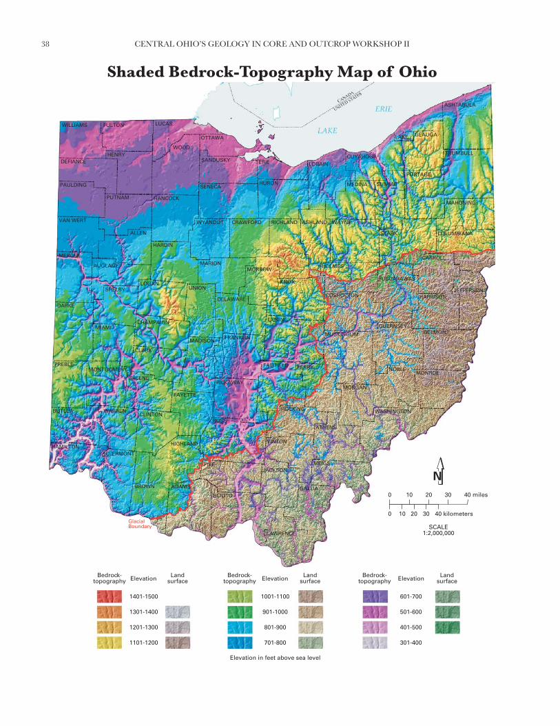
38 CENTRAL OHIO’S GEOLOGY IN CORE AND OUTCROP WORKSHOP II
����&� ��
����&����
����&����
����&����
����&����
7��&����
8��&7��
9��&8��
:��&9��
��&:��
���& ��
���&���
��!�4������$
4����!�&����"����$
4����!�&����"����$
4����!�&����"����$
�������;�!�
�������;�!�
�������;�!�0������
0���������;�����<�����������
0������ 0������
+�)�0�=�>���>���
������
�����������
� �� �� ��
� �� �� ��
%(��()*+ ,-�.�/ �-�)+
�..)%)
%�� #0/'1
0,()/�0
#)' (/
#)/����
)-��)(20
)��0/
�-./)*
*0'�0'
3)/�%0'.
�)-� (/�
#��*0+
0'(0+)/ -+�1
+0/0�)#-'�/
��')(/
*0 (/)
%)1/0)+#�)/ '(�#�)/ �')%,�'
*�''�%
%1)/ �.
*)'(�/�)''���
+.)'� ���-*4()/)
*)#�/(/�
.'-*4-��
��'.)�0
+-**(.
�0)-�)
)+#.)4-�)
�)�0
�-1)#��)
-/(�/
0�)%)'0
�/�5
��+#��.�/
.-+�)')%)+
#)''(+�/60,,0'+�/
,)10..0
�(��)%)1
,')/��(/*) (+�/
��)'�
*�/.��*0'1�'04�0
�#)*�)(�/*()*(
���)/+#0�41
)'�0
4'�%/
#(�#�)/
�'00/0
��(/.�/%)''0/
��0'*�/.#)*(�.�/
4-.�0'
40�*�/.�-0'/+01
/�4�0*�/'�0
*-+�(/�-*
*�'�)/
%)+#(/�.�/
�(��(/�
�0''1,)(',(0�
#���(/�
).#0/+
*0(�+
3(/.�/
6)��+�/
�)��()
�)%'0/�0
'�++
�(�0
) )*+
+�(�.�
Shaded Bedrock-Topography Map of Ohio

39CENTRAL OHIO’S GEOLOGY IN CORE AND OUTCROP WORKSHOP II
FIGURE 1.—Shaded elevation map of Ohio with the glacial boundary. Note the smooth landscape of glaciated northern and western Ohio com-pared to the high-relief landscape of unglaciated southeastern Ohio.
FIGURE 2.—Bedrock-topography map of Ohio showing the extent of the main Teays valley, the unglaciated portion of the state, and the ice-scoured and water-eroded portions of glaciated Ohio (C = Circleville,W = Wheelersburg).
GlacialBoundary
GlacialBoundary
The shaded bedrock-topography map of Ohio depicts the confi guration and elevation of the bedrock surface. In southeastern Ohio, the bedrock surface coincides with present-day land-surface topography and is depicted by earth-tone hues to represent elevation intervals. In glaciated western and northern Ohio, the bedrock surface is buried under mainly glacial sediments that can be several-hundred-feet thick. The land surface in this region was smoothed by glaciation (fi gure 1) and masks a complexly dissected, underly-ing bedrock surface. This dissected bedrock surface is the result of erosion before, during, and after glaciation. Spectral hues depict elevation intervals on the buried-bedrock surface and show the bedrock surface as if the overly-ing glacial sediment were removed.
Prior to and during glaciation, the north-fl owing Teays River system dom-inated surface-water drainage patterns in western and southern Ohio (fi gure 2). Water fl ow direction in the main Teays valley was north from Wheelers-burg (Scioto County) to Circleville (Pickaway County) and then northwest to Mercer County where the Teays Valley exited the state. Remnants of the Teays Valley are distinct on the present land surface in southern Ohio and form a continuous valley on the buried-bedrock surface across western Ohio. Modern rivers and streams still occupy portions of this valley system. Water fl ow in the Teays River system was disrupted by early glaciations as south-ward-advancing glaciers blocked outlets of the north-fl owing river system. Drainageways, both large and small, were abandoned or fi lled with sediment as ice advanced and retreated.
In northwestern Ohio, the generally smooth buried-bedrock surface is the result of repeated scouring by glacial ice advancing westward out of the Lake Erie basin. Another distinctly scoured bedrock surface is in the Grand River Lobe (fi gure 2) in northeastern Ohio where smooth north-south trending valleys mirror ice-fl ow direction. South of the scour-dominated surface of northern Ohio, the bedrock surface has been sculpted by water to create a distinct drainage pattern (fi gure 2). Large volumes of glacial meltwater eroded the bedrock surface, widening and deepening existing valleys of the Teays system and creating new valleys. Some modern rivers and creeks fl ow in unusually wide valleys; evidence that far greater volumes of water gener-ated from melting glaciers once fl owed in these valleys. Flow direction in other valleys has been reversed as glacial ice or glacial sediments blocked formerly northward and westward fl owing streams.
Southeastern Ohio is unglaciated and devoid of ice-deposited sediment (glacial till). However, many river valleys in southeast Ohio did carry glacial meltwater away from the ice front and toward the Ohio River. In the process, many of these valleys were at times made deeper by the erosive force of fast-fl owing meltwater streams, and at other times partially fi lled with sediment. Some valleys in unglaciated Ohio contain thick deposits of clay and silt that accumulated on the bottoms of lakes that formed when glacial ice blocked the fl ow of rivers or when rapidly accumulating meltwater sediments blocked the mouths of rivers.
This map is one of the results of a 7-year effort by the ODNR, Divi-sion of Geological Survey to map the bedrock geology of Ohio. Bedrock-topography maps are essential to producing accurate bedrock-geology maps of glaciated Ohio and of partially buried valleys beyond the glacial limit. Bedrock-topography maps were created for all 788 7.5-minute topographic quadrangles in the state and are available from the Division’s Geologic Re-cords Center. Some pre-existing county bedrock-topography maps (1:62,500 scale) and data were photographically enlarged to 1:24,000 scale, revised, and utilized in the compilation of 1:24,000-scale, bedrock-topography maps. Data concentration and contour intervals on the original maps vary widely across the state in response to changing geologic and topographic conditions. Data consists mainly of water-well logs on fi le at the ODNR, Division of Water, supplemented by outcrop data, Ohio Department of Transportation bridge-boring data, and oil-and-gas-well data.
Elevation contours and over 158,000 data points from the 788 bedrock-topography maps were digitized and compiled for the glaciated portions of the state and for the major valleys beyond the glacial boundary containing signifi cant accumulations of sediment deposited during and after glaciation. The bedrock-topography contours were digitally converted in the ARC GIS environment into a continuous grid model (60 meter grid spacing). This sur-face was shaded from the northwest slightly above the horizon to produce the appearance of a three-dimensional surface.
The land surface represents the topography of the bedrock surface in southeastern Ohio (excluding valleys beyond the glacial boundary) and in some glaciated areas near the glacial limit where meltwater sediments are thin or absent. Land-surface topography is based largely on data derived from the U.S. Geological Survey’s National Elevation Dataset (30 meter grid spacing).

40 CENTRAL OHIO’S GEOLOGY IN CORE AND OUTCROP WORKSHOP II
0
0
10 20 30 40 miles
10 20 30 40 50 kilometers
Silurian- and Devonian-age carbonate bedrock overlain by less than 20 feet of glacial drift and/or alluvium
Silurian- and Devonian-age carbonate bedrock overlain by more than 20 feet of glacial drift and/or alluvium
Interbedded Ordovician-age limestone and shale overlain by less than 20 feet of glacial drift and/or alluvium
Interbedded Ordovician-age limestone and shale overlain by more than 20 feet of glacial drift and/or alluvium
Probable karst areas
WisconsinanGlacial Margin
IllinoianGlacial Margin
Area not known tocontain karst features
EXPLANATION
MUSKINGUM
WILLIAMS
DEFIANCE
PAULDING
VAN WERT
MERCER
DARKE
MIAMI
PREBLE
BUTLER
HAMILTON
CLERMONT
PIKE
HIGHLAND
CLINTON
ROSS
GREENE
FAYETTE
CLARK
MADISON
CHAMPAIGN
LOGAN
HARDIN
MARION
HANCOCK
WYANDOT
WOODSANDUSKY
LUCAS
OTTAWA
ERIE
HURONSENECA
CRAWFORD RICHL AND
MORROW
KNOX
DELAWARE
PICKAWAY
SCIOTO
LAWRENCE
GALLIA
VINTON
PERRY
HOCKING
FAIRFIELD
LICKING
HOLMES
COSHOCTON
LORAIN
MEDINA
CUYAHOGA
GEAUGA
SUMMIT
PORTAGE
WAYNE
STARK
TUSCARAWAS
GUERNSEY
HARRISON
BELMONT
MORGAN
ATHENS
NOBLE
JEFFERSON
COLUMBIANA
MAHONING
TRUMBULL
LAKE
FULTON
HENRY
PUTNAM
ALLEN
AUGLAIZE
SHELBY
WARREN
BROWN ADAMS
UNION
JACKSONMEIGS
CARROLL
MONROE
WASHINGTON
ASHTABULA
MONTGOMERY
ASHLAND
FRANKLIN
Known and Probable Karst in Ohio

41CENTRAL OHIO’S GEOLOGY IN CORE AND OUTCROP WORKSHOP II
Karst is a landform that develops on or in limestone, dolomite, or gyp-sum by dissolution and that is characterized by the presence of character-istic features such as sinkholes, underground (or internal) drainage through solution-enlarged fractures (joints), and caves. While karst landforms and features are commonly striking in appearance and host to some of Ohio’s rarest fauna, they also can be a signifi cant geologic hazard. Sudden collapse of an underground cavern or opening of a sinkhole can cause surface subsid-ence that can severely damage or destroy any overlying structure such as a building, bridge, or highway. Improperly backfi lled sinkholes are prone to both gradual and sudden subsidence, and similarly threaten overlying struc-tures. Sewage, animal wastes, and agricultural, industrial, and ice-control chemicals entering sinkholes as surface drainage are conducted directly and quickly into the ground-water system, thereby posing a severe threat to po-table water supplies. Because of such risks, many of the nation’s state geo-logical surveys, and the U.S. Geological Survey, are actively mapping and characterizing the nation’s karst regions.
The fi ve most signifi cant Ohio karst regions are described below.
BELLEVUE-CASTALIA KARST PLAIN
The Bellevue-Castalia Karst Plain occupies portions of northeastern Sen-eca County, northwestern Huron County, southeastern Sandusky Coun-ty, and western Erie County. Adjacent karst terrain in portions of Ottawa County, including the Marblehead Peninsula, Catawba Island, and the Bass Islands, is related in geologic origin to the Bellevue-Castalia Karst Plain. The area is underlain by up to 175 feet of Devonian carbonates (Delaware Lime-stone, Columbus Limestone, Lucas Dolomite, and Amherstburg Dolomite) overlying Silurian dolomite, anhydrite, and gypsum of the Bass Islands Do-lomite and Salina Group.
The Bellevue-Castalia Karst Plain is believed to contain more sinkholes than any of Ohio’s other karst regions. Huge, irregularly shaped, closed de-pressions up to 270 acres in size and commonly enclosing smaller, circular-closed depressions 5 to 80 feet in diameter pockmark the land between the village of Flat Rock in northeastern Seneca County and Castalia in western Erie County. Surface drainage on the plain is very limited, and many of the streams which are present disappear into sinkholes called swallow holes.
Karst in the Bellevue-Castalia and Lake Erie islands region is due to col-lapse of overlying carbonate rocks into voids created by the dissolution and removal of underlying gypsum beds. According to Verber and Stansbery (1953, Ohio Journal of Science), ground water is introduced into Salina Group anhydrite (CaSO4) through pores and fractures in the overlying car-bonates. The anhydrite chemically reacts with the water to form gypsum (CaSO4•2H2O), undergoing a 33 to 62 percent increase in volume in the process. This swelling lifts overlying strata, thereby opening fractures and creating massive passageways for conduction of greater volumes of ground water through the Silurian Bass Islands Dolomite and into underlying Salina Group strata. Gypsum, being readily soluble in water, is dissolved, creat-ing huge voids. Overlying carbonates then collapse or break down, leaving surface depressions similar to those resulting from roof failure of an under-ground mine.
DISSECTED NIAGARA ESCARPMENT
The dissected Niagara Escarpment of southwestern Ohio includes the larg-est single area of karst terrain in the state and the greatest number of surveyed caves. It also is estimated to include the second-largest number of sinkholes in the state. The area is underlain by Silurian rocks of the Peebles Dolo-mite, Lilley Formation, Bisher Formation, Estill Shale, and Noland Forma-tion in Adams, Highland, and Clinton Counties and the Cedarville Dolomite, Springfi eld Dolomite, Euphemia Dolomite, Massie Shale, Laurel Dolomite, Osgood Shale, and Dayton Formation in Greene, Clark, Miami, Montgom-ery, and Preble Counties. The Peebles-Lilley-Bisher sequence and the Cedar-ville-Springfi eld-Euphemia sequence constitute the Lockport Group.
Most karst features along the Niagara Escarpment in southwestern Ohio are developed in Lockport Group strata. More than 100 sinkholes and caves developed in the Lockport have been documented in the fi eld, and more than 1,000 probable sinkholes in the Lockport have been identifi ed on aerial photographs, soils maps, and topographic maps. As with most karst terrain,
sinkholes developed on the Niagara Escarpment commonly show linear ori-entations aligned with prevailing joint trends in the area. The greatest con-centration of sinkholes on the escarpment is south of the Wisconsinan glacial border in southern Highland and Adams Counties, where highly dissected ridges capped by Silurian carbonate rocks rise 150 to 200 feet above sur-rounding drainage. Illinoian till in these areas is thin to absent, and soils are completely leached with respect to calcium and calcium-magnesium carbon-ate. Such geologic settings are ideal for active karst processes, as downward-percolating, naturally acidic rain water is not buffered until it has dissolved some of the underlying carbonate bedrock. Other signifi cant karst features of the Niagara Escarpment include small caves in escarpment re-entrants creat-ed by the valleys of the Great Miami and Stillwater Rivers in Miami County.
BELLEFONTAINE OUTLIER
The Bellefontaine Outlier in Logan and northern Champaign Counties is an erosionally resistant “island” of Devonian carbonates capped by Ohio Shale and surrounded by a “sea” of Silurian strata. Though completely gla-ciated, the outlier was such an impediment to Ice Age glaciers that it repeat-edly separated advancing ice sheets into two glacial lobes—the Miami Lobe on the west and the Scioto Lobe on the east. Most Ohioans recognize the outlier as the location of Campbell Hill—the highest point in the state at an elevation of 1,549 feet above mean sea level.
Although it is not known for having an especially well-developed karst ter-rain, the outlier is the location of Ohio’s largest known cave, Ohio Caverns. The greatest sinkhole concentrations are present in McArthur and Rush-creek Townships of Logan County, where the density of sinkholes in some areas approaches 30 per square mile. Sinkholes here typically occur in up-land areas of Devonian Lucas Dolomite or Columbus Limestone that are 30 to 50 feet or more above surrounding drainage and are covered by less than 20 feet of glacial drift and/or Ohio Shale.
SCIOTO AND OLENTANGY RIVER GORGES
The uplands adjacent to the gorges of the Scioto and Olentangy Rivers in northern Franklin and southern Delaware Counties include areas of well-de-veloped, active karst terrain. These uplands also are among the most rapidly developing areas of the state, which means karst should be a consideration in site assessments for commercial and residential construction projects.
The Scioto River in this area has been incised to a depth of 50 to 100 feet into underlying bedrock, creating a shallow gorge. The fl oor, walls, and adja-cent uplands of the gorge consist of Devonian Delaware and Columbus Lime-stones mantled by up to 20 feet of Wisconsinan till. Sinkhole concentrations up to 1 sinkhole per acre are not uncommon in Concord, Scioto, and Radnor Townships of Delaware County. The sinkholes range in diameter from about 10 to 100 feet and commonly are aligned linearly along major joint systems.
The Olentangy River is approximately 5 miles east of the Scioto River in southern Delaware County and occupies a gorge that is narrower and up to 50 feet deeper than the Scioto River gorge. The fl oor and the lower half of the walls along the Olentangy gorge are composed of Delaware and Colum-bus Limestones, the upper half of the walls is composed of Devonian Ohio and Olentangy Shales mantled by a thin veneer of glacial drift. Karst terrain has developed along portions of the gorge in a manner similar to karst terrain along the Scioto River.
ORDOVICIAN UPLANDS
The Ordovician uplands of southwestern Ohio are the location of surpris-ingly well-developed karst terrain despite the large component of shale in lo-cal bedrock. Numerous sinkholes are present in Ordovician rocks of Adams, Brown, Clermont, and Hamilton Counties.
The carbonate-rich members of the Grant Lake Formation (Bellevue and Mount Auburn), Grant Lake Limestone (Bellevue and Straight Creek), and the upper portion of the Arnheim formation are the Ordovician units most prone to karstifi cation; however, the shale-rich (70 percent shale, 30 percent limestone) Waynesville Formation also has been subjected to a surprising amount of karst development in southeastern Brown and southwestern Ad-ams Counties, just north of the Ohio River.

42 CENTRAL OHIO’S GEOLOGY IN CORE AND OUTCROP WORKSHOP II
���������
������������� ������� �������� ���������������������� ���������������������������������� ���������������� ��������� �������� ������������������� ������������������
�� �
!�"�
"!�#�
#!�! �
! !�!$�
!$!� !�
!!� $�
$!�%%�
%%!�&&�
&&!�' $
(������)������� *+,-.
!/ ��������
&�����
&������� ��
� !� � %�
� !� � %�
01--1,2* 34-�56 -4+,*
5��,0,
05578.69:
7.31,6+.
8,9716
8,6+5+;
,4(-,1<.
,--.6
=4�6,2
2.9+.9
>,60.9�
=,4-716(
85-2.*
.91.*,674*;:
*.6.+,84956
-59,16
2.716,
0,:6.,*8-,6791+8-,67+9,03597
259950
0:,675�
2,9156+,995--
*�,9; +5-42)1,6,
2,85616(
�942)4--
=59�,(.
*4221�
(.,4(,
,*8�,)4-,
-,;.
+4:,85(,
46156
7.-,0,9.
;65?
+5*85+�56
�4*+,9,0,*
8,991*[email protected]*56
3,:.��.
=1+;,0,:
39,6;-162,71*56
+-,9;
256�(52.9:=9.)-.
+8,2=,1(621,21
-5(,6*8.-):
7,9;.
)9506
81(8-,67
(9..6.
+-16�560,99.6
+-.9256�8,21-�56
)4�-.9
).-256�(4.96*.:
65)-.25695.
24*;16(42
259(,6
0,*816(�56
-1+;16(
=.99:3,1931.-7
85+;16(
,�8.6*
2.1(*
>16�56
@,+;*56
(,--1,
-,09.6+.
95**
=1;.
,7,2*
*+15�5
Shaded Drift-Thickness Map of Ohio

43CENTRAL OHIO’S GEOLOGY IN CORE AND OUTCROP WORKSHOP II
FIGURE 2.—Shaded elevation map of the land surface of Ohio with glacial boundary. Note the smooth landscape of glaciated northern and west-ern Ohio compared to the high-relief landscape of unglaciated southeastern Ohio (modifi ed from Powers, Laine, and Pavey, 2002).
FIGURE 1.—Shaded bedrock-topography map of Ohio showing the sculpted bedrock surface that lies beneath glacial drift in northern and west-ern Ohio and the land surface in unglaciated southeastern Ohio. Note the surface expression of the Teays Valley System south of the glacial bound-ary (arrow), the location of the main Teays Valley (between yellow dashed lines), the area of smooth bedrock topography, and the area of re-excavated preglacial bedrock valleys in northeastern Ohio. (W = Wheelersburg, C = Circleville, CH = Chillicothe) (modifi ed from Ohio Division of Geological Survey, 2003).
The drift-thickness map of Ohio depicts the thickness and distribu-tion of glacially derived sediments (called drift) and post-glacial stream sediments overlying the buried bedrock surface. This map was produced by subtracting bedrock-surface elevations from land-surface elevations to produce a residual map of drift thickness. Colors portray thickness in-tervals of glacial and modern sediments, which can range up to several hundred feet.
Prior to the onset of continental glaciation in the Early Pleistocene Epoch, approximately 1.8 million years before present, the Ohio land-scape was dominated by rolling hills and deeply incised, mature rivers and streams. A reduced version of the Division of Geological Survey’s Shad-ed-Bedrock Topography map of Ohio (fi g. 1) reveals some aspects of this old land surface. Erosion and deposition by Ice-Age continental glaciers advancing into northern and western Ohio produced a low-relief land surface compared to the unglaciated, high-relief land surface of south-eastern Ohio (fi g. 2). Comparing the shaded elevation map (fi g. 2) with the shaded bedrock-topography map (fi g. 1) reveals the dramatic impact of glaciation on the state’s current landscape.
Drift thickness in western and northern Ohio (fi g. 3) is highly variable, a consequence of numerous geologic factors acting in combination or alone. In some areas, drift has been deposited on a relatively fl at bedrock surface and changes in drift thickness are primarily the result of variations in the amount of glacial material deposited. In other areas, drift has in-fi lled a deeply incised buried-bedrock surface, and changes in drift thick-ness are primarily the result of variations in bedrock-surface elevation. In still other instances, the drift surface parallels the underlying bedrock surface to produce areas of relatively uniform drift thickness.
Distinct, narrow linear patterns of thick drift in western and central Ohio are the result of deep incisions in the underlying limestone and do-
lomite bedrock by a large, northwest fl owing drainage system, the Teays Valley system, that existed prior to and during early glaciations (fi g. 1). The main Teays Valley entered the state at Wheelersburg (Scioto County), where remnants of the Teays Valley are still evident on the modern land surface. At Chillicothe (Ross County), the valley disappears under gla-cial sediments which cover western Ohio. However, the valley continues north, below the surface, to Circleville (Pickaway County) and then north-west to Mercer County where the valley exits the state into Indiana. Early southward-advancing glaciers blocked the north-fl owing river system of the Teays and created immense lakes in southeastern Ohio.
In northeastern Ohio, narrow thick-drift areas south of Lake Erie were also preglacial bedrock valleys. These valleys were partially fi lled with thick deposits of till and glaciolacustrine (glacial lake) sediment and then re-excavated by later northward-fl owing rivers such as the Cuyahoga Riv-er and the East Branch of Rocky River.
In northwestern Ohio, repeated scouring of the relatively soft bed-rock surface by glacial ice fl owing southwestward from the Lake Erie Basin destroyed most pre-existing drainage systems. In this part of Ohio, the bedrock surface is smooth and the upper surface of the drift has been planed off by wave action and deposition by a post-glacial, high-level ancestral Lake Erie. In the extreme northwest corner of Ohio, in Wil-liams County and portions of Defi ance County, drift thickens consider-ably because of numerous moraines that formed along the northwestern edge of the Erie Lobe.
In western Ohio, draping linear features of thick drift, called ridge moraines, formed along the temporarily stationary ice-front as glacial sediment was released from the ice. These ribbons of thick drift defi ne the lateral dimensions of glacial ice lobes, particularly those of the last Wisconsinan ice sheet (fi gure 4). Many ridge moraines in western and northeastern Ohio have a draped appearance because south-fl owing ice, impeded by bedrock highlands, moved more easily along major lowlands. The numerous resistant bedrock highlands in northeastern Ohio caused ridge moraines to be especially arcuate and closely stacked.

44 CENTRAL OHIO’S GEOLOGY IN CORE AND OUTCROP WORKSHOP II
FIGURE 3.—Schematic cross section of glacial drift overlying the bedrock surface. Note areas where drift thickness is controlled by thickening of glacial sediment over a relatively fl at bedrock sur-face, by drift infi lling bedrock val-leys, or by fl uctuations in both the land surface and the bedrock sur-face. Also note areas where valleys in the buried-bedrock surface are not evident on the land surface.
FIGURE 4.—Glacial map of Ohio showing the distribution of glacial sediments and their relative ages. Note glaciated northern and western Ohio, unglaciated southeastern Ohio, and the position of ridge moraines and the lake deposits and wave-planed ground moraine of the Lake Erie Basin. Bed-rock highlands (BH) impeded the southward advance of glacial ice causing the moraines to form a lobate confi guration (modifi ed from Pavey and oth-ers, 1999).
;����������
5� ���
-��������
=��
+��������
(������������
0�����������������������
9�����������
������������� ������� �����������
(������������
7��� ���������������
8��������������
���������� � ����� � �����������
(������������
7��� ���������������
�������������������� �!�� � �������
��
��
��
-,67*493,+.
).795+;>,--.:
).795+;>,--.:
).795+;*493,+.
����� �����
����� ����
�
Southeastern Ohio is unglaciated and devoid of ice-deposited sedi-ment (glacial till). Many southeast Ohio valleys, however, carried huge volumes of glacial meltwater away from the ice front and toward the Ohio River. In the process, many of these valleys were at times made deeper by the erosive force of fast-fl owing meltwater streams, and at other times were partially fi lled with sediment. Some valleys in unglaci-ated Ohio contain thick deposits of clay and silt that accumulated on the bottoms of lakes that formed when glacial ice blocked the fl ow of rivers or when rapidly accumulating meltwater sediments blocked the mouths of smaller tributaries.
METHODS
Two digital data layers are required to generate the drift-thickness map: the surface-elevation layer and the bedrock-topography layer. Drift thick-ness is calculated by subtracting the bedrock-topography elevation from the land surface elevation. The bedrock-topography component is one of the products resulting from a multi-year effort by the ODNR, Division of Geological Survey to map the bedrock geology of Ohio. Bedrock-topog-raphy maps are required to determine the relief on the bedrock surface beneath thick layers of glacial drift. Bedrock-topography maps were cre-ated by the Division of Geological Survey for all 788 7½-minute topo-graphic quadrangles in the state as part of a process to produce accurate bedrock-geology maps for glaciated portions of Ohio and for those areas beyond the glacial boundary where valleys are infi lled with sediment. Data concentration and contour intervals on the original, hand-drawn bedrock-topography maps vary widely across the state in response to changing geo-logic and topographic conditions. These data consist mainly of water-well logs on fi le at the ODNR, Division of Water, supplemented by outcrop data, Ohio Department of Transportation bridge-boring data, and oil-and-gas-well data. During the course of mapping, over 162,000 data points were interpreted for bedrock-surface elevation and in some cases drift thickness. These points were plotted on maps and used as control for the bedrock-topography lines. Individual 24,000-scale bedrock-topog-raphy maps are available from the Division’s Geologic Records Center.
Elevation contours and data points from the 788 bedrock-topography maps were digitized and compiled for the glaciated portions of the state and for the valleys beyond the glacial boundary containing signifi cant accumulations of sediment deposited during and after glaciation. The bedrock-topography contours were digitally converted in an ArcGIS en-vironment to create a continuous grid model (60 meter grid spacing). A statewide compilation map and digital dataset of the bedrock topography of Ohio (modifi ed from Ohio Division of Geological Survey, 2003) are available from the Division of Geological Survey.
Uncolored areas of southeastern Ohio represent extensive portions of unglaciated Ohio where the land surface and the bedrock surface are es-sentially the same. On the original maps in these areas, bedrock-topogra-phy lines were restricted to the buried-valley portions of the map and were not drawn in upland portions.
The second component needed to create the drift-thickness map, the land-surface topography, is based largely on data derived from the U.S. Geo-
logical Survey’s National Elevation Dataset (30 meter grid spacing). These data have been modifi ed extensively by the Ohio Division of Geological Survey to replace some anomalous errors that are inherent in portions of the National Elevation Dataset. A statewide compilation map and digital dataset of the shaded elevation of Ohio (modifi ed from Powers, Laine, and Pavey, 2002) are available from the Division of Geological Survey.
A grid of the digitized bedrock-topography contours was subtracted from a grid of the land-surface Digital Elevation Model to derive a third grid (60 meter grid spacing) representing the thickness of the drift. This grid surface was shaded from the northwest, slightly above the horizon, to produce the appearance of a three-dimensional surface.

NOTES

CE
NT
RA
L O
HIO
'S G
EO
LOG
Y IN
CO
RE
AN
D O
UT
CR
OP
WO
RK
SH
OP
II—O
hio
Div
ision
of G
eo
log
ical S
urv
ey O
pe
n-F
ile R
ep
ort 2
011-1