Embed Size (px)
Citation preview

U.S. Department of the InteriorU.S. Geological Survey
Fact Sheet 2009–3011March 2009
Oil Shale Assessment Project Fact Sheet
Nahcolite Resources in the Green River Formation, Piceance Basin, Northwestern Colorado
Printed on recycled paper
IntroductionThe U.S. Geological Survey (USGS)
recently completed an assessment of in-place nahcolite (NaHCO3) resources in the Piceance Basin, northwestern Colo-rado (fig. 1). Nahcolite is present in the oil shale deposits of the Parachute Creek Member of the Eocene Green River Formation. It occurs as disseminated aggregates, nodules, bedded units of disseminated brown crystals, and white crystalline beds associated with dawson-ite (NaAl(OH)2CO3) and halite (NaCl). The nahcolite-bearing facies are divided into an unleached part containing the nahcolite and halite, which is estimated to be as much as 1,130 ft thick, and an upper leached part several hundred feet thick containing minor nahcolite aggre-gates and nodules. Locally, thick beds of halite and brown fine-grained nahcolite lie in the depocenter of the basin (figs. 1 and 2), but thin laterally away from the basin center and grade into beds of white, coarse-grained nahcolite. In the central part of the study area, the top of the nahcolite-bearing rocks range in depth from about 1,300 to 2,000 ft.
Dissolution of water-soluble miner-als, mostly nahcolite and halite, in the upper part of the nahcolite-bearing facies has created a collapsed leached zone as much as 580 ft thick that consists of laterally continuous units of solution breccia and fractured oil shale containing solution cavities. The top of the leached zone is not yet defined in the basin, but it probably extends into the A groove in the upper part of the Parachute Creek Member (fig. 2).
U sing a geology-based assessment methodology, the U.S. Geological Survey estimated an in-place resource of 43.3 billion short tons of nahcolite (sodium bicarbonate) in the oil shale deposits of the Parachute Creek Member of the Eocene Green River Formation in the Piceance Basin, northwestern Colorado. More than 69 percent, or 29.9 billion short tons, of the estimated nahcolite resource is found in the R–4, L–5, and R–5 oil shale zones.
108°00'108° 30'
40°00'
39° 30'
T 99 W T 98 W T 97 W T 96 W T 95 W
Colorado
Index map
0 12 MILES
70
Piceance
White River
White River
64
64
13
13
139
139Meeker
Rangely
Rifle
Rio Blanco
DeBeque
Parachute
City or town
Area underlain by oil shale rocks
EXPLANATION
County line
Core hole with nahcolite analyses
Colorad
o Rive
r
Creek
Creek
Par achute Creek
MESA
GARFIELDRIO BLANCO
Roan
Boundary of nahcolite- bearing zone
Boundary of saline zone— Includes dawsonite and halite
C0002
T. 2 N.
T. 1 N.
T. 1 S.
T. 2 S.
T. 3 S.
T. 4 S.
T. 5 S.
T. 8 S.
T. 7 S.
T. 6 S.
R. 100 W.R. 101 W. R. 99 W. R. 98 W. R. 97 W. R. 96 W.R. 102 W. R. 95 W. R. 94 W.
Figure 1. Map of northwestern Colorado showing locations of nahcolite-bearing core holes, the inferred boundaries of the nahcolite-bearing zone and saline zone of Pitman and others (1989), and generalized outcrops of the oil shale-bearing rocks in the Parachute Creek Member of the Eocene Green River Formation in the Piceance Basin.

The presence of nahcolite is a concern for the surface retorting and in-place oil shale processes because nahcolite decomposes to natrite (Na2CO3) or soda ash, carbon dioxide, and water at temperatures near 100°C during the two recovery processes. In addi-tion, nahcolite is considered a leasable mineral and thus must not be destroyed during processes used to recover oil from oil shale. Nahcolite is a potential
raw material for the manufacture of a variety of basic industrial chemicals (for example, baking soda), but the mineral has perhaps received more attention for its potential use in removing sulfur diox-ide from industrial stack gases. Because nahcolite seems to be a potentially valu-able coproduct of oil shale, it becomes important to know where and in what abundance it occurs in the oil shale.
MethodologyIn this assessment, a spatial inter-
polation and extrapolation method for generating resource maps and computing resource volumes was used—the Radial Basis Function (RBF) in ArcGIS GeoSta-tistical Analyst (Environmental Systems Research Institute, Inc. (ESRI), Redlands, Calif., 2006, v. 9.2).
The RBF method in GeoStatistical Analyst is an exact interpolator; it will honor all data points and not introduce errors at those locations. Where it is important for the modeling method to honor the measured values, RBF can also extrapolate values above or below the actual values away from the data point locations. The final resource models for each nahcolite-bearing zone were created using a sampling method containing ten moving window sectors with fifteen neighbors in each sector, except for the L–5 zone where the model was limited to ten neighbors or data points.
Although the RBF method does not generate as complete an error estimate as kriging, it does give the difference between the predicted and measured value for each control point, and it does give an overall difference value for an entire oil shale zone model. To obtain the differ-ence between the predicted value and the measured value, the RBF method predicts a value at a given control point from the nearest control points (in this assess-ment either 10 or 15) without knowing the actual value measured at that control point. That predicted value is then com-pared with the measured value, and the difference between the two is calculated.
Nahcolite resource models using weight-percent nahcolite data were created using the RBF, which interpo-lated (and extrapolated) surfaces using a multiquadratic gridding method. Once the models were created, we quanti-fied total tonnages of nahcolite by using ESRI Spatial Analyst’s Zonal Statistics function. That is, tonnages could be determined by township using the nahco-lite resource model (208.71 ft = 63.615-m cell size) and a township grid that had been clipped with an outcrop file derived from the base of the Mahogany zone of the Green River Formation for both the nahcolite resources in the oil shale zones and the total in-place nahcolite within the inferred extent of the nahcolite-bearing interval (figs. 1 and 3).
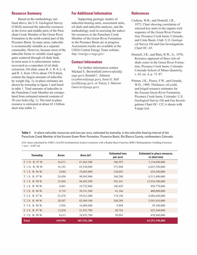
0 2020 4040 6060 8080 100100Oil in GPT; Nahcolite in wt. %
Wolf Ridge Minerals Corp.,Dunn 20–1, C0002
Sec 20 T. 1 S., R. 98 W.
1,500
2,000
2,500
R–3
L–3
R–4
L–4
R–5
Zone
DEP
TH
IN
FEET
A groove
Mahogany zone
B groove
Rich oil shalezone R–6
Rich oil shalezone R–5
Rich oil shalezone R–4
Rich oil shalezone R–1
Rich oil shalezone R–0
Rich oil shalezone R–3
Rich oil shalezone R–2
Stratigraphic nomenclature for oil shalezones (Donnell and Blair, 1970;
Cashion and Donnell, 1972)
Para
chut
e Cr
eek
Mem
ber i
n pa
rtGa
rden
Gul
chM
embe
r in
part
Gree
n Ri
ver F
orm
atio
n
Lean oil shale zone L-2
Lean oil shale zone L–1
Lean oil shale zone L–0
Lean oil shalezone L–4
Lean oil shale zone L-3
Lean oil shalezone L–5
EXPLANATION
Oil-yield histogram (in gallons per ton)
Saline bed (halite and nahcolite)
Nahcolite-rich bed
Nahcolite histogram (in weight percent)
Figure 2. Plot showing oil-yield (gallons per ton, GPT) and nahcolite (weight percent, wt. %) histograms and stratigraphic nomenclature for oil shale zones (Donnell and Blair, 1970; Cashion and Donnell, 1972) for the Wolf Ridge Minerals Corp., Dunn 20–1 core hole, north-central Piceance Basin, Colorado.
R 96 W R 95 W
R 101 W R 100 W R 99 W R 98 W R 97 W R 94 W
T8S
T7S
R 93 W
T6S
T5S
T4S
T3S
T9S
R 94 W
R 101 W R 100 W R 99 W R 98 W R 97 W
T2S
T1S
T1N
R 96 W R 95 W
T2N
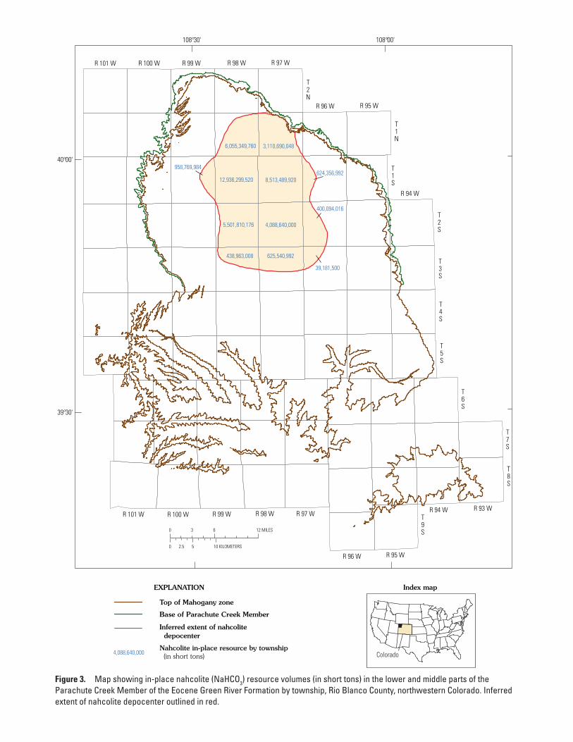
438,963,008 625,540,992
39,181,500
5,501,810,176 4,088,640,000
400,094,016
958,769,984
12,936,299,520 8,513,489,920624,356,992
6,055,349,760 3,110,690,048
108°00'108°30'
40°00'
39°30'
0 6 123 MILES
0 5 102.5 KILOMETERS
EXPLANATION
Top of Mahogany zone
Base of Parachute Creek Member
Inferred extent of nahcolite depocenter
Colorado
Index map
Nahcolite in-place resource by township (in short tons)4,088,640,000
Figure 3. Map showing in-place nahcolite (NaHCO3) resource volumes (in short tons) in the lower and middle parts of the Parachute Creek Member of the Eocene Green River Formation by township, Rio Blanco County, northwestern Colorado. Inferred extent of nahcolite depocenter outlined in red.
Resource SummaryBased on the methodology out-
lined above, the U.S. Geological Survey (USGS) assessed the nahcolite resources in the lower and middle parts of the Para-chute Creek Member of the Green River Formation in the north-central part of the Piceance Basin. In some areas, nahcolite is economically minable as a separate commodity. However, because most of the nahcolite forms in variable sized aggre-gates scattered through oil shale beds, in most areas it is subeconomic unless recovered as a coproduct of oil shale extraction. Oil shale zones R–3, R–4, L–4, and R–5, from 150 to about 370 ft thick, contain the largest amounts of nahcolite by weight (fig. 2); in-place estimates are shown by township in figure 3 and listed in table 1. Total amounts of nahcolite in the Parachute Creek Member are extrapo-lated from estimated mineral contents of 58 core holes (fig. 1). The total in-place resource is estimated at about 43.3 billion short tons (table 1).
For Additional InformationSupporting geologic studies of
nahcolite-bearing units, assessment units, oil shale and nahcolite analyses, and the methodology used in assessing the nahco-lite resources in the Parachute Creek Member of the Green River Formation in the Piceance Basin are in progress. Assessment results are available at the USGS Central Energy Team website: http://energy.cr.usgs.gov/.
Contact InformationFor further information contact
Michael E. Brownfield ([email protected]), Ronald C. Johnson ([email protected]), Jesse G. Self ([email protected]), or Tracey J. Mercier ([email protected]).
References
Cashion, W.B., and Donnell, J.R., 1972, Chart showing correlation of selected key units in the organic-rich sequence of the Green River Forma-tion, Piceance Creek basin, Colorado, and Uinta Basin, Utah: U.S. Geologi-cal Survey Oil and Gas Investigations Chart OC–65.
Donnell, J.R., and Blair, R.W., Jr., 1970, Resource appraisal of three rich oil shale zones in the Green River Forma-tion, Piceance Creek basin, Colorado: Colorado School of Mines Quarterly, v. 65, no. 4, p. 73–87.
Pitman, J.K., Pierce, F.W., and Grundy, W.D., 1989, Thickness, oil-yield, and kriged resource estimates for the Eocene Green River Formation, Piceance Creek basin, Colorado: U.S. Geological Survey Oil and Gas Investi-gations Chart OC–132, 6 sheets with 4-page text.
Table 1. In-place nahcolite resources and tons per acre, estimated by township, in the nahcolite-bearing interval of the Parachute Creek Member of the Eocene Green River Formation, Piceance Basin, Rio Blanco County, northwestern Colorado.
[All values calculated by ESRI’s ArcGIS GeoStatistical Analyst extension with a Radial Basis Function (RBF) Multiquadratic Gridding Function; 1 acre = 4,047 m]
Township Acres Area (m2)Estimated tons
per acreEstimated in-place resource,
in short tons
T. 1 N. R. 97 W. 16,671 67,465,300 186,593 3,110,690,000
T. 1 N. R. 98 W. 16,193 65,530,900 373,948 6,055,350,000
T. 1 S. R. 96 W. 4,844 19,603,000 128,893 624,360,000
T. 1 S. R. 97 W. 24,450 98,945,900 348,200 8,513,490,000
T. 1 S. R. 98 W. 23,844 96,493,500 542,541 12,936,300,000
T. 1 S. R. 99 W. 4,881 19,752,800 196,429 958,770,000
T. 2 S. R. 96 W. 9,719 39,331,500 41,166 400,090,000
T. 2 S. R. 97 W. 23,478 95,012,400 174,148 4,088,640,000
T. 2 S. R. 98 W. 20,507 82,989,100 268,289 5,501,810,000
T. 3 S. R. 96 W. 3,956 16,009,400 9,904 39,180,000
T. 3 S. R. 97 W. 12,838 51,953,700 48,726 625,540,000
T. 3 S. R. 98 W. 8,613 34,855,700 50,965 438,960,000
Total 169,994 687,943,200 43,293,190,000