Embed Size (px)
Citation preview
NBI No.:12833 Structure No.:55N3050E1020007 Local ID:O-250A
Bridge Inspection ReportOKLAHOMA DEPARTMENT OF TRANSPORTATION -Health Index :
64.9Suff. Rating: 49.0
SD
OKLA. CITY
46. No. of Approach Spans: 045. No. of Spans Main Unit:
STRUCTURE TYPE AND MATERIALS
4
106. Year Reconstructed:1952
7109. Truck ADT %:201430. Year of ADT:220005 Highway-pedestrian
1 Highway
29. ADT:42A. Type of Service on:
42B. Type of Service under:
27. Year Built:
AGE AND SERVICE
-4
5.0 ft55A/55B. Minimum Lateral Undrclearance R:
56. Minimum Lateral Undrclearance L:
NAVIGATION DATA
2 Intolerable - Replace
APPRAISAL
8 Equal Desirable Crit
5 Above Tolerable68. Deck Geometry:
H Hwy beneath struct 3.9 ft
4 Minimum Tolerable
N Not Over Waterway
67. Str. Evaluation:
69. Underclearance, Vertical and Horizontal:
72. Approach Alignment:
113. Scour Critical:
60. Sub.:
N N/A (NBI)
CONDITION
N N/A (NBI)
58. Deck:
62. Culvert:Flowline Notes:
5 Fair 5 Fair 7 Good
Unknown0% Resp. :Unknown (P)
NORTHWEST EXPY UNDER
35 31 39.78
OKLAHOMADivision 4
98. Border Br. Code:
6. Feature Intersected:
7. Facility Carried:
16. Latitude:
3. County Code: 4. Place Code:2. SHD District:
1 Concrete-Cast-in-Place
1 Monolithic Concrete
0 None
107. Deck Type:
108A. Wearing Surface:
108B. Membrane:
44. Approach Span Material and Design Type
43. Main Span Material and Design TypeSteel Stringer/Girder
Not Applicable (P) Not Applicable (P)
28A. Lanes on: 4 28B. Lanes Under: 6 19. Detour Length: 3.0 mi
NO FLOWLINE NORTHWEST EXPRESSWAY BELOW
1. State:Oklahoma
71. Waterway Adequacy: N Not applicable
Admin. Area: Unknown
Not Applicable (P) 0.0 ft0.0 ft 0.0 ft
111. Pier Protection:39. Vertical Clearance:
116. Lift Bridge Vert. Clear.:40. Horizontal Clearance:
97. Year of Cost Est.: 115. Year of Future ADT:
PROPOSED IMPROVEMENTS
96. Total Cost:
75. Type of Work:
76. Lgth. of Improvment:114. Future ADT:
2009
31 Repl-Load Capacity
248.4 ft35200
2034
IDENTIFICATION
5. Inventory Route (Route On Structure) :
13. LRS Inv. Route./ Subroute.: -1 -1
99. Border Br. #:17. Longitude: 097 33 57.39
59. Super.:
61. Channel/Channel Protection:
$4,622,635
94. Bridge Cost: $1,650,941
95. Roadway Cost: $2,724,053
36B. Transition: 0 Substandard
36A. Bridge Rail: 0 Substandard 36C. Approach Rail:
36D. Approach Rail Ends: 0 Substandard
0 Substandard
108C. Deck Protection: None
38. Navigation Control: NA-no waterway
Deck Area: 13,020. sq. ft
52.0 ft
4.0 ft
56.0 ft
GEOMETRIC DATA
32. Approach Roadway Width (W/ Shoulders):
48. Length Maximum Span:
50A. Curb/Sdwlk Wdth L:
51. Width Curb to Curb:
53. Minimum Vertical Clearance Over Bridge:
54A/54B. Min. Vert. Underclearance :
52.0 ft
186.0 ft4.0 ft
70.0 ft
328.1 ft
H Hwy beneath struct 14.4 ft
2 Closed Med w/o B
10. Inv. Rte. Min. Vert. Clr.: 328.1 ft
34. Skew: 18 0 No flare
47. Inv. Rte. Total Horiz. Clr.: 60.0 ft
33. Median:
35. Structure Flared:
49. Structure Length:
50B. Curb/Sidewalk Width R:
52. Width Out to Out:
N/E S/W
DO NOT U DO NOT U DO NOT U
E1411 Meas.
DO NOT U Post.
-1
DO NOT U
-1 W1407 -1
-1
-1
Description:37'-51'-51'-37' I-BM. SPANS WITH 2-4' SIDEWALKS SK. 72 DEG.45'
- -- 5 1 000001 0-
LOAD RATING AND POSTING
1 LF Load Factor-Ton
41. Posting status: A Open, no restriction
9/26/2012
Alt. Inv. Rating Meth.:
Date Rated :
Alt. Op. Rating Meth.: 1 LF Load Factor-To
70. Posting:
63. Op. Rating Method:
31. Design Load:
65. Inv. Rating Method:
4 M 18 (H 20)
1 LF Load Factor-Ton
64. Operating Rating (H / HS / 3-3 ):
66. Inventory Rating ( H / HS / 3-3 ) :
1 LF Load Factor-Ton
5 At/Above Legal Loads
35.0 50.0 85.5
21.0 30.0 51.2
9. Location: MAY AVE SEPARATION 11. Mile Post: 0.700 miMAY AVE. MAY AVE.
INSPECTION
Insp Done Freq: Insp. Date: Next Insp.: Insp Req. Type
200c. Temperature:
200d. Weather:
202. Waterproof Membrane :
Date Installed :
205. Material and Quantity :
208. Type of Abutment :
Type of Foundation :
209. Type of Pier / Found.: 5
204. Type of Handrail:
203. Type Exp. Dev. :
85
-1 -1201. Structural Steel ASTM Desig.:
-1
Cantilever
Natural Foundation Matl.
NoNo Piling or Drilled Shaft
15
-
Pourable
PARTLY CLOUDY
1/1/1901
-1.0
210. Foundation Elev.
-1.0
213. Utilities Attached :
211. Wear. Surf. Prot. System :Date Installed :
-1.0 -1.0
-1.0-1.0
None1/1/1901Power
-1
-1
-1
-1
-1
-1
221. Substructure Cond. (U/W) :
222. Fill over RCB:
224. Critical Feature Type:223. Appr. Slab/Rdwy Cond.:
Overcoat :225. Paint Type :
226. Date Painted:
-
-1
Satisfactory-1Red Lead Ready0
5201Silver
215. Overpass :
Advanced Warning Sign :
Exisiting/Recommended Posting :
Min./ Max Vert. Clearance :
Working/Not Working :
c. Narrow/One Lane Bridge sign :
d. Vertical Clearance Sign:
e. Navigation Lights :
214a. Posted Weight Limit: b. Posted Speed Limit :
A - ACOG (OKC Metro)
1408
35
YESN
NR
YES
1407_
1404
1411
_
227. Paint Coloring:
233. Deck Forming:236. Deck Cleaning :
Conventional Forming-1
238. School Bus Rte: Current and Desired Route
2:
4:
244. Span Lengths :243. Girder Spacing/Number :
-1.000245. Girder Depth :246. Type of Overlay :
246. Overlay Thickness :
246. Overlay Date :246. Overlay Depth Changed > 1"? _
_
1/1/1901
247. Protective Systems : 1: _
__
_
248. No. of Field Splices w/ Corrosion : -1249. Scour Crit. POA exists?:
_
0
No
5:
3:2:
4:
-1-1
-1 -1-1-1
-1-1
_
_-1.0250. Culvert Headwall Dist.:
254. Thru Truss Type :256. Chan. Profile Up/Down Stream?:
240. Appr. Roadway Type: Asphalt/Bituminous
-1.0 / -1
N
N
NA
NA
N
N
OS Freq.:
UW Freq.:
NA
NA
CLASSIFICATION3 On free road20. Toll Facility:Not on Base Network12. Base Hwy Network :
04 0421. Custodian: City/Municipal Hwy Agenc 22. Owner: City/Municipal Hwy Agenc
5 Not eligible for NRHP16 Urban Minor Arteri26. Functional Class: 37. Historical Sig.:No || bridge exists0 Not a STRAHNET hw100. Defense Highway: 101. Parallel Structure:
Not Applicable (P)103. Temp. Structure:102. Dir. of Traffic:2 2-way traffic
104. Highway System: 0 Not on NHS 105. Fed. Land Hwy 0 N/A (NBI)
Long Enough0 Not part of nat110. National Truck Network: 112. NBIS Length:
NA
NA
NBI: Y 24 8/15/2016 8/15/2018FC Freq.: N N NA NA NA
259. Scour Eval. is in file at ODOT263. Interchange at Intersection264. Interstate Milepoint
NN
-1.00
258. Plans w/ found. are in file at ODOT
257a. OkiePROS Auto. Truck Routing NA
Page 1 of 311/2/2016
NBI No.:12833 Structure No.:55N3050E1020007 Local ID:O-250A
Bridge Inspection ReportOKLAHOMA DEPARTMENT OF TRANSPORTATION -Health Index :
64.9Suff. Rating: 49.0
SD
1815-16-01Invoice No.:
Inspection Date: 8/15/2016 Reported By:
Structure / Inspection Notes
Deck has been repaired and patched thru-out. New joints have been installed. Most of the fixed bearings have considerable loss of section and will need to be monitored. - ROAD UNDERSTRUCTURE HAS VERY NEW A.C. ROAD - NO REAL CHANGENOTE: WESTBOUND POSTED 1404, EASTBOUND POSTED 1408.REVIEWED 8/25/2016 RET USE: {135/121} {250/230}
Control Section 5561 removed from state inventory. Str.#5561 0084X changed over to off system designation 55N3050E1020007. Div 4 and OKC informed of change 9/2008.
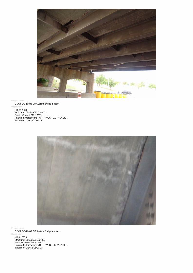
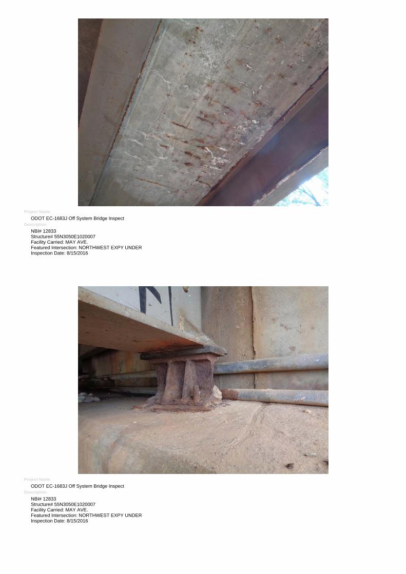
Elm.Env. Description Un. Qty. Qty.St. 1 % 1 Qty.St. 2 % 2 Qty.St. 3 % 3 Qty.St. 4 % 4 Qty.St. 5 % 512 4 Reinforced Concrete Deck (SF) 10,416 1,326 13 % 4,545 44 % 4,545 44 % 0 0 % 0 0 %
107 4 Steel Open Girder Beam (LF) 1,360 1,360 100 % 0 0 % 0 0 % 0 0 % 0 0 %
205 4 Reinforced Conc Column or Pile Extension (EA) 15 0 0 % 15 100 % 0 0 % 0 0 % 0 0 %
215 4 Reinforced Conc Abutment (LF) 140 43 31 % 97 69 % 0 0 % 0 0 % 0 0 %
234 4 Reinforced Conc Cap (LF) 194 0 0 % 194 100 % 0 0 % 0 0 % 0 0 %
301 4 Pourable Joint Seal (LF) 272 272 100 % 0 0 % 0 0 % 0 0 % 0 0 %
311 4 Moveable Bearing (roller, sliding, etc.) (EA) 40 4 10 % 36 90 % 0 0 % 0 0 % 0 0 %
313 4 Fixed Bearing (EA) 40 4 10 % 36 90 % 0 0 % 0 0 % 0 0 %
321 4 Reinforced Conc Approach Slab w/ or w/o AC Ov(EA) 4 2 50 % 2 50 % 0 0 % 0 0 % 0 0 %
333 4 Other Bridge Railing (LF) 372 372 100 % 0 0 % 0 0 % 0 0 % 0 0 %
515 4 Steel (Superstructure) Protective Coating (SF) 16,368 16,368 100 % 0 0 % 0 0 % 0 0 % 0 0 %
859 4 Soffit of Concrete Decks and Slabs (EA) 1 0 0 % 0 0 % 0 0 % 1 100 % 0 0 %
865 4 Steel Open Girder/Beam End (5 Ft.) (LF) 400 40 10 % 360 90 % 0 0 % 0 0 % 0 0 %
919 1 Steel (Railing) Protective Coating (SF) 613 613 100 % 0 0 % 0 0 % 0 0 % 0 0 %
958 4 Concrete Cracking (EA) 1 0 0 % 0 0 % 1 100 % 0 0 % 0 0 %
962 4 Superstructure Traffic Impact (EA) 1 0 0 % 1 100 % 0 0 % 0 0 % 0 0 %
963 4 Steel Section Loss (EA) 1 1 100 % 0 0 % 0 0 % 0 0 % 0 0 %
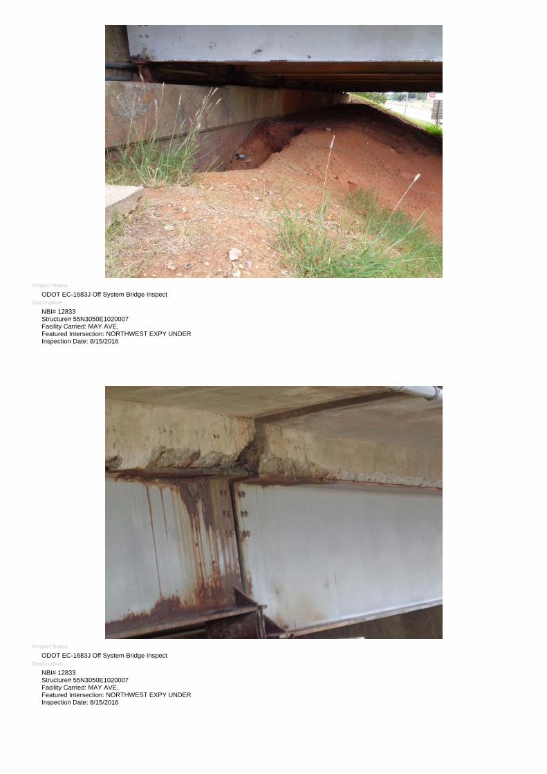
968 4 Erosion (EA) 1 1 100 % 0 0 % 0 0 % 0 0 % 0 0 %
AdditionalElements
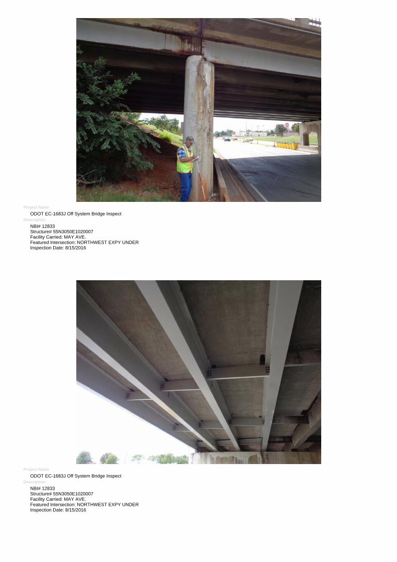
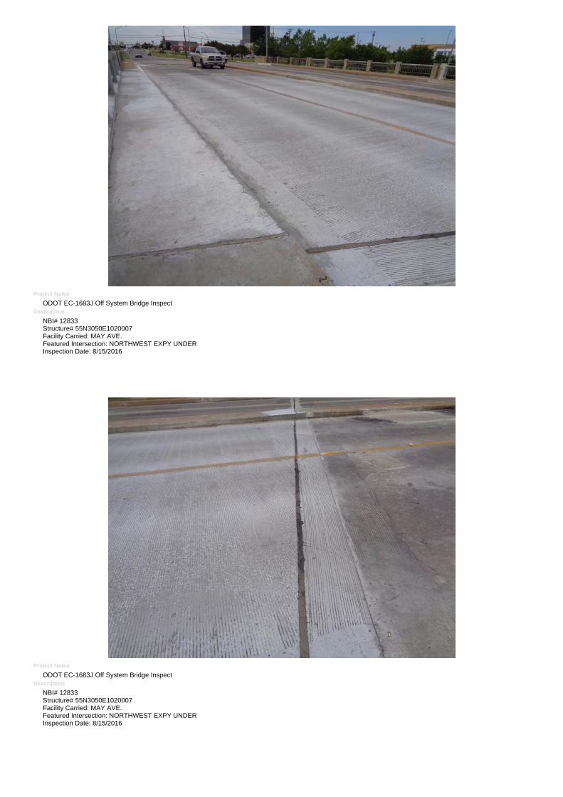
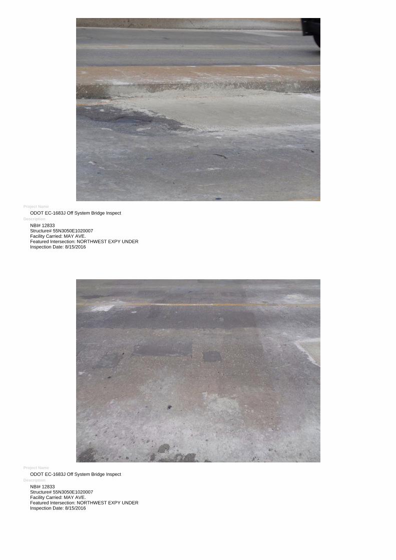
Element Notes (Include Size and Location of DeteriorationElem.PX - The deck has numerous patches thru-out the entire deck. Patching is heaviest in spans NO. 3 and 4; Approximately 60% to 70% OF SPANS 3 AND 4 ARE affected. -SEVERAL NEW SPALLS EXIST. NEW DECK EAST SIDE WESTBOUND.
12
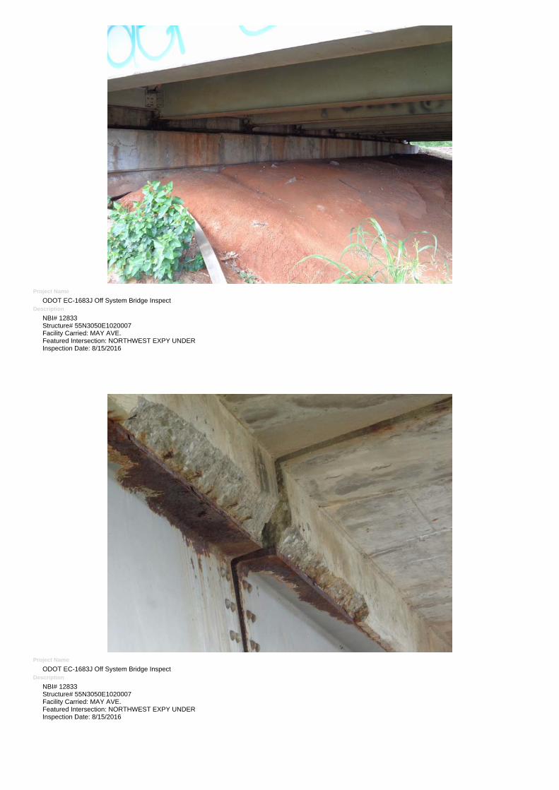
FX - Some recent painting done on #1 to #3 in span #2. Surface rust is started on the top of the lower flanges - mainly on beams #6 thru #10. - MOST BEAMS HAVE SOMERUST - EAST BEAM SPAN NO. 3 HAS A MINOR AREA OF IMPACT DAMAGE ON BOTTOM FLANGE, SPAN 2, MP 1, HAS SCUFFS FROM RECENT TRAFFICIMPACT. NO APPARENT DAMAGE TO SUPERSTRUCTURE. 4 NEW GIRDERS EAST SIDE WESTBOUND.
107
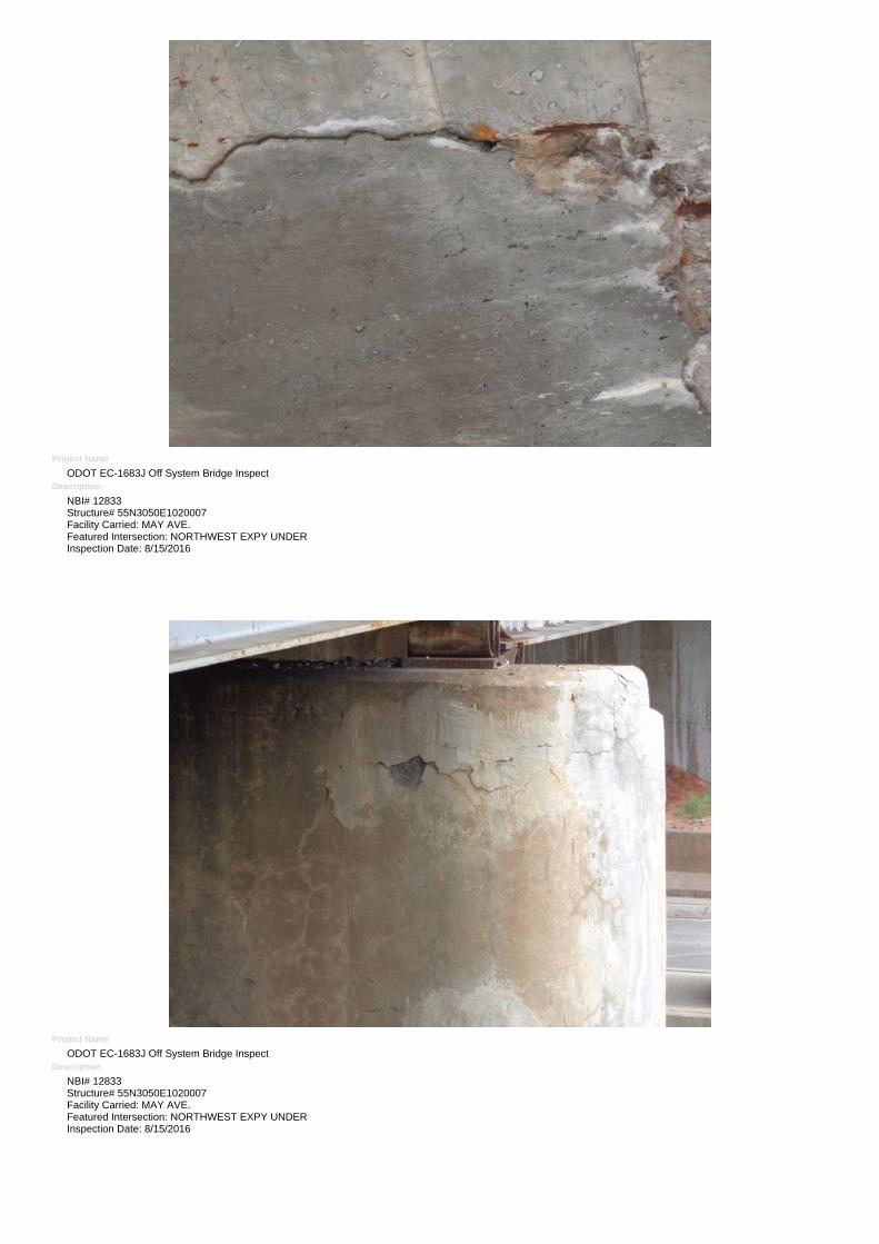
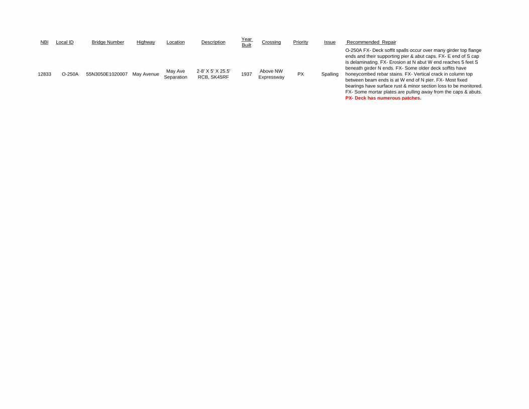
FX - Heavy cracking on the 1st column in bents #1, 2, & 3 and on column #5 in bent #3. Minor spalling on column #1 in bent #1; column #5 in bent #2; & column #4 in bent #3.The rest all have some light to moderate cracking. Repairs / patches made.
205
PX - Several moderate cracks are present on the NW area. The South has scale & popouts on most areas & some are present on the North as well. Still solid at this time. Repairs /patches made.
215
PX - Several areas of light to spalling with significant delaminations developing on each cap. Lots of lighter cracks, scale, & staining overall. Still serviceable at this time. -Repairs / patches made.
234
PX - All joints over bents have been re-sealed and repairs made.301
PX - The 5th & 6th rollers at bent #1 for span #2 - HAS BEEN REPAIRED - NO VISIBLE CRUSHING. All but 4 new rollers have surface rust with many having section loss onthe lower areas. Some mortar plates are pulling away from the caps & abutments.
311
FX - ALL BUT 4 NEW FIXED BEARINGS HAVE SURFACE RUST WITH MINOR SECTION LOSS313
FX - The NE, SE, & SW slabs have large unsealed cracks. The NE also has some minor settlement. The NW slab has some minor cracking. All still functioning as intended.321
PAINT FAILING.333
FAIR CONDITION.515
FX - The soffit has several areas of discoloration & some spalls with active corrosion present to the exposed rebar. Numerous older patched areas noted in spans #2 & 3. No looseareas present at this time.
859
PX - Some initial exfoliation & loss is present on some ends at bents #1 & 3. Lots of surface rust on each end on most areas. Needs cleaned & painted SOON. - WITHMODERATE LOSS ON EAST BEAM @ PIER #2 TOP FLANGE
865
FAILED CONDITION. SOME NEW PAINT ON EAST SIDE.919
FX - DECK HAS HAIRLINE TO 1/8 IN. RANDOM AND MAP CRACK THROUGHOUT, HEAVIER DENSITY RADIATING FROM JOINTS.958
EAST BEAM, SPAN 3 HAS A MINOR AREA OF IMPACT DAMAGE ON BOTTOM FLANGE. SPAN 2, BM 1, HAS SCUFFS FROM IMPACT, NO VISIBLE DAMAGE.962
PX - HEAVIEST EXFOLIATION TO FASCIA BEAM ENDS AT PIER NO. 1, WEST FACE, PIER NO. 3 WEST FACE963
FX - SOUTHWEST AND NORTHEAST CORNER BELOW SOUTH ABUTMENT WITH SOME EROSION - NO VISIBLE PILES - 8/20/2014 - NO CHANGE. MINOR.968
Inspected With:
Agency :
Mary Watkins
GWATKINS
Page 2 of 311/2/2016
NBI No.:12833 Structure No.:55N3050E1020007 Local ID:O-250A
Bridge Inspection ReportOKLAHOMA DEPARTMENT OF TRANSPORTATION -Health Index :
64.9Suff. Rating: 49.0
SD
NBI Information Applicable To The Route Under The StructureNORTHWEST EXPRESSWAY2 - 5 - 1 - 00000 - 0 102. Traffic Dir.:
104. Highway System :
105. Fed Land Hwy :
109. Truck ADT% :110. Natl. Truck Network :
114. Future ADT :
47. Total Horiz. Clr.(ft.):
51. Roadway Width (ft.) :
100. Defense Highway :
7
0 Not part of natl netwo55040
2 2-way traffic0 Not on NHS
0 N/A (NBI)
Roadway Name :5. Inventory Route (Route Under Structure :
19. Detour Len.(Mi.):
20. Toll Facility :
26. Function Class.:
Agency Field: 1.(Under Rte.): 2.(Vert. X-Ref.): 3.(Compass Dir.): 4.(Vert. Post. Inc.): 5.(Vert. Post. Dec.):-1 -1 -1 -1-1
16 Urban Minor Arterial
3 On free road
0.0 44.7
56.0
0 Not a STRAHNET hwy
10. Min. Vert. Clr.(ft.): 14.4
12. Base Hwy Network : Not on Base Network13. LRS Inv. Rt./ Subroute : -1 / -1 32. Appr. Roadway Width (ft.) : 74.0
29. ADT : 34400
628b. Lanes Und.:
Page 3 of 311/2/2016
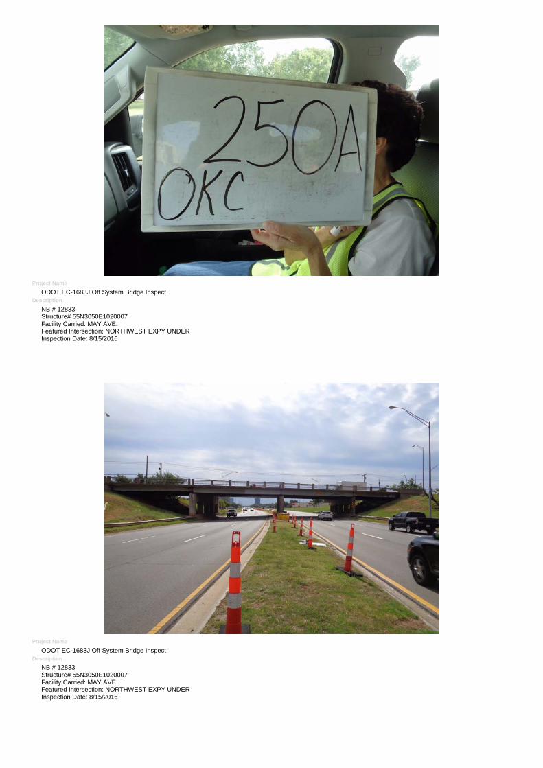
Project Name
ODOT EC-1683J Off System Bridge InspectDescription
NBI# 12833Structure# 55N3050E1020007Facility Carried: MAY AVE.Featured Intersection: NORTHWEST EXPY UNDERInspection Date: 8/15/2016
Project Name
ODOT EC-1683J Off System Bridge InspectDescription
NBI# 12833Structure# 55N3050E1020007Facility Carried: MAY AVE.Featured Intersection: NORTHWEST EXPY UNDERInspection Date: 8/15/2016
Project Name
ODOT EC-1683J Off System Bridge InspectDescription
NBI# 12833Structure# 55N3050E1020007Facility Carried: MAY AVE.Featured Intersection: NORTHWEST EXPY UNDERInspection Date: 8/15/2016
Project Name
ODOT EC-1683J Off System Bridge InspectDescription
NBI# 12833Structure# 55N3050E1020007Facility Carried: MAY AVE.Featured Intersection: NORTHWEST EXPY UNDERInspection Date: 8/15/2016
Project Name
ODOT EC-1683J Off System Bridge InspectDescription
NBI# 12833Structure# 55N3050E1020007Facility Carried: MAY AVE.Featured Intersection: NORTHWEST EXPY UNDERInspection Date: 8/15/2016
Project Name
ODOT EC-1683J Off System Bridge InspectDescription
NBI# 12833Structure# 55N3050E1020007Facility Carried: MAY AVE.Featured Intersection: NORTHWEST EXPY UNDERInspection Date: 8/15/2016
Project Name
ODOT EC-1683J Off System Bridge InspectDescription
NBI# 12833Structure# 55N3050E1020007Facility Carried: MAY AVE.Featured Intersection: NORTHWEST EXPY UNDERInspection Date: 8/15/2016
Project Name
ODOT EC-1683J Off System Bridge InspectDescription
NBI# 12833Structure# 55N3050E1020007Facility Carried: MAY AVE.Featured Intersection: NORTHWEST EXPY UNDERInspection Date: 8/15/2016
Project Name
ODOT EC-1683J Off System Bridge InspectDescription
NBI# 12833Structure# 55N3050E1020007Facility Carried: MAY AVE.Featured Intersection: NORTHWEST EXPY UNDERInspection Date: 8/15/2016
Project Name
ODOT EC-1683J Off System Bridge InspectDescription
NBI# 12833Structure# 55N3050E1020007Facility Carried: MAY AVE.Featured Intersection: NORTHWEST EXPY UNDERInspection Date: 8/15/2016
Project Name
ODOT EC-1683J Off System Bridge InspectDescription
NBI# 12833Structure# 55N3050E1020007Facility Carried: MAY AVE.Featured Intersection: NORTHWEST EXPY UNDERInspection Date: 8/15/2016
Project Name
ODOT EC-1683J Off System Bridge InspectDescription
NBI# 12833Structure# 55N3050E1020007Facility Carried: MAY AVE.Featured Intersection: NORTHWEST EXPY UNDERInspection Date: 8/15/2016
Project Name
ODOT EC-1683J Off System Bridge InspectDescription
NBI# 12833Structure# 55N3050E1020007Facility Carried: MAY AVE.Featured Intersection: NORTHWEST EXPY UNDERInspection Date: 8/15/2016
Project Name
ODOT EC-1683J Off System Bridge InspectDescription
NBI# 12833Structure# 55N3050E1020007Facility Carried: MAY AVE.Featured Intersection: NORTHWEST EXPY UNDERInspection Date: 8/15/2016
Project Name
ODOT EC-1683J Off System Bridge InspectDescription
NBI# 12833Structure# 55N3050E1020007Facility Carried: MAY AVE.Featured Intersection: NORTHWEST EXPY UNDERInspection Date: 8/15/2016
Project Name
ODOT EC-1683J Off System Bridge InspectDescription
NBI# 12833Structure# 55N3050E1020007Facility Carried: MAY AVE.Featured Intersection: NORTHWEST EXPY UNDERInspection Date: 8/15/2016
Project Name
ODOT EC-1683J Off System Bridge InspectDescription
NBI# 12833Structure# 55N3050E1020007Facility Carried: MAY AVE.Featured Intersection: NORTHWEST EXPY UNDERInspection Date: 8/15/2016
Project Name
ODOT EC-1683J Off System Bridge InspectDescription
NBI# 12833Structure# 55N3050E1020007Facility Carried: MAY AVE.Featured Intersection: NORTHWEST EXPY UNDERInspection Date: 8/15/2016
Project Name
ODOT EC-1683J Off System Bridge InspectDescription
NBI# 12833Structure# 55N3050E1020007Facility Carried: MAY AVE.Featured Intersection: NORTHWEST EXPY UNDERInspection Date: 8/15/2016
Project Name
ODOT EC-1683J Off System Bridge InspectDescription
NBI# 12833Structure# 55N3050E1020007Facility Carried: MAY AVE.Featured Intersection: NORTHWEST EXPY UNDERInspection Date: 8/15/2016
NBI Local ID Bridge Number Highway Location Description Year Built Crossing Priority Issue Recommended Repair
12833 O-250A 55N3050E1020007 May Avenue May Ave Separation
2-8' X 5' X 25.5' RCB, SK45RF 1937 Above NW
Expressway PX Spalling
O-250A FX- Deck soffit spalls occur over many girder top flange ends and their supporting pier & abut caps. FX- E end of S cap is delaminating. FX- Erosion at N abut W end reaches 5 feet S beneath girder N ends. FX- Some older deck soffits have honeycombed rebar stains. FX- Vertical crack in column top between beam ends is at W end of N pier. FX- Most fixed bearings have surface rust & minor section loss to be monitored. FX- Some mortar plates are pulling away from the caps & abuts. PX- Deck has numerous patches.