Embed Size (px)
Citation preview

[Ol M O^l 017949
REPORT
ON
THE CAMPANIA ISLAND SILICA DEPOSITS
BRITISH COLUMBIA
FOR
THE CANADIAN WESTERN SYNDICATE
By
A Li: rod R. Alien, P.Eng April, 1963

f\
* r ?J
:J
)
./ i-.
\
f
-')
V-
,-A.A^V,
• X \ \ \-i I
•J A > \ -K / ^ 7. o
BAM!-, r, -~\
i o - A r-l
"̂ » ■ . . / " " - -
,' A \ / \ \
\
'^vtfAN,-"-. \

THE CAMPANIA ISLAND SILICA DEPOSITS
CAMPANIA ISLAND
B, C.
INTRODUCTION
The silica deposits on Campania Island were
examined by Mr, E.J. Stephen and the writer April 2 to
6 inclusive,, /^^3
The purpose of the examination was to map and
sample the deposits of quartz and silica sand, and to
acquire available data pertaining to local mining and
transportation problems*
In his report dated April 11, Mr, Stephen
Included the itinerary of the trip, field methods used,
brief description of the deposits, road and barge~»loading
problems, and summary and conclusions regarding the
feasibility of acquiring and shipping suitable quart/,
from Campania Island, The writer herewith reports on
the geology, quantity and grade possibilities, and
additional diamond drilling which will be necessary to
supply the data required for specific grade and tonnage
calculations.
- 2 ~
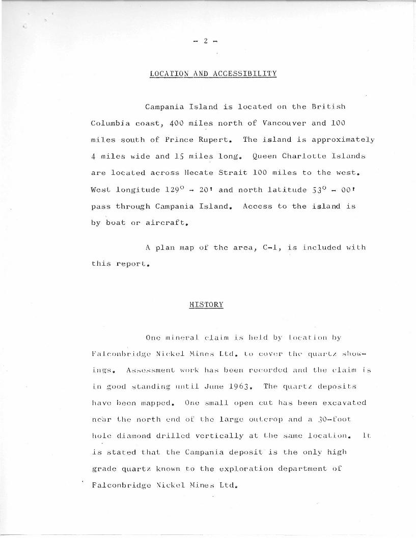
LOCATION AND ACCESSIBILITY
Campania Island is located on the British
Columbia coast, 400 miles north of Vancouver and 100
miles south of Prince Rupert. The island is approximately
4 miles wide and 15 miles long, Queen Charlotte Islands
are located across Hecate Strait 100 miles to the west.
West longitude 129° - 20 * and north latitude 53° - 00*
pass through Campania Island. Access to the island is
by boat or aircraft.
A plan map of the area, C—1, is included with
this report.
HISTORY
One mineral claim is held by Location by
l-'aiCambridge Nickel Mines Ltd. to cover' the quart-/ show
ings. Assessment work has been recorded and the claim is
in good standing until June 1963 • The quart/ deposits
have been mapped. One small open cut has been excavated
near the north end of the large outcrop and a 30-foot
hole diamond drilled vertically at the same location. It.
is stated that the Campania deposit is the only high
grade quart/ known to the exploration department of
Falconbridge Nickel Mines Ltd.

J
DESCRIPTIONS OF SILICA DEPOSITS
Campania Island is made up of Coast Range
granite,
One major and two minor showings of white
quartz occur about one—half mile from the west coast,
6 miles from the south end of the island. An unnamed
westerly—flowing creek makes a "hairpin" bend to the
south at the location of the quartz0
The major outcropping of quartz is dome-
shaped, The long axis strikes 10 degrees west of north,
The outcrop is 340 feet long and up to 100 feet wide,
At the highest point it is 55 feet above the lowest
exposure at the north end. About half of it is covered
with a thin layer of overburden,, It i .-. best exposed on
the north end and southeast half, although practically
ail of the west contact, and 60;/' of the east contact is
exposed. Both walls appear to dip from 70 to 90 degrees,
At the north and south ends it narrows to a point and
dips fairly steeply under overburden,
The quartz is white and translucent:, to
opaque. No apparent variation was observed throughout
the exposed part of the deposit. Numerous fracture and
strain lines, in almost all directions, are evident in the

Q.-2.
*
H
cxy£-*uJ^<./2££^.

/
H
C-G.
/ y * ■
A - -f\
U..:i
CLXX^J^'- &CZt~A.

~ 4 -
quartz. It appears to shatter easily. Only minor impur
ities were observed, these being a small area in which
there are scattered flakes of white to greenish colored
mica, and one very small flake of pyrite,
Inclusion of normal granite occurs throughout
the quartz« These appeared to be most numerous near the
southeast side and the north end. It is estimated that
they would amount to less than 5% of the quartz body by
weight *
At the contact, particularly near the north
end,, the granite has been altered and in place is a greenish—
grey rock with the felaspars partially kaolinized, and
considerable white mica present. This rock is softer than
the fresh grtinite and might tend to spall off when left
exposed on the wall of a quarry or stope,
Two hundred and twenty feet to the west of
the major quartz outcrop there* arc several smaLl irreguLar
bodies of quartz exposed on a smal i ridge, but I-hey are
too small to be of any cor\sequeneea
Across the unnamed creek about 500 feet to
the oast-, there are three exposures of quartz lying in a
north—south lino* The two northerly ones contain large
fragments of granite, and disseminated feldspathlc
mineralization throughout, making them obviously sub-
C-3
c «Q«C *A&i*».

~ 5 ~
grade quartz deposits. The south showing is 100 feet
long, up to 30 feet wide, and domed to 10 feet above the
muskeg and overburden. The west 10 feet of this outcrop
is composed of a mixture of quartz and granite,, The
east 20 feet appears to be quartz similar to that of the
main showing,, This deposit appears to be of minor
importance by virtue of the limited quantity and doubtful
grade of much of the exposed material.
On the east shorelines of two lakes lying
1-1/2 and 2-1/2 miles to the east of the quartz deposit
there are deposits of beach sand„ The top one to 24
inches of this sand is light brown in color and is composed
largely of feldspars quartz and mica. Below the top layer
is a dark brown colored sand containing feldspars, quartz
and mica along with considerable fine clayey material.
Because of flooding in the test holes which were) exca
vated the brown stratum was not exposed for more than 2
feet of thickness, hence it is possible there may be cLean
sand between this material and bedrock. On the east
shore of the most westerly lake the sandy beach is
estimated to be 1000 feet long. The exposed sand and that
clearly visible under water is not more than 200 feet wide,
On the east shoreline of the east lake there are two
beaches separated by a large rock outcrop. The south
beach has a sand deposit 120 feet Long and about 50 feet

wide including that portion extending into the lake, The
north beach has a sand deposit 100 feet long and 30 to 50
feet wide. Elsewhere on each lakeshore there is little or
no sand. At the east end of each lake there is a narrow
ridge of muskeg-covered bank which could be a sand dune.
Between the lakes, and westerly across the island past
the quartz deposits there are scattered areas of muskeg
separated by granite hummocks and low ridges0 Nowhere
does it appear that the granite bedrock is likely to be
covered by more than a thin layer of overburden and mus
keg, It is doubtful, therefore, that there is a deposit
of quartz sand of any sizeable tonnage at or near the
quartz showings on Campania Island,
SAMPLING AND ASSAYS
The large outcrop of quartz, designated as
deposit "An, was sampled at two locations, namely:
l0 A chip sample across the deposit about 40 feet from
(he north end and through the small open out and
diamond drill hole coLlar.- Three 20-foot samples
and one 1.6-foot sample were taken by hammer and moil,
20 Sixty feet from the south end a 70-foot chip sample
was broken up into three) 20-foot samples and one
10-foot sample, Assay results, listed below, average
98.84$ silica which is below the average of the 30-foot
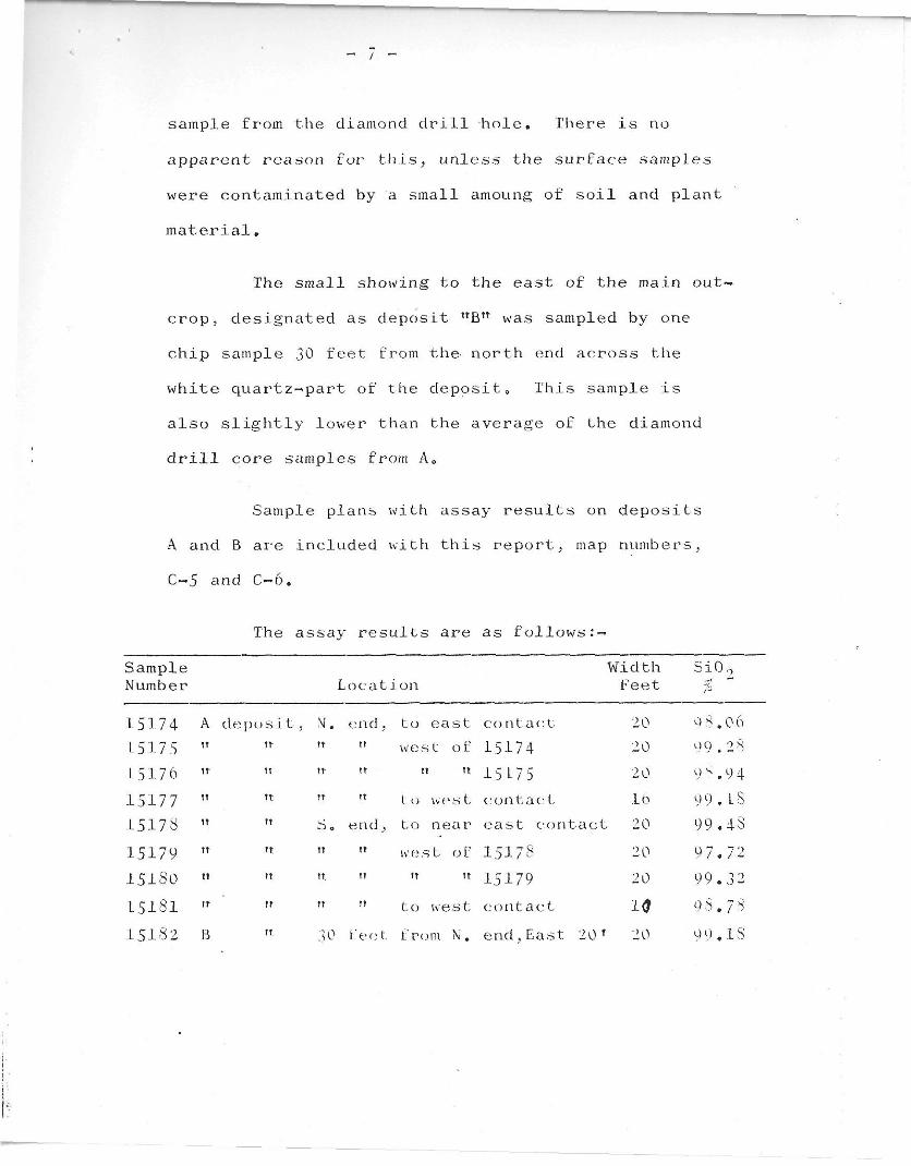
/
sample from the diamond drill hole. There is no
apparent reason for this, unless the surface samples
were contaminated by a small amoung of soil and plant
material.
The small showing to the east of the main out
crop, designated as deposit uBn was sampled by one
chip sample 30 feet from the- north end across the
white quartz-»part of the deposit,, This sample is
also slightly lower than the average of the diamond
drill core samples from Ae
Sample plans with assay results on deposits
A and B are included with this report, map numbers,
C~5 and C~6.
The assay results are as follows:-
Sample Width Si0o Number L 0 c a t ion Feet fi
15174 A deposit, M. ijnc\ , to east contact 20 9 8.06 L5175 tr tr tt west of 15174 20 9 9.28 15176 tt \t tr tt tt 15175 20 9 s. 9 4 15177 tt Tt tt t 0 wes t contact 16 99. LS 15178 TT S 0 end, to near eeist contac t 20 99.43 15179 u It tt w e s t 0 f I5I78 20 9 7.72 15180 tt It tt tt tt 15179 20 99.3 2 15181 it t! t» to west contact 10 9 8.78 15182 B It 30 feet- from N. end,East 20 ' 20 9 9 .18

C - 5
M ■-/ - >
96.06 99.28 93.91 G 99.18
'-.3 V
a^cy^.ax<^.

- 8 -
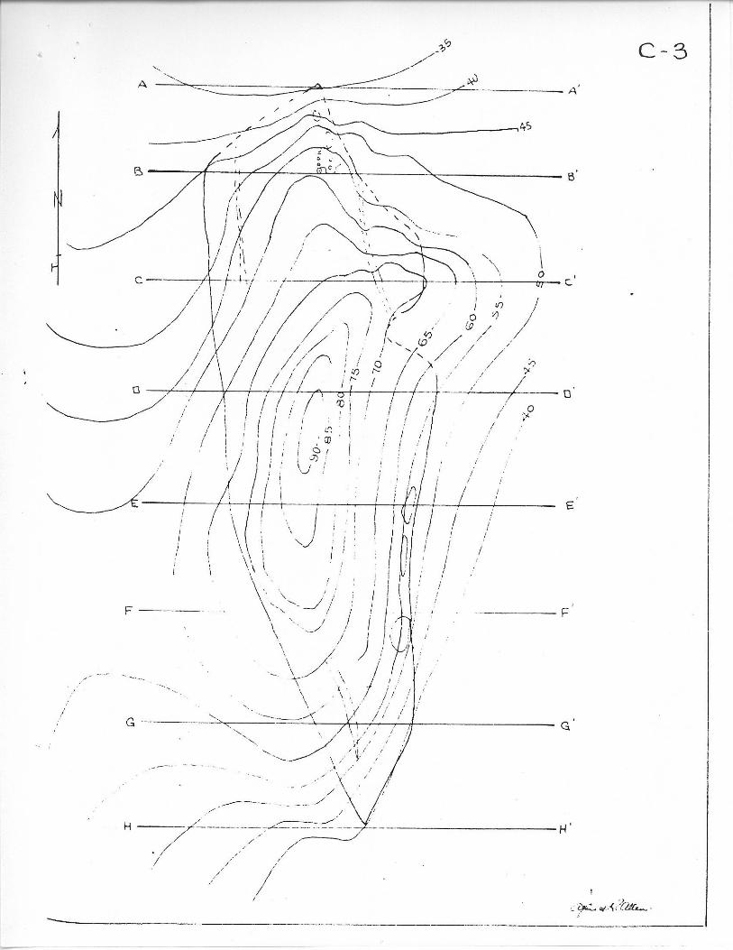
PRELIMINARY TONNAGE ESTIMATES
The deposits of quartz, designated as A and
B were mapped by chain, Brunton compass and anneroid*
From a N—S base line, sections were mapped along cross
lines at 50—foot intervals and geological and topographic
sketch plans made therefrom, These are included herewith
as maps C-2, C*-3.> C~5 and C-6. Section A-A passes through
the north end of the outcrop. Forty feet to the south,
section B-B* passes through the small open cut and diamond
drill hole* Sections C-Cf to H-H* inclusive are spaced
50 feet apart, and H-Hf passes through the south end of the
exposed quartz. The sections are shown on accompanying
Sheet C-4.
Anneroid readings were mapped as read. The
approximate correction for sea level 10 + 90 feet, but
this will require checking. Contours at S—foot intervals
were sketched» Sections in an east-west direction at right
angles to the base line were drawn using the level of the
south end of the exposed quartz on the surface datum,
This was 40 feet by anneroid reading. The sections have
been projected to zero anneroid reading, or 40 feet below
the exposed south end of the outcrop, and this is considered
zero datum level, The size and shape of the deposit is
such that it is deemed in order to consider the projection
of it to this depth fair and reasonable, and the calculated

^ - U - ^ - . IS u
ix
^ - U - ^ - . IS u
—' -****f* $/ rv^ ...... c'
: -£ - J
1 ' •""■ "
1 ;../5.V;:.
—'
...... c'
: -£ - J
1 ' •""■ "
1 ;../5.V;:.
—'
/ ^^^' • IVT~ ...... c'
: -£ - J
1 ' •""■ "
1 ;../5.V;:.
." T/ ^N
> \
...... c'
: -£ - J
1 ' •""■ "
1 ;../5.V;:.
7/ u 1 D'
>
... - / V 1
D'
>
...
i
E.
.-■ f i ; -
n ; n ■' e
H
j . . i * . - > ; .
'i . it A •-■'.:■
1 ' -r ay+~~*J?-.auu~.

- 9 -
tonnage in the category of proven reserves
Calculations for deposit A are as follows:—
!• Areas:
Estimated section areas, A 1,120 square feet B 4 ,576 " C 6 ,608 " D 8,464 ! t
E 6 ,560 « F 6 ,016 « G 3 ,056 l t
H 1,858 !t
Estimated plan area at zero datum, 37,300 square feet»
2. Tonnage:
To zero datum, using 10 cubic feet of quartz per short ton : —
North end A - B B - C C ~ D D - E E - F F - G G ~ H South end
3,300 11,392 27,960 37,680 37,560 31,440 22,680 12,285 4,645
Total estimate 188,942 short tons
For each additional foot of depth 3,730 tons,
or if the deposit remains uniform for an additional 100
feet of depth, 373,000 tons. Pending additional test work,
it appears reasonable to assume that there are 500,000
tons of quartz available from deposit A,
For deposit B the supply appears from present
exposures to be definitely limited,, Using the exposed
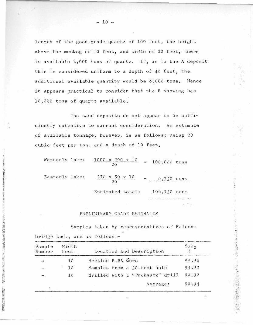
10 -
length of the good-grade quartz of 100 feet, the height
above the muskeg of 10 feet, and width of 20 feet, there
is available 2,000 tons of quartz. If, as in the A deposit
this is considered uniform to a depth of 40 feet, the
additional available quantity would be 8,000 tons,, Hence
it appears practical to consider that the B showing has
10,000 tons of quartz available*
The sand deposits do not appear to be suffi
ciently extensive to warrant consideration. An estimate
of available tonnage, however, is as follows; using 20
cubic feet per ton, and a depth of 10 feet.
Westerly lake: 1000 x 200 x 10 , n n nr.A _ J __ _ 100,000 tons
Easterly lake: 270 x 50 x 10 = 6 7^0 ton-20 * ^
Estimated total: 10 6,7 50 tons
PRELIMINARY GRADE ESTIMATES
Samples taken by representatives of Falcon-*
bridge Ltd., are as follows:—
Sample Width Si0 2 Number Feet Location and Description %
10 Section B~B*. Core 00.96 10 Samples from a 30-foot hole 99.92 10 drilled with a "Packsack" drill 99.92
Average: 99«9 4

- 1 1 ~
Samples taken by E.J. Stephen and AeR. Allen
are as follows:
Sample Number
Width Feet Location and Description
Si09
%
15174 20 Deposit D.D
A, N. end, through O.C. ► hole, E. Contact
& 98.06
15175 20 Deposit A, N. end west of 15174 99.28 15176 20 tr tt tt it ' n n 15175 98.94 15177 16 it lt n n to west contac t 99,18 15178 20 \t n S end, east side 99.48 15179 20 tr n n n west of 15178 97.72 15180 20 it tt tt tt tt tt 15179 99.32 15181 10 tr " " " to west contact 98.78 15182 20 Depos it B, 30 ft„ from N,end east half 99.18
Average for A deposit only 98084
The weighted average of all samples is 99.03% Si.Q.-,
Sand samples, taken by the staff of Falconbridge
Nickel Mines Ltd* are reported to assay up to 77% Si09^ es
timated to be equivalent to 38% quartz content0 The sands
were sampled as follows by A.R. Allen, but because of obvious
lack of quantity, these were not assayed:—
Sample Thickness Location and Description
15183 Top 2 inches East shore of westerly of two lakes, (unnamed). This is the clean white surface layer
15184 From 2" to 12" Dark brown sand, with fine silt. d e p t h
15185 From l2 T t t o l8 T t Brown s i l t , " h a r d p a n " d e p t h
Not. Top 12 inches numbered
Clean sand from south beach on east side of most easterly of two unnamed l£ikes. 6 bags of sand

12
ECONOMIC CONSIDERATIONS
Possible road and barge grid locations have
been described in Mr, Stephen*s report. The writer con
curs fully with Mr. StephenTs description of these and his
conclusions pertaining to same.
Mining quartz from the A deposit would present
no particular problem,, The following, pending further
study and planning as additional data is acquired, appear
to be the main points;-
1 0 The deposit may be quarried as deep below the ground
surface as the mining inspector will permit, depending
on conditions at the operation such as -
a) the slopes and condition of the walls of the quary,
b) benching and primary and secondary breaking methods.
2. Sizing on the site would likely be advisable.
3» Hand sorting to remove granite would be necessary to
maintain grade.
4. Pumping or syphoning would be necessary after the quarry
floor is lowered below ground level0
5. Growth and overburden would have to be removed from
the surface of the deposit and back from the edges of
tire quarry, to prevent contamination.
- 13 ~
6a It would be necessary to mine and remove a sizeable
amount of granite from both walls in order to maintain
safe wall slopes.
7. If the quartz is as highly fractured at depth as it
appears to be on the surface, and as decrepitation
tests of surface samples indicate, it may be necessary
to exert great care in both primary and secondary
breaking and in crushing to prevent excess fines*
8. It is obvious that in test drilling and mining, bit
wear will be considerably above normal.
9. It may be found necessary to use a 20% factor for
losses due to granite which would have to be sorted out
and discarded, ,runderbreaking,r along the walls of the
quarry in order to obviate the possibility of including
wallrock and fines.
SUMMARY
Surface sampling, along with one short diamond
drill hole, does not supply sufficient data for accurate
grade and tonnage calculations. The results herewith
summarized are, therefore, classed as preliminary estimates
- 14 ~
The A deposit contains 188,000 tons of quartz,
and unless the quartz exhibits abnormal changes below
surface, there should be 500,000 tons available to a
depth of 140 feet«
The grade as indicated by sampling to date is
marginal,, The 70—foot surface sample across the south
end, and the 75*-foot surface sample across the north end
of A deposit averaged 98„84% selica. On the north end,
however, the combined average of the surface 76—foot and
underground 30-foot samples is 99*15% silica0 The highest
assay, from 10 feet of the diamond drill hole, is 99*96%
silica; and the lowest, from a 20—foot surface section on
the south end, is 97*72% silica.
RECOMMENDATIONS
The Campania Island quartz deposit is one of
the few known sources of high grade silica on the west
coast of America, Although preliminary sampling indicates
that a grade of 99 * 5% could not be attained, there is a
possibility that the quartz will be found to be uncontam—
inated underground and a better than 99«0% siiiea supply
might be feasible* On the premise that satisfactory
markets can be acquired, and a reasonable deal finalized
with Falconbridge Nickel Mines Ltd., the writer is of the

- IS -
opinion that the A deposit should be tested by diamond
drilling*
The diamond drilling program should be planned
in three steps, as follows:
1» Limited drilling to check grade underground, holes
3 and 12 below.
2« Contingent on satisfactory results the drilling of
holes 5, 7 ) 9 and 11 below
3* Completion of 15 holes totalling about 4.* 000 feet of
drilling to supply sufficient data for grade and
tonnage calculations:
The following diamond drill holes would complete
these three stages,
From C.L, Vert. Length Sketch No. c ection E w Direction Angle. Feet No. 1 A + 60 N 60 West -60° 250 C-7 2 A + 60 N 50 East -60 250 C-7 3 A 40 West -60 250 C-7 4 A 40 East -60 250 C-7 5 B 30 West -60 250 C-8 6 B 60 East -60 250 C-S 7 C 70 East -50 250 C-8 8 D 50 East -60 300 C-9 9 E 50 West -60 300 C-10
10 F 50 We s t -60 300 C-ll 11 • G 50 West -60 250 C-12 12 H 50 West -60 250 C-12 13 H 50 East -60 250 C-12 14 H + ■50 S So West -60 300 C-13 15 H + 50 s 60 East -60 250 C-13
If Holes 3,950

~ 16 ~
In addition to the diamond drilling it may be advisable to acquire a bulk sample by excavating several trenches at least one foot deep across the A deposit.
Respectfully submitted,
Alfred Ra Allen, P, Eng.
Vancouver, B„ C. April 16, 1963.


![OL gih A= A=:=WB@W=B - Termo.pdf · )w;l jmpol; l n4 e ]lpql jlm l;lpn ]lpqm o]p q; qem l )P PNL;M OM ;LN4; M ;LNLYOM PN4 eL PM ^4L O5 ;L JLQM x OL JL OL N4 QLM OL PeL Q]LPQM L OL](https://img.pdfslide.net/doc/110x75/5f4eee7934ac651ea61403b8/ol-gih-a-awbwb-termopdf-wl-jmpol-l-n4-e-lpql-jlm-llpn-lpqm-op.jpg)
![$o ];| - l;-v u;l;m| ;v l-|; l;-v u; =uol | ; ;7]; o ... Sizing Guide E… · vol; ol;m l- 1omvb7;u - "l- t t u-l; : $o ];| - l;-v u;l;m| ;v l-|; l;-v u; =uol |_; ;7]; o= |_; mov;](https://img.pdfslide.net/doc/110x75/5ae849bf7f8b9acc268fe91a/o-l-v-ulm-v-l-l-v-u-uol-7-o-sizing-guide-evol-olm.jpg)