Embed Size (px)
Citation preview

1
Old Domain (Old Dominion) Mine, Lava Bed Mountains, San Bernardino County, California Gregg Wilkerson, 2020 [email protected]
Acknowledgement and Disclaimer The information in this paper is taken largely from published and public sources. I have reproduced this material and present it pretty much as we found it, not trying to harmonize discrepancies in mine or geologic descriptions. I have changed verb tenses for readability and have used some paraphrase. I have expanded abbreviations or special characters with full text (e.g. feet instead of ft., inches instead of “) Italics indicate quotations. Authors of the original information are indicated at the end of each paragraph. Paragraphs without a citation are our own materials. The maps in this report have been compiled and rectified from digital and paper copies of original sources that were made at different scales and in different geographic projections. Therefore, many of the maps had to be adjusted or stretched. They do not fit perfectly. Most are accurate to within 100 feet, but reproduction and projection errors can be as much as 300 feet for some maps. PLSS means Public Land Survey System. That survey data was obtained from the U.S. Bureau of Land Management website. MRDS, 2011, Mineral Resources Data System, U.S. Geological Survey, https://mrdata.usgs.gov/mrds/. This database relies on records that, in many cases, are inaccurate or imprecise. For example, if a report describes a mine as being in “Section 9”, with no other information, MRDS plots the mine location in the center of the section. If a mine is reported in “SW ¼” of a section, MRDS plots the mine in the center of that SW quarter-section. Where I could confidently adjust an MRDS location of a mineral deposit to features identifiable in aerial photographs or topographic maps, I did so. Help me make this report better. If you have any photographs, memories or reports for this mine that you can share, please send them to [email protected] so we can incorporate into this paper. Alternate Names: Ortega, Old Dominion LOCATION: (MRDS, 2011) 7N 6E Sec. 32 SBM 34.65835 -116.38141 7N 5E Sec. 36 SBM 34.65442 -116.39895 7N 6E Sec. 31 SBM 34.65422 -116.38275 T,7N, R.6E, Sections 31 and 32, SBM, Located 12 miles west of Ludlow (Goodwin, 1957, p. 656). OWNERS V. Anderson and Earl Fremont (1943) (Goodwin, 1957, p. 656).
2
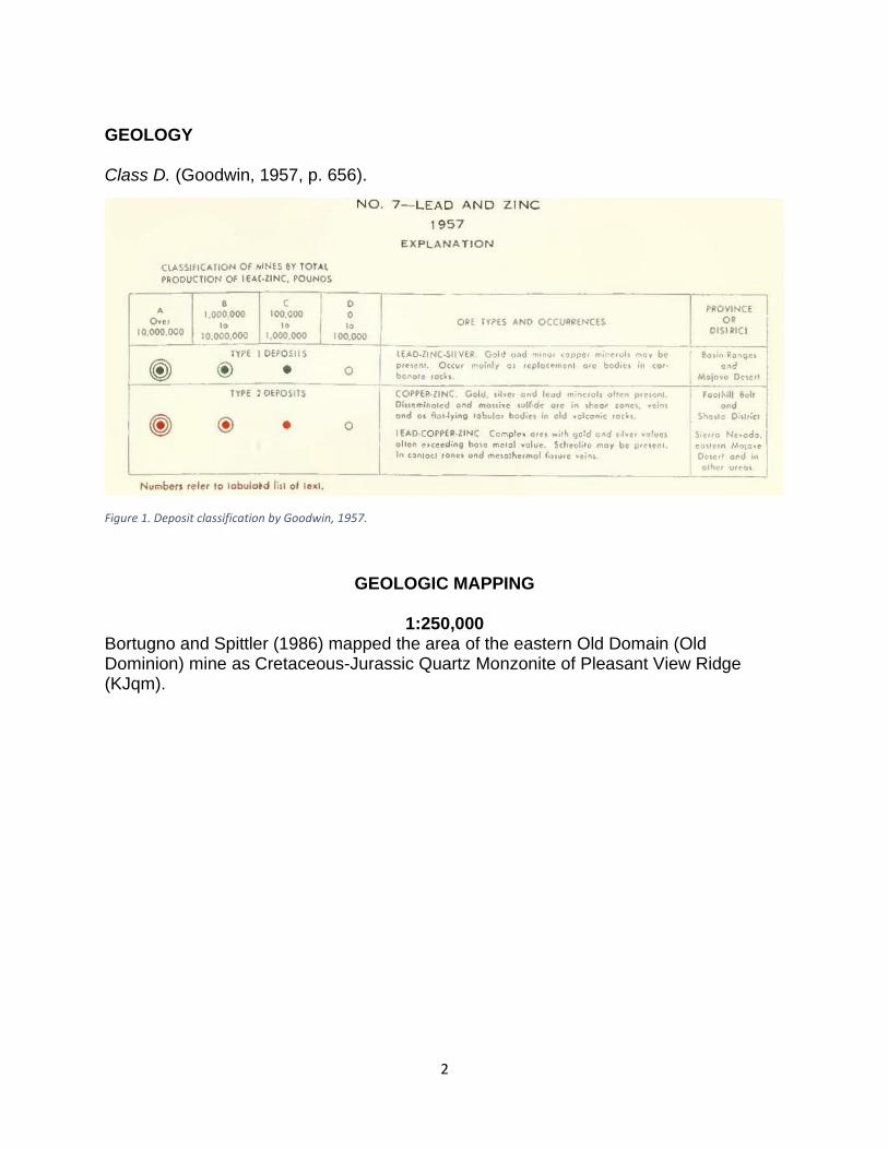
GEOLOGY Class D. (Goodwin, 1957, p. 656).
Figure 1. Deposit classification by Goodwin, 1957.
GEOLOGIC MAPPING
1:250,000 Bortugno and Spittler (1986) mapped the area of the eastern Old Domain (Old Dominion) mine as Cretaceous-Jurassic Quartz Monzonite of Pleasant View Ridge (KJqm).

3
The western Old Domain Mine is in Miocene intrusive diorite (Mid)

4
1:100,000 Phelps and others mapped the eastern Old Domian (Old Dominican) Mines as Miocene Sunshine Crater volcanics (Qvss) and Quaternary Hill Slope deposits (Qhs):
Phelps and others (2012) mapped the western Old Domain Mine as Quaternary Hill Slope Deposits (Qha) and Intermediate to mafic plutonic rocks (mp).

5
1:62,500
Dibblee (1966a) and Dibblee and Minch (2008d) mapped the area of the eastern Old Domain (Old Dominion) Mines as Quaternary Sunshine Peak Basalt (Qbs). They mapped the area of the western Old Domain Mine as Mesozoic diorite porphyry (dp).

6
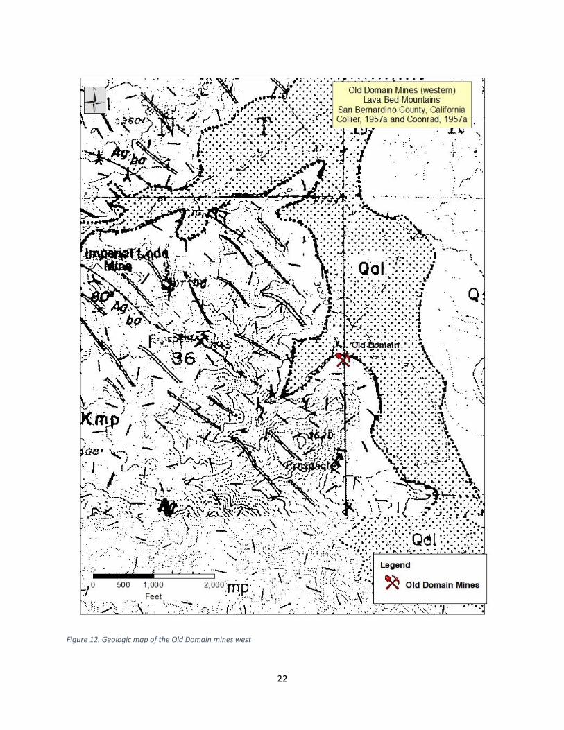
1:10:000 Collier (1957a) mapped the eastern Old Domain (Old Dominion) mines as Quaternary Sunshine Olivine Basalt (Qsb). The eastern mines lie along the Pisgah fault. They mapped the western Old Domain as Jurassic-Cretacous Monzonite Porphyry (JKmp) with numerous porphyritic dikes.
7
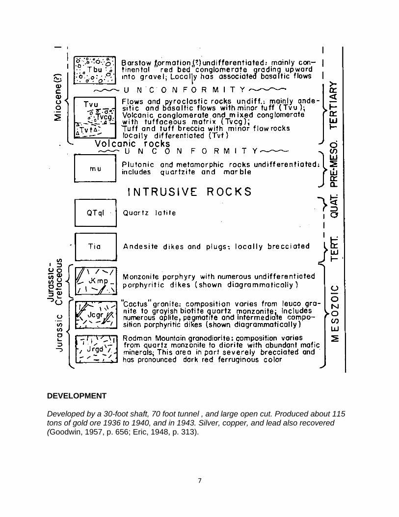
DEVELOPMENT Developed by a 30-foot shaft, 70 foot tunnel , and large open cut. Produced about 115 tons of gold ore 1936 to 1940, and in 1943. Silver, copper, and lead also recovered (Goodwin, 1957, p. 656; Eric, 1948, p. 313).

8
REFERENCES AND BIBLIOGRAPHY Aubury,_L. E., 1902, The copper resources of California: California Mining Bureau Bulletin 23, p. 250 and 282. Bortugno E.J. and T.E. Spittler, 1986, Geologic Map of the San Bernardino Quadrangle, 1:250,000, Regional Geologic Map Series, Map No. 3A (Geology), Sheet 1 of 5. Bulletin of the Mineralogical Society of Southern California (2006): 76 (April). Crawford, J. J., 1894 Mines and mining products of California: California Mining Bureau Report 12 pp 21-411. See p. 69. Crawford, J. J., 1896 Mines and mining products of California: California Mining Bureau Report 13, p. 61. California Geological Survey, Portions of various unpublished reports, and information from various Internet websites, contained in California Geological Survey (formerly California Division of Mines and Geology) Minefile Folder No. 322-5555. Collier, John T. and J.S Vanderpool, 1957, Aerial Economic Geology of T.6N, R.07 and 08E, SBM, Southern Pacific Corporation, Unpublished map in support of Minerals for Industry, Southern California Volume III, Special Publication 95, California Division of Mines and Geology, 1987; additions by R, Antil, A Cunningham an M. Schafer, 1958. Collier, J.T, C.L.D. Cohen and J.S. Vanderpool, 1957, Geology and Mineral Resources of Part of Townships 6 and 7 North, Range 8 East Half, San Bernardino Meridian, San Bernardino County, California – Includes Bagdad-Chase and Ragtown Gold-Copper District, Unpublished report, Southern Pacific Company in support of Minerals or Industry, vol. 3, p. 115. Dibblee, T.W., 1966a, Geologic map of the Lavic quadrangle, San Bernardino County, California: U.S. Geological Survey, Miscellaneous Geologic Investigations Map I-472, scale 1:62,500. Dibblee, T.W., 1967c, Geologic map of the Emerson Lake quadrangle, San Bernardino County, California: U.S. Geological Survey, Miscellaneous Geologic Investigations Map I-490, scale 1:62,500. Dibblee, T.W., 1967d, Geologic map of the Ludlow quadrangle, San Bernardino County, California: U.S. Geological Survey, Miscellaneous Geologic Investigations Map I-477, scale 1:62,500.

9
Dibblee, T.W., and Minch, J.A., 2008c, Geologic map of the Old Woman Springs & Emerson Lake 15 minute quadrangles, San Bernardino County, California: Dibblee Geological Foundation, Dibblee Foundation Map DF-380, scale 1:62,500. Dibblee, T.W., and Minch, J.A., 2008d, Geologic map of the Rodman Mountains & Lavic 15 minute quadrangles, San Bernardino County, California: Dibblee Geological Foundation, Dibblee Foundation Map DF-378, scale 1:62,500. Dibblee, T.W., and Minch, J.A., 2008f, Geologic map of the Ludlow & Bagdad 15 minute quadrangles, San Bernardino County, California: Dibblee Geological Foundation, Dibblee Foundation Map DF-396, scale 1:62,500. Eric, J. H., 1948, Tabulation of copper properties of California, in California Division of Mines Bulletin 144, p 313. Gardner, Dion Lowell (1940), Geology of the Newberry and Ord Mountains, San Bernardino County, California: California Division Mines Report 36: 257-292. Goodwin, J. G., 1957, Lead and Zinc in California, California Journal of Mines and Geology, California Division of Mines and Geology, Vol. 53 , No. 3 & 4; P. 353-724. See p. 656. Kojan, Eugene and John S. Vanderpool, 1956a, Aerial Economic Geology of T.5N, R.03 and 04E, SBM, Southern Pacific Corporation, Unpublished map in support of Minerals for Industry, Southern California Volume III, Special Publication 95, California Division of Mines and Geology, 1987. Modified by W.L. Coonrad, 1958. Kojan, E, F.A. Stejer and G. Olcott, 1956a, Aerial Economic Geology of T.7N, R.03 and 04E, SBM, Southern Pacific Corporation, Unpublished map in support of Minerals for Industry, Southern California Volume III, Special Publication 95, California Division of Mines and Geology, 1987. Mansfield, Ross, 2005, Off Road touring in the Buckeye mining district; Ludlow, Ragtown, Stedman and the Ludlow & Southern Railway: http://www.off-road.com/dirtbike/features/2005/ludlow_stedman/ Newman, M.A., 1923a, Los Angeles field division: California Mining Bureau Report 18, pp. 232, 307-311, 614,742-744. Newman, M.A., 1923b Los Angeles field division, San Bernardino County: California Mining Bureau Report19, pp. 29-32, 61-64, 98-100. Phelps, G.A., Bedford, D.R., Lidke, D.J., Miller, D.M., and Schmidt, K.M., 2012, Preliminary surficial geologic map of the Newberry Springs 30' x 60' quadrangle, California: U.S. Geological Survey, Open-File Report OF-2011-1044, scale 1:100,000.

10
Polovina, J. S., 1980a, Mineralized hydrothermal breccias in the Stedman district, San Bernardino County, California, in Fife, D. L. and Brown, A. R., Editors, Geology and Mineral Wealth of the California Desert: South Coast Geological Society; Santa Ana, California, p. 314-317. Polovina, J. S., 1980b, The geology and mineral deposits of the and vicinity, Stedman district, San Bernardino County, California [MS Thesis], University of California, Los Angeles, 125 pp. Polovina, J. S.,1984, Origin and structural evolution of gold-silver-copper bearing hydrothermal breccias in the Stedman mining district, southeastern California, in Wilkins, Joe, Jr., Gold and silver deposits of the Basin and Range province, western U.S. A.: Arizona Geological Society Digest, Vol. XV, Tucson, Arizona: 159-165. Polovina, J. S., 1987, Origin and structural evolution of gold-silver-copper bearing hydrothermal breccias in the Stedman mining district, southeastern California in Bulk mineable precious metal deposits of the western United States, Guidebook for field trips, April 6-8, 1987: 45-51. Rogers, Thomas H., 1967, Geologic Map of California, Olaf P. Jenkins Edition, San Bernardino Sheet, California Division of Mines and Geology, Scale 1:250,000. Southern Pacific Company, 1964, Minerals for Industry, Southern California, Volume 3, 269 p. See p. 117 . Storms, W.H., 1893, Lava Bed District, in San Bernardino County, State Mineralogist's Report XI, California Department of Natural Resources, Division of Mines and Mining, WM. Ireland Jr., State Mineralogist, pp. 349-358. Tosdal, R. M., Rytuba, J. J., Theodore, T. G., Ludington, S. L., Jachens, R. C., Miller, R. J., Keith, W. J.,1992, Evaluation of selected metallic and nonmetallic mineral resources, West Mojave Management Area, southern California: USGS Open-File Report 92-595, 89 pp. Tucker, W. Burling,1917, Pacific Mines Company, formerly Bagdad, Chase, and Roosevelt Mines: California State Mining Bureau Field Report Supplement 111; California Geological Survey (formerly California Division of Mines and Geology) Minefile Folder No. 322-5555. Tucker, W. Burling,1921, Los Angeles field division: California Mining Bureau. Report 17: 333-374. Tucker, W.Burling, 1923, Los Angeles Field Division, San Bernardino County California, Mining Bureau Report 19: 165-173.

11
Tucker, W. B., 1934a, Bagdad Chase & Roosevelt Mines: California State Mining Bureau Field Report #111, revised; California Geological Survey (formerly California Division of Mines and Geology) Minefile Folder No. 322-5555. Tucker, W. B., 1934b, Bagdad-Chase Mine tailings: California State Mining Bureau Field Report #37; California Geological Survey (formerly California Division of Mines and Geology) Minefile Folder No. 322-5555. Tucker, W. Burling, 1934c, Current Mining Activity in Southern California; San Bernardino County: California Journal of Mines and Geology, California Division of Mines, Report 30, Vol 30, No 4, pp. 325-326. Tucker, W. Burling & Reid J. Sampson, 1930, Los Angeles field division: San Bernardino County, California Mining Bureau. Report 26: 202-325. See p. 285. Tucker, W. Burling & Reid J. Sampson, 1931, Los Angeles Field Division; 27th Report of the State Mineralogist; San Bernardino County: California Mining Bureau. Report 27: pp. 262-401. See p. 358. Tucker, W. Burling & Reid J. Sampson, 1936a, Current mining activity in southern California: California Division Mines Report 32: Vol 32, No. 1, p 70. Tucker, W. Burling & Reid J. Sampson, 1940a, Current mining activity in southern California: California Division Mines Report 36, No. 3, p. 29. Tucker, W. Burling & Reid J. Sampson, 1940b, Economic mineral deposits of the Newberry and Ord Mountains, San Bernardino County: California Division Mines Report 36, No. 3, pp. 232-233. Tucker, W.B. and R.J. Sampson, 1943a, Los Angeles Field District, Journal of Mines and Geology, State Division of Mines, Vol., 39, No. 1, p. 443. Tucker, W. Burling & Reid J. Sampson, 1943b, Mineral resources of San Bernardino County: California Division Mines Report 39: 427-550. Tucker, W.B. and R.J. Sampson, 1943a, Los Angeles Field District, Journal of Mines and Geology, State Division of Mines, Vol., 39, No. 1, p. 443. Tucker, W. Burling & Reid J. Sampson, 1943c, Mineral resources of San Bernardino County: California Division Mines Report 39: 454-455 Wright, Lauren A., Ricard M. Stewart, Thomas E. Gay, Jr., and George C. Hazezbush, 1953, Mines and mineral resources of San Bernardino County, California: California Journal of Mines and Geology: 49(1-2), pp. 48-247 with tables. MAPS

12
Figure 2. Regional topographic map of the Old Domain (Old Dominion) Mine and surrounding area.

13
Figure 3. Regional geological map of the Old Domain (Old Dominion) Mine and surrounding area. From Bortungno and Spittler, 1986.

14
Figure 4. Land status map for the Old Domain (Old Dominion) mine and surrounding areas.

15
Figure 5. Regional geology of the Old Domain Mines. From Phelps and others, 2012.
16
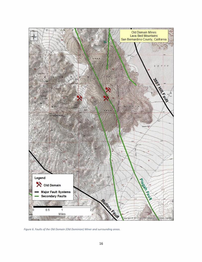
Figure 6. Faults of the Old Domain (Old Dominion) Miner and surrounding areas.

17
Figure 7. Topographic map of the Old Domain (Old Dominion) mine and other mines in the Lava Bed Mountains. Scald 1:24,000.

18
Figure 8. Area geological map of the Old Domain (Old Dominion) Mine and surrounding area. From Dibblee, 1966a.

19
Figure 9. Area geologic map of the Old Domain (Old Dominion) Mine. From Dibblee and Minch, 2008d.

20
.
Figure 10. Topographic map of the Old Domain (Old Dominion) Mines west

21
Figure 11. Topographic map of the Old Domain mines east.
.
22
Figure 12. Geologic map of the Old Domain mines west

23
Figure 13. Geologic map of the Old Domain mines east

24
Figure 14. Aerial photograph of the Old Domain (Old Dominion) mine west. From ESRI.

25
Figure 15. . Aerial photograph of the Old Domain (Old Dominion) mine east. From ESRI.